 Lijun Ma1
 Shi Yin
- 1College of Land and Resources, Hebei Agricultural University, Baoding, China
- 2College of Urban and Rural Construction, Hebei Agricultural University, Baoding, China
- 3College of Economics and Management, Hebei Agricultural University, Baoding, China
The main objectives of the study are to establish a rural-area multi-functionality evaluation index system, reveal the characteristics and identify influencing factors of rural-area multi-functionality differentiation in Hebei Province. A back-propagation neural network model and a spatial econometric model were used in the study. The results of this study as follows. The spatial differentiation of rural-area multi-functionality shows the opposite distribution to that of the agricultural production and economic development functions. The distribution of the socio-cultural function was found to be opposite to that of the ecological function, while the distribution of the socio-cultural function was found to be similar to that of the economic development function. There was a positive spatial correlation between rural functional patterns. The difference in rural-area multi-functionality development conditions was found to be the main reason for agglomeration distribution differences. The agricultural production function is mainly affected by agricultural, ecological, and industrial conditions. The function of economic development was found to be mainly affected by population and traffic conditions. The socio-cultural functions were found to be mainly affected by population and economic conditions. The ecological function was greatly affected by agricultural, population, and ecological conditions. This study provides further insights into the functions of rural regions and enriches the theories used in rural regional studies by closely analyzing the causes of the generation of and changes in rural-area multi-functionality. In the future, the government department should strengthen the construction of transportation, agricultural infrastructure, and industrial infrastructure.
1 Introduction
China has increasingly attached importance to rural areas and has put forward the strategic goal of rural revitalization to solve the problem of urban–rural dualism and the reality of agriculture, rural areas, and farmers’ lives. The state has issued relevant political documents, including the Opinions on Implementing the Rural Revitalization Strategy and the Strategic Plan for Rural Revitalization (2018–2022). These policies put forward that, on the basis of achieving new urbanization and urban–rural integration, we should fully mobilize the initiative of rural development and enhance the attractiveness of rural areas. Rural revitalization is the systematic process of rural transformation and development, rural space reconstruction, and functional rural improvements in a certain region (Liu, 2019). Rural-area multi-functionality concerns how a regional rural system within a certain region can have a positive effect on human society or nature through the interaction of the system itself or with other systems. More specifically, rural-area multi-functionality is the key to achieving agricultural modernization and rural value diversification, as well as the basis for stimulating rural regional development and achieving land multi-functionality utilization (Elahi et al., 2021a; Elahi et al., 2022a). Therefore, the study of rural-area multi-functionality has important guiding significance for the implementation of rural revitalization in different areas.
The theoretical study of land multi-functionality originates from the solution to spatial multi-functionality demands in regional planning. With further study, this theory has been confirmed as the theoretical basis of territorial spatial planning and zoning. Therefore, the quantitative evaluation of regional spatial function has become an important field of study in regional geography (Jansen and Gregorio, 2002). In contrast to the multi-functionality of land use, the multi-functionality of space not only considers the nature of the land itself, but also brings other factors of regional space into the scope of the function, such as culture and policy. The multi-functionality of space is able to consider the demands of multi-regional space in human production and more comprehensive lifestyles (Yin et al., 2022). Holmes (Holmes, 2006) proposed multiple goals of rural development and the sustainable development of the social economy in a study concerning the driving force of rural development for the promotion of the functional transformation of rural regions by responding to the diverse demands of rural areas. In the process of rural development, the transformation of rural-area multi-functionality promotes the formation of multiple functional patterns of rural regions. King (Peter et al., 2003) pointed out that the development of rural society produces diverse social demands. Rural areas must meet different social needs, resulting in different functions. Demarcating rural-area multi-functionality is an important means to achieving rural regional value.
Rural areas have irreplaceable regional functions such as agricultural production and cultural tourism. The satisfaction of rural-area multi-functionality for diverse rural needs is an important prerequisite for the comprehensive development of rural regions in the future (Liu et al., 2007). At present, the value collapse of rural areas is caused by the development of urban occupation of rural areas (Li et al., 2004). Therefore, it is imperative to conduct in-depth studies on rural-area multi-functionality. Rural landscape functions can be divided into seven categories: housing, intensive livestock, cultural heritage, tourism, plant habitats, arable land production, and leisure cycles (Yoshida, 2001; VeraToscano et al., 2005; Willemen et al., 2010). Jose et al. (José et al., 2012) put forward the concept of a universal function on the basis of a literature summary and analysis, and pointed out that a universal function includes economic functions, environmental functions, residential functions, and leisure and entertainment functions. Stola et al. (Baski and Stola, 2002) divided Suwalki province in Poland into six functional types based on land-use characteristics, social services, employment structure, and other indicators, with agriculture, industry, tourism, and forestry as the dominant functions. Based on the analysis of agricultural and non-agricultural functions, they revealed the regional differentiation characteristics of rural-area multi-functionality. Liu (Liu and Liu, 2012) believed that rural-area multi-functionality includes economic functions, agricultural product supply functions, social functions, ecological functions, and tourism and leisure functions. Hong et al. (Hong et al., 2017) divided the functions of rural space into five sub-functions: agricultural production, economic development, ecological conservation, ecological stability, and social security. Tan et al. (Tan et al., 2017) studied and analyzed rural areas based on the functions of economic development, food production, social security, and eco-tourism. Based on the general characteristics of the rural-area multi-functionality classification and the actual situation of Hebei Province, this study divides rural-area multi-functionality into agricultural production functions, economic development functions, socio-cultural functions, and ecological functions. Based on the evaluation index system, different types of rural areas were evaluated for versatility. This has become an important method for most scholars when conducting studies on regional multi-functionality. In the process of land multi-functionality evaluation, the evaluation methods of land multi-functionality are different due to the differences in the scale and index systems. Mathematical models with a high frequency of use include the weighted summation method (Qiao, 2019) and the entropy weight TOPSIS model (Tu et al., 2020), focusing on mathematical logic reasoning methods. In contrast, the BP neural network and other models based on intelligence principles have more advantages of self-organization, self-learning, and robustness (Cousins et al., 2002).
In terms of the formation and influencing factors of rural-area multi-functionality, Milestone (Martin and Josef, 2016) believed that the factors affecting the generation and development of different rural-area multi-functionalities were the differences in development level and infrastructure caused by different combinations of rural elements. Holmes (Holmes and Argent, 2016) believed that the reason for functional transformation is the change in rural residents’ concept of production and life. Šimon (Dedieu and Zasser-Bed oya, 2008), by studying the path taken by Czech rural development, pointed out that population growth, changes in the rural labor force level, and changes in rural governance modes are important factors that affect rural-area multi-functionality. Some scholars analyze the spatial layout of rural-area multi-functionality through an evaluation index system. Some scholars have conducted zoning studies based on the functional characteristics of rural regions. There are very few studies on the influencing factors of rural-area multi-functionality. In studies on the influencing factors of land-use multi-functionality, prominent scholars have given qualitative explanations to the influencing factors of land-use multi-functionality according to the spatial distribution characteristics of the functions. Moreover, these scholars have focused on the analysis of the influencing factors of longitudinal change. The spatial difference within the study area has very little influence on the rural-area multi-functionality.
To summarize, there are many achievements made by scholars in related research on rural areas, which provide the theoretical basis and technical reference for this paper. However, research based on the combination of the entropy weight method and BP neuron network model is relatively rare. The introduction of the BP neural network model and the spatial measurement model can enrich the research methods used for studies on rural regional functions and can further enrich the theory of rural geography. According to the existing studies, the driving mechanism of provincial rural regional spatial evolution is not clear, and there is a lack of analysis of rural regional spatial evolution and the influencing factors of development using the spatial measurement model. Therefore, we used the BP neuron model to evaluate rural-area multi-functionality under different terrain conditions in Hebei Province. Furthermore, the spatial econometric model was used to analyze the influencing factors of spatial differentiation. The introduction of the BP neural network model and the spatial econometric model can enrich the study methods used for rural geographical functions and can further enrich rural geographical theory. The analysis of functional spatial layout and its influence in Hebei Province can provide a theoretical basis for the improvement of land use efficiency and the promotion of regional sustainability in Hebei Province in the future.
2 Regional overview and data sources
2.1 Regional overview
Hebei Province, located in North China, is the only province in China with a complete range of plateaus, mountains, hills, basins, and plains. Hebei Province has Bashang Plateau, Yanshan Mountain and Taihang Mountain, and Hebei Plain’s three geomorphological units. Bashang Plateau is part of the Mongolian Plateau, including Fengning Manchu Autonomous County, Weichang Manchu and Mongolian Autonomous County of Chengde City, Chongli District, Zhangbei County, Guyuan County, Kangbao County, and other areas of Zhangjiakou City. Hebei Plain belongs to the north part of the Yellow River in the North China Plain, accounting for 43.4% of the province’s area, and is an important grain and cotton production area in China. Hebei Province is rich in animal, plant, and mineral resources. The spatial distribution of the study area in this study is shown in Figure 1.
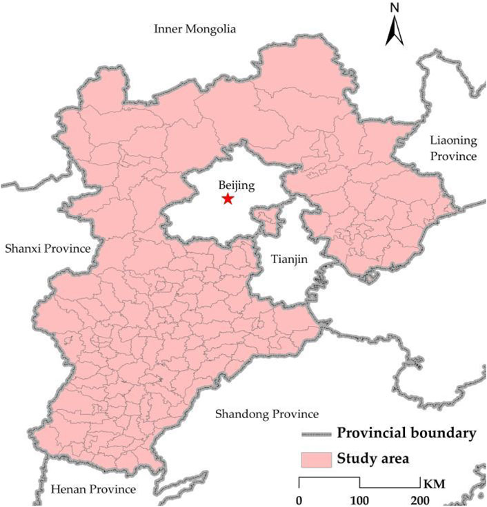
FIGURE 1. Spatial distribution map of the study area.
Hebei Province surrounds the capital, Beijing, and borders Tianjin city to the east, abutting the Bohai Sea. In 2017, the CPC Central Committee and the State Council decided to establish the Xiongan New Area in Hebei Province. In 2019, the State Council set up a new pilot free-trade zone in Hebei, covering Xiongan, Zhengding, Caofeidian, and Daxing International Airport. The pilot free-trade zone is an important region for the future development of China and has important practical significance for the study of rural areas.
2.2 Data sources
The land use data required by the study were mainly extracted from LandSAT-8 remote sensing data with a spatial resolution of 30 m. The spatial data of county, city and administrative boundaries were collected from the National Geographic Information Center, which contains 1:1,000,000 basic geographic information data. The data of rural social and economic development were mainly collected from the 2016 Hebei Rural Statistical Yearbook and the statistical yearbook of various cities and counties in 2016. The calculation method for the ecological service value was based on that described by Xie et al. (Xie et al., 2015). Additionally, the calculated results were modified according to the factors of farmland ecosystem biomass in different provinces. The missing data were from 2016 data or municipal economic almanacs.
3 Regional overview and data sources
3.1 Determination of index system
Agricultural production is an important part of the economy in rural areas, differing from that in urban areas. Cultivated land is the basis of agricultural production, and three indicators, including per capita cultivated land area, cultivated land quality, and land reclamation rate, were selected to evaluate the utilization of cultivated land (Xu and Fang, 2019). Grain yield per unit area refers to the grain yield per unit area of cultivated land, which can reflect the productive capacity of cultivated land (Liu et al., 2013). The output value of agricultural products obtained from agricultural production is also an important index by which to measure the productivity of agricultural land. Per capita grain output; per capita output value of farming, forestry, animal husbandry, and fishery; per capita ownership of meat; and per capita ownership of non-food crops are indicators reflecting agricultural production functions (Tang et al., 2016; An et al., 2018; Ma et al., 2019; Yang et al., 2019).
The key to the development of rural areas lies in the improvement of economic capacity, including the measurement of economic strength, non-agricultural economic development, and financial capacity. The average land GDP can better measure economic development strength (Tang et al., 2016). The development of a non-agricultural economy can be measured by three indicators: total output value of large-scale industry, industrial structure, and land area of industrial and mining production (Liu et al., 2013; Tan et al., 2017; An et al., 2018; Yang et al., 2019). The gross industrial output reflects the scale of industrial activity in rural areas. Industrial structure reflects the vitality of non-agricultural economic activities. Financial capacity is an important aspect by which to measure the economic development of a region. In this study, the local average financial contribution and local average fixed asset investment were selected to evaluate these (Liu et al., 2013; Tan et al., 2017; Ma et al., 2019; Yang et al., 2019).
Socio-cultural development in rural areas is closely related to the living conditions of villagers. The regional population density reflects the regional rural population distribution (Hong et al., 2017; Tan et al., 2017; An et al., 2018; Qiao et al., 2019). The residential area reflects the size of the villagers’ living space in different areas. The social consumption level represents the villagers’ consumption levels (VeraToscano et al., 2005). In addition, medical and health conditions, farmers’ medical insurance coverage rates, the degree of educational resource support, electric power facilities, and road mileage reflect the infrastructure and social security situation in rural areas (Tang et al., 2016; Tan et al., 2017; An et al., 2018; Qiao et al., 2019).
Ecological function in rural areas refers to the relative importance and self-regulation ability of rural regional ecological environment (Xu and Fang, 2019). The ecological function should include the forest coverage rate, the ecological space area, per capita ecological space area, and the water area ratio. Additionally, the damage to agricultural activities caused by fertilizer and pesticide use rates should also be measured. Finally, we used the study methods of Xie (Xie et al., 2015) and others to calculate the regional ecological service value to obtain the average geographical ecological service value (Table 1).
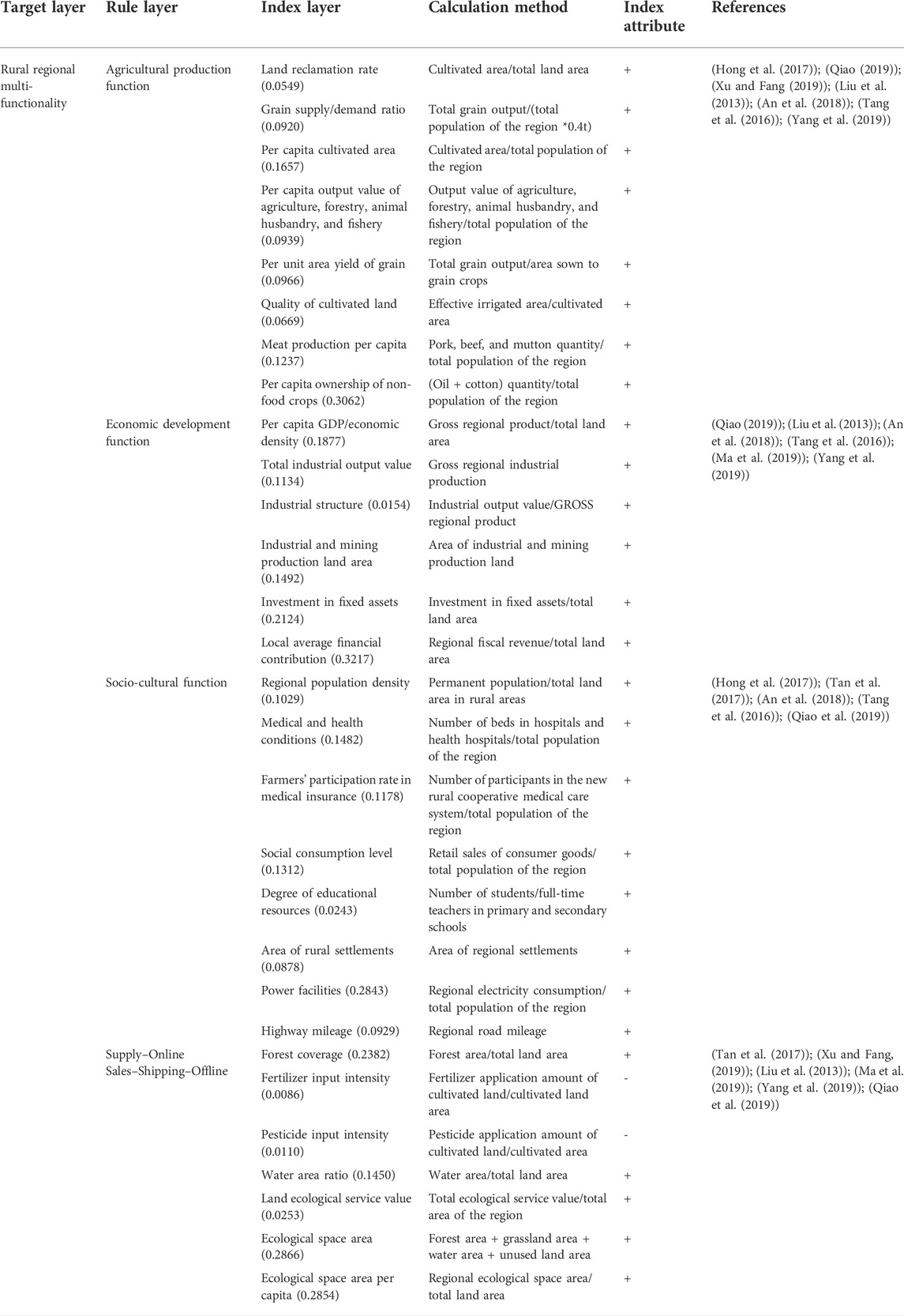
TABLE 1. Index system and weight of rural regional multi-functionality evaluation.
3.2 Entropy weight method
Because multiple indexes are involved and since the data units cannot be unified, the range method was used to normalize the data to eliminate the dimensional influence. After the standardized data were obtained, the entropy method was used to calculate the index weight and the evaluation value of each function. This operation was performed to provide standard values for the BP neuron model, which can eliminate subjective bias to a certain extent (Xia et al., 2020). The calculation process was as follows:
(1) Data normalization:
(2) Entropy weight:
(4) Index differentiation coefficient:
(5) The index difference coefficient
(6) The score
3.3 BP neuron model
The BP network model is a supervisory network type based on error back propagation. This model can modify the weights of neurons in each layer of a BP neural network through the calculation and feedback of input information, output information, and error. Minimum error signals can be obtained to form the final network model (Li et al., 2012). This network model can not only enhance the comparability of the evaluation results, but can also further optimize the evaluation results obtained by the entropy weight method (Elahi et al., 2020; Elahi et al., 2022b). In this study, the standardized data of the agricultural production, economic development, socio-cultural, and ecological functions were used as the input layer of the model. The evaluation values of the agricultural production, economic development, socio-cultural, and ecological functions were taken as the output layer. A BP neural evaluation with four hidden layers was constructed to measure the functions of rural areas.
In the process, the linear interpolation method was used to determine the learning sample. The MATLAB neural network toolbox was used to construct and train the BP neural networks. The grid structure of the agricultural production function was 8–10–1, and that of the economic development function was 6-8-1. It was 8–15–1 for the socio-cultural functions and 7–10–1 for ecological services. The Newff function and the trial-and-error method were used to determine the optimal network structure of the production function, and the formula was as follows:
3.4 Spatial autocorrelation test
Global Moran’s I Index and Local Moran’s I Index were used to confirm whether there was a correlation between the spatial differentiation of each function value (Getis, 1992; Yu and Chang, 2021). In this study, 167 spatial units of counties and urban areas were taken as samples and analyzed with the help of the spatial analysis function of Geoda095i software. A binary neighborhood spatial weight matrix was established; Moran’s I Index and a LISA diagram were used to represent spatial differentiation. The calculation formula of Moran’s I Index was as follows:
where
3.5 Spatial econometric model
The traditional least square model ignores spatial dependence, which may lead to the deviation of the model estimation. The spatial econometric model can reflect spatial dependence very well (Anselin, 1995; Li et al., 2019). The fitting degrees of the spatial autoregressive model (SAR), the spatial lag model (SLM), and the spatial error model (SEM) were compared to select the optimal model in this study. Stata software was used to analyze the influence of error terms of the surrounding districts and counties for target counties, and the model was set as follows:
The production process of disturbance term
where
We selected the factors that influence the development of rural-area multi-functionality from the two aspects of internal driving force and external driving force. The internal driving force was divided into four aspects: agricultural conditions, population conditions, traffic conditions, and ecological conditions. The index system of the influencing factors of rural-area multi-functionality evolution is shown in Table 2.
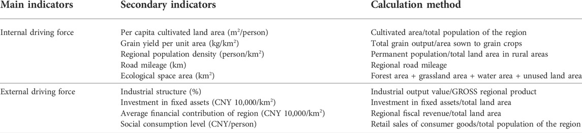
TABLE 2. Index system of influencing factors of rural-area multi-functionality evolution.
4 Results and discussion
4.1 Spatial differentiation of rural-area multi-functionality
As can be seen in Figure 2, the high values of the agricultural production function are concentrated in the northwest, east, and southeast of Hebei Province. Kangbao county and Zhangbei County of Zhangjiakou city in the northwest have a good production capacity for the animal husbandry-processing industry and the characteristic agricultural products-processing industry. The high-value areas in the southeast include Zhengding County, Xinle City, and Xinji City of Shijiazhuang City. Zhengding County is a wheat planting base, while Xinle city has formed an agricultural economic pattern of “three kinds and two crops” with five characteristics. Xinji is an important area in Hebei Province that produces high-quality cotton and pears. Guantao County has a high output of eggs, black wheat, and cucumbers, which have become its main agricultural products. Changli County in the eastern city of Qinhuangdao has a history of fruit growing and fishing ports. Luannan County and Luanzhou City of Tangshan City have a large area of cultivated land. The high-value areas are generally traditional agricultural counties with large cultivated areas. Moreover, these regions have their own characteristic agricultural products, and the government departments actively promote the industrialization of agriculture in this region. The middle and low values are mainly concentrated in the area around Beijing and Tianjin, and in the southwest and northeast. These districts and counties are located in mountainous areas with complex terrain, and agricultural development is limited.
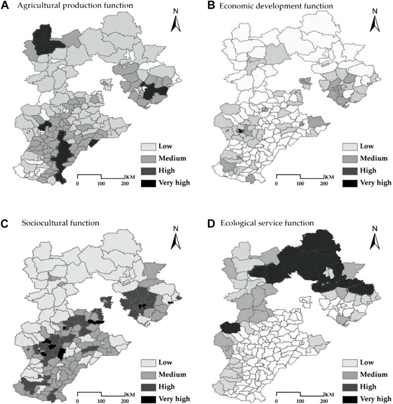
FIGURE 2. Spatial differentiation of rural-area multi-functionality in Hebei Province.
The high-value economic development function areas are Yuhua District, Qiaoxi District, and Chang ’an District. These districts and counties are located in the center of the provincial capital city with frequent economic activities. The high values are mainly in the central urban areas of each city. ITangshan City, Lunan District, Lubei District, Caofeidian District, Kaiping District, Fengnan District, and Fengrun District show a high concentration distribution. The main reason is that Tangshan has developed industrial industries and convenient transportation in these areas. Medium and low values are widely distributed in counties far away from the central urban area. The economic development center of Hebei Province is mainly concentrated in the surrounding areas of Beijing, Tianjin, and the coastal areas, while the economic development of other regions lags behind these.
The socio-cultural functions are distributed among low and medium-high values, and the area is characterized by the division between Pingshan County and Chengde County. The high values are scattered in the southern half. North of the Pingshan County–Chengde County line is mainly mountainous terrain, and the economic development function is weak. As a result, the population distribution is low and the level of socio-cultural development is low. In the Pingshan County–Chengde County line south of the area, there has been frequent human activity with a profound historical culture since ancient times.
The ecological services with high values were mainly distributed in the north and northeast of Hebei Province. Most of the northern high-value counties are located in the Dama Mountains region and Taihang Mountains region, with a large forest area. The high-value area in the northeast is located in the Luanhe River Basin, and there are two large reservoirs, Panjiakou Reservoir and Daheiting Reservoir. The low-value area is mainly located in the southeastern plain area, which is the main cultivated land distribution area in Hebei Province. Human social and economic activities are very frequent, and the ecological environment is greatly affected.
A comparative analysis of the spatial differentiation feature maps of the four functions showed the following results. The distribution of the high and low values of agricultural production function is roughly opposite to that of the economic development function. This shows that the economic development capacity of regions with a high agricultural production capacity is very weak. The regions with high economic development capacity have few agricultural production activities. Similarly, the distribution of the high and low values of socio-cultural function is roughly opposite to that of the ecological function. This indicates that the ecological function is weak in areas with high socio-cultural functions. This is related to the distribution of the population and the frequency of socio-cultural activities. Densely populated areas are generally ecologically weak. The high-value economic development function regions are similar to the high-value socio-cultural function regions. In economically developed areas, socio-cultural activities are also very frequent, and the functional value is also high.
4.2 Spatial agglomeration characteristics of rural-area multi-functionality
4.2.1 Global correlation
The rural functional values of Hebei Province were used to calculate the Moran’s I value and to analyze the spatial correlation of the rural functional values. According to the Moran’s I values of each function (Table 3) and the distribution of functional Moran scatter points (Figure 3), the spatial distribution of each rural-area multi-functionality in Hebei Province was found to be positively correlated. This shows that the spatial econometric model can be used to analyze the factors influencing the formation of the rural-area multi-functionality differentiation characteristics of each rural area.
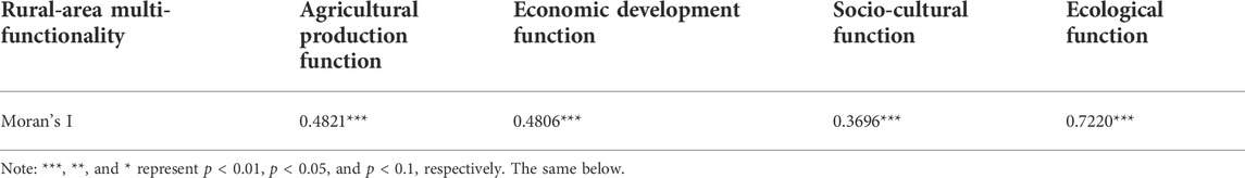
TABLE 3. Moran’s I value of rural -area multi-functionality in Hebei Province.
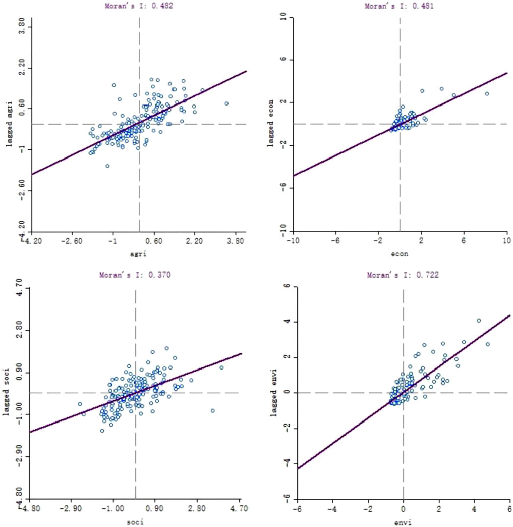
FIGURE 3. Moran’s I scatter diagram of rural-area multi-functionality in Hebei Province.
4.2.2 Local correlations
As can be seen from the LISA diagram of each function (Figure 4), the spatial aggregation of the high and low values of the four functions is different. The “high–high”-type agricultural production function includes Kangbao County, Changli County, Caofeidian District, Leting County, Luannan County, and most counties in the southeast. This shows that in the plain area of Hebei Province, agricultural regions interact with each other and cooperate to a significant extent. The “high–high”-type economic development function includes Fengnan County, Lunan District, Lubei District of Tangshan City and Yuhua District, Chang ‘an District, Qiaoxi District, Xinhua district, Luquan District, and Gaocheng District of Shijiazhuang City. This shows that the cooperation between counties with high economic capacity and surrounding counties can produce a radiating and driving effect on them. The “low–low” type is mainly distributed in the north, parts of the central region, and the southeast. These areas are affected by regional conditions and their own economic conditions, forming slow-economic-development area. The “high–high”-type distribution of socio-cultural functions is roughly the same as that of the economic development functions. This shows that, compared with areas with a low level of economic development, socio-cultural activities are more abundant in areas with high level of economic development. Additionally, socio-cultural exchanges with the surrounding regions are more frequent. The “low–low” type is mostly distributed in the northwestern half of Hebei Province. These areas have slow economic development and are located in mountainous terrain. Moreover, transportation conditions are relatively poor and population density is low. The “high–high”-type ecological function covers a large area and is distributed in the northern part of Hebei Province. This shows that there is a positive mutual ecological impact in areas with a good ecological environment. The distribution of the “low–low” types is also large and concentrated in areas of high agricultural production. This shows that agricultural production activities have damaged the ecological environment. For example, the use of chemical fertilizers and pesticides has a negative impact on the ecological environment of surrounding counties.
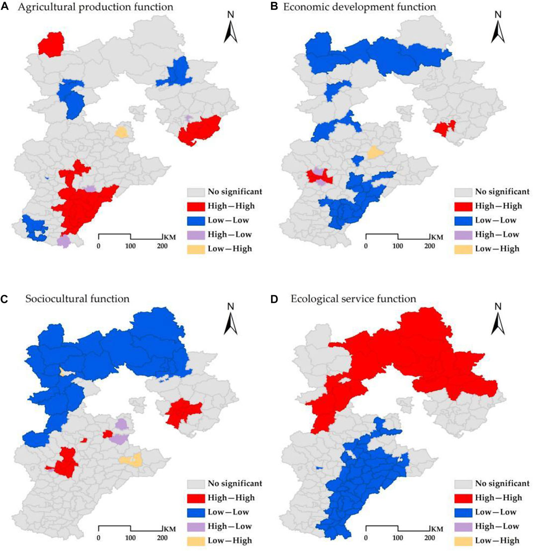
FIGURE 4. LISA map of rural-area multi-functionality of Hebei Province.
4.3 Influence mechanism of the distribution of rural-area multi-functionality
The R2 and log likelihood values of the SAR, SLM, and SEM models (Table 4) were compared and analyzed. According to the comparative analysis results, the spatial error model (SEM) had the best fitting effect. Therefore, the results of the spatial error model were used as the result values to evaluate the influencing factors.
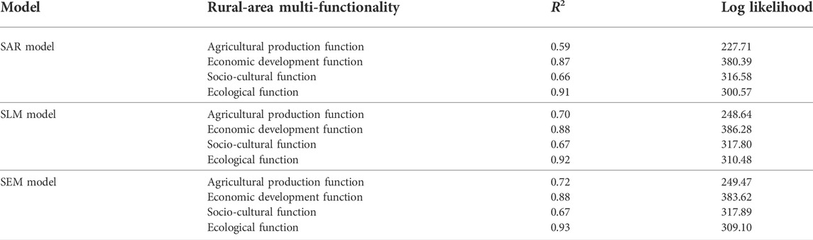
TABLE 4. Results of spatial econometric model fitting.
From the results of the spatial lag model (Table 5), it can be seen that the per capita cultivated land area, the grain yield per unit area, the road mileage, and the per capita fixed asset investment have had a positive impact on the agricultural production function. The ecological space area, industrial structure, and average fiscal contribution have had negative effects. The results show that agricultural conditions, traffic conditions, and policy conditions are positively correlated with the agricultural production function. The better the agricultural conditions, transportation, and policy conditions, the higher the agricultural productivity. A particularly important factor is agricultural conditions. If the per capita cultivated land area and grain yield per unit area increase by 1%, the agricultural production function can increase by 6.14 and 2.65%, respectively. Improving the quantity and quality of the cultivated land is the key to enhancing the agricultural production function. Ecological conditions, industrial conditions, economic conditions, and the agricultural production function are negatively correlated. In a certain region, there is a direct contradiction between economic development, ecological protection, and agricultural production. Agricultural production is affected by increases in cultivated land occupying ecological areas. In the most developed regions, agriculture has been replaced by industry and services. Labor and resources flow to the secondary and tertiary industries with high economic efficiency.
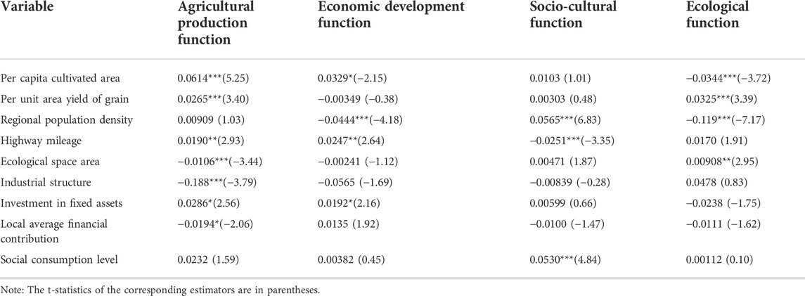
TABLE 5. Results of spatial error model.
In terms of the economic development function, highway mileage and fixed asset investment per land have a positive impact on it. The better the transportation and policy conditions, the better the economic development. Traffic conditions are a key location condition and the foundation of economic development. A 5% increase in the number of traffic miles can increase the economic development function by 2.47%. In addition, fixed asset investment is a significant part of regional economic development. A 10% increase in investment will increase the economic development function by 1.92%. Demographic conditions have a negative impact on economic development. This shows that in most areas of Hebei Province, increases in population are an economic burden and put pressure on the resources of districts and counties. Increases in the per capita cultivated land area can also lead to decreases in the economic production function value. Increases in cultivated land mean that the area of land used for construction is reduced accordingly.
Population conditions and social consumption levels have a positive influence on the improvement of socio-cultural functions. Each 1% increase in population density and social consumption levels will increase the value of the socio-cultural function by 5.65 and 5.30%, respectively. The higher the population density and the more consumption it produces, the more socio-cultural activities it produces. Therefore, the function value is higher under these conditions. On the contrary, road mileage has a negative influence on socio-cultural level.
In terms of the ecological function, the grain unit yield function increased by 3.25% when it increased by 1%. The higher the quality of the cultivated land, the higher its utilization efficiency. In this case, the less arable land needed to meet food demand, the smaller the ecological impact. Each 5% increase in the ecological space area will increase the ecological function by 0.908%. The larger the ecological space area, the greater the ecological benefit and the higher the function value. The area of cultivated land per capita and population density have negative effects on the ecological function. To a large extent, increases in arable land and population mean reductions in the ecological area, which generates more pollution.
5 Conclusion and future study directions
Rural-area multi-functionality is a hot topic in regional and rural geography studies in the context of “rural revitalization”. It also concerns studies on the role of rural regional space. Its spatial heterogeneity provides rural areas in each region with unique functions that do not exist elsewhere. In this study, the BP neural network model and the spatial econometric model were used to analyze the spatial differentiation and influencing factors of rural-area multi-functionality in Hebei Province.
This study draws the following results. 1) The distributions of the agricultural production and economic development functions are opposite in Hebei Province. The distributions of the socio-cultural function and the ecological function are opposite. The high-value distribution area of the socio-cultural functions is similar to that of economic development. 2) From an overall point of view, the four rural-area multi-functionalities of Hebei Province have a positive spatial correlation. The distribution of “high–high” and “low–low” clusters of various functions is closely related to the development conditions of the regional functions. 3) The agricultural production function is greatly affected by the agricultural, ecological, and industrial conditions. The function of economic development is mainly affected by population and traffic conditions. The influencing factors of the socio-cultural function are population and economic conditions. The ecological function is greatly affected by agricultural, population, and ecological conditions.
The theoretical implications of this study are as follows. In general, the functional distribution of the rural areas in Hebei Province is disorderly, which indicates that most rural areas have not made the corresponding functional planning and zoning according to their own regional conditions. In the analysis of the influencing factors, it was found that the lack of infrastructure is still hindering the development of some regions. Compared with the current literature, the main advantages and defects of rural areas in this study, were further understood by analyzing the multi-functionality distribution characteristics of rural areas in Hebei Province. Compared with the study results of Liu (2019) and Qiao et al. (2019), this study provides a theoretical basis for adjusting inappropriate rural development paths and formulating reasonable functional zoning to guide rural regional development. In addition, the study not only constructed and improved the theoretical framework of multi-functionality evaluation in rural areas, but also studied in depth the influence mechanism affecting the multi-functionality spatial distribution patterns in rural areas. Compared with the study results of Hong et al. (2017) and Tu et al. (2020), this study provides further insights into the functions of rural regions and enriches the theories used in rural regional studies by closely analyzing the causes of the generation of and changes in rural-area multi-functionality. This study provides a theoretical basis for Hebei Province to adjust inappropriate rural development paths and formulate reasonable rural function zoning and planning. Compared with the study results of Tan et al. (2017) and Xia et al. (2020), this study on the influencing factors of rural-area multi-functionality in Hebei Province in its current condition can help the further exploration of the main reasons for the changes in rural-area multi-functionality. This will provide a timely basis for development measures of rural areas in Hebei Province in the future.
The policy implications of this study are as follows. First, the ecological environment protection mechanism should be strengthened. On the one hand, the establishment and improvement of ecological environment mechanism should be further strengthened to deal with the practical problems of various ecological systems. This provides basis and guarantee for various departments to implement ecological and environmental protection policies, such as research on grassland ecological compensation mechanism. On the other hand, laws and policies related to the ecological environment protection mechanism should be improved to improve the ability of the ecological environment mechanism to prevent and control risks. Second, arable land resources and forest and grass resources should be rationally used according to the ecological environment. This should not only reasonably delimit ecological protection areas and farmland protection red lines, but also meet the needs of agricultural production for land resources. The red line for arable land should be guarded, and the problem of unauthorized use of arable land in rural areas should be remedied. We will stabilize the area sown to grain. Third, the development of social security is an important and key issue of social and economic benefits, people’s living standards and even national development. Governments at all levels must attach great importance to it, which is also an important guarantee for regional functions. The construction of an urban housing security system should be promoted to ensure that rural residents who have settled in cities enjoy the same right to basic housing provided by the government as local urban residents. Relevant rules and regulations should be improved to effectively safeguard everyone’s social security interests and promote the development of social security functions in Hebei Province. Fourth, in terms of road planning, rural roads should be upgraded. In particular, the areas with better industrial and commercial development potential should achieve full coverage of county roads. Agricultural infrastructure needs to be sorted out. Irrigation and water conservancy facilities and surrounding road construction should pay attention to promote the use of large agricultural machinery barrier-free. Industrial infrastructure requires upgrading of roads and sewerage facilities.
Due to the constraints of the data, the study of rural areas in Hebei Province was limited to the county scale in this study. In addition, policy factors related to rural regional planning, which are important to the development of rural areas, were not fully considered. Therefore, an important direction of future studies is to study the regional functions on a small scale based on multivariate data.
Data availability statement
The raw data supporting the conclusion of this article will be made available by the authors, without undue reservation.
Ethics statement
As the study did not involve any personal data and as the respondents were well aware that they could opt out at any time during the data collection phase, no written institutional review board statement was required.
Author contributions
Conceptualization, LX and SX; methodology, SX; software, LX; validation, LM, SX, and LX; formal analysis, LX; investigation, SX; resources, LM; data curation, LX; writing—original draft preparation, SX; writing—review and editing, SY; visualization, FG; supervision, FG; project administration, LM; funding acquisition, SY. All authors have read and agreed to the published version of the manuscript.
Funding
This research was funded by the Social Science Development Research Project of Hebei Province (2019031204012), Philosophy and Social Sciences Planning Project of the Ministry of Education (21YJCZH203), Soft Science Special Project of Hebei Innovation Capability Enhancement Program (21557635D), Social Science Fund project of Hebei Province (HB21YJ003), Top Young Talents Scientific Research Project of Higher Education in Hebei Province (BJ2021084), Baoding Philosophy and Social Science Planning Project (2020047), Teaching and Research Project of Hebei Agricultural University (2021C-39), Scientific Research Foundation for the Talents of Hebei Agricultural University (YJ2020017) and Hebei Agricultural Industry System Project (HBCT2021230301).
Conflict of interest
The authors declare that the research was conducted in the absence of any commercial or financial relationships that could be construed as a potential conflict of interest.
Publisher’s note
All claims expressed in this article are solely those of the authors and do not necessarily represent those of their affiliated organizations, or those of the publisher, the editors and the reviewers. Any product that may be evaluated in this article, or claim that may be made by its manufacturer, is not guaranteed or endorsed by the publisher.
References
An, Y., Zhou, G. H., He, Y. H., Mao, K. B., and Tan, X. L. (2018). Study on the functional zoning and regulation of rural areas based on the production-life-ecological function perspective: A case study of Changsha-Zhuzhou-Xiangtan area. Geogr. study 37 (4), 695–703. doi:10.11821/dlyj201804004
Anselin, L. (1995). Local indicators of spatial association (LISA). Geogr. Anal. 27, 93–115. doi:10.1111/j.1538-4632.1995.tb00338.x
Baski, J., and Stola, W. (2002). Transformation of the spatial and functional structure of rural areas in Poland. Rural. Stud. 3, 1–12.
Cousins, S., Eriksson, A., and Franzén, D. (2002). Reconstructing past land use and vegetation patterns using palaeo geographical and archaeological data. Landsc. Urban Plan. 61 (1), 1–18. doi:10.1016/s0169-2046(02)00065-8
Dedieu, B., and Zasser-Bedoya, S. (2008). Empowerment of the rural actors: A renewal of farming systems perspectives. Available at: https://hal.archives-ouvertes.fr/hal-01195229/.
Elahi, E., Khalid, Z., Tauni, M. Z., Zhang, H., and Lirong, X. (2021)). Extreme weather events risk to crop-production and the adaptation of innovative management strategies to mitigate the risk: A retrospective survey of rural Punjab, Pakistan. Technovation, 102255. doi:10.1016/j.technovation.2021.102255
Elahi, E., Khalid, Z., Weijun, C., and Zhang, H. (2020). The public policy of agricultural land allotment to agrarians and its impact on crop productivity in Punjab province of Pakistan. Land Use Policy 90, 104324. doi:10.1016/j.landusepol.2019.104324
Elahi, E., Khalid, Z., and Zhang, Z. (2022). Understanding farmers' intention and willingness to install renewable energy technology: A solution to reduce the environmental emissions of agriculture. Appl. Energy 309, 118459. doi:10.1016/j.apenergy.2021.118459
Elahi, E., Zhang, H., Lirong, X., Khalid, Z., and Xu, H. (2021). Understanding cognitive and socio-psychological factors determining farmers' intentions to use improved grassland: Implications of land use policy for sustainable pasture production. Land Use Policy 102, 105250. doi:10.1016/j.landusepol.2020.105250
Elahi, E., Zhang, Z., Khalid, Z., and Xu, H. (2022). Application of an artificial neural network to optimise energy inputs: An energy-and cost-saving strategy for commercial poultry farms. Energy 244, 123169. doi:10.1016/j.energy.2022.123169
Getis, A. (1992). Spatial autocorrelation and spatial association by the use of distance statistics. Geogr. Anal. 24, 93–116.
Holmes, H., and Argent, A. (2016). Rural transitions in the Nambucca Valley: Socio-demographic change in a disadvantaged rural locale. J. Rural Stud. 48, 129–142. doi:10.1016/j.jrurstud.2016.06.009
Holmes, J. (2006). Impulses towards a multifunctional transition in rural Australia: Gaps in the research agenda. J. Rural Stud. 22 (2), 142–160. doi:10.1016/j.jrurstud.2005.08.006
Hong, H. K., Xie, D. T., Guo, L. B., Hu, R., and Liao, H. P. (2017). Functional differentiation and classification of rural space in mountainous areas from multi-functionalityal perspective. Acta Ecol. Sin. 37 (7), 2415–2427.
Jansen, L. J. M., and Gregorio, A. D. (2002). Parametric land cover and land use classifications as tools for environmental chenage detection. Int. J. Geogr. Inf. Syst. 15 (2), 153–174.
José, A., Gómez, L., Esperanza, V. T., and Margarita, R. G. (2012). Measuring individual preferences for rural multi-functionalityality: The importance of demographic and residential heterogeneity. J. Agric. Econ. 63 (1), 1–24. doi:10.1111/j.1477-9552.2011.00325
Li, L. N., Qu, L. L., and Liu, Y. S. (2019). Study on identification method and application of rural regional multi-body system. Geogr. study 38 (3), 563–577. doi:10.11821/dlyj020181003
Li, W. L., Yang, T., and Dai, W. H. (2004). Study on the planning method of the layout of regional material corridors. Proc. 2004 Int. Conf. Mach. Learn. Cybern. 2, 664–667. doi:10.1109/ICMLC.2004.1382267
Li, X., Zhang, P. Y., Liu, X. Q., and Liu, L. (2012). Spatial differentiation analysis of county economy in Shenyang Economic Zone based on BP neural network. Econ. Geogr. 32 (12), 79–84. doi:10.15957/j.cnki.jjdl.2012.12.013
Liu, Q., Lu, H. P., Zou, B., and Wang, Y. F. (2007). Regional integrated transportation network layout planning. Int. Conf. Transp. Eng. 2, 1194–1199. doi:10.1061/40932(246)196
Liu, Y., Liu, Y. S., and Guo, L. Y. (2013). Rural area multi-functionality zoning in bohai rim region based on SOFM. Hum. Geogr. 28 (3), 114–120. doi:10.13959/j.issn.1003-2398.2013.03.016
Liu, Y., and Liu, Y. S. (2012). Study progress and prospect of rural area multi-functionality. China Popul. Resour. Environ. 22 (10), 164–169. doi:10.3969/j.issn.1002-2104.2012.10.024
Liu, Y. S. (2019). Study on the geography of rural revitalization in the new era. Geogr. study 38 (3), 461–466. doi:10.11821/dlyj020190133
Ma, X. D., Li, X., Hu, R., and Ha Khuong, M. H. (2019). Delineation of "production-living-ecological" space for urban fringe based on rural multifunction evaluation. Prog. Geogr. 38 (9), 1382–1392. doi:10.18306/dlkxjz.2019.09.011
Martin, Š., and Josef, B. (2016). Rural idyll without rural sociology? Changing features, functionsand study of the Czech countryside. East. Eur. Countrys. 22, 53–68. doi:10.1515/eec-2016-0003
Peter, K., David, A., and John, B. (2003). Integrated economic and environmental planning in asia: A review of progress and proposals for policy reform. Prog. Plan. 59 (4), 233–315. doi:10.1016/s0305-9006(03)00004-7
Qiao, L. Y. (2019). Connotation reconstruction and system characteristics of rural land consolidation from the perspective of rural revitalization. Trans. Chin. Soc. Agric. Eng. 35 (22), 58–65. doi:10.11975/j.issn.1002-6819.2019.22.007
Qiao, W. F., Ge, D. Z., Gao, J. L., Cheng, L. U., and Huang, L. Y. (2019). Detecting the pathways towards rural vitalization from the perspective of territorial functions in Jiangsu Province. Geogr. study 38 (3), 522–534. doi:10.11821/dlyj020180919
Tan, X. L., Yu, S. Y., Chen, W. L., Ouyang, Q. L., He, Y. H., and Zhou, G. H. (2017). Evaluation of rural function and spatial division in chang-zhu-tan urban agglomerations. Sci. Geogr. Sin. 37 (8), 1203–1210. doi:10.13249/j.cnki.sgs.2017.08.010
Tang, L. N., Pan, Y. C., Liu, Y., and Tang, X. M. (2016). Spatial and temporal differentiation of rural multi-functionalityal areas in Beijing. Acta Sci. Nat. Univ. pekin. 52 (2), 303–312. doi:10.13209/j.0479-8023.2015.150
Tu, S. S., Zheng, Y. H., Long, H. L., Wan, S. M., Liang, X. L., and Wang, W. (2020). Pattern characteristics and revitalization path of rural development and reconstruction: A case study of guangxi. Acta Geogr. Sin. 75 (2), 365–381. doi:10.11821/dlxb202002011
VeraToscano, , Jose, A., Gomez, L., Eduardo, , and Fernando, E. (2005). Individuals’ opinion on agricultural multi-functionalityality. Iesa Work. studys 3, 271–284. doi:10.5424/sjar/2007053-248
Willemen, W., Hein, H., van Mensvoort, E. F. Van, M., and Verburg, P. H. (2010). Space for people, plants, and livestock? Quantifying interactions among multiple landscape functions in a Dutch rural region. Ecol. Indic. 10 (1), 62–73. doi:10.1016/j.ecolind.2009.02.015
Xia, H., Zhang, W. S., Peng, H., Li, L., Huang, P. P., and Xia, J. J. (2020). Evaluation of ecological functions of urbanized areas based on the plan for major functional areas in China. Sci. Geogr. Sin. 40 (6), 882–889. doi:10.13249/j.cnki.sgs.2020.06.003
Xie, G. D., Zhang, C. X., Zhang, L. M., Chen, W. H., and Li, S. M. (2015). An improved approach to ecosystem service value based on unit area value equivalent factor. J. Nat. Resour. 30 (8), 1243–1254. doi:10.11849/zrzyxb.2015.08.001
Xu, K., and Fang, Y. G. (2019). Spatial differentiation and type identification of rural territorial multi-functionality in Liaoning Province. Geogr. study 38 (3), 482–495. doi:10.11821/dlyj020170647
Yang, R., Luo, X. L., and Chen, Y. C. (2019). Spatial pattern and influencing factors of rural multifunctionality at county level in China. Prog. Geogr. 38 (9), 1316–1328. doi:10.18306/dlkxjz.2019.09.005
Yin, S., Zhang, N., Ullah, K., and Gao, S. (2022). Enhancing digital innovation for the sustainable transformation of manufacturing industry: A pressure-state-response system framework to perceptions of digital green innovation and its performance for green and intelligent manufacturing. Systems 10 (3), 72. doi:10.3390/systems10030072
Yoshida, K. (2001). Economic valuation of multi-functionalityal roles of agriculture in hilly and mountainous areas in Japan. J. Political Econ. 5, 152–174.
Keywords: rural revitalization, rural area function, BP neural network model, spatial econometric model, common prosperity
Citation: Ma L, Xu S, Guo F, Xu L and Yin S (2022) Spatial differentiation and influencing factors of rural-area multi-functionality in Hebei province based on a spatial econometric model. Front. Environ. Sci. 10:773259. doi: 10.3389/fenvs.2022.773259
Received: 23 September 2021; Accepted: 29 June 2022;
Published: 22 August 2022.
Edited by:
Salvador García-Ayllón Veintimilla, Technical University of cartagena, SpainReviewed by:
Zhifang Wang, Peking University, ChinaEhsan Elahi, Shandong University of Technology, China
Copyright © 2022 Ma, Xu, Guo, Xu and Yin. This is an open-access article distributed under the terms of the Creative Commons Attribution License (CC BY). The use, distribution or reproduction in other forums is permitted, provided the original author(s) and the copyright owner(s) are credited and that the original publication in this journal is cited, in accordance with accepted academic practice. No use, distribution or reproduction is permitted which does not comply with these terms.
*Correspondence: Lei Xu, Z3R4bEBoZWJhdS5lZHUuY24=; Shi Yin, U2h5c2hpMDMxNEAxNjMuY29t