 Clara Inés Caro-Caro
 Jaime Humberto Bernal-Riobo
 Miguel Arango-Argoti
 Marco Aurelio Torres-Mora
- 1Instituto de Ciencias Ambientales de La Orinoquia Colombiana, Grupo de Investigación GIGAS, Facultad de Ciencias Básicas e Ingeniería, Universidad de Los Llanos, Villavicencio, Colombia
- 2Corporación Colombiana de Investigación Agropecuaria, Agrosavia. C I La Libertad, Villavicencio, Colombia
- 3Instituto de Ciencias Ambientales de La Orinoquia Colombiana, Grupo de Investigación GIGAS, Facultad de Ciencias Básicas e Ingeniería, Universidad de Los Llanos, Villavicencio, Colombia
Ecological assessment of soil ecosystem services was made through indicators of provision of nutrients, amount of organic matter, and cation exchange capacity; and climate regulation, carbon storage, in the Orotoy river basin. As units that provide ecosystem services, mosaics of tropical humid forest cover, oil palm crops and cattle pastures were selected, persistent for 20 years, in windows located in the upper, middle and lower areas of the basin. Soil samples (896) were collected and analyzed in the laboratory for determining physical and chemical properties. The data were processed with the SPAW and R software. Indicators, ranging from 0 to 1, and tradeoffs were represented on a 1: 25.000 scale land cover map. It was found that in the indicator of carbon storage, the low zone obtained the highest average value (0.42); and the indicator of the ecosystem service of nutrient provision obtained close average values in the middle and lower zones, 0.33 and 0.44, correspondingly. In vegetation cover, the tropical humid forest presented the highest average values for the indicator of climate regulation (0,43). The established trade-offs from the valuation are: the upper zone is fundamental for water regulation and climate regulation throughout the basin; forest cover in the entire basin regulates the climate, oil palm crops and cattle pastures via fertilization, contribute to the surrounding forests, located in areas of less slope. In the mosaics of the multifunctional landscapes it was found that although the ecosystem services are related to the forming factors of the soil and the vegetation coverage, the influence of cultural practices on the soils is also evident; these determine trade-offs. The importance of including the ecosystem services of the soil in the processes of territorial ordering and management of landscapes like the one of the basin of the Orotoy river is verified, which in the current management scenario presents trade-offs between zones and coverages.
Introduction
The amount and dynamics of soil organic carbon are the major determinants of the quality and quantity of Ecosystem Service (ES) (Powlson et al., 2011). Soil organic matter is recognized as a key factor controlling the ability of soil resources to provide agricultural and environmental services and sustain human societies, both on a local scale (e.g., maintenance of fertility) and global (e.g., mitigation of atmospheric emissions of C) (Lal, 2004; Marks et al., 2009; Buckingham, 2014; McBratney et al., 2014; Adhikari and Hartemink, 2016). The soil supporting services of nutrient cycling, measured with the storage indicator (t of C ha−1 or t N ha−1), is related to soil fertility, soil biodiversity, the capacity to capture, retain and transport water or carbon, or to form or release greenhouse gases from the soil (GHG) and is largely determined by the ability of each soil to form and decompose organic matter (Victoria et al., 2012).
Likewise, soil organic carbon, higher in quantity than the content in the atmosphere, is related to changes in land use, tillage and the incorporation of residues (IPCC, 2006); it is also known that soil can release greenhouse gases into the atmosphere (GHG) as a result of accelerated decomposition due to land use change or unsustainable land management practices (Victoria et al., 2012) and global environmental change (Santacruz, 2010).
For the Orinoquia natural region, there are recent studies on soil ES; among them, Lavelle et al. (2014) studied biodiversity and ecosystem services associated with the soil resource in the Colombian high plains, in large scale production systems, improved grasslands, annual crops (rice, corn and soybeans), oil palm and rubber plantations, contrasting them with the semi-natural savanna; as contributions recorded: the management of chemical fertilization is one of the main drivers of soil processes; Biodiversity and biogeochemical cycles inherited from the original semi-natural savanna (organic matter, nutrient reserves) are essential characteristics to understand the state of the system and understand the current and future trajectories of changes in ecosystems, among others. Sanabria et al. (2014) contribute to the knowledge of biological indicators of ants and the Alexander von Humboldt Biological Resources Research Institute (IAvH), Cormacarena and Corpoica (2015) and Rojas Salazar (2017) advance in the search for sustainability indicators, combining physical properties such as infiltration and water storage to evaluate the ES of provision in the high plain.
On the other hand, at Morinelly plains foothills (2015) the ecological assessment for the Orotoy basin was carried out, at a scale of 1:100,000 and it reported that the highest storage in aerial biomes occurred in gallery forests of the middle zones (1.506.37 t ha−1) and lower zones (980.5 t ha−1). In the same large landscape, Carvajal (2018) found in soils from the “Fluventic Humic Dystrudepts-Typic Fluvaquents” Association, that the gallery forest stored the highest amount of total carbon (139 t ha−1) and that the bushes are also an important total carbon sink (91,7 t ha−1), while soils in different agricultural uses store less. Zárate (2018) reported for a Lithic Eutropept soil, in the Ariari region (municipality of Lejanías), a storage of 291.4–336.8 tons of CO2 ha−1, with a higher value of soils with natural vegetation cover; suggests that the strategy of using vegetation cover on the ground is a viable measure to help mitigate climate change.
Several authors highlight the importance of spatialization and adequate representation on the scale of the ES in landscape units to answer questions about planning of the soil use, conflicts and opportunities management, support for decision-making on the territory at local, regional and global levels and support of governance processes and institutional strengthening (Syrbe and Walz, 2012; Crossman et al., 2013; Laterra, 2013; Caro-Caro and Torres-Mora, 2015; Malinga et al., 2015; Nahuelhual et al., 2015). In this same line, Andrade et al. (2014), Andrade and Castro (2012) and Andrade-Pérez et al. (2013) postulate the recognition of the territory as a socio-ecological system, a condition applicable to the Orotoy river basin due to its multifunctional landscapes.
They are called multifunctional landscapes because of the perception from experts about the capacity of ecosystems to provide ES to society (García-Llorente et al., 2012). These heterogeneous landscapes with mosaics of agroecosystems and natural systems, with permeable natural and social borders, maintain a flow of genes, water, nutrients, energy, and information (Andrade-Pérez et al., 2013; Mastrangelo et al., 2015). However, it must be kept in mind that the spatial organization of landscapes strongly affects trade-offs, because it affects the capacity of a given landscape to supply ES (Domptail et al., 2013).
In this context, the generation of territorial management processes for the Orotoy river basin is part of the challenges on ES exposed by de Groot et al. (2010), where soil is understood as a complex system and closely linked to ecosystem processes that provide multiple ES to society (Adhikari and Hartemink, 2016). The multifunctional landscape of the Orotoy river basin presents trade-off changes associated with the expansion of intensive oil palm cultivation, especially in the last decade, which would affect the ability of the landscape to maintain its ES.
The use of ecological indicators of soil ecosystem services, in multifunctional landscapes, allows establishing trade-offs between UPSEs, so that their representation supports decisions on planning of soil resources, in a given territory. By this work we wanted to analyze whether the use of ecological indicators of soil ecosystem services of nutrient and carbon storage capacity will support decisions on planning of soil resources in the Orotoy river.
Material and methods
Study site
The study was carried out in the Orotoy River’s drainage basin located at the coordinates 947000 N 1049414 E, 947000 N 1055777 E, 941000 N 1049414 E y 941000 N 1055777 E, at the piedmont of the Eastern Cordillera, and an area extends over approximately 188 km2. The Orotoy river begins at an elevation of 1,620 m above sea level in the Orotoy hill at the municipalities of Guamal (El Retiro and Recreo rural districts) and Acacías (San Juanito and Fresco Valle rural districts) and proceeds to the Acacías River over a natural course of 54.5 km2 at an elevation of 250 masl, in the vicinity of the Dinamarca (municipality of Acacías), Barranco Blanco (municipality of Castilla La Nueva) and Patagonia rural districts (municipality of San Carlos de Guaroa).
Research approach
We used the approach of Ecosystem Service Provider Units -ESPU-, discriminating them as follows: ESPU socio-ecosystems, basin zones, called upper, middle and lower; ESPU coverage, corresponding to a natural ecosystem, tropical dense humid forest (DF), or agroecosystems, oil palm plantation (OP) and cattle grassland (GL); and the transect ESPU, assigned to the one carried out in each vegetation coverage and in the ecotones (transitions between them) (Figure 1).
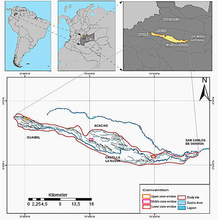
FIGURE 1. Location of the Orotoy river basin and ESPU in upper, middle and lower basin zones windows. Source: Elaborated by the authors.
The ES and indicators selected for this case, from previous thematic studies reported for Orinoquia in general (Osorio, 2014; Lavelle et al., 2014; Rojas Salazar 2017; IAvH et al., 2015; Morinelly, 2015) and from advances in necessary methods for the development of research (Bullock et al., 1985; Jaramillo, 2002) are listed in table 1; For the ecological assessment process, it was started from the ES identified as priority, due to their critical condition and the perception of local stakeholders: determination of the water supply in the soil, carbon storage and water regulation (Caro-Caro et al., 2011, IAvH, 2015a, IAvH, 2015b).
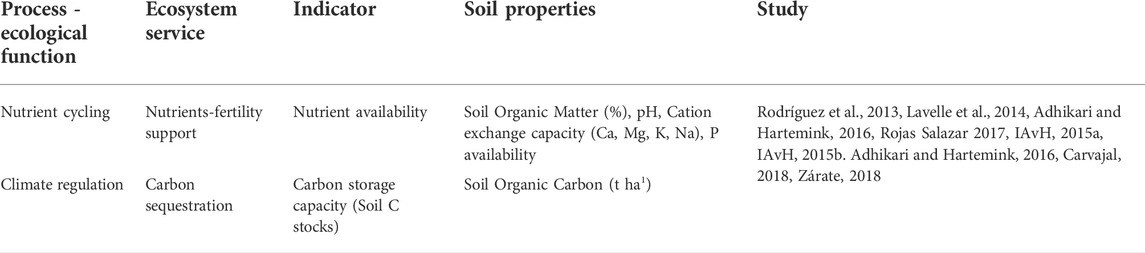
TABLE 1. Relationship of ecosystem services with their indicators and previous study sources. Orotoy river basin. Source: Elaborated by the authors.
The following criteria for the selection for study windows of 70 ha were applied: the change in land cover from 1986, 2000, and 2014 (Carvajal, 2015) and the analysis of available satellite images based on a Google Earth query in coverage, year 2014 (upper zone) and 2015 (middle and lower zones); the inclusion of the altitudinal gradient from the upper part to the lower part (Caro-Caro et al., 2011); the presence of landscape mosaics made up of tropical humid forest (persistent at least since 1986), Oil Palm Plantation and grasslands (with permanent lots of more than 20 years), and lotic systems; the guarantee of disposition of minimum cartographic units; and the record of access conditions for the collection of primary information and collection of samples. The field work was carried out from May to December 2016, during the rainy season (May to November) and the beginning of the dry season (December). The transects defined for each window and the way in which the 896 soil samples were collected in the field are illustrated in Figure 2. A total amount of 180 soil samples were collected; three replicates came from each transect, at depths of 0–10 cm and 10–20 cm. Seventeen (17) transects defined for the mosaics of each window is illustrated in Figures 2A,B. Samples were collected using a stainless-steel hand auger and stored in labeled polyethylene bags until transport to the Unillanos’ soil analysis laboratory. Undisturbed soil samples were also taken with cylinders 5 cm high × 5 cm in diameter at depths of 0–10 cm and 10–20 cm in each transect to determine porosity (real and bulk density). (Grimaldi et al., 2014).
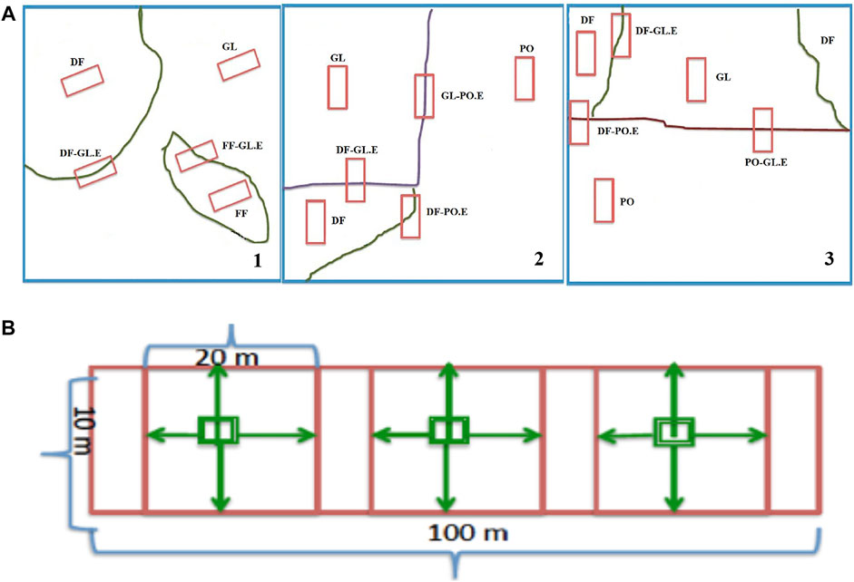
FIGURE 2. (A) Transects location within and between the landscape mosaic in the Orotoy river basin. Red squares represent transect within sampling area  . 1) Upper window zone. 2) Middle window zone. 3) Lower window zone. FF, Fragmented Forest; DF, Tropical Dense Humid Forest; GL, Cattle Grassland; OP, Oil Palm Plantation. E, Ecotone transect. Source: Elaborated by the authors. (B) Diagram of the sampling units: transect (100 m × 10 m) with three plots (20 m × 10 m). In green the systematic soil sampling is indicated. Orotoy river basin.
The pH values were measured with a potentiometer in a 1:1 soil: water mix. Organic matter content (OM) was determined by the Walkley–Black method, as described by Jackson (1967); available phosphorus was determined by the Bray II method; and particle size distributions were determined by the hydrometer method (Bouyoucus, 1951). The exchangeable bases potassium (K+), magnesium (Mg2+), sodium (Na+), and calcium (Ca2+), were analyzed after extraction using 1 M ammonium acetate at pH 7.0; Ca2+ and Mg2+ in the extracts were analyzed using an atomic absorption spectrophotometer, whereas Na+ and K+ were determined by fame photometry. Exchangeable acidity and interchangeable aluminum were determined by the KCl method (extraction with 1 N KCl), and efective cation exchange capacity (eCEC) was determined by mathematical calculations (IGAC, 2006). The quality control chemicals and solutions were of analytical standard book reagent grade and was assured using duplicates at the lab level. Bulk density using the cylinder method (Blake and Hartge, 1986) and then drying at 105°C for 48 h (Doran and Mielke, 1984).
Data analysis
The methods on which this study was based correspond to the estimation of an indicator of an ecosystem service, in this case the indicator of the ecosystem service of fertility, from the physical (clay) chemical variables (pH; interchangeable bases, CEC, P) statistically analyzed using the principal component analysis. Statistical analyses were performed in the R software environment (v.3.6.1; R Development Core Team, 2019) with the ade4 Package. An initial principal component analysis (PCA) allows for identification of the variables that best discriminate among the different windows, land cover and transects. Variables with significant contribution (>50% of the maximum value) to either of the first two principal component axes were selected and their contribution to PCA axes 1 and 2 multiplied by the overall variability explained by each PCA axis in order to generate a weight factor for each variable. Values for each variable were then multiplied by their corresponding weight factor and summed to generate a raw sub-indicator value using the following formula described by Lavelle et al. (2014).
Ii1 = F1 × (αIa + βIb + γIc· · ·) + F2 × (αIIa + βIIb + γIIc· · ·)
Ii1 = value of the ecosystem service indicator at point 1 (window, coverage, transect).
F1 = % of the value of the variance explained by axis 1 of the PCA.
αI, βI, γI = respective contributions of variables a, b, c to the factor I.
a, b, c = values of the variables measured at the point 1.
Analysis of variance was performed to compare indicators across windows and transects and Tukey´s test was applied with significant level of α = 0.05.
Results
Ecosystem Service soil fertility associated with variables of organic matter and cation exchange capacity
From the PCA, the first two components were choose, with weights explaining total variance of 31.4% and 20.4%, respectively (Figure 3). The most important soil properties explaining the variance of the data were the Organic Matter (OM) and Cation Exchange Capacity (CEC), thus they were selected for estimating the nutrient availability indicator, in the ESPU. The PCA allowed to establish that in the windows zone two groups were differentiated: one for the upper zone and another formed by the middle and the lower zones. In terms of transects those corresponded to the Fragmented Forest (FF) and the Fragmented Forest-Grassland Transition (FFGL) ecotone clearly separated, standing out in the whole set the transect of the Oil Palm Dense Forest Transition (OPDF) ecotone (Figure 4).
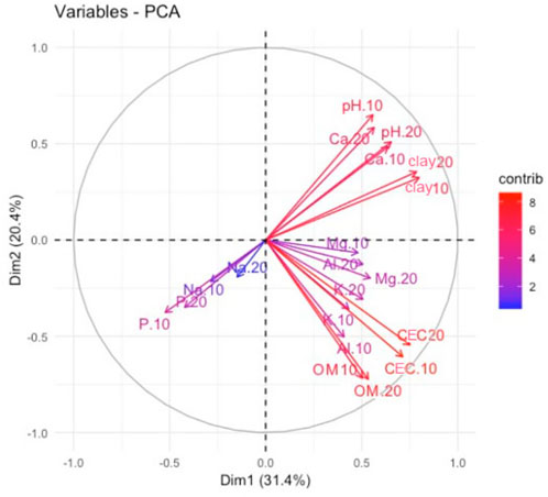
FIGURE 3. Correlation circle with all the chemical variables and clay content to build the soil fertility ES valuation indicator. Orotoy river basin.
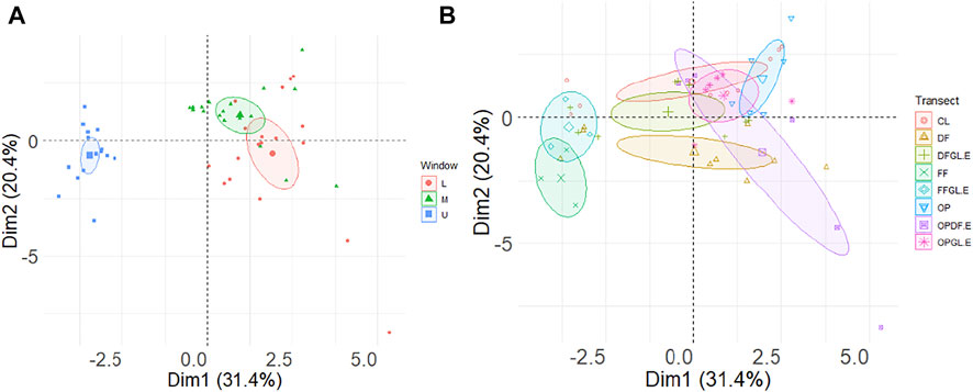
FIGURE 4. Analysis of Principal Components for ESPU, soil ES indicator of nutrient availability. (A). Window. (B). Transect. Orotoy river basin. FF, Fragmented Forest; DF, Tropical Dense Humid Forest; GL, Cattle Grassland; OP, Oil Palm Plantation. DFGL.E, ecotone DF-GL; OPDF.E, ecotone OP-DF; OPGL.E, ecotone OP-GL; FFGL.E, ecotone FF-GL. Source: Elaborated by the authors.
The ANOVA showed a highly significant difference between windows (Table 2), where two transects of the remaining group are also separated: the FFGL ecotones (lower value) and the OPDF (highest value). The highest values of the nutrient availability indicator were found in the transects where the oil palm plantation was located, the lowest values in the dense forest and the pastures that have not been fertilized (Figure 5).

TABLE 2. ANOVA for ESPU of the nutrient availability indicator. α = 0.05. Orotoy river basin. Source: Elaborated by the authors.
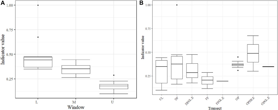
FIGURE 5. Soil ES indicator of fertility ESPU. (A). Window. (B). Transects. Orotoy river basin. FF, Fragmented Forest; DF, Tropical Dense Humid Forest; GL, Cattle Grassland; OP, Oil Palm Plantation. DFGL.E, ecotone DF-GL; OPDF.E, ecotone DF-OP; OPGL.E, ecotone OP-GL; FFGL.E, ecotone FF-GL. Source: Elaborated by the authors.
Ecosystem service carbon storage in soil associated with organic matter
In the determination of the carbon stock with the variables apparent density and organic matter (%), for the depth of 0–10 cm, the indicator of the ES carbon storage for the ESPU varied significantly between windows, with a more high value for the window of the lower zone, while the land cover with the highest value was that of the OPDF ecotone and the lowest was the FFGL ecotone (Figure 6; Table 3).

FIGURE 6. Soil ES valuation indicator, Carbon storage, for ESPUs. (A). Window. (B). Transects. Orotoy river. FF, Fragmented Forest; DF, Tropical Dense Humid Forest; GL, Cattle Grassland; OP, Oil Palm Plantation. DFGL.E, ecotone DF-GL; OPDF.E, ecotone DF-OP; OPGL.E, ecotone OP-GL; FFGL.E, ecotone FF-GL basin. Source: Elaborated by the authors.
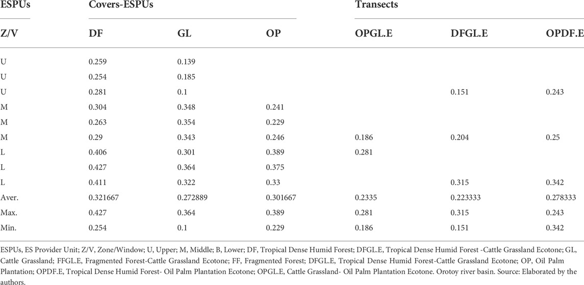
TABLE 3. ES indicator estimation of the soil carbon storage.
Table 3 shows that the highest mean values of the carbon stock indicator were obtained by the forest cover and the transect corresponding to the ecotone between the DF and the Oil Palm- OP. On the other hand, the mean comparison of the soil carbon storage indicator separated the ESPs windows into two groups: upper and medium in one, and in the other hand, lower.
Discussion
Some disadvantages of ecological evaluation focused solely on the condition of the habitat are covered, as Postchin and Haines-Young (2013) expressed. The importance of ecologically valuing soil ES is inferred, an aspect that several authors recently pointed out (Adhikari and Hartemink, 2016; Jónsson and Davíðsdóttir, 2016; Jónsson et al., 2017) at detailed scale (1:25.000) from the multifunctional approach to the landscape, as a strategy to support land use planning and management in a specific area or object of study. Likewise, Dale and Polanski (2007) expressed that the set of ES, measured by ecological indicators, can increase the value of agricultural lands under alternative management in contrast to the current management.
Ecosystem Service of nutrient supply (fertility): Indicator of nutrient availability
As a general trend, the higher value of the ES fertility indicator, associated with OM, clays and CEC, in the ESPU middle and lower zones of the basin, can be explained by erosive processes that move these particles from the upper zone and concentrate them in the other two zones (Figure 7); in the same way, anthropic contributions fertilization practices in mosaic agroecosystems, especially in OP crops - increase this indicator, due to runoff, by adding bases (Mg+ y K+ cations), those that consequently favor accumulation in the lower zone; Added to this is the phenomenon of washing to overflow events of the water courses (channels) that contribute with silts and clays sediments raising the value of the indicator of this ES, mainly in the lower zone.

FIGURE 7. Orotoy river basin: 1: 25,000 cartographic representation of the soil ES assessment indicator “storage capacity of nutrients and organic matter.” for ESPUs Window and Coverages. Arrows indicate trade-offs and the direction of their flow. Source: Elaborated by the authors.
Anderson-Teixeira and DeLucia (2011) state that the forests that host the greatest amount of carbon are the humid tropical ones that grow on periodically flooded soils. This pattern was registered in the same way in the soils of the forests studied in the Orotoy basin, regardless of its location in the different zones, although with lower values for the upper zone.
The lowest ES of soil fertility was found in the upper zone in the FFGL ecotone and the highest was found in the middle and lower zones in the OPDF ecotone. Those values are explained by how much more organic matter accumulates in the latter. Quantity of organic matter come from two main sources: Forest biomass associated with the processes and functions of soil maintenance and the contributions of the cultural management of OP cultivation: application of bases (K+, Mg++) that come by runoff and are retained, allowing a greater accumulation of organic matter in the soil and therefore an increase in the cation exchange capacity.
Another important factor in understanding soil ES in terms of nutrient provision, via organic matter and productivity, is the community of soil organisms, since they directly impact cultivation yields and indirectly via nutrient cycles - food chains and modification of the soil structure (Barrios, 2007). In the Orotoy basin, Morinelly (2016), reported the Acarí class and the Entomobryidae, Formicidae and Termitidae families, as the most abundant, while the highest values of indices of richness, abundance, diversity and dominance were the ESPs tropical humid forest (gallery forest) of the lower zone and for the fairness index the highest value was from the grassland ESPs (open). Thus, it is possible to highlight the functional importance of biological communities in the soil and in turn, the role of the soil in the conservation of biodiversity (Lo-Man-Hung et al., 2011; Pulleman et al., 2012).
The fertility of the landscape mosaic in the Orotoy basin depends on the parental material characterized by a low supply of nutrients, as evidenced in the ES values reported for the forests, mainly in the upper zone; In contrast, in other zones, fertility is improved with the contributions of agroecosystems; trade-offs occur from the ESPUs cultivation of PO and GL towards the DF, via runoff (contributions of clays, organic matter increased by cultural management) which appears to increase the ES of water storage and fertility. As Viglizzo and Roberto (1998), Viglizzo et al. (2012) stated, resolving the trade-offs between productivity, stability and sustainability is a central issue in agroecology; in this aspect, Howe et al. (2014) explained the importance of achieving synergies resulting from trade-offs, while Viglizzo et al. (2012) and O´Sullivan et al. (2015) expressed the need to develop agri-environmental policies that recognize ES and trade-offs for the sake of environmental governance.
The ES provision of soil nutrients is related to biodiversity, the capacity to capture, retain and transport water or carbon, and is largely determined by the capacity of each soil to form and decompose organic matter (Victoria et al., 2012), as established in each ESPU.
Regulatory ecosystem service: Soil carbon storage associated with organic matter: Carbon storage capacity indicator
Different studies highlight the role of soils in atmospheric carbon sequestration (Lal, 2004; Franzluebbers, 2005; Buckingham, 2014); carbon sequestration provides benefits to maintain soil quality, such as the aforementioned water storage capacity and fertility, measured as indicators of soil ES; It also allows the soil to become a storehouse of the geological and archaeological heritage of the planet (Marks et al., 2009).
In general, soil scientists recognize the importance of soil organic matter, quantity and dynamics, as a key factor that affects the soil’s ability to provide services to agriculture, environment, and human communities at both local scales (maintenance of fertility for example) and global scales (mitigation of carbon emissions into the atmosphere) (Lal, 2004; Marks et al., 2009; Powlson et al., 2011; Buckingham, 2014; McBratney et al., 2014; Adhikari and Hartemink, 2016; Calzolari et al., 2016). The rational management of multifunctional landscapes is important as support in the definition of climate change mitigation strategies based on the evaluation of their ecosystem services, including carbon storage, and the spatio-temporal interactions that characterize them, as stated by, Hao et al. (2017).
In the ESPUs zones of the basin, the highest value of the carbon stock ES indicator was obtained in the lower zone, consistent with the geomorphological conditions of the foothill landscape, with alluvial plain and meander valley at this altitude (300 masl) and Typic Hapludox soil (75%). This zone receives contributions from the runoff (sediments, organic matter) from the upper part, and eventually has effects of flood dynamics due to overflow of channels, in addition to having anthropic input of nutrients by fertilization. As Morison et al. (2012) stated, variables such as forest age, elevation, species composition and soil management can influence the ability of a habitat to store carbon.
In the ESPs coverage (ecosystems), the highest average value of the carbon stock indicator obtained for the tropical humid forest (0.321), coincides as a trend with that reported by Ibrahim et al. (2007) for Colombia in the riparian forests on Andisol-type soils older than 20 years determined at 1 m depth by Moreno and Lara (2003) for intervened primary and secondary forests. While the lowest average value of this indicator for grassland cover (0.27), contrasts with that expressed by Ibrahim et al. (2007), the soil organic carbon storage pattern, in different uses, shows lower amounts in soils of advanced secondary forests and riparian forests than in grassland soils.
The organic carbon storage capacity of soil is related to the use and methods of tillage (DeFries et al., 2004; IgAC, 2006), and with deforestation and selective logging (Asner et al., 2010; Edwards et al., 2014). Regarding the formation of organic matter in Lithic Eutropept soil of foothill plains, Zárate (2018) reported the highest value of fixation, from 291.4 to 336.8 tons of CO2 ha−1, for the treatment with natural cover, concluding that the strategy of the use of vegetation ground cover is a viable measure to help mitigate climate change.
The higher value of the ES of carbon stock, obtained in the transitional palm-forest cultivation cover in the middle and low zones, can be explained from what is stated by Dale and Polanski (2007): “different forms of carbon sequestration and other environmental benefits accrue to the rows of annuals, perennials or animal husbandry ”and the ES trade-offs that allow the flow of ES from the upper to the lower zone, together with the location of forests in the windows of the basin, since the biophysical conditions in which they are located also contribute to their ability to offer ES (Maass et al., 2002). However, authors like Andrade-Castañeda et al. (2016), did not find significant differences between the ecotones agroecosystems-tropical dry forest, with records of average carbon storage 65.6 t C/ha (rice crop-riparian forest) and 61.3 t C/ha (grassland-riparian forest) at 20 cm depth.
In general for the Orotoy river basin, at a scale of 1: 100,000, local communities have identified trade-offs of the different systems (natural and transformed), from the provision of water and carbon storage in the riparian forests (Caro-Caro et al., 2011) even those provided by productive agroecosystems that generate employment and economic benefits (Osorio and Bogota, 2014; Guzmán, 2016) and cultural services (Zabala-Forero and Victorino, 2019) but they affect the ES provision and quality of the water resource (Rincón-Ruiz et al., 2016a, Rincón-Ruiz et al., 2016b; Lara, 2017; Victorino and Lara, 2017). However, it is important to specify that the dynamics of trade-offs depend on the scale that is the object of research (Laterra et al., 2012; Alarcon et al., 2015), argument that can be demonstrated in this study, where the level of detail makes it possible to establish trade-offs between natural and transformed covers in geormorphological conditions and agricultural management of the basin that favor trade-offs from agroecosystems to tropical humid forests (fertility and carbon stock indicators). Likewise, Budiharta et al. (2018) mention the importance of maintaining tropical forest areas as an alternative for carbon restoration and storage, in zones where there were OP crops, while Harmácková and Vacká (2015) concluded about the importance of “compensation in terms of ES regulation” for decisions in landscapes that need to be conserved.
Conclusion
It was possible to establish that in each ESPU the overall fertility of the landscape mosaic in the Orotoy basin depended on the parental material characterized by a low supply of nutrients.
The ES of the mosaics of multifunctional landscapes were related to the soil forming factors vegetation cover, and cultural practices; these determined trade-offs between ES.
The evaluation of the ES at multifunctional landscape level allowed to understand synergy between the different ESPU and the possible impacts in ES to nutrient provision and sustainability.
The valuation of soil ES allowed to recognize the importance of the mosaics of natural and transformed systems as part of the landscape and the trade-offs that occur between its ESPUs.
The soil ES presented as ecological indicators for nutrient supply and carbon storage in tropical forest, grassland and oil palm agroecosystems provide key information for management alternatives under scenarios of climatic changes.
Data availability statement
The raw data supporting the conclusions of this article will be made available by the authors, without undue reservation.
Author contributions
CC-C Question statement, gathering of primary information, processing and analysis of laboratory and data series, preparation of the paper, JB-R selection and analysis of indicators with a landscape approach, analysis and adjustment of the paper, MA-A processing and analysis of indicators, processing and statistical analysis of data, adjustment of paper, MT-M landscape approach, methodological adjustment and adjustment of the paper.
Funding
To the financial contribution of the agreement 15-13-165-125CE Universidad de los Llanos (Unillanos) - Alexander von Humboldt Biological Resources Research Institute (IAvH), within the framework of the project “Strengthening the capacities for social and ecological adaptation to climate change in the river basin Orotoy River, Colombia.” To Institute of Environmental Sciences of the Colombian Orinoquia and General Directorate of Investigations of Unillanos by financial contribution of the research project “Comprehensive valuation of ecosystem services of humid tropical forests and agroecosystems of grassland and oil palm (Elaeis sp.) as a strategy territorial management of landscapes in the River basin Orotoy, Colombian Orinoquia.”
Acknowledgments
To the communities, farmers and peasants of the basin Orotoy, to the work groups in the field and laboratory of Unillanos and Agrosavia; for their support in the cartographic processes to Óscar Díaz Celis and Leonardo Gutiérrez. To Yenny Estupiñán by graphic editing.
Conflict of interest
The authors declare that the research was conducted in the absence of any commercial or financial relationships that could be construed as a potential conflict of interest.
Publisher’s note
All claims expressed in this article are solely those of the authors and do not necessarily represent those of their affiliated organizations, or those of the publisher, the editors and the reviewers. Any product that may be evaluated in this article, or claim that may be made by its manufacturer, is not guaranteed or endorsed by the publisher.
References
Adhikari, K., and Hartemink, A. E. (2016). Linking soils to ecosystem services - a global review. Geoderma 262, 101–111. doi:10.1016/j.geoderma.2015.08.009
Alarcon, G. G., Ayanu, Y., Fantinia, A., Farley, J., Filho, A. S., and Koellner, T. (2015). Weakening the Brazilian legislation for forest conservation has severe impacts for ecosystem services in the Atlantic Southern Forest. Land Use Policy 47, 1–11. doi:10.1016/j.landusepol.2015.03.011
Anderson-Teixeira, K. J., and DeLucia, E. H. (2011). The greenhouse gas value of ecosystems. Glob. Change Biol. 17, 425–438. doi:10.1111/j.1365-2486.2010.02220.x
Andrade, G. I., and Castro, L. G. (2012). Degradación, pérdida y transformación de la biodiversidad continental en Colombia, invitación a una interpretación socioecológica. Ambiente Desarro. XVI 30, 53–71.
Andrade, G. I., Wills, E., Serje, M., Madriñán, S., Romero, M., Delgado, J., et al. (2014). Ecosistema empresarial agroindustrial. Proceso de construcción de un paisaje agroindustrial sostenible en el proyecto Veracruz, frontera agroindustrial de la altillanura en la Orinoquia colombiana. Bogotá: Centro de Estrategia y Competitividad, Universidad de los Andes.
Andrade-Castañeda, H. J., Segura-Madrigal, M. A., and Rojas-Patiño, A. S. (2016). Carbono orgánico del suelo en bosques riparios, arrozales y pasturas en Piedras, Tolima, Colombia. Agron. Mesoam. 27 (2), 233–241. doi:10.15517/am.v27i2.24359
Andrade-Pérez, G. I., Romero, M., and Delgado, J. (2013). Diseño adaptativo de un paisaje agroindustrialUna propuesta para la transformación agrícola de la altillanura colombiana. Ambiente Desarro. 17 (33), 29–40.
Asner, G. P., Powell, G. V. N., Mascaro, J., Knapp, D. E., Clark, J. K., Jacobson, J., et al. (2010). High-resolution forest carbon stocks and emissions in the Amazon. Proc. Natl. Acad. Sci. U. S. A. 107, 16738–16742. doi:10.1073/pnas.1004875107
Barrios, E. (2007). Soil biota, ecosystem services and land productivity. Ecol. Econ. 64 (2), 269–285. doi:10.1016/j.ecolecon.2007.03.004
Blake, G. R., and Hartge, K. H. (1986). “Bulk density,” in Methods of soil analysis. Part 1. Physical and mineralogical methods. Editor A. Klute (Madison, Wisconsin, USA: Am. Soc. Agron. and Soil Sci. Soc. Am.), 363–375.
Bouyoucus, G. I. (1951). A calibration of the hydrometer method for making mechinal analysis of the soils. Agron. J. 4, 9–434.
Buckingham, S. (2014). Ecosystem services and carbon sequestration in the biosphere. By R.lal, K.lorenz, R.F.hüttl, B.U.schneider & J.vonBraun (eds). Published by springer Science+Business media, dordrecht, The Netherlands, (www.Springer.com) 2013. x + 464 p. €160.49; £135; US$. Soil Use Manag. 30 (1), 168–169. doi:10.1111/sum.12087
Budiharta, S., Meijaard, E., Gaveau, D. L. A., Struebig, M. J., Wilting, A., Kramer-Schadt, S., et al. (2018). Restoration to offset the impacts of developments at a landscape scale reveals opportunities, challenges and tough choices. Glob. Environ. Change 52, 152–161. doi:10.1016/j.gloenvcha.2018.07.008
Bullock, P., Fedoroff, N., Jongerious, A., Stoops, G., Tursina, T., and Babel, U. (1985). Handbook for soil thin section description. Volverhampton: Waine Research Publications.
Calzolari, C., Ungaro, F., Filippi, N., Guermandi, M., Malucelli, F., Marchi, N., et al. (2016). A methodological framework to assess the multiple contributions of soils to ecosystem services delivery at regional scale. Geoderma 261, 190–203. doi:10.1016/j.geoderma.2015.07.013
Caro-Caro, C. I., Torres–Mora, M. A., and Ramírez-Gil, H. (2011). Determinación y formulación de las medidas socioambientales asociadas a la recuperación del río Orotoy, en el área de influencia de la Superintendencia de Operaciones Central Ecopetrol, municipios de Acacías y Castilla La Nueva. Villavicencio: Universidad de los Llanos.
Caro-Caro, C. I., and Torres–Mora, M. A. (2015). Servicios ecosistémicos como soporte para la gestión de sistemas socioecológicos: Aplicación en agroecosistemas. Orinoquia 19 (2), 237–252. doi:10.22579/20112629.338
Carvajal, A. F. (2015). Análisis de la transformación del territorio en función de las dinámicas de apropiación y uso del recurso hídrico. Bogotá, D.C. Bogotá: Instituto de Investigación de Recursos Biológicos Alexander von Humboldt.
Carvajal, B. N. (2018). Reservas de carbono en sistemas de uso del suelo del piedemonte, del valle aluvial río Cravo Sur, municipio de Yopal-Casanare. Villavicencio (Meta): Universidad de los Llanos. [Tesis de Maestría]. [Villavicencio (Meta)].
Crossman, N. D., Burkhard, B., Nedkov, S., Willemen, L., Petz, K., Palomo, I., et al. (2013). A blueprint for mapping and modelling ecosystem services. Ecosyst. Serv. 4, 4–14. doi:10.1016/j.ecoser.2013.02.001
Dale, V., and Polansky, S. (2007). Measures of the effects of agricultural practices on ecosystem services. Ecol. Econ. 64, 286–296. doi:10.1016/j.ecolecon.2007.05.009
de Groot, R. S., Alkemade, R., Braat, L., Hein, L., and Willemen, L. (2010). Challenges in integrating the concept of ecosystem services and values in landscape planning, management and decision making. Ecol. Complex. 7, 260–272. doi:10.1016/j.ecocom.2009.10.006
Defries, R. S., Foley, J. A., and Asner, G. P. (2004). Land-use choice: Balancing human needs and ecosystem function. Front. Ecol. Environ. 2 (5), 249–257. doi:10.1890/1540-9295(2004)002[0249:LCBHNA]2.0.CO;2
Domptail, S. E., Nuppenau, E. A., Azebaze, N., Brown, L. D., Falk, T., Finckh, M., et al. (2013). Using trade-offs and synergies in ecosystem services for resource management. Biodivers. Ecol. 5, 185–193. doi:10.7809/b-e.00274
Doran, J. W., and Mielke, L. N. (1984). A rapid, low cost method for determination of soil bulk density. Soil Sci. Soc. Am. J. 48, 717–719. doi:10.2136/sssaj1984.03615995004800040004x
Edwards, D. P., Tobias, J. A., Sheil, D., Meijaard, E., and Laurance, W. F. (2014). Maintaining ecosystem function and services in logged tropical forests. Trends Ecol. Evol. 29 (9), 511–520. doi:10.1016/j.tree.2014.07.003
Franzluebbers, A. J. (2005). Soil organic carbon sequestration and agricultural greenhouse gas emissions in the southeastern USA. Soil Tillage Res. 83 (1), 120–147. doi:10.1016/j.still.2005.02.012
García-Llorente, M., Martín-López, B., Iniesta-Arandia, I., López-Santiago, C. A., Aguilera, P. A., and Montes, C. (2012). The role of multi-functionality in social preferences toward semi-arid rural landscapes: An ecosystem service approach. Environ. Sci. Policy 19, 136–146. doi:10.1016/j.envsci.2012.01.006
Grimaldi, M., Oszwald, J., Dolédec, S., Hurtado, M., de Souza, M. I., De Sartre, X. A., et al. (2014). Ecosystem services of regulation and support in amazonian pioneer fronts: Searching for landscape drivers. Landsc. Ecol. 29 (2), 311–328. doi:10.1007/s10980-013-9981-y
Guzmán, V. y. Castro. L. G. (2016). “Sistemas socioecológicos de la cuenca del Orotoy. Bases para la identificación de gestión territorial,” in Estado y tendencias de la biodiversidad en Colombia”, en Biodiversidad 2016. GI. Andrade y LF Ruíz-Contreras. Editor L. A. Moreno (Bogotá: Editorial Alexander von Humboldt), 409.
Hao, R., Yu, D., Liu, Y., Liu, Y., Qiao, J., Wang, X., et al. (2017). Impacts of changes in climate and landscape pattern on ecosystem services. Sci. Total Environ. 579, 718–728. doi:10.1016/j.scitotenv.2016.11.036
Harmácková, Z., and Vacká, D. (2015). Modelling regulating ecosystem services trade-offs across landscape scenarios in Třeboňsko Wetlands Biosphere Reserve, Czech Republic. Ecol. Model. 295, 207–215. doi:10.1016/j.ecolmodel.2014.10.003
Howe, C., Suich, H., Vira, B., and Mace, G. M. (2014). Creating win-wins from trade-offs? Ecosystem services for human well-being: A meta-analysis of ecosystem service trade-offs and synergies in the real world. Glob. Environ. Change 28, 263–275. doi:10.1016/j.gloenvcha.2014.07.005
IAvH (2014). Fortalecimiento de las capacidades de adaptación social y ecológica al cambio climático en la cuenca hidrográfica del río Orotoy, Colombia. Bogotá, DC: Instituto de Investigación de Recursos Biológicos Alexander von Humboldt.
IAvH (2015a). Fortalecimiento de las capacidades de adaptación social y ecológica al cambio climático en la cuenca hidrográfica del río Orotoy, Colombia. Bogotá, DC: Instituto de Investigación de Recursos Biológicos Alexander von Humboldt.
IAvH (2015b). Oferta y demanda de servicios ecosistémicos como indicadores de sostenibilidad en agroecosistemas de la Altillanura colombiana Fase II. Bogotá, D.C. Bogotá: Instituto de Investigación de Recursos Biológicos Alexander von Humboldt. Cormacarena y Corpoica.
Ibrahim, M., Chacón, M., Cuartas, C., Naranjo, J., Ponce, G., Vega, P., et al. (2007). Almacenamiento de carbono en el suelo y la biomasa arbórea en sistemas de uso de la tierra en paisajes ganaderos de Colombia, Costa Rica y Nicaragua. Agroforestería las Américas 47, 27–36.
IGAC (Instituto Geográfico Agustín Codazzi) (2006). Métodos analíticos del laboratorio de suelos. VI Edición. Bogotá: IGAC Subdirección de Agrología, 499.
Intergovernmental Panel on Climate Change - IPCC (2006). IPCC guidelines for national greenhouse gas inventories. Hayama: Institute for Global Environmental Strategies IGES.
Jaramillo, D. (2002). Introducción a la ciencia del suelo. Medellín: Universidad Nacional de Colombia.
Jónsson, J. Ö. G., and Davíðsdóttir, B. (2016). Classification and valuation of soil ecosystem services. Agric. Syst. 145, 24–38. doi:10.1016/j.agsy.2016.02.010
Jónsson, J. Ö. G., Davíðsdóttir, B., and Nikolaidis, N. P. (2017). Valuation of soil ecosystem services. Adv. Agron. 142, 353–384. doi:10.1016/bs.agron.2016.10.011
Lal, R. (2004). Soil carbon sequestration impacts on global climate change and food security. Science 304, 56771623–56771627. doi:10.1126/science.1097396
Lara, D. (2017). Valoración integral de biodiversidad y servicios ecosistémicos de la cuenca del Orotoy”, en Preguntas y Respuestas sobre conflictos ambientales. Aprendizajes del río Orotoy. LG Castro: Bogotá, editorial Alexander von Humboldt, 60–67.
Laterra, P. (2013). Evaluación y mapeo de servicios ecosistémicos. Retos para la gestión territorial en América Latina. Bogotá: Instituto de Investigación de Recursos Biológicos Alexander von Humboldt – Universidad de los Andes. [Disertación]. [Bogotá, D.C.].
Laterra, P., Jobbágy, E., and Paruelo, J. (2011). Valoración de servicios ecosistémicos Conceptos, herramientas y aplicaciones para el ordenamiento territorial. Buenos Aires: Ediciones INTA.
Laterra, P., Orúe, M. E., and Booman, G. C. (2012). Spatial complexity and ecosystem services in rural landscapes. Agric. Ecosyst. Environ. 154, 56–67. doi:10.1016/j.agee.2011.05.013
Lavelle, P., Rodríguez, N., Arguello, O., Bernal, J., Botero, C., Chaparro, P., et al. (2014). Soil ecosystem services and land use in the rapidly changing Orinoco River Basin of Colombia. Agric. Ecosyst. Environ. 185, 106–117. doi:10.1016/j.agee.2013.12.020
Lo-Man-Hung, N. F., Marichal, R., Candiani, D. F., Carvalho, L. S., Indicatti, R. P., Bonaldo, A. B., et al. (2011). Impact of different land management on soil spiders (Arachnida: Araneae) in two Amazonian areas of Brazil and Colombia. J. Arachnol. 39, 296–302. doi:10.1636/CP10-89.1
Maass, J. M., Jaramillo, V., Martínez-Yrízar, A., García-Oliva, F., Pérez-Jiménez, L. A., and Sarukhán, J. (2002). in Aspectos funcionales del ecosistema de selva baja caducifolia en Chamela, Jalisco”, enHistoria Natural de Chamela. Editors J. H. Vega FA Noguera, A. N. García-Aldrete, M. Quesada, and D. F. México (México, DF: Instituto de Biología, UNAM), 525–542.
Malinga, R., Gordon, L. J., Jewitt, G., and Lindborg, R. (2015). Mapping ecosystem services across scales and continents–A review. Ecosyst. Serv. 13, 57–63. doi:10.1016/j.ecoser.2015.01.006
Marks, E., Aflakpui, G. K. S., Nkem, J., Poch, R. M., Khouma, M., Kokou, K., et al. (2009). Conservation of soil organic carbon, biodiversity and the provision of other ecosystem services along climatic gradients in West Africa. Biogeosciences 6 (8), 1825–1838. doi:10.5194/bg-6-1825-2009
Mastrangelo, M. E., Weyland, F., Herrera, L. P., Villarino, S. H., Barral, M. P., and Auer, A. D. (2015). Ecosystem services research in contrasting socio-ecological contexts of Argentina: Critical assessment and future directions. Ecosyst. Serv. 16, 63–73. doi:10.1016/j.ecoser.2015.10.001
McBratney, A. B., Field, D. J., and Koch, A. (2014). The dimensions of soil security. Geoderma 213, 203–213. doi:10.1016/j.geoderma.2013.08.013
Moreno, F., and Lara, W. (2003). in Variación del carbono orgánico del suelo en bosques primarios intervenidos y secundarios”, en Medición de la captura de carbono en ecosistemas forestales tropicales de Colombia, contribuciones para la mitigación del cambio climático. Editors S. A. Orrego, J. I. Del Valle, and D. C. FH Moreno (Bogotá (Bogotá: Universidad Nacional de Colombia-Centro Andino para la Economía del Medio Ambiente CAEMA). 189–213.
Morinelly, D. (2015). Valoración ecológica de servicios ecosistémicos para la cuenca del río Orotoy. Bogotá: Instituto de Investigación de Recursos Biológicos Alexander von Humboldt, 48–54.
Morinelly, D. (2016). Valoración ecológica de servicios ecosistémicos para la cuenca del río Orotoy. Bogotá: Instituto de Investigación de Recursos Biológicos Alexander von Humboldt, 28–47.
Morison, J., Matthews, R., Miller, G., Perks, M., Randle, T., Vanguelova, E., et al. (2012). Understanding the carbon and greenhouse gas balance of forests in Britain. Abstract retrieved from cabdirect. (Accession No. 20123346717)
Nahuelhual, L., Laterra, P., Villarino, S., Mastrangelo, M., Carmona, A., Jaramillo, A., et al. (2015). Mapping of ecosystem services: Missing links between purposes and procedures. Ecosyst. Serv. 13, 162–172. doi:10.1016/j.ecoser.2015.03.005
O'Sullivan, L. R., Creamer, E., Fealy, R., Lanigan, G., Simo, I., Fenton, O., et al. (2015). Functional land management for managing soil functions: A case-study of the trade-off between primary productivity and carbon storage in response to the intervention of drainage systems in Ireland. Land Use Policy 47, 42–54. doi:10.1016/j.landusepol.2015.03.007
Osorio, D. P., and Bogotá, D. C. (2014). Caracterización de los sistemas socioecológicos de la cuenca Orotoy. Bogotá: Instituto de Investigación de Recursos Biológicos Alexander von Humboldt, 35–40.
Potschin, M., and Haines-Young, R. (2013). Landscapes, sustainability and the place-based analysis of ecosystem services. Landsc. Ecol. 28, 1053–1065. doi:10.1007/s10980-012-9756-x
Powlson, D. S., Gregory, P. J., Whalley, W. R., Quinton, J. N., Hopkins, D. W., Whitmore, A. P., et al. (2011). Soil management in relation to sustainable agriculture and ecosystem services. Food Policy 36, S72–S87. doi:10.1016/j.foodpol.2010.11.025
Pulleman, M., Creamer, R., Hamer, U., Helder, J., Pelosi, C., Pérès, G., et al. (2012). Soil biodiversity, biological indicators and soil ecosystem services-an overview of European approaches. Curr. Opin. Environ. Sustain. 4 (5), 529–538. doi:10.1016/j.cosust.2012.10.009
Rincón-Ruiz, A., Lara, D., and Castro, L. G. (2016a). “Inclusión de valores y conflicto ambiental en la cuenca del Orotoy. Propuesta para promover una gobernanza con visión social y ecológica,” in En Biodiversidad 2015. Estado y tendencias de la biodiversidad continental de Colombia. Editors M. F. Gómez, L. A. Moreno, G. I. Andrade, and C. Rueda (Bogotá: Editorial Alexander von Humboldt), 401.
Rincón-Ruiz, A., Lara, D., Castro, L. G., and Rojas, C. (2016b). Conflictos socioambientales y servicios ecosistémicos en la cuenca del río Orotoy: Reflexiones para su gestión. Ambiente Sostenibilidad (6), 3–16.
Rodríguez, N. S., Lavelle, P., Pulido, S. X., Gutiérrez, A. J., Bernal, J. H., Argüello Tovar, O., et al. (2013). Construcción de indicadores de ecoeficiencia para la altillanura plana en los municipios de Puerto López y Puerto Gaitán, departamento del Meta. Villavicencio: CORPOICA.
Rojas Salazar, L. E. (2017). Documento con las sugerencias para complementar el documento síntesis publicable de la caracterización de la oferta de servicios ecosistémicos asociados a regulación hídrica, ciclaje de nutrientes y captura de carbono, en ecosistemas transformados y naturales de la cuenca hidrográfica del río Orotoy a partir del análisis de viabilidad desarrollado en el presente. Bogotá: Instituto de Investigación de Recursos Biológicos Alexander von Humboldt, 6–13.
Sanabria, C., Lavelle, P., and Fonte, S. J. (2014). Ants as indicators of soil-based ecosystem services in agroecosystems of the Colombian Llanos. Appl. Soil Ecol. 84, 24–30. doi:10.1016/j.apsoil.2014.07.001
Santacruz, A. M. (2010). Diseño de redes de muestreo óptimas para el monitoreo del Carbono Orgánico del Suelo en el C.I. La Libertad mediante la aplicación de algoritmos genéticos. Bogotá: Universidad Nacional de Colombia - Instituto Geográfico Agustín Codazzi. [Disertación/Tesis de Maestría]. [Bogotá, D.C.].
Syrbe, R. U., and Walz, U. (2012). Spatial indicators for the assessment of ecosystem services: Providing, benefiting and connecting areas and landscape metrics. Ecol. Indic. 21, 80–88. doi:10.1016/j.ecolind.2012.02.013
Victoria, R., Banwart, S. A., Black, H., Ingram, H., Joosten, H., Milne, E., et al. (2012). The benefits of soil carbon”, en UNEP Year Book 2012: Emerging Issues in Our Global Environment. Nairobi: UNEP Yearbook, 19–33.
Victorino, I., Castro, L. G., Zabala-Forero, F. A., Caro-Caro, C. I., and Bogota, D. C. (2017). La Cuenca del río Orotoy: Conocimientos para la gestión territorial. Colombia: Instituto de Investigación de Recursos Biológicos Alexander von Humboldt.
Victorino, I., and Lara, D. (2017). “Orotoy, una historia tras los conflictos ambientales,” in En Preguntas y Respuestas sobre conflictos ambientales. Aprendizajes del río Orotoy. Editor L. G. Castro (Bogotá, DC: Editorial Alexander von Humboldt), 32–37.
Viglizzo, E. F., Paruelo, J. M., Laterra, P., and Jobbágy, E. G. (2012). Ecosystem service evaluation to support land-use policy. Agric. Ecosyst. Environ. 154, 78–84. doi:10.1016/j.agee.2011.07.007
Viglizzo, E. F., and Roberto, Z. E. (1998). On trade-offs in low-input agroecosystems. Agric. Syst. 56 (2), 253–264. doi:10.1016/s0308-521x(97)00040-1
Zabala-Forero, A., and y Victorino, I. (2019). Capacidad adaptativa y vulnerabilidad de la cuenca del río Orotoy ante el cambio climático, a partir del análisis de las variables de los medios de vida. Biodivers. Práctica 4 (1), 51–85.
Keywords: socio-ecosystems, valuation, ecosystem service provider units, piedmont, tropical ecosystems
Citation: Caro-Caro CI, Bernal-Riobo JH, Arango-Argoti M and Torres-Mora MA (2022) Tradeoffs between units providing soil ecosystem services in multifunctional landscapes of the Orinoquia. Front. Environ. Sci. 10:675195. doi: 10.3389/fenvs.2022.675195
Received: 02 March 2021; Accepted: 08 September 2022;
Published: 29 September 2022.
Edited by:
Salvador García-Ayllón Veintimilla, Technical University of cartagena, SpainReviewed by:
Cristina Cruz, University of Lisbon, PortugalMaria Amélia Martins-Loução, University of Lisbon, Portugal
Copyright © 2022 Caro-Caro, Bernal-Riobo, Arango-Argoti and Torres-Mora. This is an open-access article distributed under the terms of the Creative Commons Attribution License (CC BY). The use, distribution or reproduction in other forums is permitted, provided the original author(s) and the copyright owner(s) are credited and that the original publication in this journal is cited, in accordance with accepted academic practice. No use, distribution or reproduction is permitted which does not comply with these terms.
*Correspondence: Clara Inés Caro-Caro, Y2xhcmFpbmVzY2Fyb0B1bmlsbGFub3MuZWR1LmNv