 Qiongyao Ruan
 Wenda Li
 Shanghong Zhang
95% of researchers rate our articles as excellent or good
Learn more about the work of our research integrity team to safeguard the quality of each article we publish.
Find out more
ORIGINAL RESEARCH article
Front. Environ. Sci. , 13 January 2023
Sec. Freshwater Science
Volume 10 - 2022 | https://doi.org/10.3389/fenvs.2022.1114448
This article is part of the Research Topic Hydrodynamic Characteristics and Pollutant Transport in Rivers and Nearshore Environments View all 10 articles
The construction of dams changes the natural flow of rivers, affects the integrity of river ecosystems, and causes a series of ecological and environmental problems, such as habitat fragmentation and reduction in fish resources. This study took a section of the Yellow River in China from the Xiaolangdi Dam to Gaocun as the research area. The Yellow River carp (Cyprinus carpio) was selected as an indicator species for its economic value. A habitat suitability model for the Yellow River carp coupled with a one-dimensional hydrodynamic model was built. It was used to simulate dynamic changes in the reproductive habitat suitability of the Yellow River carp before and after the construction of the Xiaolangdi Dam. We demonstrated the spatial distribution of the carp’s spawning reaches before and after the Xiaolangdi Dam construction and investigated its influence on the spawning activity and larval development of the species accordingly. The results apparently showed that the construction and operation of the Xiaolangdi Dam delayed the breeding time of the Yellow River carp and decreased its quality by 5.28%. In particular, the larval fish development was greatly affected by the dam, with the quality being reduced by 8.95%. Furthermore, the habitat suitability of the spawning reaches slightly decreased as the extent of spawning reaches decreased by 16.23%, and several spawning reaches were lost entirely. This study shed light on the response of the Yellow River carp to hydrological and physical changes in the period 1980–1990 before the construction of the Xiaolangdi Dam and 2006–2018 after the construction. Thus, it is a valuable reference for the ecological scheduling of discharges of the Xiaolangdi Dam.
The construction of dams brings great social and economic benefits to human beings but strongly interferes with river ecosystems, resulting in a variety of ecological problems (Liu et al., 2013). Dams as obstructions on rivers, to a certain extent, change the hydrological conditions and impact the environmental geology and biodiversity of rivers (Collier et al., 1996; Fantin-Cruz et al., 2015; Wang et al., 2016). Up to 60% of river habitats worldwide might be affected by dams, disrupting fish migration, fragmenting, or even disappearing aquatic habitats (Morita and Yamamoto, 2002; Yi et al., 2014). Investigating the ecological effects of dams helps protect the river ecosystem, guide the ecological scheduling at the macro level, and achieve a balance between development and ecological protection.
Fish are top aquatic food chain animals in freshwater river basins (Muñoz-Mas et al., 2012) yet sensitive to environmental changes. Individual aquatic species are taken as an indicator of the physical and biological environment of rivers (Karr, 1981) and play an important role in ecosystems (Sun and Sheng, 2000). The Yellow River carp (Cyprinus carpio) inhabits mainly in the Ning–Meng section, Xiaobei mainstream, and the lower reaches of the Yellow River; meanwhile, it is an economically important species of the Yellow River. However, since the 1950s, due to human activities, climate change, and other factors, the natural spawning grounds of fish have been disconnected, and the migration channels have been blocked, which seriously damaged the ecological balance of the Yellow River. By 2008, the total number of fish species recorded in the Yellow River had decreased by 71.72% (Han et al., 2013). Biodiversity loss and ecology destruction can seriously endanger sustainable development, economy, and environmental functions. The scale and quantity of the fish habitat is important to the ecosystem and the high-quality development of the Yellow River Basin. Fish habitat assessment helps understand the impact of dam construction on carp reproduction in the Yellow River. Furthermore, it makes a potential contribution to the restoration of the fish habitat, ecological quality, and biodiversity in the Yellow River Basin.
Hydrological and habitat simulations are mainly used to assess the habitat status, in which physical habitat models are widely applied for the protection and restoration of river ecosystems affected by water conservancy projects. Mouton et al. (2007) applied a physical habitat model built by HEC-RAS and CASiMiR software applications to the Zwalm River in northern Belgium and assessed the impact of dam removal on the habitat quality of the bullhead (Cottus gobio L.). Yi and Yue (2011) established a fish habitat suitability function combined with ecological factors to evaluate the impact of dams on the four major Chinese carps in the Yangtze River; Chang et al. (2013) studied the short-term and long-term effects of spur dikes on the extent of the fish habitat; Im et al. (2018) used an adaptive neuro-fuzzy inference system (ANFIS) to simulate the physical habitat of fish populations downstream of a dam. Habitat simulation is considered a complex and scientific method (Ahmadi-Nedushan et al., 2010), which takes into account the physical habitat requirements of organisms and establishes the assessment index between indicator species and habitats.
Researchers have carried out many studies on the survival and reproduction of the Yellow River carp through habitat simulation. Wang et al. (2020) established a habitat model of the Yellow River carp on two reaches of the Yellow River (Huayuankou and Lijin), explored the quantitative response relationship between the habitat area and flow, and determined the downstream ecological flow. Jiang et al. (2010a) applied the River2D hydrodynamic model to reveal the relationship between the ecological habitats of the Yellow River carp and the discharge. They studied habitat areas of the carp under different flow conditions and found that from April to June, after the Xiaolangdi Dam construction, the large flow decreased significantly, which was not conducive to spawning of the Yellow River carp. Zhang et al. (2008) took the Lanzhou to Shizuishan section of the main Yellow River as the research area and the Yellow River carp as the indicator species. They calculated the available ecological flow before flooding through hydraulic factors such as the flow velocity and the water depth. The studies on the influencing factors of the Yellow River carp reproduction are mostly based on the two-dimensional hydrodynamic model of characteristic section flow simulation. There are few measured inflow processes to reflect the complex inflow of a continuous reach. As a one-dimensional hydrodynamic model has generalized the hydrological conditions of the same section, its calculation efficiency for a long river is far higher than that of the two-dimensional model, which realizes the flow simulation of a long river reflected by a measured inflow process. Furthermore, there is a lack of study on changes in the locations, scale, and habitat quality of fish spawning grounds before and after dam construction on the Yellow River.
It is crucial to analyze the status of fish habitats before and after the dam construction to reveal the impact of dams on river ecosystems. In this study, the river section between Xiaolangdi and Gaocun in the lower reaches of the Yellow River in China is selected as the study area. In addition, the Yellow River carp, a typical economically valued fish, is selected as the indicator species of river ecology. A habitat suitability model coupled with a one-dimensional non-constant flow hydrodynamic model is built to study the carp’s breeding period. We analyzed the changes in the Yellow River carp reproduction before and after dam construction based on the habitat suitability index and assessed the impact of the dam on species’ reproduction.
The Xiaolangdi–Gaocun reach in the lower part of the Yellow River is selected as the study area with a total length of 337 km (shown in blue in the Figure 1). The reach is wide and shallow, with dense sandbars and variable water flow, and the broad beaches along the river are rich in food organisms. These conditions provide fish with foraging and spawning habitats, making them ideal for studying the ecology of rivers under the dam. The Yellow River Carp National Aquatic Germplasm Resource Reserve (YRCNAGRR) in the Zhengzhou section of the lower Yellow River was established in 2008 and chosen as a part of our study area (shown in gray in the Figure 1). Its main protection objects are the Yellow River carp and its spawning grounds, feeding grounds, and wintering grounds, as well as the aquatic ecology and terrestrial ecosystems (Zhang and Han, 2016), among which the Huayuankou reach is one of the important spawning grounds. For our study area, it is necessary to select a sufficiently long enough reach downstream of the dam as the study area in order to explore the influence of the dam on the different reaches. Meanwhile, there should be many relatively stable spawning grounds in the study area, which could make it a representative reach of the lower part of the Yellow River for studying fish and their habitats. The natural hydrological cycle of the river has changed since the construction of the Xiaolangdi Dam at the end of 2001, thereby affecting the quality and scale of aquatic habitats and the breeding activities of fish in the study area.
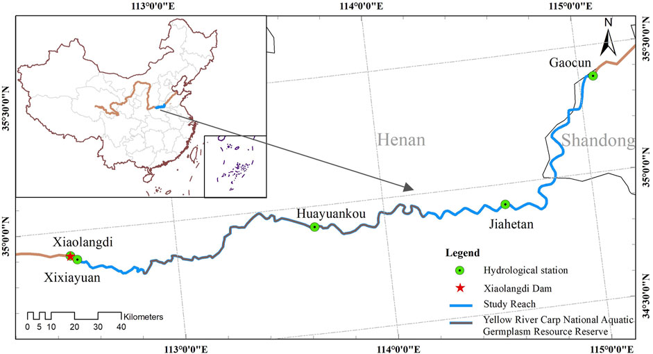
FIGURE 1. Geographical location of the Yellow River in China and the study area comprised the Yellow River downstream of the Xiaolangdi Dam, between Xiaolangdi and Gaocun.
In simulating the physical characteristics of river flows, one-dimensional hydrodynamic modeling can be used to calculate the hydrological and hydrodynamic parameters of different sections at various times and, therefore, provide data to gauge fish habitat suitability. In this study, a one-dimensional hydrodynamic model of the lower Yellow River was constructed based on MIKE11 software, which could simulate the vertical homogeneous water flow of the river according to the terrain and the boundary of the water flow. The Saint-Venant equations and the Abbott–Ionscu 6-point implicit scheme are applied for the numerical simulation. Thus, the governing equations for the one-dimensional hydrodynamic model are as follows:
where x (m) is the distance along the river; t (s) is the time; Z (m) and Q (m3/s) are the water level and water flow of the section, respectively; A (m2) is the cross-sectional area; q (m2/s) is the lateral inflow per unit length; B (m) is the river width; g (m/s2) is gravitational acceleration; and K (m3/s) is the flow modulus.
The data files of the MIKE11 hydrodynamic model mainly include files of sections, river networks, boundaries, and model parameters. The HD (hydrodynamic) module is the basic calculation module of MIKE11, and its module parameters are mainly numerical and physical parameters. Numerical parameters are related to the iterative solution of the equations, such as the number of iterations and iterative calculation accuracy. The physical parameter is mainly the roughness of the river bed. There are 152 measured post-flood sections in the study area. After considering that the two tributaries in the study area have little influence on the model simulation results, no tributaries are added to the one-dimensional hydrodynamic model. The measured flows at the Xiaolangdi Hydrological Station and water levels at the Gaocun Hydrological Station are used as the upper and lower boundary conditions, respectively. The time step of the hydrodynamic model is 1 min. We adjust the roughness of the river bed as model calibrations to improve the simulation accuracy. The outputs of MIKE11 are hydrological elements, such as the water level, flow, and velocity at each moment for 152 sections of the study area.
The habitat suitability index (HSI) is for evaluating the suitability and quality of wildlife habitats, and it is the biological basis of habitat simulations (Boavida et al., 2015; Morales-Marín et al., 2019; Sharma et al., 2022). Habitat suitability curves present the relationship between a species’ growth and its influencing factors (Cho et al., 2012; Knudson et al., 2015), which is generally determined by the appearance frequency and distribution of the species. The HSI varies from 0 to 1 to quantitatively indicate the habitat suitability. In this study, the Yellow River carp is selected as the indicator species for the habitat in the lower reaches of the Yellow River. For the breeding period (including the parent fish spawning period and the larval fish development period), four important habitat factors are selected to determine the habitat suitability of the Yellow River carp. They are water depth h, flow velocity v, water temperature t, and water-level rise dz, and their definitions are as follows.
(1) Flow velocity v: The Yellow River carp is a kind of benthic omnivorous fish and mostly inhabits on the soft riverbed or in water with plentiful aquatic plants. It can lay sticky eggs in various water bodies but prefers slow-flowing or still water with aquatic plants. Its hatching time is 3–7 days in general. Then, its larval fish usually requires a stable water flow for 3–4 days to stay alive. The suitable flow velocity for larval development is in the range of 0–0.15 m/s (Wang et al., 2020).
(2) Water depth h: Neither too shallow nor too deep waters are suitable for fish movements; thus, the water depth of spawning grounds should generally be deeper than 1 m (Jiang et al., 2010b). Larval fish are survivable with a water depth in a free range of .2 m–1.5 m. In addition, a tiny fluctuation of water levels is more conducive to larval fish growth.
(3) Water temperature t: Water temperature is a crucial factor in the process of fish spawning because of its dependence for its occurrence, duration, and its temporal and spatial distribution of the spawning activity (Li et al., 2021). The Yellow River carp can spawn in water with temperatures of 18°C–28°C, and its optimum spawn temperature range is 18°C–24°C. The water temperature of 18°C is a critical value for Yellow River carp hatching. The water temperatures above 18°C could greatly improve the hatching, survival, and emergence rates.
(4) Water-level rise dz: The process of rising water is a necessary condition for stimulating fish to spawn. The rise of water levels is more important for fish dynamics processes no matter what its initial water level is. A certain flow pulse and water-level rise can promote fish spawning, reduce dystocia, and shorten the time of spawning and fertilization. It is also productive for the spawning quantity, spawning rate, and fertilized egg development (Li and Gao, 2013).
To summarize, the four different habitat factors of parent fish and larval fish are obtained, and its suitability curves of each single index are represented by step functions (as shown in Figures 2, 3). Then, the parent fish spawning suitability index (HSIpf) is formulated of water depth h, flow velocity v, and water-level rise dz by Eq. 3, and the larval fish development suitability index (HSIlf) is formulated of the flow velocity v, water depth h, and water temperature t by Eq. 4. In this paper, we propose the Habitat Suitability Index HSI of the Yellow River carp by the mean values of HSIpf and HSIlf in Eq. 5 as follows.
where
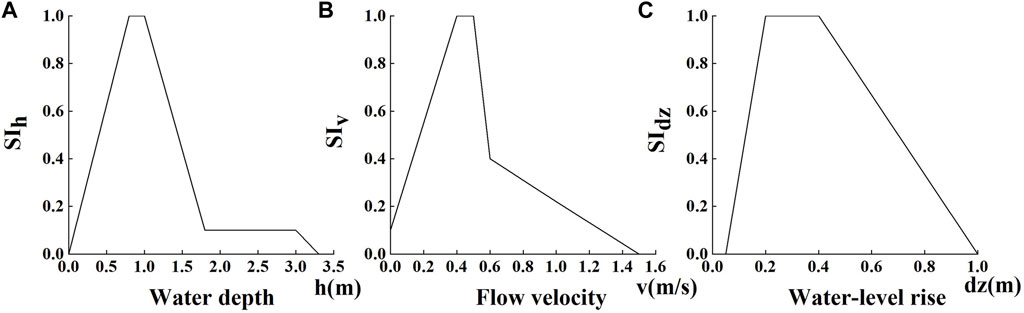
FIGURE 2. Parent fish spawning suitability index of the Yellow River carp in the study area. (A) Water depth h; (B) flow velocity v; (C) water-level rise dz.
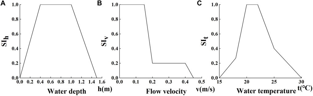
FIGURE 3. Larval fish development suitability index of the Yellow River carp in the study area. (A) Water depth h; (B) flow velocity v; (C) water temperature t.
We have the water temperature t, and we calculate the water depth h and flow velocity v of the river cross section using the one-dimensional hydrodynamic model. Then, the values of
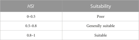
TABLE 1. Suitability for the Yellow River carp under different values of the habitat suitability index (HSI).
In this study, the habitat suitability index is used to build the habitat suitability model of the Yellow River carp. Furthermore, it is combined with the one-dimensional hydrodynamic modeling for habitat factors to define the habitat suitability and assess the suitability of the habitat.
The Nash–Sutcliffe efficiency (NSE) and the root mean square error (RMSE) are selected to evaluate the accuracy of the hydrodynamic model. The NSE is a statistical parameter that describes the fitting degree between simulation and measurement. The more it closes to 1, the better the simulation of the hydrodynamic model is. The RMSE represents the deviation between the simulated and the measured value. The more it closes to 0, the smaller the model error is.
The flood from August 16 to September 11 in the year 2018 was chosen to calibrate the riverbed roughness in the study area, and another flood from September 15 to October 10, 2018, was chosen to verify the hydrodynamic model. If the model can well simulate the flood process, it shows that the model has good applicability at all water levels and can also well reflect the hydrodynamic characteristics during the spawning period.
Three hydrological stations (Xixiayuan, Huayuankou, and Jiahetan) were selected to calibrate and verify this model. The range of riverbed roughness in this study was determined as .020 to .032. The water-level calibration and verification results of the three hydrological stations are shown in Figure 4, which well-fitted the water flow under different incoming waters and captured the process of water-level fluctuation, such as the rise and fall in 8.28–9.4. We listed the NSE and RMSE in Table 2 for the results of Figure 4. The minimum NSE for calibration and verification was .769, and the maximum RMSE was .161 m. This means that the model can accurately reflect the process of hydrodynamic changes and can be used for the construction of habitat models.
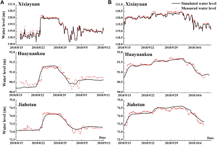
FIGURE 4. Calibration and verification results of the measured and simulated water levels of the three hydrological stations (Xixiayuan, Huayuankou, and Jiahetan) in the study area during 2018.8.16–2018.9.11 and 2018.9.15–2018.10.10 periods. (A) Water-level calibration results; (B) water-level verification results.
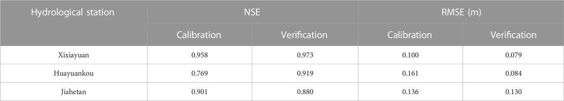
TABLE 2. Criteria of fit for the simulation of the hydrological stations of the Yellow River. NSE = Nash–Sutcliffe efficiency; RMSE = root mean square error.
April to June is the spawning period of the Yellow River carp every year. It is the most critical and vulnerable stage for the Yellow River carp to spawn and develop. To breed successfully, the Yellow River carp has extremely high requirements on the ecological and hydraulic conditions of the habitat during its spawning period. There are 16 spawning grounds marked by stars (Figure 5), which are measured spawning locations in the Henan section of the Yellow River studied by Hui et al. (2019). To verify the simulation of the habitat model, the habitat factors from April 1 to June 30 of the year 2014 were chosen. The daily HSI values of 152 sections were calculated by these habitat factors, according to Eqs 3, 4, 5, and then, the daily average HSI values of each section from April to June were obtained. There were 19 suitable spawning reaches shown in red lines (Figure 5). Their size Lsr and spawning habitat quality HSIsr are displayed in Supplementary Table S1. Most of the 16 measured spawning grounds studied by Hui et al. (2019) (black stars) fell within the spawning reaches (red lines) simulated by the habitat suitability model (Figure 5). This indicates that the habitat suitability model of the Yellow River carp can simulate accurately the positions of spawning habitats. For a measured spawning ground, its HSI value is the HSI value of the nearest section among 152 sections. 87.5% of the 16 measured spawning grounds had their HSI values greater than .5 except grounds 7 and 10 (Table 3). The spawning area is simulated by the average value of HSI from April to June; the measured spawning grounds only need to meet their reproductive requirements for a long enough time in April–June rather than the whole 3 months, so the model simulation results have a certain deviation from the measured spawning ground. These spawning grounds are generally suitable for the Yellow River carp, which is consistent with Hui’s findings (Table 1). This indicates that the habitat suitability model of the Yellow River carp has a good simulation effect and can well represent the quality of spawning habitats.
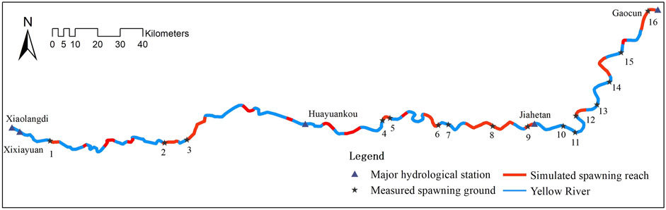
FIGURE 5. Predicted spawning ground map by the habitat suitability model of the Yellow River carp in the reach from Xiaolangdi to Gaocun of the Yellow River from April 1 to June 30, 2014.
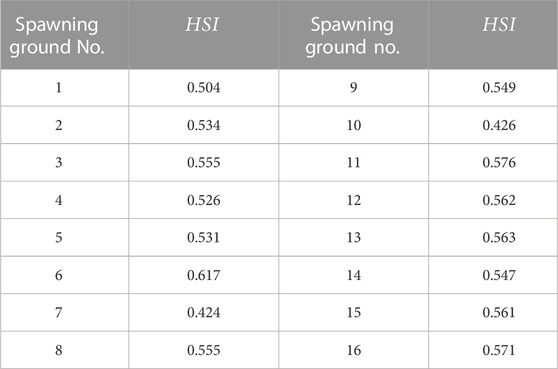
TABLE 3. HSI values of the spawning grounds of the Yellow River carp from April 1 to 30 June 2014.
The Xiaolangdi Dam was built in 2001. Hence, April–June every year in the 1980–1990 period was selected as the representative period before the dam construction, and April–June in the 2006–2018 period was selected as the representative period after dam construction. In this study, we defined the HSI, HSIpf, and HSIlf values of the whole study area, i.e., the Xiaolangdi–Gaocun section of the lower Yellow River by the average value of 152 cross sections located in it. The HSI, HSIpf, and HSIlf daily values from April 1 to June 30 in these two representative periods were simulated by the habitat suitability model and are presented in Figure 6. Furthermore, it was quantitatively described by the variations, as shown in Table 4.
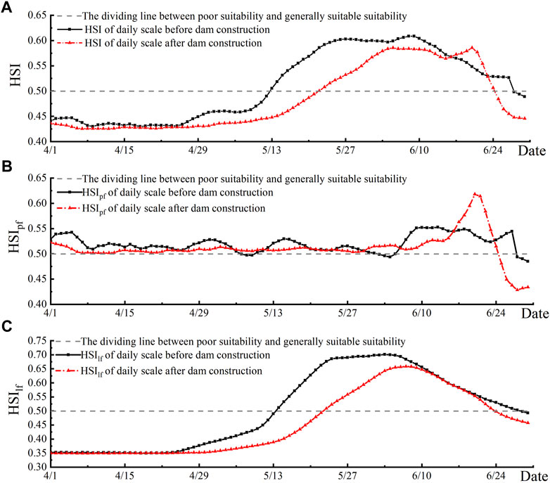
FIGURE 6. Simulation of the habitat suitability index (HSI), parent fish spawning suitability index (HSIpf), and larval fish development suitability index (HSIlf) of the Yellow River carp at a daily scale during April 1–June 30 from 1980–1990 (before dam construction) to 2006–2018 (after dam construction). (A) Comparison of the daily-scale habitat suitability index (HSI); (B) comparison of the daily-scale parent fish spawning suitability index (HSIpf); (C) comparison of the daily-scale larval fish development suitability index (HSIlf).

TABLE 4. Percentage variation of each suitability index (SI) for the Yellow River carp of the whole study area before and after the dam construction.
From Table 4, the following could be observed: 1) the discharge of the Xiaolangdi Dam from April to June is regulated. However, the water-level rise index
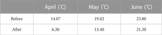
TABLE 5. Multi-year monthly average water temperature of the Xiaolangdi Hydrological Station from April to June before and after dam construction.
The period from mid-June to early-July after dam construction is the pre-flood water and the sediment regulation period of the Xiaolangdi Reservoir. The Xiaolangdi Reservoir releases its clear water during this period, and its reservoir water level drops sharply accordingly (Wang et al., 2019). Thus, released water creates a rapid increase in the water level of the downstream river, as shown in the red line in Figure 7A from June 15 to June 22. The continuous rising time of the water level from June 15 to June 22 (Figure 7A) coincides with the timing of the Yellow River carp spawning and hatching cycle, which is bound to have an impact on the reproduction of the Yellow River carp. The continuously rising water level creates the increasing water-level rise index (
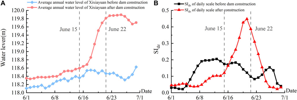
FIGURE 7. Simulated average water level of the Xixiayuan Hydrological Station over the years and the daily-scale water-level rise index
The continuous increase of the water level from June 15 to June 22 is beneficial to the breeding of the Yellow River carp. However, on the whole, the operation of the Xiaolangdi Dam makes the flow downstream of the dam smoother from April to June (excluding pre-flood water and the sediment regulation period), resulting in a 35.75% decrease in the water-level rise index
After the completion of the dam, the low-temperature water discharge from the Xiaolangdi Reservoir in April and May had a greater impact on the water temperature downstream of the dam but had a less impact in June (Table 5). There is a huge gap between the water temperature suitability index
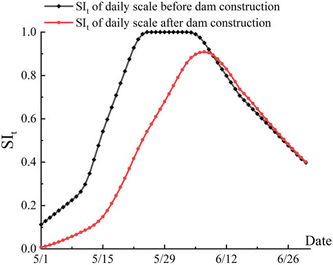
FIGURE 8. Comparison of the daily-scale water temperature index (SIt) of the Yellow River carp before and after dam construction.
The period of April, May, and June in the years 1980–1990 was chosen as the representative period before the dam construction, and April, May, and June in the years 2006–2018 was chosen as the representative period after dam construction. The daily average HSI values of each section for many years were calculated in representative periods by the habitat suitability model, and the habitat suitability index HSIsr and spawning reach size Lsr of the Yellow River carp spawning reach were obtained (Table 6). The corresponding spawning reaches are depicted in Figure 9.
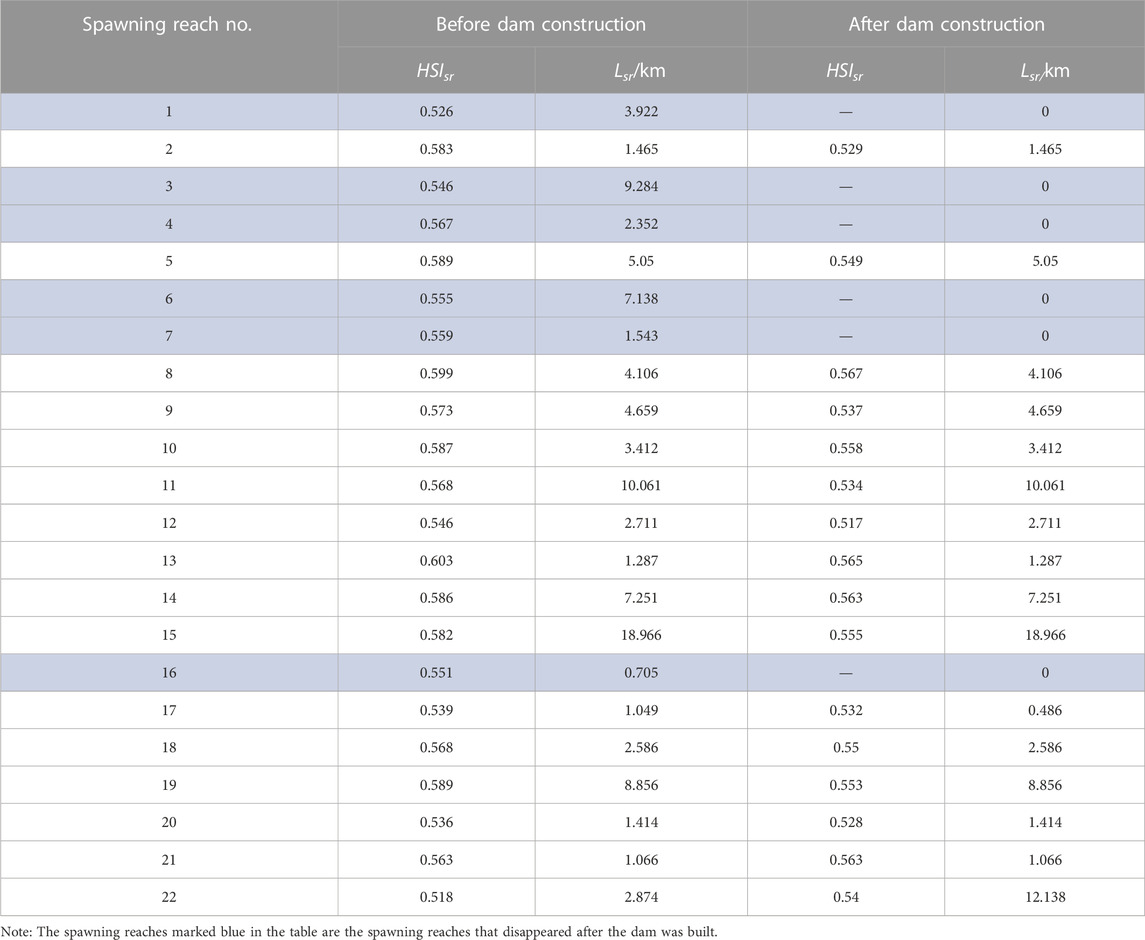
TABLE 6. Habitat suitability index of the spawning reach HSIsr and the size of spawning reaches Lsr for the Yellow River carp, before and after the construction of the Xiaolangdi Dam.
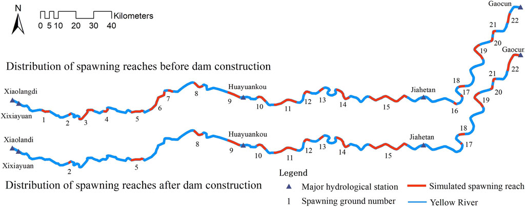
FIGURE 9. Simulated distribution of the Yellow River carp spawning reaches from April 1 to June 30 in 1980–1990 (before dam construction) and 2006–2018 (after dam construction).
From Table 6 and Figure 9, it is clear that the establishment of the Xiaolangdi Dam has changed the size and locations of the spawning reaches of the Yellow River carp. There were 22 spawning reaches simulated in the study area before dam construction in 1980–1990, with a total length of 101.757 km and an average habitat suitability index (HSIsr) value (the average of all spawning reach HSIsr values) of .565 (Table 6). However, after the dam construction, the number of spawning reaches was predicted as 16, with their size reduced to 85.241 km, and the average habitat suitability index (HSIsr) value was .546 during the years 2006–2018. The average habitat suitability index (HSIsr) decreased slightly from .565 before dam construction to .546 after dam construction, but the extent of the spawning reaches decreased sharply by 16.23%, and some spawning reaches even disappeared. We can also see the differences in size and locations of the Yellow River carp spawning reaches (Figure 9). Thus, we demonstrate that the establishment of the Xiaolangdi Dam has changed the locations of the spawning reaches of the Yellow River carp and likely reduced their size.
It can be seen that before and after dam construction, the spawning reaches located in the Xiaolangdi–Huayuankou section, which is directly downstream of the dam, have undergone great changes (Figure 9). There are five spawning reaches that have completely disappeared, which are reach No. 1, No. 3, No. 4, No. 6, and No. 7 marked in blue in Table 6. This is the direct result of the Xiaolangdi Dam construction. These five disappearing reaches are the principal domains affected by the low-temperature water released from the Xiaolangdi Reservoir. After all, they are presumably no longer suitable for the carp due to the low-temperature habitat condition. In addition, the further downstream section from Huayuankou to Gaocun is significantly less affected by the dam. Its distribution of spawning reaches has only one spawning reach, i.e., reach No. 16, that disappeared completely, and its average habitat suitability index (HSIsr) drops slightly from .564 to .547.
Based on the one-dimensional hydrodynamic model and the habitat suitability model of the Yellow River carp, the simulation of the habitat suitability before the dam construction (1980–1990) and after the dam construction (2006–2018) shows that the habitat suitability index reduces generally (Figure 6A), and the scale of the Yellow River carp spawning reaches in the lower reaches of the Yellow River decreases after the dam construction (Table 6; Figure 9).
Water-level rises increase the chance of shoal flooding and the extent of still-water areas. It is not only conducive to the spawning of the Yellow River carp but also to the transfer of food organisms between nearshore areas and the main river trough, thereby expanding the habitat for fish. After the dam construction, the operation of the Xiaolangdi Reservoir makes the flow downstream of the dam smoother from April to June (excluding pre-flood water and the sediment regulation period). This reduces the water-lever rise suitability index
The water temperatures above 18°C are critical for the Yellow River carp to spawn and hatch. The appropriate temperature can greatly improve its hatching, survival, and emergence rates. Otherwise, it will be another unfavorable factor for reproduction. After the dam construction, the large heat capacity of the impoundment in the Xiaolangdi Reservoir causes a significant difference in temperature between the discharged water and the natural river water. The low-temperature discharged water released from the Xiaolangdi Reservoir can influence hundreds of kilometers downstream. It delays and flattens the water temperature downstream. The Xiaolangdi–Huayuankou reach is the main affected section of the released low-temperature water, and the impact period is mainly from November to June (Jiao and Lei, 2021), coinciding with the usual breeding period of the Yellow River carp. This released low-temperature water results in a decline and lag in the water temperature suitability index
The impact of the construction and operation of the Xiaolangdi Dam on the river ecology is two-fold. The Xiaolangdi Reservoir has changed the hydrological regime of the river downstream. The notably changed flow velocity, water levels, water-level rises, and water temperatures result in a decline in the quality of the Yellow River carp reproduction and a reduction in the size of the spawning reaches. The release of the lower-temperature bottom water from the reservoir has a direct impact on the development and reproduction of fish downstream of the dam. Furthermore, the dam has blocked channels used by migratory species for feeding and reproduction, with sharp declines for these fishes. For instance, some fishes in the Yellow River, like the migratory Coreius septentrionalis (Nichols) and Coilia nasus, are now endangered (Han et al., 2013).
However, the completion and operation of the Xiaolangdi Dam also plays a role in improving the ecological environment to some extent. It now ensures a continuous river flow downstream and increases the guarantee rate of ecological flow (Gao et al., 2014). Meanwhile, the sediment from the reservoir constantly scours the riverbed downstream, the floodplain flux is increased, and the river morphology tends to be stable. All of these changes provide a more stable habitat for organisms. There are complex interactions among these factors which affect the fish growth, and the responses of fish are also unclear, which makes it more difficult to establish clear correlations between fish habitat factors and habitat suitability. Deep research on the impact of multiple factors on fish habitats is still merited.
This study implemented a one-dimensional hydrodynamic model and built a habitat suitability model for the Yellow River carp to depict dynamic changes of reproduction suitability in the lower reaches of the Yellow River before and after the construction of the Xiaolangdi Dam. By simulating and analyzing the habitat suitability and spawning reaches of the Yellow River before and after the dam construction, we get the main conclusions as follows:
(1) After the dam construction, the artificially controlled discharges of the Xiaolangdi Reservoir mainly result in the water-level rise and the water temperature drop. This operation reduces the habitat suitability HSI of the Yellow River carp by 5.28% in average, including 1.89% for the parent fish spawning suitability index HSIpf and 8.95% for the larval fish developmental suitability index HSIlf. It suggests that the larval fish development is more affected by the dam.
(2) Dam construction reduces the habitat quality of spawning reaches and may even lead to the disappearance of spawning reaches. Compared with the periods of 1980–1990 before dam construction and 2006–2018 after construction, the number of spawning reaches downstream of the dam reduces from 22 to 16, their extent reduces by 16.23%, and their habitat suitability decreases from .564 to .547. In particular, the effect of dam construction on the Yellow River carp reproduction is more pronounced in the downstream section close to the dam from Xiaolangdi to Huanakou, where five spawning reaches disappear. However, in the reach between Huayuankou and Gaocun farther away downstream from the dam, the effect works weaker.
This paper has studied the response of the Yellow River carp to hydrological rhythm changes after dam construction. It also provides a reference for restoring the spawning habitat of the Yellow River carp and constructing the Xiaolangdi Reservoir’s ecological dispatch, which considers the reproductive needs of the Yellow River carp. Furthermore, the response and feedback relationship between the hydrological situation, habitat demand, and fish behavior under dam construction and operation will be further clarified. In the future, the reservoir regulation mechanism that is conducive to fish survival and river ecological health could be explored to serve the optimization of the Xiaolangdi Reservoir and other large reservoirs.
The datasets presented in this article are not readily available because the data are obtained from the project and used under the permission of the current research. Requests to access the datasets should be directed to Qiongyao Ruan, MTIwMjAyMjM4MDIxQG5jZXB1LmVkdS5jbg==.
QR: data curation, formal analysis, methodology, software, and writing—original draft. WL: methodology, software, reviewing, and editing. SZ: resources, conceptualization, writing—reviewing and editing, supervision, funding acquisition, and project administration. CT: methodology and validation. JH: data curation and formal analysis.
This study was supported by the National Natural Science Foundation of China (52061135104) and the Joint Funds of the National Natural Science Foundation of China (U2243236).
The authors thank Cynthia Kulongowski from Liwen Bianji (Edanz) (www.liwenbianji.cn/) for editing the English text of a draft of this manuscript.
The authors declare that the research was conducted in the absence of any commercial or financial relationships that could be construed as a potential conflict of interest.
All claims expressed in this article are solely those of the authors and do not necessarily represent those of their affiliated organizations, or those of the publisher, the editors, and the reviewers. Any product that may be evaluated in this article, or claim that may be made by its manufacturer, is not guaranteed or endorsed by the publisher.
Ahmadi-Nedushan, B., St-Hilaire, A., Bérubé, M., Robichaud, E., Thiemonge, N., and Bobee, B. (2010). A review of statistical methods for the evaluation of aquatic habitat suitability for instream flow assessment. River Res. Appl. 22 (5), 503–523. doi:10.1002/rra.918
Boavida, I., Santos, J. M., Ferreira, T., and Pinheiro, A. (2015). Barbel habitat alterations due to hydropeaking. J. hydro-environment Res. 9 (2), 237–247. doi:10.1016/j.jher.2014.07.009
Chang, Y. L., Hsieh, T. Y., Chen, C. H., and Yang, J. C. (2013). Two-dimensional numerical investigation for short-and long-term effects of spur dikes on weighted usable area of Rhinogobius candidianus (Goby). J. Hydraulic Eng. 139 (12), 1297–1303. doi:10.1061/(asce)hy.1943-7900.0000789
Cho, Y., Lee, W. C., Hong, S., Kim, H. C., and Kim, J. B. (2012). GIS-based suitable site selection using habitat suitability index for oyster farms in Geoje-Hansan Bay, Korea. Ocean Coast. Manag. 56, 10–16. doi:10.1016/j.ocecoaman.2011.10.009
Collier, M., Webb, R. H., and Schmidt, J. C. (1996). Dams and rivers: A primer on the downstream effects of dams. US department of the interior, US geological survey. Pennsylvania: DIANE.
Fantin-Cruz, I., Pedrollo, O., Girard, P., Zeilhofer, P., and Hamilton, S. K. (2015). Effects of a diversion hydropower facility on the hydrological regime of the Correntes River, a tributary to the Pantanal floodplain, Brazil. J. Hydrology 531, 810–820. doi:10.1016/j.jhydrol.2015.10.045
Gao, G., Li, X., and Ma, Y. (2014). Research on ecological scheduling of Xiaolangdi reservoir. Yellow River 36 (9), 76–79. doi:10.3969/j.issn.1000-1379.2014.09.025
Han, T., Xiong, Y., and Sun, X. (2013). The impact of the Yellow River Xiaolangdi Project on aquatic biological resources and the reflection on the conservation of resources. China Fish. (6), 28–29. doi:10.3969/j.issn.1002-6681.2013.06.013
Hui, J., Jie, Z., and He, H. (2019). Spawning ground status of fish that release benthic eggs in the henan section of Yellow River. J. Hydroecology 40 (4), 108–114. doi:10.15928/j.1674-3075.2019.04.014
Im, D., Choi, S. U., and Choi, B. (2018). Physical habitat simulation for a fish community using the ANFIS method. Ecol. Inf. 43, 73–83. doi:10.1016/j.ecoinf.2017.09.001
Jiang, N., Jiang, B., and Lei, G. (2019). Influence of waterway regulation project on habitat suitability index of Four Major Chinese Carps in Dongliu channel in lower Yangtze River. Yangtze River 50 (5), 5–9. doi:10.16232/j.cnki.1001-4179.2019.05.002
Jiang, X., Arthington, A., and Changming, L. (2010b). Environmental flow requirements of fish in the lower reach of the Yellow River. Water Int. 35 (4), 381–396. doi:10.1080/02508060.2010.506261
Jiang, X., Zhao, W., and Zhang, W. (2010a). The impact of Xiaolangdi Dam operation on the habitat of Yellow River Carp (Cyprinus(Cyprinus) carpio haematopterus Temminck et Schlegel). Acta Ecol. Sin. 30 (18), 4940–4947.
Jiao, R., and Lei, G. (2021). “Research on water temperature monitoring and evaluation along the lower reaches of the Yellow River. Hohai university, xi'an university of Technology, China dredging association, shanxi water conservancy society,” in Proceedings of the 9th China Water Ecology Conference in 2021, 241–249.
Karr, J. R. (1981). Assessment of biotic integrity using fish communities. Fisheries 6 (6), 21–27. doi:10.1577/1548-8446(1981)006<0021:aobiuf>2.0.co;2
Knudson, M. D., VanLooy, J. A., and Hill, M. J. (2015). A habitat suitability index (HSI) for the Western prairie fringed orchid (Platanthera praeclara) on the Sheyenne National Grassland, North Dakota, USA. Ecol. Indic. 57, 536–545. doi:10.1016/j.ecolind.2015.05.011
Li, B., and Gao, J. (2013). Factors affecting the gonadal development of Yellow River Carp broodstock. Fish. Guide be Rich (17), 30–31.
Li, T., Mo, K., Wang, J., Chen, Q., Zhang, J., Zeng, C., et al. (2021). Mismatch between critical and accumulated temperature following river damming impacts fish spawning. Sci. Total Environ. 756, 144052. doi:10.1016/j.scitotenv.2020.144052
Liu, J., Zang, C., Tian, S., Yang, H., Jia, S., You, L., et al. (2013). Water conservancy projects in China: Achievements, challenges and way forward. Glob. Environ. Change 23 (3), 633–643. doi:10.1016/j.gloenvcha.2013.02.002
Morales-Marín, L., Rokaya, P., Sanyal, P., Sereda, J., and Lindenschmidt, K. (2019). Changes in streamflow and water temperature affect fish habitat in the Athabasca River basin in the context of climate change. Ecol. Model. 407, 108718. doi:10.1016/j.ecolmodel.2019.108718
Morita, K., and Yamamoto, S. (2002). Effects of habitat fragmentation by damming on the persistence of stream-dwelling charr populations. Conserv. Biol. 16 (5), 1318–1323. doi:10.1046/j.1523-1739.2002.01476.x
Mouton, A. M., Schneider, M., Depestele, J., Goethals, P. L., and De Pauw, N. (2007). Fish habitat modelling as a tool for river management. Ecol. Eng. 29 (3), 305–315. doi:10.1016/j.ecoleng.2006.11.002
Muñoz-Mas, R., Martínez-Capel, F., Schneider, M., and Mouton, A. M. (2012). Assessment of Brown trout habitat suitability in the jucar River Basin (Spain): Comparison of data-driven approaches with fuzzy-logic models and univariate suitability curves. Sci. Total Environ. 440, 123–131. doi:10.1016/j.scitotenv.2012.07.074
Sharma, A., Baruah, A., Mangukiya, N., Hinge, G., and Bharali, B. (2022). Evaluation of Gangetic dolphin habitat suitability under hydroclimatic changes using a coupled hydrological-hydrodynamic approach. Ecol. Inf. 69, 101639. doi:10.1016/j.ecoinf.2022.101639
Sun, G., and Sheng, L. (2000). Theory of keystone species in ecosystems: New idea, new mechanism, new approach. J. Northeast Normal Univ. Nat. Sci. Ed. 32 (3), 73–77. doi:10.16163/j.cnki.22-1123/n.2000.03.017
Tang, C., Yan, Q., Li, W., Yang, X., and Zhang, S. (2022). Impact of dam construction on the spawning grounds of the four major Chinese carps in the Three Gorges Reservoir. J. Hydrology 609, 127694. doi:10.1016/j.jhydrol.2022.127694
Wang, R., Huang, J., and Ge, L. (2020). Study of ecological flow based on the relationship between cyprinusy carpio habitat hydrological and ecological response in the lower Yellow River. J. Hydraulic Eng. 51, 1175–1187. doi:10.13243/j.cnki.slxb.20200184
Wang, T., Li, X., and Qu, S. (2019). “Water and sediment regulation of Xiaolangdi reservoir in medium and small floods during recent pre-flood season,” in Yellow River (New Haven: Yale University Press), 47–50.
Wang, Y., Rhoads, B. L., and Wang, D. (2016). Assessment of the flow regime alterations in the middle reach of the Yangtze river associated with dam construction: Potential ecological implications. Hydrol. Process. 30 (21), 3949–3966. doi:10.1002/hyp.10921
Yi, Y., Tang, C., Yang, Z., and Chen, X. (2014). Influence of manwan reservoir on fish habitat in the middle reach of the lancang river. Ecol. Eng. 69, 106–117. doi:10.1016/j.ecoleng.2014.03.026
Yi, Y., and Yue, S. (2011). Habitat suitability function of four major Chinese Carps spawning sites in the Yangtze River. J. Basic Sci. Eng. 19, 117–122. doi:10.3969/j.issn.1005-0930.2011.s1.013
Zhang, C., and Han, X. (2016). The current situation and protection strategies of carp germplasm resources in the Yellow River in Zhengzhou. Henan Fish. (1), 4–6.
Keywords: fish habitat, habitat suitability model, hydrodynamic model, spawning reach, Xiaolangdi Dam
Citation: Ruan Q, Li W, Zhang S, Tang C and Hou J (2023) Effects of dam construction on the reproduction of the Yellow River carp (Cyprinus carpio) in lower reaches of the Yellow River, China. Front. Environ. Sci. 10:1114448. doi: 10.3389/fenvs.2022.1114448
Received: 02 December 2022; Accepted: 30 December 2022;
Published: 13 January 2023.
Edited by:
Xiaoning Zhao, Nanjing University of Information Science and Technology, ChinaReviewed by:
Li Jian, China University of Geosciences Wuhan, ChinaCopyright © 2023 Ruan, Li, Zhang, Tang and Hou. This is an open-access article distributed under the terms of the Creative Commons Attribution License (CC BY). The use, distribution or reproduction in other forums is permitted, provided the original author(s) and the copyright owner(s) are credited and that the original publication in this journal is cited, in accordance with accepted academic practice. No use, distribution or reproduction is permitted which does not comply with these terms.
*Correspondence: Shanghong Zhang, emhhbmdzaDkyOEAxMjYuY29t
Disclaimer: All claims expressed in this article are solely those of the authors and do not necessarily represent those of their affiliated organizations, or those of the publisher, the editors and the reviewers. Any product that may be evaluated in this article or claim that may be made by its manufacturer is not guaranteed or endorsed by the publisher.
Research integrity at Frontiers
Learn more about the work of our research integrity team to safeguard the quality of each article we publish.