 Qianqian Gou1
 Guohua Wang
- 1College of Geographical Sciences, Shanxi Normal University, Taiyuan, China
- 2Key Laboratory of Desert and Desertification, Northwest Institute of Eco-Environment and Resources, Chinese Academy of Science, Lanzhou, China
- 3Laboratory of Watershed Hydrology and Ecology, Linze Inland River Basin Comprehensive Research Station, Chinese Ecosystem Research Network, Northwest Institute of Ecology and Environmental Resources, Chinese Academy of Sciences, Lanzhou, China
The water diversion scheme of Heihe River Basin was implemented in 2000. Herein, we investigated the dynamic changes in soil moisture content and analyzed the fundamental reasons supporting the water diversion plan in this typical inland river basin in northwest China. Accordingly, we selected three typical landscape gradients—a mountain water conservation forest belt, an artificial sand-fixing forest belt at the edge of a desert oasis, and a desert riparian forest belt in the upper, middle, and lower reaches of the Heihe River Basin, respectively. In these diverse landscapes, an environmental measuring system was used to continuously monitor the dynamic and differentiation regularity of soil moisture in the 0–160 cm layer for 5 years. The results revealed that 1) the soil moisture content in each landscape increased and varied significantly across seasons. In the upper and middle reaches, the soil moisture content was significantly higher during the growing season than in the non-growing season, whereas the lower reach displayed a converse pattern. 2) The distribution of soil moisture at various depths of soil profiles varied significantly for each landscape. As the soil depth increased, the soil moisture in the upper reach decreased. Although the deep layers (120–160 cm) could store water in the non-growing season, the stored water was consumed during the growing season. The soil moisture content in the mid-reach initially increased, later decreased, and ultimately attained its highest level at 40–60 cm; however, the soil moisture content in the lower reach increased, and reached its highest level at 120–160 cm. 3) In the upper and middle reaches, the coefficient of variation of soil moisture decreased with an increasing soil depth, whereas the lower reach exhibited a converse trend. Similarly, the coefficient of variation of soil water storage were higher during the non-growing season than during the growing season within the upper and middle reaches, whereas an opposite trend was observed in the lower reach. 4) Since the implementation of the Heihe river water diversion plan, the soil moisture content in both the upper and middle reaches have increased but that of the lower reach has fluctuated and declined, especially in the shallow depths during the growing season. The present findings imply that the lower reaches of the Heihe River may require additional water transfers during the growing season.
Introduction
The inland river basin is a key component of the ecological barrier in arid areas and an important zone for the construction of ecological civilization. Generally, an inland river basin in an arid region is composed of upstream mountain regions, mid-stream oasis, and downstream desert regions (Wang et al., 2017). Owing to the limited water and soil resources, human and agricultural activities along with the consequent utilization of water resources primarily occur in the oasis, which creates an extremely fragile ecology and environment in the mid- and downstream regions. The continuous expansion of the oasis is increasing the water consumption and resulting in increasingly serious problems of water shortage and degradation of natural vegetation in the region. In particular, soil moisture is an essential limiting factor for plant growth, development, and survival in inland river drainage basins of arid regions (Hu et al., 2009; Wang et al., 2017; Liu et al., 2021). However, soil moisture content exhibits significant temporal variability and spatial heterogeneity (Cheng et al., 2014; Jia & Shao, 2014; Suo et al., 2017) across various landscapes (Liu et al., 2002; Chang & Chang, 2021). Therefore, monitoring the dynamic characteristics of soil moisture in typical landscape zones in the upper, middle, and lower reaches after water diversion is crucial for ensuring the ecological security of ecosystems prevailing in inland river basins.
Prior studies on the spatial and temporal variability of soil moisture in inland river basins have primarily focused on the monitoring and analysis of a single landscape. For instance, the soil moisture content and its coefficient of variation in the Qinghai spruce forest (Picea crassifolia) located in the upper Qilian Mountains of the Heihe River decline with an increasing soil depth, and the spatial variation increases with elevation (Lu et al., 2020). More specifically, the spatial and temporal variations in soil moisture are negatively correlated with the river distance and positively correlated with the soil depth in the lower Tarim River (Ma et al., 2010). These studies demonstrated that soil moisture in diverse landscapes tends to exhibit significant temporal variability and spatial heterogeneity (Cheng et al., 2014; Jia & Shao, 2014; Suo et al., 2017), and the distribution characteristics under various landscapes differ significantly (Liu et al., 2002; Chang & Chang, 2021). In addition, the movement processes of soil water vary significantly across the diverse landscapes of the inland river basins, and the factors responsible for these deviations are closely related to the type of soil, vegetation, and ground cover. However, relatively few studies have systematically evaluated the spatial and temporal distribution patterns of soil water across diverse landscapes.
The Heihe River Basin, located between 98° and 101°30′E and 38°–42°N, is a typical inland river basin in northwest China, wherein the limitations of water resources and related environmental problems are becoming increasingly prominent because of low precipitation, strong evaporation, and agricultural activities of an increased human population. Consequently, the downstream region of this inland river basin has experienced severe ecological degradation such as the disappearance of a terminal lake. Thus, a water diversion scheme was implemented in 2000 to curb the ecological degradation in the downstream region of Heihe River. The implementation of the water diversion scheme aimed to rationalize the allocation of domestic water, production, and ecological water and, especially, recover the condition of ecological environment in the downstream region. The Heihe River Basin portrays an evident multilevel vertical, natural landscape with diverse natural geographic units (Lu et al., 2020). Thus, the variations in the soil water occurring after the implementation of the water diversion scheme in the various landscapes along the river corridor must be assessed to preserve the environmental ecology therein. Although certain studies have investigated the dynamic variations in soil moisture occurring in the Heihe river basin after the water diversion scheme, only a handful of studies have comprehensively evaluated the soil moisture in various landscapes across different regions of the basin. For instance, Jiang et al. studied the soil moisture characteristics of the grassland situated in the Qilian Mountain region in the upper reaches and determined that soil moisture increased first, then decreased with increasing soil depth; Liu et al. investigated the soil moisture of artificial forest (Haloxylon ammodendron) in the mid-basin region and determined that the soil moisture content at the greater depths were much higher than that at the shallower depths. However, these previous studies have primarily focused on the dynamic processes involving soil moisture in a single landscape unit, e.g., deserts (Curreli A et al., 2013), farmlands (Zhao & Zhao., 2014), and woodlands (Wang et al., 2013). Thus, the comprehensive analyses of soil moisture dynamics across multiple landscapes are imminently required. In particular, long-term monitoring and comparative analysis of soil moisture dynamics in typical landscape zones within the Heihe river basin (Hu et al., 2015) will provide valuable insights to the relevant managers, ecological planners, and policy makers.
In this study, three typical landscapes along the river corridor of the Heihe river basin were selected as representative cases, including three typical vertical landscape zones, namely, the mountainous water-conserving forest zone, desert oasis edge of the artificial sand-fixing forest zone, and desert riparian forest zone. This study aims to reveal the temporal (annual and seasonal) and spatial (varying soil depths) variation characteristics as well as the differentiation patterns of soil moisture across the diverse vertical landscape zones in the inland river basin. Accordingly, the differences in soil moisture variation across various landscape zones were analyzed to provide a basis for efficient management of water resources, vegetation construction, soil and water conservation, agricultural construction, ecological restoration, and developing protections in inland river basins, thereby ensuring the sustainable ecological development of the basin.
Study sites and method
Study sites
The Heihe river basin is located in the central region of the Qilian Mountains and the Hexi Corridor (37°45′–42°40′N, 96°42′–102°04′E), with a basin area of approximately 130,000 km2 and a flow length of 821 km that is segmented into upper, middle, and lower reaches. The upper reach of the basin cover the region above the Yingluo Gorge at the mouth of the Qilian Mountains, the middle reach is situated between Yingluo Gorge and Zhengyi Gorge, and the lower reach is located below Zhengzhi Gorge (Zhao et al., 2009). Overall, the upper, middle, and lower reaches of the basin contain glacial snow tundra, a mountain vegetation zone, pre-mountain desert, an oasis-irrigated agricultural system, oasis-edge sand-fixation zone, desert vegetation, and a riparian forest vegetation landscape zone (Song et al., 2003).
This study selected three typical landscape zones: the upstream water-conserving forest, midstream desert-oasis edge sand-fixing forest, and downstream desert riparian forest zone (Figure 1). The upstream mountainous vegetation zone spans across the West Water Containment Forest in the Qilian Mountains (38°34.1′N, 100°17′E, elevation: 2,731 m), with an alpine semi-arid and semi-humid mountainous forest-steppe climate, annual mean temperature of 0.8°C, annual mean precipitation of 370.5 mm, annual mean evaporation of 1,051.7 mm, mean relative humidity of 60.0%, and forest cover of 40.1%. Thereafter, the midstream desert-oasis transition zone is located at the edge of the desert oasis in Linze County, Gansu (39°20.9′N, 100°07.8′E, elevation: 1,382 m), with a continental desert-steppe climate, precipitation concentrated from June to September, an annual average temperature of 7.6°C, an annual average precipitation of 117.1 mm, and an annual average evaporation of nearly 2000 mm. Lastly, the downstream desert riparian forest zone covers the central region of Ejina (42°01′N, 101°14′E, elevation: 920.46 m) with a typical desert climate, wherein the average annual temperature is 8.2°C, average annual rainfall is 37.9 mm, and the evaporation is more than 3,700 mm. Owing to the presence of river water supply, the riparian forest zone is distributed in the lowlands of the river valley and lake basin, with a depression degree of 0.8. The three observation sites experience an almost consistent seasonal pattern, undergoing a growing season from May to October and a non-growing season from November to April (refer to Table 1 for specific characteristics of precipitation, vegetation, and soil at the observation sites).
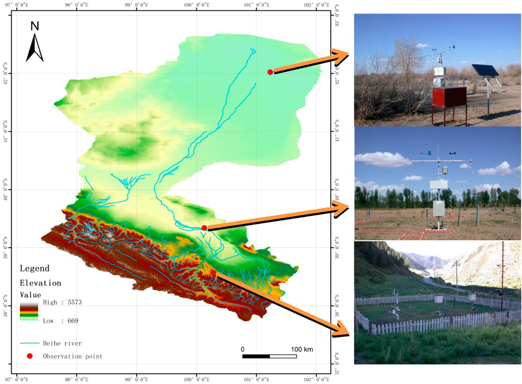
FIGURE 1. Distribution map of observation points in Heihe river basin.
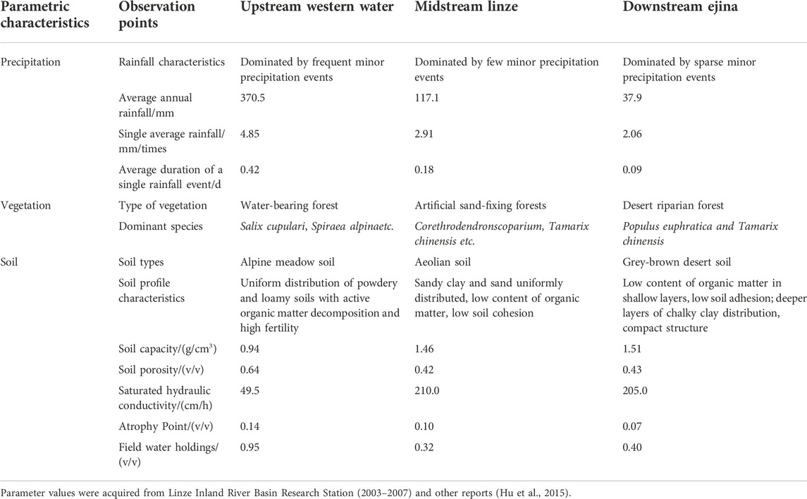
TABLE 1. Characteristics of precipitation, vegetation, and soil in typical landscape belts in upper, middle, and lower reaches of Heihe river basin.
Soil moisture investigation and statistical analysis
Between 2003 and 2007, the ENVIS system (IMKO, Germany) was installed at the three study sites in the upper, middle, and lower reaches of the Heihe river basin, wherein the following types of instruments and sensors were installed—net radiation: TYPE 8110 (Wein GmbH & Co. KG, Austria), air pressure: PTB100 (Vaisala, Finland), geothermal fluxes: HFT-3 and HFP01 (Campbell, Britain), wind speed and direction: RITA and LISA (Siggelkow Geratebau, Germany), and soil moisture: Soil Moisture Observation Tube (TRIME-TDR, IMKO, Germany). As the results of the TRIME-TDR are influenced by the tightness of the contact between the tube wall and soil, the installation procedure was performed strictly according to the installation instructions. Moreover, the field measurements of the TDR under various moisture conditions were compared with those obtained by drying the soil auger samples. Thereafter, the soil moisture profiles were measured at depths of 0–160 cm (0–20, 20–40, 40–60, 60–80, 80–120, and 120–160 cm). For each observation site, the hourly readings of data were acquired from 2003 to 2007 (43,800 h of observations). The average of the 24 h readings was accounted as the daily volumetric soil-moisture content of the layer. Compared to the traditional soil auger and drying methods, the proposed method offers a rapid and intuitive approach, does not require soil sampling, involves no lag period, and automatically records data. More importantly, it is more accurate, less affected by environmental variations, and can be considered suitable for continuous field observations at fixed points. However, the accuracy of soil measurements can be affected by the possible presence of a frozen layer in the surface and shallow layers of the soil in winter (dielectric constant of liquid water varies considerably from that of frozen water) such that the soil moisture data in this study only exhibit variations in soil liquid moisture and do not include soil solid moisture. Preliminarily, the observed data was preprocessed using Excel 2010. Thereafter, one-way ANOVA was performed on soil moisture using SPSS 21.0, and the plots were created using Origin 8.0.
Equation for evaluating soil water storage:
where SWS denotes the water storage capacity of the 0–160 cm soil layer (mm), θi denotes the volumetric water content of the soil in layer i (cm3/cm3), Hi indicates the soil layer thickness in layer i (cm), i = 1,2,3,..., and n denotes the soil profile stratification number (Zhao et al., 2009).
The coefficient of variation of soil moisture can be evaluated as follows:
where CV represents the coefficient of variation, SD denotes the standard deviation, and m refers to the sample mean.
Results
Characteristics of soil moisture dynamics at 0–160 cm layer across various landscapes
The evident soil stratification in the upper mountain vegetation zone varied similarly across depths of 0–20, 20–40, 40–60 and 60–80 cm, and the fluctuations observed at depths of 80–120 and 120–160 cm were more similar than those at the other studied depths. Although the soil water content fluctuated and increased at depths of 20–40, 40–60, and 60–80 cm, that at 120–160 cm was more stable (Figures 2a1–f1). Notably, the soil moisture fluctuations in the 0–160 cm layers of the midstream desert oasis margin were similar to those in the artificial sand-fixation forest zones, with no prominent stratification and an overall increasing trend of the volumetric soil moisture content (Figures 2a2–f2). In the lower desert riparian forest zone, the soil stratification was evident with similar variations across the layers of 0–20, 20–40, 40–60, and 60–80 cm, whereas the fluctuations at depths of 80–120 and 120–160 cm were more consistent, with a decreasing trend of volumetric soil moisture content from 0 to 80 cm. Despite the more stable soil moisture content in the 80–160 cm layer, the duration of high soil moisture values diminished (Figures 2a3–f3).

FIGURE 2. Soil moisture content at various soil depths (monthly mean). Note: a, b, c, d, e, and f indicate 0–20, 20–40, 40–60, 60–80, 80–120, and 120–160 cm, respectively.
Characteristics of soil moisture at 0–160 cm layers across various landscape zones with varying seasonal scales
In the upper mountainous vegetation zone, the soil moisture content typically increased in both the non-growing and growing seasons, with a generally higher soil moisture in the growing season than in the non-growing season (0.77–17.08%). However, this content fluctuated more significantly in the growing season, especially in the 0–80 cm soil layer (Figure 3A). In the middle reaches of the desert oasis, the soil moisture content in the growing season was 0.43–4.02% higher than that in the non-growing season and increased significantly from 2005 to 2007. In this region, the soil moisture content increased in the non-growing and growing seasons, especially in the 40–60 cm range (Figure 3B). In the downstream, the soil water content in the growing season was lower than in the non-growing season, especially from 0 to 20 cm depth (Figure 3C).
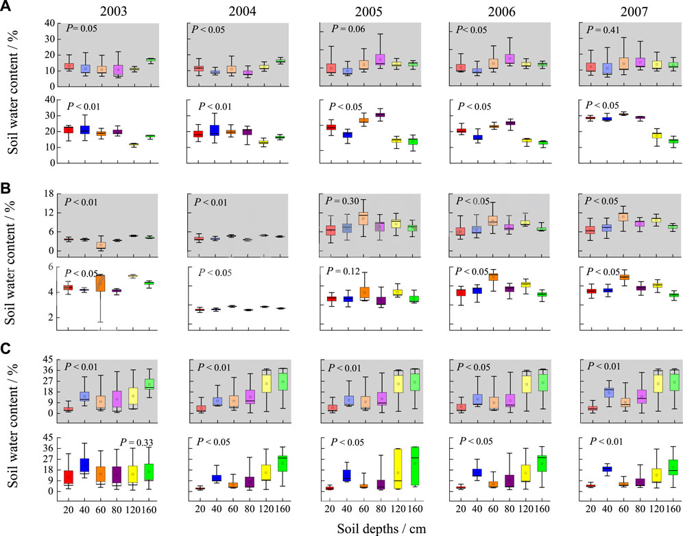
FIGURE 3. Soil moisture contents at various soil depths in non-growing and growing seasons (monthly mean ± standard deviation). Note: (A–C) represent upstream mountain vegetation zone, midstream artificial shrubbery of desert oasis transition zone, and downstream desert riparian forest zone, respectively. Gray background represents non-growing season (January–April, October–November), whereas white background represents growing season (May–October).
Characteristics of soil moisture profiles in various landscape zones
The soil moisture distribution characteristics of diverse landscape zones varied significantly, with the highest fluctuations observed in the upstream mountain vegetation zone at depths of 0–80 cm. However, the fluctuations in the soil moisture diminished at depths of 80–160 cm, and the soil moisture in the former range was higher than that in the latter range (Figure 3A). In the planted shrub forest situated in the midstream desert oasis transition zone, the soil moisture distribution was uniform with a more consistent trend and magnitude of variations in soil moisture (Figure 3B) compared to that of other regions. Although the moisture content across various soil layers in the downstream desert riparian forest zone remained consistent at depths of 0–80 cm, its trend was more consistent in the range of 80–160 cm (Figure 3C).
Characteristics of soil water storage in various landscape zones
In terms of intra-annual variation across the 0–160 cm layers of the planted shrubland in the upstream mountain vegetation zone and the midstream desert oasis-transition zone, the soil water content initially increased before decreasing, and all the high values were observed during the growing season. In general, the growing season exhibited higher mean values (272.23–358.14 mm upstream and 74.67–178.9 mm midstream) than the non-growing season (181.71–209.01 mm upstream and 60.15–178.9 mm downstream). However, the soil water content fluctuated considerably in the 0–160 cm layers of the lower desert riparian zone, with high values existing across April–May or September–October. Overall, the mean values ranged from 234.81 to 293.09 mm in the non-growing season and 209.63–248.65 mm in the growing season (Figure 4, Figure 5). More specifically, the inter-annual variability in soil water storage significantly increased during the growing season in the upstream mountainous vegetation zone. Although a similarly significant upward trend was observed in the midstream desert oasis edge plantation shrubland, the downstream soil water storage displayed a downward trend during the growing season (Figure 4).
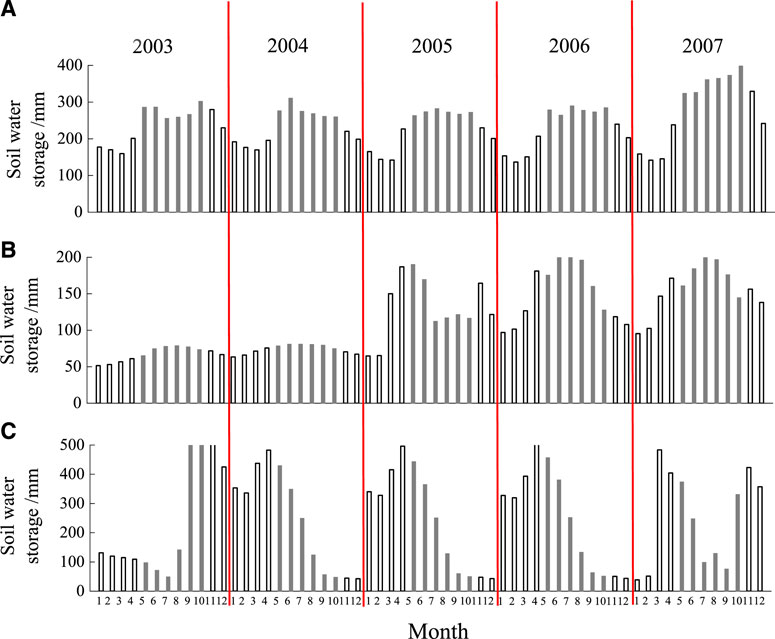
FIGURE 4. Monthly variations in soil water storage. Note: (A–C) represent upstream mountain vegetation zone, midstream artificial shrubbery of desert oasis transition zone, and downstream desert riparian forest zone, respectively. White columns represents non-growing season (January–April, October–November), whereas gray columns represents growing season (May–October).
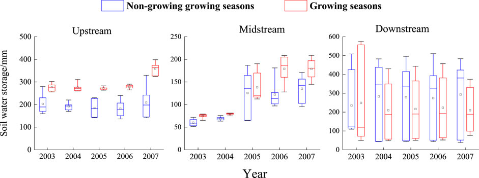
FIGURE 5. Soil water storage during non-growing and growing seasons.
Variability characteristics of soil moisture in different landscapes
The coefficient of variation of soil moisture content across all studied regions is stated as follows: the vertical distribution exhibited a declining trend with increasing soil depth in the upper mountain vegetation zone, with the maximum and minimum coefficients of variation observed at the layers of 20–40 cm and 120–160 cm (0.07–0.24), respectively. The coefficient of variation of soil moisture content in the planted shrubland at the edge of the midstream desert oasis displayed a diminishing trend, with the maximum values occurring mainly at 0–20 cm and the minimum values at 120–160 cm. Although this trend initially decreased for the lower desert riparian zone, it subsequently increased, with the smallest coefficient of variation (0.39–0.64) in the 20–40 cm layer and the largest coefficient of variation in the 60–80 cm layer (Table 2). In terms of the coefficient of variation of soil water storage, the shrub forests planted in the upper mountainous vegetation zone and midstream desert oasis-transition zone exhibited higher values during the non-growing season (0.09–0.36 and 0.06–0.41) than during the growing season (0.02–0.08 and 0.03–0.24), whereas values in the desert riparian zone were higher during the growing season (0.60–1.00) than during the non-growing season (0.67–0.77). The highest coefficient of variation in soil water storage was observed in the downstream riparian forest, followed by the midstream, and lastly, the upstream regions (Table 3).
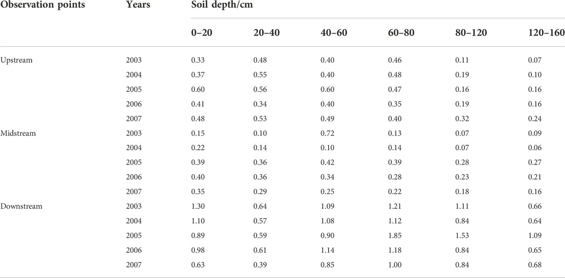
TABLE 2. Variation coefficient of soil moisture content.
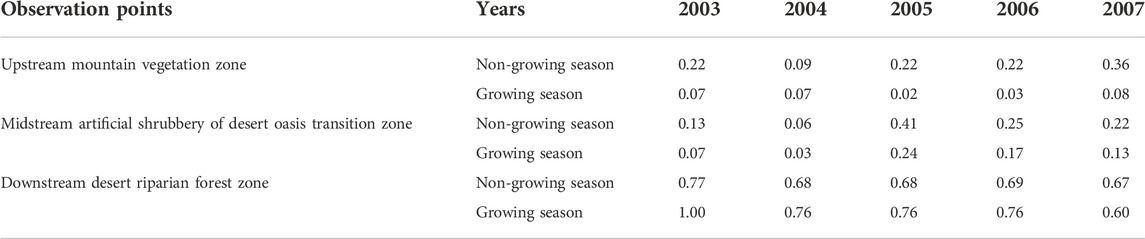
TABLE 3. Variation coefficient of soil water storage.
Discussion
Temporal dynamics of soil moisture in different landscapes
In this study, the temporal dynamics of soil moisture at depths of 80–160 cm across various landscapes displayed an increased trend. Notably, the seasonal cyclic characteristics of the soil moisture content were prominent in the upstream regions—low moisture content during the non-growing season and high content during the growing season (precipitation season), suggesting that the soil moisture followed the rainfall pattern. Interestingly, these fluctuations were much more evident in the 0–80 cm layer than in the 80–160 cm layer, implying that most precipitation events could primarily infiltrate and recharge the layer at 0–80 cm depth. This is because minor precipitation events of 5 mm rainfall were the dominant precipitation events in the upstream. In the midstream, the sand soils facilitated a higher infiltration rate but exhibited lower water retention capacity. Thus, the soil moisture rapidly increased to the field-holding capacity after precipitation. After implementing the water diversion scheme, the amount of water present in the oasis edge increased, and over time, the soil water content consequently increased. In the downstream, the soil moisture in the deep layers (80–120 and 120–160 cm) remained high for a long period owing to the stable recharge from the river water after the water diversion scheme. However, the soil moisture in the shallow layer (0–80 cm) decreased owing to the increased vegetation cover. Although the soil moisture content was high during the occurrence of floods, it declined when the floods receded. Mohanty et al. (2001) reported that the moisture content of sandy loam soil exhibits a stronger temporal stability than that of chalk loam soil. Jacobs et al. (2004) determined that soils with a moderate clay content (28–30%) are more stable. Hu et al. (2010) revealed the significantly high temporal stability of sandy soils compared to that of sandy loam and chalk loam soils. In contrast, this study determined that the temporal dynamic characteristics of soil moisture are influenced by several factors, e.g., soil properties and hydrological factors, rather than the singular soil texture.
This study determined that the soil moisture characteristics remained consistent in the upstream but varied significantly in the midstream and downstream regions, with relatively consistent fluctuation patterns. In the inland river basins of arid regions, the primary water resources of soil moisture include precipitation, river water, and groundwater. As the temperature rises during the growing season, the melting snow and ice increases the soil water content, especially at the upstream (Hu et al., 2010). In addition, the amount of water stored in the soil was higher than that undergone transevaporation. Consequently, the soil moisture status was enhanced with higher soil water content. These results are consistent with those of other studies conducted in the Qinghai spruce forests situated in this upstream region (Lu et al., 2020; Fan Limei, 2015). In the midstream, precipitation mainly occurs during the growing season (Zhang Kehai, 2020), and thus, soil moisture remains at a stable and high level (Liu et al., 2002; Wang et al., 2015). In the downstream, the climate is extremely arid with strong evaporation (Zhao et al., 2008), and the primary sources of soil moisture include surface runoff and groundwater (Fu et al., 2014). Although the soil moisture at greater depths is regulated by both river recharges and soil texture, the variations in the soil moisture content at depths of 0–80 cm are predominantly affected by the vegetation cover and soil texture.
Profile characteristics of soil moisture
The present findings revealed the stratified soil-moisture content in the upper mountainous regions, with significant variations between the layers of 0–80 and 80–160 cm. This phenomenon of soil moisture stratification reflects the vertical spatial heterogeneity of the soil, affected by soil texture. In the middle stream, the soil moisture displayed similar trends with homogeneous soil texture among the 0–160 cm layers. In the downstream, the variations in soil moisture are similar across the 0–80 cm layers and those of the 80–160 cm layer bear their own unique similarity. In the upstream, the soil moisture content was higher in 0–80 cm layers than in 80–160 cm layers. However, the spatial distribution characteristics of soil moisture indicate a contrasting pattern in the downstream. Thereafter, the soil moisture tends to stabilize in the midstream. The precipitation events during the growing season affected the shallow layer of 40–60 cm, which is covered by the primary distribution zone of vegetation roots (Sheng et al., 2004; Zhu et al., 2017) (Burgess et al., 1998; Schulze et al., 1998). In the arid regions, the precipitation events mainly included small precipitation events that failed to recharge the soil moisture content in the 80–160 cm layers (Zhang et al., 2020).
Furthermore, the results indicated significant differences between the variability of soil moisture across the vertical profiles of the three landscape zones. In the upstream and midstream, the least variability in soil moisture was observed in the deep layers of 120–160 cm, whereas in the downstream area, the lowest variability was recorded mainly within the shallow layer of 40–60 cm. Moreover, the highest coefficient of variation in the upstream and midstream was observed primarily in the shallow layers of 20–60 cm but that in the downstream areas occurred majorly in the 60–80 cm layer. The variations in soil moisture differed significantly across the vertical profiles of the three different landscapes. The vertical variation in soil moisture was relatively small in the upstream and midstream, i.e., relatively homogeneous distribution of soil moisture in the soil profile. In contrast, the soil moisture in the downstream desert riparian forest zone exhibited a relatively more heterogeneous distribution. These variations highlight the strong dependence of soil moisture on the local soil and hydrological conditions.
For instance, the coefficient of variation in soil moisture is large in the shallow layers of upstream mountain vegetation zone. In particular, the soil moisture in the shallow 0–40 cm layer is significantly influenced by precipitation, which promotes active soil-moisture exchange that rapidly increases during rain but drastically reduces post-rainfall (Fan Limei, 2015). In contrast, the soil layer of 80–160 cm is less affected by frequent minor precipitation events. Notably, the coefficient of variation is smaller in the 80–160 cm soil layer, because it is less affected by frequent low rainfall under the prevailing weak evaporation (Zhao et al., 2016) and, therefore, bears a higher water-retention capacity. These results signify that the soil moisture in the surface or shallow layers acts the usual source of water for vegetation growth and is strongly influenced by precipitation infiltration and evapotranspiration whereas that in deeper layers serves as a “soil reservoir.” The greatest variability in soil moisture in the downstream desert riparian zone was observed in the middle layer (60–80 cm), which may be influenced by intermittent flood recharge. Overall, the variable flow of river may be the primary factor of soil moisture variability.
Ran et al. (2009) analyzed the temporal stability of soil moisture in the Black River basin and concluded that surface soil moisture was unstable and largely stable below 40 cm. Heathman et al. (2009) analyzed the temporal stability of soil moisture in the southern Great Plains region of the United States and reported that soil moisture is less stable in the surface layer than that in the profile of most areas. However, the diversity of landscapes and the complexity of factors affecting the temporal stability of soil moisture in arid inland river basins, including the strong dependence of soil moisture dynamics on seasons, layer depth, and topography, create challenges in establishing a uniform evaluation system based on the results of these studies. This is particularly true in the absence of heterogeneity or homogeneity of potential control factors that impact the temporal stability of soil moisture.
Characteristics of soil water storage changes
The soil water storage across the diverse landscapes of the Heihe River Basin displayed evident seasonal characteristics. In particular, the soil water storage is high and less variable during the growing season in the upstream and midstream, whereas it is high and most variable in the nongrowing season in the downstream, which is consistent with the results of Brocca et al. (2007). Overall, the results are highly consistent with the Heihe River Diversion Scheme, which transports extensive amounts of water to the extremely dry downstream areas to raise the water table and restore vegetation. However, in terms of soil moisture storage, soil moisture is still relatively low in the downstream during the growing season (especially from July to September).
Conclusion
This study objectively determined the variability in the spatial and temporal characteristics of soil moisture in the three typical landscape zones of the Heihe River Basin. At the temporal scale, the upstream mountain vegetation zone and the midstream desert oasis-transition zone with planted shrub forests manifest a greater temporal stability in soil moisture content, with large differences between the growing and non-growing seasons. In contrast, the downstream desert riparian forest zone is less stable over time and exhibits high soil-moisture variability. The vertical distribution of the soil profile of the upstream mountainous vegetation zone revealed sharp fluctuations in the surface layer (0–20 cm), relatively high stability in the middle layer (20–80 cm), and high stability in the deep layer (80–120 cm). This indicates that the soil moisture in the upstream region is primarily influenced through precipitation, evaporation, and evapotranspiration. In the middle reaches of the desert oasis margins, the artificial shrub forests are characterized by a dry sand layer (0–40 cm) on the surface, a high-water-content layer (40–60 cm) in the middle, and a low-water-content layer (80–160 cm) in the deep. In the downstream desert riparian forest zone, the soil moisture content variability is low within the surface and middle layers (0–80 cm) and high in the deeper layers (80–160 cm); however, the middle layer is influenced by precipitation and evaporation as well as the river water influx.
Data availability statement
The original contributions presented in the study are included in the article/Supplementary Material, further inquiries can be directed to the corresponding author.
Author contributions
QG and WG wrote the manuscript. GW designed the experiment and performed manuscript review. YL and JL provided assistance for data analysis. QG and WG contributed equally to this study. All authors contributed to the article and approved the submitted version.
Funding
This research was funded by the National Natural Science Foundation of China (Grant Nos. 42171033, 41807518, and 41701045), Shanxi Provincial Natural Science Foundation of China (Grant No. 201801D221336), and Scientific and Technological Innovation Programs of Higher Education Institutions in Shanxi (Grant Nos. 2019L0457, 2019L0463).
Acknowledgments
We are grateful to John B. Bradford and Baoli Liu for their insights and suggestions on this study.
Conflict of interest
The authors declare that the research was conducted in the absence of any commercial or financial relationships that could be construed as a potential conflict of interest.
Publisher’s note
All claims expressed in this article are solely those of the authors and do not necessarily represent those of their affiliated organizations, or those of the publisher, the editors and the reviewers. Any product that may be evaluated in this article, or claim that may be made by its manufacturer, is not guaranteed or endorsed by the publisher.
Supplementary material
The Supplementary Material for this article can be found online at: https://www.frontiersin.org/articles/10.3389/fenvs.2022.1049883/full#supplementary-material
References
Brocca, L., Morbidelli, R., Melone, F., and Moramarco, T. (2007). Soil moisture spatial variability in experimental areas of central Italy. J. Hydrology 333 (2-4), 356–373. doi:10.1016/j.jhydrol.2006.09.004
Burgess, S. S. O., Adams, M. A., Turner, N. C., and Ong, C. K. (1998). The redistribution of soil water by tree root systems. Oecologia 115 (3), 306–311. doi:10.1007/s004420050521
Chang, Xueshang, and Chang, Guoqiao (2021). Advances in research and prospect on soil moisture in arid and semi-arid areas. J. Desert Res. 41 (1), 156–163.
Cheng, Lipin, Liu, Wenzhao, and Zhi, Li (2014). Soil water in deep layers under different land use patterns on the Loess Tableland. Acta Ecol. Sin. 34 (8), 1975–1983.
Curreli, A., Wallace, H., Freeman, C., Hollingham, M., Stratford, C., Johnson, H., et al. (2013). Eco-hydrological requirements of dune slack vegetation and the implications of climate change. Sci. Total Environ. 443, 910–919. doi:10.1016/j.scitotenv.2012.11.035
Fan, Limei (2015). Study on hydrological function of forest and vegetation in the pailugou catchment, qilian mountains. Lanzhou: Gansu Agricultural University.
Fu, Aihong, Chen, Yaning, and Li, Weihog (2014). Water use strategy of desert riparian forest plant communities in the lower reaches of Heihe River in China. Sci. Sin. (Terrae) 44 (4), 693–705.
Heathman, G. C., Larose, M., Cosh, M. H., and Bindlish, R. (2009). Surface and profile soil moisture spatio-temporal analysis during an excessive rainfall period inthe Southern Great Plains, USA. Catena 78, 159–169. doi:10.1016/j.catena.2009.04.002
Hu, L., Wenzhi, Z., Zhibin, H., and Liu, J. (2015). Soil moisture dynamics across landscape types in an arid inland river basin of Northwest China. Hydrol. Process. 29 (15), 3328–3341. doi:10.1002/hyp.10444
Hu, W., Shao, M. G., Wang, Q. J., and Reichardt, K. (2009). Time stability of soil water storage measured by neutron probe and the effects of calibration procedures in a small watershed. Catena 79 (1), 72–82. doi:10.1016/j.catena.2009.05.012
Hu, W., Shao, M. G., Han, F. P., Reichardt, K., and Tan, J. (2010). Watershed scale temporal stability of soil water content. Geoderma 158, 181–198. doi:10.1016/j.geoderma.2010.04.030
Jacobs, J. M., Mohanty, B. P., Hsu, E. C., et al. (2004). SMEX02: Field scale variability, time stability and similarity of soil moisture. Remote Sens. Environ. 92 (4), 436–446. doi:10.1016/j.rse.2004.02.017
Jia, Y. H., and Shao, M. A. (2014). Dynamics of deep soil moisture in response to vegetational restoration on the Loess Plateau of China. J. Hydrology 519 (Pt), 523–531. doi:10.1016/j.jhydrol.2014.07.043
Jiang, Zhicheng, Jiang, Zhiren, Zhao, Weijun, et al. (2021). Study on the variation characteristics of grassland vegetation soil water potential in xishui forest area of qilian mountains, Gansu. J. Southwest For. Univ. 41 (2), 177–181.
Liu, Famin, Zhang, Yinghua, Wu, Yanqing, et al. (2002a). Soil water regime under the shrubberies of haloxylon ammodendron in the desert regions of the Heihe river watershed. Arid Zone Res. 19 (1), 27–31.
Liu, Peiling, Chen, Le, Liu, Xiaodong, et al. (2021). Temporal and spatial variability of soil moisture in a forest succession series in Dinghushan. Acta Ecol. Sin. 41 (5), 1798–1807.
Lu, Qian, Yi, Li, Liu, Xiande, et al. (2020). Soil moisture variation characteristics of Picea crassifolia forestry in pailugou watershed of qilian mountains. J. Desert Res. 40 (5), 142–148.
Ma, Xiaodong, Li, Weihong, Zhu, Chenggag, et al. (2010). Spatio-temporal variation in soil moisture and vegetation along the lower reaches of Tarim River, China. Acta Ecol. Sin. 30 (15), 4035–4045.
Mohanty, B. P., and Skaggs, T. H. (2001). Spatio-temporal evolution and time-stable characteristics of soil moisture within remote sensing footprints with varying soil, slope and vegetation. Adv. Water Resour. 24 (9/10), 1051–1067. doi:10.1016/s0309-1708(01)00034-3
Ran, Youhua, Xin, Li, Wang, Weizhen, et al. (2009). Grid scale temporal stability of multi-layer soil moisture in a grassland ecosystem in western China. Adv. Earth Sci. 24 (7), 817–824.
Schulze, E-D., Caldwell, M. M., Canadell, J., Mooney, H. A., Jackson, R. B., Parson, D., et al. (1998). Downward flux of water through roots (i.e. inverse hydraulic lift) in dry Kalahari sands. Oecologia 115 (4), 460–462. doi:10.1007/s004420050541
Sheng, Jinhua, Qiao, Yongxiang, Liu, Hongyi, et al. (2004). A study on the root system of haloxylon aammodendron (C.A.mey.) bunge. Acta Agrestia Sin. 12 (2), 91–94.
Song, Kechao, Kang, Eesi, Lan, Yongchao, et al. (2003). Synchronous measurement of land surface processes in typical vegetation landscape zones in the hei river basin. J. Glaciol. Geocryol. 25 (5), 552–557.
Suo, Lizhu, Hung, Mingbing, Duan, Liangxia, et al. (2017). Zonal pattern of soil moisture and its influencing factors under different land use types on the Loess Plateau. Acta Ecol. Sin. 37 (6), 2045–2053.
Wang, Jiaqiang, Liu, Weiyang, Peng, Jie, et al. (2017). Distribution of desert riparian forest soil water and shallow groundwater in upstream basin of Tarim River. Southwest China J. Agric. Sci. 30 (9), 2071–2077.
Wang, Y. Q., Ma, J. Z., Zhang, Y. L., Zhao, M., and Edmunds, W. M. (2013). A new theoretical model accounting for film flow in unsaturated porous media. Water Resour. Res. 49 (8), 5021–5028. doi:10.1002/wrcr.20390
Wang, Yanli, Liu, Lichao, Gao, Yanhong, et al. (2015). Dynamic and spatial distribution of soil moisture in an artificially Re-vegetated desert area. J. Desert Res. 35 (4), 942–950.
Zhang, Kehai (2020). Soil moisture dynamics of different landscape types in the middle reaches of Heihe river. Lanzhou: Lanzhou Jiaotong University.
Zhao, Jun, Ren, Haochen, Zhao, Chuanyan, et al. (2009). The study of the soil moisture retrieval and effects of different land-use types in Heihe River Basin. J. Arid Land Resour. Environ. 23 (8), 139–144.
Zhao, L. W., and Zhao, W. Z. (2014). Water balance and migration for maize in an oasis farmland of northwest China. Chin. Sci. Bull. 59, 4 829–4837. doi:10.1007/s11434-014-0482-4
Zhao, Liangjv, Xiao, Honglang, Cheng, Guodong, et al. (2008). A preliminary study of water sources of riparian plants in the lower reaches of the Heihe basin. Acta Geosci. Sin. 29 (6), 709–718.
Zhao, Yonghong, Liu, Xiande, Zhang, Xelong, et al. (2016). The spatial distribution and monthly variation of soil moisture of sub-alpine shrubs in qilian mountains. J. Nat. Resour. 31 (4), 672–681.
Zheng, Lu, Han, Menglei, Lu, Hui, et al. (2020). Estimating soil moisture in the middle and upper reaches of the Heihe river basin based on AMSR2 multi-brightness temperature. Remote Sens. Technol. Appl. 35 (1), 33–47.
Keywords: inland river basin, landscape zones, soil moisture, dynamic change, spatial differentiation regularity
Citation: Gou Q, Guo W, Li Y, Liu J and Wang G (2022) Dynamic changes in soil moisture in three typical landscapes of the Heihe River Basin. Front. Environ. Sci. 10:1049883. doi: 10.3389/fenvs.2022.1049883
Received: 21 September 2022; Accepted: 04 November 2022;
Published: 18 November 2022.
Edited by:
Ning Chen, Lanzhou University, ChinaReviewed by:
Ping Wang, Institute of Geographic Sciences and Natural Resources Research (CAS), ChinaHai Zhou, Northwest Institute of Eco-Environment and Resources (CAS), China,
Xueli Chang, Ludong University, China
Copyright © 2022 Gou, Guo, Li, Liu and Wang. This is an open-access article distributed under the terms of the Creative Commons Attribution License (CC BY). The use, distribution or reproduction in other forums is permitted, provided the original author(s) and the copyright owner(s) are credited and that the original publication in this journal is cited, in accordance with accepted academic practice. No use, distribution or reproduction is permitted which does not comply with these terms.
*Correspondence: Guohua Wang, Z2ltaTEyM0AxMjYuY29t