 Honglei Wang
 Lijuan Shen
 Junke Zhang
 Xinyao Xie
 Xiaobin Guan
94% of researchers rate our articles as excellent or good
Learn more about the work of our research integrity team to safeguard the quality of each article we publish.
Find out more
EDITORIAL article
Front. Environ. Sci., 06 September 2022
Sec. Atmosphere and Climate
Volume 10 - 2022 | https://doi.org/10.3389/fenvs.2022.1014003
This article is part of the Research TopicAir Pollution Remote Sensing and the Subsequent Interactions with Ecology on Regional ScalesView all 31 articles
Editorial on the Research Topic
Air pollution remote sensing and the subsequent interactions with ecology on regional scales
With the rapid increase of global population and urbanization, the impact of human activities on the earth’s ecological environment has become increasingly serious. Human beings are currently facing unprecedented atmospheric environmental challenges, such as the polar ozone (O3) hole, global warming, haze and photochemical pollution, etc. Air pollution, defined as the release of pollutants into the atmosphere, has been regarded as one of the greatest environmental problems that closely related to our lives due to its significant impacts on the environment and human health. Fortunately, in recent decades, we have deeply realized the harm of air pollution, and the related detection technology and treatment methods have also been greatly improved. In particular, the development of remote sensing, such as radar and satellite, has greatly enhanced our understanding of the spatiotemporal, transmission mechanism, and formation mechanism of air pollution.
Air pollution events near the ground, such as sandstorms, acid rain, haze and O3 pollution, etc., can cause great harm to buildings, vegetation, and human health. Generally, the occurrence of these air pollutions has an extensive spatial range and a very random timing. Previous site-based studies can only represent very local information, and there are few long-term continuous observations. As an important approach of monitoring the large-scale atmospheric condition, remote sensing plays a significant role in characterizing the temporal and spatial distributions of air pollution, as well as its multiple feed-back effects on the ecosystem. The continually improved spatial resolution of sensors acts as a key component to satisfy the description of the pollution-ecology interactions at a regional or the global scale. In turn, the changes in ecosystem and atmospheric environment also influence the budget and chemistry of air pollutants and remote sensing monitoring. Numerous studies have confirmed that air pollution can affect the vertical structure of the atmosphere, the optical properties of the aerosol, the acidity and alkalinity of water and soil, precipitation and solar radiation, etc., which affects the accuracy of remote sensing observations and the ecological environment.
In general, an adequate understanding and an improved representation of these complex interactions are crucial for air pollution control, climate change mitigation, and ecosystem restoration. To fully understand these interaction mechanisms requires a large amount of monitoring data (ground, aircraft, and satellite) and various models (box, regional, and global models). This Research Topic aims to cover all theoretical, observational, experimental, and modeling studies that present new knowledge of air pollution, remote sensing, and pollution-ecology interactions at the regional scale, such as the study of air pollution in central China (Figure 1).
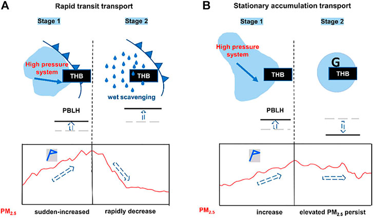
FIGURE 1. Diagram of meteorological mechanism on regional PM2.5 transport with the typical patterns of (A) rapid transit transport (RTT) and (B) stationary accumulation transport (SAT) driving the PM2.5 concentration changes (bottom line graphs) for heavy air pollution over the Twain-Hu Basin (THB) revealed in this study. Adapted from Wang et al.
This Research Topic collected a total of 29 papers, which can be mainly divided into the following five areas. ①Regional air pollution, a total of 9 papers, covering O3 pollution, PM2.5 pollution, aerosol chemical composition and particle size distribution, etc.②Remote sensing observations and model simulations of meteorological conditions, a total of five papers, including precipitation, urban heat islands, typhoons, aerosol radiative effects, etc.③Aircraft observations, a total of three papers, mainly associated with aircraft remote sensing measurement technology in precipitation and cloud microphysical structure. ④Lightning remote sensing and model simulations, a total of seven papers, mainly related to lightning discharge mechanism, spatiotemporal distribution, and the interaction between lightning and aerosol, meteorological elements and ecological environment, etc. ⑤ Remote sensing and pollution-ecology interactions at the regional scale, a total of five papers, mostly correlated with the application of remote sensing technology in the ecological environment and the interaction between air pollution and the ecological environment, etc.
In cities, air pollution is mainly dominated by particulate matter and O3 pollution. The most typical cases are the Great Smog of London event and the Los Angeles photochemical smog event. In recent years, more and more regions have suffered from air pollution, such as the Yangtze River Delta (YRD) and the Pearl River Delta (PRD) in China. Xie et al. investigated the spatiotemporal variability of air stagnation in summer as well as its relation to summer O3 over YRD region of China. They found that air stagnation days (ASDs) in the YRD during the summers from 2001 to 2017 range from 9 to 54 days (9.2–58.4% of the entire summer days). According to the empirical orthogonal function (EOF) analysis, they also assessed the dominant weather systems affecting air stagnation in the YRD. Based on the observation data of environmental and meteorological stations in the nine cities of PRD in 2019, Yu et al. investigated the variations of secondary PM2.5 (PM2.5-sec) in the PRD under different photochemical reactivity backgrounds. Results showed that the average maximum concentration of each pollutant appeared higher for polluted stations than for clean ones, indicating that the atmospheric oxidation background was conducive to the formation of PM2.5-sec. Using the gaseous pollutants, the 9 sizes of segregated particles, and water-soluble inorganic ions (WSII) data, Wu et al. investigated the size distribution of WSII during the rain period (Meiyu) in the East Asian summer monsoon season. They suggested that the WSII mass concentration peaks at a particle size of 1.1–2.1 μm for fine particles, while at 5.8–9.0 μm (before the Meiyu onset) and 9.0–10.0 μm (during the Meiyu period) for coarse particles, respectively. Mamtimin et al. analyzed the impacts of winter and summer COVID-19 lockdowns on urban air quality in Urumqi, Northwest China. Based on ground and satellite observations, they assessed the impacts of these lockdowns on the air quality in Urumqi and the seasonal differences between them. Liu et al. studied the uncertainty of premature death estimation under various open PM2.5 datasets.
Wang et al.analyzed the temporal and spatial patterns of air pollution and the heterogeneity of its influencing factors in central Inner Mongolia from 2016 to 2018. As Inner Mongolia is one of the primary sources of dust in North China, they used multiple auxiliary variables and the geographically weighted regression to estimate the spatial distribution of PM2.5 concentration, and further characterized the socioeconomic determinants of PM2.5 concentration by geographic detectors. There are also three papers that provide an in-depth analysis of haze pollution in central and eastern China. Yu et al. studied a unique case of joint occurrence of heavy PM2.5 pollution episodes and persistent foggy days in central east China. Based on hourly data of ground level meteorological parameters, PM2.5 data and CALIPSO-based (the Cloud-Aerosol Lidar and Infrared Pathfinder Satellite Observation) aerosol data, combined with ECMWF (European Centre for Medium-Range Weather Forecasts) reanalysis data and radiosonde temperature profile, they revealed the meteorological reasons for the evolution of the episode at horizontal and vertical scales. Liu et al. and Wang et al. made great efforts to establish conceptual models for typical fog-haze processes. Liu et al. adopted the characteristics of atmospheric circulations and boundary layer dynamic conditions to develop a movable boundary layer conceptual model for the Jianghuai area in the winter half of the year. This conceptual model was validated to well explain the causes of air quality change and frequent fog-haze episodes. Results also suggested that variations of the intensity and range of the cold and warm fronts in the winter half of the year lead to form a movable boundary in the Jianghuai area. Wang et al.identified two distinct patterns of regional transport named rapid transit transport (RTT) and stationary accumulation transport (SAT), both of which induced severe PM2.5 pollution episodes in central China from 2015 to 2020. Using influencing meteorological factors, they summarized the differences and similarities between the two regional transport patterns of air pollution.
Besides the emission sources, meteorological conditions are the most important influencing factors of regional air pollution. With the development of remote sensing technology and numerical models, it is now possible to carry out detailed and in-depth research on the spatial and temporal distribution, influence area, influence degree and formation mechanism of regional meteorological conditions. Using remote sensing and geodetector, Xiong et al. analyzed long time-series urban heat island (UHI) monitoring and driving factors from 2000 to 2018. Their study mainly focused on the impact of land cover type and landscape metric factors on surface temperature. Urban et al. used google street view photographs to assess the long-term outdoor thermal perception and thermal comfort in the urban environment during heatwaves. In this study, they proposed an approach to the assessment of long-term thermal perception that combines features of currently used methods (i.e., rating scales of thermal perception, surveys, and photographs representing places) and they provided some preliminary validation of this approach. Based on hourly gridded precipitation data (0.1°) calculated by the China Meteorological Administration (CMA), ECMWF data, and microwave measurements, Zhu et al.investigated the extreme precipitation induced by the Typhoon Maysak in Northeast China (September 2020). Their study focused on Changbai Mountain topography and the extreme precipitation in Jilin Province. Hao et al. studied impacts on meteorological parameters and pollutants by aerosol direct radiative effect over Tianjin, China. Sun et al. studied the effects of relative humidity on the diurnal variation of raindrop size distribution in southwest China.
The aircraft observation platform could provide detailed three-dimensional (3D) information of ecosystem and atmospheric environment within a few km of the ground. Aircraft observations can directly obtain 3D atmospheric physics and atmospheric chemistry information, and can also verify remote sensing observations and numerical model results. In China, numerous studies of aircraft observation experiments have been carried out for precipitation, cloud physical chemistry and air pollution. Three papers looked closely at the aircraft measurement. Huang et al. studied the vertical structure of a snowfall event based on observations from the aircraft and mountain station in Beijing. In this study, an aircraft platform, ground-based dendrometers, cloud radar, radiometer, and automatic station were combined to study a snowfall case on the Yangqing Mountains in Beijing. Dong et al.showed the aircraft observation of a two-layer cloud and the analysis of cold cloud seeding effect. King-air 350 meteorological aircraft was designated to acquire the microphysical characteristics of this cloud. Yang et al. investigated the response of mixed-phase cloud microphysical properties to cloud-seeding near cloud top over Hebei, China. Their findings suggested that the cloud microphysical properties showed obvious responses to the artificial introduction of silver iodide, which was important for human weather modification.
Lightning is a natural phenomenon of strong discharge, and its high-temperature and high-brightness discharge characteristics can affect atmospheric chemical processes, such as producing a large amount of LNOx, which affects the concentration of O3 in the atmosphere. In addition, the lightning also causes wildfires, and the strong discharge cause harm to human and animals. Lightning is often accompanied by strong convection processes. Severe convection and lightning often occur in the world, and the lightning activities may cause great economic losses and social impact. Jin et al.studied lightning disaster risk zoning in Jiangsu province of China based on the analytic hierarchy process and entropy weight method. They investigated the risk of hazard factors, the sensitivity of hazard-pregnant environment, and the frangibility of a hazard-bearing body in Jiangsu Province. Zhao et al. discussed the potential relationship between aerosols and positive cloud-to-ground lightning (CGL) during the warm season in Sichuan, southwest China. They discussed the influence of aerosols on the relative frequency of CGL and its dependence on thermodynamic and cloud-related factors in Sichuan during the warm season from 2005 to 2017. Liu et al.investigated the spatiotemporal distribution of CGL activities on the Yungui Platea by using a 5-years dataset (2016–2020) from the ground-based National Lightning Detection Network (CNLDN). They also analyzed the correlations between the lightning activities and different meteorological factors. Based on the lightning location data from 2009 to 2019, Li et al. studied the distribution characteristics and formula revision of lightning current amplitude and cumulative probability in Zhejiang province. Guo et al. developed a three-dimensional (3D) numerical model for the diffusion of positive corona charges based on a 2D model with a uniform grid to explore the characteristics of corona discharge at a building tip during a thunderstorm in the presence of wind. The proposed model has advantages in terms of the acquisition of the parameters of corona charges and the spatial distribution of the electric field (E-field) in the environment. Liu et al.performed to analyze the effects of both soil water content and porosity, two of the influencing factors of the finite conductivity, on the propagation of lightning electromagnetic fields (LEMFs) and lightning-induced voltages (LIVs) on overhead lines. A two-dimensional finite difference time domain (FDTD) model together with an improved Archie’s soil model is adopted for the field calculation at close distances from the lightning channel. Wang et al. studied characteristics of regular pulse bursts generated from lightning discharges. They studied the waveforms of all lightning discharges from about 15 min.
Net primary productivity (NPP) is a critical component in terrestrial carbon cycles. Quantitatively estimating and monitoring the dynamics of NPP have become key aspects for exploring the carbon cycle of terrestrial ecosystems. Wu et al. explored the spatiotemporal variation of NPP from 2001 to 2012 and its corresponding relationship with urbanization, taking the Hubei Province in China as a case study area. Based on trend analysis, partial correlation analysis, and Mann-Kendall test, Tian et al. analyzed the spatiotemporal variations of NPP in the Yellow River Basin and their responses to meteorological factors during 1981–2020. Their results revealed that NPP had high values in the mid-south part but low values in the northwestern part of the Yellow River Basin. Wu et al. evaluated the cumulative drought effect on global vegetation photosynthesis using numerous gross primary production (GPP) products. Their findings highlighted the importance of characterizing moisture conditions across vegetation types in generating GPP datasets and the necessity of select multiple GPP dataset to reduce uncertainties in assessing the drought effect on photosynthesis. Ding et al. estimated the contribution of Land-Use and Land-Cover Change (LUCC) to PM2.5 pollution levels in the Changsha-Zhuzhou-Xiangtan (CZT) urban agglomeration in the central south China, especially cleared the implications for sustainable land and environment management. Their results suggested that it is necessary to further strengthen the goal of sustainable development rather than following the traditional way of “governance after development”. An et al. assessed the vegetation phenological extractions derived from three satellite-derived vegetation indices based on different extraction algorithms over the Tibetan Plateau. In this study, three satellite-derived vegetation indices (enhanced vegetation index, EVI; normalized difference vegetation index, NDVI; and normalized difference phenology index, NDPI; calculated using surface reflectance data from MOD09A1) and two algorithms were used to detect the start and end of growing season (SOS and EOS, respectively) in the Tibetan Plateau (TP).
The 29 papers in this Research Topic use field observations, remote sensing, and numerical models, have conducted in-depth and detailed discussions on the air pollution, remote sensing and the subsequent interactions with ecology on regional scales from five aspects of regional air pollution processes, remote sensing observations and model simulations of meteorological conditions, aircraft observations, lightning remote sensing and model simulations, and remote sensing and pollution-ecology interactions at the regional scale, the air pollution, remote sensing and the subsequent interactions with ecology on regional scales were discussed in detail, and obtained very interesting and meaningful results.
We thank the authors and reviewers who contributed to this Research Topic. Together these papers provide valuable insight into the air pollution, remote sensing and the subsequent interactions with ecology on regional scales in the future, and open up exciting avenues for future research.
All authors listed have made a substantial, direct, and intellectual contribution to the work and approved it for publication.
This work was supported by the National Natural Science Foundation of China (41830965 and 41805096) and the Postdoctoral Science Foundation of China (Grant No. 2021M700139).
The authors declare that the research was conducted in the absence of any commercial or financial relationships that could be construed as a potential conflict of interest.
All claims expressed in this article are solely those of the authors and do not necessarily represent those of their affiliated organizations, or those of the publisher, the editors and the reviewers. Any product that may be evaluated in this article, or claim that may be made by its manufacturer, is not guaranteed or endorsed by the publisher.
Keywords: air pollution, remote sensing, haze, ozone, meteorology, ecology interactions
Citation: Wang H, Shen L, Zhang J, Xie X and Guan X (2022) Editorial: Air pollution remote sensing and the subsequent interactions with ecology on regional scales. Front. Environ. Sci. 10:1014003. doi: 10.3389/fenvs.2022.1014003
Received: 08 August 2022; Accepted: 15 August 2022;
Published: 06 September 2022.
Edited and reviewed by:
Martin Siegert, Imperial College London, United KingdomCopyright © 2022 Wang, Shen, Zhang, Xie and Guan. This is an open-access article distributed under the terms of the Creative Commons Attribution License (CC BY). The use, distribution or reproduction in other forums is permitted, provided the original author(s) and the copyright owner(s) are credited and that the original publication in this journal is cited, in accordance with accepted academic practice. No use, distribution or reproduction is permitted which does not comply with these terms.
*Correspondence: Xinyao Xie, eGlueWFveGllQGltZGUuYWMuY24=
Disclaimer: All claims expressed in this article are solely those of the authors and do not necessarily represent those of their affiliated organizations, or those of the publisher, the editors and the reviewers. Any product that may be evaluated in this article or claim that may be made by its manufacturer is not guaranteed or endorsed by the publisher.
Research integrity at Frontiers
Learn more about the work of our research integrity team to safeguard the quality of each article we publish.