 Chunrui Song1
 Jun Yang
 Ling-en Wang
 Yutong Li
 Jianhong (Cecilia) Xia
- 1Human Settlements Research Center, Liaoning Normal University, Dalian, China
- 2School of Humanities and Law, Northeastern University, Shenyang, China
- 3Jangho Architecture College, Northeastern University, Shenyang, China
- 4Institute of Geographic Sciences and Natural Resources Research, Chinese Academy of Sciences, Beijing, China
- 5School of Psychology, Liaoning Normal University, Dalian, China
- 6Northwest Institute of Historical Environment and Socio-Economic Development, Shaanxi Normal University, Xi’an, China
- 7School of Earth and Planetary Sciences (EPS), Curtin University, Perth, WA, Australia
Reconstruction of settlement spaces is the process of optimizing and reorganizing the internal resources of a settlement, which is of great significance to settlement development. In this study, we used the land-use transfer matrix, land-use dynamics, building density, mean building height, and plot ratio in four time series to explore Jinshitan 2-dimensional and 3-dimensional space, production space reconstruction and its drivers. The conclusions were as follows: 1) 82.288% of cultivated land that was lost during the study period was transformed as construction land, which was concentrated in patches; 2) showed a high degree of consistency in terms of building density, mean building height, and floor area ratio; 3) domestic tourists accounted for the majority of tourism, and the population structure exhibited a non-agricultural transformation; and 4) the spatial reconstruction of Jinshitan has benefited from natural resource endowment, government policy guidance, market orientation, and participation of social subjects. This study suggests that Jinshitan should focus on protecting the natural environment and strengthening humanistic care in the future, and hopes to provide reference for the urbanization development of other tourism-oriented settlements.
1 Introduction
Tourism urbanization is an important model of new urbanization in China. Tourism-oriented towns indicate those in which tourism is the driving force behind the development of local urbanization (Li and Xi, 2019; Yang, et al., 2021a). Town settlements are places of production and life that support the relationship between humans and nature, and the survival and development of residents. With the rapid advancement of urbanization and rural revitalization, the problem of land resource shortages in settlements has gradually emerged, and the demand for land resources during the transformation and development of settlements has resulted in land availability problems (Yang, et al., 2018a; Long and Qu, 2018; Jin, et al., 2020). Research on the influencing mechanism of the spatial reconstruction of tourism-oriented towns can not only promote the appropriate use of regional resources, but also provides a scientific basis for the sustainable development of the region.
At the end of the 19th century, international scholars began to study the origin and functions of settlements. They then conducted in-depth explorations of settlement types, development plans, and their evolution (Hall, 1931; Bensimon, 1970; Pallot, 1979). With accelerated urbanization, the industrial structure of villages and towns with endowment resources has begun to transform and develop accordingly. Transformation from traditional agriculture to tourism, industry, and mining gradually led to a variety of new settlements. Since then, many scholars have conducted research on settlement reconstruction based on the theoretical perspectives of the relationship between mankind and nature, transformation and development, material–social coupling, production, and ecological life (Wang and Xiao, 2020; Zhu, et al., 2020; Liu, et al., 2021). Numerous urban diseases, such as disorderly expansion of construction land, settlement hollowing, and destruction of the ecological environment, could be caused by the reconstruction of settlement space (Li, et al., 2014; Yao and Xie, 2016; Xie, et al., 2017). Appropriate use of land resources in the process of settlement space reconstruction is particularly important, and studies have been conducted on future land-use change trends and land remaining potential (Ma, et al., 2018; Yang and Pu, 2020; Zekan, et al., 2022). The reconstruction of settlement spaces not only includes the reintegration of settlement land resources but is also closely related to human activities (Yang, et al., 2016; Kong, et al., 2019). With the increase in urbanization, young people from rural areas have begun relocating to cities, and the development of urban and rural areas has become increasingly unbalanced, thus forming a dual urban‒rural model. After 2000, the Chinese government adopted policies to implement the coordinated development of urban and rural areas to alleviate the increasingly imbalanced urban‒rural dual structure. Since then, the urban‒rural dual structure has gradually shifted toward urban‒rural integration, and the settlement spaces of villages and towns have undergone dramatic changes (Xu et al., 2014; Chan and Wei, 2019). Study shows that the drivers of the spatial reconstruction of tourism-oriented settlements is the result of internal and external forces, including resources, markets, government, residents, enterprises, transportation, and socio-economic factors, etc. (Gao and Cheng, 2020; Chai, et al., 2021).
Scholars in China and abroad have conducted related research on the evolution and sustainable development of tourism-based settlements, and foreign scholars have conducted research on tourism-oriented settlement urbanization. In the 1990s, Jurdao first began to explore tourism development in small towns in mountain villages (Dennison, 1991), and foreign scholars began to pay attention to research related to tourism-oriented settlements, including tourism urbanization, appropriate utilization of tourism resources, tourism development impact, and urban tourism (Perdue, et al., 1990; Gladstone, 1998). While urbanization and tourism development promote rapid economic growth, they can also lead to certain environmental problems (Raza, et al., 2021). And there is a need to reconcile the problem between economic growth and environmental degradation (Juan, et al., 2019; Islam, et al., 2022). For example, Petrişor et al. (2020) analyzed the problem of coastline degradation under tourism pressure. Domestic studies describe the evolution of village and town functions from the perspectives of theoretical analysis of conceptual connotations and related literature, the theory of three-life functions, human‒land relationships, and material‒social‒spatial coupling (Tao, et al., 2018; Wang, et al., 2020; Zhong, 2020). In addition, the reconstruction of tourism space is explained through historical blocks and intangible cultural heritage protection areas (Wang and Guo, 2018). Based on the comprehensive perspectives of scenic locations, towns, and villages, (Tao, et al., 2018), established a single-kernel spatial reconstruction model to analyze the spatial reconstruction of characteristic townships. Quantitative methods have gradually been developed in recent years. The combination of geographic information systems (GIS) and remote sensing (RS) technologies was used to quantitatively study and qualitatively describe the development of small tourist towns, providing new ideas for the development of regional urbanization (Yang, et al., 2018b; Yang, et al., 2021b). Scholars have conducted in-depth discussions on the temporal and spatial evolution characteristics of various land uses, dynamic simulations, landscape patterns, and other settlement evolution characteristics through GIS and RS, and the research results are more scientific and convincing in methods (Mai and Smith, 2018; Xiang, et al., 2019; Yang, et al., 2019). In tourism-oriented village and town settlements, tourism has improved the income and living standards of residents, and the land-use type of settlement has changed from single to complex, resulting in a more intensive farming system (Xi, et al., 2015). The social space of settlements has gradually evolved from a homogenous space connected by blood relation to a heterogeneous space composed of multiple factors (Hoang, et al., 2020; Yang, et al., 2021a). The results show that different scales of tourism settlements and different development time periods have different driving mechanisms that affect settlements (Xi, et al., 2014; Gao and Cheng, 2020). Understanding the influencing mechanism of the spatial reconstruction of tourist settlements can not only guide corresponding measures to realize rural revitalization and accelerate the urbanization of villages and towns, but also provide a reference for the development models of other tourist towns.
Since the development of tourism in Jinshitan, the settlement space has undergone changes. A small fishing village has developed into a national 5A-level scenic location. The tourism income has been continuously increased, and tourism has become the leading industry in Jinshitan. Therefore, Jinshitan is a typical representative of the study area. Previous studies have focused mainly on the spatial and temporal land-use distributions, and have not conducted in-depth analyses of the drivers of settlement transformation; there have been relatively few studies based on small scales such as villages (Ning, et al., 2018; Zhao, et al., 2021). Two-dimensional towns are the basis for forming three-dimensional towns, and three-dimensional towns can describe the changes in land-use resources in more detail than two-dimensional. Therefore, this study considered the administrative village as the unit and the land-use type of Jinshitan as the basis, and adopted four time series of 1988, 1998, 2009, and 2019, through assessments of the dynamic degree of land use, land-use transfer matrix, mean building height, building density, floor area ratio, etc., to quantify the dynamic evolution of two-dimensional and three-dimensional settlement land in Jinshitan. The changes in domestic and foreign tourists, tourism income, non-agricultural population, and rural per capita income were used to characterize the reconstruction of production space, and the drivers of village and town settlements was qualitatively described, based mainly on regional resources, government policies, market orientation, and behaviors of social subjects. Through this study, we hope to expand the connotation of villages and town settlements under the conditions of rapid economic growth, and provide a scientific basis for the coordinated and sustainable development of urbanization of villages and towns with Chinese characteristics.
2 Materials and methods
2.1 Study area
Figure 1 shows the location of the study area. Jinshitan is in the Jinpu New District, Dalian City, and has a land area of 58 km2, a sea area of 58 km2, and a coastline 30 km in length. Jinshitan has jurisdiction over three communities (Jinshi, Jinshan, and Jinman) and seven administrative villages (Putaogou, Hezui, Longshan, Manjiatan, Shizijie, Chenjia, and Miaoshang). Jinshitan is bordered by the sea on three sides, has a mild climate with warm winters and cool summers, and there is small temperature difference between day and night. The annual mean temperature is 11°C, and the sea area does not freeze. It has the reputation as “Little Jiangnan in Northeast China”. There is a clear advantage in terms of Jinshitan’s location, being 50 km from the center of Dalian. Furthermore, Jinshitan is located 45 km from Dalian International Airport, which has led to the opening of more than 50 international and domestic routes. It is also located 30 km from the Shenyang‒Dalian Expressway, which connects Dalian to Shenyang, and closely connects Dalian with the central cities of Liaoning Province. The area is rich in natural resources, with a large area of natural vegetation, clean water, soft, flat beaches, and paleontological fossils on the coastline forming a unique landscape.
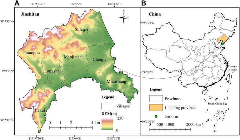
FIGURE 1. Study area location: (A) Jinshitan, (B) China.
2.2 Data sources
Jinshitan was officially identified as a national key scenic spot in 1988, which is the time when Jinshitan tourism began. Since this study used villages as the research scale, the requirements for data accuracy are relatively high, and the latest data we can obtain is 2019. Therefore, we selected four time points 1988, 1998, 2009, and 2019 from 1988 to 2019 to study the spatial reconstruction of Jinshitan settlements. The data used in this study include remote sensing images, land use, building, administrative division, socioeconomic and DEM data, as shown in Table 1.
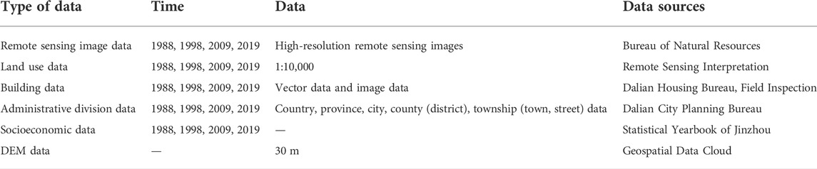
TABLE 1. Data sources and contents.
2.3 Research methods
In this study, a single land-use degree, comprehensive land-use degree, and land-use transition matrix were used to represent the spatial reconstruction of settlements. Building density, mean building height, and floor area ratio were used to represent the three-dimensional spatial reconstruction of settlements. Details are presented in Table 2.
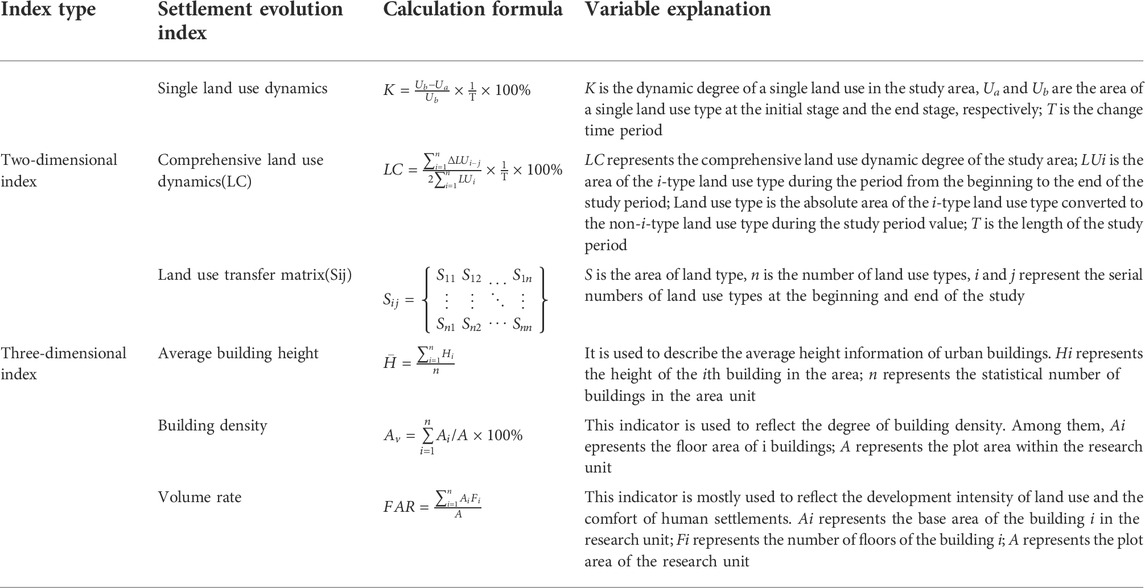
TABLE 2. Research method and descriptions.
3 Results
3.1 Two-dimensional spatial reconstruction of jinshitan settlement
By preprocessing the Jinshitan land use data, this study obtained the temporal and spatial patterns of land use types (Figure 2) and flow chart of cultivated land (Figure 3) in Jinshitan seven villages in 1988, 1998, 2009 and 2019.
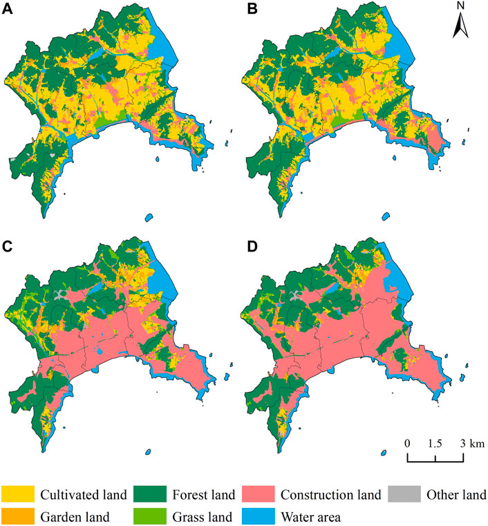
FIGURE 2. Land-use types in Jinshitan in (A) 1988, (B) 1998, (C) 2009, and (D) 2019.
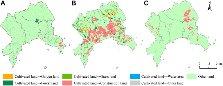
FIGURE 3. Flow chart of cultivated land in Jinshitan from (A) 1988–1998, (B) 1998–2009, and (C) 2009 2019.
In Figures 2, 3, from 1988 to 1998, the cultivated land in Jinshitan was converted to mainly construction land (Miaoshang Village) and woodland (Shizijie Village). From 1998 to 2009, the loss of cultivated land was the largest over 30 years. In 1998, the area of cultivated land was 18.400 km2. From 1998 to 2009, the area of Jinshitan transferred from cultivated land to construction land was 10.434 km2, which accounted for more than 50% of the total cultivated area. Figure 3 shows that the conversion of cultivated land from each village to forest land, garden land, and grassland was also evident. From the period of 1998–2009, the conversion of cultivated land to other land types was the largest to take place over the 30-years study period. In 2009, the loss of cultivated land was only 4.236 km2. From 2009 to 2019, cultivated land still got converted mainly to construction land; however, the conversion rate was much slower compared with that from 1998 to 2009.
According to the latest edition of the “Land Use Status Classification” (GBT21010-2017), combined with the Jinshitan area characteristics, land-use types were divided into seven categories, i.e., cultivated land, garden land, forest land, grassland, construction land, water area, water conservancy facility land, and other land. Tables 3, 4 shown that cultivated land in Jinshitan was greatly reduced, while construction land increased from 1988 to 2019; the transfer from cultivated land to construction land was as high as 82.288%. From the period of 1988–1998, there was not substantial change in the transfer of area between various types of land. Apart from an increase in cultivated land from 18.400 to 19.141 km2, the transfer of land types did not exceed 1 km2. From 1988 to 1998, construction land was scattered, with cultivated land scattered throughout it. From the period of 1998–2009, the area of land-use types in Jinshitan changed considerably, and 14.148 km2 of cultivated land was lost, of which the area transferred to construction land was up to 10.434 km2, and the areas transferred to grassland, woodland, and garden land were 1.347, 1.758, and 1.295 km2, respectively. In addition, most of the grasslands, woodlands, waters, and gardens were also converted to construction land, with transfer areas of 1.277, 2.248, 1.122, and 1.205 km2, respectively. Construction land was concentrated in Longshan, Manjiatan, and the southern part of Chenjia Village near the water area and exhibited compactness and dependencies. Transfers area between other land-use types did not exceed 1 km2. In 1988, 1998, 2009 and 2019, the land-use changes in coastal areas of Jinshitan were due to the reclamation movement and seawater erosion changes (Yan, et al., 2015).
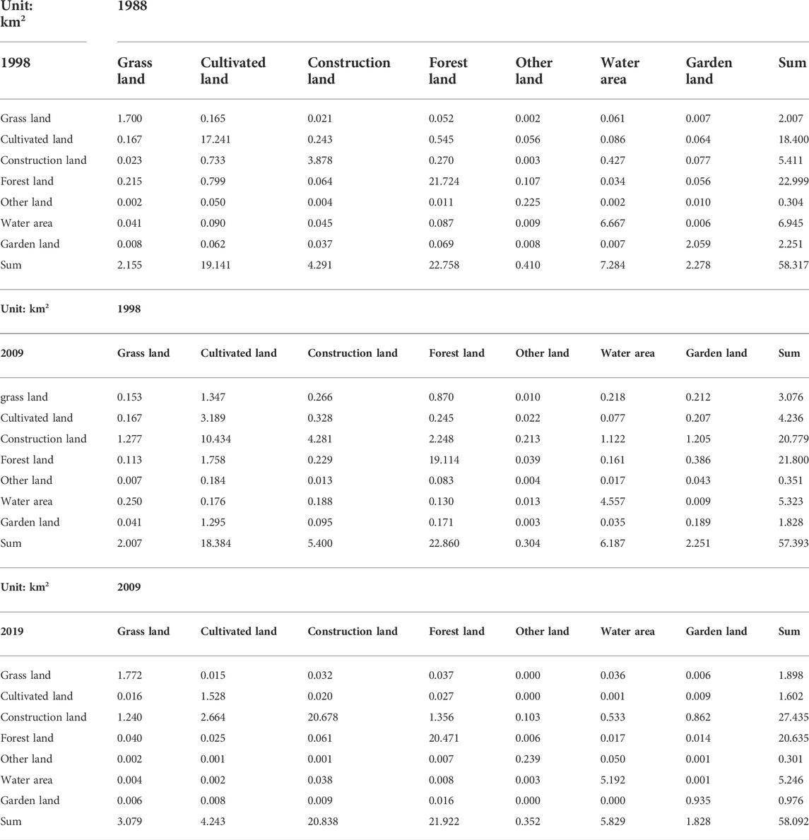
TABLE 3. Transfer matrix of land-use area in Jinshitan (1988–2019).
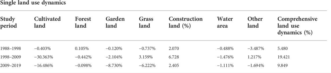
TABLE 4. Dynamic attitude of land use in Jinshitan (1988–2019).
3.2 Three-dimensional spatial reconstruction of jinshitan settlement
Reconstruction of the settlement space included the expansion of the horizontal space and had the characteristics of spatial heterogeneity in the vertical space. The road network was used to divide Jinshitan into patches of different shapes, and the three-dimensional spatial form of Jinshitan was described by three indicators: mean building height, building density, and floor area ratio, which increased continuously from the period of 1988–2009. The most rapid growth rate was observed on Wuyi Road in Jinshitan and in the southern part of the seaside. These three indicators were spatially presented with a high degree of consistency.
According to the “Planning and Design Standards for Urban Residential Areas” GB50180-2018, and the current land-use status in Jinshitan, the height of each floor is calculated as 3 m, and buildings are divided into five categories: one-story buildings (0–3 m), low-rise buildings (3–9 m), multistory buildings (9–18 m), small high-rise buildings (18–27 m), and high-rise buildings (27–36 m). As shown in Figure 4 (Mean Building Height), in 1988, all villages in Jinshitan were one-story buildings, i.e., bungalows. In the following 30 years, the mean overall building height in Jinshitan increased. In 1998, low-rise buildings appeared in seven villages and multistory buildings appeared in Manjiatan Villages. However, most buildings in Jinshitan were still bungalows in 1998. In 2009, small high-rise buildings appeared in Longshan and Manjiatan Villages, and most buildings were low-rise and multistory buildings. High-rise buildings appeared in Manjiatan Villages in 2019, at which time low-rise buildings also dominated, whereas only a small proportion of one-story buildings remained.
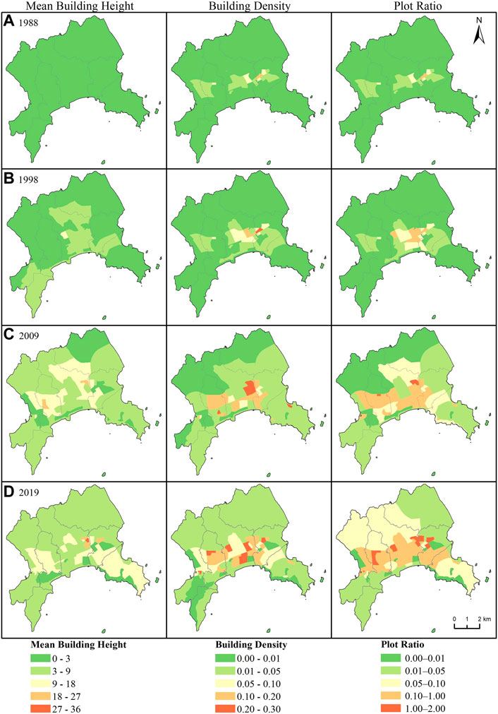
FIGURE 4. The three-dimensional spatial distribution of Jinshitan in (A) 1988, (B) 1998, (C) 2009, and (D) 2019. (Mean Building Height, Building Density and Plot Ratio)Figures.
Jinshitan has well-known scenic locations, such as the Gold Coast, Jinshi Cultural Expo Plaza, Binhai National Geopark, and Discovery Kingdom. As shown in Figure 4 (Building Density), because tourism resources occupy a certain land area, the overall building density of Jinshitan was still dominated by a low-density distribution throughout the study period. The overall building density exhibited an increasing trend from 1988 to 2019. At the end of the study, there was a more pronounced change in building density than at the beginning. The dense area was concentrated in the southern traffic line and coastline of Jinshitan from the period of 1988–2019. The greatest increase in building density in Jinshitan occurred from 1998 to 2009.
The floor area ratio can reflect the intensity of land-use development and comfort levels of residents in the living environment, and is the most commonly used indicator for measuring land-use intensity (Zhou, et al., 2021). As shown in Figure 4 (Plot Ratio), 1998–2009 was the period with the most rapid growth during the study period, and the villages with larger plot ratios included Longshan and Manjiatan village. Moreover, the plot ratio in the south increased more rapidly than that in the north. The plot ratio, mean building height, and building density showed high degrees of spatial consistency, which showed that construction land in Jinshitan exhibited a clear tendency to approach the road network and coastline. In future development planning of the region, attention should be paid to the balance between resource utilization of coastlines and road networks, and ecological environment protection.
3.3 Reconstruction of production space in jinshitan settlement
Jinshitan is a settlement with tourism as its leading industry. Therefore, the reconstruction of production space in Jinshitan mainly expounds the population type and revenue from 1988 to 2019 (Figure 5).
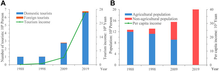
FIGURE 5. Population type and revenue in Jinshitan from 1988 to 2019 (A). Number of tourists and tourism revenue; (B). Population type and per capita income changes).
In 1988, the State Council officially approved Jinshitan as a key national scenic location and vigorous development of the tourism industry in Jinshitan officially commenced. In Figure 5A, the number of tourists increased rapidly from the period of 1988–2019; domestic tourists accounted for the vast majority, although the number of foreign tourists also increased, and the number of tourists also led to a continuous increase in tourism revenue. In 1989, a series of domestic and foreign factors brought a negatively impact to the tourism industry in Jinshitan. Jinshitan has slowly recovered since 1990, domestic tourists have accounted for 99% of the total number of tourists from1988 to 1998. Considerable financial expenditure was required during the period from1988 to 1998 on the construction of tourism infrastructure. Tourism revenue reached 59 million yuan in 1998. The period from 1998 to 2009 was the development period of Jinshitan tourism. Compared with the previous 10 years, tourists and tourism income increased steadily during this period; the total number of tourists increased by 2.74 times, the number of foreign tourists increased from 6,200 to 57,000, and tourism revenue was 620.34% that of the previous 10 years. The period of 2009–2019 was the “golden development period” of the tourism industry in Jinshitan. The configuration of tourism facilities and services was relatively complete and mature, and tourism had become a leading industry in the local area. Compared with 2009, the numbers of domestic and foreign tourists had increased by 3.8685 million and 96.2 thousand, respectively, by 2019, and tourism revenue also grew rapidly, increasing 7.22-fold from 2009 to 2019.
Figure 5B shown changes in population type and per capita income from 1988 to 2019. The booming tourism industry in Jinshitan has also driven the transformation of the local population and an increase in per capita income. During the research period, while the regional population increased steadily, the proportion of agricultural and non-agricultural populations also increased. By 2019, the non-agricultural population had reached 100%, exhibiting realization of the urbanization of villages and towns. In 1988, Jinshitan was dominated by rural areas, agriculture, and farming; the agricultural population accounted for 94.14% and the per capita income was only 1,275 yuan. From the period of 1998–2009, with the acceleration of tourism and urbanization, an increasing number of farmers joined the tourism service industry. The non-agricultural population increased from 1,842 in 1998 to 6,383 in 2009; from 1998 to 2009, the proportion of the non-agricultural population increased by 27.07% and the per capita income increased to 15,216 yuan. Jinshitan had achieved urbanization by 2019 because of regional resource endowment and sound development; the non-agricultural population had reached 100% and the per capita income had increased by 23,910.81 yuan. Changes in population type and per capita income were also highly consistent with the changes in land-use types.
3.4 Drivers of the spatial reconstruction of jinshitan settlement
Reconstruction of a settlement space is performed under the combined action of an endogenous pulling force and an exogenous pushing force (Van Hear, et al., 2018). Endogenous factors for spatial reconstruction, regional natural resources, traffic factors, climatic conditions, etc. are important basic conditions for the transformation and development of village and town settlement spaces. Based on the natural conditions of the region, the Chinese government and the market have adopted various policies to accelerate the economic development of the settlement space by means of external thrust. Social subjects are an additional endogenous pulling force for the reconstruction of regional space, which closely follows the pace of the government and the market throughout the reconstruction of space and plays a key role in the regional space reconstruction process. This study selected these four driving factors based on the previous research on settlement space reconstruction combined with the characteristics of this paper and the availability of data (Tao, et al., 2017; Dai, et al., 2021). Since this study used villages as the research scale, the data accuracy requirements are relatively high, which also causes certain difficulties in data acquisition. The data on the driving factors of the results were all obtained from the Statistical Yearbook of Jinzhou. After integration, analysis and screening, three time periods (budding stage, development stage, boom stage) were selected, and four driving factors natural conditions, government policies, market regulations and social subjects to explore its impact on the spatial reconstruction of tourist towns.
Figure 6 shown the drivers of the reconstruction of Jinshitan settlement space, which is divided into three stages: budding stage, development stage, and boom stage.
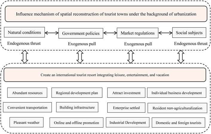
FIGURE 6. Drivers of the reconstruction of Jinshitan settlement space.
3.4.1 Budding stage (1988–1998)
3.4.1.1 Natural conditions
This period was the initial stage of the spatial reconstruction of Jinshitan. Jinshitan has a pleasant, temperate, continental climate which is warm in winter and cool in summer. It is bordered by the sea on three sides; the sea area is not frozen, and transportation is convenient. With the reputation as “Little Jiangnan in Northeast China,” Jinshitan is a valuable location for tourism and recreation. Before 1988, the promotion of Jinshitan tourism was in the preparatory stage. In 1988, Jinshitan was formally identified as a key national scenic location. The number of tourists and tourism revenue in1988 were also higher than those in previous years. However, in 1989, a series of domestic and foreign factors brought considerable difficulties to the tourism industry in Jinshitan (Committee, 1990). Jinshitan has since experienced a considerable increase in tourism.
3.4.1.2 Government policies
From the period of 1988–1998, the Chinese government adhered to the idea of developing, while the building industry has continuously carried out the basic engineering construction of Jinshitan by way of “supporting tourism by trade” and “supporting tourism by industry” (Committee, 1988), including roads, lawn greening, communication facilities, and entertainment facilities.
3.4.1.3 Market regulations
In 1988, the air navigation industry between Dalian and Jinshitan progressed smoothly, creating convenient traffic conditions for tourists. The Jinzhou Tourism Corporation and Zhuhai Special Economic Zone China Technology Development Corporation jointly operate the China International Yacht Club in 1991. This is the first marine yacht club in China at an international level, bringing athletes and domestic and foreign tourists to participate in yacht racing activities. It is of great significance to promote the development of tourism and accelerate the construction of modern international cities in Dalian.
3.4.1.4 Social subjects
The district actively carried out publicity work in such arenas as newspapers, magazines, and TV stations through advertisements, and exclusive interviews, and further expanded the popularity of Jinshitan by hosting activities such as summer camps, photography competitions, prose competitions, recording of scenery films. The improvement of the reputation of Jinshitan and tourism development have also successfully attracted a group of self-employed households, such as self-employed hotels, catering industries, and guesthouses, which has improved employment and reemployment of residents.
3.4.2 Development stage (1998–2009)
3.4.2.1 Natural conditions
In 2000, Jinshitan was rated as one of the first batch of national 4A-level tourist attractions in China. The period of 1998–2009 was the most critical period in Jinshitan for the reconstruction of the settlement space in the entire study area. Firstly, it was a period with the most rapid loss of cultivated land in land use space and of accelerated horizontal and vertical expansion of building space. It was also a period of considerable increases in population and income in the study area.
3.4.2.2 Government policies
In 2002, China’s first self-developed express train was implemented in Jinshitan. In the same year, a backbone a road network >80 km in length was constructed in the area, which further created favorable conditions for the tourism industry in Jinshitan and allowed citizens to enter Jinshitan. During the development stage, the government began to pay attention to environmental protection and regional coordinated sustainable development, intensified efforts to publicize environmental protection, implemented three major environmental improvement projects (greening, bright, and relocation projects), and planted numerous trees, shrubs, and green spaces in the area. Lighting was installed on both sides of the main road and adjacent to tall buildings, and the houses of relevant farmers, enterprises, and institutions in the relocation area were demolished.
3.4.2.3 Market regulations
The Jinshitan Theme Park Project was approved in 2002. The construction themes include amusement parks, commercial shopping areas, wharf areas for fishermen, villa areas, and hotel conference areas. This project has a variety of activities and facilities and a large scale, which has played a role in stimulating the economy in the area, as well as in forming a tourist resort area represented by golf clubs, hunting clubs, wax museums, and other international projects, attracting many domestic and foreign tourists, and gradually opening up the potential international market of Jinshitan.
3.4.2.4 Social subjects
Relying on the seasonal characteristics, four-season tourism activities are conducted in the area, including spring outings, seaside recreation in summer, scenic viewing in autumn, and snow viewing in winter. Furthermore, Dalian International Winter Swimming Festival, Liaoning Taijiquan Competition, Jinshi Carnival Parade, National Women’s Wushu Sanda Championships, and more than 30 other events have been successively organized and hosted, as well as big cherry garden parties, vineyard garden parties, farmhouse pleasures, visits from world celebrities, party and state leaders, etc. which have been hosted at the senior conference center. These projects attract considerable numbers of domestic and foreign tourists.
3.4.3 Boom stage (2009–2019)
3.4.3.1 Natural conditions
In 2010, Jinshitan became a national 5A-level scenic location. In 2015, it was rated a national eco-tourism demonstration area, and in 2019, it was awarded the title of China’s Tourism Influence Annual Cultural Scenic Spot. Compared with the previous 10 years, the tourists and tourism revenue had a clear increase. By 2019, the population structure of Jinshitan was 100% non-agricultural, and the urbanization of villages and towns was realized.
3.4.3.2 Government policies
Although the tourism industry in Jinshitan has entered a prosperous stage, the Chinese government has not relaxed its propaganda efforts, using the central location of the provincial capital Shenyang and important locations in Dalian City and Dalian District to conduct publicity advertisements and continuing to use the official WeChat and Weibo network platforms to simultaneously conduct online and offline marketing. Furthermore, the Chinese government regulates the tourism industry and conducts tourism service management, tourism market supervision, tourism safety management, tourism complaint handling, and tourism industry training.
3.4.3.3 Market regulations
In addition, to integrate regional culture and humanistic tourism in tourism projects, the Dalian Jinshi Tangfeng International Hot Spring Club, jointly built by the Dalian Jinma Group and Beijing Zhongsheng Group, was fully opened in 2010. The Dashang Jinshitan Commercial Center Plaza project, including business, residence, and shopping outlets, was officially opened in 2015. Project construction in the area steadily advanced with the construction of the Dalian Cultural Huaxia Museum, Dalian Jinshi International Winery, Tangjingze Hot Spring Town, Hot Spring Resort Hotel, Napa Valley Tourism Complex, and Botanical Garden. These projects resulted in realization of the integration of vacation, leisure, and tourism, and further improve the international and domestic popularity of Jinshitan.
3.4.3.4 Social subjects
The Tourism Bureau launched the “Dalian International Beach Culture Festival” which is conducted in Jinshitan every spring and summer, during which a series of activities such as a citizen sand sculpture competition, firework shows, beach music festivals, and summer carnival nights of the Kingdom of Discovery are held. In addition, the Jintang Hot Spring Health Culture Festival, Dalian International Winter Swimming Festival, and other activities have attracted millions of citizens as well as domestic and international tourists. During the boom stage, with the goal of improving tourist satisfaction, questionnaire surveys of tourists were conducted, tourist complaints and suggestions were appropriately handled, more attention was paid to the feelings of tourists, and problems expressed by tourists were managed humanely. The humanized management and attentive service of Jinshitan had left tourists with a good tourism experience.
4 Discussion
4.1 Reconstruction of jinshitan settlement space
Acceleration of urbanization and improvement of per capita income have promoted vigorous development of tourism in Jinshitan. An increasing number of scholars have begun to pay attention to the pattern evolution of tourism, its influencing factors, and the coordination relationship between tourism and the environment (Su, et al., 2020; Zhang, et al., 2020; Zhang and Li, 2020). However, the regularity of large-scale data (e.g., at national, provincial, and municipal levels) may not be universal to villages and towns. This study combined the perspectives of urbanization and tourism of villages and towns, using Jinshitan as the research area, which is a national 5A-level scenic location and is a considered a typical and representative study area.
In the process of tourism urbanization, optimization and adjustment of settlement space are important manifestations of the urbanization of villages and towns (Tao, et al., 2017). Due to the high data requirements in research on the town area, few previous studies have been based on small-scale spatial reconstruction of the town area, and the existing research on town-scale spatial reconstruction is based mostly on qualitative descriptions (Yang, et al., 2016; Hui, et al., 2020; Wang and Zhao, 2021). The research data in this study have high precision and were obtained from a wide array of sources, and the land-use data are accurate to 0.5 m. The data sources included official data, remote sensing interpretations, and field research. The time series of this study was 30 years.
Land, population, and industry are the three core elements of spatial reconstruction of villages and towns. The integration of land resources, non-agricultural transfer of the population, and driving development of industries both complement and restrict each other (Tu, et al., 2018; Zou, et al., 2021). This study divided Jinshitan into four time series from the beginning, development, and prosperity of tourism, from the dynamic changes of land use in two-dimensional horizontal space, to the evolution of architectural form in three-dimensional space, and to the reconstruction of the agricultural population and tourism resources in the production space. The spatial reconstruction of Jinshitan was quantitatively analyzed, and the drivers were qualitatively described to provide a reference for the development and protection of other small tourist villages and towns.
The drivers of Jinshitan spatial reconstruction is determined by the joint action of natural conditions, government policies, market regulations and social subjects. Through the development process of Jinshitan from 1988 to 2009, we can see that the settlement space of Jinshitan has undergone tremendous changes, and the town economy has also developed rapidly. Under such circumstances, Jinshitan should make policy formulations more cautiously and control the orientation of the market, not just pursuing high economic and rapid development, attention should also be paid to protecting and adapting to the development of natural resources. Environmental groups can be established or dynamic monitoring of natural resources can be strengthened. And we must pay attention to the development of the human environment, provide high-quality services for tourists, but also meet the needs of local residents.
4.2 Limitations
Trend statistics were adopted in this study to fill gaps, due to missing data for some years in the statistical yearbook. Although this did not have a considerable impact on the results during the study period, deviations from the true values will still have occurred. Due to the impact of the COVID-19 epidemic, the latest research data for Jinshitan in 2020 and 2021 could not be obtained. In the future, the spatial reconstruction, influencing factors, countermeasures, and reasonable suggestions of tourist towns under the COVID-19 epidemic, and other specific circumstances, can be further explored to provide a scientific basis for planning the development of characteristic towns.
5 Conclusion
Jinshitan has evolved from a small fishing village to a national 5A-level tourist attraction, and the changes that have occurred in the settlement space are typical of the reconstruction of the settlement space of tourist-oriented towns.
From the perspective of the two-dimensional spatial structure of Jinshitan settlements, during the entire study period, cultivated land in Jinshitan decreased by 16.798 km2, construction land increased by 22.024 km2, and the transfer of cultivated land to construction land was up to 82.288%. From the period of 1988–1998, the conversion between various land types in Jinshitan was not significant, but the transformation of area between different types of land use changed considerably from 1998 to 2009. From the period of 2009–2019, the conversion rate between various land types decreased considerably compared to that in 1998–2009.
From the perspective of the three-dimensional spatial structure of Jinshitan, the Jinshitan tourist town showed a high degree of consistency in terms of building density, mean building height, and floor area ratio, which have continued to increase over time. The buildings showed the characteristics of centralized distribution, all of which had the characteristics of moving towards the coast and the road network.
From the production space of Jinshitan, it is evident that both per capita income and tourism income have improved considerably. Domestic tourists were the main source of tourists in Jinshitan, and the number of foreign tourists has been gradually increasing. The population increased from 15.86% of the non-agricultural population at the beginning of the study to 100% at the end of the study, and the settlement space achieved complete urbanization of the population.
Jinshitan has a mild climate and an aesthetically pleasing environment. Since the establishment of tourism in Jinshitan, the Chinese government has been investing in construction, carrying out publicity advertisements, attracting investment, organizing activities, attracting millions of tourists annually, driving the development of self-employed households, and addressing local employment problems. The spatial reconstruction of Jinshitan settlement benefits from the rich natural resources in the region, government policy guidance, market orientation, and participation of social entities.
Data availability statement
The original contributions presented in the study are included in the article/Supplementary Material, further inquiries can be directed to the corresponding authors.
Ethics statement
Ethical review and approval was not required for the study on human participants in accordance with the local legislation and institutional requirements. Written informed consent from the participants was not required to participate in this study in accordance with the national legislation and the institutional requirements.
Author contributions
JY contributed to all aspects of this work, CS wrote the main manuscript text. L-EW, YL, YZ and JX conducted the experiment and analyzed the data. All authors reviewed the manuscript.
Funding
This research study was supported by the National Natural Science Foundation of China (grant no. 41771178, 42030409), the Fundamental Research Funds for the Central Universities (grant no. N2111003), Basic Scientific Research Project (Key Project) of the Education Department of Liaoning Province (Grant no. LJKZ0964, Natural Science Foundation of Guizhou Province (Grant no. [2019]1150), the Second Tibetan Plateau Scientific Expedition and Research Program (STEP) (Grant no. 2019QZKK1004).
Acknowledgments
The authors would like to acknowledge all colleagues and friends who have voluntarily reviewed the translation of the survey and the manuscript of this study.
Conflict of interest
The authors declare that the research was conducted in the absence of any commercial or financial relationships that could be construed as a potential conflict of interest.
Publisher’s note
All claims expressed in this article are solely those of the authors and do not necessarily represent those of their affiliated organizations, or those of the publisher, the editors and the reviewers. Any product that may be evaluated in this article, or claim that may be made by its manufacturer, is not guaranteed or endorsed by the publisher.
References
Bensimon, D., Weintraub, D., Lissak, M., and Azmon, Y. (1970). Moshava, kibbutz, and moshav. Patterns of Jewish rural settlement and development in Palestine. Rev. Francaise Sociol. 11 3, 438. doi:10.2307/3320627 |
Chai, Y., Qiao, W., Hu, Y., He, T., Jia, K., Feng, T., et al. (2021). Land-use transition of tourist villages in the metropolitan suburbs and its driving forces: A case study of she village in nanjing city, China. Land 10 2, 168. doi:10.3390/land10020168 |
Chan, K. W., and Wei, Y. (2019). Two systems in one country: The origin, functions, and mechanisms of the rural-urban dual system in China. EURASIAN Geogr. Econ. 422–454. doi:10.1080/15387216.2019.1669203 |
Dai, L., Fu, J., Rong, X., Li, D., and Yang, L. (2021). Transformation and reconstruction of rural area through tourism urbanization: A case study of simatai village, beijing. J. Chin. Archit. Urbanism 3 (1), 1–15. doi:10.36922/jcau.v3i1.1034 |
Gao, C., and Cheng, L. (2020). Tourism-driven rural spatial restructuring in the metropolitan fringe: An empirical observation. LAND USE POLICY 95, 104609. doi:10.1016/j.landusepol.2020.104609 |
Gladstone, D. L. (1998). Tourism urbanization in the United States. URBAN Aff. Rev. 34, 3–27. doi:10.1177/107808749803400101 |
Hall, R. B. (1931). Some rural settlement forms in Japan. Geogr. Rev. 21, 93–123. doi:10.2307/208949 |
Hoang, T. T. H., Van Rompaey, A., Meyfroidt, P., Govers, G., Vu, K. C., Nguyen, A. T., et al. (2020). Impact of tourism development on the local livelihoods and land cover change in the Northern Vietnamese highlands. Environ. Dev. Sustain. 22 2, 1371–1395. doi:10.1007/s10668-018-0253-5 |
Hui, T., Jing, G., and Kaiqiang, C. (2020). Space changes in the rural tourism area of mufu town, hubei province, China. J. Resour. Ecol. 11, 633–644. doi:10.5814/j.issn.1674-764x.2020.06.011 |
Islam, N., Sarkar, B., Basak, A., Das, P., Paul, I., Debnath, M., et al. (2022). A novel GIS-based MCDM approach to identify the potential eco-tourism sites in the Eastern Dooars region (Himalayan foothill) of West Bengal, India. Geocarto Int. 1, 31. doi:10.1080/10106049.2022.2076917 |
Jin, S., Yang, J., Wang, E., and Liu, J. (2020). The influence of high-speed rail on ice–snow tourism in northeastern China. Tour. Manag. 78, 104070. doi:10.1016/j.tourman.2019.104070 |
Juan, I. P., Pablo, J. C., and Juan, A. E. (2019). Does environmental sustainability contribute to tourism growth? An analysis at the country level. J. Clean. Prod. 213, 309–319. doi:10.1016/j.jclepro.2018.12.151 |
Kong, X., Liu, D., Tian, Y., and Liu, Y. (2019). Multi-objective spatial reconstruction of rural settlements considering intervillage social connections. J. Rural. Stud. 84, 254–264. doi:10.1016/j.jrurstud.2019.02.028 |
Li, Y., and Xi, J. (2019). Socio-spatial differentiation of tourist towns: A case study of huangshui town, chongqing. Chn. J. Urb. Environ. Stud. 6, 1850028. doi:10.1142/s2345748118500288 |
Li, Y., Liu, Y., Long, H., and Cui, W. (2014). Community-based rural residential land consolidation and allocation can help to revitalize hollowed villages in traditional agricultural areas of China: Evidence from Dancheng County, Henan Province. LAND USE POLICY 39, 188–198. doi:10.1016/j.landusepol.2014.02.016 |
Liu, H., Weng, D., and Liu, H. (2021). Decoding rural space reconstruction using an actor-network methodological approach: A case study from the yangtze river delta, China. Land 10 11, 1110. doi:10.3390/land10111110 |
Long, H., and Qu, Y. (2018). Land use transitions and land management: A mutual feedback perspective. LAND USE POLICY 74, 111–120. doi:10.1016/j.landusepol.2017.03.021 |
Ma, L., Liu, S., Niu, Y., and Chen, M. (2018). Village-scale livelihood change and the response of rural settlement land use: Sihe village of tongwei county in mid-gansu loess hilly region as an example. Int. J. Environ. Res. Public Health 15, 1801–3390. doi:10.3390/ijerph15091801 | |
Mai, T., and Smith, C. (2018). Scenario-based planning for tourism development using system dynamic modelling: A case study of cat Ba island, vietnam. Tour. Manag. 68, 336–354. doi:10.1016/j.tourman.2018.04.005 |
Ning, J., Liu, J., Kuang, W., Xu, X., Zhang, S., Yan, C., et al. (2018). Spatiotemporal patterns and characteristics of land-use change in China during 2010–2015. J. Geogr. Sci. 28 (5), 547–562. doi:10.1007/s11442-018-1490-0 |
Pallot, J. (1979). Rural settlement planning in the USSR. Sov. Stud. 31 2, 214–230. doi:10.1080/09668137908411238 |
Perdue, R. R., Long, P. T., and Allen, L. (1990). Resident support for tourism development. Ann. Tour. Res. 17, 586–599. doi:10.1016/0160-7383(90)90029-q |
Petrişor, A.-I., Hamma, W., Nguyen, H. D., Randazzo, G., Muzirafuti, A., Stan, M.-I., et al. (2020). Degradation of Coastlines under the Pressure of Urbanization and Tourism: Evidence on the Change of Land Systems from Europe, Asia and Africa. Land 9, 275. doi:10.3390/land9080275 |
Raza, S. A., Qureshi, M. A., Ahmed, M., Qaiser, S., Ali, R., and Ahmed, F. (2021). Non-linear relationship between tourism, economic growth, urbanization, and environmental degradation: Evidence from smooth transition models. Environ. Sci. Pollut. Res. 28 2, 1426–1344. doi:10.1007/s11356-020-10179-3 |
Su, M. M., Sun, Y., Wall, G., and Min, Q. (2020). Agricultural heritage conservation, tourism and community livelihood in the process of urbanization - xuanhua Grape Garden, Hebei Province, China. Asia Pac. J. Tour. Res. 25 (3), 205–222. doi:10.1080/10941665.2019.1688366 |
Tao, H., Huang, Z., and Ran, F. (2018). Rural tourism spatial reconstruction model from the perspective of atv: A case study of mufu township, hubei province, China. Sustainability 10 8, 2675–3390. doi:10.3390/su10082675 |
Tao, H., Liu, J., Deng, Y., and Du, A. (2017). Tourism sectorization opportunity spectrum model and space partition of tourism urbanization area: A case of the mayangxi ecotourism area, fujian province, China. J. Mt. Sci. 14 (3), 595–608. doi:10.1007/s11629-015-3747-8 |
Tu, S., Long, H., Zhang, Y., Ge, D., and Qu, Y. (2018). Rural restructuring at village level under rapid urbanization in metropolitan suburbs of China and its implications for innovations in land use policy. HABITAT Int. 77, 143–152. doi:10.1016/j.habitatint.2017.12.001 |
Van Hear, N., Bakewell, O., and Long, K. (2018). Push-pull plus: Reconsidering the drivers of migration. J. Ethn. Migr. Stud. 44 (6), 927–944. doi:10.1080/1369183x.2017.1384135 |
Wang, D., Jiang, D., Fu, J., Lin, G., and Zhang, J. (2020). Comprehensive assessment of production–living–ecological space based on the coupling coordination degree model. Sustainability 12 5, 2009. doi:10.3390/su12052009 |
Wang, F., and Zhao, X. (2021). A preliminary study on the guidance of spatial planning for tourist towns under the background of rural revitalization — taking sanjiang town as an example. Curr. Urban Stud. 597–608. doi:10.4236/cus.2021.93036 |
Wang, L., and Xiao, S. (2020). Tourism space reconstruction of a world heritage site based on actor network theory: A case study of the shibing karst of the south China karst world heritage site. Int. J. Geoheritage Parks 1016, 140–151. doi:10.1016/j.ijgeop.2020.05.005 |
Wang, R., and Guo, Q. (2018). Rural tourism spatial reconstruction research of tongxin rural historic district, sichuan province, China based on landscape architecture. dtssehs. 10, 2675. doi:10.12783/dtssehs/eiem2018/26954 |
Xu, X., Shi, S., and Huang, Q. (2014). The Chinese urban-rural dual fconomic structure model and analysis. Asian Agric. Res. 6 (1), 18–23.
Xi, J., Wang, X., Kong, Q., and Zhang, N. (2015). Spatial morphology evolution of rural settlements induced by tourism. J. Geogr. Sci. 25 (4), 497–511. doi:10.1007/s11442-015-1182-y |
Xi, J., Zhao, M., Ge, Q., and Kong, Q. (2014). Changes in land use of a village driven by over 25 years of tourism: The case of Gougezhuang village, China. LAND USE POLICY 40, 119–130. doi:10.1016/j.landusepol.2013.11.014 |
Xiang, Y., Meng, J., You, N., Chen, P., and Yang, H. (2019). Spatio-temporal analysis of anthropogenic disturbances on landscape pattern of tourist destinations: A case study in the Li river basin, China. Sci. Rep. 9, 19285. doi:10.1038/s41598-019-55532-w | |
Xie, J., Jin, X., Lin, Y., Cheng, Y., Yang, X., Bai, Q., et al. (2017). Quantitative estimation and spatial reconstruction of urban and rural construction land in Jiangsu Province, 1820–1985. J. Geogr. Sci. 27 (10), 1185–1208. doi:10.1007/s11442-017-1430-4 |
Yan, H., Wang, N., Yu, T., and Song, N. (2015). Hydrodynamic behavior and the effects of water pollution from dalian ’ s large-scale offshore Airport island in jinzhou bay, China. J. Waterw. Port. Coast. Ocean. Eng. 141, 5014003. doi:10.1061/(asce)ww.1943-5460.0000261 |
Yang, C., Huang, J., Lin, Z., Zhang, D., Zhu, Y., Xu, X., et al. (2018a). Evaluating the symbiosis status of tourist towns: The case of Guizhou Province, China. Ann. Tour. Res. 72, 109–125. doi:10.1016/j.annals.2018.07.008 |
Yang, J., Guo, A., Li, X., and Huang, T. (2018b). Study of the impact of a high-speed railway opening on China’s accessibility pattern and spatial equality. Sustainability 10 8, 2943–3390. doi:10.3390/su10082943 |
Yang, J., Guo, A., Li, Y., Zhang, Y., and Li, X. (2019). Simulation of landscape spatial layout evolution in rural-urban fringe areas: A case study of ganjingzi district. GIsci. Remote Sens. 56 (3), 388–405. doi:10.1080/15481603.2018.1533680 |
Yang, J., Yang, R., Chen, M., Su, C. J., Zhi, Y., and Xi, J. (2021a). Effects of rural revitalization on rural tourism. J. Hosp. Tour. Manag. 47, 35–45. doi:10.1016/j.jhtm.2021.02.008 |
Yang, R., Xu, Q., and Long, H. (2016). Spatial distribution characteristics and optimized reconstruction analysis of China’s rural settlements during the process of rapid urbanization. J. RURAL Stud. 47, 413–424. doi:10.1016/j.jrurstud.2016.05.013 |
Yang, X., and Pu, F. (2020). Spatial cognitive modeling of the site selection for traditional rural settlements: A case study of kengzi village, southern China. J. Urban Plan. Dev. 146, 4. doi:10.1061/(asce)up.1943-5444.0000616 |
Yang, Z., Yang, J., and Ren, K. (2021b). The analysis of the spatial production mechanism and the coupling coordination degree of the danwei compound based on the spatial ternary dialectics. Processes 9, 2281–3390. doi:10.3390/pr9122281 |
Yao, G., and Xie, H. (2016). Rural spatial restructuring in ecologically fragile mountainous areas of southern China: A case study of changgang town, jiangxi province. J. RURAL Stud. 1, 435–448. doi:10.1016/j.jrurstud.2016.07.014 |
Zekan, B., Weismayer, C., Gunter, U., Schuh, B., and Sedlacek, S. (2022). Regional sustainability and tourism carrying capacities. J. Clean. Prod. 339, 130624doi. doi:10.1016/j.jclepro.2022.130624 |
Zhang, C., Weng, S., and Bao, J. (2020). The changes in the geographical patterns of China’s tourism in 1978–2018: Characteristics and underlying factors. J. Geogr. Sci. 30 (3), 487–507. doi:10.1007/s11442-020-1739-2 |
Zhang, T., and Li, L. (2020). Research on temporal and spatial variations in the degree of coupling coordination of tourism–urbanization–ecological environment: A case study of heilongjiang. Environ. Dev. Sustain. 10, 8474–8491. doi:10.1007/s10668-020-00976-8 |
Zhao, X., Yi, P., Xia, J., He, W., and Gao, X. (2021). Temporal and spatial analysis of the ecosystem service values in the Three Gorges Reservoir area of China based on land use change. Environ. Sci. Pollut. Res. 1007, 26549–26563. doi:10.1007/s11356-021-17827-2 | |
Zhong, X. (2020). Research on rural cultural space reconstruction based on the theory of space production. E3S Web Conf. 189, 01001. doi:10.1051/e3sconf/202018901001 |
Zhou, D., Li, Z., Wang, S., Tian, Y., Zhang, Y., and Jiang, G. (2021). How does the newly urban residential built-up density differ across Chinese cities under rapid urban expansion? Evidence from residential FAR and statistical data from 2007 to 2016. LAND USE POLICY 104, 105365. doi:10.1016/j.landusepol.2021.105365 |
Zhu, S., Kong, X., and Jiang, P. (2020). Identification of the human-land relationship involved in the urbanization of rural settlements in Wuhan city circle, China. J. RURAL Stud. 77, 75–8310. doi:10.1016/j.jrurstud.2020.05.004 |
Keywords: tourism urbanization, spatial reconstruction, sustainable development, human-land relationship, jinshitan
Citation: Song C, Yang J, Wang L-e, Li Y, Zhi Y and Xia J( (2022) Spatiotemporal reconstruction and drivers of tourism-oriented towns: A case study of Jinshitan. Front. Environ. Sci. 10:1013908. doi: 10.3389/fenvs.2022.1013908
Received: 08 August 2022; Accepted: 29 August 2022;
Published: 16 September 2022.
Edited by:
Yuanyuan Guo, Tianjin University, ChinaCopyright © 2022 Song, Yang, Wang, Li, Zhi and Xia. This is an open-access article distributed under the terms of the Creative Commons Attribution License (CC BY). The use, distribution or reproduction in other forums is permitted, provided the original author(s) and the copyright owner(s) are credited and that the original publication in this journal is cited, in accordance with accepted academic practice. No use, distribution or reproduction is permitted which does not comply with these terms.
*Correspondence: Jun Yang, eWFuZ2p1bjhAbWFpbC5uZXUuZWR1LmNu; Ling-en Wang, d2FuZ2xlQGlnc25yci5hYy5jbg==; Yutong Li, ZGVhcmxpeXV0b25nQDE2My5jb20=