
94% of researchers rate our articles as excellent or good
Learn more about the work of our research integrity team to safeguard the quality of each article we publish.
Find out more
BRIEF RESEARCH REPORT article
Front. Environ. Sci., 26 November 2020
Sec. Land Use Dynamics
Volume 8 - 2020 | https://doi.org/10.3389/fenvs.2020.577406
This article is part of the Research TopicDesertification and RehabilitationView all 16 articles
An understanding of soil water content dynamics is important for vegetation restoration in an arid desert-oasis ecotone under different landscapes. In this study, the dynamics of soil water content under three typical landscapes (i.e., desert, sand-binding shrubland, and farmland shelter woodland) were investigated in the Hexi Corridor, northwest China, during the growing season from 2002 to 2013. The results showed that the soil water content in the deep layers decreased from 20–30% to a stable low level of 3–5% in the desert and shrubland. For the farmland shelter woodland, the soil water content at the deep layers also decreased, but the decrease rate was much smaller than the desert and shrubland. The decrease of soil water content in the deep soil layers among desert–shrubland–woodland was strongly associated with the increase of groundwater depths. The greatest increase of groundwater depths mainly occurred during 2008–2011, while the largest decrease of soil water content took place during the years 2009–2011, with a time-lag in response to increase in groundwater depths. This study provides new insight into the long-term dynamics of soil water content in a typical desert oasis ecotone under different landscape components from the influence of overexploiting groundwater that cannot be inferred from a short-term study. The findings demonstrate that the sharp increase of groundwater depths could be the main reason behind the reduction of soil water content in the clay interlayers, and sustainable development of groundwater resources exploitation is very important for the management of desert-oasis ecotone from a long-term perspective.
Soil water refers to the amount of water stored in the soil unsaturated zone and is often used as an indicator of water limitation in arid and semi-arid regions (Dobriyal et al., 2012). As an important component of the hydrological cycles, soil water is involved in many hydrological processes, such as soil infiltration from precipitation, the formation of runoff, discharge from groundwater, soil evaporation, and plant transpiration (Porporato et al., 2002; Kizito et al., 2012; Li et al., 2014). Soil water content is better expressed in terms of water availability to plants from an eco-hydrological perspective compared with rainfall or aridity index in dryland systems (Wang et al., 2012). A growing literature has demonstrated that the stability and availability of soil water in root zone is closely associated with the maintenance of arid ecosystem functions and services (Gao et al., 2015). Thus, monitoring soil water content is critical for comprehensively evaluating the benefits and consequences of vegetation restoration and ecosystem sustainable management in dryland ecosystems (Mohanty and Skaggs, 2001; Ruiz-Sinoga et al., 2011; Betti et al., 2016).
In arid northwest China, a defining geomorphologic feature is that many natural or artificial oases of different shapes and sizes are interspersed in widespread sandy deserts (Cheng et al., 1999). Desertification around the edge of these oases is a long-standing environmental problem and is expected to continue in the future due to human activities and climate change (Wang et al., 2015). This makes reestablishment of vegetation (i.e., shrub and tree plantations) a key strategy in ecosystem restorations and provision of ecosystem services in the translated zone between desert and oasis (i.e., desert-oasis ecotone) (Li and Shao, 2013a). However, the stability of artificial vegetation could be threatened by the deterioration of soil water and groundwater due to irrational agricultural irrigation (e.g., over exploitation of groundwater). Meanwhile, the dynamics of soil water content is also considered to differ significantly among components of a disturbed ecosystem (Li and Shao, 2013b). Thus, it is not an easy task to monitoring long-term dynamics of soil water content in a desert oasis ecotone with various soils, topography, vegetation, and land use types (Yi et al., 2014).
The Hexi Corridor is one of the main desert oasis regions in arid northwest China. Most of the oases are established naturally in the inland river deltas or on alluvial–diluvial plains (Zhang et al., 2003). Due to the rapid growing population and intensive demand for food, the conversion of shrubland or grassland to farmland is a recurrent problem in the oasis margins (Su et al., 2007). It has been reported that about 10% of shrubland or grassland previously used for pasture has been converted to cropland within the first half of the twentieth century. This conversion typically results in over exploitation of groundwater in the remaining marginal lands and increases groundwater level and shrinks groundwater resource. Understanding the spatial heterogeneity and variables of groundwater and estimating the dynamics of soil water content in different landscapes is crucial for various management and environmental protection in a desert oasis ecotone (Huang et al., 2012). Although many studies have been conducted to examine the temporal and spatial dynamics of soil water content of single landscape, e.g., the farmland (Ji et al., 2007), forest (Knight et al., 2002), and desert (Li et al., 2008), long-term monitoring of the dynamics of soil water content under different landscapes is urgently needed (Hu et al., 2011).
In this study, we considered the desert, shrubland, and woodland as an entire continuum system in the desert oasis ecotone to investigate the soil moisture dynamics, groundwater depths, vegetation conditions and their hydrological relations during the growing season from 2002 to 2013. The main objectives were to: (i) compare the dynamics of soil water content between distinct three landscapes and (ii) investigate the potential hydrological relations between groundwater and soil moisture across different landscapes.
The study area is located in a typical desert–oasis ecotone in Linze County of Gansu province in northwestern China (39° 21′ N, 100° 07′ E and altitude of 1,374 m). The area has a continental temperate desert climate: dry and hot in summer and cold in winter. The mean annual precipitation is only 117 mm. The potential annual evaporation is 2,390 mm, and the dryness index is 20.5. The annual rainfall has no significantly increasing or decreasing trend in the past 40 years (Supplementary Figure 1A). The mean annual temperature is 7.6°C, with the highest temperature at 39°C in July and lowest at −27°C in January, respectively. The annual mean and max temperature during the growing season also has no significantly increasing or decreasing trend in the last decade (Supplementary Figure 1B). The mean annual wind velocity is 3.2 ms−1, and the wind direction is mainly from the northwest. Gales with wind velocity above 17 m s−1 occur about 10–15 days year−1.
To curb wind erosion and alleviate its influence on the oasis, a succession of protection measures was implemented from desert to farmland, including fencing natural desert, conversing desert to shrubland and woodland at the edge of the oasis. After several decades, three distinctive landscapes (i.e., desert, sand-binding shrubland, and farmland shelter woodland) have gradually established along unprotected desert to farmland (Supplementary Figure 2).
To compare the temporal variation of soil moisture under different landscapes, three replicates of measurement sites for each landscape unit were selected in each landscape to minimize errors due to soil, topography, and vegetation heterogeneity (Supplementary Table 1). At the beginning of the soil sampling, the soil texture at the profile of 0–180 cm was determined by pipette method, and the soil is classified as different soil types based on international soil texture classification. The soil water content varied throughout the growing season (April–September), mostly through strong interactions with vegetation and groundwater, and basically remained constant over the winter, due to negligible root activity and human agricultural activity. And thus we considered the growing season to be the study period of interest here. At each site, a composite soil sample at different depths (20, 40, 60, 80, 100, 120, 140, 160, and 180 cm) was randomly collected from three sampling points by using a stainless steel auger (5 cm in diameter) on a sunny day on mid-April, May, June, July, August, and September during the growing season from years 2002 to 2013. Soil water content was then measured gravimetrically and calculated as the ratio of the mass of water to dry soil after drying the samples at 105°C.
Six groundwater depth monitoring wells were established along the desert, shrubland, and woodland at the edge of Linze Oasis (Supplementary Figure 1). The groundwater depths were recorded every 10 days from 2002 to 2011. The variation of soil water content was closely related to the local groundwater depths and the irrigation event. The farmland shelter woodland was irrigated once or twice from June to August with an irrigation amount of approximately 100 mm.
SPSSV15 and Origin 8 were used to estimate the soil moisture variation and trends of six observation sites. Mann-Kendall trend and linear regression analysis methods were performed to show the trend of soil moisture changes in different depths at different landscapes. According to the difference of soil water content, we divided the growing season into three different periods: early growing season (April–May), the middle growing season (June–August), and the late growing season (September–October). Soil water content anomalies during the different periods were used to assess soil moisture stress compared with normal conditions.
The vertical distribution of the soil water content could be mainly divided into two-layer types. For the interdune lowland, there was a slight difference between the soil water content of different depths in the upper soil layers, but the soil water content in the deeper layers (i.e., 80–180 cm) (Figures 1D–I) was much higher than that of the upper layers (i.e., 20, 40, and 60 cm) (Figures 1A–C). The soil water content was relatively stable in the upper layers, but the soil water content at deep layers decreased sharply from an initial 20–24 to 3–5% (Figures 1D–G), and the values of ß of Mann–Kendall analyses ranged from −0.11 to −0.18 (Table 1). For the leeward slope and dune top, the soil water content at different layers showed a similar pattern, and there was a slight difference among different depths.
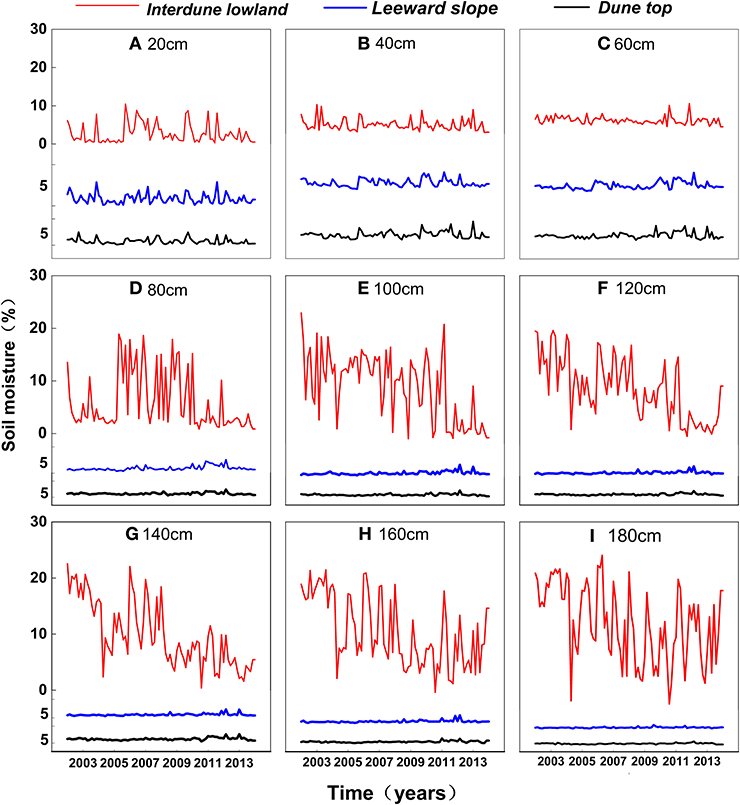
Figure 1. The dynamics of soil water content of different soil layers at (A) 20 cm, (B) 40 cm, (C) 60 cm, (D) 80 cm, (E) 100 cm, (F) 120 cm, (G) 140 cm, (H) 160 cm, and (I) 180 cm in desert.
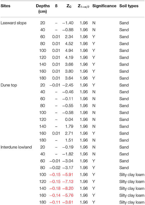
Table 1. Mann–Kendall test and field trends of soil water content in desert (red represents sharp decrease rate of soil water content).
In the shrubland of Elaeagnus angustifolia, there was also a slight difference between the soil water content of different depths in the upper soil layers, but the soil water content at deep layers of 160–180 cm decreased drastically from an initial 24 to 3%. The decline trend of the soil water content could be well-described by a linear function with a decrease rate of 0.1% every year (Figures 2H,I). Meanwhile, the values of ß of Mann-Kendall analyses ranged from m0.10 to −0.14 (Table 2). In the shrubland of Haloxylon ammodendron and Populus gansuensis, the soil water content at different depths was basically at a low level of 2–3%, except for the litter fall layers of Populus gansuensis (Figure 2).
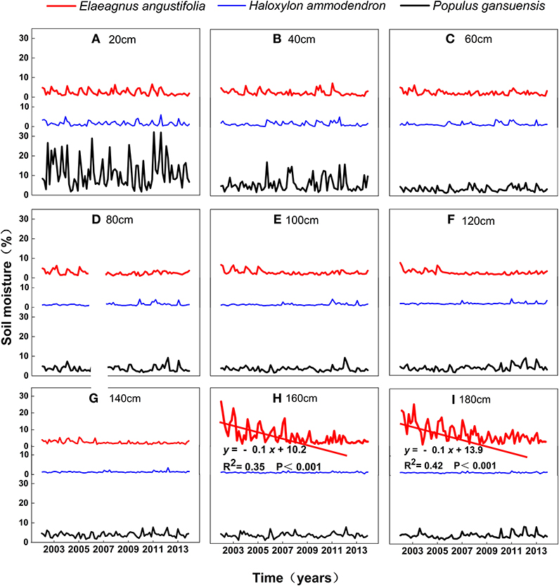
Figure 2. The dynamics of soil water content of different soil layers at (A) 20 cm, (B) 40 cm, (C) 60 cm, (D) 80 cm, (E) 100 cm, (F) 120 cm, (G) 140 cm, (H) 160 cm, and (I) 180 cm in shrubland.
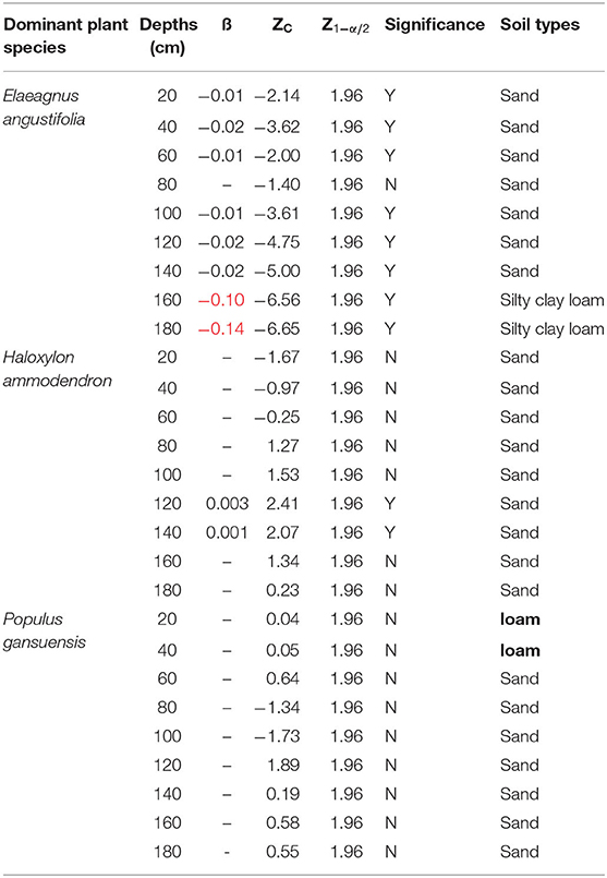
Table 2. Mann–Kendall test and field trends of soil water content in shrubland (red represents sharp decrease rate of soil water content).
In the farmland shelter woodland, the soil moisture of different depths of three sites show similar temporal trends and decreased uniformly and slightly at deep layers. The soil water content ranged between 4 and 12% at the surface layers (i.e., 20 cm), which was covered by litter falls (Figure 3). The soil water content at deeper layers decreased slightly and was basically kept stable (5–8%) (Figure 3; Table 3).
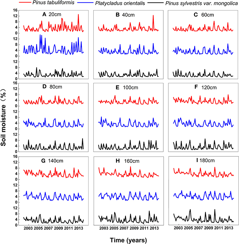
Figure 3. The dynamics of soil water content of different soil layers at (A) 20 cm, (B) 40 cm, (C) 60 cm, (D) 80 cm, (E) 100 cm, (F) 120 cm, (G) 140 cm, (H) 160 cm, and (I) 180 cm in woodland.
The anomalies of soil water content clearly varied over the growing season and exhibited strong seasonality in the interdune lowland. The higher values were mainly in early period and lower values were in middle and late period at the deep layers of 100–180 cm (Figure 4C1).
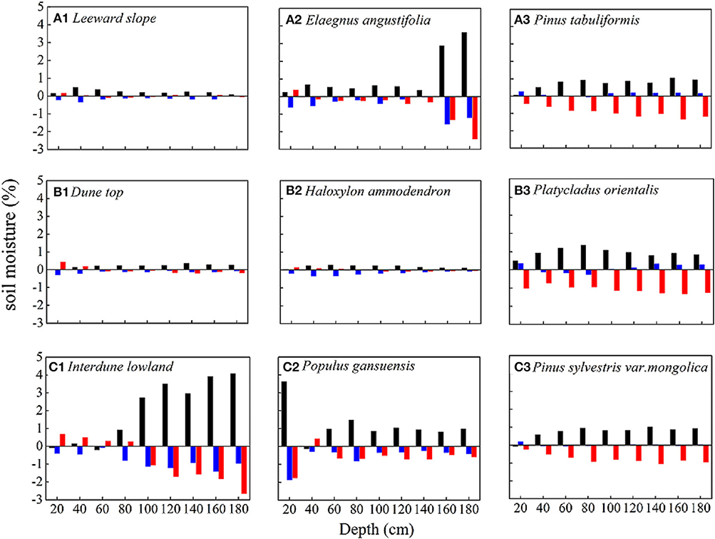
Figure 4. The anomalies of soil water content in desert (A1, B1, and C1), shrubland (A2, B2, and C2), and woodland (A3, B3, and C3). Black represents early period (April–May), blue represents middle period (June–August), and red represents late period (September–October).
In the shrubland of Elaeagnus angustifolia, the anomalies of soil water content exhibited similar pattern as desert lowland: the higher values were mainly in early period, but lower values were in middle and late period (Figure 4A2).
For farmland shelter woodland, the soil water content anomalies of the three sites exhibited similar patterns: higher values are observed in early and middle period, but lower values in late period (Figures 4A3–C3).
In this study, the differences of soil water content under the three landscapes were compared at several soil layers. Increased variability with soil depth was observed at the desert and shrubland. We found that distinct silty clay layers existed in the deep soil profiles of desert and shrubland. The soil water content in these clay interlayers was more variable than upper soil layers (i.e., sand layers). Consistent with our study, Sun et al. (2018) also found that clay layers existed at the same study site. Qi et al. (2003) and Gong et al. (2005) also reported that alluvial alluvium or the loess-like parent material was the main soil-forming parent material in the inland river basin of Heihe. Compared with sand layers, these silty clay layers have much stronger water-holding capacity but greater variations (Miller and Franklin, 2002; Su et al., 2004; Betti et al., 2016). In this study, we found that the clay layers could hold more water compared with sand layers, but the soil water content decreased sharply after the year 2009. In desert, the soil water content of sand layers would not change too much due to its limited soil water-holding capacity. This result seemed to support the findings from other similar studies. For instance, Mohanty and Skaggs (2001) reported that the soil water content of sandy loam was more stablethan silty loam in 0–5 cm. Hu et al. (2010) also found that the temporal stability of sandy soils was significantly stronger than that of the sandy loam and silt loam. The inverse texture effects suggest that “taller and denser perennial vegetation” could mainly occur on coarse-textured soils but not fine-textured soils at arid regions with limited precipitation and high evaporation (Noy-Meir, 1973; Sperry and Hacke, 2002). This may be attributed to the soil desiccation at the silty clay layers and its negative effects of preventing root penetration into deeper layers (Li et al., 2013). As such, we predicted that in our study environmental degradation (i.e., significant reduction of soil water content) may lead to a sharp reduction in the biomass and diversity of deep-rooted plants in arid desert ecosystems.
In arid desert ecosystems, the soil water can be replenished by infiltration from rainfall and recharge from groundwater, and the soil water is mainly lost from the soil by evaporation and transpiration of different vegetation types. These inputs and outputs resulted in the changes of soil water content. Surface water in the oasis is very limited and restricted due to rapid population growth, social-economic development, and large-scale expansion of farmland in the recent decades (Liu et al., 2010). Agricultural production therefore heavily relies on groundwater irrigation, and the groundwater irrigation area increased nearly 10 times from 2002 to 2011 in this study area (Wang and Zhao, 2015; Wang et al., 2015).
In this study, we found that the soil water content in the woodland decreased slightly and was apparently more stable than that in the desert and shrubland. Obviously, this was caused by the irrigation in the woodland, which could enhance the soil water content in the different soil layers. In contrary to woodland, the soil water content decreased sharply in the interdune lowland with clay interlayers during the years 2008–2010. The decrease of soil water content may be attributed to the increase of groundwater depths, which restricts groundwater access to deep soil layers via capillary transport (Supplementary Figure 3). In the natural desert, the groundwater depths ranged from 2 to 5 m, and as the depths of groundwater increased, groundwater could not be transported to plant roots through capillary actions. In the shrubland, we also found that the soil water content in 160–180 cm decreased continually with time. Three major mechanisms may account for the decrease in soil moisture. First, large-area re-vegetation of big shrubs and trees caused high evapotranspiration amount (Chang et al., 2006). Second, the annual precipitation amount is only 110 mm, and the dominant rainfall types are small rainfall events (<5 mm) which can only wet the top soil (0–60 cm) and normally evaporate back quickly after rainfall (Shen et al., 2014; Wang et al., 2019). Furthermore, intensive abstraction of groundwater for farmland irrigation may lead to the increase of groundwater depths, and less groundwater can recharge the soil water content at deep layers.
The low soil water content anomalies at different landscapes were observed mainly around the middle and late period, which coincides well with the increased in groundwater depths (Supplementary Figure 4). These results suggest that the groundwater depths have an influence on soil water content at 160–180 cm. The desert-oasis ecotone is a groundwater-dependent system, where groundwater controls the soil water content at deep depths, which directly affects the dynamic of soil water content and vegetation at different temporal and spatial scales (Huang et al., 2012). Normally, the soil water content is much higher under shallower groundwater depths than deeper ones. This may be caused by the effects of capillary actions. In this study area, due to the intensive expanding farmland at the edge of oasis, agricultural irrigation have consumed too much groundwater, and the groundwater depths significantly increased (Supplementary Figure 3). When groundwater depths are higher than the capillary rise height, groundwater could not support soil water content at deep soil layers. The intensive expanding of farmland, strong competition between agricultural and ecological water, intensive pumping of groundwater, and sharp decrease in soil water content have made good water management more important than ever before.
This study examined the dynamics of soil water content of three different landscapes in a typical desert-oasis ecotone of northwestern China. For desert and sand-fixing shrubland, the soil water content at deeper clay layers decreased sharply due to increased groundwater depths and intensive shrub plantation. For the farmland shelter woodland, the soil water content was relatively stable except for the deep soil layers. The soil water content at deep depths also decreased, but the decrease rate was much smaller than the desert and shrubland due to irrigation. The increase of groundwater depths is the major reason for the decrease of soil water content of desert and shrubland, so a balance between ecological and agricultural water requirement should be considered based on the groundwater storage in the desert-oasis ecotones.
The raw data supporting the conclusions of this article will be made available by the authors, without undue reservation.
GW wrote the manuscript and designed the experiment. QG performed manuscript review. YH, HZ, and XZ provided assistance for data analysis. All authors contributed to the article and approved the submitted version.
This research was funded by Opening Foundation of Key Laboratory of Desert and Desertification, Chinese Academy of Sciences (Grant No. KLDD-2020-05), the National Natural Science Foundation of China (Grant No. 41701045), and Shanxi Provincial Natural Science Foundation of China (Grant No. 201801D221336).
The authors declare that the research was conducted in the absence of any commercial or financial relationships that could be construed as a potential conflict of interest.
We thank John B. Bradford and Dr. Baoli Liu for giving us so many good suggestions for this study. We also appreciate the guidance of Professor Wenzhi Zhao.
The Supplementary Material for this article can be found online at: https://www.frontiersin.org/articles/10.3389/fenvs.2020.577406/full#supplementary-material
Betti, G., Grant, C. D., Murray, R. S., and Churchman, G. J. (2016). Size of subsoil clods affects soil-water availability in sand-clay mixtures. Soil Res. 54, 276–290. doi: 10.1071/SR15115
Chang, X. X., Zhao, W. Z., Zhang, Z. H., and Su, Y. Z. (2006). Sap flow and tree conductance of shelter-belt in arid region of China. Agric. For. Meteorol. 138, 132–141. doi: 10.1016/j.agrformet.2006.04.003
Cheng, G. D., Xiao, D. N., and Wang, G. X. (1999). On the characteristics and building of landscape ecology in arid area. Adv. Geosci. 14, 11–15.
Dobriyal, P., Qureshi, A., Badola, R., and Hussain, S. A. (2012). A review of the methods available for estimating soil moisture and its implications for water resource management. J. Hydrol. 458–459, 110–117. doi: 10.1016/j.jhydrol.2012.06.021
Gao, X., Zhao, X., Si, B. C., Brocca, L., Hu, W., and Wu, P. (2015). Catchment-scale variability of absolute versus temporal anomaly soil moisture: time-invariant part not always plays the leading role. J. Hydrol. 529, 1669–1678. doi: 10.1016/j.jhydrol.2015.08.020
Gong, Z., Ganlin, Z., Jizhi, W., Leide, Z., Dagang, Y., Xinling, R., et al. (2005). Formation and taxonomy of irrigation—silted soils in China. Arid Zone Res. 22, 4–10.
Hu, W., Shao, M. A., Han, F., Reichardt, K., and Tan, J. (2010). Watershed scale temporal stability of soil water content. Geoderma 158, 181–198. doi: 10.1016/j.geoderma.2010.04.030
Hu, W., Shao, M. A., Han, F. P., and Reichardt, K. (2011). Spatio-temporal variability behavior of land surface soil water content in shrub- and grass-land. Geoderma 162, 260–272. doi: 10.1016/j.geoderma.2011.02.008
Huang, Y. L., Chen, L. D., Fu, B. J., Huang, Z. L., Gong, J., and Lu, X. X. (2012). Effect of land use and topography on spatial variability of soil moisture in a gully catchment of the loess Plateau, China. Ecohydrology 5, 826–833. doi: 10.1002/eco.273
Ji, X. B., Kang, E. S., Chen, R. S., Zhao, W. Z., Zhang, Z. H., and Jin, B. W. (2007). A mathematical model for simulating water balances in cropped sandy soil with conventional flood irrigation applied. Agric. Water Manag. 87, 337–346. doi: 10.1016/j.agwat.2006.08.011
Kizito, F., Dragila, M. I., Senè, M., Brooks, J. R., Meinzer, F. C., Diedhiou, I., et al. (2012). Hydraulic redistribution by two semi-arid shrub species: implications for Sahelian agro-ecosystems. J. Arid Environ. 83, 69–77. doi: 10.1016/j.jaridenv.2012.03.010
Knight, A., Blott, K., Portelli, M., and Hignett, C. (2002). Use of tree and shrub belts to control leakage in three dryland cropping environments. Aust. J. Agric. Res. 53, 571–586. doi: 10.1071/AR01089
Li, D., and Shao, M. (2013a). One-dimensional Markov chain simulation of vertical change of soil texture in middle reaches of Heihe River, northwest China. Trans. Chin. Soc. Agric. Eng. 29, 71–80. doi: 10.3969/j.issn.1002-6819.2013.05.010
Li, D., and Shao, M. (2013b). Simulating the vertical transition of soil textural layers in north-western China with a Markov chain model. Soil Res. 51, 182–192. doi: 10.1071/SR12332
Li, X. R., He, M. Z., and Jia, R. L. (2008). The response of desert plant species diversity to the changes in soil water content in the Middle-1ower reaches of the Heihe River. Adv. Earth Sci. 23, 685–691.
Li, X. R., Zhang, Z. S., Huang, L., and Wang, X. P. (2013). Review of the ecohydrological processes and feedback mechanisms controlling sand-binding vegetation systems in sandy desert regions of China. Chin. Sci. Bull. 58, 1483–1496. doi: 10.1007/s11434-012-5662-5
Li, X. R., Zhang, Z. S., Tan, H. J., Gao, Y. H., Liu, L. C., and Wang, X. P. (2014). Ecological restoration and recovery in the wind-blown sand hazard areas of northern China: relationship between soil water and carrying capacity for vegetation in the tengger desert. Sci. China 57, 539–548. doi: 10.1007/s11427-014-4633-2
Liu, B., Zhao, W. Z., Chang, X. X., Li, S. B., Zhang, Z. H., and Du, M. W. (2010). Water requirements and stability of oasis ecosystem in arid region, China. Environ. Earth Sci. 59, 1235–1244. doi: 10.1007/s12665-009-0112-7
Miller, J., and Franklin, J. (2002). Modeling the distribution of four vegetation alliances using generalized linear models and classification trees with spatial dependence. Ecol. Modell. 157, 227–247. doi: 10.1016/S0304-3800(02)00196-5
Mohanty, B. P., and Skaggs, T. H. (2001). Spatio-temporal evolution and time-stable characteristics of soil moisture within remote sensing footprints with varying soil, slope, and vegetation. Adv. Water Resour. 24, 1051–1067. doi: 10.1016/S0309-1708(01)00034-3
Noy-Meir, I. (1973). Desert ecosystems: environment and producers. Annu. Rev. Ecol. Syst. 4, 25–51. doi: 10.1146/annurev.es.04.110173.000325
Porporato, A., D'odorico, P., Laio, F., Ridolfi, L., and Rodriguez-Iturbe, I. (2002). Ecohydrology of water-controlled ecosystems. Adv. Water Resour. 25, 1335–1348. doi: 10.1016/S0309-1708(02)00058-1
Qi, S., Honglang, X., and Fuxing, L. (2003). Productive potential of soil resources of linze in the heihe corridor. J. Desert Res. 23, 182–186.
Ruiz-Sinoga, J. D., Gabarrón Galeote, M. A., Martinez Murillo, J. F., and Marin, R. G. (2011). Vegetation strategies for soil water consumption along a pluviometric gradient in southern Spain. Catena 84, 12–20. doi: 10.1016/j.catena.2010.08.011
Shen, Q., Gao, G., Fu, B., and Lü, Y. (2014). Soil water content variations and hydrological relations of the cropland-treebelt-desert land use pattern in an oasis-desert ecotone of the Heihe River Basin, China. Catena 123, 52–61. doi: 10.1016/j.catena.2014.07.002
Sperry, J. S., and Hacke, U. G. (2002). Desert shrub water relations with respect to soil characteristics and plant functional type. Funct. Ecol. 16, 367–378. doi: 10.1046/j.1365-2435.2002.00628.x
Su, Y. Z., Zhao, H. L., Zhao, W. Z., and Zhang, T. H. (2004). Fractal features of soil particle size distribution and the implication for indicating desertification. Geoderma 122, 43–49. doi: 10.1016/j.geoderma.2003.12.003
Su, Y. Z., Zhao, W. Z., Su, P. X., Zhang, Z. H., Wang, T., and Ram, R. (2007). Ecological effects of desertification control and desertified land reclamation in an oasis-desert ecotone in an arid region: a case study in Hexi Corridor, northwest China. Ecol. Eng. 29, 117-124. doi: 10.1016/j.ecoleng.2005.10.015
Sun, C. P., Zhao, W. Z., and Yang, Q. Y. (2018). Water retention of the clay interlayer of dunes at the edge of an oasis. Acta Ecol. Sinica 38, 3879–3888. doi: 10.5846/stxb201705250970
Wang, G. H., Gou, Q. Q., and Zhao, W. Z. (2019). Effects of small rainfall events on Haloxylon ammodendron seedling establishment in Northwest China. Curr. Sci. 116, 121–127. doi: 10.18520/cs/v116/i1/121-127
Wang, G. H., and Zhao, W. Z. (2015). The spatiotemporal variability of groundwater depth in a typical desert-oasis ecotone. J. Earth Syst. Sci. 124, 799–806. doi: 10.1007/s12040-015-0571-z
Wang, S., Fu, B. J., Gao, G. Y., Yao, X. L., and Zhou, J. (2012). Soil moisture and evapotranspiration of different land cover types in the Loess Plateau, China. Hydrol. Earth Syst. Sci. 16, 2883–2892. doi: 10.5194/hess-16-2883-2012
Wang, T., Xue, X., Zhou, L., and Guo, J. (2015). Combating aeolian desertification in Northern China. Land Degr. Dev. 26, 118–132. doi: 10.1002/ldr.2190
Yi, J., Zhao, Y., Shao, M., Zhang, J., Cui, L., and Si, B. (2014). Soil freezing and thawing processes affected by the different landscapes in the middle reaches of Heihe River Basin, Gansu, China. J. Hydrol. 519, 1328–1338. doi: 10.1016/j.jhydrol.2014.08.042
Keywords: desert-oasis ecotone, vegetation restoration system, soil desiccation, clay inter-layers, textural profile
Citation: Wang G, Gou Q, Hao Y, Zhao H and Zhang X (2020) Dynamics of Soil Water Content Across Different Landscapes in a Typical Desert-Oasis Ecotone. Front. Environ. Sci. 8:577406. doi: 10.3389/fenvs.2020.577406
Received: 29 June 2020; Accepted: 20 October 2020;
Published: 26 November 2020.
Edited by:
Xian Xue, Northwest Institute of Eco-Environment and Resources (CAS), ChinaReviewed by:
Xinping Wang, Cold and Arid Regions Environmental and Engineering Research Institute (CAS), ChinaCopyright © 2020 Wang, Gou, Hao, Zhao and Zhang. This is an open-access article distributed under the terms of the Creative Commons Attribution License (CC BY). The use, distribution or reproduction in other forums is permitted, provided the original author(s) and the copyright owner(s) are credited and that the original publication in this journal is cited, in accordance with accepted academic practice. No use, distribution or reproduction is permitted which does not comply with these terms.
*Correspondence: Guohua Wang, Z2ltaTEyM0AxMjYuY29t
Disclaimer: All claims expressed in this article are solely those of the authors and do not necessarily represent those of their affiliated organizations, or those of the publisher, the editors and the reviewers. Any product that may be evaluated in this article or claim that may be made by its manufacturer is not guaranteed or endorsed by the publisher.
Research integrity at Frontiers

Learn more about the work of our research integrity team to safeguard the quality of each article we publish.