 Rafael Falci Ercoli
 Valéria Cristina Palmeira Zago
- Federal Center for Technological Education of Minas Gerais, Belo Horizonte, Brazil
The growth of the real estate market is considered one of the leading economic indicators of city development. The pressure for new sites for the construction of buildings and houses causes significant and severe socio-environmental impacts. The municipality of Nova Lima is conurbated with Belo Horizonte, the capital of Minas Gerais State, Brazil. In recent decades, the municipality of Nova Lima has been attracting real estate developers of luxury housing because of its favored location in a valley surrounded by mountain ranges with stunning landscapes. This study aimed to evaluate the emergence and evolution of erosive processes in a region of high real estate pressure in the municipality of Nova Lima, Minas Gerais State, Brazil. The study site is considered an area of environmental protection, belonging to the “Cardoso” river basin, a tributary of the “das Velhas” river. The images of the area were obtained by an “unmanned aerial vehicle,” with flights performed in 2019. Orthomosaic, digital surface and elevation models were obtained from these images. Historical series of satellite imagery provided by Google Earth were also used, as well as a survey of secondary data on the use and soil occupation of the region. The intense expansion of the real estate sector in metropolitan areas put pressure on environmental preservation in peri-urban areas. In this study, erosion processes and gullies were observed as a result of the construction of luxury residences. Construction residues of the buildings were disposed on the floor of a valley, burying the source of the “Estrangulado” Stream. The appearance of gullies is attributed to a combination of factors such as the removal of vegetation cover, the irregular disposal of construction waste in an environmental protection area, an insufficient drainage system for rainwater, and the lack of water collection and treatment of domestic wastewater. Over the years, the dimensions of gullies have increased and can cause damage to the buildings there. Also, the soil and sediment washed away by the runoff will affect the volume and quality of water in a watershed that is essential for supplying the metropolitan region of Belo Horizonte, Minas Gerais, Brazil.
Introduction
Anthropic influence is typically the main factor behind the formation of gullies, which reflects the history of countries, in the way they use and occupy land (Castillo and Gómez, 2016). Cities are becoming driving forces in environmental trends as most of the global population resides in urban areas due to the increased intensity of activities that is brought to cities (Marcotullio et al., 2008).
Urban sprawl is global phenomena. Worldwide, 54.9% of the human population lives in urban areas and by 2050 it will reach 66% (EUROSTAT, 2016). In 2010, the total land area of the world’s urban settlements covered approximately one million square kilometers, and, by 2050, urban land area is expected to increase to more than three million square kilometers (Angel et al., 2016). In Brazil, this phenomenon is still the most intense, since the urban population is already 84% of the total population (Instituto Brasileiro de Geografia e Estátistica [IBGE], 2015).
Accelerated soil erosion could even become more severe in urban areas with high population growth and high rainfall intensity. Soil erosion has assumed destructive dimensions in many parts of the world, especially in the urban environment (Adediji and Ibitoye, 2013; Rotta and Zuquette, 2014; Guerra et al., 2018; Zolezzi et al., 2018). In tropical regions, water erosion is prevalent. It occurs from a sum of factors, such as erosivity (intensity and frequency of rainfall), soil erodibility (intrinsic characteristics of the soil), relief and land use. Intensity and rain velocity are related to particle detachment and transport through runoff (Carvalho et al., 2006). Erosive processes have more drastic effects on steeper slopes without vegetation cover and with low permeability. As runoff drags particles from the soil, it leads to the appearance of furrows, which may develop into ravines and gullies. Gullies represent the most severe form of erosion, originating from the gradual development of the ravine process, which can reach the water table (Bertoni and Lombardi Neto, 2012).
Although the physical processes leading to the beginning and development of ravines are similar in urban and rural areas, the development of urban gullies is prone to occur in uncovered soil, closely related to construction activities, road development, and inadequate planning of urban drainage systems (Ferreira et al., 2018).
From an economic standpoint, erosion destroys the urban infrastructure and from an environmental point of view, erosion causes siltation of lakes and canals. In addition to the environmental problems, there are also health issues, since areas excavated by erosion in urban regions tend to become the focus of pathogenic vectors due to the accumulation of waste and sewage (Coulon et al., 2016; Yao, 2018; Ferreira et al., 2018).
The process of urbanization has been increasing due to the demand for more housing and other socio-economic activities. The processes of land use and occupation in the municipality of Nova Lima, Minas Gerais State, Brazil, is expressed by mining activities, land parceling, urban expansion, industrial and commercial activities at different scales. Thus, there was a change in the socio-spatial dynamics and pressure on environmental protection areas in the southern of the Belo Horizonte Metropolitan Region (Curi, 2019). Much of the urban terrain has been altered either directly in the form of buildings encroaching upon the upper slope, or indirectly by re-routing runoff water into them (Adediji et al., 2013). Other activities, such as the use of heavy machinery during building and road constructions, further help to compact soil of the immediate environment (Hu and Bai, 2007).
Drone-based 2D and 3D digital models may be used to quantify gully and bare land erosion in a large area (Xu et al., 2019; Yang et al., 2019). Drone-based products could save time, money, and achieve real-time monitoring. Although it might need to consider atmospheric impacts such as temperature and humidity when capturing images, it has no time and space restrictions compared to surveying directly in the field (Awange and Kiema, 2018; Gudino-Elizondo et al., 2018). Within this context, this work aimed to evaluate the emergence and evolution of erosive processes in a region with high real estate pressure in the municipality of Nova Lima, Minas Gerais State, Brazil.
Materials and Methods
Study Area Location
The municipality of Nova Lima has a total area of 427.7 km2 and an estimated population of 94,899 people (Instituto Brasileiro de Geografia e Estátistica [IBGE], 2019). It is located in the Metallurgical Zone of Minas Gerais, in the “Quadrilátero Ferrífero” region (QF), conurbated to the south with the state capital of Minas Gerais, Belo Horizonte. According to the Ecological-Economic Zoning (EEZ), it belongs to the Southern Environmental Protection Area (Companhia de Pesquisa de Recursos Minerais [CPRM], 2005). These areas represent fragments of the original vegetation of the region.
Hydrologically, Nova Lima is part of the “São Francisco” river basin and of the “das Velhas” river subbasin. Its tributaries on the left bank are the “Peixe,” “Macacos,” “Cristais,” and “Cardoso” streams. In the “das Velhas” river sub-basin are located the primary water supply points, responsible for approximately 50% of the water supply of the Belo Horizonte Metropolitan Region (RMBH) (Nova Lima, 2015). The prevailing climate in the basin is the semi-humid tropical, with humid and moderately hot summers, dry, and mild winters (Cherem, 2008).
The study area is located within the northern portion of the municipality of Nova Lima, at the foot of “Curral” Ridge, in a region conurbated to the municipality of Belo Horizonte. Its geographic coordinates are 19°58′28.45′′S and 43°55′39.83′′N. It is part of the “Vila da Serra” Special Guidelines Area, created by the Municipal Law number 2007 of August 28, 2007. It partially occupies the headwaters of the “Estrangulado” stream, belonging to the “Cardoso” stream sub-basin. The “Estrangulado” stream sub-basin has an area of 8.5 km2, corresponding to 0.5% of the entire territory of the municipality of Nova Lima (Vieira and Almeida, 2018) (Figures 1, 2).
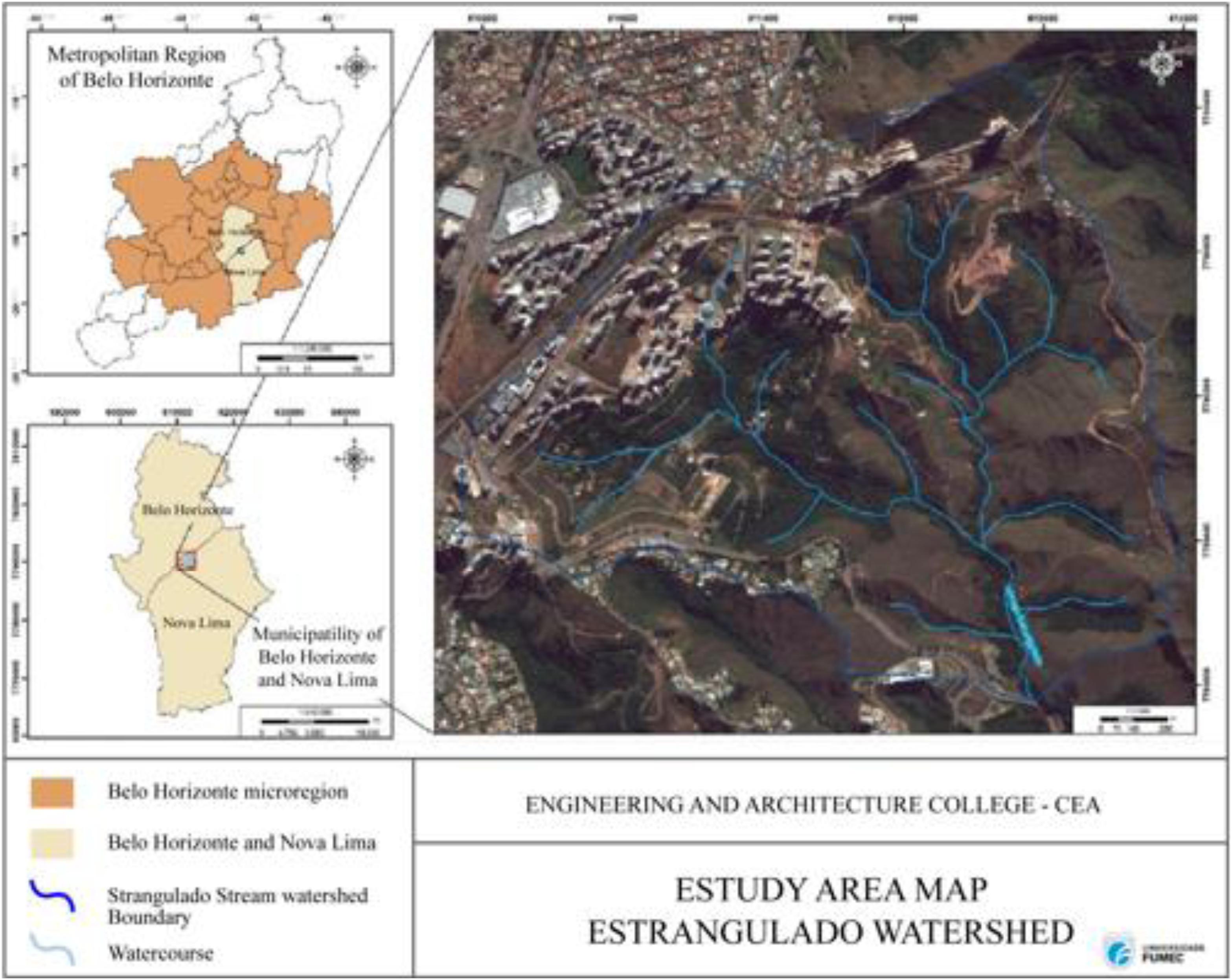
Figure 1. Location of the “Estrangulado” stream basin, Nova Lima, MG, Brazil. Source: Vieira and Almeida, 2018.
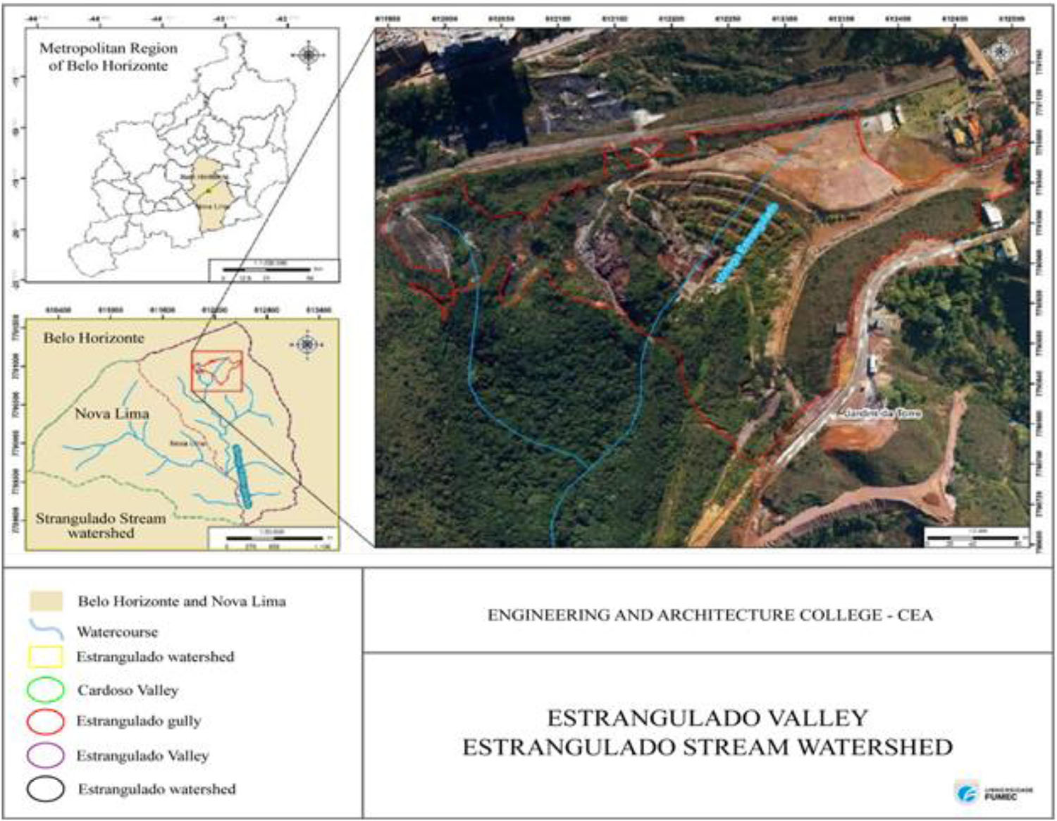
Figure 2. Study area with the location of the gullies in the “Estrangulado” stream sub-basin, Nova Lima-MG, Brazil. Source: Vieira and Almeida, 2018.
Area Recognition and Flight Planning With UAV
Field visits were carried out in April 2019 to identify “in loco” the conditions of the existing urban infrastructure, such as the presence of houses, streets, drainage, earthmoving systems (embankments, cuts), and buildings in progress. An “unmanned aerial vehicle” (UAV), model DJI Mavic Air was used to obtain aerial photographs and the subsequent creation of the orthomosaic and digital surface models (DSM) as well as the digital elevation models (DEM) (DJI, 2018). An iPhone 6 IOS device was also used, connected to a DJI remote control. On the IOS device were installed the DJI Go and DroneDeploy applications, which served as the interface between the UAV and the ground pilot to execute the flight plans.
The preparation of DroneDeploy software flight plans, the desktop version, and the flights were carried out from April 11 to 26, 2019. Three flight plans were drawn, named Estrangulado Flight 01 (F1), Estrangulado Flight 02 (F2), and Estrangulado Flight 03 (F3). The objectives and parameters for each specific flight were established according to their purposes. Frontal and lateral overlap were 70% for orthophoto capture, according to Bembras (2019).
UAV Flight Execution
The speed of the three flights was 15 m/s, recommended by DroneDeploy software for terrain mappings with 70% front and side overlap. Flight 01 was conducted at an altitude of 90 m, direction −13°, and 13:35 min of duration, covering an area of 22 hectares and capturing 209 images.
Flight 02 was performed at an altitude of 35 m, direction −19°, and lasted 13:55 min, covering an area of 2 hectares and capturing 287 images. Finally, Flight 03 was performed at an altitude of 30 m, the direction of −23° and duration of 13:55 min, covering an area of 4 hectares and capturing 235 images (Figure 3).
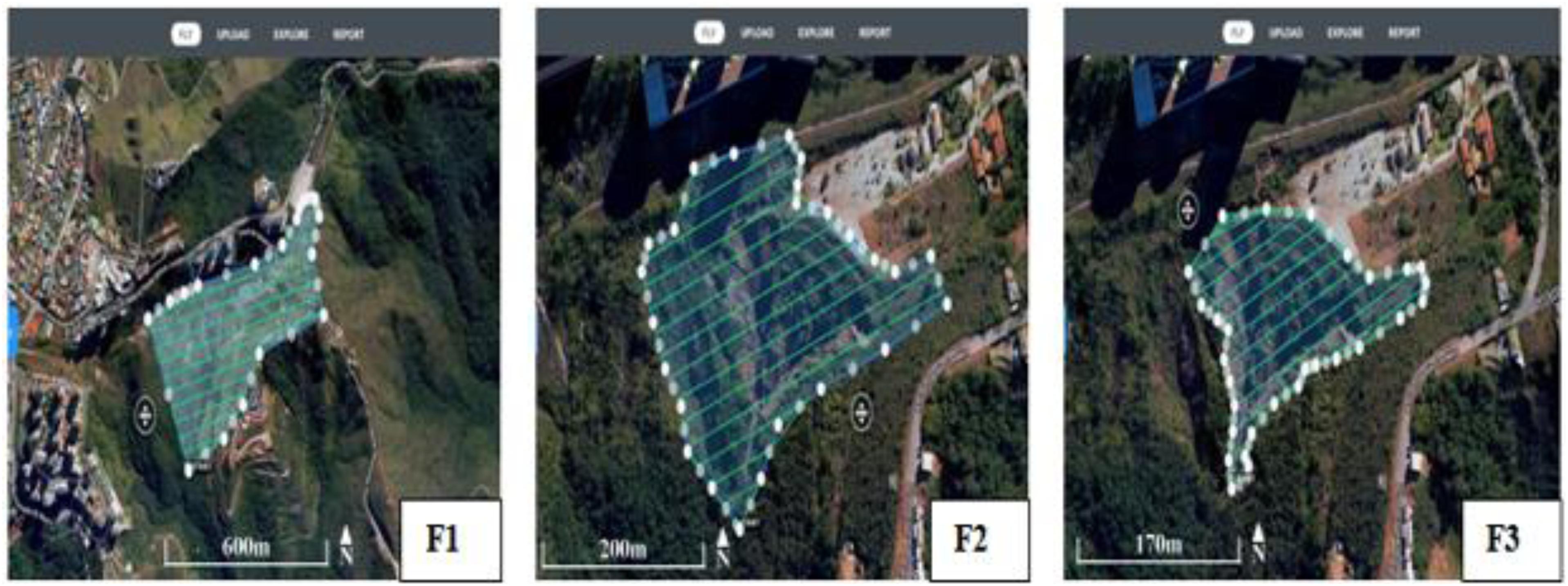
Figure 3. Flight planes covering gullies in the “Estrangulado Stream” Basin, Nova Lima, MG, Brazil. Source: (F1) Flight 01; (F2) Flight 02; (F3) Flight 03.
Gully Area and Volume Calculation
The area and volume the gully were obtained through orthomosaics generated by the DroneDeploy software, using the available measuring tools. The volumetric calculation is given by Equation 1:
Where:
V: total volume of the delimited area;
Cut: volume that must be removed to flatten the terrain;
Fill: volume that must be filled to flatten the terrain;
Also, available images of the site were obtained from Google Earth from 2002-2019. The gullies were classified according to type, shape, and size according to the methodologies of Oliveira (1999) and Vieira (2008).
Results
Occupation and Use of the Study Area
Through satellite images obtained from Google Earth, it was possible to see the real estate occupation at the site, which advanced in the region between 2002 and 2008 (Figures 4A,B).
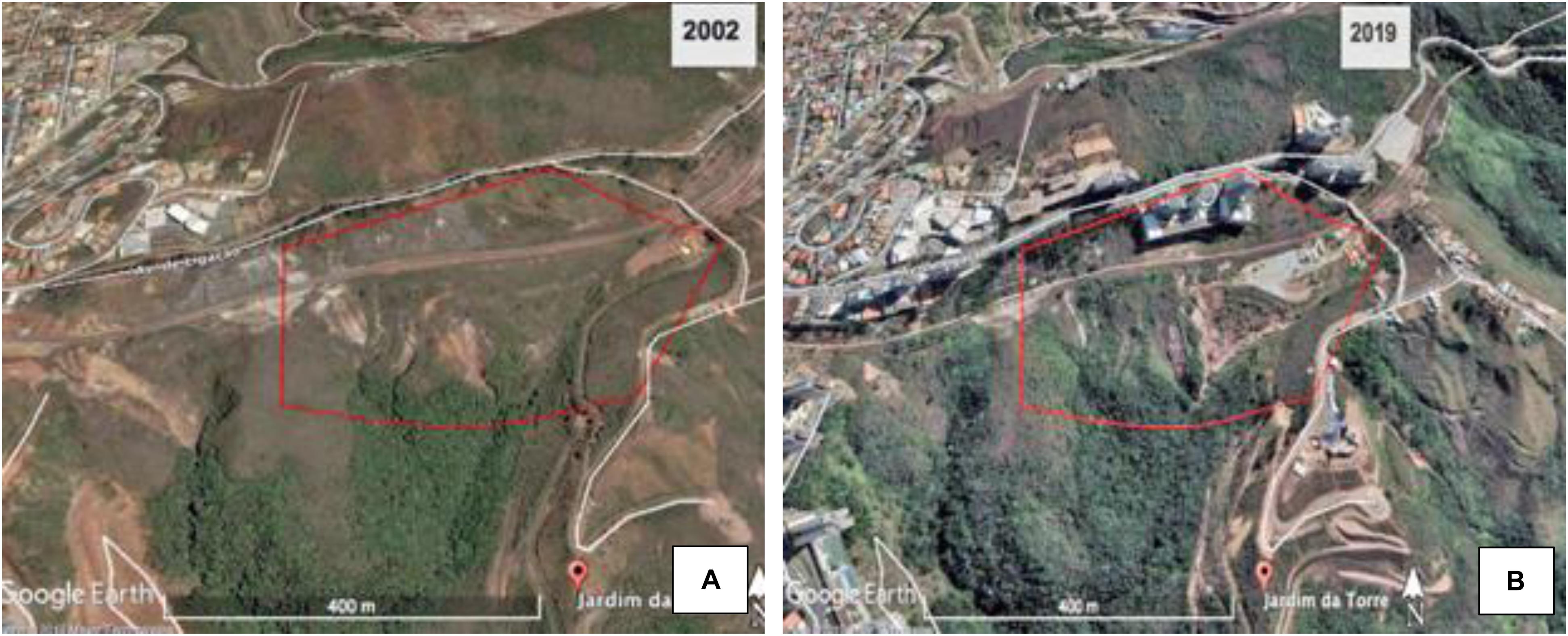
Figure 4. Location of the study area (perimeter delimited in red) between Belvedere (Belo Horizonte) and Jardim da Torre neighborhoods (Nova Lima). Source: Google Earth: (A) 2002 and (B) 2019.
The “Belvedere” neighborhood, part of the municipality of Belo Horizonte, is a consolidated neighborhood, with little space for new buildings and the “Jardim da Torre” neighborhood (municipality of Nova Lima), is still little inhabited. However, it still has large areas of environmental preservation, which have been degraded due to the removal of the original vegetation to obtain raw materials (stones, gravel, sand, gravel) and by disposal of construction waste (Figures 5A,B).
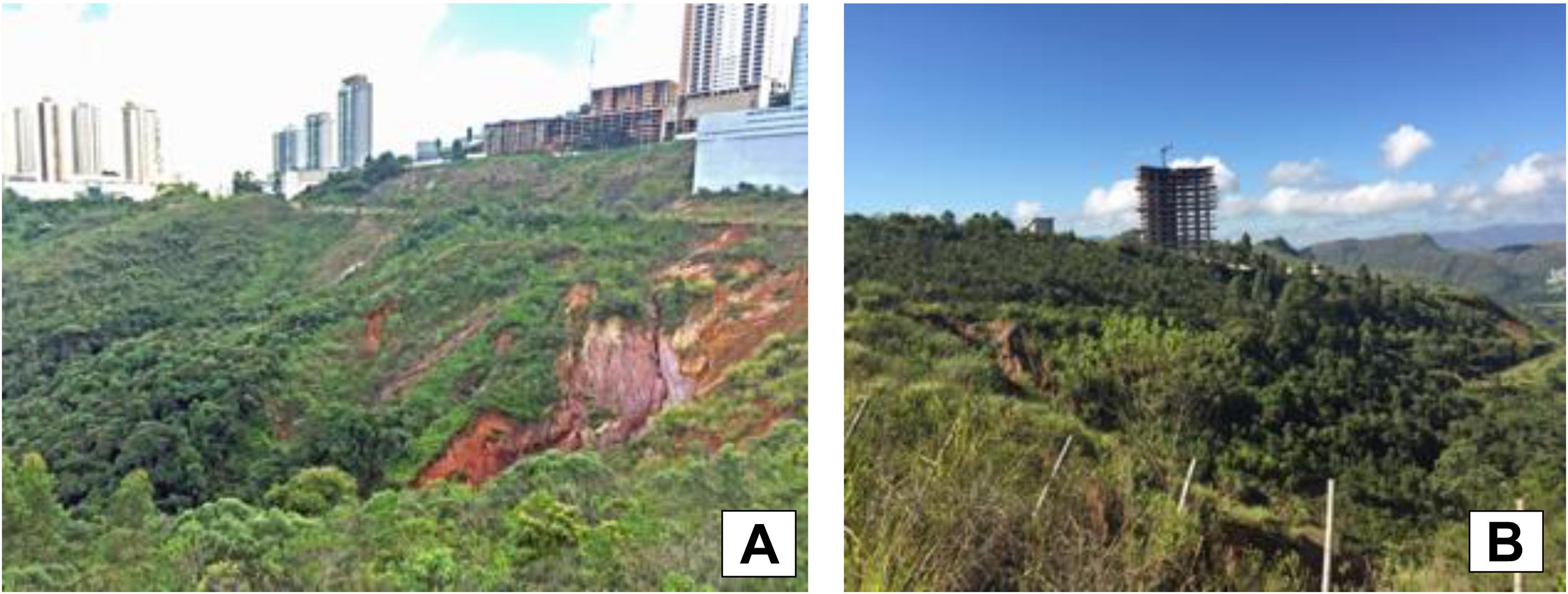
Figure 5. Study area – gullies between Belvedere and Jardim da Torre neighborhoods. (A) Lateral view of erosive processes and buildings in the Belvedere neighborhood in the background, in Belo Horizonte; (B) another angle of the gully and view of a new residential real estate development in the neighborhood of “Jardim da Torre neighborhood,” Nova Lima. Source: Authors’ personal archives.
Emergence and Evolution of the Gullies in the Study Area
Disposal of Construction Waste
The available satellite images of the area (Google Earth, 2002–2019) already show evidences of previous erosive processes, showing the partial removal of vegetation cover and a gully, named in this study “V2” (Figure 6A).
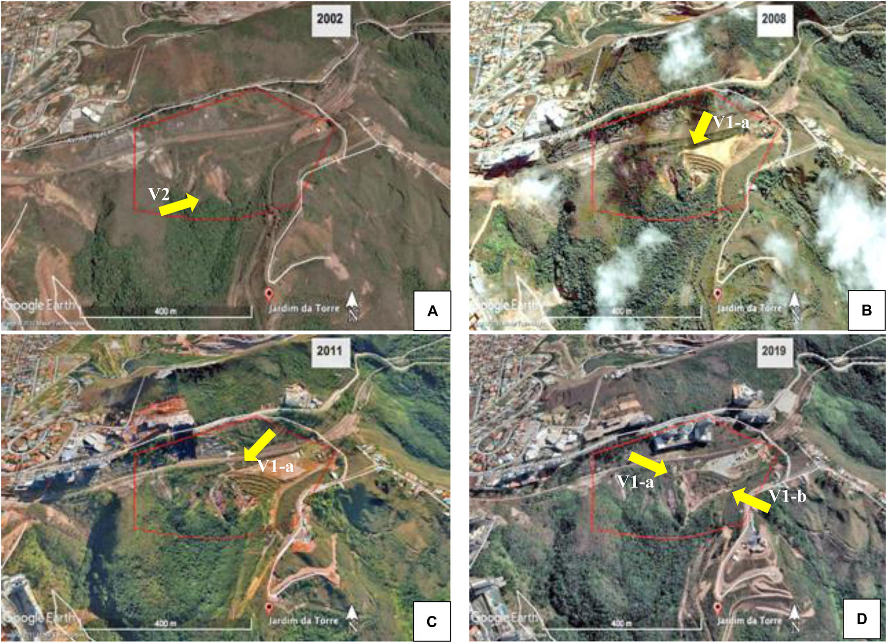
Figure 6. Evolution of erosive processes in the study area, from 2002 to 2019. (A) Arrow shows the V2 gully already existing in the area in 2002; (B) arrow shows “waste landfill” built in 2008; (C) arrow shows the onset of V1 and its first incision in 2011; (D) arrow shows the V1 and its two incisions in 2019. Source: Google Earth, 2002–2019.
Interviewed workers and residents reported that the area was used for the disposal of residues from residential condominiums complexes built in the surrounding area. These reports coincide with the satellite images of the area between 2004 and 2008, where it was possible to verify the change in the slope. It is evidenced by a method of disposing of the waste in layers from the lowest part of the valley, rising and forming a slope of waste (Figure 6B).
When waste disposal in the area ended, a new accelerated erosion process emerged forming a new gully (V1) (Figure 6C). In an attempt to contain the erosive process, a hydraulic ladder was constructed, and the construction waste landfill was covered with grass species. However, gully V1 has widened from 2011 to 2019, forming two bifurcated branches on both sides of the waste landfill (Figure 6D).
Inadequate Drainage System
The sub-basin area where soil erosion processes are taking place can be estimated at approximately 30 hectares (Figure 7A). Naturally, runoff water flows from the top to the floor of the valley, where the “Estrangulado” stream is located. However, changes in the relief (mainly in the waste landfill) caused the formation of gullies at the site (Figure 7B).
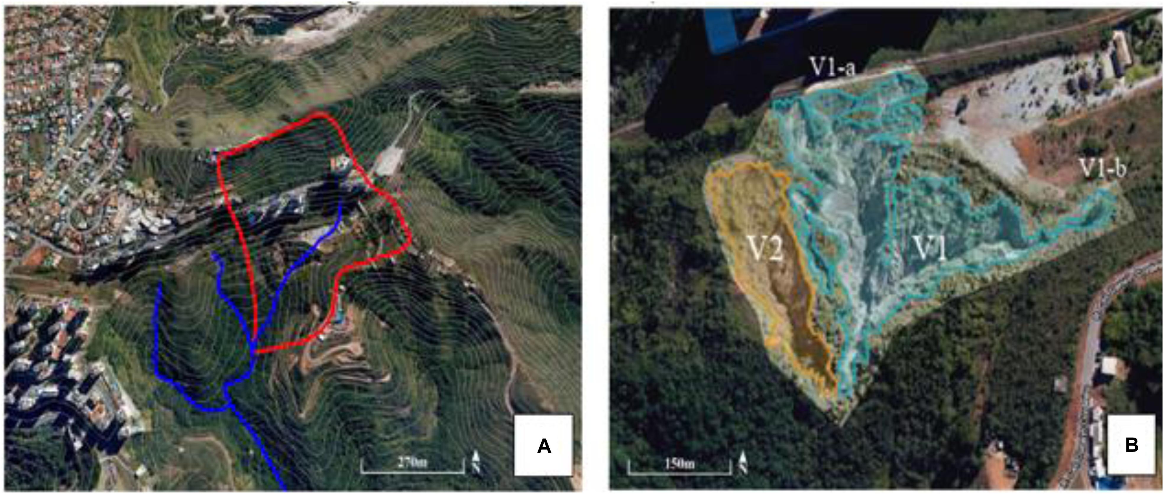
Figure 7. “Estrangulado” Stream Area and UAV aerial visualization of existing gullies in Jardim da Torre, Nova Lima -MG. (A) Água Suja/Cardoso/Cristais sub-basin, belong to “das Velhas” river basin (Source: Google Earth, 2002–2019) – the red line delimits the sub-basin and the blue line represents the “Estrangulado” Stream; (B) V1 gully (incisions 1a and 1b) and V2 gully in 2019 (delimitation made from orthomosaics).
Gully - V1
In the satellite images, it is possible to verify different modifications of the pre-existing water drainage structures. In the 2002 image, there is a canal built with the probable intention of directing the excess of water from the highest parts to the floor of the valley, where the bed of the “Estrangulado” stream is located (Figure 8A). Due to the construction waste landfill at the site, the water flow from the highest parts of the slope started to be directed to one side of the landfill, contributing to the emergence of a new ravine, identified here as V1-a (Figures 8B–D).
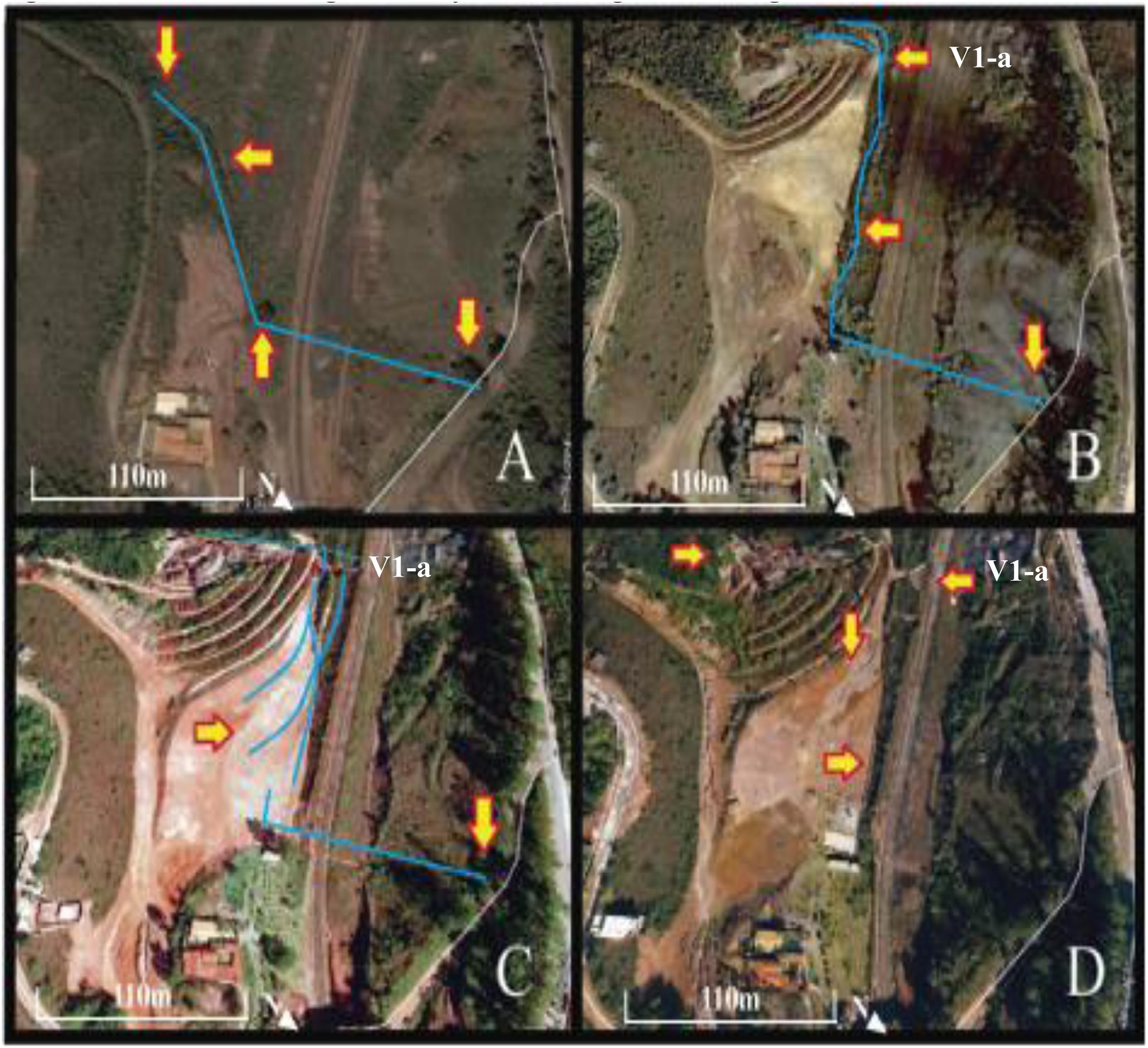
Figure 8. Satellite image history indicating the emergence of the V1-a incision. (A) Arrows show the drainage channel in 2002 (B) arrows show channel reconfigured due to the construction of the waste landfill in 2008. (C) Presence of water traces on the surface of the waste landfill plateau indicating the direction of the water flow in 2009. (D) Intensification of the erosion processes in 2011. Source: Adapted from Google Earth, 2002–2019.
As the construction waste landfill had not been made considering the slope level curves and had not been adequately compacted, such technical errors may have contributed to the onset of erosion (Figure 9A). Grass planting was also inefficient to protect the ground surface (Figure 9B). The hydraulic ladder was not correctly built either, so it cannot dissipate the velocity of stormwater runoff. Soon after its construction, the ladder collapsed inside the gully (Figure 9C). Moreover, the new ravines that were emerging were also being used for waste disposal (Figure 9D).
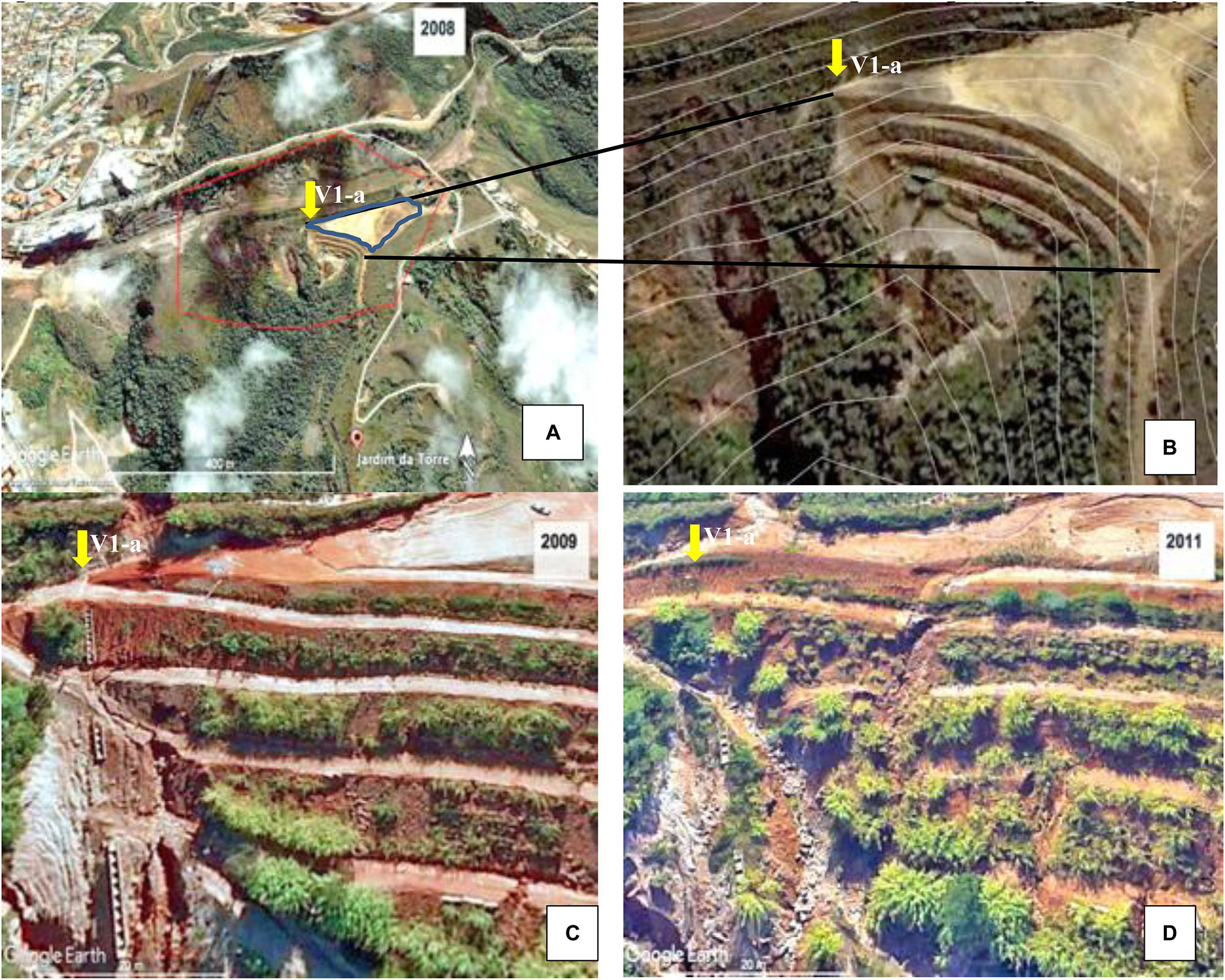
Figure 9. Detail of the embankment built for the waste landfill showing the beginning of the gully V1. (A) Satellite image of waste landfill location in the area – delimited in red and waste landfill plateau delimited in blue (2008). (B) Satellite image of the waste landfill magnified, overlapping level curves (2008); (C) Detail of the beginning of erosion on the right side of the built waste landfill and the hydraulic ladder (2009); (D) Collapsed hydraulic ladder and new erosion points at the top of the slope (2011); yellow arrows indicate the same location in V1-a. Source: Adapted from Google Earth, 2002–2019.
In 2019, it was observed that the waste landfill plateau was partially covered with gravel, and new drainage channels were built in an attempt to divert the rainwater from the top of the slope, which is now occupied by large residential buildings. The plateau currently serves as the patio of an on-site restaurant. The identified works were probably carried out by the owners to prevent flooding in the restaurant’s operating area.
Thus, it can be inferred that the inadequate construction of the waste landfill, combined with the low vegetation cover on the slopes and of the surrounding terrain, as well as the presence of an inefficient drainage system, contributed significantly to the environmental degradation of one of the streams in a relatively short time between 2004 and 2008. One of the most visible environmental impacts of this degradation is the emergence and accelerated the expansion of the V1 gully, first forming branch V1-a and later, branch V1-b.
Regarding V1-b, besides being also originated by the construction of the waste landfill, it can also be attributed to the presence of an abandoned urban road, coming from a subdivision of the “Jardim da Torre” neighborhood. The historical series of satellite imagery shows that this road was abandoned until 2004 (Figure 10A). However, it was reopened and used as a way to access the construction waste dump trucks on site between 2004 and 2008, which exposed the soil and contributed to the instability of the embankment slope (Figure 10B).
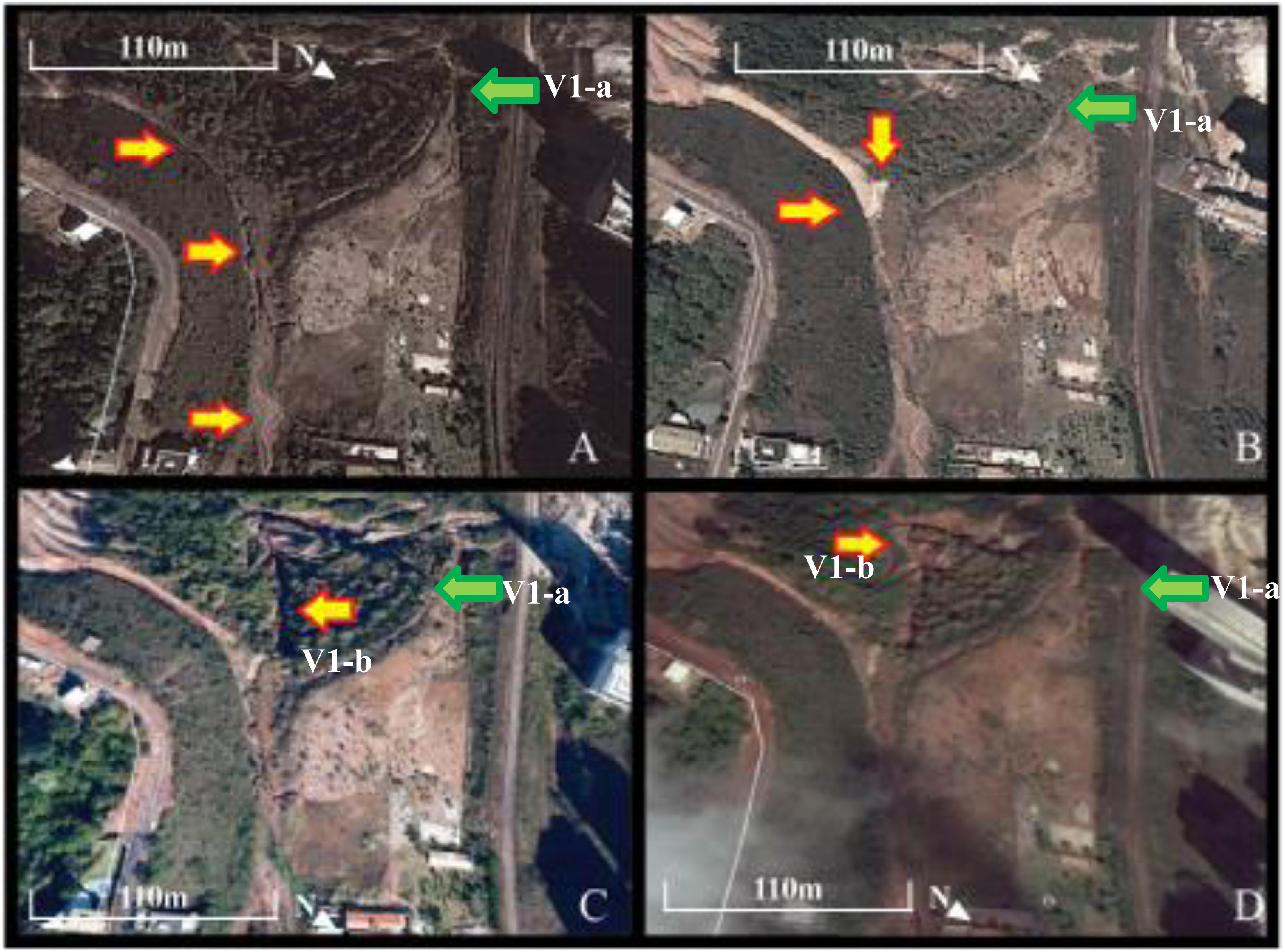
Figure 10. Satellite image history indicating the emergence of incision V1-b. Yellow arrows represent V1-b and green arrows a V1-a. (A) Presence of ravines in the abandoned road in 2013. (B) Recovery of the abandoned road in rehabilitation works of “Jardim da Torre” neighborhood in 2014. (C) Appearance of incision V1-b in 2015. (D) Intensification of the erosive process in 2019. Source: Adapted from Google Earth, 2002–2019.
These changes in the original configuration of the area led to the intensification of erosive processes at the site through runoff, creating ravines along the entire road (Figure 10C). By 2019, the V1-b incision was already connected to the V1-a incision at the floor of the valley, forming a forked gully (Figure 10D).
Gully - V2
There are no image records of the emergence of V2 gully. In the first available satellite image of Google Earth (2002–2019), their existence is already verified. From its position on the ground, it can be inferred that there was slipping of the topsoil due to reduced vegetation cover previously removed from the site (Figure 11A).
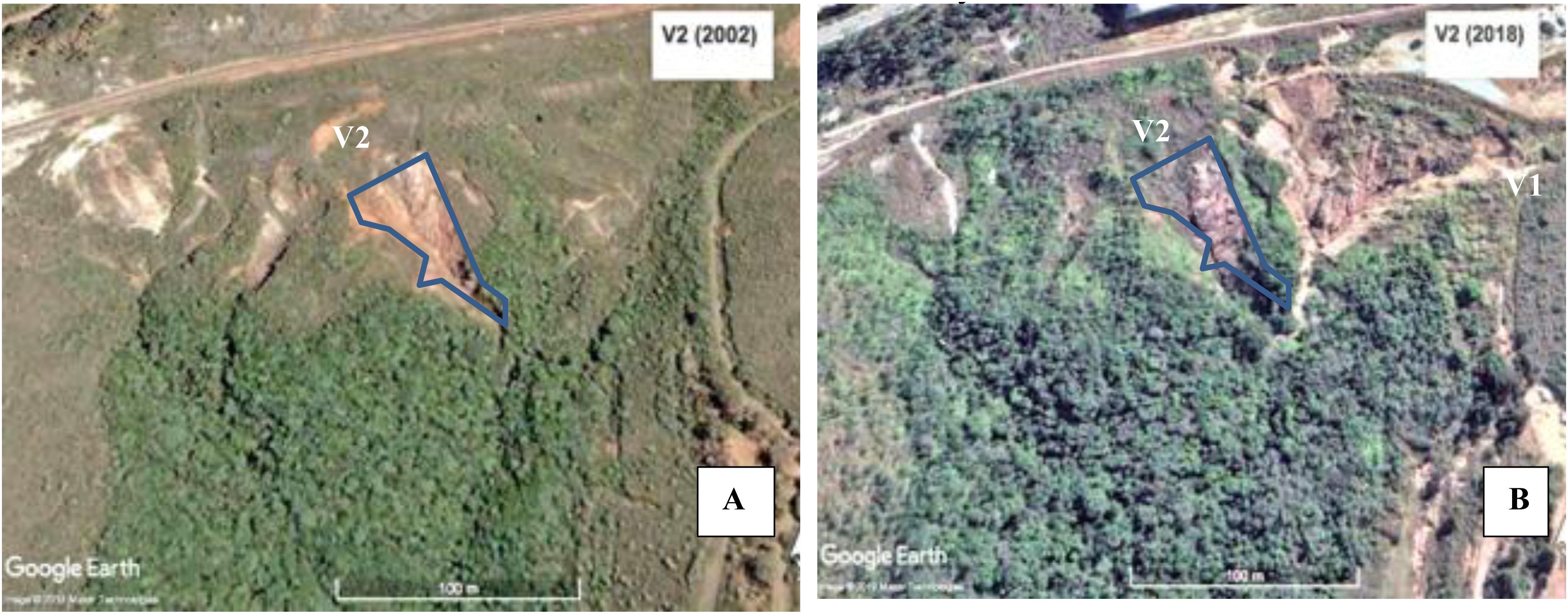
Figure 11. Evolution of Gully V2. (A) Incision of V2 gully in 2002 and (B) V2 in 2018, with V1 on its right side; gully V2 - delimited in blue. Source: Adapted from Google Earth, 2002–2019.
In the most recent available image of gully V2 (2018), it is clear that there was no significant evolution in its dimensions. However, native vegetation did not regenerate at the site (Figure 11B).
Orthomosaic, Gully Surface and Elevation Model
From the images obtained during the flights with the UAV, orthomosaic and surface models (MDS) and elevation models (MDE) of the gullies can be obtained. The DroneDeploy software uses relative elevation data in map processing. Elevations are not expressed relative to the WGS 84 Global Reference elevation system. They are expressed in meters above or below the drone takeoff point, i.e., the software considers the reference surface to be the drone takeoff location (DroneDeploy, 2019). The DroneDeploy software, in automatic mode, also selects a fast shutter speed on the drone’s camera to compensate image distortions and aberrations.
With the MDE of the area surrounding the gullies, it was found that the land has an elevation difference of 144.5 m, from the lowest point to the highest point of the slope. The head of the V1 gully was used as a takeoff point for the drone. It was possible to verify an average difference in elevation of the gullies of 84.75 m, considering the distance between the head of the gully (surface to be the drone takeoff location) and its lowest point on the slope (Figure 12).
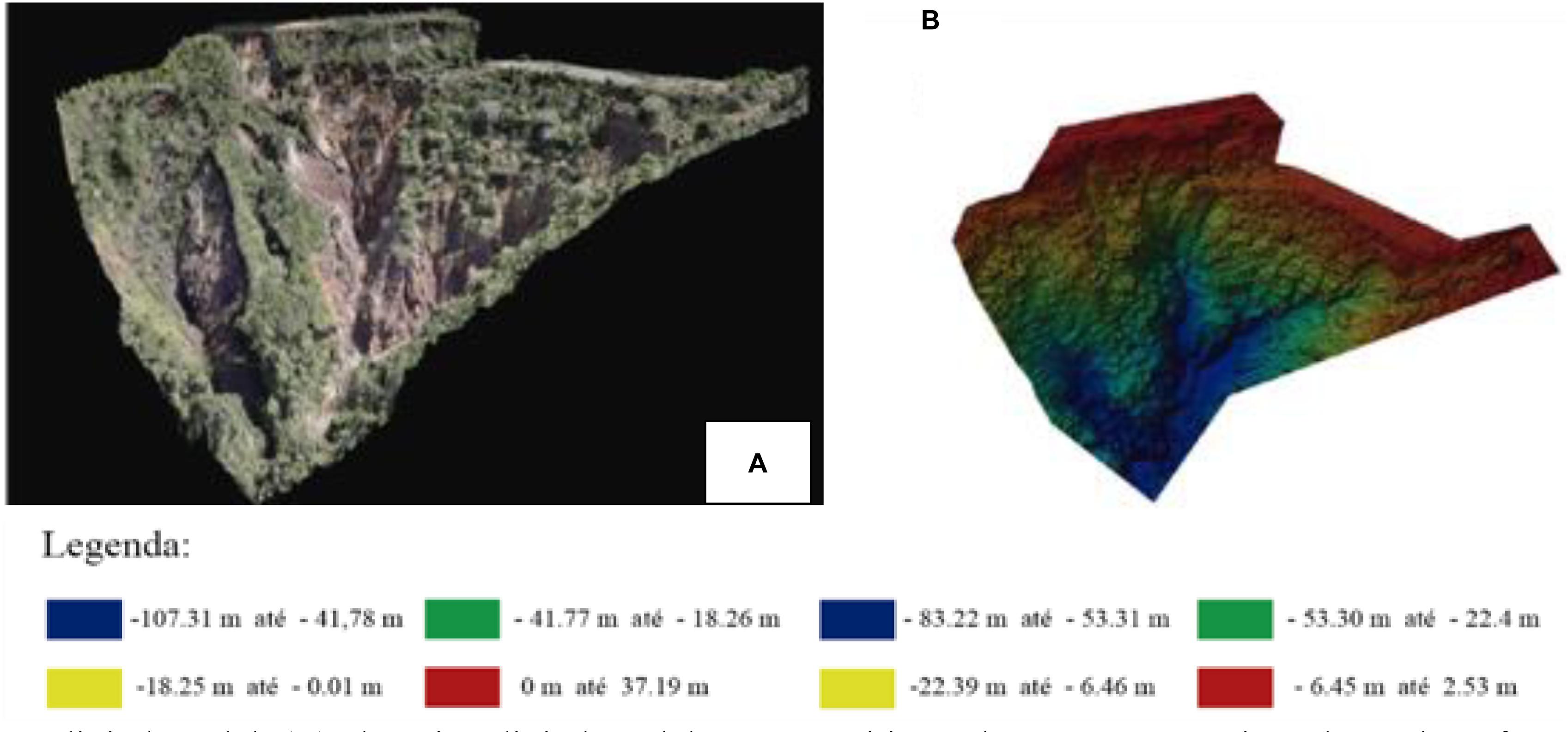
Figure 12. Gullies surface and digital elevation models in the study area, Nova Lima-MG, Brazil. (A) Surface digital model; (B) elevation digital model. Positive values represent points above the reference and negative values represent points below the reference (in meters). Reference (drone takeoff point = 0 m).
An important point noted was related to the accuracy of orthomatics about absolute precision (global precision). Absolute precision is the degree of fidelity at which a location on a map corresponds to its real position in a fixed coordinate system in the real world. Absolute precision can have errors of up to 1 m in relation to horizontal precision and up to 3 m in relation to vertical precisión (DroneDeploy, 2019). In the orthomatics generated, discontinuities of drainage structures and the terrain were observed, thus indicating errors of absolute precision. For this problem to be solved, it is necessary to use Ground Control Points (CGP), and preference can be given to more complex GPS systems, such as RTK (Real Time Kinematic) or PPK (Post Processed Kinematic).
Land Coverage Analysis
Through the Plant Health tool, which uses the DroneDeploy software’s Visible Atmospherically Resistant Index (VARI) algorithm, it was possible to observe the relationship between exposed soil and vegetation cover within and around the gully. This algorithm compares the proportions of light captured across different bands (red, green, and blue) to calculate numerical values for each pixel or area of a given map. In addition to Plant Health, VARI measures the reflectance of vegetation and soil, making it possible to identify vegetation-covered soil (green) and uncovered soil (exposed) (red).
Gully V1 had a much larger area with exposed soil than the area with some vegetation (Figure 13). When visiting the site, it was noticed that this vegetation is predominantly of herbaceous species, with grasses and some legumes. The floor of the valley is more preserved with denser vegetation and also composed of larger species.
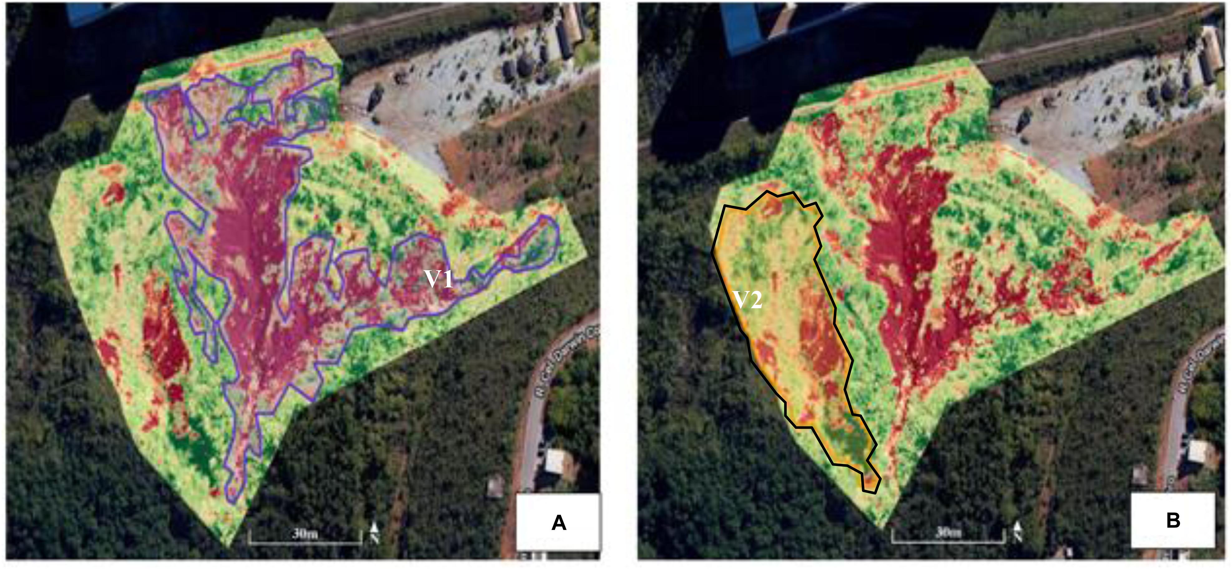
Figure 13. Vegetation and bare soil in gullies V1 and V2. Red tones = bared soil; green tones = vegetation. (A) The lines delimit the gully V1; (B) the lines delimit the gully V2.
On the other hand, V2 gully presented a more substantial area with more vegetation than V1 gully. This fact could indicate that V2 is in the process of stabilization, considering that no ground movement has been identified since 2002 in its area, according to the available satellite images.
Estimate of Expansion of Gullies Area
To quantitatively compare the expansion of gullies V1 and V2 over time, we used the Google Earth area measurement tool. Subsequently, the results were compared with the values of the areas presented by the gullies in the current period, obtained through the DroneDeploy software and the generated orthomosaics. For the 2019 calculations, the generated orthomosaics were used.
However, between 2002 and 2019, it had a growing expansion, more significantly after 2009. The eroded area in the V1 gully increased 2.37 times from 2009 to 2019. In the V2 gully, the expansion was smaller, that is, less soil/sediment loss. In the 2009–2019 period, the estimated areas were very similar, indicating the stabilization of V2 (Table 1).
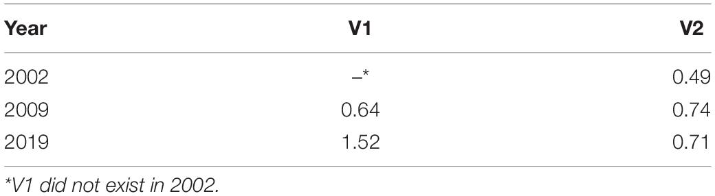
Table 1. Area in hectares of gullies V1 and V2 over the years.
The Linear Fit Algorithm (DroneDeploy, 2019) was used to calculate the volume of the gullies. This algorithm interpolates a reference surface above the gully cavity, based on the adjacent relief, considering the edge points of the plotted perimeter. It was assumed that the difference between the interpolated reference surface and the gullies surface, from the generated DSM, represents the following eroded soil estimates, 68,195.5 m3, and 49,409.7 m3, for V1 and V2, respectively. These values were only estimated, considering that there were no “control points on the ground.”
Discussion and Conclusion
Area Occupation and Use History
From the 1950s, the opening of the BR 040 highway, which connects Belo Horizonte to Rio de Janeiro, led to the development of land subdivisions on its banks in the municipality of Nova Lima. However, these lots remained mostly unoccupied for many years (Pires, 2003). Only in the late 1970s, with the urban expansion of Belo Horizonte in that direction and, especially, with the construction of the first shopping center of Belo Horizonte, in an area bordering the two municipalities, there was great interest and appreciation of the lots. Besides, in a period of closure of many iron and gold mines, land owned by mining companies became the new source of capital for these companies (Silva and Machado, 2014).
According to the information of the Nova Lima City Hall, of the 427.7 km2 of the Nova Lima territory, 91% of the available areas (vacant lots) are in the hands of individuals, mainly mining and real estate companies. The concentration of land ownership in Nova Lima, therefore, underscores the process of private production of its space (Menegale, 2002).
As reported by the Preliminary Diagnosis of the Nova Lima (2006a, b) Municipal Development Master Plan (2006), the mining process has left degraded areas that need recovery and gradually become part of the private subdivision of land or other urban uses. In turn, the municipality adopted an urban policy to encourage the private subdivision of land for sale. The municipality of Nova Lima has approved approximately 50 subdivisions from previously mining areas. Allotments are totaling approximately 25,000 units, mostly destined for the higher income groups, involving a potential population of 100,000 inhabitants (Mendonça, 2003).
From the 1990s, the urbanization process is even more intensified in the region. Neighborhoods between Belo Horizonte and Nova Lima are undergoing a process of rapid verticalization. This fate, allowed after successive changes in public land use and occupation legislation (Machado and Assis, 2016), lead to increasing pressure on the natural environment in that area. However, according to a recent revision of the Municipality Master Plan, allotments before the Municipal Use and Occupation Law (BRASIL. Lei n. 6.766/79, de 19 de dezembro de, 1979) (Law 6766/1979) are considered irregular by the city, as is the case of the private subdivision of Jardim da Torre (Nova Lima, 2014).
The focus of this study was to verify how this urban expansion, without planning criteria, led synergistically to the modification of the local landscape and the degradation of natural resources. The region is identified as environmentally fragile because it has original vegetation of the “Atlantic Forest” biome with the presence of “Cerrado” vegetation and soils susceptible to the occurrence of various erosion processes, especially in deforested areas (Ferreira and Almeida, 2016).
According to Costa (2003), there are conflicts in the process of urban expansion in this region, as there are areas of environmental preservation and mineral exploration in the region. In addition, there is a concentration of land in the hands of mining companies and the proliferation of municipal permits for the construction of new residential buildings. In other words, a conflict that highlights the need for long-term planning, including environmental preservation and urban growth. In turn, Lemos and Magalhães Junior (2019) pointed out that the impact generated by mining and urban expansion represents fragile contexts for the region’s environmental function as a water supply source for the metropolitan region.
The local relief is wavy and mountainous, very dissected, with substantial unevenness and altitude ranging from 700 to 1200 m and predominant slopes above 30% (Perna, 2012). According to the Nova Lima Letter of Susceptibility to Mass Gravity Movements and Floods (Leão, 2016), the area has a “medium” and “high” susceptibility class for mass gravitational movements. Lithology is composed of quartzite, schist rocks, serpentinites, and iron formations, containing sliding processes. According to De Oliveira Costa et al. (2014), schist rocks have low cohesion and are poorly resistant to erosion, especially when natural vegetation is removed and roads are implanted. The soils that occur locally are Cambisols, associated with Lithological soils (Davis et al., 2004).
These morphological and lithological substrates are hostile to urbanization. Its implementation requires, in most cases, very radical earthmoving interferences that disfigure the features of this landscape and expose the area to erosive risks (Nova Lima, 2006a). According to FEAM (2001), areas of a high slope, when related to the fragile rocks that form the subsoil, may present deficiencies caused by inadequate urbanization processes. These inadequacies are the removal of vegetated areas, shallow soils, the adequacy of the road system to the relief, using cuts and embankments that do not respect the geological characteristics of the support rocks, especially on the slopes of the “Curral” ridge.
Thus, in general, it can be said that the angle inclination and shape of the slopes of the region, when modified without proper management, can trigger erosive processes, accentuated by the natural conditions of the land, increasing the geological risks. The relationship between rocks and soils is influenced by other aspects, such as hydrology and vegetation, which may interfere with the carrying capacity of the support. In the region, the vegetation consists of remnants of seasonal semideciduous forest, found mainly in the areas declared as nature reserves (Perna, 2012). For these reasons, most of its still preserved areas are protected by the Organic Law of the Municipality. The study area is part of the “Vila da Serra” Special Guidelines Area (ADE Vila da Serra), created by the Master Plan - Municipal Law 2007 of August 28, 2007.
At the same time, environmental preservation has also become an attraction to the higher income classes, favoring more allotments on site. The population in ADE Vila da Serra increased by six times, and households increased by seven times in the period (2000 – 2014) (Nova Lima, 2014).
Under the Nova Lima Master Plan diagnosis, population growth was not due to the installation of new large industries, nor to the migration of workers to the mining industry. There is significant residential mobility of the population of Belo Horizonte, following a migratory flow to the municipality of Nova Lima in the region closest to the capital. This occupation is done with the predominance of a social class of high purchasing power composed of senior managers and professionals, living in luxury closed condominiums, characterizing the elitism of space (Mendonça, 2003).
Emergence and Evolution of the Gullies in the Study Area
Clandestine Disposal of Construction Waste
At the time of the construction of the waste landfill in the study area, the Organic Law of Nova Lima (1990) already stated that “…the Municipality will maintain a system of urban cleaning, collection, treatment and final disposal of garbage.” Besides, since 2002, the municipality already has an inert landfill (which includes construction waste) under city management (Nova Lima, 2015). Municipal solid waste management services are a responsibility of the Municipal Department of Urban Works and Services (SEMOS).
The legislation of Minas Gerais State (Law 10.793/1992), which provides for the protection of springs destined to public water supply, prohibits the installation, in the hydrographic basins, of several projects with polluting potential, including “garbage deposit and landfill restroom.” While Law 13.199/1999, provides for the State Water Resources Policy, which highlights the need to avoid the adverse effects of pollution, floods, and soil erosion.
In Nova Lima, in 2013, construction and other bulky waste represented a volume of 40,461 tons of waste, of which 4,498 tons were generated by the public sector and 35,963 produced by the private sector (Brazil, 2014). So far, no fee is charged for the collection of construction waste in the municipality. Also, when requested, SEMOS collects waste of this type free of charge when in small quantities (Nova Lima, 2015). In this context, it can be deduced that the disposal of waste in the area was done clandestinely. The area corresponds to the source of the “Estrangulado” stream, a tributary of the “Cardoso” stream, and therefore, is a Permanent Preservation Area, protected by federal environmental laws, in particular, Law 9605/1998 (BRASIL Lei n° 9.605, de 12 de Fevereiro de, 1998); Law 11428/2006 and Law 12651/2012 (DOU, 2012).
Inadequate Drainage, Sewage Collection and Treatment System
The Nova Lima sub-basins are the principal tributaries of the “das Velhas” river, with the “Cardoso” stream being the third-largest long-term average flow (1.78 m3/s) (Nova Lima, 2015). Since 1977, the importance of protecting the “das Velhas” river basin has been recognized (Decree 18,782/1977).
In turn, the Master Plan of Nova Lima (2007) (Law 2007/2007) highlights that “Adequate drainage of rainwater in the municipal territory will be ensured and all pollution and any unlicensed action or intervention will be prohibited, which implies the reduction of water potential.” It also establishes the guidelines for basic sanitation “. require the control of waste generation and treatment for large projects potentially generating polluting loads, articulated with the control of drainage flows.” Finally, it lists the objectives of the urban drainage system, among them, “. to elaborate and implement the Municipal Drainage Master Plan, integrating it with the Upper Velhas Stream Basin macro drainage Plan and the Municipal Plan Environmental Sanitation.”
The municipal drainage system depends mostly on surface runoff. Rainwater drainage channels are rare, causing flooding at some points along river banks, and generating erosive processes that lead to siltation of watercourses (Nova Lima, 2006a). By 2019, the municipality’s Drainage Master Plan had not yet been approved. Due to the deficiency of the urban rainwater micro drainage system in the region, particular interventions occur, without proper planning and probably without the knowledge of the city, as is the case observed in the study area.
According to the Nova Lima (2015) Basic Sanitation Diagnosis, practically all water bodies that pass through or near urban agglomerations are impacted by domestic sewage contamination “in natura.” In the area of this hydrographic sub-basin, it is the largest population concentration, which leads to great pressure on water resources. In addition, there are points of release of domestic sewage in rivers, since the municipality does not have a Sewage Treatment Station, which meets all the population’s demand. Thus, the new buildings domestic sewage is released in septic tanks, as is the case in the “Jardim da Torre” neighborhood, where the study area is located. A study of the water quality found high pollution, due to the release of domestic sewage and sediments in the “Cardoso” stream (Trindade et al., 2017).
Another environmental impact factor in the municipality water sources is the contamination that may be associated with mining exploitation in the region “das Velhas” river basin (Camargos, 2005). According to the Nova Lima (2004) Water Revitalization Plan Diagnosis, the presence of zinc, soluble iron, copper, and lead in the “Cardoso” Stream was detected above the allowed values. Thus, the loss of quality of these springs causes the increase of water treatment costs for public supply and puts the health of the population at risk (Nova Lima, 2015).
Soil Coverage Analysis
The study area is on a slope of the monoclinal ridge of “Serra do Curral”. According to the Nova Lima (2006a) Master Plan Diagnosis, the slopes located there are covered by grassy fields, which have a very typical physiognomy, composition, and structure, without the presence of trees, with typically herbaceous and rare stratum shrubs, which can be found more frequently on slopes, plateaus, and spring waters. These fields without anthropic action occupy different positions in the relief, but predominate in higher elevations on shallow soils (underdeveloped Cambisol or Lithosol) and tend to be rupestrian fields, on the highest elevations of the terrain.
It is also possible to find other typical “Cerrado” vegetation, which gradually follows from the crest to the base. The tropical forests extend into the valley floor, with the savannahs located between grassy fields (Ab’Saber, 1977). In the study area, a large part of the native vegetation was removed or covered with construction waste during the waste landfill and, subsequently, by erosion processes. Consequently, the V1 gully has much of its uncovered area, i.e., with exposed soil (Figure 13). It was observed in the study area, that there is a breakdown of the gully head at various points and also of the built slope. In these processes, many plants that start to settle in the area, are uprooted and dragged by erosion. The regeneration of the vegetation on the site is slow, as can be seen in V2, already existing at the site, before the landfill (2004), and until 2019, we notice the predominance of grasses (secondary succession). These observations corroborate the estimated soil volume/eroded sediment in gullies.
Gullies’ Expansion
The proper spatial resolution of orthomosaics allowed us to characterize more accurately the shape and size of each gully since this information depended directly on the accuracy when establishing the erosion border lines. The study of Yang et al. (2019) showed that combining historical aerial photographs and modern UAV remote-sensing observations can compensate for the lack of monitoring data for long-term gully development. These methods are also useful for monitoring changes in topography and geomorphology. Similarly, Gudino-Elizondo et al. (2018) used UAV images and orthomosaic confection to determine the area and volume of eroded soil in gullies in Tijuana, Mexico.
In 2014, Vieira and Almeida (2018) studied the same gully (V1) here studied and found an expansion of the gulley border lines at a rate of 0.17 m/month. The authors warned that the advancement of that gully could cause instability and risk to the surrounding buildings.
In the present work, measurements were taken of the satellite image of the gully obtained from Google Earth, and it was estimated that in 2014, the area of the gully V1 was approximately 1.2 hectares. In the current study conducted in 2019, it was estimated for the same gully (V1), an area of 1.52 ha, an expansion of 26% compared to 2014. Regardless of the estimated area and volume values, the progress of erosion processes is visible from satellite images, from images also obtained by the drone and visually at the site. The increase in the area of the V1 gully found over the years is also associated with the low percentage of soil cover, and the flow of rainwater directed to it (Figure 14).
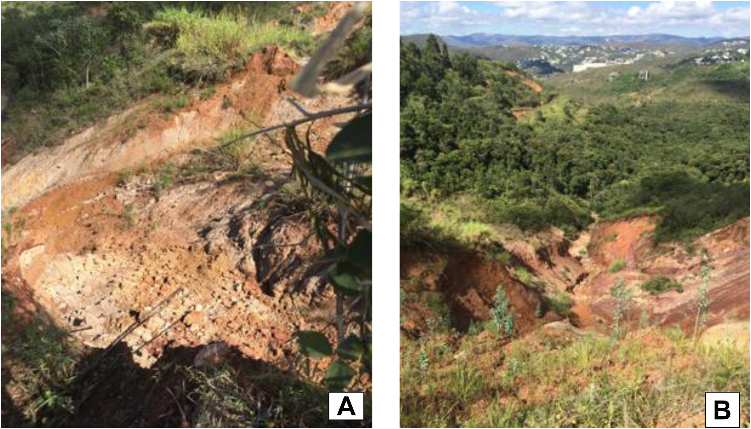
Figure 14. Degradation in the head and sides of the V1 gullies in 2019. (A) Loose soil at the headland and slope of gully V1; (B) view of the headland of gully V1, still showing the valley’s floor protected by native vegetation.
These are phenomena that are intensifying environmental degradation at the site and require mitigation measures for these impacts. For example, sedimentation in lakes and reservoirs reduces life span and affects operation efficiency and costs, and in harbors and estuaries it requires dredging and its associated costs (FAO, 2019). Soil erosion also contributes to pollution of waterways by nutrients and by other agrochemicals such as pesticides. This pollution leads to eutrophication of waterways and the resulting impact on aquatic life as well as direct toxicity effects on organisms (Owens et al., 2005).
About the other gullies in the area (V2), it was observed that the fact that the eroded soil volume was very similar in 2009 and 2019 might be a sign of stability. However, it is important to note that the two gullies (V1 and V2) are very close, being separated only by a column of soil and may collapse in the future.
Concerning mitigation measures, consideration should be given to the elaboration of a Degraded Areas Recovery Plan (DARP), discussed and approved by all sectors involved, i.e., municipal government, owners of the vacant land, residents and traders. The DARP should consider municipal and state environmental laws, as well as the Belo Horizonte Metropolitan Plan. Tonucci Filho and Freitas (2020) pointed out that the Belo Horizonte Metropolitan Plan warns that the proposal for new urban centers in the Southern Vector, to which the area under study belongs, should give a different treatment to the densification of the region, considering the relevance in preserving water resources and fragments of native vegetation.
There are several technologies available and affordable to mitigate the advance of erosion processes linked to gullies. For example, in the Republic of Congo, a study on origin and control of gullies concluded that mega-gully treatment follows two principles, often combined. The first is to stop the alimentation of the mega-gully head with water. The second includes a complete stabilization of the channel and walls inside the mega-gully (Imwangana et al., 2015). Besides that, use soil bioengineering techniques, such as the use of geotextiles associated with grass and legume vegetation, as used in the stabilization of a gully in an urban area of São Luís, Brazil (Guerra et al., 2015), fascinas (use of vegetated barriers) (Frankl et al., 2018), and terraces (Yang et al., 2019).
The study of Costa et al. (2018) evaluated geodynamic processes in an area of peri-urban headwaters of a hydrographic basin located in the southeastern region of Brazil. The authors suggest that some basic guidelines reconcile economic development and preservation of ecosystem services provided by the basin, especially in terms of surface and underground supply of good quality water. Among them: restore the areas of natural vegetation at the interfaces, mainly on the ridge surface in areas where a higher surface level was found; advocates mandatory protection of damp areas up to 10 m in width want these areas to serve as natural filters that can contain the sedimentation originating from the higher zones; and create a priority zoning for the restoration of degraded areas.
Also, it is essential to highlight the contribution of the use of UAVs to enable studies of erosive process monitoring and the efficiency of specific recovery techniques. This study demonstrated that there is a high degree of image fidelity in a short period, without having to enter the site, ensuring convenience, safety, and efficiency in the data collection of the study area. Although it is possible to carry out similar studies using only satellite images available on the Internet for free or even purchased, the use of UAVs allows a more detailed view of the area and an accurate extraction of information. So, it must be considered the best cost-benefit when comparing the price of UAV with the price of satellite images. In addition, UAV is more simple when dealing with image processing software and, finally, greater flexibility in adverse weather conditions.
The study by Wang et al. (2016) indicates that the use of remote sensing data from several sources, including satellite and UAVs images simultaneously, results in an adequate assessment of gutter erosion at various spatial scales. The combined approach must be continued to regularly monitor gully erosion to understand the erosion process and its relationship to the environment from a comprehensive perspective.
Urban expansion in a troubled region of the municipalities of Belo Horizonte and Nova Lima, Minas Gerais, Brazil, has significantly changed the local landscape and has promoted the degradation of permanent environmental protection areas. The work in question exemplifies the existing counterpoint between economic interests and environmental preservation. The clandestine disposal of construction residues on the “Estrangulado” stream and the formation of gullies on site reflect the neglect of municipal and regional ecological-economic zoning, as well as a non-compliance with current environmental legislation.
Despite existing environmental and urban planning instruments, current environmental legislation, and awareness among the resident community, the area continues to suffer from real estate pressure, which could aggravate the environmental and health situation of the site, compromising ecosystem resilience and supply RMBH water. However, there are technical alternatives to recover the area environmentally and requalify it for the community, valuing the most attractive of the region, which is the natural landscape itself. This study exemplifies some of the environmental impacts caused by urban expansion in metropolitan areas.
Data Availability Statement
All datasets generated for this study are included in the article/supplementary material.
Author Contributions
RE performed drone flights, data analysis and article writing. VM collaborated in the analysis of the data. VZ collaborated in the data analysis and wrote the article.
Funding
This work was supported by Federal Center for Technological Education of Minas Gerais.
Conflict of Interest
The authors declare that the research was conducted in the absence of any commercial or financial relationships that could be construed as a potential conflict of interest.
Acknowledgments
We thank Rafael T. L. L. Vieira and Eliana S. F. Almeida for sharing his previous studies on the area under study.
References
Adediji, A., and Ibitoye, M. O. (2013). Urban gully development in Southwestern Nigeria. Positioning 4:183. doi: 10.4236/pos.2013.42018
Adediji, A., Jeje, L. K., and Ibitoye, M. O. (2013). Urban development and informal drainage patterns: gully dynamics in Southwestern Nigeria. Appl. Geogr. 40, 90–102. doi: 10.1016/j.apgeog.2013.01.012
Angel, S., Blei, A. M., Parent, J., Lamson-Hall, P., and Sánchez, N. G. (2016). Atlas of urban Expansion—2016 edition, Volume 1: Areas and Densities. Middle Town, CT: Choice Reviews Online, doi: 10.5860/CHOICE
Awange, J., and Kiema, J. (2018). “Unmanned aircraft vehicles,” in Environmental Science and Engineering (Springer Nature Switzerland: Springer, Cham), 265–289. doi: 10.1007/978-3-030-03017-9_20
BRASIL. Lei n° 9.605, de 12 de Fevereiro de 1998. Dispõe sobre as Sanções Penais e Administrativas Derivadas de Condutas e Atividades Lesivas ao Meio Ambiente, e dá Outras Providências. Available online at: http://www.planalto.gov.br/ccivil_03/leis/l9605.htm (accessed March 20, 2019).
Camargos, L. M. M. (2005). Plano diretor de recursos hídricos da bacia hidrográfica do Rio das Velhas: resumo executivo dezembro 2004/Luíza de Marillac Moreira Camargos (coord.). Belo Horizonte: Instituto Mineiro de Gestão das Águas.
Carvalho, J. D., Sales, M. M., Souza, N. D., and Melo, M. D. S. (2006). Processos Erosivos No Centro-Oeste Brasileiro. Brasília: Universidade de Brasília.
Castillo, C., and Gómez, J. A. (2016). A century of gully erosion research: Urgency, complexity and study approaches. Earth Sci. Rev. 160, 300–319.
Cherem, L. F. S. (2008). Análise Morfométrica da Bacia do Alto Rio das Velhas: Comparação de Metodologias e Dados. Master’s thesis, University of Minas Gerais, Belo Horizonte.
Companhia de Pesquisa de Recursos Minerais [CPRM] (2005). Projeto APA Sul RMBH: Uso e cobertura Da Terra, Mapas Cobertura E Uso Da Terra, Escala 1:50.000. Belo Horizonte: CPRM.
Costa, C. W., Lorandi, R., and de Lollo, J. A. (2018). Surface runoff and accelerated erosion in a peri-urban wellhead area in southeastern Brazil. Environ. Earth Sci. 77:160. doi: 10.1007/s12665-018-7366-x
Costa, H. S. M. (2003). “Natureza, mercado E cultura: caminhos da expansão metropolitana de BH,” in População, Espaço e Gestão na Metrópole: Novas Configurações, Velhas Desigualdades, eds J. G. Mendonça, Godinho and L. Maria Helena (Belo Horizonte: PUCMinas), 159–179.
Coulon, F., Jones, K., Li, H., Hu, Q., Gao, J., Li, F., et al. (2016). China’s soil and groundwater management challenges: lessons from the UK’s experience and opportunities for China. Environ. Int. 91, 196–200. doi: 10.1016/j.envint.2016.02.023
Curi, L. F. (2019). Plano Diretor de Nova Lima: Uma Abordagem Frente aos Principais Processos de uso e Ocupação do Solo no Contexto do Planejamento Urbano Brasileiro. Master’s thesis, University of Minas Gerais, Belo Horizonte.
Davis, E. G., Andrade Pinto, E. J., and Ferreira Pinto, M. C. (2004). Projeto APASul da RMBH. Belo Horizonte: CPRM.
De Oliveira Costa, F., Bacellar, L. D. A. P., De Castro, S. S., De Resende, F. R. M., and Silva, S. F. (2014). Morfopedogênese de zona escarpada na alta bacia rio das velhas, quadrilátero ferrífero, mg: análise integrada de dados físicos, químicos e mineralógicos. Geociências 33, 403–415.
DJI (2018). Manual do Usuário do Mavic Air. 1 Ed (1, 2), 58. Available online at: https://dl.djicdn.com/downloads/Mavic%20Air/Mavic%20Air%20User%20Manual%20v1.0.pdf (accessed April 21, 2019).
DOU (2012). Lei Federal n° 12.651, de 25 de maio de 2012. Institui o Novo Código Florestal Brasileiro. Brasília: 2012. Available online at: http://www.planalto.gov.br/ccivil_03/_Ato2011-2014/2012/Lei/L12651.htm (accessed March 20, 2019).
DroneDeploy (2019). Available online at: https://www.dronedeploy.com/ (accessed April 21, 2019).
FEAM (2001). Minas Gerais. Fundação Estadual de Meio Ambiente e Instituto Mineiro de Gestão das Águas. FEAM / IGAM. (2001). Projeto Águas de Minas. Monitoramento das águas superficiais do Estado de Minas Gerais. Miami Springs, FL: FEAM, 346.
Ferreira, C. S., Walsh, R. P., and Ferreira, A. J. D. (2018). Degradation in urban areas. Curr. Opin. Environ. Sci. Health 5, 19–25. doi: 10.1016/j.coesh.2018.04.001
Ferreira, M. C., and Almeida, E. S. F. (2016). Análise sobre a relevância do volume pluviométrico na expansão de uma voçoroca no município de Nova Lima, Minas Gerais. Engenharias On-line 1, 11–20.
FNA (2019). Lei n. 6.766/79, de 19 de Dezembro de 1979. Dispõe Sobre o Parcelamento do solo e dá outras providências. Diário Oficial da República Federativa do Brasil, Poder Legislativo, Brasília, DF, 20 Dez. 1979. Available online at: http://www.planalto.gov.br/ccivil_03/Leis/L6766.htm (accessed April 10, 2019).
Frankl, A., Prêtre, V., Nyssen, J., and Salvador, P. G. (2018). The success of recent land management efforts to reduce soil erosion in northern France. Geomorphology 303, 84–93. doi: 10.1016/j.geomorph.2017.11.018
Google Earth (2002–2019). Google Earth Pro. Nova Lima, Jardim da Torre. Available online at: https://www.google.com.br/earth/download/gep/agree.html (accessed March 20, 2019).
Gudino-Elizondo, N., Biggs, T. W., Castillo, C., Bingner, R. L., Langendoen, E. J., Taniguchi, K. T., et al. (2018). Measuring ephemeral gully erosion rates and topographical thresholds in an urban watershed using unmanned aerial systems and structure from motion photogrammetric techniques. Land degrad. Dev. 29, 1896–1905. doi: 10.1002/ldr.2976
Guerra, A. J. T., Bezerra, J. F. R., Fullen, M. A., Mendonça, J. K. S., and Jorge, M. C. O. (2015). The effects of biological geotextiles on gully stabilization in São Luís. Brazil. Nat. Hazards 75, 2625–2636. doi: 10.1007/s11069-014-1449-0
Guerra, A. J. T., Fullen, M. A., Bezerra, J. F. R., and Jorge, M. C. O. (2018). “Gully erosion and land degradation in Brazil: A case study from São Luís municipality, Maranhão State,” in Ravine Lands: Greening for Livelihood and Environmental Security, eds J. C. Dagar and A. K. Singh (Singapore: Springer), 195–216. doi: 10.1007/978-981-10-8043-2
Hu, L. X., and Bai, H. R. (2007). Evaluation method of slope instability under rain infiltration. J. Liaon. Tech. Univ 2.
Imwangana, F. M., Vandecasteele, I., Trefois, P., Ozer, P., and Moeyersons, J. (2015). The origin and control of mega-gullies in Kinshasa (DR Congo). Catena 125, 38–49. doi: 10.1016/j.catena.2014.09.01
Instituto Brasileiro de Geografia e Estátistica [IBGE] (2015). Pesquisa Nacional por Amostra de Domicílios. Brazil: IBGE.
Instituto Brasileiro de Geografia e Estátistica [IBGE] (2019). Nova Lima. IBGE Cidades. Brazil: IBGE.
Leão, R. P. (2016). ). Carta de Suscetibilidade a Movimentos Gravitacionais de Massa de Nova Lima-MG. Master’s thesis, University of Ouro Preto, Ouro Preto.
Lemos, R. S., and Magalhães Junior, A. P. (2019). Dinâmica territorial, transformações ambientais e implicações no manancial de abastecimento público da Região Metropolitana de Belo Horizonte-bacia hidrográfica do alto Rio das Velhas, Minas Gerais. GeoTextos 15:28766. doi: 10.9771/geo.v15i1.28766
Machado, L. A., and Assis, W. L. (2016). Impactos da expansão urbana na porção norte do município de Nova Lima (MG) sobre o clima. Rev. Depart. Geogr. 115–132. doi: 10.11606/rdg.v0ispe.117754
Marcotullio, P. J., Braimoh, A. K., and Onishi, T. (2008). “The Impact of Urbanization on Soils,” in Land Use and Soil Resources, eds A. K. Braimoh and P. L. G. Vlek (Dordrecht: Springer), doi: 10.1007/978-1-4020-6778-5_10
Mendonça, J. G. (2003). “Belo Horizonte: a metrópole segregada,” in População, Espaço e Gestão na Metrópole: Novas Configurações, Velhas Desigualdades, eds J. G. Mendonça and M. H. L. Godinho (Belo Horizonte: PUCMinas), 119–158.
Menegale, M. B. C. S. (2002). ). A Transformação Territorial de um Município de Tradição Mineradora: Estudo de Caso Sobre a Recente Ocupação do Norte de Nova Lima, Circundante À Mata do Jambeiro. Master’s thesis, University of Minas Gerais, Belo Horizonte.
Nova Lima (1990). Lei Orgânica do Município de Nova Lima. Available online at: https://sogi8.sogi.com.br/Arquivo/Modulo113.MRID109/Registro31140/documento%201%20-%20lei%20org%C3%A2nica%20-%20nova%20lima.pdf (accessed May 10, 2019).
Nova Lima (2004). Diagnóstico do Plano de Revitalização das Águas de Nova Lima. Available online at: https://issuu.com/revistaecologico/docs/plano_de_revitaliza____o_das___guas (accessed May 05, 2019).
Nova Lima (2006a). Diagnóstico Preliminar do Plano Diretor do Município de Nova Lima. Available online at: http://www.novalima.mg.gov.br/uploads/plano-diretor/p-01_relatorio-conhecimento-previo_ade-vila-da-serra_final.pdf (accessed May 10, 2019).
Nova Lima (2006b). Plano Diretor de Desenvolvimento Municipal de Nova Lima – MG- Diagnóstico. JWConsultores. Available online at: http://www.jwurbana.com.br/v1/Projeto/visualizar/1671 (accessed May 05, 2019).
Nova Lima (2007). Lei 2007, aug 28 - Dispõe sobre Plano Diretor de Nova Lima, o sistema e o processo de Planejamento e Gestão do Desenvolvimento Urbano do Município e dá Outras Providências. Available online at: http://www.novalima.mg.gov.br/uploads/plano-diretor/Plano_Metodologico_Audiencia_Publica13032014.pdf (accessed May 03, 2019).
Nova Lima (2014). Processo de Revisão do Plano Diretor Municipal: Relatório de Conhecimento Prévio de Área Urbana Nova Lima. Available online at: http://www.novalima.mg.gov.br/ (accessed May 05, 2019).
Nova Lima (2015). Plano de Saneamento Básico de Nova Lima. produto III. Plano de metas, programa de obras e ações, Cronograma de Investimentos, Ações Para Emergência e Contingência e Estudos de Sustentabilidade. Available online at: http://www.novalima.mg.gov.br/uploads/legislacoes/PLANO_DE_METAS_PROGRAMA_DE_OBRAS_E_A%C3%87%C3%95ES_PMSB_NOVA_LIMA_-Final.pdf (accessed May 05, 2019).
Oliveira, M. A. T. (1999). “Processos erosivos e preservação de áreas de risco de erosão por voçorocas,” in Erosão e Conservação dos Solos: Conceitos, Temas E Aplicações, eds A. J. T. Guerra, A. S. Silva, and R. G. M. Botelho (Rio de Janeiro: Bertrand Brasil), 57–94.
Owens, P. N., Batalla, R. J., Collins, A. J., Gomez, B., and Hicks, D. M. (2005). Fine-grained sediment in river systems: environmental significance and management issues. River Res. Appl. 21, 693–717.
Perna, S. (2012). Paisagem em Transformação: O Eixo da MG 030 em Nova Lima/MG. Master’s thesis, University of Minas Gerais, Belo Horizonte.
Pires, C. T. P. (2003). Evolução do Processo de Ocupação Urbana do Município de Nova Lima: Um Enfoque Sobre a Estrutura Fundiária e a Produção de Loteamentos. Master’s thesis, University of Minas Gerais, Belo Horizonte.
Rotta, C. M. S., and Zuquette, L. V. (2014). Erosion feature reclamation in urban areas: typical unsuccessful examples from Brazil. Environ. Earth Sci. 72, 535–555. doi: 10.1007/s12665-013-2974-y
Silva, V. C. B., and Machado, P. S. (2014). SIG na análise ambiental: susceptibilidade erosiva da bacia hidrográfica do córrego Mutuca, Nova Lima–Minas Gerais. Rev. Geogr. 31, 66–87.
Sistema Nacional de Informação sobre Saneamento [SNIS] (2014). Dados sobre Nova Lima. Available online at: http://www.snis.gov.br/ (accessed April 08, 2019).
Tonucci Filho, J., and Freitas, D. M. D. (2020). Planejamento metropolitano e grandes projetos urbanos: concepção e descaminhos da política de novas centralidades na RMBH. Cadernos Metrópole 22, 61–84. doi: 10.1590/2236-9996.2020-4703
Trindade, A. L. C., Almeida, K. D. B., Barbosa, P. E., and Oliveira, S. M. A. C. (2017). Tendências temporais e espaciais da qualidade das águas superficiais da sub-bacia do Rio das Velhas, Estado de Minas Gerais. Engenharia Sanitária Ambiental 22, 13–24. doi: 10.1590/S1413-41522016131457
Vieira, A. F. G. (2008). Desenvolvimento e Distribuição de Voçorocas em Manaus (am): Principais Fatores Controladores e Impactos Urbano-Ambientais. Doctor’s thesis, University of Santa Catarina, Florianópolis.
Vieira, R. T. L. L., and Almeida, E. S. F. (2018). Análise Geoambiental da Expansão Urbana do Vetor Sul de Belo Horizonte: Aspectos Físicos da Bacia do Córrego Estrangulado e os Efeitos da Urbanização Sobre a Paisagem. Belo Horizonte: Novas Edições Academicas.
Wang, R., Zhang, S., Pu, L., Yang, J., Yang, C., Chen, J., et al. (2016). Gully erosion mapping and monitoring at multiple scales based on multi-source remote sensing data of the Sancha River Catchment. Northeast China. ISPRS Int. J. Geo Inform. 5:200.
Xu, Q., Kou, P., Wang, C., Yunus, A. P., Xu, J., Peng, S., et al. (2019). Evaluation of gully head retreat and fill rates based on high-resolution satellite images in the loess region of China. Environ. Earth Sci. 78:465. doi: 10.1007/s12665-019-8483-x
Yang, S., Guan, Y., Zhao, C., Zhang, C., Bai, J., and Chen, K. (2019). Determining the influence of catchment area on intensity of gully erosion using high-resolution aerial imagery: A 40-year case study from the Loess Plateau, northern China. Geoderma 347, 90–102. doi: 10.1016/j.geoderma.2019.03.042
Yao, Y. (2018). “Study on the influence of human activities on loess landslide,” in Proceedings of the 2017 3rd International Forum on Energy, Environment Science and Materials (IFEESM 2017), ed. Z. Y. Jiang (Paris: Atlantis Press), doi: 10.2991/ifeesm-17.2018.12
Keywords: urban expansion, land degradation, soil, erosion processes, contaminants
Citation: Ercoli RF, Matias VRS and Zago VCP (2020) Urban Expansion and Erosion Processes in an Area of Environmental Protection in Nova Lima, Minas Gerais State, Brazil. Front. Environ. Sci. 8:52. doi: 10.3389/fenvs.2020.00052
Received: 10 December 2019; Accepted: 15 April 2020;
Published: 02 June 2020.
Edited by:
Anabela Cachada, University of Porto, PortugalReviewed by:
Antonio Jose Teixeira Guerra, Federal University of Rio de Janeiro, BrazilJosé Alberto Gonçalves, University of Porto, Portugal
Copyright © 2020 Ercoli, Matias and Zago. This is an open-access article distributed under the terms of the Creative Commons Attribution License (CC BY). The use, distribution or reproduction in other forums is permitted, provided the original author(s) and the copyright owner(s) are credited and that the original publication in this journal is cited, in accordance with accepted academic practice. No use, distribution or reproduction is permitted which does not comply with these terms.
*Correspondence: Valéria Cristina Palmeira Zago, dmFsZXJpYXphZ29AY2VmZXRtZy5icg==; dmFsemFnb21nQGdtYWlsLmNvbQ==