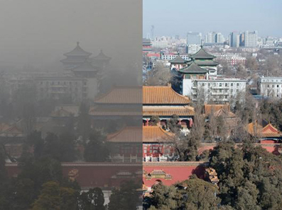
We live in an era of environmental deterioration through depletion and degradation of resources such as air, water, and soil; the destruction of ecosystems and the extinction of wildlife (Kondratyev, 1998; Kondratyev et al., 2004; Cracknell et al., 2009; Hansen et al., 2013; Freedman, 2014). As a matter of fact, environmental degradation is one of three main threats identified in 2004 by the High Level Threat Panel of the United Nations, the other two being poverty and infectious diseases. In particular, air pollution ranked seventh on the worldwide list of risk factors, contributing to approximately three million deaths each year. Air pollution is especially considerable in growing and emerging economies (Ramanathan and Feng, 2009; Rao et al., 2013) (see, for instance, Figure 1). Therefore, environmental studies are of great importance and they stand at the forefront of modern science (http://www.ipcc.ch/). Environmental research is a multi-disciplinary science because it comprises various branches of studies like chemistry, physics, medical science, life science, agriculture, public health, sanitary engineering, etc.

Figure 1. The pollution in Beijing (www.marketplace.org).
Environmental informatics is an integrator of science, methods and techniques for serving environmental engineering needs. It provides the information processing and communication infrastructure to the interdisciplinary field of environmental sciences aiming at data, information, and knowledge integration, the application of computational intelligence to environmental data as well as the identification of environmental impacts of information technology. The important tasks of the environmental informatics are the data interpretation, their collection, storage, processing, and display (Hilty et al., 1995).
One important area of environmental informatics is the acquisition of data related to remote sensing of atmosphere, vegetation, and ocean using optical, thermal infrared and microwave instruments (ground/ship-based, airborne, and satellite). Satellite remote sensing is of particular importance (Burrows et al., 2011). Environmental problems being global need global observation systems, which can only be achieved by using observations from satellite platforms. A great number of instruments have been installed on satellite platforms since satellite technology begun with the launch of Sputnik in 1957. They enable a much better understanding of the patterns of global atmospheric pollution by aerosol particles and also by various trace gases, land use, etc.
Despite significant scientific progress in the last decade, many domains of uncertainty still remain. In particular, the methods for the estimation of aerosol load using space-borne instrumentation must be greatly improved using multi-angular spectropolarimetry. The algorithms for the current spectrometers and radiometers require a number of a priori assumptions, which could potentially bias retrievals and lead to the underestimation (or overestimation) of the aerosol impact on the environment and climate.
Considerable improvement of the methods for the determination of atmospheric pollution from space is needed (Kokhanovsky and de Leeuw, 2009). The influence of trace gases, aerosol, and especially clouds (including polluted ice and water clouds) on the weather and climate requires more thorough studies based on the analysis of a large volume of data. Here, environmental informatics plays an important role. Mathematical methods must also be further improved for the solution of inverse problems (Rodgers, 2000), systems modeling, and optimization. The new approaches should be developed. Computer graphics and visualization for environmental decision support must be used on a far larger scale. It is anticipated that further developments will lead to the creation of better tools for environmental monitoring and control using both ground and satellite observation systems. This will enable more thorough decision and risk analysis for the environmental management (Gunderson and Holling, 2002; Folke et al., 2005).
References
Burrows, J. P., Platt, U., and Borrell, P. (2011). The Remote Sensing of Atmospheric Composition from Space. Berlin: Springer. doi: 10.1007/978-3-642-14791-3
Cracknell, A. P., Krapivin, V. F., and Varotsos, C. A. (2009). Global Climatology and Ecodynamics. Berlin: Praxis-Springer. doi: 10.1007/978-3-540-78209-4
Folke, C., Hahn, T., Olsson, P., and Norberg, J. (2005). Adaptive governance of social-ecological systems. Annu. Rev. Environ. Resour. 30, 441–473. doi: 10.1146/annurev.energy.30.050504.144511
Gunderson, L. H., and Holling, C. S. (eds.). (2002). Panarchy Synopsis: Understanding Transformations in Human and Natural Systems. Washington, DC: Island Press.
Hansen, J., Kharecha, P., Sato, M., Masson-Delmotte, V., Ackerman, F., Beerling, D. J., et al. (2013). Assessing “Dangerous Climate Change”: required reduction of carbon emissions to protect young people, future generations and nature. PLoS ONE 8:e81648. doi: 10.1371/journal.pone.0081648
Hilty, L. M., Page, B., Radermacher, F. J., and Riekert, W.-F. (1995). “Environmental Informatics as a new discipline of applied computer science,” in Environmental Informatics, eds N. M. Avouris and B. Page (Amsterdam: Kluwer Academic Publishers), 1–11.
Kokhanovsky, A. A., and de Leeuw, G. (eds.). (2009). Satellite Aerosol Remote Sensing Over Land. Berlin: Springer-Praxis. doi: 10.1007/978-3-540-69397-0
Kondratyev, K. Y., Krapivin, V. F., Savinykh, V. P., and Varotsos, C. A. (2004). Global Ecodynamics: A Multidimensional Analysis. Chichester: Springer/PRAXIS, 658.
Ramanathan, V., and Feng, Y. (2009). Air pollution, greenhouse gases, and climate change: global and regional perspectives. Atmos. Environ. 43, 37–50. doi: 10.1177/0734242X09350787
Keywords: environment, information technology, remote sensing, aerosol, trace gases
Citation: Kokhanovsky A (2014) Grand challenges in environmental informatics. Front. Environ. Sci. 1:5. doi: 10.3389/fenvs.2013.00005
Received: 11 November 2013; Accepted: 23 December 2013;
Published online: 21 January 2014.
Edited by:
Marco Casazza, Università degli Studi di Torino, ItalyCopyright © 2014 Kokhanovsky. This is an open-access article distributed under the terms of the Creative Commons Attribution License (CC BY). The use, distribution or reproduction in other forums is permitted, provided the original author(s) or licensor are credited and that the original publication in this journal is cited, in accordance with accepted academic practice. No use, distribution or reproduction is permitted which does not comply with these terms.
*Correspondence: alexander.kokhanovsky@eumetsat.int
 Alexander Kokhanovsky