 Lisa Sonnenburg
95% of researchers rate our articles as excellent or good
Learn more about the work of our research integrity team to safeguard the quality of each article we publish.
Find out more
PERSPECTIVE article
Front. Environ. Archaeol. , 19 February 2025
Sec. Landscape and Geological Processes
Volume 4 - 2025 | https://doi.org/10.3389/fearc.2025.1513697
This article is part of the Research Topic Indigenous Maritime Archaeology View all articles
This paper is a brief overview of almost two decades worth of research by the author in submerged site archaeology in the Great Lakes basin. This short synopsis will discuss four different sites in and around three Great Lakes representing almost 10,000 years of human occupation. Each site will describe the technology used, the approach toward Indigenous engagement and a summary of results. Presented in chronological order, each project demonstrates the continual technological advancements and resulting reduction in costs associated with researching submerged archaeological sites. In conjunction with illustrating rapid technological change, these projects also show how increasing collaboration with Indigenous communities and integration of traditional knowledge, allow for a more robust interpretation of how humans used these now inundated landscapes over time.
Water-level fluctuations since the Last Glacial Maximum have both inundated and raised shorelines in inland water bodies and coastal areas. Many areas have “gaps” in the archaeological record that can be at least partially explained by inundation of these sites due to rising post-glacial water levels (O'Shea and Sonnenburg, 2015). Depending on how the landscape was inundated, preservation can be exceptional compared to terrestrial sites (Ford et al., 2020). The possibility of finding site types that have been destroyed by exposure to the elements and/or modern development is one of the reasons that submerged site archaeology has grown as a distinct line of research worldwide over the past few decades (e.g., Galili et al., 1993; Flemming, 2004; Bailey and Flemming, 2008; Benjamin et al., 2011; Ford, 2011; Evans et al., 2014; Amkreutz et al., 2022; Lemke, 2024a).
Underwater archaeology is historically associated with shipwrecks and diving (Garrison and Cook Hale, 2021). This perception is partially driven by personalities such as Jacques Cousteau, or by dramatic discoveries, such as the finding of the Titanic in 1985 by Robert Ballard. These projects often featured expensive, highly technically specialized equipment that far exceeded the knowledge, and often modest budgets of most archaeological researchers (O'Shea, 2021; Lemke et al., 2022). In addition, many shipwrecks have associated historical documentation that allows for more targeted searches and are much more visible on the submerged landscape than often ephemeral prehistoric archaeological sites (Bowens, 2009; Boyd, 2024). However, the last two decades have seen a rapid advancement in technologies such as side-scan sonar and remotely operated vehicles (ROVs), which are now becoming more accessible in terms of lower cost and ease of use (Westley and Mcneary, 2017; O'Shea, 2021). In conjunction with these technological innovations, submerged site archaeology has grown as a distinct sub-discipline of underwater archaeology. While submerged sites have received less media attention than shipwrecks, this research is now being recognized as providing important insights-and in some cases, overturn long-held assumptions about past human behavior (e.g., Fedje and Josenhans, 2000; Werz and Flemming, 2001; Halligan et al., 2016; O'Shea, 2021; Benjamin et al., 2023; Lemke, 2024a).
This transition of submerged site archaeology from a highly technological, expensive “niche” area of archaeology to a more accessible, publicly visible, and less costly sub-discipline is illustrated through four projects in and around three of the Great Lakes spanning almost 20 years (Figure 1). Each section will describe the nature of the research, what technology was used, and how the technology has changed with each subsequent project in chronological order. Approximate costs of equipment and software are included, converted into United States Dollars (USD), and include inflation costs in parentheses (U.S. Official Inflation Data, 2024). These activities also explore the changes in the use of traditional Indigenous knowledge, starting with limited use and engagement with communities, to moving toward building capacity for Indigenous communities to lead their own submerged site research.
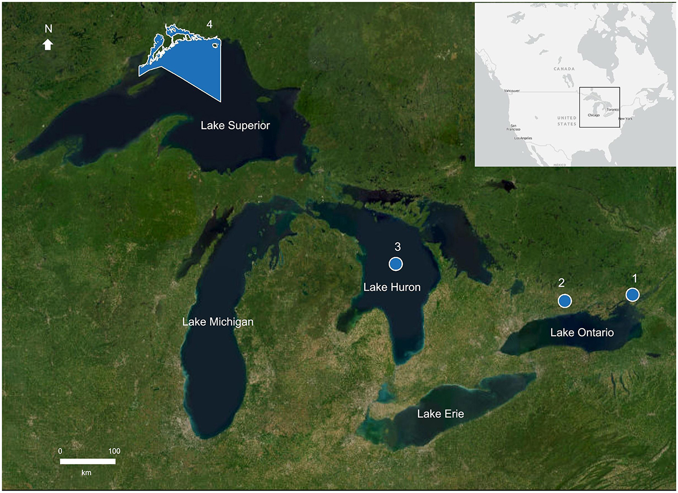
Figure 1. Locations of study areas within the Great Lakes Basin. 1-Colonel By Lake; 2-Rice Lake; 3-Lake Huron; 4-Lake Superior National Marine Conservation Area. Created by L. Sonnenburg (Parks Canada). Imagery from Earthstar Geographics (2024), 1:9,000,000.
Colonel By Lake was created in the 1830s because of the flooding of the Cataraqui River during construction of the Rideau Canal (Sonnenburg and Boyce, 2008). Like many anthropogenically-inundated landscapes, remnants of the original landscape and potential archaeological resources were likely preserved on the lake bottom. However, while the original maps and drawings completed during the construction of the canal were quite detailed, the accuracy of maps was less than ideal. As a result, the ability to “match” up the original landscape from these drawings with the modern landscape was almost impossible. The project used both single beam and side-scan sonar to map the bathymetry of the lake bottom and determine if there were any potential cultural resources still intact. These technologies use high-frequency acoustic beams either as a swath to provide a “picture” of dark and light areas (side-scan) or vertical “pings” that provide water depth information (single beam). The higher the frequency of the acoustic beams, the more detail the sonar can provide (National Oceanic Atmospheric Administration, 2024). The combination of these two technologies allowed for a digital bathymetric model that clearly showed the former path of the Cataraqui River, and the side-scan showed evidence of the remains of pre-canal dwellings that matched up well with the historical maps (Sonnenburg and Boyce, 2008; Supplementary Documentation, Slide 6).
The technology used to collect these data consisted of what was considered an “inexpensive” Knudsen 320BP echosounder with separate 200 kHz transducers for the single-beam and side-scan sonar mounted on a 4.5-meter aluminum boat (Sonnenburg and Boyce, 2008; Supplementary Documentation, Slide 5). As the transducers were the same frequencies, the data could not be collected concurrently. Geographic positions were collected with a separate Trimble differential geographic positioning system with an accuracy of < 1 meter. The geographic and sonar data required separate laptop computers, and downloading the data was often a long and painful process, requiring transfer to multiple floppy disks and then onto compact disks. Processing the data also required more advanced technical training to use two separate -and -expensive-software packages. We were fortunate enough that a local historian was willing to donate his vessel and boat operation skills to reduce our overall field costs, but the base cost of the equipment, computers and necessary software was ~$42,000 ($68,000).
Rice Lake, located ~90 km northeast of Toronto, has a record of human habitation of over 10,000 years. Like Colonel By Lake, it has seen changes in lake levels due to anthropogenic influences but also experienced climate-induced water-level fluctuations throughout the Holocene (Yu and McAndrews, 1994). This project intended to use similar methods to map the lake-bottom as in Colonel By Lake, but also included the extraction and analysis of sediment cores to better define water-level and environmental changes (Sonnenburg et al., 2013). These additional methods allowed for a more refined understanding of water-level fluctuations and submerged archaeological site potential in the study area, including the use of microdebitage as a submerged site indicator (Sonnenburg et al., 2011, 2012; Supplementary Documentation, Slides 7–11).
While this research initially used the same sonar system as in Colonel By, by 2008, consumer-grade sonar technology was rapidly advancing, with models like the Humminbird 778c. This unit cost under $3,500 ($5,000) and used a single transducer that could collect both side-scan and single beam sonar at the same time, as the side-scan was able to use a much higher frequency (475 kHz). The unit also came with its own positioning system with an accuracy of 3 to 5 meters. While not as accurate as the differential geographic positioning system, the built-in system was good enough for basic bathymetric mapping and eliminated the need for a separate laptop and hardware connection. Data were collected with a push of a button, and easily transferred to a secure digital (SD) card. Separate software was still needed to process the different sonar data types, but newly available open-source side-scan sonar mosaicking software (Sonarview 1.0; Young and Anstee, 2001) greatly reduced the time and expense of data processing.
In addition to the reduction in complexity and expense of data collection, the Rice Lake research also differed in its approach to engaging Indigenous communities. At Colonel By, there was no attempt at Indigenous engagement, mostly due to the misguided notion at the time by the author that as it was a “historic” site, there would be no need to approach local Indigenous communities. However, the research in Rice Lake would be directly adjacent to the Hiawatha and Alderville First Nations and ensuring that these communities were informed about the proposed research and invitations to participate were prioritized. While none of the communities that were contacted opted to be directly involved in the work, a copy of the completed thesis and collected data were sent to each community.
In the early 2000s, the National Oceanic and Atmospheric Administration published newly acquired, high-resolution (five-to-ten-meter contours) multibeam bathymetric maps of Lake Huron. These new data clearly showed an unbroken stretch of limestone, known as the Alpena-Amberley Ridge that connected the Canadian and American sides of Lake Huron. This piqued the interest of John O'Shea from the University of Michigan, who realized the ridge would likely have been above water during the Lake Stanley lowstand period between 10,000 and 8,000 years ago. In 2008, he collected side-scan imagery from the ridge that showed structures that bore a distinct resemblance to caribou hunting drive lines commonly used in the Arctic (O'Shea and Meadows, 2009). Over 15 years later, several of these drive lanes and hunting structure complexes have been located, mapped, and sampled, providing a detailed picture of early human activity in the Great Lakes (O'Shea et al., 2014, 2021).
When I joined the project in 2011, one of the unique aspects of the research was the use of a small, hand deployed ROV to investigate potential submerged structure locations prior to diver survey. The use of the ROV allowed for better planning for diver surveys, making efficient use of the limited time for dive operations due to depth (around 30 m) and water temperature (normally anywhere from two to four degrees Celsius). The ROV also provided an extra layer of diver safety, as the topside crew could view the dive survey and prepare in the event of an emergency ascension (Supplementary Documentation, Slide 13).
This was my first experience using an ROV. Like many people, my only knowledge of ROVs were the large, expensive ocean-going submersibles like the ones used to find the wreckage of the Titanic. The Outland ROV-1000, or “Jake,” as the ROV was christened, could be deployed by a single person, and was purchased second hand for about $50,000 ($73,000). The console for the ROV operation did require a power source and a stable surface, and the camera at the time did not record high-definition (HD) images. Although it was relatively easy to set up and use, becoming good at maneuvering it required much better hand-eye coordination than I possessed at the time.
Another unique aspect of this project the creation of a virtual world combining computer modeling of group behavior and ecological data. This “serious game” (one designed for a purpose other than entertainment) created a three-dimensional world to visually model caribou behavior and predict locations of submerged sites on the Alpena-Amberley Ridge (Fogarty et al., 2015). Robert Reynolds and his students at Wayne State University were able to continually integrate environmental and archaeological data as they were collected (Palazzolo et al., 2021). However, it was recognized that traditional ecological knowledge was needed to enhance the robustness of the model. The researchers were invited to the Native Village of Kotzebue, Alaska, where traditional knowledge keepers were able to enter the pre-historic landscape in virtual reality and provide valuable insight into how they saw the landscape while hunting caribou (Supplementary Documentation, Slide 14)). In addition, they provided suggestions for improvement of the model, while also expressing interest in using the tool to share hunting knowledge to younger generations (Lemke, 2024b). Now, instead of just being the recipient or subject of research, this community has not only become a true collaborator, but they will also be able to use this technology as new means of sharing their cultural traditions within their community.
Lake Superior National Marine Conservation Area (LSNMCA) consists of over 10,000 square kilometers of water and 600 islands along the north shore of Lake Superior. Administered by Parks Canada, its mandate is to protect and present Canada's natural and cultural heritage, while managing these resources in an ecologically sustainable manner (Parks Canada, 2016). As part of the Interim Management Plan for LSNMCA, a digital inventory of cultural heritage resources on land and under water has been established and requires continual updating to develop strategies to identify and protect these resources (Parks Canada, 2016). The challenge in meeting these goals is that the area is large and existing cultural resource data are sparse, particularly for submerged cultural resources that are not shipwrecks. While Parks Canada has an expert underwater archaeology team, there is a limited amount of time they can dedicate to a single area, and Lake Superior has a short operational season for diver survey. There is also a lack of high-resolution bathymetric data for most of LSNMCA, which prevents detailed predictive models or other desktop exercises from providing a foundation for the study of submerged cultural resources that have been successfully developed in Europe (Bailey and Flemming, 2008) or even the small-scale nested research strategy developed for the Alpena Amberley Ridge (O'Shea, 2021).
While collecting high-resolution multibeam sonar for the entire site was not feasible, the advances in consumer grade single beam and side-scan sonar technology that were initially used in Rice Lake meant that vessels currently used for field work and other operational activities in LSNMCA are equipped with these units. This allows for the collection of single beam and side-scan sonar data using a Humminbird Helix 12x MSI + GPS 4GN unit from a 5.5 meter- aluminum hulled vessel during operations outside of cultural resource management activities. These units now collect even higher resolution side-scan sonar data at up to 800 kHz. On the data processing side, easy-to-use, dependable, and inexpensive ReefMaster 2.0 software ($200) is available that quickly process both the single beam and side-scan sonar data and export the processed data into multiple geospatial and visual formats.
Another solution to expand our ability to detect submerged cultural resources was to invest in an ROV. As early as 2017, site staff had recommended the purchase of a Triton ROV for under $3,500 ($4,500). However, the purchase was never completed, and the company stopped producing and supporting this unit in 2020. Fortunately, by 2021, there were more companies that had developed similar portable, inexpensive ROVs and a purchase of one of these units was made early that year (Supplementary Documentation, Slides 15, 16).
In addition to weighing under 5 kg, having 4k resolution video and costing under $2,000 ($2,300), the FiFish V6 ROV was remarkably easy to set up and use, allowing for multiple staff to be trained quickly for ROV operations. The unit had the additional benefit of having a free app that could be downloaded to any portable device to operate the ROV. Not only did this allow for flexibility for individual ROV operators to use a device they were familiar and comfortable with, but it also allowed for viewing on multiple devices simultaneously. As a result, a new visitor experience program was developed around the ROV, providing the public access to Lake Superior's underwater history that had previously only been available to a small group of scientists, archaeologists, and divers. The “Underwater Museum” program deployed the FiFish V6 from a dock along the Nipigon waterfront to view the remains of a small wooden vessel. Visitors were provided with additional viewing devices that allowed them to “see” what the ROV was seeing in real time (Eckert and Giffin, 2022).
Finally, part of our work has expanded into building technological capacity for Indigenous communities and organizations, including Nokiiwin Tribal Council and the Red Rock Indian Band by providing microgrants to acquire their own ROVs, along with training on its operation and use. While the initial use of ROVs for these communities is to support environmental monitoring programs and inspect submerged infrastructure, there will also be opportunities for community-led stewardship of submerged cultural resources within their traditional territories. The hope is in the future, these communities will not just be collaborators in submerged site archaeological research but will be leading it.
With the rapid advancements in technology as illustrated by these four projects over two decades, it can be reasonably assumed that the next two decades will see a further reduction in cost and complexity of existing tools. For example, the side-scan sonar system used in 2005 was a 200 kHz system that required months to learn how to use and process the data. In 2023, I collected 800 kHz side-scan data on a unit that could be purchased at most outdoor retailers and took only a few days to learn the software and process the data. We are seeing rapid reductions in the cost of virtual reality systems, with consumer units such as the Meta Quest 3 currently retailing for $500, allowing for a wide variety of uses from medical treatments to music education (Yu and Guo, 2024; Safian et al., 2024). Open-source software for three-dimensional documentation and presentation of cultural heritage such as Sketch Fab (Corns et al., 2024) and PotreeJS (Gaspari et al., 2024) has become easier to use and highly sophisticated. Many existing technologies are also leveraging artificial intelligence (AI) capabilities to refine imagery and adjust position to target specific areas of interest (Chaithra et al., 2024). The ROVs in use at LSNMCA (Supplementary Documentation, Slide 15) had recent software updates that include the use of AI to automatically adjust their camera settings for changes in light and visibility without needing input from the operator.
These technological advancements of past, present and (probable) future, highlight the increasing democratization of science in general, and submerged site archaeology is a striking example. Once the realm of well-funded industrial salvage or research projects, or by highly specialized dive teams, investigations of submerged archaeological sites can now be done with equipment ordered with a credit card and operated by a smart phone. However, as with all advances in technology, there are both challenges and opportunities.
While the reduction in cost, size, and complexity of ROV operations has been beneficial to sites like LSNMCA and local Indigenous communities, it also allows less responsible users access areas that were previously considered “safe” from anthropogenic impacts. Underwater resources have always been at risk of disturbance from diver activity, but there has been a long history of underwater archaeologists collaborating with recreational divers (Flatman, 2007) with organizations like the Nautical Archaeological Society instrumental in providing training and collaborative opportunities (Bowens, 2009). However, these small ROVs can go much deeper than all but the most experienced technical divers, with most models able to reach a depth of 100 meters. Unlike SCUBA divers and airborne drone operators, small ROVs have few regulations or certification standards. In conjunction with easy-to-use sonar technology that is common on many small vessels, ROVs could allow for increased opportunities for the illegal removal of cultural resources in submerged contexts.
However, the same issues that may provide challenges for those trying to protect submerged cultural resources also provides opportunities for enhanced efforts and collaborations. Citizen science and community led archaeological projects for coastal and underwater archaeological have been implemented successfully worldwide (Scott-Ireton et al., 2023). The advancements discussed in this paper will only enhance these programs in the future. Finally, these technologies can continue to drive collaborations between researchers, government agencies and Indigenous communities, while also providing the tools for Indigenous-led submerged cultural resource stewardship in the future.
The original contributions presented in the study are included in the article/Supplementary material, further inquiries can be directed to the corresponding author.
LS: Writing – original draft, Writing – review & editing.
The author(s) declare financial support was received for the research, authorship, and/or publication of this article. Funding was provided by the Natural Sciences and Engineering Council of Canada to Joe Boyce for the Colonel By and Rice Lake projects. Funding for the Alpena-Amberley Ridge research was provided to John O'Shea by the National Science Foundation (NSF awards numbers BCS 0829324, 0964424, 1441241, and 1530628) and the National Atmospheric and Oceanic Administration (NOAA Ocean Exploration award NA10OAR0110187), and to the author by the Social Sciences and Humanities Research Council of Canada. LSNMCA projects are funded by Parks Canada.
The author would like to acknowledge the many people who supervised, funded, and assisted in numerous ways for all the projects mentioned in this article- Joe Boyce, Ken Watson, Jonathan Moore, Jill Krezoski, Ed Reinhardt, Sunset Cove Resort, Hiawatha and Alderville First Nations, Phil Suttak, John O'Shea, Ashley Lemke, Pro-Com Diving, Parks Canada, Nokiiwin Tribal Council, Red Rock Indian Band, Lisa Nyman, Michael Gemmell and Liam Giffin. Details of these projects can be found in previous publications that are cited in the article and included in the references.
The author declares that the research was conducted in the absence of any commercial or financial relationships that could be construed as a potential conflict of interest.
The author(s) declare that no Gen AI was used in the creation of this manuscript.
All claims expressed in this article are solely those of the authors and do not necessarily represent those of their affiliated organizations, or those of the publisher, the editors and the reviewers. Any product that may be evaluated in this article, or claim that may be made by its manufacturer, is not guaranteed or endorsed by the publisher.
The Supplementary Material for this article can be found online at: https://www.frontiersin.org/articles/10.3389/fearc.2025.1513697/full#supplementary-material
Amkreutz, L., and van der Vaart-Verschoof, S. eds. (2022). Doggerland: Lost World Under the North Sea. Leiden: Sidestone Press
Bailey, G. N., and Flemming, N. C. (2008). Archaeology of the continental shelf: marine resources, submerged landscapes and underwater archaeology. Quat. Sci. Rev. 27, 2153–2165. doi: 10.1016/j.quascirev.2008.08.012
Benjamin, J., Bonsall, C., Pickard, C., and Fischer, A. eds. (2011). Submerged Prehistory. Oxford: Oxbow.
Benjamin, J., O'Leary, M., McCarthy, J., Reynen, W., Wiseman, C., Leach, J., et al. (2023). Stone artefacts on the seabed at a submerged freshwater spring confirm a drowned cultural landscape in Murujuga, Western Australia. Quat. Sci. Rev. 313:108190. doi: 10.1016/j.quascirev.2023.108190
Bowens, A. ed. (2009). Underwater Archaeology: The NAS Guide to Principles and Practice 2nd edition. Malden: Blackwell Publishing.
Boyd, M. (2024). Coastal archaeological site visibility problems and underwater prospects in the Northern Lake Superior Basin. Geoarchaeology 39, 3–16. doi: 10.1002/gea.21979
Chaithra, N., Jha, J., Sayak, A., Priya, M. A., Allagari, N., Chandana, K., et al. (2024). “Enhancing Underwater Imagery with AI/ML and IoT in ROV Technology,” in Artificial Intelligence and Edge Computing for Sustainable Ocean Health, eds. D. De, D. Sengupta, and T. Tran (Cham, Switzerland: Springer), 311–342. doi: 10.1007/978-3-031-64642-3_14
Corns, A., Davidson, L., Namberi, S., O'Reilly, R., and Shaw, R. (2024). Developing enhanced and enriched 3D models of cultural heritage assets as part of the EU co-funded 5DCulture project. Int. Arch. Photogramm. Remote Sens. Spatial Inf. Sci, XLVIII-2/W4-2024, 157–164. doi: 10.5194/isprs-archives-XLVIII-2-W4-2024-157-2024
Eckert, N., and Giffin, L. (2022). Underwater Museum. Parks Canada. Avaialable at: https://parks.canada.ca/amnc-nmca/on/super/info/bulletin/55 (accessed October 16, 2024).
Evans, A., Flatman, J. C., and Flemming, N. C. eds. (2014). Prehistoric Archaeology of the Continental Shelf: A Global Review. New York: Springer.
Fedje, D. W., and Josenhans, H. (2000). Drowned forests and archaeology on the continental shelf of British Columbia, Canada. Geology. 28, 99–102. doi: 10.1130/0091-7613(2000)28%3C99:DFAAOT%3E2.0.CO;2
Flatman, J. (2007). The origin and ethics of maritime archaeology—part 1. Public Archaeol. 6, 77–97. doi: 10.1179/175355307X230739
Flemming, N. C. ed. (2004). Submarine Prehistoric Archaeology of the North Sea: Research Priorities and Collaboration with Industry. York: Council for British Archaeology.
Fogarty, J., Reynolds, R. G., Salaymeh, A., and Palazzolo, T. (2015). “Serious game modeling of caribou behavior across lake huron using cultural algorithms and influence maps,” in Caribou Hunting in the Upper Great Lakes: Archaeological, Ethnographic and Paleoenvironmental Perspectives, eds. E. Sonnenburg, A. K. Lemke, J. M. O'Shea. (Ann Arbor, MI: University of Michigan), 31–49.
Ford, B., Halligan, J. J., and Catsambis, A. (2020). Our Blue Planet: An Introduction to Maritime and Underwater Archaeology. New York: Oxford University Press.
Galili, E., Weinstien-Evron, M., Hershkovitz, I., Gopher, A., Kislev, M., Lernau, O., et al. (1993). Atlit-Yam: a prehistoric site on the sea floor off the Israeli coast. J. Field Archaeol. 20, 133–157. doi: 10.1179/jfa.1993.20.2.133
Garrison, E. G., and Cook Hale, J. W. (2021). “The early days” – underwater prehistoric archaeology in the USA and Canada. J. Isl. Coast. Archaeol. 16, 27–45. doi: 10.1080/15564894.2020.1783399
Gaspari, F., Barbieri, F., Fascia, R., Ioli, F., and Pinto, L. (2024). An open-source web platform for 3D documentation and storytelling of hidden cultural heritage. Heritage 7, 517–536. doi: 10.3390/heritage7020025
Halligan, J. J., Waters, M. R., Perrotti, A., Owens, I. J., Feinberg, J. M., Bourne, M. D., et al. (2016). Pre-clovis occupation 14,550 years ago at the Page-Ladson site, Florida, and the peopling of the Americas. Sci. Adv. 2, 1–8. doi: 10.1126/sciadv.1600375
Lemke, A. (2024b). Anthropology underwater: investigating hunter-gatherer responses to Holocene water levels through archaeology, indigenous partnerships, and virtual reality. Hunter Gather. Res. 8, 1–24. doi: 10.3828/hgr.2024.11
Lemke, A., Grinnan, N. B., and Haigler, J. V. (2022). Getting your feet wet: barriers to inclusivity in underwater archaeology and how to break them. Adv. Archaeol. Pract. 10, 129–139. doi: 10.1017/aap.2021.34
National Oceanic and Atmospheric Administration (2024). Side-Scan Sonar. Available at: https://oceanexplorer.noaa.gov/technology/sonar/side-scan.html (accessed December 13, 2024).
O'Shea, J. (2021). Submerged prehistory in the Americas: methods, approaches, and results. J. Isl. Coast. Archaeol. 16, 1–4. doi: 10.1080/15564894.2021.1879973
O'Shea, J. M., Lemke, A. K., Nash, B. S., Sonnenburg, E. P., Ferguson, J. R., Nyers, A. J., et al. (2021). Central oregon obsidian from a submerged early holocene archaeological site beneath Lake Huron. PLoS ONE 16:e0250840. doi: 10.1371/journal.pone.0250840
O'Shea, J. M., Lemke, A. K., Sonnenburg, E. P., and Abbott, B. D. (2014). A 9,000-year-old caribou hunting structure beneath Lake Huron. Proc. Natl. Acad. Sci. 111, 6911–6915. doi: 10.1073/pnas.1404404111
O'Shea, J. M., and Meadows, G. A. (2009). Evidence for early hunters beneath the Great Lakes. Proc. Natl. Acad. Sci. 106, 10120–10123. doi: 10.1073/pnas.0902785106
O'Shea, J. M., and Sonnenburg, E. (2015). “Introduction to Lake Stanley archaeology in the Lake Huron basin,” in Caribou Hunting in the Upper Great Lakes: Archaeological, Ethnographic and Paleoenvironmental Perspectives, eds. E. Sonnenburg, A. K. Lemke, J. M. O'Shea. (Ann Arbor, MI: University of Michigan), 1–4.
Palazzolo, T., Lemke, A., Zhang, C., Saad, S., Reynolds, R. G., and O'Shea, J. (2021). “DeepDive: the use of virtual worlds to create an ethnography of an ancient civilization”, in HCI International 2021—Late Breaking Papers: Cognition, Inclusion, Learning, and Culture, eds. C. Stephandis, et al. (Cham, Switzerland: Springer), 615–629.
Parks Canada (2016). Lake Superior National Marine Conservation Area of Canada Interim Management Plan. Available at: https://parks.canada.ca/amnc-nmca/on/super/info/index/gestion-management-2016 (accessed October 15, 2024).
Safian, A. R., Saidon, Z. L., Nasrifan, M. N., Djahwasi, H. R., Sampurno, M. B. T., Nikko Mazlan, C. A. N., et al. (2024). Design and development of e-MARZ: a practical guide to implementing cost-effective VR experiences for music education. J. Adv. Res. Appl. Sci. Eng. Technol. 40, 129–145. doi: 10.37934/araset.40.1.129145
Scott-Ireton, D. A., Jones, J. E., and Raupp, J. T. eds. (2023). Citizen Science in Maritime Archaeology. Gainsville: University Press of Florida.
Sonnenburg, E. P., and Boyce, J. I. (2008). Data-fused digital bathymetry and side-scan sonar as a base for archaeological inventory of submerged landscapes in the Rideau Canal, Ontario, Canada. Geoarchaeology 23, 654–674. doi: 10.1002/gea.20236
Sonnenburg, E. P., Boyce, J. I., and Reinhardt, E. G. (2011). Quartz flakes in lakes: microdebitage evidence for submerged Great Lake prehistoric (Late Paleoindian-Early Archaic) tool-making sites. Geology 39. 631–634. doi: 10.1130/G31964.1
Sonnenburg, E. P., Boyce, J. I., and Reinhardt, E. G. (2013). Multi-proxy lake sediment record of prehistoric (Paleoindian-Archaic) archaeological paleoenvironments at Rice Lake, Ontario, Canada. Quat. Sci. Rev. 73, 77–92. doi: 10.1016/j.quascirev.2013.05.012
Sonnenburg, E. P., Boyce, J. I., and Suttak, P. (2012). Holocene paleoshorelines, water levels and submerged prehistoric site potential of Rice Lake (Ontario, Canada). J. Archaeol. Sci. 39, 3553–3567. doi: 10.1016/j.jas.2012.05.035
U.S. Official Inflation Data, Alioth Finance. (2024). Inflation Calculator. Available at: https://www.officialdata.org/us/inflation/ (accessed December 13, 2024).
Werz, B. E. J. S., and Flemming, N. C. (2001). Discovery in table bay of the oldest handaxes yet found underwater demonstrates preservation of hominid artefacts on the continental shelf. S. Afr. J. Sci. 97, 183–185. Available at: https://hdl.handle.net/10520/EJC97332
Westley, K., and Mcneary, R. (2017). Archaeological applications of low-cost integrated sidescan sonar/single-beam echosounder systems in Irish Inland waterways. Archaeol. Prospection. 24. 37–57. doi: 10.1002/arp.1551
Young, A., and Anstee, S. (2001). A User's Guide to Sonarview 1.0: A Sidescan Sonar Post-Processing System. Victoria: DSTO Aeronautical and Maritime Research Laboratory.
Yu, Z., and Guo, S. (2024). A low-cost, wireless, 4-channel EEG measurement system used in virtual reality environments. Hardware X 17:e00507. doi: 10.1016/j.ohx.2024.e00507
Keywords: submerged site archaeology, Great Lakes, paleoenvironments, remotely operated vehicles, technology
Citation: Sonnenburg L (2025) Research in Great Lakes submerged site archaeology: past, present and future. Front. Environ. Archaeol. 4:1513697. doi: 10.3389/fearc.2025.1513697
Received: 18 October 2024; Accepted: 03 February 2025;
Published: 19 February 2025.
Edited by:
Meaghan Efford, University of British Columbia, CanadaReviewed by:
Aron L. Crowell, Smithsonian National Museum of Natural History (SI), United StatesCopyright © 2025 Sonnenburg. This is an open-access article distributed under the terms of the Creative Commons Attribution License (CC BY). The use, distribution or reproduction in other forums is permitted, provided the original author(s) and the copyright owner(s) are credited and that the original publication in this journal is cited, in accordance with accepted academic practice. No use, distribution or reproduction is permitted which does not comply with these terms.
*Correspondence: Lisa Sonnenburg, bGlzYS5zb25uZW5idXJnQHBjLmdjLmNh
Disclaimer: All claims expressed in this article are solely those of the authors and do not necessarily represent those of their affiliated organizations, or those of the publisher, the editors and the reviewers. Any product that may be evaluated in this article or claim that may be made by its manufacturer is not guaranteed or endorsed by the publisher.
Research integrity at Frontiers
Learn more about the work of our research integrity team to safeguard the quality of each article we publish.