 Valeria Franco Salvi
 Jordi A. López Lillo
 Julián Salazar
94% of researchers rate our articles as excellent or good
Learn more about the work of our research integrity team to safeguard the quality of each article we publish.
Find out more
ORIGINAL RESEARCH article
Front. Environ. Archaeol., 20 February 2025
Sec. Landscape and Geological Processes
Volume 4 - 2025 | https://doi.org/10.3389/fearc.2025.1453746
This article is part of the Research TopicNew Theoretical and Methodological Approaches to Land Use Dynamics in the Andes during the Late HoloceneView all 8 articles
This study examines the agricultural and ecological strategies of pre-Hispanic Andean communities, focusing on their innovative practices and land management techniques that fostered complex agrarian systems. It highlights early village settlements in northwestern Argentina, where households thrived for centuries by leveraging local knowledge deeply intertwined with rituals. The research reveals a flexible agricultural system that flourished in the studied valleys, supported by sophisticated social dynamics and advanced agrarian infrastructure. These communities adapted to challenges like uneven terrain, limited water access, and harsh high-altitude climates through a profound understanding of ecology and natural phenomena. The social structure, characterized by autonomous domestic units without centralized hierarchies, enabled efficient management of agricultural plots based on familial knowledge. This autonomy also facilitated coordinated activities like herding and post-harvest maintenance, ultimately enhancing agricultural productivity. The article concludes by emphasizing that applying ancient practices to contemporary sustainability challenges requires a deep understanding of specific cultural and environmental contexts. Rather than relying on generic solutions, it is essential to clearly define and thoroughly study these contexts to ensure their effectiveness and relevance.
This paper focuses on the development of farming practices in early village landscapes, using data from one of the earliest settlements in Northwestern Argentina (NWA), dating from 300 BCE to 950 CE. The main objective is to characterize the agrarian landscape, identify the social structures that managed it, and develop a comprehensive framework for understanding the agricultural system. Our working hypothesis is that the techniques used in these valleys thrived in contexts where autonomous households existed, with low inequality and no centralization of power. This decentralized approach allowed the communities to endure for centuries, with small, self-sufficient groups independently managing farming activities and making decisions guided by local knowledge and the specific needs of their environment. These practices were closely linked to rituals and ceremonies, such as offerings and the strategic placement of menhirs, which were integral to the agrarian cycle. Due to their autonomy, households were able to sustain agricultural practices over long periods, however, during the climate shift at the end of the millennium, the lack of coordination and inter-community networks prevented a collective response, limiting resilience to the increasing aridity.
In the long term, we aim to explore whether it is feasible to integrate ancestral agricultural techniques into modern practices and whether current political conditions pose a limitation or an opportunity for such integration. While contemporary literature often proposes these ancestral practices as solutions to current agricultural challenges, replicating these methods is not straightforward. For these techniques to be effective today, it is essential to consider the significant differences between the political, social, and economic contexts of the past and those of the present, which are marked by centralized power, growing social inequalities, and the globalization of modern production systems—factors that present considerable obstacles to their implementation.
Northwestern Argentina (NWA) provides evidence of sophisticated agricultural and engineering practices that rendered farming landscapes productive and sustainable for millennia (Korstanje et al., 2015). Facing periods of drought, conflict, and conquest, these societies maintained agrarian landscapes that consistently supported large numbers of people, while their agricultural practices minimized labor and material investments, relying on a deep understanding of ecology and environmental dynamics to demonstrate their sustainability (Korstanje, 2005). Confronted with challenges such as rugged terrain, sporadic water access, and harsh climatic conditions, these populations implemented flexible strategies and infrastructure to enhance food production. This paper presents archaeological evidence to underscore the diverse material and sociotechnical advancements that sustained this agricultural system over an extended period (300 BCE and 950 CE).
Agriculture and livestock management were fundamental to ancient societies in the Southern Andes (Olivera, 2001). Archaeological research into these activities offers new insights into the lifestyles of people from that era while enhancing our understanding of sustainable environmental practices that remain relevant today. In Argentina, an increasing number of projects view these landscapes as dynamic, historical, and multi-layered entities that shaped social transformations. As a result, systematic studies of terraces, corrals, and outdoor areas have uncovered complexities that challenge previous assumptions about the pre-Hispanic past (Franco Salvi, 2016).
Historically, Argentine archaeology has concentrated primarily on residential and burial sites, often overlooking comprehensive studies of cultivation and herding (Quesada, 2006). However, in recent years, there has been a notable shift, with scholars increasingly recognizing that these practices were not just related to subsistence but also played a vital role in social relationships (Hodder, 2014). This shift has led to a more nuanced understanding of the role agricultural fields played in daily life, the social bonds they nurtured, and the dynamics that shaped them. In contrast, the long-standing view that linked changes in agricultural practices and field design to external factors such as climate or contact with other societies is now being questioned (Ramundo, 2010). Fields are now recognized as spaces where farmers constructed identities, forged social bonds, and navigated tensions within a complex network of human and non-human interactions. This new approach has been driven by the work of Korstanje and Quesada (2010) in Argentina, along with other scholars from the Andes (Hastorf, 1993; Erickson, 2006), who argue that agriculture is not merely about physical survival but also about shaping memories, social ties, and cultural practices.
Pastoralism, agriculture, hunting, gathering, and non-market exchange were all integral parts of a diverse range of economic activities in these villages (Olivera, 2001). Here, perceived obstacles to production and development were transformed into opportunities, even in the face of challenging geography and environmental conditions. For instance, the mountainous terrain was ingeniously harnessed for crop cultivation and water distribution, while hilltops provided ideal locations for constructing herd pens (corrals) and managing livestock. Cold and dry periods were strategically utilized for soil maintenance, animal relocation, and the cultivation of lower-lying areas. Thus, these activities complemented one another, creating new opportunities grounded in established management practices (Olivera, 2001).
Indigenous communities in NWA exhibited remarkable expertise in terrace management, using sophisticated irrigation methods to evenly distribute water across varying elevations (Albeck, 2003). Furthermore, the southern Andes region hosted numerous pre-Hispanic societies that heavily relied on pastoralism as a fundamental economic and cultural practice (Yacobaccio, 2013, 2014). Domesticated llamas served a multifaceted role in these societies, providing valuable resources. They were essential for clothing production and meat supply, and they also played a pivotal role in facilitating exchange as a means of transportation (Maryañski and Nielsen, 2023).
Over the past two decades, a line of research has emerged in Argentina focused on understanding the role of agrarian landscapes and the material aspects of food production in archaeology (Albeck, 1993, 2000; Korstanje and deBabot, 2002; Korstanje, 2005; Korstanje et al., 2015; Lane, 2016; Maloberti, 2014; Quesada, 2006; Yacobaccio, 2014; Zuccarelli Freire et al., 2021; Zucol et al., 2012; Williams, 2015). These early advances provide a more comprehensive understanding of crop management and its diversity in pre-Hispanic times, emphasizing the need to explore agricultural landscapes to elucidate the intricate production strategies that underpinned these societies across different periods. Moreover, the demand for paradigmatic examples of sustainable crop practices is increasingly urgent in today's context, characterized by burgeoning complexities such as climate change, population growth, and poverty—especially in a region facing increasing poverty and declining household farming.
In 2007, archaeological investigations were launched at the Southern Cumbres Calchaquíes, primarily aimed at deepening our understanding of the political dynamics that shaped the first millennium CE. More precisely, the focus was directed toward analyzing the adoption of novel economic practices, including agriculture and animal husbandry, alongside the emergence of new technologies such as ceramics, lithics, hydraulics, and other innovations that supported these activities (Salazar et al., 2008). Archaeological efforts were conducted across various ecological zones of the Cumbres to advance diverse lines of research. Through 37 fieldwork campaigns, strong connections were established with the local Diaguita communities, who continue to inhabit the study area. This led to ongoing dissemination projects focused on claiming pre-Hispanic history, enhancing understanding of local archaeological findings, and preserving the region's cultural heritage. The combination of surveys, excavations, radiocarbon dating, and laboratory analyses has made this region one of the most thoroughly studied in Northwest Argentina regarding the Formative period, which is generally defined by the development of agropastoral societies, typically sedentary or with limited mobility, and characterized by the use of technologies such as ceramics, textiles, and metals (Núñez Regueiro, 1974), serving as a model for evaluating new paradigms related to social transformations between 300 BCE and 950 CE.
La Ciénega and Tafí valleys (Figure 1) stand as two pivotal areas crucial for comprehending these processes, nestled within the intermontane valleys of NWA. The altitudinal range of the basins, spanning from 1,800 to 4,000 m asl, categorizes them within the group of mesothermic valleys and ravines found in the Andean region, commonly referred to as “Keshua” in the Quechua language, which translates to “protected and cultivated valley” (Berberián and Raffino, 1991: 97). Within this elevation range, typically between 2,000 and 3,000 m asl, certain distinct climatic characteristics prevail, including elevated temperatures compared to higher altitudes, moderated diurnal and nocturnal temperature fluctuations, fewer occurrences of frost, and increased average precipitation levels (Martín et al., 2002).
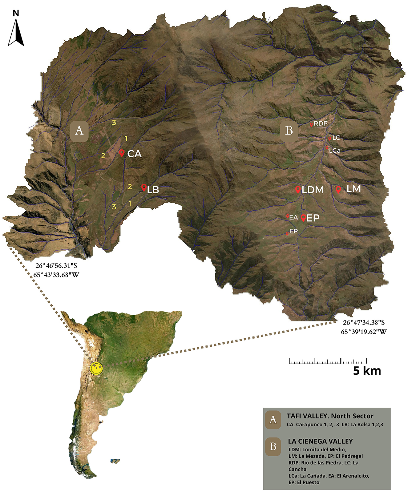
Figure 1. Study area: highlighting the northern sector of the Tafí and La Ciénega valleys.
Marked by an average annual temperature of 13.5°C and coupled with an annual potential evapotranspiration of 694.0 mm, they experience precipitation levels documented at 417.5 mm annually. A persistent water deficit affects the region year-round, except during November through March. Humidity levels fluctuate depending on factors such as altitude, slope orientation to the sun, and prevailing southeasterly winds. Additionally, the area experiences varied frost patterns, with the average first frost occurring on May 18 and the last frost on September 20 (Martín et al., 2002).
Pollen analysis provided valuable insights into the environmental and climatic conditions of the study areas, revealing a typical xerophytic flora dominated by taxa such as Asteraceae, Poaceae, Chenopodiaceae, and Cyperaceae (Grill et al., 2013). Temporal variations in vegetation communities indicate a transition from drier to wetter conditions. In several adjacent valleys (e.g., Santa María), phytolithic assemblages reveal significant climatic changes, indicating a period of humid and cold conditions from before the beginning of the Common Era to ~1,000 CE. This is followed by a transition to a warmer and drier climate, coinciding with the Medieval Warm Anomaly (Lefebvre et al., 2024). Additionally, Garalla (2003) notes that from ~190 BCE (±40 years) to 1,075 BCE (±20 years), the region exhibited herbaceous steppe vegetation with some shrub species under humid conditions. However, beginning around 1,150 ± 20 CE, there was a significant decline in extra-local pollen supply, leading to the establishment of vegetation typical of dry environments. This transition corresponds with the “Medieval Warm Anomaly” observed in the pre-Puna region of northwestern Argentina, occurring between 925 CE and 1,425 CE (Garalla, 2003). Together, these findings illustrate the dynamic climatic conditions that shaped the region's vegetation and influenced agricultural practices, particularly at the onset of the first millennium CE, when favorable conditions coincided with the establishment of various settlements (Sampietro and Sayago, 1998; Sampietro Vattuone, 2001).
During the first millennium CE in the valleys and broader region of the NWA, a series of social phenomena emerged, involving the organization of communal relations, which facilitated agreements for the care of agricultural and pastoral endeavors. Notably, in the southernmost areas of the Cumbres Calchaquíes, substantial permanent settlements emerged, characterized by a diverse array of habitation structures, agricultural and livestock facilities, as well as the adoption of innovative technologies like ceramics and lithics. Additionally, these settlements feature large carved sculptures, communal usage mounds, and milling areas. This change toward a village-centric lifestyle prompted a reconfiguration of social norms and interaction dynamics, alongside a broadening of resource bases and social reproduction (Salazar, 2010). The Tafí valley has been extensively studied, uncovering a history of remarkable agricultural prosperity. Various researchers, including Sampietro Vattuone (2002) and Manasse (2019), have identified structures across different areas of the Tafí valley attesting to large-scale agricultural activity. Additionally, studies by Roldan et al. (2005) and Roldán et al. (2009) have revealed that the alluvial soils of the paleosoil in these zones exhibited high concentrations of organic phosphorus, indicating their fertility. In summary, available evidence suggests that these valleys served as important centers for crop production among the populations inhabiting them in the past, highlighting the richness of their soils, the diversity of crops cultivated, and the implementation of agricultural zoning. These factors exemplify the complexity and richness of agriculture in this region (Berberián and Nielsen, 1988; Carrizo et al., 1999; Franco Salvi, 2016; Korstanje et al., 2015; Roldán et al., 2016; Scattolin, 2007). The favorable conditions during which these settlements developed, combined with the extensive land areas, alluvial fans, and piedmont conoids, facilitated the intensification of agriculture, primarily focusing on the cultivation of maize (Zea mays) and other crops such as tubers, pseudocereals, and pulses (Berberián and Raffino, 1991; Salazar, 2010).
The two archaeological sectors studied here -Tafí and La Ciénega-, both dating to the first millennium CE, are located near each other, separated by a natural border of hills that can be crossed on foot. With a maximum distance of 8 km between them, the trek connecting these sites typically requires about 6 h of walking. Both sectors contain materialities dated to the same period, including ceramics, lithic materials, and architectural structures. However, differences emerge in terms of agricultural activity, with La Ciénega exhibiting a lower presence of infrastructure related to farming, despite the similar environmental conditions in both areas. The radiocarbon dating indicates that the primary occupation of the region took place between 200 BCE and 850 CE. (Franco Salvi et al., 2014; Salazar et al., 2024). Concurrently, neighboring sites such as Carapunco, El Infiernillo, El Tolar, El Remate, and El Rincón exhibit surface structures and contexts that show remarkable similarities, as documented in various studies (Cremonte, 1988, 1996; Berberián and Nielsen, 1988; Sampietro Vattuone, 2002; Cuenya and García Azcárate, 2004; Oliszewski and Di Lullo, 2020).
The study of the agricultural and pastoral landscapes of the Cumbres Calchaquíes applied a multidisciplinary approach, integrating various methods. Spatial analysis was conducted through altimetric mapping of settlements, along with a functional analysis linking water management systems with agricultural and herding practices. To gain a deeper understanding of the context, we applied techniques from the physical, chemical, biological, and earth sciences to address key archaeological questions. Traditional archaeological methods, such as surveys and excavations, were also employed.
A thorough survey of archaeological evidence was carried out using large-scale analysis of aerial photographs. This research focused on several areas within the Tafí and La Ciénega valleys, where sites such as La Bolsa 1 (LB1), 2 (LB2), and 3 (LB3), Carapunco 1 (CA1), 2 (CA2), and 3 (CA3), as well as El Pedregal (EP), Río de las Piedras (RP), La Cancha (LC), La Cañada (LCa), La Mesada (LM), Lomita del Medio (LDM), El Arenalcito (EA), and El Puesto (EP) were examined (Figure 1). A detailed cartographic database was built using remote sensing techniques, incorporating high-resolution satellite imagery and aerial photography. These images were processed with WebODM photogrammetry software (OpenDroneMap1, WebODM, n.d), followed by georeferencing and orthorectification, resulting in high-resolution orthomosaics that provided detailed views of the sites.
The database (Supplementary Material A) encompassed much more than geospatial data, documenting various archaeological, historical, and contemporary elements. It included detailed information on agricultural production areas, crop fields, farmyards, landscape transformations, settlements, roads, and public spaces. Topographical surveys incorporated registration forms into a Geographic Information System (GIS), utilizing QGIS (version 3.16.14-Hannover) to generate maps and produce a digital elevation model (DEM) with a resolution of 4 meters and a vertical accuracy of 2 meters. In addition, archaeological features were documented using unmanned aerial vehicles (UAVs) and orthophotos. This comprehensive approach allowed for a thorough review of classification criteria and the integration of various topographical techniques. The primary records were made readily available for review, ensuring the optimal use of resources. Furthermore, quality control measures were implemented to enhance subsequent analyses after the digital model of the settlement was reconstructed (López Lillo, 2022).
The work process involved the documentation of archaeological structures using a variety of methodologies, based on the available resources. These methodologies included traditional topography supported by GPS (n = 229, 10.68%), UAV-derived orthophotos (n = 1,851, 86.34%), and satellite images from the Pléiades series (n = 64, 2.98%), all linked through a uniform system of registration cards. The integration of this information was carried out within the GIS environment; in the case of the traditional topography, structures were identified strictly through visual means, while the other methodologies relied on photointerpretation followed by ground verification in the field. Following this, the vectorization of the structures was completed, and the associated attribute tables recorded in the registration cards were imported into the system. The geolocation of the vectorized structures was then corrected on the Pléiades images to eliminate any potential relative errors accumulated across the various GPS and UAV series. It was also important to note that these same images served as the basis for the creation of the Digital Surface Model (DSM), which was used in subsequent analyses conducted by Airbus Defense and Space. These analyses were carried out across the entire Ciénega Valley, ensuring a comprehensive examination of the entire area.
A visibility evaluation was conducted to examine the spatial relationship and visual connections between residential and agricultural areas, based on the centroids of central courtyards for domestic units and the non-roofed polygons for productive units, which were selected as key reference points for assessing visibility within the landscape. Using the QGIS visibility analysis plugin (Cučković, 2016), a reference height of 1.60 meters was established to calculate two main parameters: the visibility index over the elevation 4 DSM and the cumulative visibility basin for the domestic units. Raster data were extracted at these reference points to calculate values representing both the overall prominence within the valley and the relative prominence of each structure's inhabited space. These values were incorporated into the attribute tables for further analysis.
Although a comprehensive vegetation survey of the La Ciénega valley has not yet been conducted, preliminary estimates were made using Sentinel-2 multispectral imagery captured throughout the 2019 vegetation cycle. To reduce the effect of bare soil on the results, the Soil-Adjusted Vegetation Index (SAVI) was applied instead of the standard NDVI (Huete, 1988), as SAVI is less sensitive to distortions caused by exposed ground. Multitemporal composites of these maps were created and compared with variations in shortwave infrared (SWIR) bands to identify regions with higher moisture content throughout the year. The digital settlement model played a crucial role in integrating various spatial data layers within a GIS environment, enabling the analysis of the structural characteristics of human settlements. These layers included vectorized archaeological structures, DSM elevation data, and supplementary information derived from these sources, such as orientation and slope maps. To analyze the catchment areas (SCA) around each dwelling, we used the GRASS 7 algorithms integrated within QGIS to generate an anisotropic displacement cost map, expressed in time, for each of the 129 centroids of the central courtyards. The DSM served as the foundation for these calculations.
Fieldwork involved validating satellite imagery data through archaeological surveys across various regions, with a focus on cultivation areas and other features related to agricultural and pastoral production. Additionally, detailed mapping of slopes, watersheds, micro-watersheds, drainage networks, and catchment areas was carried out. Random and directed sampling methods were used to detect agrarian structures and parcels, as well as to identify and date archaeological contexts at each site.
Micromorphological and physicochemical soil analyses were used to identify the formation processes of the agro-pastoral spaces and to assess human impact on local soils. Excavations followed natural stratigraphy, providing a detailed three-dimensional record of collapsed rocks, features, archaeological materials, and evidence of post-depositional alterations. This information was compiled into a georeferenced AutoCAD file, which proved essential for identifying construction events, activity areas, and practices related to maintenance, abandonment, and reoccupation. All strata, features, and interfaces were classified as stratigraphic units (SUs) and represented in a diagrammatic format (Harris, 1991; Carandini, 1997). This process enabled the development of a biographical sequence detailing the structures from their initial construction to our intervention.
It is crucial to highlight that within the agricultural strata, two temporal dimensions coexist in forming the record: discrete events that yield specific material traces and recurring events that produce an “averaged” record (Salazar, 2010). To analyze these dimensions, the methodology proposed by Harris (1991) was adopted, involving the graphic representation of stratigraphic succession in the form of a matrix (Harris Matrix). This approach has also been utilized by Carandini (1997) for the chronological interpretation of architectural structures. Moreover, a total of 20 1 × 1 m test pits were conducted, producing ~100 samples for laboratory analysis, as well as 20 radiocarbon dates (Franco Salvi et al., 2014; Salazar et al., 2024).
The analytical framework also encompassed archaeobotanical studies, which identified the plant taxa cultivated in agrarian regions and provided valuable insights into past agricultural practices. Additionally, the properties of phytoliths were examined in detail, contributing to a deeper understanding of the plant materials used throughout the region's history (Piperno, 2006). Sedimentary samples were processed using a physical-chemical protocol (Zucol et al., 2010) for phytolith isolation. This procedure included the removal of soluble salts, carbonates, and organic matter, followed by the disaggregation of clastic components. Granulometric separation was conducted, distinguishing coarse fractions (53–250 μm and >250 μm) from fine fractions (<53 μm). The fine fraction was further subdivided into very fine particles (<5 μm). A densimetric separation using sodium polytungstate was then applied. Finally, the phytoliths were classified according to modified descriptors by Twiss (1992).
In summary, field and laboratory activities were essential for addressing the project's key question: How did farming practices develop in early village landscapes? By analyzing data from one of the earliest settlements in Northwestern Argentina (NWA), dating from 300 BCE to 950 CE, these activities helped explore the agrarian landscape, the social structures that managed it, and the broader socio-historical context of agriculture (Figure 2).
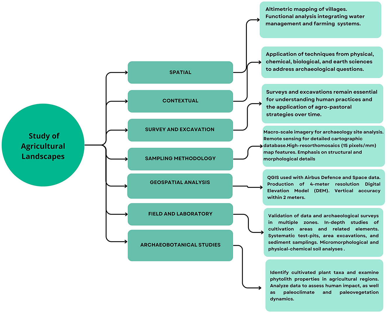
Figure 2. Summary of archaeological research activities conducted in the area.
Research at the Tafí Valley focused on its northern sector, where significant evidence of a substantial occupation was documented through a survey covering ~15 km2, revealing extensive archaeological evidence across this area. This included houses (Salazar, 2010), crop plots (Franco Salvi, 2016), corrals (Chiavassa Arias and Franco Salvi, 2024), irrigation systems, sculptures (Franco Salvi et al., 2020), a ceremonial mound, and several other structures. These findings underscore the complex and multifaceted nature of early settlement patterns in the region. In total, 170 Formative dwelling compounds were documented, accounting for an estimated 30,000 m2 of built space, of which ~16,000 m2 were likely roofed (Salazar and Kuijt, 2016). These dwelling compounds were characterized by spatially segregated architectural units, each covering an area of about 200 m2, and an estimated number of 10-20 inhabitants for each compound (Berberián and Nielsen, 1988). Within these house clusters, we found spaces designated for food storage (Molar and Salazar, 2018) and craft production, as well as the presence of various items meant to emphasize kinship connections, including monoliths and burial sites (Salazar and Kuijt, 2016). Samples of lithics and pottery collected along transects and quadrats exhibited a clear chronological association, primarily dating back to the first millennium CE (Salazar, 2010; Franco Salvi et al., 2014).
Typically, these dwellings featured a central open courtyard, measuring ~10–20 meters in width, surrounded by attached circular rooms with diameters ranging from 2 to 8 meters, all constructed using stone masonry. In general, the residential compounds exhibited similar occupation patterns, encompassing residential structures, agricultural features, and livestock enclosures. Some of these residential buildings were isolated multifunctional units scattered across the landscape, while in other cases, numerous residential clusters were associated with open but enclosed areas featuring specialized functions (Salazar, 2010). Close to the residential areas, 303 agropastoral enclosures were identified, including corrals and agricultural plots, in addition to 28 terraced fields. Collectively, these areas constituted a productive culturally transformed surface of 530 hectares, without considering locations where agriculture may have been possible but left no archaeological traces, possibly due to post-depositional alterations.
The corrals displayed a distinctive architecture, primarily circular or subcircular, often exceeding 8 meters in diameter, some with internal or external enclosures of smaller dimensions, generally <2 meters in diameter. The construction of these enclosures involved single-row piers arranged horizontally, without the use of clay, taking advantage of natural outcrops where available. The connection between these corrals and water resources was evident, with 83.3% of them located within 100 meters of a water source. However, visibility between the village and the corrals was limited (Chiavassa Arias and Franco Salvi, 2024). In terms of pastoral activities, the region's environmental characteristics supported llama husbandry, thanks to the presence of both permanent and seasonal water sources across different altitudinal levels. While faunal remains of camelids were scarce in the archaeological record due to soil acidity, architectural structures indirectly indicated the presence of herding practices (Franco Salvi et al., 2014).
Several types of agricultural features have been identified, which include (a) water management structures (WMS; Marcus and Stanish, 2006), (b) stone clearing heaps, (c) productive enclosures, (d) terraces and (e) grinding areas (Figure 3). These features, with their geometric patterns, were prominently visible on slopes and integrated within the landscape, demonstrating a sophisticated amalgamation of rainfed and runoff-controlled agriculture, complemented by artificial irrigation through canals.
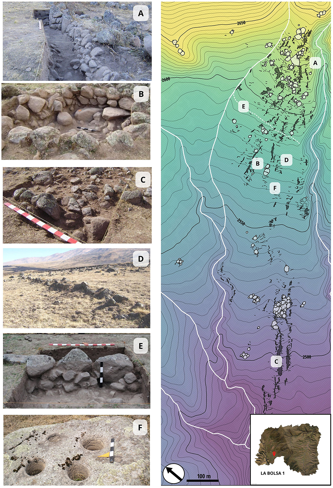
Figure 3. La Bolsa 1 Site: (A, D, E) Terraces; (B, D) Productive enclosures; (C) Stone clearing heaps; (F) Grinding areas.
a. Water management structures ranged from simple soil containment walls aimed at preventing erosion of the fields during the summer months to dams and channels designed to maximize water yield and store it during periods of drought. This variability in water management strategies, manifested through walls, ditches, and other technologies, was archaeologically investigated to establish their chronology and use patterns over time (Figure 4). The research conducted on these structures concluded that the strategies used for water management developed responses both to its abundance during the wet season and its scarcity during the dry season. Constructions to prevent soil erosion and allow water distribution through the fields, for instance, included half-meter-high walls constructed with local rocks, extending for hundreds of meters in areas with a slope between 10 and 20 percent. This mitigated the terrain slope and prevented torrential rains from washing away the crops. Superficially, lines of walls distributed randomly throughout the valley can be easily identified, either isolated or grouped in rows of 5 to 10.
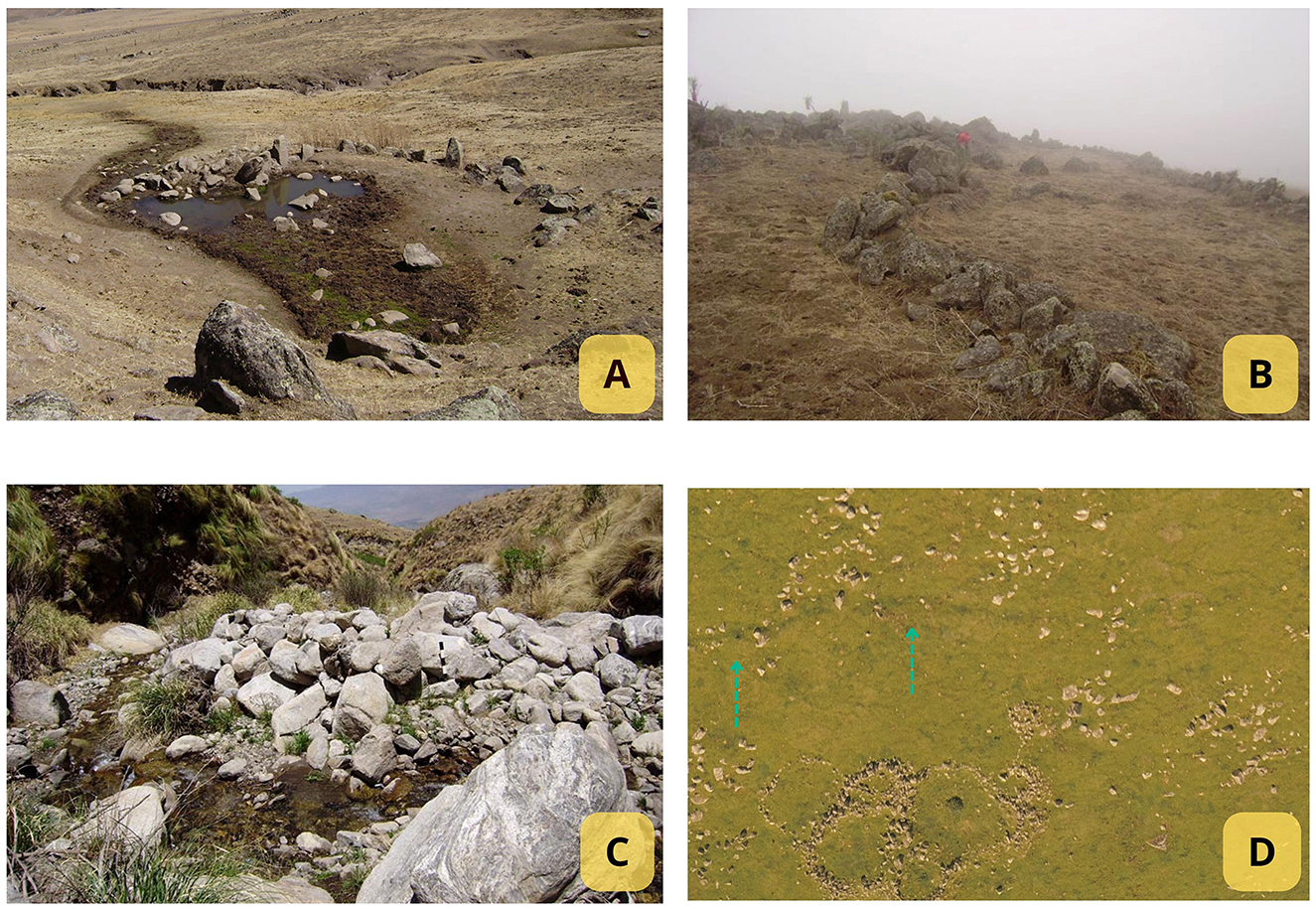
Figure 4. Water management structures: (A) Semicircular structure enclosing a natural spring, with a profile view revealing the main wall (La Bolsa 2 site). (B) Zigzag wall structures (La Bolsa 2 site) designed for soil retention and erosion prevention during summer; the staggered pattern enhances stability and pressure distribution, minimizing collapse risk. (C) Front view of the main dam wall (La Bolsa 2 site). (D) Water management structure—Channel 1 (La Bolsa 1 site).
Another way of managing water, better known in archaeological literature, is defined as an irrigation canal (Quesada, 2006). In La Bolsa 1, a channel with a centrifugal design (Quesada, 2006) was recorded, extending transversely to the slope for almost 1 kilometer, taking water from a permanent stream and ending its course in another stream. Archaeological discoveries have unveiled ancient water management strategies, such as the construction of dams and stone enclosures encircling springs, coupled with the strategic erection of walls to regulate stream water flow. These sophisticated methods allowed communities to safeguard water access, ensuring reliable supply throughout the year for both human and animal needs and crucial crop irrigation, thus showcasing the early villages' expertise in sustainable environmental stewardship.
The stratigraphic excavation of Channel 1 at the LB1 site involved multiple methodologies and yielded significant findings. Initially, photointerpretation revealed a line crossing the site transversely, suggesting a potentially anthropic origin. Subsequently, undulations in the terrain and variations in vegetation coloration were discerned during the survey process (at least 6 features measuring between 200 and 400 meters in length). Geomorphologically, the line adhered to the “V” rule at watercourse intersections, strategically designed to preserve altitude and longitudinal slope, thus mitigating erosion risks and maximizing cultivable land. Three trenches, totaling 15.40 m2, were excavated perpendicular to the feature's direction, offering optimal surface exposure for profiling and stratigraphic assessment. The excavation trenches followed the natural stratum method, which involved identifying distinct stratigraphic units within the soil layers. The first trench (T1), located near a secondary watercourse and away from stone structures, revealed six distinct stratigraphic units, providing a clear sequence of occupation and deposition. The second trench (T2), located in the central section of the feature, helped to confirm the findings from Trench T1, offering additional insights and further enhancing the stratigraphic analysis of the site. Covering an area of 10.8 m2, the excavation of T2 revealed a diagonally oriented stone structure intersecting the feature, along with 10 distinct stratigraphic units, including two channel features. Finally, the third trench indicated a diffuse correlation with a retaining wall, uncovering collapsed structures and additional channel features, suggesting both continuous and intermittent agricultural practices (Figure 5).
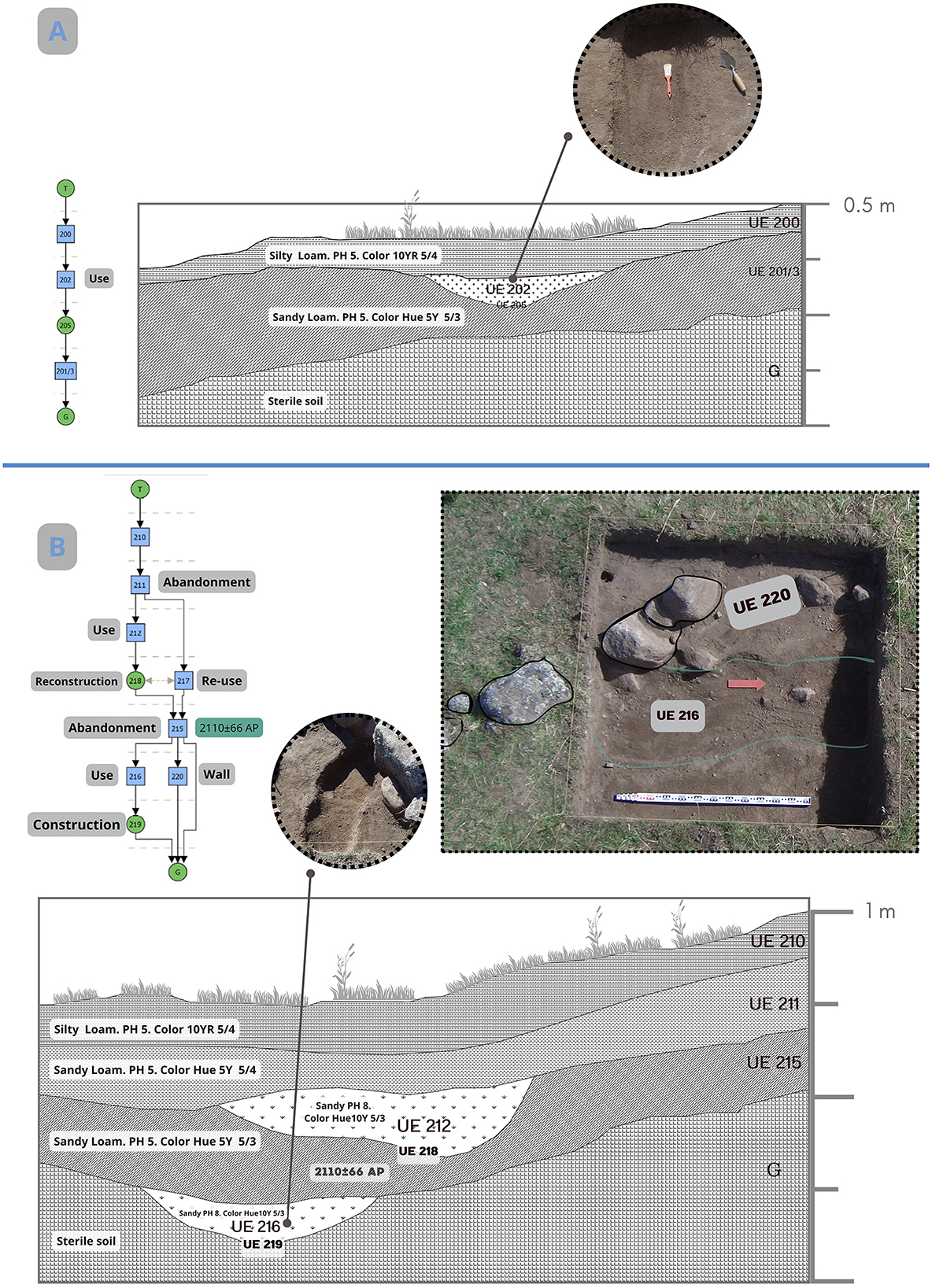
Figure 5. Excavations of WMS: (A) North profile of Trench 1, showing Unit 202 from a top-down view. (B) Trench 2, North profile of stratigraphic features, with a top-down photo of the wall crossing WMS and Unit 2016.
The excavations revealed a single channel with two overlapping sandy strata, separated by a stratum (SU 215). This stratigraphic unit, which indicates a period of abandonment, was dated to 2,110 ± 66 BP and calibrated (with a 95.4% probability) to ranges between 361 BCE and 241 BCE, and between 236 BCE and 27 CE2. This suggests that so far, the structure was one of the earliest built on the site. In short, the stratigraphy observed in WMS-Channel 1 (T2) confirms the existence of cycles of construction, use, abandonment, reconstruction, and reuse, suggesting diachronic agricultural practices. Notably, a wall constructed before 200 BCE redirected water flow, highlighting adaptability to changing circumstances. Based on surface observations and excavations, the structure has been classified as a Water Management System (WMS). This designation highlights its role during both wet and dry periods, allowing for water diversion and flood control (Figure 5). Typically, water diversion refers to an artificial irrigation system that channels water to areas lacking natural flow. However, in this case, the broader term WMS has been chosen to acknowledge that its functionality extends beyond that of a simple channel, encompassing a variety of uses and applications in effective water management.
b. Stone clearing heaps are accumulations of stones resulting from the clearing of plots for cultivation. In some cases, they are organized, forming elongated and linear mounds (as it happens in La Mesada), while in others they appear more disordered, with variable sizes, and lacking a clear morphology (like those in La Bolsa 1). In the area, these stone piles are prevalent, with more than a 100 recorded. Reaching up to two meters in height and extending for a kilometer, they are located adjacent to crop plots, serving to create a favorable microclimate that prevents frost and wind damage. The size and length of these structures—a retainment line that measured ~7 meters in length, with a variable width ranging between 2 and 5 meters- suggest repeated land use over a millennium, with their final size resulting from gradual accumulation rather than a sudden event. The line primarily consisted of small mica and granite rocks, although larger stones were also observed. A trench (6 meters long by 2 meters wide) was excavated to clear and carefully analyze the structure's shape and characteristics. Five stratigraphic units (SUs) were identified, demonstrating that their configuration resulted from the continuous accumulation of stones placed daily during the agricultural production process (Figure 6).
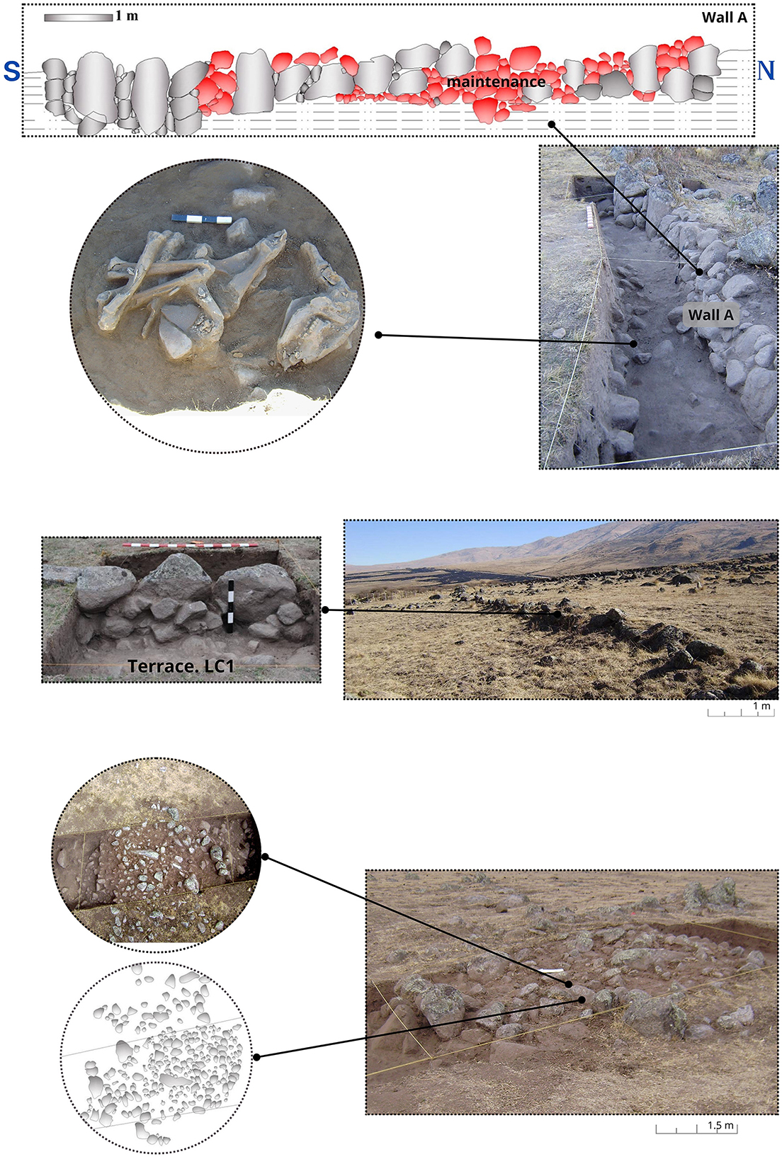
Figure 6. Cultivation Structures excavated in the northern sector of the Tafí valley: Wall A forms a terrace complex associated with a skeletal package used as an offering. Wall A is indicated in red. Below, a stone clearing heap from the La Bolsa 1 site is visible.
c. Productive Enclosures were identified in the northern sector of the archaeological site La Bolsa 1 (at least 10 of them). The walls, constructed of locally sourced rocks (micaceous schists and granite), were positioned transversely to the slope, featuring small drainages measuring 30 cm × 30 cm on average to facilitate water filtration and distribution during the rainy season. A trench was excavated adjacent to the walls of one of these enclosures, along with a pit labeled “F.” Vertical and horizontal soil samples taken from both the trench and the pit revealed chemical differences compared to residential sectors, including lower levels of pH, organic matter, phosphorus, and calcium carbonate.
Field systems defined by stone wall enclosures generally comprised plots ranging from 150 to 400 m2. Identified as a “quadrangular enclosure” due to its architectural features and similarity to other regional agricultural structures (Korstanje, 2005), this type of construction is typical of the period. Such structures were frequently rebuilt with consistent designs and placed within alluvial landscapes. Palynological analysis sheds light on historical environmental conditions, revealing cycles of aridity followed by gradual climate improvement (Grill et al., 2013). Complementary analyses suggest that daily crop cultivation led to a depletion of phosphorus and organic matter, contributing to soil degradation and a rise in calcium carbonate levels (Franco Salvi, 2016).
d. Terraces distributed throughout the northern sector and numbering around 1,000, they exhibit similar features that prompted the selection of multiple sectors for excavation. This aimed to uncover their chronological context, functions, and the factors leading to their eventual abandonment. Notably, two structures located on a 12% slope near residential areas stood out. Six trenches were excavated along Wall A, covering a total area of 20 m2. Additionally, control surveys were conducted in areas unaffected by human activity and in regions distant from the walls within the agricultural plots to investigate the types of cultivated plants (Figure 6).
The entire structure comprises micaceous schists and granites, materials likely sourced from the surrounding area. Adjacent to Wall A, a semi-circular stone feature was uncovered, containing the bones of an adult male camelid alongside ceramic vessel fragments (Kaufmann, 2009; Franco Salvi and Salazar, 2014). This discovery is interpreted as evidence of a ritual sacrifice, a common practice in the Andean region intended to fertilize the land through animal bloodshed to ensure bountiful harvests (Franco Salvi and Salazar, 2014). The stratigraphic association between the construction of the terrace and the camelid burial suggests that the animal held a significant role in the terrace's foundational rites. AMS dating of a phalanx from the skeleton provided a date for this stratigraphic unit of 1,883 ± 46 years BP (bone, δ123C = −19.4‰), corresponding to cal 26 CE−246 CE, positioning this terrace as one of the earliest constructions at the site and offering valuable insights into the region's early agricultural practices (Franco Salvi, 2016; Franco Salvi and Berberián, 2011; Franco Salvi and Salazar, 2014).
Sedimentological analyses were conducted on 50 samples collected from the four identified types of agricultural structures and domestic areas within La Bolsa 1 to gain initial insights into prevailing soil conditions. These samples exhibited significantly lower levels of total phosphorus than those found in residential units and other previously studied areas, suggesting potential soil depletion due to repeated harvesting (Roldán et al., 2009; Salazar, 2010). The phosphorus levels varied from 8.7 to 74.6 ppm, indicating poor soil health and raising questions about the effectiveness of fertilizers in sustaining plant growth and agricultural productivity in these lands (Sandor et al., 1990). Calcium concentrations in the dwellings and cultivated fields were similar, ranging between 0.5 and 1%. Additionally, a discernible gradual decline in soil acidity was observed in the cultivation plots, suggesting a potential trend toward neutrality. This trend was reflected in the pH values of the paleosols, which ranged from 5.33 to 7.22 (Supplementary Material B), indicating that the cultivated fields may have optimized nutrient availability while minimizing toxicity levels (Roldán et al., 2009).
Moreover, a thorough examination revealed a significant decline in organic matter and carbon percentages in deeper layers. In the uppermost layer of the fields, organic matter levels were recorded at 4.23%, accompanied by carbon levels of 2.45%. However, in the paleosol, these values decreased markedly to 0.65 and 0.37%, respectively. This consistent pattern of decline was evident across multiple plots, indicating a generally low presence of organic matter in the cultivated fields (Franco Salvi, 2016). While this trend is observed consistently, further statistical analysis is necessary to substantiate these findings.
For the analysis of plant microremains, soil samples were extracted from profiles corresponding to different types of agricultural structures recurrently found in the northern sector of the valley: terraces and productive enclosures. During successive fieldwork campaigns, 18 soil samples were vertically extracted, and unaltered samples were obtained as “control samples” for comparison with the archaeological sediment (Salazar, 2010; Franco Salvi, 2016).
The analyzed samples revealed a predominant presence of phytoliths, both articulated and non-articulated, and a smaller proportion of starch grains (20%). Maize production emerged as the most significant, followed by legumes such as beans and cucurbits like squash. Evidence of maize was found in various aspects, including production, usage, processing, and consumption (Salazar, 2010; Franco Salvi, 2016). This cereal was not only identified within the agricultural plots but also in handstones and mortars, sediments from cooking enclosures (Franco Salvi, 2016), storage structures (Salazar, 2010), and even in ritual contexts (Salazar et al., 2011). So far, the analyses conducted on the plots have shown limited results. Samples collected from one of the profiles of a terrace (LC1) associated with a dwelling (U14) revealed starch granules and phytoliths with morphologies comparable to those found in squash (Cucurbita sp) leaves and fruits, as well as maize (Zea mays), leaves and fruits (Franco Salvi, 2016; Supplementary Material C).
e. Grinding areas have been primarily identified near residential units and cultivation fields, typically positioned on open-air rock outcrops or large blocks with distinctive perforations. These natural features, which likely served as milling sites for grains, vary greatly in size and shape, with some outcrops having only one or two perforations, while others feature as many as 20. The grinding surfaces are predominantly composed of abundant granitic rocks, native to the region, highlighting the use of local igneous materials.
Geoarchaeological analyses indicate that during the first millennium CE, land use primarily centered around a self-sufficient agropastoral system, with a notable emphasis on agriculture (Sampietro Vattuone et al., 2019). Investigations have also examined residential structures contemporary to agricultural sites. At the La Bolsa 1 site, residential unit U14 (Salazar, 2010) was fully excavated and dated to this period. Microfossil analyses of sediment samples from the floor revealed phytoliths and starch grains linked to maize (Zea mays), including single, polyhedral, spherical, and irregular-elongated forms measuring between 15 and 35 μm. These grains exhibited distinct centric hilum, appearing as dots or lines, with some displaying clear lamellae and a centric cross with four visible arms. Starch grains from beans (Lupinus mutabilis) were also identified, characterized as single, oval, and measuring 38 μm on average, with an indistinct centric hilum, no visible lamellae, and a lightly eccentric cross with four arms and a distinct border (Figure 7; Salazar and Kuijt, 2016).
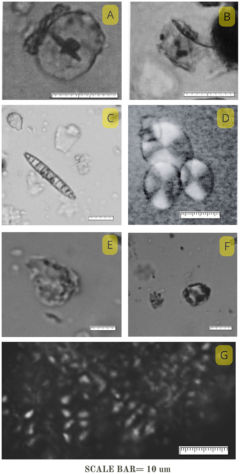
Figure 7. Phytoliths and starch granules: micro-remains from terrace profiles at the La Bolsa 1 site. (A) Phytolith resembling Cucurbita sp. (Squash); (B) Phytolith resembling Zea mays (Maize); (C) Diatom; (D) Granules resembling Phaseolus sp. (Beans); (E) Phytolith resembling Cucurbita sp. (Squash); (F) Phytolith resembling Zea mays (Maize); (G) Starch granules resembling Chenopodium sp.
The analysis of grinding tools further confirms that these crops were processed within the dwelling, and chemical analyses of the soil indicate that the site was organized around the processing and consumption of these plants (Salazar, 2010). Excavations revealed that maize was ground and food was stored in a central unroofed enclosure (Patio; Molar and Salazar, 2018). Microbotanical elements in the sediments surrounding the grinding tools reinforce the conclusion that maize processing occurred on-site. Additionally, studies of lipids and microremains from grinding tools at El Rincón 1 (RN1) and El Rincón 2 (RN2) in the southern Tafí Valley provide further insights into agricultural practices. These settlements consist of residential units featuring circular rooms centered around a patio (García Azcárate, 1996; Cuenya and García Azcárate, 2004). Inside these dwellings, grinding tools were found containing microremains of common bean (Phaseolus vulgaris) and carob (Prosopis sp.), with associated radiocarbon dates ranging from 325 ± 40 CE to 585 ± 40 CE (Cuenya and García Azcárate, 2004). Organic residue analysis indicates the presence of plant waxes exclusively (Babot, 2004).
In summary, cultivation practices throughout the Tafí Valley are well-documented, corroborated by geomorphological studies that record landscape erosion resulting from these practices and archaeobotanical and lipid analyses demonstrating that these plants were processed using grinding tools.
Our second case study is La Ciénaga Valley, where we conducted a systematic survey covering 18 km2. This region is considered a palimpsest of human activity across multiple periods, with evidence of intensive occupation during the first millennium CE, followed by less frequent, though significant, occupations dating back over 2,000 years. Located adjacent to Tafí, La Ciénaga shares similar ecological features but is characterized by a more secluded and narrower valley compared to its neighboring counterpart (Figure 1).
The presence of over 2,000 enclosures and wall structures was determined in this area as a result of archaeological surveys and assessments, comprising nearly 200 architectural compounds distributed across various archaeological sectors named according to local toponymy. A total of 129 formative dwelling compounds were documented, accounting for an estimated 22,800 m2 of constructed space, with ~12,160 m2 of that space featuring roofs. These dwellings featured a central courtyard surrounded by attached enclosures arranged in a circular layout, following the identical construction pattern found in Tafí, thus linking both structures to a shared cultural tradition. Additionally, in the central area of La Ciénega, situated at a higher elevation to the west, an elevated surface with an ellipsoidal plan resembling a burial or ceremonial mound was identified. These structures are a common feature in the early stages of village development in Northwestern Argentina (Tartusi and Núñez Regueiro, 2001). The survey recorded circular and sub-rectangular roofed and unroofed structures, stone walls, stone clearing heaps, linear walls, milling areas, and engraved rocks. Additionally, 140 stone corral structures were identified, typically circular or subcircular, isolated or in clusters of up to three, with diameters exceeding 8 meters. These were built from unbound rock blocks situated at altitudes above 2,900 m asl and on slopes >15%.
The use of Geographic Information Systems (GIS) to identify the structures was indispensable, especially due to the limited presence of surface agrarian stone structures. This tool was pivotal in our analysis, suggesting the likely existence of an agriculture system reliant on rainfall, with minimal reliance on structures, except for occasional soil retaining walls, stone clearing, and isolated enclosures in specific areas. The spatial analysis played a crucial role in shaping our initial hypotheses, particularly in assessing the agricultural viability of the land (Figure 8).
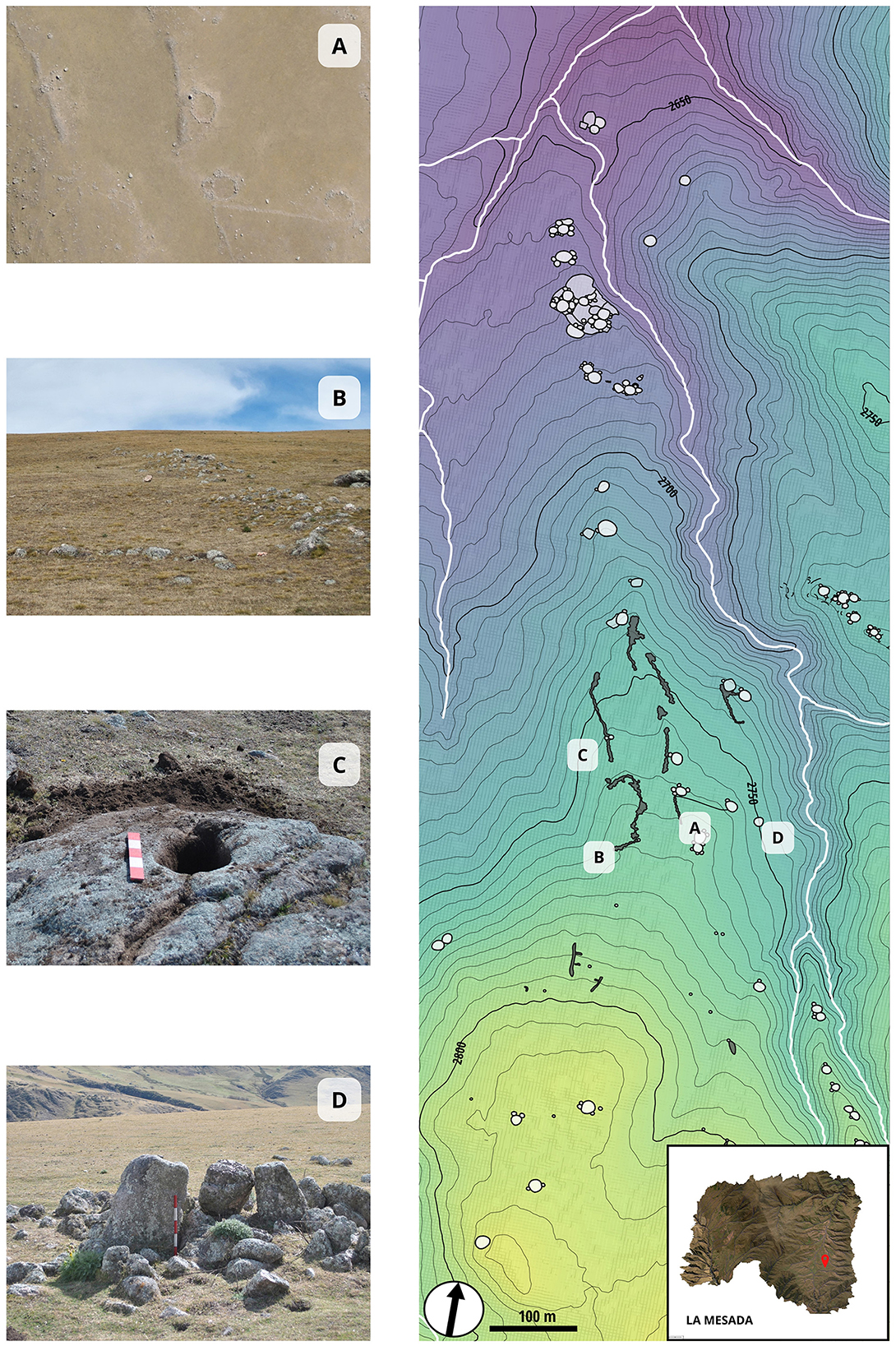
Figure 8. La Mesada Site, La Ciénega valley: (A) Productive enclosures; (B) Stone clearing heaps; (C) Grinding area; (D) Temporary shelters.
Approximately 85% of the archaeological evidence in the La Ciénega valley was documented using UAV orthophotos, pinpointing key features like central points of domestic units, open productive enclosures, and a distinctive earth mound structure. Analysis of a VHP-DTM with 4 m resolution involved reclassifying slopes based on FAO criteria. Nearly 27% of the area comprises slopes under 10%, indicating significant agricultural potential. Comparative slope analysis demonstrated that these areas cover almost all cultivable terrain in the valley's immediate domestic spaces. Each household was estimated to have access to ~2.97 hectares of cultivable land, including those with favorable slopes (Figure 9).

Figure 9. La Ciénega valley is delineated by the red line: (A) Layout of domestic (black) and productive (red) structures, with dots representing the centroid of each household cluster and unroofed productive enclosures. A triangle indicates a potential isolated earth mound of religious or political significance. (B) Cumulative catchment area within a 5-min radius of household centroids, with light blue areas showing overlapping domestic clusters. Darker shades represent higher densities, totaling 383.80 hectares, with 103.52 hectares identified as high agricultural potential due to favorable slopes and irrigation. (C) Density curves for domestic (red) and productive (blue) structures based on centroid data from the Household Cumulative Viewshed GIS layer, with interquartile ranges indicated by dashed lines and medians by solid lines.
Structural visibility analysis revealed differing prominence between domestic and productive units in the landscape, with domestic units showing low visibility and a bimodal distribution, while productive units exhibited more uniform visibility than domestic areas. Normalized vegetation indices captured variations in plant vitality across different seasons, noting reduced activity in August compared to heightened vitality in April, influenced by moisture retention patterns throughout the year (Huete, 1988). These indices were pivotal in identifying potential pre-Hispanic agrarian sites, considering factors such as humidity, slopes, and sun exposure (Figure 9). The digital settlement model created from UAV data facilitated the delineation of a catchment area within a 5-min isochrone, highlighting the valley's agricultural potential. Detailed analysis of multispectral imagery provided insights into moisture distribution and vegetation health, complemented by assessments of slope distributions, orientations, and altitudes, revealing distinct spatial patterns in the placement of domestic and productive structures. Residences typically clustered in slightly elevated areas on the valley floor, while productive areas were concentrated in steeper sectors, particularly within the 15 to 30% slope range (Figure 8). Most dwellings are concentrated slightly above 2,740 m asl, predominantly located in the upper portion of the zone designated as the “valley floor,” reinforcing the notion of a layout adjacent to flat lands. Considering factors such as slope, proximity to dwellings, and water accessibility, alongside favorable soil conditions, a total of 151 hectares suitable for cultivation within the valley have been identified. Drawing from our analysis of the population dynamics and under the assumption of synchronized habitation patterns to denote the maximum potential population, our estimations point toward a community comprising ~129 residential units. While assessments of agricultural potential may suggest a lower figure, it is also necessary to take into account the pivotal role of herding, hunting, gathering, and resource exchange in supporting the community across diverse ecological strata.
Residential units are strategically positioned on both sloping and steep terrains, adjacent to flat lands, while animal enclosures are predominantly located on slopes ranging from 15 to 30%. Visibility studies confirm that corrals and cultivated fields within the valley are observable from domestic units, emphasizing the profound interconnectedness of living and productive spaces within this community. The orientation of the structures suggests a nuanced understanding of productive units, primarily facing northeast, likely aimed at maximizing sunlight and warmth, possibly in relation to the needs of animal husbandry. Moreover, the spatial organization of residential units, including roofed spaces and kitchens, was also designed to mitigate the need for such environmental conditions, being mainly oriented to the north (Table 1).
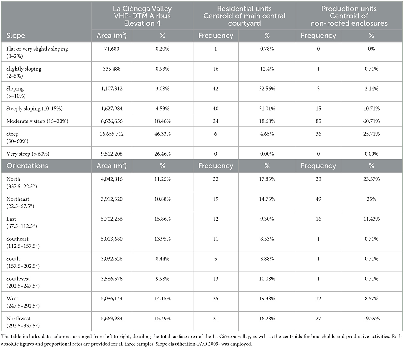
Table 1. Slope classification according to the FAO 2009 soil categorization guide.
In La Ciénega Valley, several stone structures have been identified, likely used in a complementary manner for cultivation, herding activities, and water distribution in specific areas (Figure 8):
a) Productive enclosures: In the La Mesada sector, 150 stone structures have been identified across an area of 1,000 m2 at an altitude of 2,800 m asl. Agricultural structures comprise the majority of these (53%), organized into large enclosures arranged in rows of four or five along the alluvial terrace. These constructions were likely used for cultivation, potentially alongside gently sloping areas, eliminating the need for additional features such as terraces. Similarly, in the El Arenalcito area, circular and subcircular enclosures surrounding dwellings have been identified, serving dual purposes for animal confinement and agricultural activities. These enclosures played a vital role in protecting crops from adverse environmental conditions.
b) Stone clearing heaps: Within the Río de las Piedras area, 113 surface stone structures have been identified, which, due to their characteristics and proximity to dated sites, are believed to correspond to the first millennium CE.
c) Grinding Areas: These areas exhibit significant variability in shape and size, ranging from small mortars to large cavities, arranged on open-air rock outcrops or blocks. They have been identified in association with residential units, cultivation fields, and highly visible sectors. Additionally, eight large blocks with multiple hemispherical cavities of varying sizes have been identified.
d) Temporary shelters: In an alluvial fan near the El Sauquito River, an ancient agricultural area with numerous cultivation structures comprising aligned stone mounds and attached individual enclosures has been observed. These circular enclosures, characterized by a small diameter, may have served as temporary shelters and storage structures during the summer cultivation periods, given the absence of artificial irrigation systems.
In La Ciénega, several initiatives have been undertaken to deepen our understanding of the agricultural potential of the region, as well as the variety of circulating plants and aspects related to food production. Cremonte (1996) initiated an extensive soil analysis in La Ciénega Valley to assess the agricultural potential of the local soils. This comprehensive study entailed the examination of samples extracted from a sedimentary profile near the residential units in the southern sector. Parameters such as texture, pH levels, organic matter content, and mineral composition underwent a thorough examination. The analysis identified three distinct lithological units, each exhibiting diverse texture and mineral composition characteristics. Despite slightly acidic pH levels averaging five, the soils were considered conducive to agricultural activities, with an ample abundance of essential elements such as calcium, potassium, and magnesium (Cremonte, 1996). Cremonte's comprehensive study revealed no discernible soil or climatic impediments that would prevent the cultivation of staple crops like potatoes or maize in the region. On the contrary, the seasonal phenomenon of soil freezing, identified as a prevalent occurrence, emerged as a beneficial factor facilitating agricultural labor by expediting weathering processes and water retention capacities (Cremonte, 1996).
Archaeobotanical studies conducted at the sites of El Pedregal (EP) and El Arenalcito (EA) revealed the presence of charred beans (Phaseolus sp.) within the dwellings, suggesting cultivation practices took place there during the first millennium (Cremonte, 1996). While it has not been conclusively determined whether these beans were intentionally cultivated, the abundance of grinding tools, primarily handstones, scattered throughout the residential areas provides compelling evidence of the central role of starchy foods in the dietary habits of La Ciénega's ancient inhabitants. These artifacts, serving as indirect indicators, underscore the likelihood of maize consumption and possibly quinoa utilization, alongside various foraged products integral to the sustenance of La Ciénega and Tafi communities.
A recent study conducted by Vázquez Fiorani et al. (in press) at Lomita del Medio (LDM) examined organic residues in pottery, providing valuable insights into the diets of its inhabitants. The analysis revealed that most vessels contained evidence of the processing of plant-based resources such as maize, squash, and beans. In contrast, only a few showed traces of animal fat, likely from herbivores such as llamas. This research suggests a much greater emphasis on plant processing than previously recognized. Using chromatographic analysis combined with mass spectrometry, the study identified a variety of compounds, including fatty acids, sterols (notably stigmasterol and sitosterol), waxes, and fatty alcohols—some of which serve as specific biomarkers for maize. These findings raise further questions about agricultural practices at the time and underscore the importance of understanding ancient subsistence strategies to illuminate the lifestyles of past societies. In the same archaeological site, Montegú et al. (2021) conducted preliminary archaeobotanical studies focused on artifacts such as knives recovered from Unit 18 (LDM), which originates from enclosure 94—a sector designated for food preparation and cooking—dating back to the 2nd to 7th century CE. Intriguingly, their analysis revealed the presence of silica phytoliths and starch granules reminiscent of those found in maize, squash, and quinoa on the knives' edges along with a remarkable abundance of diatoms. Importantly, meat fibers were also detected on the knives, suggesting multifunctional use in food preparation. These findings may provide indirect evidence of local plant cultivation, based on the presence of phytoliths and starch grains associated with these species. These results enrich our understanding of the site, indicating not only plant processing activities took place there but also the possibility of local cultivation (Figure 8).
The agrarian landscape of Tafí today reflects a complex interplay of enduring agricultural practices shaped by generations of community knowledge and adaptation. Significant continuities in the region's agricultural traditions can be observed in both Tafí and La Ciénega. Smooth red maize, petite “capiar,” larger white maize, and slender “Luquita” corn, along with native Angola (Cucurbita pepo), potatoes (Solanum spp.), and pallar beans (Phaseolus cf. P. lunatus), continue to thrive in local gardens. These varieties have been cultivated for over two millennia, as evidenced by archaeological findings (Franco Salvi et al., 2023).
Notably, pallar bean production in Tafí demonstrates remarkable yields of up to 60 bags of 50 kg per hectare per season, achieved without significant infrastructure investments or reliance on chemical inputs. This perdurance is a testament to ancestral agricultural wisdom, which persists even in the face of modern innovations. For instance, the experimental station in Tafí introduced alternative crops, yet these have not matched the productivity of traditional varieties.
In certain isolated areas of Tafí, traditional “mantle” irrigation (flooding) continues to support the cultivation of criollo and capia corn, squash, and peas, practices passed down through generations. Native potato cultivation is primarily found in the lower areas near the valley entrance. Additionally, wheat farming and the use of wheat mills were prominent activities until the 1960s, but urbanization has since restricted access to irrigation water, contributing to the decline of these farming practices. The migration of highland residents to the Tafí Valley has also diminished bartering opportunities, as the scarcity of agricultural activities suitable for exchange has increased.
In La Ciénega, vegetable cultivation thrives, with crops such as lettuce, radish, and green onions being successfully grown. However, challenges persist with tomatoes and peppers. Occasionally, “zapallo criollo” (Cucurbita maxima), native to the area, is cultivated, though less frequently. During periods of lower activity, community members devote meticulous care to these crops, tending to small plots adjacent to their homes with hand watering. However, the proliferation of weeds poses significant challenges to maintaining production. The contemporary agrarian landscape of Tafí reveals several key continuities in agricultural practices. The sustained selection and cultivation of maize varieties—such as smooth red maize, “capiar,” white maize, and “Luquita”—reflects generations of accumulated knowledge and a commitment to crop conservation. Farmers continue to employ traditional irrigation methods, notably “mantle” irrigation, and rely on ancient agricultural tools like digging sticks. The integration of maize with other complementary crops, including native Angola, potatoes, and pallar beans, promotes agricultural diversity and enhances food security, echoing historical practices. Despite exposure to new ideas and technologies, such as experimental stations and novel crop varieties, farmers remain committed to traditional methods, given their proven effectiveness and suitability to the local environment (Franco Salvi et al., 2023).
After numerous fieldwork seasons that comprised surveying a total of 40 km2 and excavating more than 600 m2 of dwellings, burial mounds, agricultural structures, and corrals, the question arises: what is the importance of the relative autonomy of domestic units in shaping an agrarian landscape that remained active for nearly seven centuries in the Calchaquí valleys? The evidence reveals an agricultural system that thrived over an extended period in the valleys under study, supported by intricate social dynamics within these communities, and reliant on a sophisticated agricultural infrastructure. This versatility stemmed from a deep understanding of ecology, environment, and natural phenomena, exemplifying perdurability despite challenges like uneven terrain, sporadic water access, absence of draft animals, and harsh climatic conditions at higher altitudes. Flexibility and adaptability were key components, leading to positive outcomes in food production and enduring agricultural practices. This article synthesizes pre-Hispanic agricultural practices in the Tafí and La Ciénega valleys during the first millennium CE. The sustenance of these communities relied on various features, including water management structures (WMS) utilized in times of both scarcity and abundance, the construction and maintenance of terraces, cultivation of the maize-bean-squash triad, and the construction of corrals in steep sectors adjacent to agrarian areas (Figure 10). While the data suggest a synchronous use of these cultivation strategies throughout the first millennium, evidenced by similarities in architecture, radiocarbon dating results, and the characteristics of ceramics and lithics found in these contexts, we also identified diachronic processes. These include phases of WMS- Channel 1 use, abandonment, and subsequent reuse. Despite potential changes in agricultural practices over time, certain strategies remained constant throughout the main occupation of these valleys, particularly the utilization of water management devices.
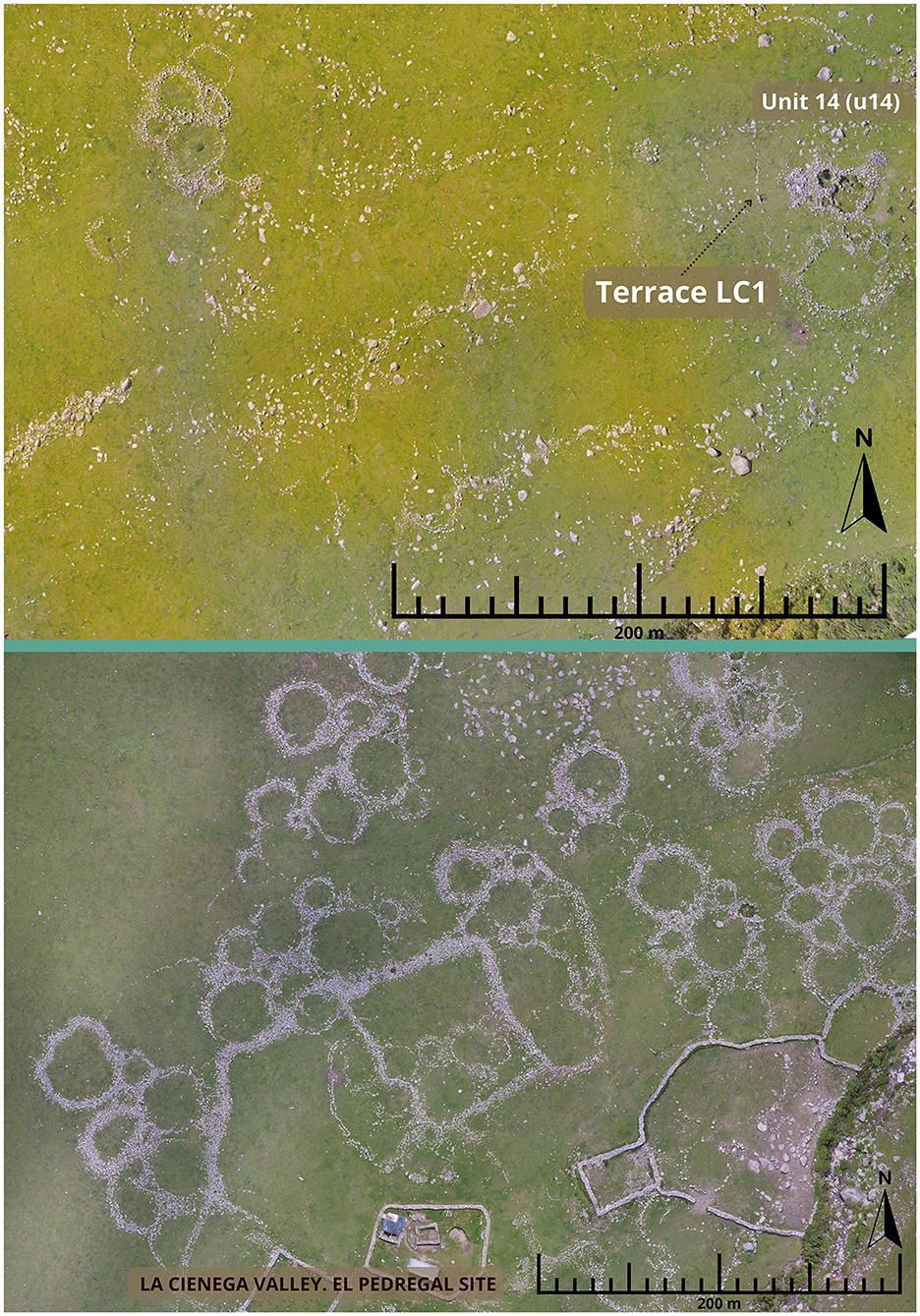
Figure 10. Aerial view of settlements from the first millennium CE.
Using QGIS, our analysis showed that the northern Tafí region has steeper slopes averaging 15%, which required extensive construction of terraces, channels, dams, and designated planting areas to manage the rugged terrain effectively, covering 500 hectares designated for cultivation. In contrast, La Ciénaga exhibited gentler slopes, which required less infrastructure investment for cultivation, although our analysis identified 380 hectares as suitable for agriculture.
The sustainability of the agrarian landscape was due not only to the techniques employed—optimizing agricultural production, promoting soil conservation, and efficiently managing water and reducing risks—but also to the social structure that oversaw it. Household units, operating with relative autonomy, were able to manage production effectively. This sustainability, sensu (Jacobson, 2022), defined as the efficient long-term management of resources, was evident in nearly 7 centuries of continuous cultivation, suggesting that populations successfully persisted over time. However, this should not be equated with resilience (Jacobson, 2022). While certain landscape trends were maintained, the ability of the social structures of these populations to adapt to significant changes in production constraints is a distinct aspect, one that cannot be assumed.
In the case of the studied valleys, it can be argued that these agrarian landscapes were not resilient to the more arid climatic conditions that developed toward the end of the first millennium, particularly between the 8th and 10th centuries CE (Garalla, 2003; Sampietro Vattuone, 2001). During this period, agricultural and residential structures were abandoned on various scales. Previously, agricultural activity had been sustained without clear evidence of conflict, famine, or disruption. While disturbances may have occurred, populations were able to persist, and as Jacobson (2022) and Bradtmöller et al. (2017) note, there is no universal strategy for success in all contexts. In the case of these valleys, autonomous household units effectively managed production without a centralized structure. However, this autonomy—key to the sustainable agricultural system over centuries—may have proved to be a limiting factor when confronted with novel demographic or climatic shifts, such as the population density reached by the highly productive basins or the droughts that impacted the region at the end of the first millennium.
Archaeobotanical investigations in the valleys and ravines of the region have revealed the diverse cultivation practices of ancient village communities. Maize (Zea mays) stands out as the primary crop, supplemented by other crops such as beans (Phaseolus sp.), squash (Cucurbita maxima), quinoa (Chenopodium quinoa), and amaranth (Amaranthus sp.). Additionally, while direct microscopic or macroscopic evidence is lacking, the potential presence of cold-resistant tubers like potatoes (Solanum tuberosum) and oca (Oxalis tuberosa) remains important. These crops are prominent in contemporary valley economies, suggesting they may have been cultivated in the past, given the favorable environmental conditions and agricultural advancements observed in the area today. Alongside cultivated crops, the gathering of natural resources also played a vital role. Species such as “algarrobo” (Prosopis sp.) and chañar (Geoffroea decorticans), collected from areas outside the valley, have been identified in residential and ceremonial zones. These plants were likely used for various purposes, including food preparation, consumption, storage, and even as fuel sources (Carrizo et al., 1999; Korstanje et al., 2015).
An enduring agricultural practice that has persisted for millennia is a technique that involves planting maize and squash seeds together in the same hole. This method creates a symbiotic relationship between the two crops: as the maize matures, its tall stalks reach for sunlight, while the squash sprawls across the ground, effectively suppressing weed growth (Rosset and Altieri, 1997). Additionally, beans contribute significantly to this system through their unique ability to fix nitrogen in the soil. This natural enrichment benefits neighboring crops like maize and squash, reducing reliance on synthetic nitrogen fertilizers and enhancing the overall efficiency of agricultural practices. The deep roots of beans also help break up compacted soil, improving soil structure and increasing its capacity to retain water and nutrients. These advantages extend not only to the beans themselves but also to the adjacent crops, creating a more resilient and productive agricultural ecosystem.
Observations of contemporary traditional cultivation methods—characterized by the absence of animals or machinery, the avoidance of agrochemicals, and the cultivation of a triad of crops including maize, squash, and beans—reveal practices in the Tafí Valley that bear striking similarities to those of over 2,000 years ago. While these modern methods suggest a continuity with ancient agricultural traditions, there is still insufficient research to establish whether such practices have been maintained continuously since the first millennium. The resemblance to past practices is notable, but further studies are needed to confirm the continuity of agricultural activities over time (Franco Salvi et al., 2023). In contrast, today La Ciénega supports only 10 families, with a strong emphasis on livestock farming. This small, livestock-centered community structure stands in clear contrast to the more extensive agricultural practices that likely characterized the region in the past.
Soil conditioning, stone wall construction, and water management were essential elements of agriculture; however, symbolic rituals also played a significant role in its development. A compelling example is the discovery of an offering that included a llama (Lama glama) skeleton and ceramic artifacts, all encased within a mound of stones. The stratigraphic context and absolute chronology of this find suggest it may represent a founding ritual associated with constructing agricultural terraces, highlighting the cultural significance of rituals in shaping agricultural practices. Farming involved interactions with non-human entities, including llamas and ancestors represented in menhirs (oblong carved stones arranged in a megalithic style), which are still acknowledged in certain cultivation plots today. Sacrificing and offering food to the Earth constituted an integral element in food production, prompting contemplation of numerous other factors not preserved in the archaeological record, such as the influence of stars, colors, sounds, and visibility (Tillmann, 1997). Based on agricultural practices today, it's clear that the position of stars and constellations holds significant importance in determining optimal times for planting, harvesting, and other agricultural tasks. The discovery of offerings on the terrace (Wall A, La Bolsa 1), coupled with the consistent presence of megaliths strategically positioned within the crop fields, underscores the profound reverence for deities in exchange for protection. This reverence reflects not only a particular worldview but also an enduring ancestral wisdom deeply embedded in the cultural fabric of the community.
The presence of camelids and pastoral practices is evident not only in faunal remains but also in ceramic statuettes and menhirs, with studies identifying hundreds of corrals in nearby rugged terrain, easily visible from the fields (Chiavassa Arias and Franco Salvi, 2024). The architecture of these corrals exhibits similarities in construction with cultivation terraces, suggesting a close relationship between these structures. Furthermore, the ceramic and lithic materials discovered in surface collections and excavations indicate that they likely operated in tandem with the agricultural system, implying a complex and integrated approach to land use in the region. In this context, it becomes apparent that for the agricultural system to maintain sustainability, it likely relied on the observance of rituals likely aligned with astronomical cycles, attuned to the natural symphony of sounds—birdsong, patterns of wind, and the behaviors of animals—alongside the ancestral wisdom passed down through generations. Additionally, integral to this harmony were the contributions of non-human entities like llamas, deeply intertwined with the daily rhythms of these communities (Ferrari et al., 2021).
Ceremonial practices, particularly those observed on the terrace -Wall A-, were fundamental to this intricate system, illustrating how interactions among various activities within a decentralized environment led to mutual benefits and effective resource management. However, this portrayal of cooperation was accompanied by underlying complexities, with ongoing negotiations and tensions among families, often mediated by ancestral wisdom, serving as persistent elements. As the 3rd century CE progressed, these tensions seemed to escalate, underscoring the nuanced dynamics within these communities (López Lillo, 2017).
A significant aspect reinforcing the concept of family-scale work is the fragmentation observed in the agricultural plots at the site and in the northern part of the valley. In these areas, cultivated plots rarely exceed 400 m2 and are distinctly organized. This is evident through the presence of rectangular or subcircular structures, which serve as canchones or cultivation squares, as well as the installation of terraces and retaining walls aligned with stone clearing heaps. Unlike the cultivated fields of the late period in northwestern Argentina, which tend to be spatially segregated, in this case, the crops are solely associated with the dwellings. The maintenance and construction processes documented during the excavations of these agricultural structures suggest that small groups of people managed them. Moreover, the gradual construction of the stone clearing heaps is notable. Initially, large rocks were placed to demarcate non-cultivable areas, and stones cleared from the fields were added over time, indicating that the work was carried out gradually by small family groups across multiple seasons.
Wall “A” of the platform (Figure 6) exemplifies care and maintenance practices. While the ends of the wall are well preserved, the central part shows significant deterioration due to soil erosion, suggesting it required continuous repairs. This frequent need for maintenance may have prompted the construction of a second wall as a strategy to minimize the risk of collapse. The double row observed, notable for its size, was likely built progressively over successive family work seasons. Similarly, the longitudinal walls of the platform appear to have been constructed sequentially, reflecting the same process seen throughout the entire structure. This aligns with observations made inside the dwellings, where the strong autonomy of residential units has been demonstrated (Franco Salvi, 2016; Salazar, 2010).
Central to this dynamic was the social fabric, characterized by domestic units autonomously carrying out agricultural work without hierarchical structures or defined specializations (Salazar et al., 2008; López Lillo and Salazar, 2015; Salazar and Kuijt, 2016; Franco Salvi, 2019). This allowed for individual attention to each plot, guided by accumulated family knowledge, and facilitated flexible management in response to changing needs. The absence of a centralized authority for agricultural demand ensured fluid coordination based on environmental contexts and other productive activities, such as herding, enhancing soil fertility, and post-harvest plot cleanup to promote optimal field performance. Crucially, these communities seem to have operated free from directives aimed at homogenizing practices or fulfilling mandates from centralized power structures. This autonomy allowed them to maintain their unique approaches to cultivation and caring for the land, ensuring sustainability tailored to their specific environmental and social contexts.
Understanding how ancient populations adapted and organized themselves in diverse natural environments, and recognizing the pivotal role of agro-pastoral production in shaping social structures, highlights the importance of identifying historical practices that influenced political dynamics over centuries. The concept of revitalizing agriculture using traditional techniques and strategies to enhance sustainability in environmentally stressed regions holds considerable appeal. However, proposing the reintroduction of ancestral techniques in contemporary times requires acknowledging inherent challenges. It is essential to understand that these practices evolved within specific social contexts vastly different from those of today. The conditions that enabled these agricultural techniques were intricately tied to the social relationships prevailing at the time. Essentially, they relied on highly autonomous household units cultivating land in a contextually sensitive and flexible manner, independent of state enforcement of decisions taken outside local neighboring communities.
Hence, achieving sustainability in modern contexts demands a comprehensive understanding of historical contexts and prevailing social dynamics. It entails navigating the complexities of adapting ancient practices to contemporary realities, recognizing that the transition is not straightforward. It requires a nuanced approach that respects the historical context while acknowledging the evolving political, economic, and social landscapes of today.
The raw data supporting the conclusions of this article will be made available by the authors, without undue reservation.
VF: Conceptualization, Data curation, Formal analysis, Funding acquisition, Investigation, Methodology, Project administration, Resources, Software, Supervision, Validation, Visualization, Writing – original draft, Writing – review & editing. JL: Data curation, Formal analysis, Funding acquisition, Investigation, Methodology, Software, Writing – original draft, Writing – review & editing. JS: Data curation, Formal analysis, Funding acquisition, Investigation, Methodology, Project administration, Resources, Supervision, Validation, Visualization, Writing – original draft.
The author(s) declare financial support was received for the research, authorship, and/or publication of this article. This research was funded by SECyT (Secretaría de Ciencia y Tecnología, Universidad Nacional de Córdoba) and CONICET (National Scientific and Technical Research Council), with additional support from the Spanish National Research Council (CSIC) through project PIAR_2021-07. The topographical work conducted in La Bolsa-Carapunco received partial funding from Fundación Palarq under a new project, with primary support from the Ministry of Culture of the Government of Spain.
We extend our sincere gratitude to the EASCC project team for their invaluable collaboration. Acknowledgments are also due to our funding sources. Special appreciation goes to the symposium coordinators: Dr. Verónica Zuccarelli, Dr. Enrique Moreno, and Dr. Celeste Samec for their guidance and unwavering support. Finally, we express our profound thanks to the Diaguita Indigenous Communities of Tafí and La Ciénega for their ongoing companionship and collaboration throughout the years.
The authors declare that the research was conducted in the absence of any commercial or financial relationships that could be construed as a potential conflict of interest.
All claims expressed in this article are solely those of the authors and do not necessarily represent those of their affiliated organizations, or those of the publisher, the editors and the reviewers. Any product that may be evaluated in this article, or claim that may be made by its manufacturer, is not guaranteed or endorsed by the publisher.
The Supplementary Material for this article can be found online at: https://www.frontiersin.org/articles/10.3389/fearc.2025.1453746/full#supplementary-material
1. ^OpenDroneMap. WebODM. GitHub (https://github.com/OpenDroneMap/WebODM).
2. ^All samples were calibrated using the OxCal v4.4.4 program (Bronk Ramsey, 2021), in conjunction with the latest calibration curves, ShCal20 (Hogg et al., 2020).
Albeck, M. (1993). Contribución al estudio de los sistemas agrícolas prehispánicos de Casabindo (Unpublished PhD thesis). Facultad de Ciencias Naturales y Museo, Universidad Nacional de La Plata.
Albeck, M. (2000). “La vida agraria en los Andes del Sur,” in Nueva Historia Argentina, Tomo I, Ed. M. Tarragó (Buenos Aires), 187–228.
Albeck, M. (2003). Sistemas agrícolas prehispánicos: la búsqueda de indicadores cronológicos y culturales. Cuadernos del Instituto Nacional de Antropología y Pensamiento Latinoamericano 20, 13–26.
Babot, M. P. (2004). Tecnología y utilización de artefactos de molienda en el noroeste prehispánico (Unpublished PhD thesis). Universidad Nacional de Tucumán.
Berberián, E., and Nielsen, A. E. (1988). Sistemas de Asentamiento Prehispánicos en el Valle de Tafí. Ed. Comechingonia. Córdoba. Argentina.
Berberián, E., and Raffino, R. (1991). Culturas indígenas de los Andes Meridionales. Alambra Longman: Madrid.
Bradtmöller, M., Grimm, S., and Riel-Salvatore, J. (2017). Resilience theory in archaeological practice–an annotated review. Quat. Int. 446, 3–16 doi: 10.1016/j.quaint.2016.10.002
Bronk Ramsey, C. (2021). OxCal v.4.4.4 [software]. Available at: https://c14.arch.ox.ac.uk/oxcal.html (accessed June 2024).
Carandini, A. (1997). Historias en la Tierra: manual de excavación arqueológica. Ed. Crítica. Barcelona.
Carrizo, J., Cano, S., and Soler Nixdorff, M. (1999). “Recursos vegetales comestibles en el Valle de Tafí durante el período Formativo: análisis arqueobotánico I del sitio Casas Viejas- El Mollar (S TUC TAV 2),” in Actas del XII Congreso Nacional de Arqueología, Tomo I. La Plata, 65–73.
Chiavassa Arias, S., and Franco Salvi, V. L. (2024). El pastoreo en un paisaje aldeano del valle de Tafí (Tucumán, Argentina). Arqueología 30, 1–24. doi: 10.34096/arqueologia.t30.n3.13395
Cremonte, M. (1988). Comentario acerca de fechados radiocarbónicos del sitio El Pedregal (Qda La Ciénaga, Tucumán, Argentina). Chungara 20, 10–18.
Cremonte, M. (1996). Investigaciones arqueológicas en la Quebrada de la Ciénaga (dto. Tafí, Tucumán). Unpublished PhD thesis. Universidad Nacional de La Plata.
Cučković, z. (2016). Advanced viewshed analysis: a quantum GIS plug-in for the analysis of visual landscapes. J. Open Source Softw. 1:32. doi: 10.21105/joss.00032
Cuenya, M., and García Azcárate, J. (2004). Procesos de formación de sitios arqueológicos y su relación con cambios pedológicos, El Rincón, Tafí Del Valle, Tucumán. Chungará, 36, 415–423. doi: 10.4067/S0717-73562004000300043
Erickson, C. (2006). “Intensification, political economy, and the farming community: in defense of a bottom-up perspective of the past,” in Agricultural Strategies, ed. J. Marcus and C. Stanish (Costen Institute of Archaeology, Los Angeles), 336–363. doi: 10.2307/j.ctvdjrr1w.18
Ferrari, A., Acuto, F., Leibowicz, I., Izaguirre, J., and Jacob, C. (2021). Pilgrimage, mountain worshiping, and human - non-human entities interaction in the South Andes: a case study from the North Calchaquí Valley (Salta, Argentina). J. Anthropol. Archaeol. 61, 1–17. doi: 10.1016/j.jaa.2020.101266
Franco Salvi, V. L. (2016). Paisajes Agrarios y Estructuración Social en el Noroeste Argentino. Publicia 1:117.
Franco Salvi, V. L. (2019). Autonomía doméstica en un mundo complejo (Valle de Tafí, Argentina). Boletín de Arqueología PUCP, 24, 55–76. doi: 10.18800/boletindearqueologiapucp.201801.003
Franco Salvi, V. L., and Berberián, E. (2011). Prácticas agrícolas de sociedades campesinas en el valle de Tafí (100 a.C.– 900 d.C.), Revista Chilena de Antropología. 24, 119–145. doi: 10.5354/0719-1472.2011.18161
Franco Salvi, V. L., Korstanje, A., and Figueroa, R. (2023). “Tradiciones y novedades en torno a la producción de alimentos. Desde la agroarqueología a la agricultura familiar sustentable, y más allá,” in Paisajes y procesos sociales en Tafí del Valle 15 años después. Universidad de Tucuman. In Press.
Franco Salvi, V. L., Montegú, J., and Salazar, J. (2020). Tiempo y presencia de rocas intervenidas en el mundo doméstico. Una mirada desde el sitio Mortero Quebrado (ca. 1–600 d.C.), Revista Chilena de Antropología 42, 237–259. doi: 10.5354/0719-1472.2020.60492
Franco Salvi, V. L., and Salazar, J. (2014). Llama offerings in an early village landscape: new data from Northwestern Argentina (200 BC–AD 800). Ñawpa Pacha 34, 223–232. doi: 10.1179/0077629714Z.00000000022
Franco Salvi, V. L., Salazar, J., and Berberián, E. (2014). Paisajes persistentes, temporalidades múltiples y dispersión aldeana en el valle de Tafí (provincia de Tucumán, Argentina). Intersecc. Antropol. 15, 307–322.
Garalla, S. (2003). Análisis polínico de una secuencia sedimentaria del holoceno tardío en el abra del infiernillo, Tucuman, Argentina. Polen 12, 53–63.
García Azcárate, J. (1996). Monolitos-huancas: un intento de explicación de las piedras de Tafí (Rep. Argentina). Chungara 28, 159–174.
Grill, S., Franco Salvi, V. L., and Salazar, J. (2013). Condiciones climáticas y ambientales durante el primer milenio de la era en el valle de Tafí (Tucumán, Argentina Brasileira). Rev. Bras. Paleontol. 16, 495–506. doi: 10.4072/rbp.2013.3.09
Hastorf, C. (1993). Agriculture and the Onset of Political Inequality Before the Inka. Cambridge: Cambridge University Press.
Hodder, I. (2014). The entanglements of humans and things: a long-term view. New Lit. Hist. 45, 19–36. doi: 10.1353/nlh.2014.0005
Hogg, A., Heaton, T., Hua, Q., Palmer, J., Turney, C., Southon, J., et al. (2020). SHCal20 southern hemisphere calibration, 0–55,000 years cal BP. Radiocarbon 62, 759–778. doi: 10.1017/RDC.2020.59
Huete, A. R. (1988). A soil-adjusted vegetation index (SAVI). Remote Sens. Environ. 25, 295–309. doi: 10.1016/0034-4257(88)90106-X
Jacobson, M. J. (2022). Archaeological evidence for community resilience and sustainability: a bibliometric and quantitative review. Sustainability 14:24. doi: 10.3390/su142416591
Kaufmann, C. (2009). Estudio de edad y sexo en guanaco. Estudio actualístico y arqueológico en Pampa y Patagonia. Buenos Aires: Sociedad Argentina de Antropología.
Korstanje, A. (2005). La organización del trabajo en torno a la producción de alimentos en Sociedades Agropastoriles Formativas (Provincia de Catamarca, República Argentina). Doctoral thesis. Facultad de Ciencias Naturales e IML UNT, Tucumán.
Korstanje, A., Quesada, M., Franco Salvi, V. L., Lema, V., and Maloberti, M. (2015). “Gente, tierra, agua y cultivos: los primeros paisajes agrarios del Noroeste Argentino”. in Crónicas materiales precolombinas, Arqueología de los primeros poblados del Noroeste argentino, Ed. M. Korstanje, M. Lazzari, M. Basile, M. F. Bugliani, V. Lema, L. Pereyra Domingorena, and M. Quesada (Buenos Aires: SAA), 721–749.
Korstanje, M. A., and Babot, M. P. (2002). “Andean Crop Sphere: vegetal and faunal microfossil characterization,” in: New Perspectives In Phytolith Research: Climate, Environment and Archaeology (The Mc.Donald Institute for Archaeological Research, University of Cambridge. England).
Korstanje, M. A., and Quesada, M. N. (Eds.). (2010). Arqueología de la Agricultura: Casos de Estudio en la Región Andina Argentina. Buenos Aires: Ediciones Magna.
Lane, K. J. (2016). “Puquios and aqueducts in the central andes in South America,” in: Underground Aqueducts Handbook (London: Press—Taylor and Francis Group), 465–473. doi: 10.1201/9781315368566-28
Lefebvre, M. G., Sampietro, D. A., Zucol, A. F., Colobig, M. D. L. M., and Sampietro Vattuone, M. M. (2024). Aporte de los registros fitolíticos a la reconstrucción paleoambiental del Holoceno Superior en el Valle de Santa María (Tucumán - Argentina). Publ. Electrón. Asoc. Paleontol. Argent. 24, 164–182. doi: 10.5710/PEAPA.27.03.2024.494
López Lillo, J. (2022). Memoria científica del proyecto “Complejidad social e igualitarismo: Análisis del paisaje de las primeras comunidades aldeanas del valle de La Ciénega (Provincia de Tucumán, Argentina)”. Report, CSIC (funding institution), PIAR_2021–07.
López Lillo, J. A. (2017). “Rethinking Tafí: a political approach to the landscape of a southern andean formative community,” in Archaeology and Geomatics, Eds. M. Herrera, P. Oubiña, and F. Álvarez (Leiden: Sidestone Press), 227–247.
López Lillo, J. A., and Salazar, J. (2015). “Paisaje centrífugo y paisaje continuo como categorías para una primera aproximación a la interpretación política del espacio en las comunidades tempranas del Valle de Tafí (Provincia de Tucumán),” in: Condiciones de posibilidad de la reproducción social en sociedades prehispánicas y coloniales tempranas en las Sierras Pampeanas (República Argentina), Ed. J. Salazar (Centro de Estudios Históricos “Prof. Carlos S.A. Segreti”), 109–150.
Maloberti, M. (2014). Prácticas campesinas en emplazamientos agrícolas formativos. El caso del Alto Juan Pablo (Belén, Catamarca). Comechingonia. Rev. Arqueol. 18, 139–159. doi: 10.37603/2250.7728.v18.n1.27630
Manasse, B. (2019). Arqueología en el Valle de Tafí (provincia de Tucumán): algunas miradas sobre el pasado-presente de su gente. Rev. Mus. La Plata 4, 121–143. doi: 10.24215/25456377e072
Marcus, J., and Stanish, C. (2006). Agricultural Strategies. Costen Institute of Archaeology, University of California, Los Angeles. doi: 10.2307/j.ctvdjrr1w
Martín, G. O., Raya, F., Lucas, J., Fernandez, D., Colombo, M. B., and De Marco, N. (2002). Gradiente de distribución de la diversidad florística, en la transecta Tafí del Valle- Amaicha (Prov. de Tucumán, Argentina). En XIX Jornadas Científicas de la Asociación de Biología de Tucumán; Vol. I, (Tucumán, Argentina), 212–218.
Maryañski, J., and Nielsen, A. (2023). Pastoreo y caza en las economías corporativas del Río Grande de San Juan, Andes circumpuneños (800–1450 dC). Lat. Am. Antiquity 34, 1–20. doi: 10.1017/laq.2022.75
Molar, R., and Salazar, J. (2018). Vegetable storage practices and the reproduction of household autonomy in early village contexts from northwest Argentina. American research institute for policy development. J. Anthropol. Archaeol. 6, 15–29. doi: 10.15640/jaa.v6n1a2
Montegú, J. M., Molar, R., and Franco Salvi, V. L. (2021). “Metamorphic lithic knives and domestic practices between the 3rd and 9th centuries A.D. in the southern Cumbres Calchaquíes (Tucumán-Argentina),”. in: 13th International Symposium on Knappable Materials Multi-scalar Characterization of Raw Materials (Conference Proceedings) (Tarragona).
Núñez Regueiro, V. (1974). Conceptos instrumentales y marco Teórico en relación al análisis del desarrollo Cultural del Noroeste Argentino. Rev. Inst. Antropol. 5, 169–190.
Oliszewski, N., and Di Lullo, E. (2020). Puesto Viejo, una aldea Tafí en las alturas (Quebrada de Los Corrales, El Infiernillo, Tucumán). Rev. Mus. Antropol. 13, 325–338. doi: 10.31048/1852.4826.v13.n2.27183
Olivera, D. (2001). “Sociedades agropastoriles tempranas: El Formativo Inferior del Noroeste Argentino”. in: Historia argentina prehispánica, T. I, Eds. E. Berberián and A. Nielsen (Editorial Brujas, Córdoba), 83–125.
Piperno, D. R. (2006). Phytoliths: A Comprehensive Guide for Archaeologists and Paleoecologists. Lanham, New York: Altamira Press.
Quesada, M. (2006). El diseño de las redes de riego y las escalas sociales de la producción agrícola en el 1° Milenio DC (Tebenquiche Chico, Puna de Atacama). Estud. Atacam. 13, 31–46. doi: 10.4067/S0718-10432006000100004
Ramundo, P. (2010). “Arqueología Argentina: una lectura arqueológica de su devenir histórico”. in Investigaciones y Ensayos de la Academia Nacional de la Historia (Buenos Aires), 469–510.
Roldán, J., Maldonado, M. G., Urquiza, S., Vattuone, M., and Sampietro Vattuone, M. M. (2016). Suelos antrópicos vs naturales: La Costa 2 (Valle de Tafí, Tucumán). Arqueología 22, 127–148.
Roldan, J., Sampietro Vattuone, M. M., and Vattuone, M. A. (2005). “Técnicas analíticas para el estudio de los suelos de sitios agrícolas prehispánicos,” In: Primer Congreso Argentino de Arqueometría (Universidad Nacional de Rosario, Santa Fe), 60–69.
Roldán, J., Sampietro, M., Neder, L., Vattuone, M., and Maldonado, M. (2009). Caracterización cultural y funcional de estructuras arqueológicas (el Potrerillo-Tucumán-Argentina). Comechingonia 12, 9–27. doi: 10.37603/2250.7728.v12.n1.18169
Rosset, P. M., and Altieri, M. A. (1997). Agroecology versus input substitution: a fundamental contradiction of sustainable agriculture. Soc. Nat. Resour. 10, 283–295. doi: 10.1080/08941929709381027
Salazar, J. (2010). Reproducción social doméstica y asentamientos residenciales entre el 200 y el 800 d.C. en el Valle de Tafí, Provincia de Tucumán (Unpublished doctoral thesis). Universidad Nacional de Córdoba.
Salazar, J., Franco Salvi, V., and Berberián, E. (2011). Una aproximación a la sacralidad de los espacios domésticos del primer milenio en Valle de Tafí (Noroeste Argentino). Rev. Esp. Antropol. Americana 41, 9–26. doi: 10.5209/rev_REAA.2011.v41.n1.1
Salazar, J., Franco Salvi, V., Berberián, E., and Clavero, S. (2008). Contextos domésticos del Valle de Tafí, Tucumán, Argentina (200–1000 AD). Werken 10, 25–48.
Salazar, J., Franco Salvi, V., and Lopez Lillo, J. (2024). Materia y tiempo en La Ciénega. Aportes al estudio de paisajes aldeanos del Noroeste Argentino (500 AC−900 DC). Intersecc. Antropol. 26, 73–94. doi: 10.37176/iea.26.1.2025.911
Salazar, J., and Kuijt, I. (2016). Dynamic places, durable structures: early formative agropastoral settlements of the southern andes, Argentina. Antiquity 90, 1576–1593. doi: 10.15184/aqy.2016.213
Sampietro Vattuone, M. M. (2001). “Propuesta para un modelo climático del Formativo en el Valle de Tafí,”. in: Actas del XIII Congreso Nacional de Arqueología, Tomo I (Córdoba), 173–180.
Sampietro Vattuone, M. M. (2002). Contribución al conocimiento geoarqueológico del Valle de Tafí, Tucumán (Argentina). Doctoral thesis. Universidad Nacional de Tucumán, Argentina.
Sampietro Vattuone, M. M., Peña Monn,é, J. L., Roldán, J., Dip, A. B., Maldonado, M. G., Lefebvre, M. G., et al. (2019). Land management and soil degradation evidence during the Late Holocene in Northwest Argentina (La Costa 2 - Tafí valley). CATENA 182:104115. doi: 10.1016/j.catena.2019.104115
Sampietro, M. M., and Sayago, J. M. (1998). Aproximación geoarqueológica al conocimiento del sitio arqueológico “Río Blanco”, Valle de Tafí, Tucumán (Argentina). Cuad. Inst. Nac. Antropol. Pensam. Latinoam. 17, 257–274.
Sandor, J., Gersper, P., and Hawley, J. (1990). Prehistoric agricultural terraces and soils in the mimbres areas, New Mexico. World Archaeol. 22, 70–86. doi: 10.1080/00438243.1990.9980130
Scattolin, M. C. (2007). “Santa María antes del año mil. Fechas y materiales para una historia cultural,” in: Sociedades precolombinas surandinas: temporalidad, interacción y dinámica cultural del NOA en el ámbito de los Andes Centro-Sur, coordinated by V. Williams, B. Ventura, A. Callegari y H. Yacobaccio (Buenos Aires: Buschi), 203–219.
Tartusi, M., and Núñez Regueiro, V. (2001). “Fenómenos cúlticos tempranos en la sub-región Valliserrana,” in Historia Argentina Prehispánica. Section 1, Eds. E. Berberián and A. Nielsen (Córdoba), 127–170.
Tillmann, H. J. (1997). Las estrellas no mienten: agricultura y ecología subjetiva andina en Jauja, Perú. Available at: https://digitalrepository.unm.edu/abya_yala/176 (accessed September 2019).
Twiss, P. C. (1992). “Predicted world distribution of C3 and C4 grass phytoliths,” in Phytolith Systematics. Emerging Issue. Advances in Archaeological and Museum Science, Eds. En G. Rapp Jr. y S. C. Mulholland (New York: Plenum Press), 113–128. doi: 10.1007/978-1-4899-1155-1_6
Vázquez Fiorani, A., Fundurulić, A., Manhita, A., Franco, V., and Dias, C. (in press). Agricultural practices in a high-altitude valley of the southern andes: new insights from organic residue analysis from La Ciénega valley, Argentina (ca. 200 BCE−900 CE). Lat. Am. Antiqu.
Williams, V. I. (2015). “Materialidad y prácticas agrícolas en el Calchaquí medio, Salta, Argentina.” In: Personas, Cosas, Relaciones: Reflexiones Arqueológicas Sobre Las Materialidades Pasadas y Presentes, Ed. A. Yala (Quito), 35–76.
Yacobaccio, H. D. (2013). Towards a human ecology for the middle holocene in the southern Puna. Quat. Int. 307, 24–30. doi: 10.1016/j.quaint.2012.08.2109
Yacobaccio, H. D. (2014). Pastoreo, Movilidad y Sequías. Cuad. Inst. Nac. Antropol. Pensam. Latinoam. 2, 113–121.
Zuccarelli Freire, V., Meléndez, A. S., Rodriguez Oviedo, M., and Quesada, M. N. (2021). Erosion control in prehispanic agrarian landscapes from northwestern argentina: el alto-ancasti highlands case study (Catamarca, Argentina). Geoarchaeology 37,74–95. doi: 10.1002/gea.21862
Zucol, A. F., Figueroa, G., and Colobig,. (2012). Estudio de microrrestos silíceos en sistemas de aterrazamiento del primer milenio DC en el Valle de Ambato (Andes del sur), Catamarca, Argentina. Intersecc. Antropol. 13, 163–179.
Zucol, A. F., Passeggi, E., Brea, M., Patterer, N., Fernández Pepi, M., and Colobig, M. (2010). “Phytolith analysis for the potrok aike lake drilling project: sample treatment protocols for the PASADP Microfossil Manual”. in 1 Reunión Internodos del Proyecto Interdisciplinario Patagonia Austral y 1er Workshop Argentino del Proyecto Protok Aike Maar Lake Sediment Archive Drilling Project, Eds. H. Corbella y N. Maidana (Programas y Resúmenes, Buenos Aires: Proyecto Editorial PIPA), 81–84.
Keywords: villages, Northwestern Argentina, social changes, agropastoral activities, sustainability
Citation: Franco Salvi V, López Lillo JA and Salazar J (2025) Archaeology of agriculture in the Cumbres Calchaquíes (Tucumán, Argentina): new insights into La Ciénega and Tafí Valleys during the first millennium CE. Front. Environ. Archaeol. 4:1453746. doi: 10.3389/fearc.2025.1453746
Received: 23 June 2024; Accepted: 27 January 2025;
Published: 20 February 2025.
Edited by:
Celeste Samec, National Scientific and Technical Research Council (CONICET), ArgentinaReviewed by:
Dylan Davis, Columbia University, United StatesCopyright © 2025 Franco Salvi, López Lillo and Salazar. This is an open-access article distributed under the terms of the Creative Commons Attribution License (CC BY). The use, distribution or reproduction in other forums is permitted, provided the original author(s) and the copyright owner(s) are credited and that the original publication in this journal is cited, in accordance with accepted academic practice. No use, distribution or reproduction is permitted which does not comply with these terms.
*Correspondence: Valeria Franco Salvi, dmFsZWZyYW5jb3NhbHZpQHVuYy5lZHUuYXI=
Disclaimer: All claims expressed in this article are solely those of the authors and do not necessarily represent those of their affiliated organizations, or those of the publisher, the editors and the reviewers. Any product that may be evaluated in this article or claim that may be made by its manufacturer is not guaranteed or endorsed by the publisher.
Research integrity at Frontiers
Learn more about the work of our research integrity team to safeguard the quality of each article we publish.