
95% of researchers rate our articles as excellent or good
Learn more about the work of our research integrity team to safeguard the quality of each article we publish.
Find out more
ORIGINAL RESEARCH article
Front. Environ. Archaeol. , 05 July 2024
Sec. Landscape and Geological Processes
Volume 3 - 2024 | https://doi.org/10.3389/fearc.2024.1386339
This article is part of the Research Topic Archaeological and Paleoecological Approaches for Investigating Human Pyrogeography View all 5 articles
 Michael-Shawn Fletcher1,2*
 Anthony Romano1
 Scott Nichols3William Henriquez Gonzalez1
 Michela Mariani4
 Diana Jaganjac5Andry Sculthorpe6
Humans undertake land management and care of landscapes to maintain safe, healthy, productive and predictable environments. Often, this is achieved through creating spatial and temporal heterogeneity in a way that leverages the natural world; both amplifying natural trends and, in some cases, driving shifts counter to natural processes. However, a persistent paradigm governing the understanding of proxy evidence of past human activity on the environment is that human agency is only recognized in proxy data when trends oppose what are expected to occur naturally. Framing research in such a way ignores the fact that people have, continue to, and will always leverage the environment in ways that both compliment and diverge from “natural” trends. Doing so masks, or erases, people from the histories of their territories and continues to perpetuate myths such as “wild” and “wilderness”, particularly in places that have in fact been shaped and maintained by people for long periods of time. Here, we synthesize geographical, dendrochronological, palaeoecological, archaeological and palaeoclimatic data to demonstrate how Palawa people (Tasmanian Aboriginal people) in Lutruwita (now known as Tasmania, southeast Australia) leveraged climatic change to convert unproductive forest vegetation to open forest and grassland to support higher occupation levels. The fine-scale heterogeneity we have identified reflects the diversity of ways in which, and the spatial scale that, the Palawa engage with their land. We caution against adopting coarse spatial scale (i.e., continental, regional, etc.) methodologies to reconstruct the influence of past societies over landscape evolution as they assume homogeneity of human cultures and of human influence on landscapes. We also reinforce calls for those researching past landscape change to abandon tropes of human agency acting only in opposition to the natural world. Such approaches are couched within a narrow cultural understanding of human-environment interactions and result in the erasure of Indigenous and local peoples' role in maintaining healthy, biodiverse and safe landscapes.
Humans undertake land care and management to maintain safe, healthy, productive, and predictable environments (Oetelaar and Meyer, 2006; Mercuri et al., 2012; Larson et al., 2021; Stoeckl et al., 2021). Prior to the advent of industrial-scale agriculture, this was most often achieved by creating spatial and temporal heterogeneity around us by using fire in ways that leveraged the natural world, both amplifying natural trends and, in some cases, driving shifts counter to natural processes (Bowman et al., 2009; McWethy et al., 2010; Roos et al., 2018, 2022). Fire acts to disturb vegetation succession (Bowman and Jackson, 1981; Scheffer et al., 2001; Folke et al., 2004; Wood and Bowman, 2012), such that the skillful manipulation of fire regimes can produce a diverse and productive local environment that provides a range of resources for people within close proximity (Russell-Smith et al., 1997; Bowman et al., 2011; Scherjon et al., 2015; Greenwood et al., 2021; Roos et al., 2021, 2022). These fire skills are derived from a long history of hominid evolution with fire that spans more than a million years (Smith, 2007; Gowlett, 2010, 2016; Gowlett and Wrangham, 2013; Stepka et al., 2022). Indeed, Homo sapiens owe many physiological and psychological traits to our close relationship with fire, such as our high cranial to body size ratio, the length of our digestive tract, shape of our teeth and the capacity to explore and utilize our increasing brain power by freeing us from the diurnal cycle (Archibald et al., 2012; Dunbar, 2014; Shimelmitz et al., 2014; Archibald, 2016; Thompson et al., 2021). We are, in many respects, a fire organism.
Despite the long reciprocal relationship between humans and fire (Smith, 2007; Pausas and Keeley, 2009; Bowman et al., 2011; Gowlett, 2016), a persistent paradigm governing the interpretation of proxy evidence of past fire activity is that human agency over fire activity is only recognized when trends in proxies oppose what is expected “naturally” (i.e., in response to non-human drivers) (e.g., Lynch et al., 2007; Marlon et al., 2008, 2012; Mooney et al., 2011; McWethy et al., 2013; Iglesias and Whitlock, 2014; Williams et al., 2015). Framing research in such a way ignores the fact that people have, continue to, and will always act in ways that can compliment, amplify and/or diverge from what would be expected “naturally” (Holz and Veblen, 2011; Coughlan et al., 2018; Roos et al., 2019; Roos, 2020). In lightning fire prone landscapes such as Australia (Dowdy, 2020), where wildfires are increasing in frequency and intensity (Tran et al., 2020; Fletcher et al., 2021c; Richardson et al., 2022), where the vegetation evolved with fire before the arrival of humans (Hill, 2004; Bowman et al., 2012) and where interannual climate variations control fire activity (Mariani and Fletcher, 2016; Mariani et al., 2016; Adeleye et al., 2021), it is particularly important to understand the human and non-human influences over fire (Swetnam et al., 2016; Taylor et al., 2016; Coughlan et al., 2018; Carter et al., 2021).
Failing to understand how people use fire in such landscapes, and how that use drives long-term environmental change (Power et al., 2018), can result in false assertions that, for example, people had no impact on fire regimes (e.g., Horton, 2000; Lynch et al., 2007; Mooney et al., 2011; Williams et al., 2015). Such narratives erase human agency and can promote approaches to managing fire that can increase the frequency, and worsen the impact, of wildfires (Fletcher et al., 2021c). Gaining an understanding of the drivers of environmental change represented in proxy data requires a thorough and appropriately scaled understanding of relevant human and non-human drivers of change (Power et al., 2018; Romano and Fletcher, 2018; Roos et al., 2019; Roos, 2020). Scale is critical, as a mismatch between the spatial and temporal scale of proxy data, and the potential drivers against which that data is being compared, can lead to false conclusions and assertions (e.g., Marlon et al., 2008, 2012; Mooney et al., 2011; McWethy et al., 2013; Iglesias and Whitlock, 2014; Williams et al., 2015).
Here, we synthesize local-scale geographical, dendrochronological and palaeoecological data, and compare that data with regional archaeological and palaeoclimate data in an attempt to understand how Palawa people (Tasmanian Aboriginal people, hereon referred to as Palawa) in Lutruwita (now commonly called Tasmania) in southeast Australia (Figure 1) drove environmental changes over the past 2000 years across an area of heterogeneous local-scale geography. The study site, the Vale of Belvoir, is a treeless grassy valley flanked to the northwest and southeast by valley slopes that host a mosaic of forest and grassland vegetation (Figure 1). We measure microclimate variability, forest age differences and vegetation distribution across the Vale. We also collected several sediment cores from across the Vale to understand local-scale differences in vegetation and fire histories. We interpret our results through the lens of what is known of Palawa fire use, regional palaeoclimate and fire data, and regional archaeological trends. Using the Vale of Belvoir as a case study, we specifically ask: (1) What are the underlying factors determining local-and regional-scale landscape heterogeneity; (2) How does do people interact with local-scale environmental variability through time; and (3) How can this knowledge inform our approach to studies in human-environment interactions?
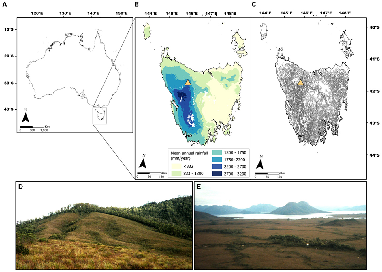
Figure 1. Map of study site: (A) map of Australia with black square indicating Tasmania; (B) Tasmania overlain by average annual rainfall isohyets showing the orographic rainfall gradient across the island and location of the Vale of Belvoir (yellow triangle) (data from Land Tasmania, 2022); (C) Tasmania overlain with 10 m contours and location of the Vale of Belvoir (yellow triangle) (data from Land Tasmania, 2022); (D) Typical buttongrass moorland and Nothofagus cunninghamii rainforest boundaries across the Vale of Belvoir (photo credit: Michael-Shawn Fletcher); (E) Buttongrass moorland vegetation and pockets of Eucalyptus spp. looking toward Lake Lea in the Vale of Belvoir (photo credit: Michael-Shawn Fletcher). For interpretation of the references to color in this figure legend, the reader is referred to the web version of this article.
The Vale of Belvoir is a subalpine valley in northwest Tasmania (41°32′22′′S, 145°53′16′′E; ~820 m a.s.l.) (Figure 1). The climate is cool and superhumid, characteristic of its location within the mountain ranges that bisect Tasmania from the northwest to the southeast. Moist westerly winds deliver rainfall to the region, which averages 2,353 mm per year (1995–2023 data from the nearest meteorological station at Cradle Mountain Visitor's Center; no. 96077; 41°36′0′′S, 145°55′48′′E; 810 m a.s.l.; 5.2 km southeast of the Vale) (Bureau of Meteorology, 2024). Mean seasonal temperatures in western Tasmania range between 5 and 7°C in winter and 14 and 16°C in summer (Bureau of Meteorology, 2019).
The valley extends in a northeast-southwest direction across approximately 20 km2. The local geology comprises of Tertiary basaltic volcanics underlain by Ordovician limestone and areas of Quaternary glacial deposits (Brown et al., 2021). Drainage is bi-directional; flowing northwards via the Lea River toward the Bass Strait and southwards via the Vale River into the Pieman River to the west coast. Vegetation across the Vale floor is dominated by rare and endangered treeless subalpine communities on basalt and limestone geology; highland Poa spp. tussock grassland and highland sedgy grassland (dominated by Poa gunnii and P. labillardierei), and subalpine Diplarrena latifolia rushland (Kitchener and Harris, 2013; Land Tasmania, 2022). Almost pure Gymnoschoenus sphaerocephalus Buttongrass Moorland forms on the nutrient poor and waterlogged areas underlain by Quaternary glacial deposits (Kitchener and Harris, 2013). The Vale has experienced extensive summer cattle grazing since the 1850s (Cubit, 1996) and in 2008, the Tasmanian Land Conservancy purchased the Vale of Belvoir, continuing summer cattle grazing in certain areas under lease (Tengia et al., 2016). The slopes of the Vale are dominated by patches of wet and dry Eucalypt-dominant forest and woodland, and discrete patches of Nothofagus cunninghamii-dominant rainforest. While able to regenerate following infrequent fire (Hill, 1982; Hill and Read, 1984; Prior et al., 2018), N. cunninghamii is generally fire-intolerant and stands are susceptible to complete mortality post-fire (Howard, 1973).
Palawa people have thrived in a dynamic island environment for more than 40,000 years (Cosgrove, 1990; Lehman, 2001; Fletcher and Thomas, 2010b; Cosgrove et al., 2014; Mariani et al., 2017; Romano and Fletcher, 2018; Fletcher et al., 2021a; Roberts et al., 2021). Their deep understanding and skillful manipulation of fire were central to their human ecology, shaping not only their survival, but also the very landscape they inhabited (Thomas and Kirkpatrick, 1996; Bowman, 1998; Gott, 2002; Fletcher et al., 2014, 2021a; Mariani et al., 2017; McWethy et al., 2017; Romano and Fletcher, 2018; Cooley et al., 2024). The unfortunate reality that Tasmania was declared “Aboriginal free” by 1836 (Lehman, 2001; Madley, 2008; Lawson, 2014; Brodie, 2017) means that an academic understanding of the human ecology of Palawa must principally rely on the ethnohistorical record that is often written by blinkered and biased Europeans who had long-cast Palawa as the lowest and “rudest type of man” (Gott, 2002, p. 652). Thomas (1992) compiled hundreds of accounts of Palawa fire use across almost every environment in Tasmania from ethnohistoric reports, concluding that, while the ethnohistoric record cannot be used to understand fire frequency or intensity with any great reliability, it is clear that fire was fundamental to the spiritual and economic lives of Palawa people.
Tasmania hosts diverse ecosystems, ranging from rainforests, through to temperate Eucalypt forests, grasslands and coastal regions (Kitchener and Harris, 2013). Palawa fire was essential in the creation and maintenance of the Tasmanian vegetation landscape, so much so that the distribution of Tasmanian vegetation can only be accounted for with an understanding of Palawa fire use (Brown and Podger, 1982; Bowman, 1998; Marsden-Smedley, 1998; Jackson, 1999; Fletcher and Thomas, 2010b; Mariani et al., 2017; McWethy et al., 2017; Adeleye et al., 2022; Henríquez et al., 2023; Cooley et al., 2024). Archaeological evidence points to a Late Pleistocene economy centered on the seasonal (summer) exploitation of wallaby and wombat drawn to inland glacial grasslands (Cosgrove, 1995; Pike-Tay et al., 2008; Roberts et al., 2021). While this Late Pleistocene economic model, proposed to describe the archaeological sequence of Tasmania's west, does not directly refence the “off-site” (i.e., wider local landscape) use of fire by Palawa (Cosgrove et al., 1990; Cosgrove, 1995), it is clear that Palawa were using fire to care for and manage their land at this time (Fletcher and Thomas, 2010a,b; Mariani et al., 2017; Henríquez et al., 2023; Cooley et al., 2024; Fletcher et al., in press). Fletcher and Thomas (2010a,b); Fletcher et al. (in press), and Henríquez et al. (2023) argue that Palawa attempted to maintain the open landscapes they first encountered 40,000 years ago by using fire. This use of fire by Palawa resulted in the failure of rainforest to recapture the landscape, as it had done repeatedly at the end of glacial phases prior to human arrival (Cooley et al., 2024). Instead, the most recent landscape of Tasmania's west became dominated by open vegetation reliant on fire application for the first time during an interglacial because of Palawa fire use (Fletcher and Thomas, 2010b).
In the east of Tasmania, regular burning by Palawa created the highly valued open forests and grasslands of the Midlands that were readily taken by settler farmers for grazing following the dispossession of Palawa (Ellis, 1985; Fensham, 1989; Thomas, 1992; Gammage, 2008). In the west, particularly the northwest—in the region of our study site—mid to high altitude (montane) Poa spp. grasslands exist where rainforest is typically the ecological climax vegetation (Ellis, 1985; Bowman et al., 2013; Kitchener and Harris, 2013; Fletcher et al., 2021a). Removal of Palawa burning by 1836 resulted in the loss of most of these grasslands to trees (Lehman, 2001; Gammage, 2008; Bowman et al., 2013; Fletcher et al., 2021a). Indeed, the renown botanist Roanld Gunn noted in 1860 (<30 years following the removal of Palawa from the region) that “a very considerable extent of the Surrey Hills [adjacent to our study site] is also becoming rapidly covered with forests of young Eucalypti... It was the same lower down the Leven and on the Hampshire Hills” (Rolls, 1999, p. 200). The effects of Palawa cultural burning on the vegetation of the northwest montane grassland-forest mosaic is one of key examples employed by archaeologist Jones (1969) in his seminal paper titled: Fire-Stick Farming—one of, if not the, most important academic assessments of the fire practices of Aboriginal people in Australia. In his groundbreaking work, Jones (1969) highlights the key role that Aboriginal fire use had in shaping the vegetation landscape of Australia. A fact captured by the notable surveyor Major Thomas Mitchell in 1848:
“Fire, grass, kangaroos, and human inhabitants seem all dependant on each other for existence in Australia…Fire is necessary to burn the grass and form those open forests, in which we find the large forest kangaroo; the native applies that fire to the grass at certain seasons, in order that a young green crop may subsequently spring up and so attract and enable him to kill or take the kangaroo with nets. In summer, the burning of the long grass also discloses vermin, birds' nests, etc., on which the females and the children who chiefly burn the grass, feed. But for this simple process, the Australian woods had probably contained as thick a jungle as those of New Zealand or America instead of open forests” (Jones, 1969, p. 6).
Additionally, ethnohistorical records also highlight the influence of Palawa cultural burning on mammals. Henry Hellyer, a British Surveyor who made detailed observations of the grasslands around the Vale of Belvoir, noted in 1828 that Palawa burning had created “a cultivated and diversified appearance and from its having being lately burnt in several extensive tracts, looking fresh and green in those places” (Thomas, 1992, p. 90). Hellyer went on to note that they “captured 3 remarkably fine kangaroo on the burnt ground close by, and the men declared on dissecting them that they had never seen any so fat before, which circumstance leads me to think there is something peculiar to this spot which causes the kangaroo to become so fat, and that the natives burn it off as they are aware of its qualities” (Thomas, 1992, p. 90). Moreover, the region's biodiversity of the land was dependent on Palawa cultural fire, with a positive correlation observed between fire and grassland diversity (particularly in the northwest) (Gilfedder, 1995). The dependency of Australian biodiversity on Aboriginal cultural fire has been reported elsewhere in Australia (e.g., Bird et al., 2004, 2005, 2016; Bliege Bird et al., 2020; Kelly et al., 2020), reflecting the deep and continuing relationship that Aboriginal people have had with Country for more than 40,000 years. The loss of Aboriginal cultural burning across Australia (including Tasmania) has seen an invasion by trees into grasslands (Rolls, 1981, 1999; Fletcher et al., 2021a; Mariani et al., 2021) and changes in species composition that threatens a huge component of Australia's biodiversity (McIntyre and Lavorel, 1994; Kirkpatrick, 1995; Rolls, 1999; Lunt, 2005; Williams and Morgan, 2015; Murphy and Leeuwen, 2021), further demonstrating the ubiquitous role of Aboriginal fire in creating, shaping and maintaining biodiverse Australian (and Tasmanian) environments.
Palawa fire use played (and continues to play) a central role in Palawa social and cultural spheres, extending beyond simply manipulating the environment for resource acquisition (Lehman, 2001; O'Kane et al., 2019). Burning was used for (among many other purposes) signaling, creating ceremonial grounds, cremations and crafting implements through fire hardening (Rose, 1996; Lehman, 2001; Aboriginal Heritage Tasmania, 2023). Palawa deliberately set fire to Country to produce (and protect) the type of Country that they wanted and that they were required to because of their relationship and obligation to Country (Lehman, 2001). Their spiritual connection to the land encompasses fire as well, with stories and rituals reflecting the significance of fire in their lives, highlighting the role of fire in shaping both the environment and their culture (Rose, 1996; Lehman, 2001; Aboriginal Heritage Tasmania, 2023). It is, thus, clear from the ethnohistorical record from Tasmania, along with Traditional Knowledge, ecological, anthropological, archaeological and geographical research from across Tasmania and Australia that Palawa (and all Aboriginal) fire use was a skilled, systematic, complex, nuanced and multi-faceted practice that was (and continues to be) central to their lifeways, and designed to fulfill a range of spiritual, pragmatic and economic objectives (Lehman, 2001; Bird et al., 2008; Gammage, 2011; David et al., 2024).
For this study we: (1) conducted vegetation analysis using geographic information systems (GIS); (2) collected tree cores from N. cunninghamii trees and; (3) collected sediment cores from across the dendrochronological transects. These cores were analyzed for pollen and charcoal to investigate changes in Palawa management pre- and post-British Invasion (ca. 1803). All selection of the results are presented as either violin plots or split violin plots (combining box-and-whisker plots with probability densities) using the R package ggplot2 v.3.4.1 (Wickham, 2016) and introdataviz v.0.0.0.9003 (Nordmann et al., 2022).
ASTER Global Digital Elevation Map (GDEM) (90 m resolution) (Robinson et al., 2014) and TASVEG 4.0 vector data (collected and supplied by the (Tasmanian) Department of Primary Industries, Parks, Water and Environment) were imported into ArcMap 10.3.1 and clipped to the Vale's extent (based on aerial imagery) (Figure 2A). Aspect data were calculated from the Aster GDEM and reassigned into four categorical variables: “north,” “south,” “east,” and “west.” TASVEG 4.0 vegetation data were also reclassified into two category types (based on forest type and dominant genera) to identify and isolate the vegetation of interest: “Nothofagus” and “Eucalyptus”. Non-assigned data (i.e., non-forest vegetation identified in the TASVEG 4.0 dataset) were removed from the analysis. Reclassified aspect data were then extracted and appended to the new vegetation attribute data using the “value-to-point” function in ArcMap 10.3.1. Ground-truthing of vegetation data was conducted in June 2016. Chi-squared significance tests (p < 0.001) were performed on the verified vegetation and aspect data to determine if a relationship between aspect and forest type exists at this site.
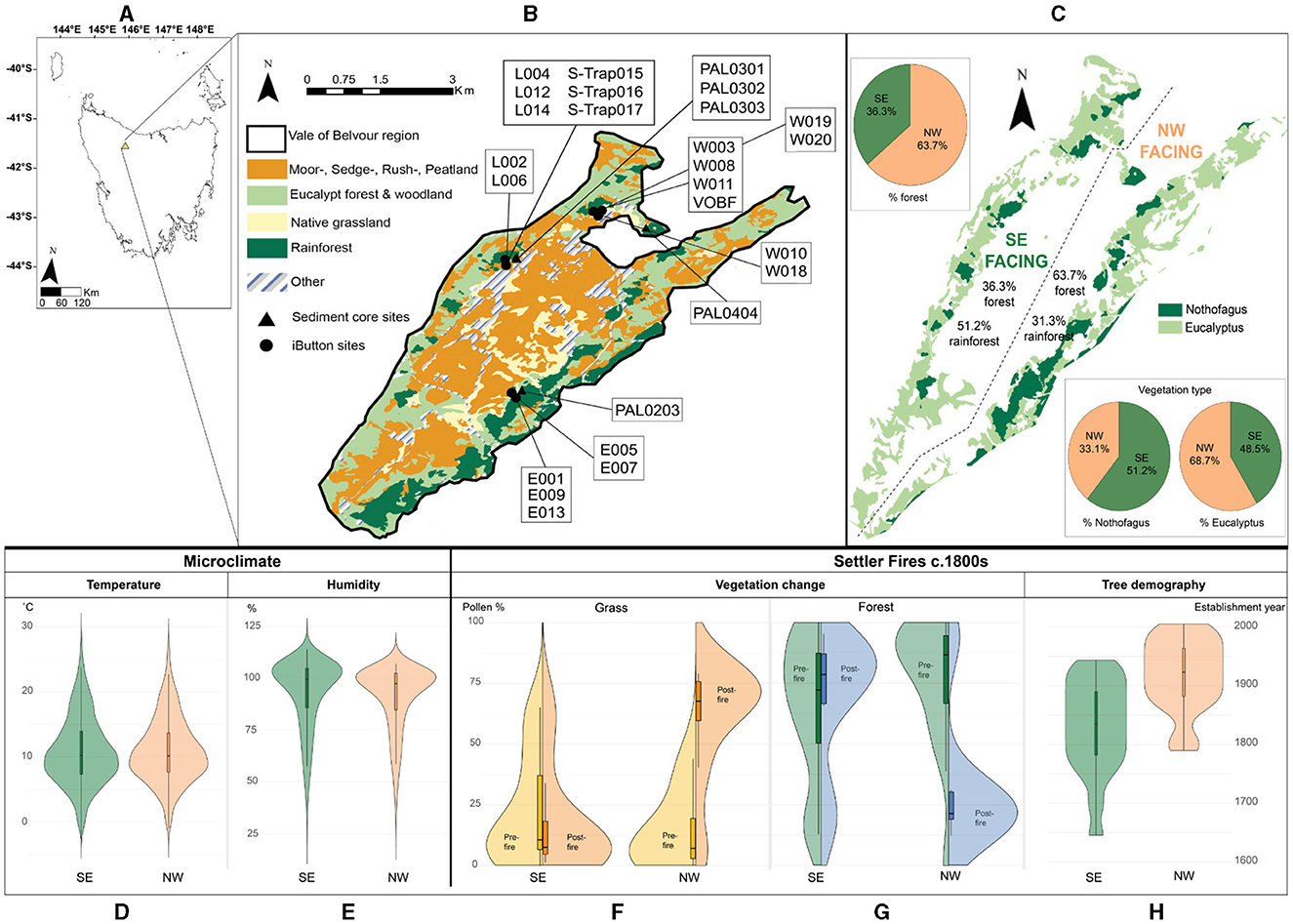
Figure 2. Summary of the datasets collected and analyzed for this study. (A) Map of Tasmania with the yellow triangle indicating the Vale of Belvoir study site; (B) map of the dominant vegetation groups of the Vale of Belvoir study area (data derived from TASVEG 4.0 avaliable from Land Tasmania, 2022) and locations of the iButton loggers and sediment core sites; (C) map of the results of the vegetation analysis isolating “Nothofagus” and “Eucalyptus”, pie chart inserts summarize percent forest and vegetation type according to aspect; (D) results of temperature data from southeast (green) and northwest (orange) iButton loggers presented as violin plots with degrees Celsius on the y-axis; (E) results of humidity data from southeast (green) and northwest (orange) iButton loggers presented as violin plots with percent humidity on the y-axis; (F) results of grassland sediment core sites response pre- (yellow) and post- (orange) a “fire event” on both the southeast and northwest facing aspects of our study area presented as split violin plots showing an increase in grass after a fire on the northwest facing aspects (G) results of forest sediment core sites response pre- (green) and post- (blue) a “fire event” on both the southeast and northwest facing aspects of our study area presented as split violin plots showing a decrease in forest after a fire on the northwest facing aspects (H) tree demography results from our study area presented as violin plots with establishment year on the y-axis. For interpretation of the references to color in this figure legend, the reader is referred to the web version of this article.
Twenty Hygrochron Temperature & Humidity loggers (DS1923-F5) (iButtons) were deployed in seven locations within the Vale (Figure 2B) to capture fine-scale variations in microclimate across the valley. In addition to being influenced by macroclimatic conditions, such as prevailing winds and average rainfall, microclimate is also affected by the influence of elevation, slope and aspect on local rainfall, wind strength and speed, insolation, cold air pooling, evapotranspiration, tree canopy cover, species composition, and water-source proximity and availability (Dobrowski, 2011). iButton locations were selected within a variety of topographic (elevation and aspect) and vegetation type (canopy cover and species composition) conditions (see Figure 2B). Two/three loggers were installed at each location to test the effect of shielding on the accuracy of the sensors. For further details of all loggers installed (and their precise locations) see Supplementary Table S1. Temperature and relative humidity data were collected every hour from the 28th October 2017 to 17th April 2018 (171 days) (encompassing the “fire season” in Tasmania).
Of the 20 iButton loggers deployed, 10 successfully yielded data. Loggers that failed were either located in open grassland, deployed without a shield, or may have been compromised by local fauna and/or extremes in temperature or humidity (Supplementary Table S1). Recovered data were downloaded and collated into vegetation type (open grassland, forest, heathland) and aspect [southeast (SE)- and northwest (NW)-facing] groups and averaged across each time-step for each climate variable. Final time-series data were analyzed using a two-sample t-test (assuming unequal variances) to determine significant difference (p < 0.05) between pairings of vegetation and aspect groups (Supplementary Table S2). Analyses were performed on both the full logged datasets and a subset of Tasmania's fire season (November 1st 2017 to 31st March 2018).
Tree establishment and dendrochronological analyses are widely used for investigations of disturbance dynamics in the absence of long-term historical records of forest composition and structural change (Ogden, 1978; Simkin and Baker, 2008; O'Donnell et al., 2010; Liebmann et al., 2016; Holz et al., 2020; Larson et al., 2021; Roos et al., 2021, 2022). Nothofagus cunninghamii produces reliable, annual growth rings and has been successfully used to understand forest demography (i.e., tree establishment) in both Tasmania (Read and Hill, 1985; Wood et al., 2010; Fletcher et al., 2021a) and Victoria (Simkin and Baker, 2008) and across other southern latitudes (Norton, 1984; Norton and Ogden, 1987; Lara et al., 2001; Venegas-González et al., 2018).
The establishment ages of trees were determined along transects from rainforest-grassland boundaries through to N. cunninghamii-dominant rainforest patches on each side of the Vale (northwest facing and southeast facing) (see Figures 2B, C). A third sample location was placed opportunistically around an anomalously large [diameter at breast height (dbh) 129.8 cm], relative to other trees within this forest patch (average dbh 7.8 cm), fire-scarred N. cunninghamii located within rainforest on the northwest-facing slope of the Vale. While this tree was too damaged to warrant sampling, we sampled within a 50 m radius around this fire-scarred tree to assess the age structure of what we assumed to be the smaller post-fire regeneration cohorts (based on the assumption that this species has a high mortality to catastrophic fire but can regenerate in the absence of subsequent disturbance) (Hill, 1982; Hill and Read, 1984; Prior et al., 2018). Two tree cores (taken at right angles) were extracted as close to the base of the tree as possible (e.g., ~40 cm) to capture the earliest years of growth (i.e., to capture the central ring) from each N. cunninghamii using a Haglof increment borer. Trees were selected using random stratified sampling (Simkin and Baker, 2008). The closest tree to the transect line was sampled continuously along the transect from N. cunninghamii dominated rainforest to rainforest-grassland edge. A total of 298 trees were counted from the three transects and included in this study as they reached the center of the tree. To obtain the most accurate establishment dates possible, tree cores were taken at or near the root crown. Cores were mounted, dried, and sanded prior to analysis using progressively finer grades of sandpaper (from 120 to 600 grit). Tree rings from individual tree cores were counted under an Olympus SZ51 dissecting microscope marking every 10th, 50th, and 100th ring. The number of tree rings counted in each core was assumed to represent the number of calendar years since the tree established (Simkin and Baker, 2008). The ages represent the time at which the trees reached sampling height and not the exact year of establishment (here this within 3–5 years of a seed's germination).
Sediment cores were retrieved from various locations along the base of the northwest and southeast facing slopes within the Vale (see Figure 2B; Table 1). Cores were extracted using a D-section peat sampler (Jowsey, 1966). Sediment coring locations were dictated by the availability of wetlands and other sediment sinks. PAL0301-0303 represent a transect of very small (<2 m across) bogs located across the rainforest-grassland boundary of the southeast-facing rainforest patch sampled for this study (see Section 3.3) (Figure 5B): PAL0301 (5 m inside the rainforest), PAL0302 (at the rainforest-grassland boundary), PAL0303 (15 m outside the rainforest in grassland). PAL0404 was extracted from an ephemeral pool (30 m diameter) located 25 m outside of a rainforest patch on the northwest-facing side of the Vale. PAL0203 was a small (5 m diameter) ephemeral pool located 5 m outside of a rainforest patch on the northwest-facing side of the Vale. VOBF core was extracted in the relative center of a N. cunninghamii rainforest patch on the southeast-facing slope of the Vale (Figure 2B).
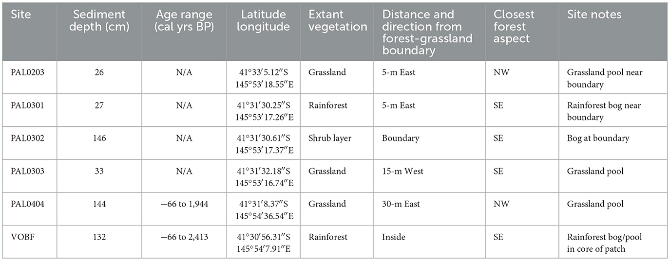
Table 1. Details of the sediment cores used in this study.
Seven radiocarbon dates were obtained and analyzed (four bulk sediment samples from PAL0404 and three bulk sediment samples from VOBF) (Table 3) at the DirectAMS 14C laboratory (Bothell, WA, USA). Raw radiocarbon ages were calibrated with the Southern Hemisphere calibration curve: SHCal20 (Hogg et al., 2020). A Bayesian age-depth model was developed in R v.4.2.3 (R Core Team, 2023) using the Bacon v.2.3.3 package (Blaauw and Christen, 2013) for PAL0404 and VOBF using default priors of 20 yr cm−1 and 1.5 for mean deposition time and shape. For this study we focus on the results from the two dated cores: PAL0404 and VOBF, with the other cores presented in Supplementary Figure S1.
We took 0.5 cm3 sediment samples from 1-cm thick sections at various intervals depending on the depth of the core for pollen analysis and processed following an adapted standard methodology (Faegri and Iversen, 1989). A minimum of 150 terrestrial pollen grains were identified per sample using a bright field objective at 400x magnification. Percentages were determined using the terrestrial pollen sum. Aquatic and spore pollen percentages were calculated from the supersum including all pollen and spores. Macroscopic charcoal was sampled (1.25 cm3) and processed at various intervals depending on the depth of the core using standard protocols (Whitlock and Larsen, 2001). Samples were digested with 10% hydrogen peroxide (H2O2), sieved using 125 and 250 μm mesh diameter and counted under a microscope. To understand broad changes in fire activity, irrespective of charcoal particle size and/or morphology, we calculated charcoal accumulation rates (CHAR, particles cm−2 yr−1) from charcoal counts using the results of the age-depth modeling for each dated core (P0404 and VOBF). To analyse the responses of forests and grasslands pre- and post- a “fire event” on both the southeast and northwest facing aspects of our study area, Eucalyptus spp. and N. cunninghamii pollen percentages from each core (see above) were summed to represent “Forest” and compared against the responses of Poaceae (representing grass). A “fire event” was deemed as the point of increase in each CHAR datasets. Forest and grass pollen percent datasets were then split, respectively, into pre-fire event and post-fire event.
To further highlight the influence of Palawa on the landscape in our study area we analyzed and utilized the limited Tasmanian archaeological radiocarbon record. Well-dated late Holocene archaeological sites are scarce in the study region and we rely on time-series radiocarbon data as a proxy for human activity (Peros et al., 2010; Ward and Larcombe, 2021). We acknowledge the limitations here of temporal distributions of past human archaeological activity (derived from radiocarbon data) primarily being affected by: (1) taphonomic biases (e.g., sedimentology, physical weathering, and erosion) and; (2) archaeological sampling and site formation processes (e.g., the natural and cultural forces that create an archaeological site) (Ward and Larcombe, 2021). For instance, in our study region, archaeological research is not evenly distributed nor are there expansive published records of sites identified within the time periods discussed in this paper. It is imperative to state that it cannot be concluded that areas and/or time periods without dates are devoid of human occupation/care for Country (the statement “absence of evidence is not evidence of absence” is particularly pertinent here). Our study region has been subject to very little to no systematic and/or thorough archaeological investigation (Cosgrove, 1990). Research almost exclusively has focused on coastal or cave sites with researchers erroneously suggesting that Palawa people were confined to the coast and rarely ventured inland in the northwest (Jones, 1966, 1971; Ryan, 1981; Cosgrove, 1990, 1999; Bowern, 2012; Cosgrove et al., 2014); although some studies have demonstrated archaeologically inland and highland occupation (mostly based on surveying i.e., without radiocarbon dates) (Cosgrove, 1984a,b, 1990). It is our intent here to provide the most comprehensive dataset on human activity available to date to help inform our data, it is not designed to provide a statistically robust estimate of human population dynamics for the region.
Here we contextualize inferred human archaeological activity with local geography and local-scale palaeo-environmental data to highlight the role of people (rather than relying on this dataset alone). Radiocarbon data were derived from the OCTOPUS Database v.2 (Saktura et al., 2021, 2023), selecting archaeological sites within northwest Tasmania [the “King,” “Tasmanian Central Highlands,” “Tasmania West,” and “Tasmanian Northern Slopes” Interim Biogeographic Regionalisation for Australia (IBRA) regions] (Supplementary Table S3; Supplementary Figure S2). This geographic constraint was employed to provide a representative subsample of the Tasmanian archaeological dataset from the northwest bioregion (sensu Romano and Fletcher, 2018). We removed radiocarbon dates based on marine samples (e.g., shells) that might be potentially affected by a reservoir effect [−123 ± 30 for molluscs (Ulm et al., 2023)]. The final sample size within the regions selected used for the analysis was 49 radiocarbon dates from 18 sites (Supplementary Table S3). Radiocarbon data was calibrated with SHCal20 (Hogg et al., 2020) using OxCal 4.4 (Ramsey, 2001) to obtain a weighted average value for each radiocarbon date (within 95.4% confidence) (Telford et al., 2004). To reduce the effect of “ascertainment” or “wealth” bias, calibrated dates were then “data binned” into 200-year intervals using R v.4.2.3 (R Core Team, 2023) based on the clustering of the weighted average calibrated dates to extract the main trends in the data and to equally weigh each site phase (Shennan et al., 2013; Kerr and McCormick, 2014; Timpson et al., 2014; Crema et al., 2016). Open sites within the dataset were corrected for taphonomic bias following the model outlined by Surovell et al. (2009) and applied following the methods in Peros et al. (2010). To estimate past human archaeological activity, the annual percentage growth rate (GRAnn) equation was applied to the resulting dataset (Peros et al., 2010; Romano and Fletcher, 2018; Friman and Lagerås, 2022).
Here we acknowledge the limitations of using a small dataset and the inability to successfully run more current approaches to human demography (see discussion in Supplementary material). However, we do not intend to interpret our results as “population size” but rather as processes of fission, fusion and diffusion; as shifts between localized and dispersed patterns of care for Country and intensity of occupation (Bevan et al., 2017; Bevan and Crema, 2021; Seidensticker et al., 2021; Tallavaara and Jørgensen, 2021; Crema, 2022).
Vegetation mapping of the Vale of Belvoir shows that forest vegetation accounts for 36.3% of the southeast-facing slopes of which 51.2% is Nothofagus-dominated rainforest (Figure 2C). On the other hand, northwest-facing slopes exhibit higher proportion of forest (63.7%), however only 33.1% is classified as Nothofagus-dominated rainforest (Figure 2C). Chi-square testing revealed a significant relationship between the proportion of rainforest and aspect (Table 2).
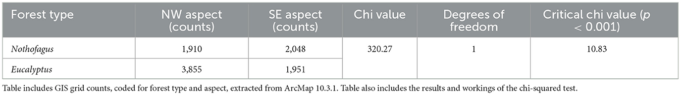
Table 2. Vegetation analysis results.
We recovered temperature and relative humidity data recorded during the fire season (NDJFM) from selected shielded loggers (E009, S-Trap017, L012, W003, W018) deployed in the Vale of Belvoir. Mean temperature and relative humidity measured in sites on the NW facing slopes are 10.9°C (min. −2.5°C, max. 29.1°C) and 91.7% (min. 27.6%, max. 107.1%), respectively. Sites on the SE facing slopes show mean temperature of 11.0°C (min. −2.6°C, max. 28.2°C) and mean relative humidity of 93.1% (min. 33.4%, max. 108.2%). We detected no significant difference (p > 0.05, using two-tailed homoscedastic t-test on 3,624 measurements in Excel) in temperature measurements between SE and NW facing slopes sites (Supplementary Table S2). We detected significant difference (p < 0.05, using two-tailed homoscedastic t-test on 3,624 measurements in Excel) in relative humidity between sites on NW and SE facing slopes (Supplementary Table S2), irrespective of the time-series analyzed. On average, humidity is significantly higher within forests on SE-facing slopes, with aspect exerting the greatest influence on average minimum humidity levels (27.6% on NW-facing compared to 33.4% on SE-facing slopes).
We also detected, for most sites, significant differences (p < 0.05; using two-tailed homoscedastic t-test on 3,624 measurements in Excel) in temperature and relative humidity between shielded and non-shielded loggers at the same site, indicating that shielding had a measurable effect on recorded microclimate data (Supplementary Table S1). Only temperature values measured within (20–35 m inside) rainforest patches recorded no significant effect of shielding, consistent with studies that identify evergreen tree cover as providing effective shielding (Lundquist and Huggett, 2008).
We performed dendrochronological analysis of N. cunninghamii trees along the SE- and NW-facing slopes in the Vale of Belvoir (Figure 2B). Our results reveal that the establishment year of N. cunninghamii trees over the SE-facing slopes range from 1650 to 1950 C.E, showing a rise in the number of trees after the arrival of graziers in the region in 1850 C.E. (from 37 trees pre-1850 to 71 trees post-1850) (Figures 2H, 3A). On northwest-facing slopes, the majority of N. cunninghamii trees established following the introduction of grazing in the Vale of Belvoir and broader region, with very few trees (only 3 on the NW-facing slopes pre-1850) pre-dating the British Invasion in 1788 C.E. (only 2 pre-ca.1803 British settlement of Tasmania, with 187 post-1850) (Figures 2H, 3A).
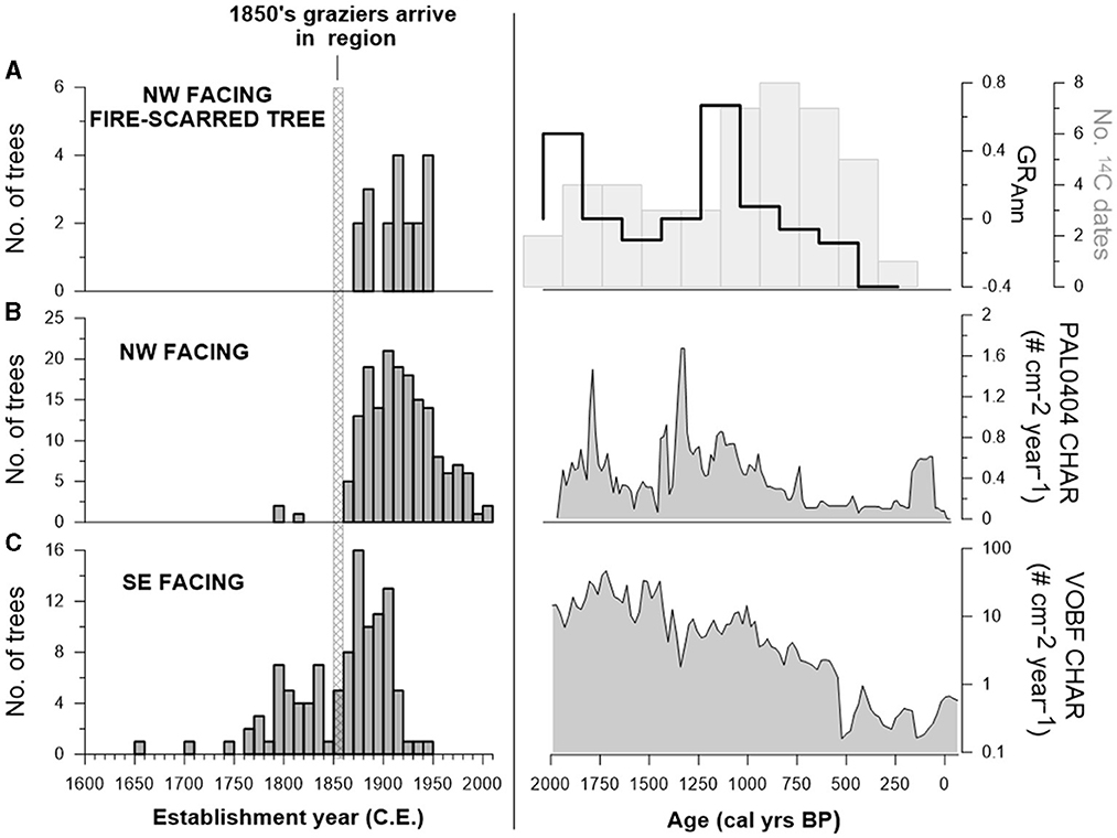
Figure 3. Results of dendrochronological, charcoal, and human estimate analyses. (A) Results of the tree demography across our study area with establishment year on the x-axis presented as common era years (C.E.) and the number of trees on the y-axis for the three sites: southeast-facing slopes, northwest-facing slopes, and northwest-facing slopes around the fire-scarred N. cunninghamii; (B) results of human activity estimates with calibrated years before present (cal yrs BP) on the x-axis, GRAnn (foreground; black solid line) on the first y-axis and number of 14C dates (background; gray bars) on the second y-axis; (C) results of macroscopic charcoal analyses presented as charcoal accumulation rates (CHAR, # particles cm−2 yr−1) with calibrated years before present (cal yrs BP) on the x-axis and CHAR on the y-axis; note VOBF CHAR is presented on a log10 y-axis to highlight the main trends in the record.
The sedimentary records from the sites PAL0404 and VOBF have a total length of 144 and 132 cm, respectively. The chronology of the PAL0404 site is constrained by 4 AMS radiocarbon dates (Table 3), with an interpolated basal age of 1969 calibrated years before present (cal yrs BP; present is defined as 1950) (Figure 4A) indicating that the sediment record spans almost two millennia cal yrs BP. The chronology of the VOBF site is constrained by 3 AMS radiocarbon dates (Table 3), showing an interpolated basal date of 2977 cal yrs BP suggesting that the sediment cores cover the last ~2500 cal yrs BP (Figure 4B).
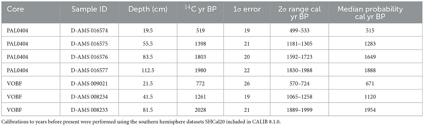
Table 3. Radiocarbon dates from cores PAL0404 and VOBF.
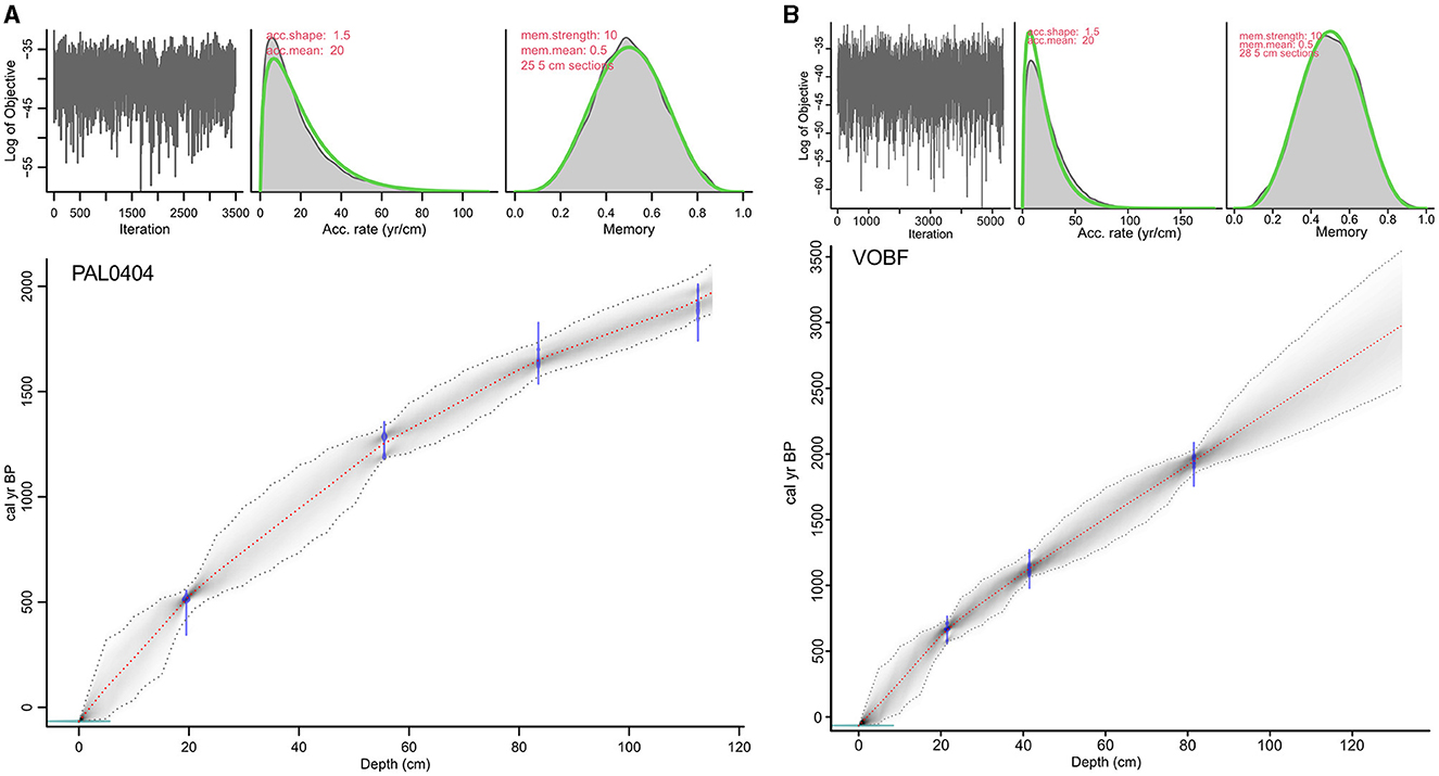
Figure 4. Bayesian age-depth model for core (A) PAL0404 and (B) VOBF. Modeling was performed using the rbacon package (Blaauw and Christen, 2013) in R. Purple indicates calibrated ages ranges for each radiocarbon-dated sample; red dashed line indicates the “best” model output based on the mean age for each depth; gray dashed line indicates 95% confidence intervals. Parameters and priors detailed in the top middle and top right plots for each age model. For interpretation of the references to color in this figure legend, the reader is referred to the web version of this article.
Visual increases (i.e., peaks) in charcoal are generally coincident with the introduction of exotic pastoral taxa (Rumex acetosella and Plantago lanceolata) to the valley, suggesting that fire activity recorded in PAL0203, PAL0301, and PAL0303 reflects burning at the time when livestock were introduced to the Vale (Supplementary Figure S1). On SE-facing slopes, where forest is dominated by N. cunninghamii, records (PAL0301, PAL0303) show that percentages of N. cunninghamii have remained relatively stable through the pre- and post-British Invasion. Interestingly, PAL0302 fails to record a charcoal signal in concert with the arrival of exotic pollen types. This might relate to the location of this small bog which was overtopped by shrubs (Richea spp.) on the boundary between forest and grassland, and the failure of fire to burn that location. In contrast, the fire events recorded at PAL0203 in the NW-facing side of the Vale, is associated with dramatic changes in vegetation—manifested principally as a fire-driven replacement of Eucalypt-forest by grassland.
The two dated cores show visually similar trends throughout the past ca. 1900 cal yrs BP (Figure 3C). Most notably, the period between ca 2000 and 800 cal yrs BP is marked by the highest levels of charcoal at each site (note VOBF accumulation rates are plotted on log10 scale), with both sites recording maximum CHAR peaks between this period (Figure 3B). Thereafter, both records are on a generally decreasing trend with lower values between ca. 500 and 150 cal yrs BP (Figure 3C). CHAR increases between ca. 150 and 50 cal yrs BP in PAL0404 and begins to increase at ca. 100 cal yrs BP in VOBF (Figure 3C) For our pollen data, we observe three significant CONISS zones in PAL0404 and two in VOBF from the percent terrestrial pollen taxa (Figure 5) (maximum percent values presented in parentheses).
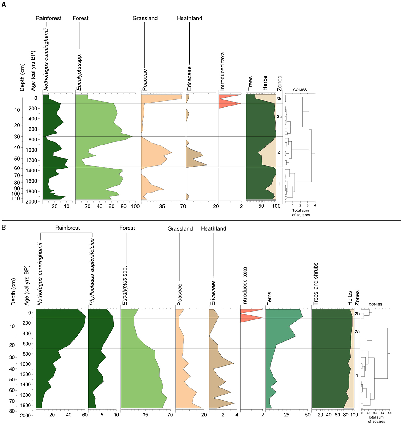
Figure 5. Summary pollen diagrams for (A) PAL0404 and (B) VOBF by depth (cm) and age (cal yrs BP). Three significant zones were determined for PAL0404 and two significant zones were determined for VOBF using CONISS on the terrestrial pollen data. Terrestrial pollen abundance was summed into two groups: trees & shrubs (green) and herbs (tan). Note the changes in x-scale (%). For interpretation of the references to color in this figure legend, the reader is referred to the web version of this article.
Zone 1 (~1955–1340 cal yrs BP; 114–60 cm) of the northwest-facing site, PAL0404, is dominated by Eucalyptus spp. (79.6%), with Poaceae (37.8%) replacing N. cunninghamii (min: 9.1%) (Figure 4A). In zone 2 (~1340–740 cal yrs BP; 60–30 cm) Eucalyptus spp. (min: 10%) is replaced by Poaceae (51.4%) and Ericaceae (14.7%) (Figure 5A). In zone 3a (~740–102 cal yrs BP; 30–6 cm) Eucalyptus spp. (95%) becoming dominant again, with decreases in Poaceae (1.9%) and Ericaceae (2%) (Figure 5A). This is until introduced taxa appear in Zone 3b (~102 cal yrs BP–present; 6–0 cm) (ca. 1848 CE) where Eucalyptus spp. reduce (20.4%) and Poaceae sharply increase (67.2%) (Figure 5A). N. cunninghamii remains consistently present throughout zones 2 and 3a (36.3%), with a decrease in Zone 3b (10.6%) (Figure 5A).
Zone 1 (~1858–749 cal yrs BP; 77–25 cm) of the southeast-facing site, VOBF, is dominated by Eucalyptus spp. (66%), herbaceous grassland taxa: Poaceae (18.7%) and heathland taxa Ericaceae (3.6%) (Figure 5B). Rainforest and fern taxa here remain comparatively low (>30.5 and >13.4%, respectively) (Figure 5B). In Zone 2a (~749–74 cal yrs BP–present; 25–10 cm) Eucalyptus spp. declines (24.8%), whilst rainforest taxa all increase: N. cunninghamii (60.8%) and Phyllocladus aspleniifolius (9.3%) alongside ferns (35.5%); herbaceous grassland and heathland taxa also decline (both >4%) (Figure 5B). When introduced taxa appear in Zone 2b (~74 cal yrs BP–present; 10–0 cm) (ca. 1876 CE) both rainforest taxa slightly decline (51.7 and 6.8%, respectively) alongside Ericaceae (1.4%) and Eucalyptus spp. and Poaceae increase (24.8 and 6, respectively) with a further stepped increase in ferns (43.8%) (Figure 5B).
The GRAnn estimate of the resulting archaeological radiocarbon dataset for this study ranges between −0.4 and 0.6% over the past ca. 2000 cal yrs BP. There are only two distinct positive phases in the GRAnn: one at ca. 1800 cal yrs BP and another between ca. 1000 and 600 cal yrs BP (Figure 3B). The bin-size is 200 years; this value was selected as it is slightly larger than double the median 14C error (91 years) for the entire dataset (Supplementary Table S3). The first increase in the frequency of dates beings ca. 1800 cal yrs BP decreasing slightly between ca. 1400 and 1200 cal yrs BP (Figure 3B). There is another phase of increased frequency between ca. 1000 and 600 cal yrs BP, decreasing thereafter (Figure 3B) Over 98% of the dates have errors of 200 years or less and 75% of the dates have errors of 100 years or less (Supplementary Figure S3). To maximize the sample size, we undertook all analyses using the complete, unfiltered set of archaeological radiocarbon dates.
Our data demonstrate that areas with a northwest (NW) aspect are systematically drier than those with a southeast (SE) aspect. Although the difference in measured subcanopy relative humidity between forests on the NW and SE facing slopes is small (Figures 2D, E), the importance of aspect over microclimate has had a profound influence over the impact of fire on the composition and long-term vegetation development in the local area. While having an overall higher forest cover due to the available area of suitable land (Figures 2B, C), fire adapted Eucalypt-forest dominates the forest vegetation on the NW facing slope, whereas the forested area on the SE facing slope is dominated by fire-sensitive rainforest (Figures 2B, C). The mechanism driving this local scale differentiation is disturbance by fire (Wood and Bowman, 2012; Cadd et al., 2019; Fletcher et al., 2020). In the absence of fire, rainforest is the ecological climax vegetation type in this high rainfall region on any substrate (Jackson, 1965, 1968; Bowman and Jackson, 1981; Fletcher et al., 2021a). North facing slopes receive more solar exposure than south facing slopes in the southern hemisphere, resulting in drier north-facing slopes relative to south facing slopes (Binkley and Fisher, 2019). Drier regions (e.g., north-facing slopes) experience either a higher fire frequency and/or more intense fires than southerly slopes, given the negative relationship between fuel moisture and flammability (Kirkpatrick and Dickinson, 1984; Marsden-Smedley and Catchpole, 2001; Bradstock et al., 2010; Wood et al., 2011; Wood and Bowman, 2012).
This interaction between aspect, topography, microclimate and fire is the mechanism that governs the distribution of rainforest across the high rainfall west of Tasmania today (Figure 1B) (Jackson, 1968; Wood et al., 2011). In a regional analysis of the distribution of rainforest in west and southwest Tasmania, Wood et al. (2011) identify that steep, south facing slopes have a higher probability of rainforest occurrence. This spatial pattern is driven by the effects of microclimate on fuel moisture and fire (Bradstock et al., 2010; Wood et al., 2010; Wood and Bowman, 2012). Wetter microclimates inhibit fire, while topography can also impact the spread of fire (Little et al., 2012; Sullivan et al., 2012; Leonard et al., 2014). The dominant westerly airflow over the region renders east-facing slopes more protected from fires fanned across the landscape from the west (Wood et al., 2011). Our data presented here are entirely consistent with the regional pattern identified by Wood et al. (2011), demonstrating that interactions between local-scale topography (i.e., topographic variation) and microclimate (variations in moisture and humidity) play an important role in the influence of fire and the distribution of forest at the local-scale across this region.
Our analysis of rainforest demography across the Vale, using dendrochronology, demonstrates that rainforest growing on the drier northwest facing slopes is younger than rainforest growing on the wetter southeast facing slope (Figures 2H, 3A). The age of all rainforest trees sampled on the northwest facing slope post-date the British Invasion into the region (ca. 1820s) (Figures 2H, 3A). In contrast, rainforest trees on the wetter southeast slope are systematically older and demonstrate a demography consistent with continual recruitment through the pre-and post-British Invasion era (Figures 2H, 3A). Early settlers were encouraged by the authorities to burn the Tasmanian landscape to remove forest and improve pastures, in stated recognition of what Palawa were doing on their lands (Marsden-Smedley, 1998). Burning by settlers was, as a result, widespread across Tasmania and also mainland Australia in an attempt to transform landscapes into more productive agricultural land (Cubit, 1996; Marsden-Smedley, 1998; Morgan et al., 2020). All of the trees surrounding the enormous fire-scarred N. cunninghamii tree observed within the rainforest on the northwest facing slope—which due to rot was undatable—also post-date the arrival of settlers to the area (Figure 3A), further supporting the notion that settlers attempted to remove the extant rainforest with fire. It also suggests that these efforts were abandoned, allowing the post-fire reestablishment of rainforest following the removal of rainforest.
While attempts to cultivate the Vale of Belvoir by settlers were short-lived, given the poor soils and seasonal snow cover, burning of the grasslands upon snow retreat and subsequent cattle grazing during the summer months has been occurring (and continues to occur) in the Vale since the 1850s (Cubit, 1996; Tengia et al., 2016). We interpret the close association between discrete charcoal peaks that appear in all pollen records [dated and undated, except for the core from within rainforest on the southeast facing slope (VOBF)] from across the Vale and the subsequent arrival of invasive pastoral weeds in the pollen records as further evidence of the attempt by settlers to remove forest in favor of grassland for livestock (Figures 3A, 5; Supplementary Figure S1). Indeed, they were encouraged, if not mandated, by the colonial authorities to do so (Marsden-Smedley, 1998). Our data demonstrate that this burning was effective in increasing grassy cover on the drier NW-facing slopes, but not on the wetter SE-facing slopes [see shifts in grass (Poaceae) and forest (Eucalyptus spp.) pre- and post-fire in Figures 2F, G; Supplementary Figure S1: PAL0203]. However, this effect was short-lived and followed by rainforest recovery (Figure 3A NW-facing sites) as the area was largely abandoned by settlers in favor of locations at lower altitude where livestock could be maintained year-round (Marsden-Smedley, 1998). Our data demonstrate that fire was ineffective in impacting rainforest on the wetter SE-facing slope (Figures 2F, G; Supplementary Figure S1), consistent with the effects of aspect and slope on fuel moisture and fire, as discussed above.
Our data suggest a close association between changes in fire, vegetation, aspect, climate and radiocarbon inferred Palawa activity in the northwest of Tasmania over the past 2000 years. While noting the caveats that must be considered when using radiocarbon ages as indicators of past human demography, particularly in the limited Tasmanian archaeological dataset, we observe two phases of increases in radiocarbon-inferred “activity” in the northwest of Tasmania between ca. 2000 and 800 cal yrs BP. This period is coeval with phases of persistent rainfall deficit (Saunders et al., 2012) and evidence for increased fire and the maintenance of fire-maintained vegetation in our dated sediment sequences from both the NW- and SE-facing slopes of the Vale (Figure 6). We interpret this confluence of data as reflecting an increased influence of Palawa care and management on the Vale during a phase of relative low rainfall (Figure 6). We contend that low rainfall in this area, that currently receives more than 2,500 mm of rain each year, allowed the manipulation of Eucalypt forest into more productive fire-maintained grassland on the drier NW-facing slope and the manipulation of rainforest to open Eucalypt forest on the wetter SE-facing slope (Figure 6). Indeed, both sites revert to more forested (both Eucalyptus spp. forest and rainforest) environments in concert with the evidence for decreased human activity and higher rainfall in the region (post ca. 800 cal yrs BP) (Figures 5, 6).
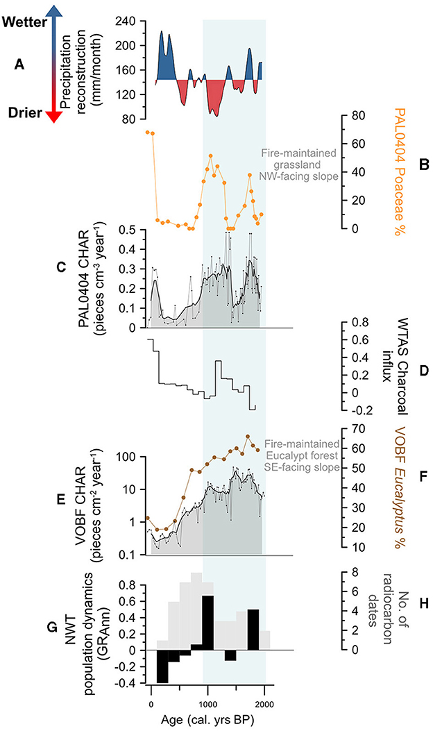
Figure 6. Summary plot of Vale of Belvoir data from this study. (A) Precipitation reconstruction (mm/month) from Rebecca Lagoon (41°11′S, 144°41′E) northwest Tasmania (Saunders et al., 2012), with higher than average shaded blue and lower than average shaded red; (B) PAL0404 Poaceae (grass %, orange); (C) PAL0404 macroscopic charcoal accumulation rate (Macroscopic CHAR, pieces cm−2/yr−1) (gray line) fitted with a weighted average (window width = 5) (solid black line and gray shading); (D) Western Tasmania charcoal influx curve calculated using the R package paleofire v.1.2.4 (Blarquez et al., 2014) updated to SHCal20 (Hogg et al., 2020) from sites outlined in Supplementary Figure S2 and Supplementary Table S4; (E) VOBF macroscopic charcoal accumulation rate (Macroscopic CHAR, pieces cm−2/yr−1) (gray line) fitted with a weighted average (window width = 5) (solid black line and gray shading); VOBF CHAR is presented on a log10 y-axis; (F) VOBF Eucalyptus spp. (%, brown); (G) northwest Tasmania human activity dynamics (GRAnn) (%, black line); (H) number of radiocarbon dated archaeological sites (gray shaded bars) used in the calculation of human activity estimates, see Supplementary Table S3 and Supplementary Figures S2, S3 for details of data used. For interpretation of the references to color in this figure legend, the reader is referred to the web version of this article.
The coherence between our data, palaeoclimate data and the archaeology of the northwest is consistent with what is known and documented about Palawa fire use: that Palawa used fire in a sophisticated and nuanced way to curate their land and that well-maintained and carefully curated grasslands were central to the economy of Palawa in areas where grasslands were able to be created (i.e., on fertile soils) (Thomas, 1992; Lehman, 2001). Lower rainfall in very wet regions like the Vale, we contend, allow an expansion of fire-based economic activity. The Vale and the northwest grasslands are one of the few areas in the west of Tasmania capable of supporting Poa spp. grasslands (most of the west is occupied by lower resource rich sedgelands on low productivity soils) (Kitchener and Harris, 2013). It is implausible that the Palawa did not exploit the persistent reduction lower rainfall to produce the fire-driven vegetation shifts toward more grass rich (i.e., resource rich) vegetation that we have identified in our proxy data, in what was and continues to be a highly valued region. Our data echoes what settlers documented across Tasmania (Thomas, 1992; Lehman, 2001), that burning Country was “desirable for [Palawa] as it affords them kangaroo, wombat and opossum…” (Hellyer, 1828; Thomas, 1992, p. 59). Indeed, the influence of Palawa burning on the northwest grasslands around the Vale was so influential that settler farmers sought to copy the Palawa practice of burning back with the snow-melt to sustain their livestock (Cubit, 1996).
Applying fire to create broadscale mosaics of vegetation was (and continues to be (Lehman, 2001; Bowman and French, 2019; Tasmania Parks Wildlife Service, 2022) practiced by Palawa to create what Hellyer observed in 1828 to be extensive “'grassy hills' which were adjacent to large tracts of rainforest” in northwest Tasmania, where “extensive areas of grassland existed in a broadscale mosaic with rainforest and tall stringybark forests (E. delegatensis)” (Thomas, 1992, p. 57). These quotes reflect the well-known fact that the grasslands of the northwest of Tasmania are Palawa artifacts produced by burning (Jones, 1969; Gammage, 2008; Onfray, 2012; Bowman et al., 2013; Fletcher et al., 2021a), adding weight to our assertion that the data we have presented here reflect a deliberate leveraging of climate to increase landscape productivity with fire during a period of low rainfall between ca. 2000 and 800 cal yr BP (Figure 6).
Our data from the Vale of Belvoir mirror the findings of a study from Rebecca Lagoon on the northwest coast of Tasmania, which demonstrated an increased effort by Palawa to care for their landscape in response to changes in rainfall between 2000 and 1000 cal yrs BP (Romano and Fletcher, 2018). Both the Vale of Belvoir data and the Rebecca Lagoon data demonstrate that Palawa were aware of and leveraged climatic change to modify their environment with fire (Figure 6). Rather than driving changes counter to what might be expected naturally, Palawa sought to exploit climatic change and their local environment to increase resource availability with fire by burning when moisture levels decreased in high-rainfall areas (Romano and Fletcher, 2018). Similar relationships between people and their environment have been observed elsewhere (e.g., Hoelzmann et al., 2001; Roos and Sullivan, 2010; Sullivan and Forste, 2014; Maezumi et al., 2018; Åkesson et al., 2020; Roos et al., 2022). It is clear that relegating the detection of human agency in records of past environmental change to when observed trends diverge from what is predicted naturally risks masking the deep and profound influence that people have had over the earth system.
In Australia, with some exceptions (e.g., Builth et al., 2008; Fletcher and Thomas, 2010b; Butler et al., 2014; Romano and Fletcher, 2018; Fletcher et al., 2021a), analyses of archaeological and palaeoenvironmental records generally fail to highlight the role of Aboriginal people in creating, caring for, and maintaining the Australian landscape over millennia (e.g., Mooney et al., 2011; Williams et al., 2015). Such studies routinely apply broad-scale (regional or continental-scale) environmental changes that operate at a spatiotemporal scale, which masks the local-scale and heterogeneous way in which people engage with their environments through time (Head, 2008, 2010). As such, people are subordinated to regional drivers, such as climate, and tenuous arguments are then made about the lack of human influence over the Australian continent (e.g., Bickford and Gell, 2005; Holdaway and Fanning, 2010; Holdaway et al., 2010; Mooney et al., 2011; Williams et al., 2015). This sets up a false binary where most studies into past human-environment dynamics through time position human agency as either perpetually in opposition to natural trends or as subordinate to natural trends (Head, 2010). Rarely is intelligence and proactiveness invoked to account for coherences between environmental and archaeological data.
Assuming human agency as singularly countering natural trends masks, or erases, people from the histories of their territories and allows the continuance of myths, such as “wild” and “wilderness” to describe cultural landscapes (Cronon, 1996; Langton, 1996; Nash, 2014; Watson et al., 2018b; Domínguez and Luoma, 2020; Fletcher et al., 2021b). This is particularly pertinent in places that have been shaped and maintained by people for long periods of time and where British and European invasions carried and perpetuated dehumanizing views of Indigenous and local peoples (Porter, 2014; Maezumi et al., 2018; Fletcher et al., 2021a; Larson et al., 2021; Roos et al., 2021). None are as pervasive as those espoused by Elkin (1933, p. 154, 1934) that Australian Aboriginal people were “parasites on nature” who “did not assist nature to produce his sustenance”. A racist and factually incorrect trope that echoes through to the present day in academia (Horton, 1982; Williams et al., 2015; Watson et al., 2018a,b) and in efforts to “rewild” the Australian “wilderness” (Sweeney et al., 2019). This trope is even more unfathomable when juxtaposed against the direct lived experience of Aboriginal people and the observations of people like Major Thomas Mitchell (Section 2.1), who engaged with the land and its people, that speak to the profound influence that Aboriginal people had over their land through the use of fire (Thomas, 1992).
“Wilderness/wild” is too often used to prop up false notions of naturalness in lands owned and occupied by Indigenous people for millennia (Martinez, 2003; Nash, 2014; Fletcher et al., 2021b). The removal of people from their lands, and their cultural obligations to their land, can have serious negative consequences for both the ecological integrity of their land and for the health of people (Stewart et al., 2002; Townsend et al., 2009; Porter, 2014; Fatima et al., 2023). Studies have shown that empowering Indigenous communities to care for their land has significant ecological, cultural and social benefits (Chino and DeBruyn, 2006; Townsend et al., 2009; Eriksen and Hankins, 2014; Mistry et al., 2016; Fatima et al., 2023; Dawson et al., 2024). Myths such as “wilderness” and “wild” incorrectly applied to cultural landscapes present barriers that stymie the development of appropriate care and management strategies for the environment that could benefit both people and their land (Rose, 1996; Shultis and Heffner, 2016; Fletcher et al., 2021b). While it has been demonstrated that Indigenous people who have autonomy in governing their land results in better human health and biodiversity outcomes (Schmidt and Peterson, 2009; Townsend et al., 2009; Baragwanath and Bayi, 2020; Baragwanath et al., 2023; Dawson et al., 2024; Simkins et al., 2024), power structures in settler-indigenous societies rarely permit that level of trust and agency (Snelgrove et al., 2014). In the absence of that trust and agency, a careful and nuanced understanding of past human-environment dynamics can provide an empirical basis to support Indigenous aspirations to return health to their land and people (Bird, 2004; West et al., 2006; Bird and Nimmo, 2018; Hoffman et al., 2021).
The original contributions presented in the study are included in the article/Supplementary material, further inquiries can be directed to the corresponding author.
M-SF: Writing – review & editing, Writing – original draft, Validation, Supervision, Resources, Project administration, Investigation, Funding acquisition, Formal analysis, Conceptualization. AR: Writing – review & editing, Writing – original draft, Methodology, Investigation, Formal analysis. SN: Writing – review & editing, Methodology, Investigation. WH: Writing – review & editing, Visualization, Methodology. MM: Writing – review & editing, Methodology. DJ: Writing – review & editing, Methodology, Investigation. AS: Writing – review & editing, Investigation.
The author(s) declare that financial support was received for the research, authorship, and/or publication of this article. This work was funded by the Australian Research Council projects: IN170100062, IN170100063, and IN210100055.
The authors declare that the research was conducted in the absence of any commercial or financial relationships that could be construed as a potential conflict of interest.
All claims expressed in this article are solely those of the authors and do not necessarily represent those of their affiliated organizations, or those of the publisher, the editors and the reviewers. Any product that may be evaluated in this article, or claim that may be made by its manufacturer, is not guaranteed or endorsed by the publisher.
The Supplementary Material for this article can be found online at: https://www.frontiersin.org/articles/10.3389/fearc.2024.1386339/full#supplementary-material
Åkesson, C. M., Matthews-Bird, F., Bitting, M., Fennell, C-, J., Church, W. B., Peterson, L. C., et al. (2020). 2100 years of human adaptation to climate change in the High Andes. Nat. Ecol. Evol. 4, 66–74. doi: 10.1038/s41559-019-1056-2
Adeleye, M. A., Haberle, S. G., Ondei, S., and Bowman, D. M. (2022). Ecosystem transformation following the mid-nineteenth century cessation of aboriginal fire management in Cape Pillar, Tasmania. Reg. Environ. Change 22:99. doi: 10.1007/s10113-022-01954-8
Adeleye, M. A., Mariani, M., Connor, S., Haberle, S. G., Herbert, A., Hopf, F., et al. (2021). Long-term drivers of vegetation turnover in southern hemisphere temperate ecosystems. Glob. Ecol. Biogeogr. 30, 557–571. doi: 10.1111/geb.13232
Archibald, S. (2016). Managing the human component of fire regimes: lessons from Africa. Philos. Transact. R. Soc. B Biol. Sci. 371:20150346. doi: 10.1098/rstb.2015.0346
Archibald, S., Staver, A. C., and Levin, S. A. (2012). Evolution of human-driven fire regimes in Africa. Proc. Nat. Acad. Sci. U. S. A. 109, 847–852. doi: 10.1073/pnas.1118648109
Baragwanath, K., and Bayi, E. (2020). Collective property rights reduce deforestation in the Brazilian Amazon. Proc. Natl. Acad. Sci. U.S.A. 117, 20495–20502. doi: 10.1073/pnas.1917874117
Baragwanath, K., Bayi, E., and Shinde, N. (2023). Collective property rights lead to secondary forest growth in the Brazilian Amazon. Proc. Natl. Acad. Sci. U.S.A. 120:e2221346120. doi: 10.1073/pnas.2221346120
Bevan, A., Colledge, S., Fuller, D., Fyfe, R., Shennan, S., and Stevens, C. (2017). Holocene fluctuations in human population demonstrate repeated links to food production and climate. Proc. Nat. Acad. Sci. U. S. A. 114, E10524–E10531. doi: 10.1073/pnas.1709190114
Bevan, A., and Crema, E. R. (2021). Modifiable reporting unit problems and time series of long-term human activity. Philos. Transact. R. Soc. B Biol. Sci. 376:20190726. doi: 10.1098/rstb.2019.0726
Bickford, S., and Gell, P. (2005). Holocene vegetation change, Aboriginal wetland use and the impact of European settlement on the Fleurieu Peninsula, South Australia. Holocene 15, 200–215. doi: 10.1191/0959683605hl800rp
Binkley, D., and Fisher, R. F. (2019). Ecology and Management of Forest Soils. Hoboken, NJ: John Wiley & Sons.
Bird, D. R. (2004). Reports From a Wild Country: Ethics for Decolonisation. Sydney, NSW: UNSW Press.
Bird, D. W., Bird, R. B., Codding, B. F., and Taylor, N. (2016). A landscape architecture of fire: cultural emergence and ecological pyrodiversity in Australia's Western Desert. Curr. Anthropol. 57, S65–S79. doi: 10.1086/685763
Bird, D. W., Bird, R. B., and Parker, C. H. (2005). Aboriginal burning regimes and hunting strategies in Australia's Western Desert. Hum. Ecol. 33, 443–464. doi: 10.1007/s10745-005-5155-0
Bird, D. W., Bliege Bird, R., and Parker, C. H. (2004). Women who hunt with fire: Aboriginal resource use and fire regimes In Australia's Western Desert. Aust. Aborig. Stud. 90–96.
Bird, R. B., Bird, D. W., Codding, B. F., Parker, C. H., and Jones, J. H. (2008). The “fire stick farming” hypothesis: Australian aboriginal foraging strategies, biodiversity, and anthropogenic fire mosaics. Proc. Nat. Acad. Sci. U. S. A. 105, 14796–14801. doi: 10.1073/pnas.0804757105
Bird, R. B., and Nimmo, D. (2018). Restore the lost ecological functions of people. Nat. Ecol. Evol. 2, 1050–1052. doi: 10.1038/s41559-018-0576-5
Blarquez, O., Vannière, B., Marlon, J. R., Daniau, A.-L., Power, M. J., Brewer, S., et al. (2014). Paleofire: an R package to analyse sedimentary charcoal records from the global charcoal database to reconstruct past biomass burning. Comput. Geosci. 72, 255–261. doi: 10.1016/j.cageo.2014.07.020
Bliege Bird, R., McGuire, C., Bird, D. W., Price, M. H., Zeanah, D., and Nimmo, D. G. (2020). Fire mosaics and habitat choice in nomadic foragers. Proc. Nat. Acad. Sci. U. S. A. 117, 12904–12914. doi: 10.1073/pnas.1921709117
Bowern, C. (2012). The riddle of tasmanian languages. Proc. R. Soc. B Biol. Sci. 279, 4590–4595. doi: 10.1098/rspb.2012.1842
Bowman, D. (1998). The impact of aboriginal landscape burning on the australian biota. New Phytol. 140, 385–410. doi: 10.1111/j.1469-8137.1998.00289.x
Bowman, D., and French, B. (2019). Our Land Is Burning, and Western Science Does Not Have All the Answers. Carlton, VIC: The Conversation Media Group Ltd.
Bowman, D., and Jackson, W. (1981). Vegetation succession in southwest tasmania. Search 12, 358–362.
Bowman, D., Murphy, B. P. B., Geoffrey, E., and Crisp, M. D. (2012). “Fire refimes and the evolution of the Australian Biota,” in Flammable Australia: Fire Regimes, Biodiversity and Ecosystems in a Changing World, eds. R. A. Bradstock, and A. M. Gill, and R. J. Williams (Collingwood, VIC: CSIRO Publishing), 27–48.
Bowman, D., Wood, S., Neyland, D., Sanders, G., and Prior, L. (2013). Contracting tasmanian montane grasslands within a forest matrix is consistent with cessation of a boriginal fire management. Austral Ecol. 38, 627–638. doi: 10.1111/aec.12008
Bowman, D. M., Balch, J., Artaxo, P., Bond, W. J., Cochrane, M. A., D'antonio, C. M., et al. (2011). The human dimension of fire regimes on earth. J. Biogeogr. 38, 2223–2236. doi: 10.1111/j.1365-2699.2011.02595.x
Bowman, D. M., Balch, J. K., Artaxo, P., Bond, W. J., Carlson, J. M., Cochrane, M. A., et al. (2009). Fire in the earth system. Science 324, 481–484. doi: 10.1126/science.1163886
Bradstock, R. A., Hammill, K. A., Collins, L., and Price, O. (2010). Effects of weather, fuel and terrain on fire severity in topographically diverse landscapes of South-Eastern Australia. Landsc. Ecol. 25, 607–619. doi: 10.1007/s10980-009-9443-8
Brodie, N. D. (2017). The Vandemonian War: The Secret History of Britain's Tasmanian Invasion. Richmond, VIC: Hardie Grant Books.
Brown, A. V., Calver, C. R., Corbett, M. J. C., Everard, K. D., Grace Cumming, J. L., Forsyth, S. M., et al. (2021). Geology of Tasmania Map 1:500 000. Rosny Park, TAS: Mineral Resources Tasmania.
Brown, M., and Podger, F. (1982). Floristics and fire regimes of a vegetation sequence from sedgeland-heath to rainforest at Bathurst Harbour, Tasmania. Aust. J. Bot. 30, 659–676. doi: 10.1071/BT9820659
Builth, H., Kershaw, A. P., White, C., Roach, A., Hartney, L., McKenzie, M., et al. (2008). Environmental and cultural change on the mt eccles lava-flow landscapes of southwest victoria, australia. Holocene 18, 413–424. doi: 10.1177/0959683607087931
Bureau of Meteorology (2019). Climate Statistics for Australian Locations. Available online at: http://www.bom.gov.au/climate/averages/tables/cw_097014.shtml (accessed March 14, 2024).
Bureau of Meteorology (2024). Monthly Rainfall: Cradle Mountain Visitors Centre. Available online at: http://www.bom.gov.au/jsp/ncc/cdio/weatherData/av?p_nccObsCode=139&p_display_type=dataFile&p_stn_num=096077 (accessed March 14, 2024).
Butler, D. W., Fensham, R. J., Murphy, B. P., Haberle, S. G., Bury, S. J., and Bowman, D. M. (2014). Aborigine-managed forest, Savanna and grassland: biome switching in montane eastern Australia. J. Biogeogr. 41, 1492–1505. doi: 10.1111/jbi.12306
Cadd, H., Fletcher, M. S., Mariani, M., Heijnis, H., and Gadd, P. S. (2019). The influence of fine-scale topography on the impacts of Holocene fire in a Tasmanian montane landscape. J. Quat. Sci. 34, 491–498. doi: 10.1002/jqs.3114
Carter, V. A., Brunelle, A., Power, M. J., DeRose, R. J., Bekker, M. F., Hart, I., et al. (2021). Legacies of indigenous land use shaped past wildfire regimes in the Basin-Plateau Region, USA. Commun. Earth Environ. 2:72. doi: 10.1038/s43247-021-00137-3
Chino, M., and DeBruyn, L. (2006). Building true capacity: indigenous models for indigenous communities. Am. J. Public Health 96, 596–599. doi: 10.2105/AJPH.2004.053801
Cooley, S., Fletcher, M. S., Lisé-Pronovost, A., May, J. H., Mariani, M., Gadd, P. S., et al. (2024). Rainforest response to glacial terminations before and after human arrival in Lutruwita (tasmania). Quat. Sci. Rev. 329:108572. doi: 10.1016/j.quascirev.2024.108572
Cosgrove, R. (1984a). Aboriginal Economy and Settlement in the Tasmanian Central Highlands (Occasional paper (Tasmania. National Parks and Wildlife Service) no. 8 0156–2797. National Parks and Wildlife Service.
Cosgrove, R. (1984b). “Aboriginal settlement patterns in the central highlands, Tasmania,” in Site Surveys and Significance Asessment in Australian Archaeology, eds. S. B. Sullivan, and S. Canberra (Canberra, ACT: Dept. of Prehistory, Research School of Pacific Studies, Australian National University).
Cosgrove, R. (1990). The Archaeological Resources of Tasmanian Forests: Past Aboriginal Use of Forested Environments. Occasional Paper Hobart. Department of Parks, Wildlife and Hertiage: Tasmania.
Cosgrove, R. (1995). Late pleistocene behavioural variation and time trends: the case from Tasmania. Archaeol. Ocean. 30, 83–104. doi: 10.1002/j.1834-4453.1995.tb00333.x
Cosgrove, R. (1999). Forty-two degrees south: the archaeology of late pleistocene Tasmania. J. World Prehistory 13, 357–402. doi: 10.1023/A:1022310029016
Cosgrove, R., Allen, J., and Marshall, B. (1990). Palaeo-ecology and pleistocene human occupation in South Central Tasmania. Antiquity 64, 59–78. doi: 10.1017/S0003598X00077309
Cosgrove, R., Pike-Tay, A., and Roebroeks, W. (2014). “Tasmanian archaeology and reflections on modern human behaviour,” in Southern Asia, Australia, and the Search for Human Origins, eds. M. Porr, and R. Dennell (Cambridge: Cambridge University Press), 175–188.
Coughlan, M. R., Magi, B. I., and Derr, K. M. (2018). A global analysis of hunter-gatherers, broadcast fire use, and lightning-fire-prone landscapes. Fire 1:41. doi: 10.3390/fire1030041
Crema, E. R. (2022). Statistical inference of prehistoric demography from frequency distributions of radiocarbon dates: a review and a guide for the perplexed. J. Archaeol. Method Theory 29, 1387–1418. doi: 10.1007/s10816-022-09559-5
Crema, E. R., Habu, J., Kobayashi, K., and Madella, M. (2016). Summed probability distribution of 14C dates suggests regional divergences in the population dynamics of the jomon period in Eastern Japan. PLoS ONE 11:e0154809. doi: 10.1371/journal.pone.0154809
Cronon, W. (1996). The trouble with wilderness: or, getting back to the wrong nature. Environ. Hist. Durh. N. C. 1, 7–28. doi: 10.2307/3985059
Cubit, S. (1996). ‘Burning back with the snow': traditional approaches to grassland management in Tasmania. Aust. Geogr. Stud. 34, 216–224. doi: 10.1111/j.1467-8470.1996.tb00117.x
David, B., Fletcher, M.-S., Connor, S., Pullin, V. R., Birkett-Rees, J., Delannoy, M., et al. (2024). Cultural Burning. Cambridge: Cambridge University Press.
Dawson, N. M., Coolsaet, B., Bhardwaj, A., Booker, F., Brown, D., Lliso, B., et al. (2024). Is it just conservation? A typology of indigenous peoples? and local communities? roles in conserving biodiversity. One Earth 7, 1007–1021. doi: 10.1016/j.oneear.2024.05.001
Dobrowski, S. Z. (2011). A climatic basis for microrefugia: the influence of terrain on climate. Glob. Chang. Biol. 17, 1022–1035. doi: 10.1111/j.1365-2486.2010.02263.x
Domínguez, L., and Luoma, C. (2020). Decolonising conservation policy: how colonial land and conservation ideologies persist and perpetuate indigenous injustices at the expense of the environment. Land 9:65. doi: 10.3390/land9030065
Dowdy, A. J. (2020). Climatology of thunderstorms, convective rainfall and dry lightning environments in Australia. Clim. Dyn. 54, 3041–3052. doi: 10.1007/s00382-020-05167-9
Dunbar, R. I. (2014). How conversations around campfires came to be. Proc. Nat. Acad. Sci.U. S. A. 111, 14013–14014. doi: 10.1073/pnas.1416382111
Ellis, R. (1985). The relationships among eucalypt forest, grassland and rainforest in a highland area In North-Eastern Tasmania. Aust. J. Ecol. 10, 297–314. doi: 10.1111/j.1442-9993.1985.tb00891.x
Eriksen, C., and Hankins, D. L. (2014). The retention, revival, and subjugation of indigenous fire knowledge through agency fire fighting in Eastern Australia and California. Soc. Nat. Resour. 27, 1288–1303. doi: 10.1080/08941920.2014.918226
Fatima, Y., Liu, Y., Cleary, A., Dean, J., Smith, V., King, S., et al. (2023). Connecting the health of country with the health of people: application of “caring for country” in improving the social and emotional well-being of indigenous people in Australia and New Zealand. Lancet Reg. Health West. Pac. 31:100648. doi: 10.1016/j.lanwpc.2022.100648
Fensham, R. (1989). The pre-european vegetation of the midlands, Tasmania: a floristic and historical analysis of vegetation patterns. J. Biogeog. 16, 29–45. doi: 10.2307/2845309
Fletcher, M.-S., Cadd, H. R., Mariani, M., Hall, T. L., and Wood, S. W. (2020). The role of species composition in the emergence of alternate vegetation states in a temperate rainforest system. Landsc. Ecol. 35, 2275–2285. doi: 10.1007/s10980-020-01110-9
Fletcher, M.-S., Hall, T., and Alexandra, A. N. (2021a). The loss of an indigenous constructed landscape following british invasion of Australia: an insight into the deep human imprint on the Australian landscape. Ambio 50, 138–149. doi: 10.1007/s13280-020-01339-3
Fletcher, M.-S., Hamilton, R., Dressler, W., and Palmer, L. (2021b). Indigenous knowledge and the shackles of wilderness. Proc. Nat. Acad. Sci. U. S. A. 118:e2022218118. doi: 10.1073/pnas.2022218118
Fletcher, M.-S., Romano, A., Connor, S., Mariani, M., and Maezumi, S. Y. (2021c). Catastrophic bushfires, indigenous fire knowledge and reframing science in Southeast Australia. Fire 4:61. doi: 10.3390/fire4030061
Fletcher, M.-S., Romano, A. L.-P., Mariani, M. H., William, P., Gadd, H. H., and Heijnis, D. (in press). Reconciling 22,000 Years of Landscape Openness in a Renowned Wilderness. Geographical Research.
Fletcher, M.-S., and Thomas, I. (2010a). A holocene record of sea level, vegetation, people and fire from Western Tasmania, Australia. Holocene 20, 351–361. doi: 10.1177/0959683609351903
Fletcher, M.-S., and Thomas, I. (2010b). The origin and temporal development of an ancient cultural landscape. J. Biogeogr. 37, 2183–2196. doi: 10.1111/j.1365-2699.2010.02363.x
Fletcher, M. S., Wolfe, B. B., Whitlock, C., Pompeani, D. P., Heijnis, H., Haberle, S. G., et al. (2014). The legacy of mid-holocene fire on a tasmanian montane landscape. J. Biogeogr. 41, 476–488. doi: 10.1111/jbi.12229
Folke, C., Carpenter, S., Walker, B., Scheffer, M., Elmqvist, T., Gunderson, L., et al. (2004). Regime shifts, resilience, and biodiversity in ecosystem management. Annu. Rev. Ecol. Evol. Syst. 35, 557–581. doi: 10.1146/annurev.ecolsys.35.021103.105711
Friman, B., and Lagerås, P. (2022). From neolithic boom-and-bust to iron age peak and decline: population and settlement dynamics in southern sweden inferred from summed radiocarbon dates. Eur. J. Archaeol. 26, 168–188. doi: 10.1017/eaa.2022.43
Gammage, B. (2008). Plain facts: Tasmania under aboriginal management. Landscape Res. 33, 241–254. doi: 10.1080/01426390701767278
Gammage, B. (2011). The Biggest Estate on Earth: How Aborigines Made Australia. Crow's Nest, NSW: Unwin.
Gilfedder, L. (1995). Montane Grasslands of North-Western Tasmania. Unpublished Report to North Forests Bumie and Forestry Tasmania. North Forests Bumie and Forestry Tasmania: Hobart, TAS.
Gott, B. (2002). Fire-making in Tasmania: absence of evidence is not evidence of absence. Curr. Anthropol. 43, 650–656. doi: 10.1086/342430
Gowlett, J. (2010). “Firing up the social brain,” in Social Brain and Distributed Mind, eds. R. Dunbar, C. Gamble, and J. Gowlett (London: The British Academy), 345–370.
Gowlett, J. A. (2016). The discovery of fire by humans: a long and convoluted process. Philos. Transact. R. Soc. B Biol. Sci. 371:20150164. doi: 10.1098/rstb.2015.0164
Gowlett, J. A., and Wrangham, R. W. (2013). Earliest fire in Africa: towards the convergence of archaeological evidence and the cooking hypothesis. Azania 48, 5–30. doi: 10.1080/0067270X.2012.756754
Greenwood, L., Bliege Bird, R., and Nimmo, D. (2021). Indigenous burning shapes the structure of visible and invisible fire mosaics. Landsc. Ecol. 7, 811–827. doi: 10.1007/s10980-021-01373-w
Head, L. (2008). Is the concept of human impacts past its use-by date? Holocene 18, 373–377. doi: 10.1177/0959683607087927
Head, L. (2010). Cultural ecology: adaptation-retrofitting a concept? Prog. Hum. Geogr. 34, 234–242. doi: 10.1177/0309132509338978
Hellyer, H. (1828). Letter From Hellyer to Curr. The Meston Papers no. M3/1/7. Hobart, RAS: University of Tasmania Archives.
Henríquez, W. I., Fletcher, M.-S., and Romano, A. (2023). Vegetation, fire and climate history in Central-Western Tasmania (41°s), australia, over the last ~21,000 years. Quat. Sci. Rev. 318:108315. doi: 10.1016/j.quascirev.2023.108315
Hill, R. S. (1982). Rainforest fire in Western Tasmania. Aust. J. Bot. 30, 583–589. doi: 10.1071/BT9820583
Hill, R. S. (2004). Origins of the southeastern australian vegetation. Philos. Transact. R. Soc. Lond. Ser. B Biol. Sci. 359, 1537–1549. doi: 10.1098/rstb.2004.1526
Hill, R. S., and Read, J. (1984). Post-fire regeneration of rainforest and mixed forest in western tasmania. Aust. J. Bot. 32, 481–493. doi: 10.1071/BT9840481
Hoelzmann, P., Keding, B., Berke, H., Kröpelin, S., and Kruse, H.-J. (2001). Environmental change and archaeology: lake evolution and human occupation in the eastern sahara during the holocene. Palaeogeogr. Palaeoclimatol. Palaeoecol. 169, 193–217. doi: 10.1016/S0031-0182(01)00211-5
Hoffman, K. M., Davis, E. L., Wickham, S. B., Schang, K., Johnson, A., Larking, T., et al. (2021). Conservation of earth's biodiversity is embedded in indigenous fire stewardship. Proc. Nat. Acad. Sci. U. S. A. 118:e2105073118. doi: 10.1073/pnas.2105073118
Hogg, A. G., Heaton, T. J., Hua, Q., Palmer, J. G., Turney, C. S., Southon, J., et al. (2020). Shcal20 southern hemisphere calibration, 0–55,000 years cal bp. Radiocarbon 62, 759–778. doi: 10.1017/RDC.2020.59
Holdaway, S. J., and Fanning, P. C. (2010). Geoarchaeology in Australia: understanding human-environment interactions. Geol. Soc. 346, 71–85. doi: 10.1144/SP346.6
Holdaway, S. J., Fanning, P. C., Rhodes, E. J., Marx, S. K., Floyd, B., and Douglass, M. J. (2010). Human response to palaeoenvironmental change and the question of temporal scale. Palaeogeogr. Palaeoclimatol. Palaeoecol. 292, 192–200. doi: 10.1016/j.palaeo.2010.03.043
Holz, A., and Veblen, T. T. (2011). The amplifying effects of humans on fire regimes in temperate rainforests in Western Patagonia. Palaeogeogr. Palaeoclimatol. Palaeoecol. 311, 82–92. doi: 10.1016/j.palaeo.2011.08.008
Holz, A., Wood, S. W., Ward, C., Veblen, T. T., and Bowman, D. M. (2020). Population collapse and retreat to fire refugia of the Tasmanian endemic conifer athrotaxis selaginoides following the transition from aboriginal to European fire management. Glob. Chang. Biol. 26, 3108–3121. doi: 10.1111/gcb.15031
Horton, D. (1982). The burning question: Aborigines, fire and australian ecosystems. Mankind 13, 237–252. doi: 10.1111/j.1835-9310.1982.tb01234.x
Horton, D. (2000). The Pure State of Nature: Sacred Cows, Destructive Myths and the Environment. Allen & Unwin. doi: 10.4324/97810031181
Howard, T. (1973). Studies in the ecology of Nothofagus cunninghamii Oerst. I. Natural regeneration on the Mt. Donna Buang Massif, Victoria. Aust. J. Bot. 21, 67–78. doi: 10.1071/BT9730067
Iglesias, V., and Whitlock, C. (2014). Fire responses to postglacial climate change and human impact in Northern Patagonia (41–43 s). Proc. Nat. Acad. Sci. U. S. A. 111, 5545–5554. doi: 10.1073/pnas.1410443111
Jackson, W. (1968). Fire, air, water and earth-an elemental ecology of Tasmania. Proc. Ecol. Soc. Aust. 3, 9–16.
Jackson, W. (1999). The Tasmanian legacy of man and fire. Pap. Proc. R. Soc. Tasmania 133, 1–14. doi: 10.26749/rstpp.133.1.1
Jackson, W. D. (1965). “Vegetation,” in Atlas of Tasmania, eds. J. L. Davies (Hobart, TAS: Land and Surveys Department), 30–35.
Jones, R. (1966). A speculative archaeological sequence for Northwest Tasmania. Rec. Queen Vict. Museum 25, 1–12.
Jowsey, P. C. (1966). An improved peat sampler. New Phytol. 65, 245–248. doi: 10.1111/j.1469-8137.1966.tb06356.x
Kelly, L. T., Giljohann, K. M., Duane, A., Aquilué, N., Archibald, S., Batllori, E., et al. (2020). Fire and biodiversity in the anthropocene. Science 370:eabb0355. doi: 10.1126/science.abb0355
Kerr, T. R., and McCormick, F. (2014). Statistics, sunspots and settlement: influences on sum of probability curves. J. Archaeol. Sci. 41, 493–501. doi: 10.1016/j.jas.2013.09.002
Kirkpatrick, J., and Dickinson, K. (1984). The impact of fire on Tasmanian alpine vegetation and soils. Aust. J. Bot. 32, 613–629. doi: 10.1071/BT9840613
Kirkpatrick, J. B. (1995). Australia's Most Threatened Ecosystem: The Southeastern Lowland Native Grasslands. Chipping Norton, NSW: Surrey Beatty & Sons in association with the World Wide Fund for Nature Australia.
Kitchener, A., and Harris, S. (2013). From Forest to Fjaeldmark: Descriptions of Tasmania's Vegetation. Hobart, TAS: Tasmania, Department of Primary Industries, Parks, Water and Environment.
Land Tasmania (2022). Land Information System Tasmania (List) Data. available online at: https://listdata.thelist.tas.gov.au/opendata/ (accessed May 5, 2023).
Langton, M. (1996). What do we mean by wilderness?: Wilderness and terra nullius in australian art [address to the Sydney Institute on 12 October 1995.]. Syd. Pap. 8, 10–31.
Lara, A., Aravena, J. C., Villalba, R., Wolodarsky-Franke, A., Luckman, B., and Wilson, R. (2001). Dendroclimatology of high-elevation Nothofagus pumilio forests at their northern distribution limit in the central Andes of Chile. Can. J. For. Res. 31, 925–936. doi: 10.1139/x00-208
Larson, E. R., Kipfmueller, K. F., and Johnson, L. B. (2021). People, fire, and pine: linking human agency and landscape in the boundary waters canoe area wilderness and beyond. Ann. Am. Assoc. Geogr. 111, 1–25. doi: 10.1080/24694452.2020.1768042
Lehman, G. (2001). “Turning back the clock: fire, biodiversity and indigenous community development in Tasmania,” in Working on Country: Indigenous Environmental Management in Australia, eds. R. Baker, J. Davies, and E. Young (South Melbourne, VIC: Oxford University Press), 308–319.
Leonard, S. W., Bennett, A. F., and Clarke, M. F. (2014). Determinants of the occurrence of unburnt forest patches: potential biotic refuges within a large, intense wildfire in south-Eastern Australia. For. Ecol. Manage. 314, 85–93. doi: 10.1016/j.foreco.2013.11.036
Liebmann, M. J., Farella, J., Roos, C. I., Stack, A., Martini, S., and Swetnam, T. W. (2016). Native american depopulation, reforestation, and fire regimes in the Southwest United States, 1492–1900 CE. Proc. Nat. Acad. Sci. U. S. A. 113, E696–E704. doi: 10.1073/pnas.1521744113
Little, J. K., Prior, L. D., Williamson, G. J., Williams, S. E., and Bowman, D. M. (2012). Fire weather risk differs across rain forest—savanna boundaries in the humid tropics of north-Eastern Australia. Austral Ecol. 37, 915–925. doi: 10.1111/j.1442-9993.2011.02350.x
Lundquist, J. D., and Huggett, B. (2008). Evergreen trees as inexpensive radiation shields for temperature sensors. Water Resour. Res. 44:6979. doi: 10.1029/2008WR006979
Lunt, I. D. (2005). Effects of Stock Grazing on Biodiversity Values in Temperate Native Grasslands and Grassy Woodlands in SE Australia: A Literature Review. Canberra, ACT.
Lynch, A. H., Beringer, J., Kershaw, P., Marshall, A., Mooney, S., Tapper, N., et al. (2007). Using the paleorecord to evaluate climate and fire interactions in Australia. Annu. Rev. Earth Planet. Sci. 35, 215–239. doi: 10.1146/annurev.earth.35.092006.145055
Madley, B. (2008). From terror to genocide: Britain's Tasmanian penal colony and Australia's history wars. J. Br. Stud. 47, 77–106. doi: 10.1086/522350
Maezumi, S. Y., Alves, D., Robinson, M., de Souza, J. G., Levis, C., Barnett, E. A., et al. (2018). The legacy of 4,500 years of polyculture agroforestry in the Eastern Amazon. Nat. Plants 4, 540–547. doi: 10.1038/s41477-018-0205-y
Mariani, M., Connor, S. E., Fletcher, M. S., Theuerkauf, M., Kuneš, P., Jacobsen, G., et al. (2017). How old is the tasmanian cultural landscape? A test of landscape openness using quantitative land-cover reconstructions. J. Biogeogr. 44, 2410–2420. doi: 10.1111/jbi.13040
Mariani, M., Connor, S. E., Theuerkauf, M., Herbert, A., Kune,š, P., Bowman, D., et al. (2021). Disruption of cultural burning promotes shrub encroachment and unprecedented wildfires. Front. Ecol. Environ. 20, 292–300. doi: 10.1002/fee.2395
Mariani, M., and Fletcher, M. S. (2016). The southern annular mode determines interannual and centennial-scale fire activity in temperate Southwest Tasmania, Australia. Geophys. Res. Lett. 43, 1702–1709. doi: 10.1002/2016GL068082
Mariani, M., Fletcher, M. S., Holz, A., and Nyman, P. (2016). Enso controls interannual fire activity in Southeast Australia. Geophys. Res. Lett. 10, 891–810, 900. doi: 10.1002/2016GL070572
Marlon, J. R., Bartlein, P. J., Carcaillet, C., Gavin, D. G., Harrison, S. P., Higuera, P. E., et al. (2008). Climate and human influences on global biomass burning over the past two millennia. Nat. Geosci. 1, 697–702. doi: 10.1038/ngeo313
Marlon, J. R., Bartlein, P. J., Gavin, D. G., Long, C. J., Anderson, R. S., Briles, C. E., et al. (2012). Long-term perspective on wildfires in the western USA. Proc. Nat. Acad. Sci. U. S. A. 109, 535–543. doi: 10.1073/pnas.1112839109
Marsden-Smedley, J. B. (1998). “Changes in Southwestern Tasmanian fire regimes since the early 1800s,” in Papers and Proceedings of the Royal Society of Tasmania (Hobart, TAS).
Marsden-Smedley, J. B., and Catchpole, W. R. (2001). Fire modelling in tasmanian buttongrass moorlands. III. Dead fuel moisture. Int. J. Wildland Fire 10, 241–253. doi: 10.1071/WF01025
Martinez, D. (2003). Protected areas, indigenous peoples, and the western idea of nature. Ecol. Restor. 21, 247–250. doi: 10.3368/er.21.4.247
McIntyre, S., and Lavorel, S. (1994). How environmental and disturbance factors influence species composition in temperate Australian grasslands. J. Veg. Sci. 5, 373–384. doi: 10.2307/3235861
McWethy, D., Haberle, S., Hopf, F., and Bowman, D. M. (2017). Aboriginal impacts on fire and vegetation on a Tasmanian island. J. Biogeogr. 44, 1319–1330. doi: 10.1111/jbi.12935
McWethy, D., Higuera, P., Whitlock, C., Veblen, T., Bowman, D., Cary, G., et al. (2013). A conceptual framework for predicting temperate ecosystem sensitivity to human impacts on fire regimes. Glob. Ecol. Biogeogr. 22, 900–912. doi: 10.1111/geb.12038
McWethy, D. B., Whitlock, C., Wilmshurst, J. M., McGlone, M. S., Fromont, M., Li, X., et al. (2010). Rapid landscape transformation In South Island, New Zealand, following initial polynesian settlement. Proc. Nat. Acad. Sci. U. S. A. 107, 21343–21348. doi: 10.1073/pnas.1011801107
Mercuri, A. M., Mazzanti, M. B., Torri, P., Vigliotti, L., Bosi, G., Florenzano, A., et al. (2012). A marine/terrestrial integration for mid-late holocene vegetation history and the development of the cultural landscape in the po valley as a result of human impact and climate change. Veg. Hist. Archaeobot. 21, 353–372. doi: 10.1007/s00334-012-0352-4
Mistry, J., Bilbao, B. A., and Berardi, A. (2016). Community owned solutions for fire management in tropical ecosystems: case studies from indigenous communities of South America. Philos. Transact. R. Soc. B Biol. Sci. 371:20150174. doi: 10.1098/rstb.2015.0174
Mooney, S. D., Harrison, S. P., Bartlein, P. J., Daniau, A. L., Stevenson, J., Brownlie, K. C., et al. (2011). Late quaternary fire regimes of Australasia. Quat. Sci. Rev. 30, 28–46. doi: 10.1016/j.quascirev.2010.10.010
Morgan, G., Tolhurst, K., Poynter, M., Cooper, N., McGuffog, T., Ryan, R., et al. (2020). Prescribed burning in South-Eastern Australia: history and future directions. Aust. For. 83, 4–28. doi: 10.1080/00049158.2020.1739883
Murphy, H., and Leeuwen, S. (2021). Australia State of Environment: Biodiversity. Canberra, VIC: Commonwealth of Australia; E. Department of Climate Change, the Environment and Water.
Nordmann, E., McAleer, P., Toivo, W., Paterson, H., and DeBruine, L. M. (2022). Data visualization using R for researchers who do not use R. Adv. Methods Pract. Psychol. Sci. 5:25152459221074654. doi: 10.1177/25152459221074654
Norton, D. (1984). Tree-growth-climate relationships in subalpine Nothofagus forests, South Island, New Zealand. N. Z. J. Bot. 22, 471–481. doi: 10.1080/0028825X.1984.10425281
Norton, D., and Ogden, J. (1987). Dendrochronology: a review with emphasis on New Zealand applications. N. Z. J. Ecol. 10, 77–95.
O'Donnell, A. J., Cullen, L. E., McCaw, W. L., Boer, M. M., and Grierson, P. F. (2010). Dendroecological potential of Callitris preissii for dating historical fires in semi-arid shrublands of Southern Western Australia. Dendrochronologia 28, 37–48. doi: 10.1016/j.dendro.2009.01.002
Oetelaar, G. A., and Meyer, D. (2006). Movement and native American landscapes: a comparative approach. Plains Anthropol. 51, 355–374. doi: 10.1179/pan.2006.030
Ogden, J. (1978). On the dendrochronological potential of Australian trees. Aust. J. Ecol. 3, 339–356. doi: 10.1111/j.1442-9993.1978.tb01184.x
O'Kane, M., Kojovic, N., Shanks, M., and Nurse, M. (2019). Re-invigorating cultural burning practices in Victoria. J. Anthropol. Soc. South Aust. 43, 71–93.
Onfray, R. (2012). “Cultural artefacts or ‘neglected old parks': the colonisation of rainforests in North-Western Tasmania,” in Australia's Ever Changing Forests VI: Proceedings of the Eighth National Conference on Australian Forest History (Canberra, ACT).
Pausas, J. G., and Keeley, J. E. (2009). A burning story: the role of fire in the history of life. Bioscience 59, 593–601. doi: 10.1525/bio.2009.59.7.10
Peros, M. C., Munoz, S. E., Gajewski, K., and Viau, A. E. (2010). Prehistoric demography of North America inferred from radiocarbon data. J. Archaeol. Sci. 37, 656–664. doi: 10.1016/j.jas.2009.10.029
Pike-Tay, A., Cosgrove, R., and Garvey, J. (2008). Systematic seasonal land use by late pleistocene tasmanian aborigines. J. Archaeol. Sci. 35, 2532–2544. doi: 10.1016/j.jas.2008.04.007
Porter, J. (2014). Native American Environmentalism: Land, Spirit, and the Idea of Wilderness. Lincoln, NE: University of Nebraska Press.
Power, M. J., Codding, B. F., Taylor, A. H., Swetnam, T. W., Magargal, K. E., Bird, D. W., et al. (2018). Human fire legacies on ecological landscapes. Front. Earth Sci. 6:151. doi: 10.3389/feart.2018.00151
Prior, L. D., French, B. J., and Bowman, D. M. (2018). Effect of experimental fire on seedlings of Australian and Gondwanan trees species from a Tasmanian montane vegetation mosaic. Aust. J. Bot. 66, 511–517. doi: 10.1071/BT18124
Ramsey, C. B. (2001). Development of the radiocarbon calibration program oxcal. Radiocarbon 43, 355–363. doi: 10.1017/S0033822200038212
Read, J., and Hill, R. S. (1985). Dynamics of Nothofagus-dominated rainforest on mainland Australia and lowland Tasmania. Vegetatio 63, 67–78. doi: 10.1007/BF00032607
Richardson, D., Black, A. S., Irving, D., Matear, R. J., Monselesan, D. P., Risbey, J. S., et al. (2022). Global increase in wildfire potential from compound fire weather and drought. NPJ Clim. Atmos. Sci. 5:23. doi: 10.1038/s41612-022-00248-4
Roberts, P., Buhrich, A., Caetano-Andrade, V., Cosgrove, R., Fairbairn, A., Florin, S. A., et al. (2021). Reimagining the relationship between gondwanan forests and aboriginal land management in Australia's “wet tropics”. Iscience 24:102190. doi: 10.1016/j.isci.2021.102190
Robinson, N., Regetz, J., and Guralnick, R. P. (2014). EarthEnv-DEM90: a nearly-global, void-free, multi-scale smoothed, 90m digital elevation model from fused ASTER and SRTM data. ISPRS J. Photogrammet. Remote Sens. 87, 57–67. doi: 10.1016/j.isprsjprs.2013.11.002
Rolls, E. (1999). Land of grass: the loss of Australia's grasslands. Aust. Geogr. Stud. 37, 197–213. doi: 10.1111/1467-8470.00079
Rolls, E. C. (1981). A Million Wild Acres: 200 Years of Man and an Australian Forest. Melbourne, VIC: Nelson.
Romano, A., and Fletcher, M.-S. (2018). Evidence for reduced environmental variability in response to increasing human population growth during the late holocene in northwest tasmania, australia. Quat. Sci. Rev. 197, 193–208. doi: 10.1016/j.quascirev.2018.07.001
Roos, C. I. (2020). Scale in the study of indigenous burning. Nat. Sustain. 3, 898–899. doi: 10.1038/s41893-020-0579-5
Roos, C. I., Guiterman, C. H., Margolis, E. Q., Swetnam, T. W., Laluk, N. C., Thompson, K. F., et al. (2022). Indigenous fire management and cross-scale fire-climate relationships in the Southwest United States from 1500 to 1900 CE. Sci. Adv. 8:eabq3221. doi: 10.1126/sciadv.abq3221
Roos, C. I., Sullivan, A. P. III, and McNamee, C. (2010). “Paleoecological evidence for systematic indigenous burning in the upland Southwest,” in The Archaeology of Anthropogenic Environments, Occasional Paper No. 37, ed. R. M. Dean (Center for Archaeological Investigations), 142–171.
Roos, C. I., Swetnam, T. W., Ferguson, T., Liebmann, M. J., Loehman, R. A., Welch, J. R., et al. (2021). Native American fire management at an ancient wildland–urban interface in the Southwest United States. Proc. Nat. Acad. Sci. U. S. A. 118:e2018733118. doi: 10.1073/pnas.2018733118
Roos, C. I., Williamson, G. J., and Bowman, D. M. (2019). Is anthropogenic pyrodiversity invisible in paleofire records? Fire 2:42. doi: 10.3390/fire2030042
Roos, C. I., Zedeño, M. N., Hollenback, K. L., and Erlick, M. M. (2018). Indigenous impacts on North American great plains fire regimes of the past millennium. Proc. Nat. Acad. Sci. U. S. A. 115, 8143–8148. doi: 10.1073/pnas.1805259115
Rose, D. B. (1996). Nourishing Terrains: Australian Aboriginal Views of Landscape and Wilderness. Canberra, ACT: Australian Heritage Commission.
Russell-Smith, J., Lucas, D., Gapindi, M., Gunbunuka, B., Kapirigi, N., Namingum, G., et al. (1997). Aboriginal resource utilization and fire management practice in western Arnhem Land, monsoonal northern Australia: notes for prehistory, lessons for the future. Hum. Ecol. 25, 159–195. doi: 10.1023/A:1021970021670
Saktura, W. M., Munack, H., Codilean, A. T., Wood, R., Petchey, F., Jacobs, Z., et al. (2021). Octopus Database V.2: The Sahularch Radiocarbon Collection. Sahul-Wide Database of Published Archaeological Records with Radiometric Ages. doi: 10.25900/2mb4-rr36
Saktura, W. M., Rehn, E., Linnenlucke, L., Munack, H., Wood, R., Petchey, F., et al. (2023). Sahularch: a geochronological database for the archaeology of Sahul. Aust. Archaeol. 89, 1–13. doi: 10.1080/03122417.2022.2159751
Saunders, K., Kamenik, C., Hodgson, D. A., Hunziker, S., Siffert, L., Fischer, D., et al. (2012). Late Holocene changes in precipitation in Northwest Tasmania and their potential links to shifts in the southern hemisphere westerly winds. Glob. Planet. Change 92, 82–91. doi: 10.1016/j.gloplacha.2012.04.005
Scheffer, M., Carpenter, S., Foley, J. A., Folke, C., and Walker, B. (2001). Catastrophic shifts in ecosystems. Nature 413, 591–596. doi: 10.1038/35098000
Scherjon, F., Bakels, C., MacDonald, K., and Roebroeks, W. (2015). Burning the land: an ethnographic study of off-site fire use by current and historically documented foragers and implications for the interpretation of past fire practices in the landscape. Curr. Anthropol. 56, 299–326. doi: 10.1086/681561
Schmidt, P. M., and Peterson, M. J. (2009). Biodiversity conservation and indigenous land management in the era of self-determination. Conserv. Biol. 23, 1458–1466. doi: 10.1111/j.1523-1739.2009.01262.x
Seidensticker, D., Hubau, W., Verschuren, D., Fortes-Lima, C., Maret, P. D. e., et al. (2021). Population collapse in Congo rainforest from 400 CE urges reassessment of the Bantu expansion. Sci. Adv. 7:eabd8352. doi: 10.1126/sciadv.abd8352
Shennan, S., Downey, S. S., Timpson, A., Edinborough, K., Colledge, S., Kerig, T., et al. (2013). Regional population collapse followed initial agriculture booms in mid-holocene europe. Nat. Commun. 4:2486. doi: 10.1038/ncomms3486
Shimelmitz, R., Kuhn, S. L., Jelinek, A. J., Ronen, A., Clark, A. E., and Weinstein-Evron, M. (2014). ‘Fire at will': the emergence of habitual fire use 350,000 years ago. J. Hum. Evol. 77, 196–203. doi: 10.1016/j.jhevol.2014.07.005
Shultis, J., and Heffner, S. (2016). Hegemonic and emerging concepts of conservation: a critical examination of barriers to incorporating indigenous perspectives in protected area conservation policies and practice. J. Sustain. Tour. 24, 1227–1242. doi: 10.1080/09669582.2016.1158827
Simkin, R., and Baker, P. J. (2008). Disturbance history and stand dynamics in tall open forest and riparian rainforest in the Central Highlands of Victoria. Austral Ecol. 33, 747–760. doi: 10.1111/j.1442-9993.2008.01843.x
Simkins, A. T., Donald, P. F., Beresford, A. E., Butchart, S. H. M., Fa, J. E., Fernández-Llamazares, A. O., et al. (2024). Rates of tree cover loss in key biodiversity areas on indigenous peoples' lands. Conserv. Biol. 38:e14195. doi: 10.1111/cobi.14195
Smith, B. D. (2007). The ultimate ecosystem engineers. Science 315, 1797–1798. doi: 10.1126/science.1137740
Snelgrove, C., Dhamoon, R., and Corntassel, J. (2014). Unsettling settler colonialism: the discourse and politics of settlers, and solidarity with indigenous nations. Decolon. Indigeneity Educ. Soc. 3, 1–32.
Stepka, Z., Azuri, I., Horwitz, L. K., Chazan, M., and Natalio, F. (2022). Hidden signatures of early fire at Evron Quarry (1.0 to 0.8 mya). Proc. Nat. Acad. Sci. U. S. A. 119:e2123439119. doi: 10.1073/pnas.2123439119
Stewart, O. C., Lewis, H. T., and Anderson, K. (2002). Forgotten Fires: Native Americans and the Transient Wilderness. Norman, OU: University of Oklahoma Press.
Stoeckl, N., Jarvis, D., Larson, S., Larson, A., and Grainger, D. (2021). Australian indigenous insights into ecosystem services: beyond services towards connectedness–people, place and time. Ecosyst. Serv. 50:101341. doi: 10.1016/j.ecoser.2021.101341
Sullivan, A. L., McCaw, W. L., Cruz, M. G., Matthews, S., and Ellis, P. F. (2012). “Fuel, fire weather and fire behaviour in Australian ecosystems,” in Flammable Australia: Fire Regimes, Biodiversity and Ecosystems in a Changing World, eds. R. J. Williams, A. M. Gill, and R. A. Bradstock (Collingwood, VIC: CSIRO Publishing), 51–77.
Sullivan, A. P., and Forste, K. M. (2014). Fire-reliant subsistence economies and anthropogenic coniferous ecosystems in the pre-columbian Northern American Southwest. Veg. Hist. Archaeobot. 23, 135–151. doi: 10.1007/s00334-014-0434-6
Surovell, T. A., Finley, J. B., Smith, G. M., Brantingham, P. J., and Kelly, R. (2009). Correcting temporal frequency distributions for taphonomic bias. J. Archaeol. Sci. 36, 1715–1724. doi: 10.1016/j.jas.2009.03.029
Sweeney, O. F., Turnbull, J., Jones, M., Letnic, M., Newsome, T. M., and Sharp, A. (2019). An Australian perspective on rewilding. Conserv. Biol. 33, 812–820. doi: 10.1111/cobi.13280
Swetnam, T. W., Farella, J., Roos, C. I., Liebmann, M. J., Falk, D. A., and Allen, C. D. (2016). Multiscale perspectives of fire, climate and humans in Western North America and the Jemez Mountains, USA. Philos. Transact. R. Soc. B Biol. Sci. 371:20150168. doi: 10.1098/rstb.2015.0168
Tallavaara, M., and Jørgensen, E. K. (2021). Why are population growth rate estimates of past and present hunter–gatherers so different? Philos. Transact. R. Soc. B 376:20190708. doi: 10.1098/rstb.2019.0708
Tasmania Parks and Wildlife Service (2022). Cultural Burning Policy. Hobart, TAS: Department of Natural Resources and Environment Tasmania.
Taylor, A. H., Trouet, V., Skinner, C. N., and Stephens, S. (2016). Socioecological transitions trigger fire regime shifts and modulate fire–climate interactions in the Sierra Nevada, USA, 1600–2015 CE. Proc. Nat. Acad. Sci. U. S. A. 113, 13684–13689. doi: 10.1073/pnas.1609775113
Telford, R. J., Heegaard, E., and Birks, B. H. J. (2004). The intercept is a poor estimate of a calibrated radiocarbon age. Holocene 14, 296–298. doi: 10.1191/0959683604hl707fa
Tengia, B., Taylor, M., and Kirkpatrick, J. (2016). Conservation tool or threatening process? Management implications of interactions of cattle with vegetation and land at the vale of belvoir reserve. Ecol. Manag. Restor. 17, 147–151. doi: 10.1111/emr.12204
Thomas, I. (1992). Ethnohistoric Sources for the Use of Fire by Tasmanian Aborigines: Preliminary Compilation and Investigation of the Evidence. Melbourne, VIC: Department of Geography and Environmental Studies, The University of Melbourne.
Thomas, I., and Kirkpatrick, J. (1996). The roles of coastlines, people and fire in the development of heathlands in Northeast Tasmania. J. Biogeogr. 23, 717–728. doi: 10.1111/j.1365-2699.1996.tb00032.x
Thompson, J. C., Wright, D. K., Ivory, S. J., Choi, J.-H., Nightingale, S., Mackay, A., et al. (2021). Early human impacts and ecosystem reorganization in Southern-Central Africa. Sci. Adv. 7:eabf9776. doi: 10.1126/sciadv.abf9776
Timpson, A., Colledge, S., Crema, E., Edinborough, K., Kerig, T., Manning, K., et al. (2014). Reconstructing regional population fluctuations in the European neolithic using radiocarbon dates: a new case-study using an improved method. J. Archaeol. Sci. 52, 549–557. doi: 10.1016/j.jas.2014.08.011
Townsend, M., Phillips, R., and Aldous, D. (2009). “If the land is healthy… it makes the people healthy”: The relationship between caring for country and health for the yorta yorta nation, boonwurrung and bangerang tribes. Health Place 15, 291–299. doi: 10.1016/j.healthplace.2008.05.009
Tran, B. N., Tanase, M. A., Bennett, L. T., and Aponte, C. (2020). High-severity wildfires in temperate australian forests have increased in extent and aggregation in recent decades. PLoS ONE 15:e0242484. doi: 10.1371/journal.pone.0242484
Ulm, S., O'Grady, D., Petchey, F., Hua, Q., Jacobsen, G., Linnenlucke, L., et al. (2023). Australian marine radiocarbon reservoir effects: Δr atlas and δr calculator for australian mainland coasts and near-shore islands. Radiocarbon 65, 1139–1159. doi: 10.1017/RDC.2023.95
Venegas-González, A., Juñent, F. R., Gutiérrez, A. G., and Filho, M. T. (2018). Recent radial growth decline in response to increased drought conditions in the northernmost Nothofagus populations from South America. For. Ecol. Manage. 409, 94–104. doi: 10.1016/j.foreco.2017.11.006
Ward, I., and Larcombe, P. (2021). Sedimentary unknowns constrain the current use of frequency analysis of radiocarbon data sets in forming regional models of demographic change. Geoarchaeology 36, 546–570. doi: 10.1002/gea.21837
Watson, J. E., Evans, T., Venter, O., Williams, B., Tulloch, A., Stewart, C., et al. (2018a). The exceptional value of intact forest ecosystems. Nat. Ecol. Evol. 2, 599–610. doi: 10.1038/s41559-018-0490-x
Watson, J. E., Venter, O., Lee, J., Jones, K. R., Robinson, J. G., Possingham, H. P., et al. (2018b). Protect the last of the wild. Nature 563, 27–30. doi: 10.1038/d41586-018-07183-6
West, P., Igoe, J., and Brockington, D. (2006). Parks and peoples: the social impact of protected areas. Annu. Rev. Anthropol. 35, 251–277. doi: 10.1146/annurev.anthro.35.081705.123308
Whitlock, C., and Larsen, C. (2001). “Charcoal as a fire proxy,” in Tracking Environmental Change Using Lake Sediments, eds. H. J. B. Birks, A. F. Lotter, S. Juggins, and J. Smol (Dordrecht: Springer Dordrecht), 75–97.
Williams, A. N., Mooney, S. D., Sisson, S. A., and Marlon, J. (2015). Exploring the relationship between aboriginal population indices and fire in Australia over the last 20,000 years. Palaeogeogr. Palaeoclimatol. Palaeoecol. 432, 49–57. doi: 10.1016/j.palaeo.2015.04.030
Williams, N., and Morgan, J. (2015). “The native temperate grasslands of South-Eastern Australia,” in Land of Sweeping Plains: Managing and Restoring the Native Grasslands of South-Eastern Australia, eds. N. Williams, A. Marshall, and J. Morgan (Clayton South, VIC: CSIRO Publishing), 61–86.
Wood, S., Hua, Q., Allen, K., and Bowman, D. (2010). Age and growth of a fire prone tasmanian temperate old-growth forest stand dominated by eucalyptus regnans, the world's tallest angiosperm. For. Ecol. Manage. 260, 438–447. doi: 10.1016/j.foreco.2010.04.037
Wood, S. W., and Bowman, D. M. (2012). Alternative stable states and the role of fire–vegetation–soil feedbacks in the temperate wilderness of Southwest Tasmania. Landsc. Ecol. 27, 13–28. doi: 10.1007/s10980-011-9677-0
Keywords: Indigenous Australia, cultural landscapes, fire, dendrochronology, palaeoecology, Tasmania
Citation: Fletcher M-S, Romano A, Nichols S, Henriquez Gonzalez W, Mariani M, Jaganjac D and Sculthorpe A (2024) Lifting the veil: pyrogeographic manipulation and the leveraging of environmental change by people across the Vale of Belvoir, Tasmania, Australia. Front. Environ. Archaeol. 3:1386339. doi: 10.3389/fearc.2024.1386339
Received: 15 February 2024; Accepted: 17 June 2024;
Published: 05 July 2024.
Edited by:
Christopher I. Roos, Southern Methodist University, United StatesReviewed by:
Michael R. Coughlan, University of Oregon, United StatesCopyright © 2024 Fletcher, Romano, Nichols, Henriquez Gonzalez, Mariani, Jaganjac and Sculthorpe. This is an open-access article distributed under the terms of the Creative Commons Attribution License (CC BY). The use, distribution or reproduction in other forums is permitted, provided the original author(s) and the copyright owner(s) are credited and that the original publication in this journal is cited, in accordance with accepted academic practice. No use, distribution or reproduction is permitted which does not comply with these terms.
*Correspondence: Michael-Shawn Fletcher, bWljaGFlbC5mbGV0Y2hlckB1bmltZWxiLmVkdS5hdQ==
Disclaimer: All claims expressed in this article are solely those of the authors and do not necessarily represent those of their affiliated organizations, or those of the publisher, the editors and the reviewers. Any product that may be evaluated in this article or claim that may be made by its manufacturer is not guaranteed or endorsed by the publisher.
Research integrity at Frontiers
Learn more about the work of our research integrity team to safeguard the quality of each article we publish.