 Yunhong Zhao
 Suruo Li1
 Yuhua Xu
- 1School of Computer Engineering, Jingchu University of Technology, Jingmen, China
- 2School of Finance, Nanjing Audit University, Nanjing, China
With the rapid development in the internet, cloud computing, Internet of Things, mobile internet, and other information technologies, the big data technology is widely used in all aspects of smart city construction. This study analyzes the development status of big data in urban planning and construction and studies the application of the big data technology in smart city construction. This study mainly analyzes and studies the aspects of smart city planning, smart transportation, smart community, smart health care, and smart education and finally puts forward relevant thoughts.
Introduction
Technology is changing rapidly, especially in areas such as mobile connectivity and artificial intelligence, as well as the rapid popularization of mobile intelligent terminals, and the data generated by all walks of life are growing explosively (Ying and lunlun, 2017; Ying-Hua, 2019). Effectively mining and using the value information implicit in “big data” have become the focus of research and attention of many experts (Zhao and Li, 2021). The construction of a “smart city” should rely on these innovative technologies to connect and integrate the various systems and services of the city (Ying and Qizhi; Zhao and Wu, 2021) and connect the real city with the digital city through collection, processing, and analysis of sea volume data in the real city so as to optimize urban management (Minaei, 2021; Zhang et al., 2022), improve the utilization efficiency of resources, provide smart services for urban residents, and improve the quality of life.
Current Situation of Urban Planning and Management
The legal system needs to be further improved, and the urban planning management is not standardized. The requirement of administrative laws in the field of urban planning is to regulate a series of administrative acts, including abstract administrative acts and specific administrative acts, such as organization, compilation, approval, implementation, supervision, and inspection of urban planning. In view of the current situation of urban planning legislation in China, there are no procedures for planning approval such as tendering, government procurement, time limit, public announcement, hearing, and adjustment. Many of these problems are caused by the imperfection of China’s administrative procedure legislation.
For urban planning in our country, the decision-making power of urban planning seems to belong to government leaders and planning experts, and urban planning seems to be increasingly far from the public eye, making it difficult to ensure the validity and rationality of urban planning. Local governments and departments have too much planning discretion in the course of urban planning management (Sun and Tang, 2021). Planners and the public are only the executors and implementers of urban planning decisions, which are not conducive to the restriction and supervision of urban planning management activities. At this time, urban planning decision is far from the original purpose and goal of urban planning and not conducive to the long-term healthy development of the city.
Theories and Methods in Traditional Urban Management and Planning
In 1898, Ebenezer Howard, an Englishman, put forward the theory of “pastoral city” (Chai et al., 2021; Tania et al., 2021). As a result of his research, he has written a book, Tomorrow: A Path to Peace for Real Reform, which aims to radically improve the urban form of capitalism (Yaghoob et al., 2021), pointing out the contradiction between cities and liveability in industrialized conditions and between large cities and natural segregation.
Howard’s theory (Jasmina, 2021) studies the city as a whole, links the relationship between urban and rural areas, puts forward the urban planning problems which adapts to the modern industry, and puts forward the point of view of population density, urban economy, and the importance of urban greening, which plays an important role in the construction of urban planning discipline. Today’s planning circles generally agree that Howard’s proposal’s “idyllic city” was the beginning of modern urban planning (Gao et al., 2021; Prakash et al., 2021).
At the beginning of the 20th century, the vicious expansion of large cities made controlling and evacuating the population of large cities a prominent problem. Howard’s theory of the “garden city” was further developed by his follower Unwin (Liu and Gao, 2021) into a theory of satellite cities around large cities to evacuate people and control the size of large cities. A theoretical solution was proposed in 1922. At the same time, Wheaton, the American planner, proposed to surround the big cities with green space, limit their growth, create satellite towns outside of green space, build industrial enterprises, and maintain some connection to big cities (Lavalle et al., 2020).
Current Situation of Smart City Construction: New Data Environment and Quantitative Urban Research
Throughout the development history of urban science, from the recording and description of urban phenomena to the induction and summary of urban phenomena, to the description of the relationship between urban things, and finally to the perspective of systems and even complex systems, its development process has experienced a process from qualitative to quantitative. Under the background of the gradual transformation of China’s urban planning from “large-scale demolition and construction” in the past 2 or 3 decades to fine planning and management, quantitative urban research has attracted more and more attention. At the same time, the progress and popularization of the information and communication technology in recent years have provided a large number of new data sources for quantitative urban research, including not only big data in the strict sense but also open data from commercial websites and government departments, which together constitute an important basis for understanding the operation law of the urban system. It also promotes various changes in research methods and research issues in the field of quantitative urban research. This study attempts to sort out and summarize several main reform trends of quantitative urban research in China and put forward some thoughts on issues related to discipline development, hoping to attract the attention and further research of domestic academic circles.
New Data Environment
With the rapid development in artificial intelligence (AI), cloud computing, Internet of Things (IOT), blockchain, and 5 g (Xiang, 2020), the data which are generated by mobile terminals, e-commerce, RFID, and face recognition and other application scenarios are increasing every day. Accordingly, more and more network applications are widespread based on the P2P network technology, such as the search engine, short video, and social media, and are increasing in large quantities (Popescu et al., 2020). It can be said that the data generated by mankind in recent years are more than the total data generated by mankind in history, which is no exaggeration; the amount of data generated in the world every day is as high as 2.5 exabyte (EB, 260); this kind of high-capacity, high-speed diversified big data streams are increasingly becoming the focus of attention in China’s planning academic circles (Li and Han, 2020). In fact, the databases on urban researchers are expanding, including government open data, open-source low-value commercial data, and voluntary geographic information that facilitate smart cities and people’s livelihood services. The data environment composed of this information is significantly unique compared with the traditional data. These data have the characteristics of high precision, wide range, and fast update. Specifically, the data is one unit based on individuals or facilities. The data are not limited by administrative regions, and they are updated all the time. This not only means that the amount of data itself is huge but also reflects the related hidden information, including personal behavior information, mobile information, and communication information. The concept of urban planning in the period of new urbanization is people-oriented, stock renewal, and bottom-up. Being people-oriented means that in the process of urban development, people come first, and urban planning and development take people as the starting point. In contrast, it takes things as the primary focus. This is an early development concept in the process of urban development, which often ignores human factors. Stock renewal refers to the transformation and upgrading based on existing resources in the process of urban planning, construction, and governance, so as to avoid new and abolished reconstruction as far as possible. The opposite is incremental development. The bottom-up development concept means that the driving force in the process of urban development comes from the ordinary people at the lower level rather than from the upper orders of the country. The opposite is the top-down concept. The new data environment is a powerful tool to promote efficient urban governance and scientific planning. Undoubtedly, whether it is academic research, planning practice, or business consulting, it is a breakthrough development opportunity (Qian and Li, 2020).
Quantitative Urban Researches
Quantitative urban studies (Ahmad, 2021) are a scientific research method, which is compared with qualitative urban research to explore the general rule of urban development by a great variety of data, scientific means, and mathematical tools on a certain urban theoretical basis. It quantifies the problems and phenomena in urban planning and then analyses, tests and explains them so as to obtain meaningful urban planning research methods and processes. Quantitative urban research is to measure and obtain data based on digital symbols. By comparing the characteristics of the research object according to a certain standard, we can measure the characteristic value of the object or find the variation law of the quantity between some factors. It can be applied to support the analysis of the current situation of urban and rural planning at various stages such as urban scheme establishment, implementation, supervision, and evaluation. For the current quantitative urban research, the biggest difference is not only the traditional planning informatization or the application of the new planning technology but also more focused on the comprehensive, intuitive, and objective analysis of urban phenomena (Dowling et al., 2021); thereafter, the analysis results are given feedback to urban managers department, policymakers, experts, scholars, planners, and urban residents through various interactive formats, such as media and network, and then, its scientificity is improved in the process of urban planning and related policymaking from various aspects.
In the current academic circles of western developed countries, it has become a research hotspot to analyze urban space and crowd activity in a new data environment. A large number of studies can be preliminarily summarized into seven types, as shown in Table 1. To sum up, the relevant research highlights three characteristics. After all, the research tends to be scattered, that is, compared with the comprehensive analysis of the urban system, there is much more local analysis of a specific aspect of urban phenomenon, which is related to the characteristics of the new data environment because its essence is large amount of data, high precision, and few dimensions. Second, both the analysis and algorithm tend to be simplified, that is, interesting and meaningful analysis results can be obtained through a simple statistical analysis of time, space, and attribute levels. Third, it focuses more on the judgment and analysis of current problems than the prediction or simulation of the future.
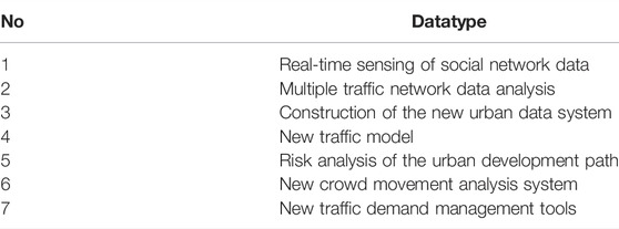
TABLE 1. New data environment for urban space and crowd activity analysis.
At present, some representative quantitative urban research is carried out in China using the new data environment which includes the following: using bus card swiping records to study commuting travel, urban poverty, excessive commuting, and the spatial structure of bus commuting; using mobile signaling data to study urban population distribution, spatial structure, the influence of business district, travel distance of residents, etc.; using taxi GPS data to predict the location of congestion; analyzing the temporal and spatial characteristics of daily activities of suburban residents by using GPS data; using social network location data and sign-in information to study the function and mixing degree of urban land, urban development boundary, division of the urban activity area, and spatial structure of urban network information; using the Baidu Index to study the characteristics of the regional urban network; using Baidu and Gaode migration data to study the urban system and residents’ Golden Week tourism behavior; using public comment data to study the pattern of the catering industry and restaurant location; using the online data of national PM2.5 monitoring to study the distribution of PM2.5 pollution; and the use of microscale demographic data to analyze China’s urban pattern. In addition, due to China’s weak open data foundation, limited data coverage (for example, the spatial data opened by the government are mostly for one city), and the lack of unity and horizontal comparison between cities and regions, an important work of current quantitative city research is to extract and summarize open data nationwide. The representative data and research results include the following: 1) collecting and spatializing the land use planning maps of more than 200 cities across the country and preliminarily synthesizing the “national land use planning map” so as to preliminarily evaluate the spatial consistency between the actual development and planning of each city in the process of rapid urbanization; 2) collecting the census data of townships, towns, and sub-district offices in municipalities directly under the central government, provinces, cities and autonomous regions and then studying the population density and its temporal and spatial evolution at the sub-district level of townships and towns; 3) obtaining the daily and hourly PM2.5 concentration data and daily aerosol (MODIS AOD) remote sensing images of all monitoring stations in China in 2020, establishing a national PM2.5 concentration map at the Township street scale, and evaluating the corresponding population exposure; 4) obtaining through online open data, the data of all bus lines and stations in more than 300 cities in China and then performing the nationwide urban public transport service coverage evaluation.
Summarizing the progress of domestic quantitative urban research in the past 3 years, it is found that the emergence and maturity of a new data environment have brought great changes in the content and research methods of urban research and promoted the further integration of urban planning and other related disciplines and the innovation of research paradigm, research methods, and content. At present, the overall framework of quantitative urban research in China is shown in Figure 1. The relationship among traditional data or new data environment, its research methods, and research problems are as follows: the data environment and research methods affect each other, that is, research methods change the data environment, and in turn, the latter promotes the renewal of research methods; however, research methods will only produce some problems. Similarly, the change in the data environment will only bring new research problems. Relevant research is based on the combination of traditional data and a new data environment and adopts appropriate data processing and research methods to focus on a series of core issues of urban planning. In this context, we observed that there are four major changes in China’s quantitative urban research: the change from small-scale high-precision, large-scale low-precision to large-scale high-precision in the spatial scale; the time scale is changing from the static section to dynamic continuity. The granularity of research is changing from “land-based” to “people-oriented,” and the methods of research are changing from a single team to open source crowdsourcing.
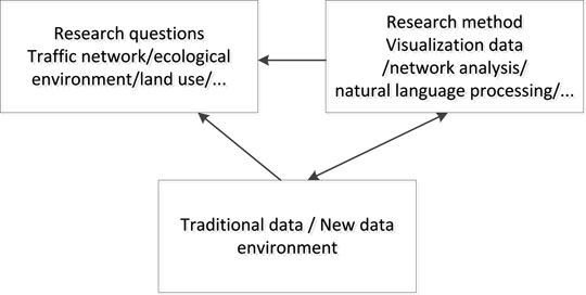
FIGURE 1. Overall framework of quantitative urban research.
In promoting the application of big data in smart city planning construction, there are many problems that need to be solved urgently. First, there are certain barriers to data exchange in the city. Although the information platform is used to complete data storage and business processing of enterprises and institutions in the city, due to the restrictions of the interests, functions, and data standards of various units, information resources cannot be truly exchanged and shared, resulting in the accumulation of massive data on various information platforms, which cannot be effectively utilized and mined. Therefore, it is necessary to further strengthen the overall management of data, establish a unified data standard system, open up the interconnection between systems and services, and realize the sharing of resources. Second, there are few scientific and technological enterprises, there are insufficient talents for big data analysis, and the application efficiency of data is low, which leads to the insufficient role of the big data technology in the construction of the smart city. Through the training and introduction of big data analysis talents, scientific and technological innovation are focused, and the application effectiveness of the big data technology is improved. Third, there are some security problems in the data stored in the information platform and the data transmitted under the network environment. Therefore, it is necessary to encrypt sensitive and important data or establish a security system to prevent hackers and illegal elements from attacking the network or collecting platform information.
Three Stages of Big Data Application in Urban Master Planning
The application of big data in urban master planning mainly includes the following three stages.
Understanding: Understanding Urban Laws
The preliminary analysis is the basis and premise of the scheme design. Traditional planning research is mostly based on the summary and observation of experience, but now with the rapid development of science and technology, the research is not limited to books and existing classical theories. Big data promote urban planning and design from empirical judgment to quantitative analysis. The analysis of residents’ behavior data such as employment, travel, and recreation can support the understanding of urban laws and enhance the understanding of the current situation so as to provide more in-depth and accurate preliminary research support for subsequent planning. The developed applications, such as large-scale models, human trace maps, and social perception mood maps, are empirical understanding of the urban law. In the future, with more open-source data, planners and decision makers will be able to more easily obtain first-hand information about the city, and it will no longer be difficult to understand the law of the city.
Creation: Planning and Programming
The formulation of the land use planning scheme is one of the core contents of urban master planning. In the process of traditional urban planning, the formulation of the land use planning scheme often depends on the experience and understanding of planners: the comprehensive ability, requirements, and preferences of planners have a direct impact on the quality of the scheme. With the application of big data in the field of urban planning, planning and design technologies and means based on quantitative analysis have also emerged, that is, “data augmented design” (Dad: data augmented design), a new form of planning and design support. Driven by quantitative urban analysis, data enhancement design provides support tools such as investigation, analysis, scheme design, evaluation, and tracking for the whole process of planning and design through data analysis, modeling, and prediction so as to improve the scientificity of design with data demonstration and to stimulate the creativity of planning designers.
Based on the problems found in the previous quantitative analysis, some schemes to solve the problems can be put forward by using design techniques, and the urban model can be used for scenario simulation. According to the scenario simulation results, the most appropriate scheme can be selected for deepening.
For sites with scarce data, the method of extracting the “urban growth gene” can be used to quantify the case reference method. This model regards the city as a living body, explores the gene of urban development, and summarizes the general laws so as to support the planning and design of the new area.
Evaluation: Evaluation of Planning Implementation
Planning implementation evaluation is an important application field of big data in urban planning. It mainly includes dynamic tracking of the planning implementation process and evaluation of the planning implementation effect.
At present, urban master planning is the ultimate blueprint for static planning, rather than the planning for the process, so it is impossible to consider the dynamics of urban development. Based on big data, the basic data used by each index can be dynamically updated so as to track and monitor the implementation process of the plan.
Using big data to evaluate planning, this study mainly introduces the application of two dimensions: one is the research on urban growth boundary and planning consistency (i.e., the consistency between planning processes); the other is the evaluation of the urban spatial structure.
Application of Big Data Technology in Smart City Construction
With the continuous improvement in management refinement, service level, the urban platform functions of complexity and diversity in the process of smart city construction, the integration of big data technology has become the key with the advent of the 5 g era, and the construction of 5 g base station network, big data technology will be more deeply integrated into multiple application levels of smart city to comprehensively improve the intelligence of the city. The relationship among big data, Internet of Things, and smart city construction is shown in Figure 2.
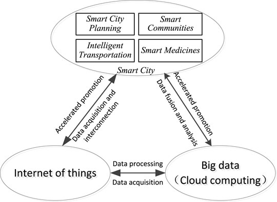
FIGURE 2. Relationship between big data, smart city, and internet of things.
Smart City Planning
In smart city planning, the integration of big data technology can improve the efficiency of urban construction, further standardize the planning of urban space, and help adjust the rational allocation of urban resources. The smart city construction mainly includes smart infrastructure, smart operation, smart service, and smart industry. It is necessary to plan urban space and build urban infrastructure with the help of massive data information, and big data can be used as the source of massive data. In the meantime, with the help of the big data technology, it helps conduct urban surveying and mapping more accurately, make effective use of land resources, make urban planning more scientific, clarify the theme and objectives of urban development, and build an intelligent collaborative system and spatial planning system. Establishing a big data analysis platform, accelerating the collection, integration, and analysis of various urban information resources, and providing timely feedback on the analysis results helps in strengthening the rationality and scientificity of urban planning.
Intelligent Transportation
To realize a smart city, we must first build an integrated and intelligent new infrastructure and promote the construction of intelligent transportation and intelligent pipe network. We should use Internet of Things, big data, and other technologies to establish an intelligent information acquisition and control system, form a big data platform for traffic management and transportation management, and monitor and collect urban traffic data in real time, such as driving speed, traffic flow in different periods, road congestion, monitoring video, traffic intersection signal lights, and other information. Through the analysis of the aforementioned information, we can find valuable laws, obtain accurate traffic information, clarify the current operation status of vehicles and roads, and present this information on the terminal in a more intuitive way through the information exchange between the big data platform and the driver terminal by using the visualization technology so as to effectively help the driver drive, plan a reasonable driving route, and scheme for it to effectively avoid traffic congestion. In the meantime, the use of the big data technology can effectively help the traffic management department make reasonable planning for intelligent transportation construction. In daily supervision, the existing traffic faults are analyzed by detecting the traffic conditions and problems of each road so as to assist in the decision-making of traffic management. Big data technology was applied to road network transportation equipment to realize real intelligence in terms of hardware and software.
Smart Communities
By building a smart community, the city’s services will be more convenient so as to improve the happiness index and satisfaction of community residents and benefit the citizens from the achievements of smart city construction. The specific implementation contents mainly include the following: continuously monitoring the community street environment, real-time detection of community garbage cans, detection of driving routes, and tracking of sanitation vehicles. By setting up integral rewards, community residents are encouraged to classify garbage and put it into corresponding dustbins. In the process of garbage delivery, residents can conduct face recognition through the camera on the dustbin. After identification, the dustbin door will open automatically. After garbage delivery, the dustbin door will close automatically. For recyclable waste such as plastic, paper, and metal, points shall be calculated according to the amount of waste. The community residents can query the number of points and exchange goods for points through mobile terminals. At the same time, the location information, temperature information, damage alarm information, and garbage filling information of the garbage can will be uploaded to the smart community platform regularly to help community personnel monitor the health situation of the community in real time and carry out efficient management.
Smart Medicines
Smart medicine refers to the integration of internet, artificial intelligence, big data, and other technologies with the traditional medical system to realize the intellectualization of the traditional medical system. Intelligent one-stop medical service, B-ultrasound intelligent diagnosis system, and patient medical archives intelligent management system all belong to the category of intelligent medical treatment. Among them, the intelligent one-stop medical service uses networked medical facilities and big data technology to provide convenient and one-stop diagnostic services for patients, remotely obtain the health data of patients, compare, and analyze these data with the data in the medical database, determine the classification of patients, and then put forward diagnostic suggestions and treatment plans for patients. The B-ultrasound intelligent diagnosis system stores massive diagnostic data such as medical staff and researchers into the system in advance. After obtaining the B-ultrasound diagnosis information of patients, it uses data mining, deep learning, and other technologies for analysis to help the medical staff determine the diagnosis results more accurately and conveniently. In the context of big data, further improvement should be made in the patient's medical file information management, a smart medical file management system should be formed, stored, and processed, the patient’s health data throughout the life cycle should be analyzed, the potential health risks of patients should be found and given early warning in time, the smart management system should be helped to retrieve the patient’s medical file information in an orderly and efficient manner, and medical disputes caused by multiple visits, loss, and confusion of inpatient medical record information should be prevented.
Wisdom Education
Smart education is a new education model and form of Internet of Things and intelligence formed by relying on information technologies such as big data, cloud computing, internet of things, and mobile communication. Smart education is an important part of smart city construction. The establishment of a smart education platform and the use of the big data analysis technology can realize the personalization of education and provide targeted and customized learning suggestions, programs, and relevant learning resources for learning objects. It should be performed by collecting the data on the school environment, teachers, and students’ learning stages, including students’ basic information, learning behavior in different periods, and learning achievement. On this basis, the collected data are preprocessed such as data classification and integration so as to provide high-quality data for data mining and data analysis. Then, the corresponding data analysis model is established, the learning objects are classified, the learning preferences and characteristics of these kinds of students are identified, the potential laws in learning behavior are excavated, and suggestions are provided for the adjustment of learning plans for these kinds of students. In addition, the data visualization technology can also be used to analyze students’ learning preferences, mastery of learning contents, and academic achievements.
Conclusion
The application of the big data technology in the construction of a smart city will help improve the intelligence level of the city. A comparison between the new urban spatial data environment and the traditional data environment is shown in Table 2. In addition to the aspects mentioned in the article, the construction of a smart city also involves smart public services, smart logistics, smart finance, etc., giving full play to the role of big data, artificial intelligence, and other technologies and constantly analyzing and mining the valuable information hidden in the data to help build smart cities.

TABLE 2. Comparison between the new urban spatial data environment and traditional data environment.
Data Availability Statement
The original contributions presented in the study are included in the article/Supplementary Material; further inquiries can be directed to the corresponding author.
Author Contributions
YZ wrote the article, SL performed the experimental analysis, HC was responsible for data collection and analysis, and YX was responsible for article revision.
Funding
This research was supported by the Research on Application of Big Data in Jingmen Urban Planning and the Science and Technology Planning Project of Jingmen Science and Technology Bureau (Grant No. 2021YDKY168) The Outstanding Youth Science and Technology Innovation Team Project of Colleges and Universities in Hubei Province (Grant No. T201923).
Conflict of Interest
The authors declare that the research was conducted in the absence of any commercial or financial relationships that could be construed as a potential conflict of interest.
Publisher’s Note
All claims expressed in this article are solely those of the authors and do not necessarily represent those of their affiliated organizations, or those of the publisher, the editors, and the reviewers. Any product that may be evaluated in this article, or claim that may be made by its manufacturer, is not guaranteed or endorsed by the publisher.
References
Ahmad, O. (2021). Cyber-Physical Systems and Smart Cities in India: Opportunities, Issues, and Challenges [J]. Telecommun. Syst. Manag. 10 (12), 7714. doi:10.3390/s21227714
Chai, N., Mao, C., Ren, M., Zhang, W., Poovendran, P., and Balamurugan, P. (2021). Role of BIC (Big Data, IoT, and Cloud) for Smart Cities [J]. Arab. J. Sci. Eng. doi:10.1007/s13369-021-05888-x
Dowling, R., Pauline, M. G., Sophia, M., and Jathan, S. (2021). How Smart Cities Are Made: A Priori, Ad Hoc and Post Hoc Drivers of Smart City Implementation in Sydney, Australia [J]. Urban Stud. 58 (16), 3299–3315. doi:10.1177/0042098020986292
Gao, D., Wu, J., and Niu, L. (2021). “A Method for Comprehensive Ability Assessment of Smart City Construction from the Perspective of Big Data[C],” in 2021 International Conference on Tourism, Economy and Environmental Sustainability, Xi'an, China, Wuhan, 27-28 March 2021, 71–74. (ICITBS 2021) PartⅠ. doi:10.1051/e3sconf/202125101053
Jasmina, P. (2021). Adoption of Big Data Technologies in Smart Cities of the European Union: Analysis of the Importance and Performance of Technological Factors. Croat. Regional Dev. J. 2 (1), 11–29. doi:10.2478/crdj-2021-0005
Lavalle, A., Teruel, M. A., Maté, A., and T, J. (2020). Improving Sustainability of Smart Cities through Visualization Techniques for Big Data from IoT Devices [J]. Sustainability 12 (14). doi:10.3390/su12145595
Li, Z., and Han, P. (2020). Current Situation and Problems of Smart City Development in China Based on Big Data Analysis [J]. IOP Conf. Ser. Mater. Sci. Eng. 750 (1), 012116. doi:10.1088/1757-899X/750/1/012116
Liu, F., and Gao, J. (2021). “The Application of Big Data Technology in Smart City [J],” in E3S Web of Conferences, 251.
Minaei, N. (2021). Smart Cities:Critical Debates on Big Data, Urban Development and Social Environmental Sustainability[M]. Boca Raton: CRC Press. 2021-10-10.
Popescu, G. H., George, L., Kovacova, M., Valaskova, K., and Jana, M. (2020). Urban Sustainability Analytics: Harnessing Big Data for Smart City Planning and Design[J]. Theor. Empir. Res. Urban Manag. 15 (2), 39–48.
Prakash, K. B., Nayak, J., Madhhav, B. t., Padmanaban, S., and Balas, V. E. (2021). Big Data Analytics and Intelligent Techniques for Smart Cities [M]. Boca Raton: CRC Press. 2021-04-07.
Qian, C., and Li, X. (2020). Construction of Smart City Evaluation System Based on Big Data [J]. IOP Conf. Ser. Mater. Sci. Eng. 740, 012164. doi:10.1088/1757-899X/740/1/012164
Sun, K., and Tang, Y. (2021). Research on the Architecture and Application of Smart City Based on Big Data [J]. J. Phys. Conf. Ser. 2044 (1), 012195. doi:10.1088/1742-6596/2044/1/012195
Tania, C., Sara, M., and Silvia, C. (2021). Big Data Analytics for Smart Cities. Electronics 10 (12), 1439.
Xiang, Ning. (2020). Research on the Application of Big Data and Internet of Things Technology in Smart City [J]. Int. J. Comput. Eng. 5 (2).
Yaghoob, K., Mostafa, H. K., Mohammad, A., and Ebrahim, M. (2021). Leveraging Big Data in Smart Cities: A Systematic Review [J]. Concurrency Comput. Pract. Exp. 33 (21).
Yanli, G. (2021). Research on the Application of Big Data Technology in Smart City Construction [J]. Inf. Rec. Mater. 22 (05), 74–75.
Ying, L., and lunlun, L. (2017). Four Changes in Quantitative Urban Research under the New Data Environment [J]. Int. urban Plan. 32 (01), 64–73. doi:10.22217/upi.2015.299
Ying, L., and Qizhi, M. Theory and Method of Big Data in Urban Planning [M]. China Construction Industry Press.
Ying-Hua, L. U. (2019). The application of big data in smart city planning. Intell. Build. Smart City 7 (13), 114–115.
Zhang, D., Pee, L. G., Pan Shan, L., and Cui, L. (2022). Big Data Analytics, Resource Orchestration, and Digital Sustainability: A Case Study of Smart City Development [J]. Gov. Inf. Q. 39 (1), 101626. doi:10.1016/j.giq.2021.101626
Zhao, Y., and Li, S. (2021). Network Public Opinion Monitoring Based on MapReduce [J]. J. Phys. Conf. Ser. 2037 (1), 012031. 2021 2nd International Conference on Artificial Intelligence and Information. doi:10.1088/1742-6596/2037/1/012031
Keywords: big data, new data environment, smart city, city planning, city building
Citation: Zhao Y, Li S, Chen H and Xu Y (2022) Application of Smart City Construction in a New Data Environment. Front. Energy Res. 10:908338. doi: 10.3389/fenrg.2022.908338
Received: 30 March 2022; Accepted: 21 April 2022;
Published: 27 May 2022.
Edited by:
Fadi Al-Turjman, Near East University, CyprusReviewed by:
Zhiyong Jiang, Guilin University of Aerospace Technology, ChinaPing Wang, Jiangxi University of Technology, China
Jiansong Fang, Guangdong Baiyun University, China
Copyright © 2022 Zhao, Li, Chen and Xu. This is an open-access article distributed under the terms of the Creative Commons Attribution License (CC BY). The use, distribution or reproduction in other forums is permitted, provided the original author(s) and the copyright owner(s) are credited and that the original publication in this journal is cited, in accordance with accepted academic practice. No use, distribution or reproduction is permitted which does not comply with these terms.
*Correspondence: Yunhong Zhao, enlob25nQGpjdXQuZWR1LmNu