- 1U.S. Geological Survey, Western Ecological Research Center, Arcata, CA, United States
- 2U.S. Geological Survey, Western Ecological Research Center, Davis, CA, United States
- 3National Park Service, Klamath Network Fire Ecology Program, Orick, CA, United States
- 4National Park Service, Klamath Inventory and Monitoring Network, Ashland, OR, United States
A Corrigendum on
Spatially explicit models of seed availability improve predictions of conifer regeneration following the 2018 Carr Fire in northern California
By Wright M, van Mantgem P, Buffington K, Thorne K, Engber E and Smith S (2023) Front. Ecol. Evol. 11:1229123. doi: 10.3389/fevo.2023.1229123
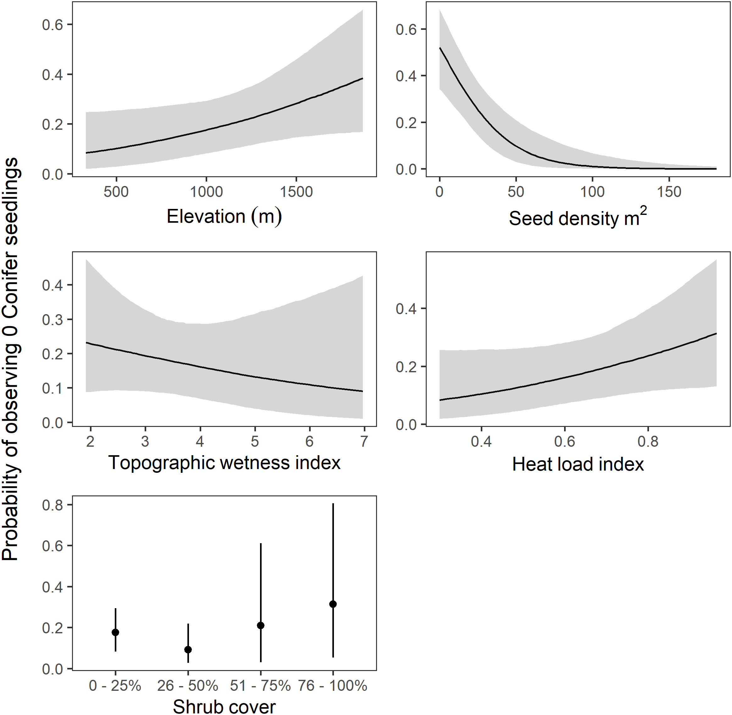
In the published article, there was an error in Figure 7 and Figure 8 as published. Incorrect units were used on the x axis of the seed availability plots: they should read “Seed density m2”, not “Seed density m2 ha−1”. The corrected Figures 7 and 8 and their captions appear below. The authors apologize for this error and state that this does not change the scientific conclusions of the article in any way. The original article has been updated.

Figure 7 Model predictions of probability of observing zero conifer seedlings (± 95% credible intervals) for each predictor in the model with the highest eld. Predictions are made holding all other variables constant. Note the different axes scales.

Figure 8 Model predictions of conifer seedling density in stems per hectare (± 95% credible intervals) for each predictor in the model with the highest eld. Predictions are made holding all other variables constant. Note the different axes scales.
Publisher’s note
All claims expressed in this article are solely those of the authors and do not necessarily represent those of their affiliated organizations, or those of the publisher, the editors and the reviewers. Any product that may be evaluated in this article, or claim that may be made by its manufacturer, is not guaranteed or endorsed by the publisher.
Keywords: wildland fire, conifer regeneration, dispersal kernel, Bayesian modeling, lidar
Citation: Wright M, van Mantgem P, Buffington K, Thorne K, Engber E and Smith S (2023) Corrigendum: Spatially explicit models of seed availability improve predictions of conifer regeneration following the 2018 Carr Fire in northern California. Front. Ecol. Evol. 11:1337949. doi: 10.3389/fevo.2023.1337949
Received: 13 November 2023; Accepted: 14 November 2023;
Published: 06 December 2023.
Approved by:
Frontiers Editorial Office, Frontiers Media SA, SwitzerlandCopyright © 2023 Wright, van Mantgem, Buffington, Thorne, Engber and Smith. This is an open-access article distributed under the terms of the Creative Commons Attribution License (CC BY). The use, distribution or reproduction in other forums is permitted, provided the original author(s) and the copyright owner(s) are credited and that the original publication in this journal is cited, in accordance with accepted academic practice. No use, distribution or reproduction is permitted which does not comply with these terms.
*Correspondence: Micah Wright, bWN3cmlnaHRAdXNncy5nb3Y=
 Micah Wright
 Phillip van Mantgem
 Kevin Buffington
 Karen Thorne
 Eamon Engber3