 Jun Ma
 Vadim Khromykh2
 Jinliang Wang
94% of researchers rate our articles as excellent or good
Learn more about the work of our research integrity team to safeguard the quality of each article we publish.
Find out more
ORIGINAL RESEARCH article
Front. Ecol. Evol., 15 December 2023
Sec. Environmental Informatics and Remote Sensing
Volume 11 - 2023 | https://doi.org/10.3389/fevo.2023.1276239
This article is part of the Research TopicRemote Sensing for Environmental MonitoringView all 13 articles
The study of the spatiotemporal evolution of landscape ecological hazard and human and natural influences is essential for conservative management and regional sustainable development. This study applied a landscape pattern analysis method and geodetector to multi-source data for 2000, 2010, and 2020 to analyze changes in and drivers of landscape ecological hazard in Laos. The results indicated that: (1) There were more prominent changes in landscape types in Laos. Forest area decreased, whereas the areas of other landscape types increased. There was an overall steady change in the landscape patterns of Laos. Besides for significant changes in the artificial surface landscape index, landscape indices remained stable; (2) The cumulative high and extreme ecological hazard areas increased by 1,947.81 km2, whereas the cumulative areas of low and minimal ecological hazard decreased by 8,461.8 km2. Areas of low and moderate ecological hazard accounted for > 85% of the total area. Areas of low ecological hazard were mainly in the northwest and southeast. The area of high ecological hazard was concentrated in the central and northeastern regions. The distributions of different landscape ecological hazards in Laos during the study period were similar, with general patterns of decreasing hazard from north to south; (3) A positive Moran’s I of landscape ecological hazard in Laos was obtained. While the agglomeration effect was pronounced, it decreased over time, resulting in a weakening in spatial autocorrelation. A significant positive autocorrelation was observed in the spatial distribution of landscape ecological hazard in the study area. Agglomerated areas of high and low ecological hazard were mainly concentrated in the northeast and southeast, respectively; (4) The spatiotemporal evolution of landscape ecological hazard in Laos over the last 20 years could be attributed to interactions between natural and anthropogenic influences. Natural influences were a significant driver of changes to landscape ecological hazard in Laos, with annual precipitation and average temperature being the most significant. Anthropogenic influences, including socioeconomic factors and regional accessibility, significantly impacted local ecological deterioration in Laos.
Human socioeconomic development is dependent on ecosystem services. Therefore, maintaining the integrity of natural ecosystems is essential for human survival (Munns et al., 2016). However, continuous human expansion has resulted in the degradation of natural ecosystems globally (Liu et al., 2022). Ecological hazard is as risks of external factors exerting stress on an ecosystem. These stresses can degrade the productivity, health, genetic structure, and aesthetic and economic value of ecosystems (Chen et al., 2013). Since many factors can interact to cause ecological hazard, the scope of ecological hazard can be considerable and complicated to predict (Suter, 2001). Landscape ecological hazard assessment can be used to characterize the regional-scale risks of adverse effects on ecosystems by environmental pollution, anthropogenic endeavors, or natural disasters. The importance of landscape ecological hazard assessment has gradually increased since this risk assessment method overcomes the limitation of traditional regional risk assessment by using a specific natural risk factor (Paustenbach, 2015). The ecological hazard assessment based on landscape pattern emphasizes the influence of landscape structure, spatiotemporal heterogeneity, and scale effect on ecological hazard, thereby achieving a comprehensive characterization and spatial visualization of multiple risks (Chen et al., 2013). Therefore, the study of landscape ecological hazard can act as the foundation for regional hazard prevention and can assist in the management and optimization of regional patterns in the landscape.
Studies incorporating landscape ecological hazard assessment have increased both in China and abroad. There have been many recent studies on ecological hazard in different regions, mainly focusing on watersheds (Kapustka et al., 2001), oases (Hope, 2006), coastal zones (Yanes et al., 2019), wetlands (Malekmohammadi and Rahimi Blouchi, 2014), and cities (Ran et al., 2022). These studies have widely applied the landscape pattern index (Su et al., 2012; Zhang et al., 2022), entropy (Liu et al., 2013; Gao et al., 2022), and exposure-response (Chapman et al., 1998; Bartell, 2006) methods for the construction of an ecological hazard evaluation model, which has been combined with geographical information system (GIS) spatial modeling. The scales at which these studies have been conducted have evolved from single to multiple. Some studies have assessed landscape ecological hazard and appropriate methods by determining appropriate spatial granularity (Hope, 2006). The above studies have focused on landscape ecological hazard assessment by constructing an appropriate model and spatial analysis. There remains a need for further studies on ecological risk assessment at a national scale, as well as studies on local and regional influencing factors. There also remains a need for further analyses of the cumulative effects of the overall evolution of risk on local systems (Hope, 2006).
Loas is the only landlocked country in the Mekong River Basin, and has had to confront significant challenges in recent years, including the combined effects of natural development-oriented economic growth, a growing population, and the resulting environmental pollution, land degradation, and depletion of natural resources. The study of landscape ecological hazard pattern is significant for enabling regional environmental conservation and national ecological security in that country. Concurrently, this such study can improve landscape ecology theory and augment landscape planning and management decision-making. The aim of the present study was to apply principles of landscape ecology and spatial statistical analysis to land cover data for 2000, 2010, and 2020, to construct a landscape ecological hazard index and ecological hazard assessment model for quantitatively analyzing landscape ecological hazard and the associated natural and anthropogenic influencing factors in Laos.
Laos is a landlocked country forming part of the northern Indochina Peninsula (13°56’–22° 27’ N, 100°02’–107°38’E). Laos consists of 17 and one provinces and municipality, respectively, and has a total area of 236,800 km2 (Figure 1). Laos has a complex and diverse topography, consisting predominantly (80%) of mountains and plateaus. The remaining area forms the Mekong River Valley, along which there are basins and small plains. The terrain of Laos decreases from north to south. The region falls into tropical and subtropical monsoon climate zones. The region experiences a distinct rainy season with annual average precipitation and annual average temperature of 1,250 mm–3,750 mm and 20°C–30°C, respectively. Laos has a developed water system, with the Mekong River in the west representing the largest river in the region.
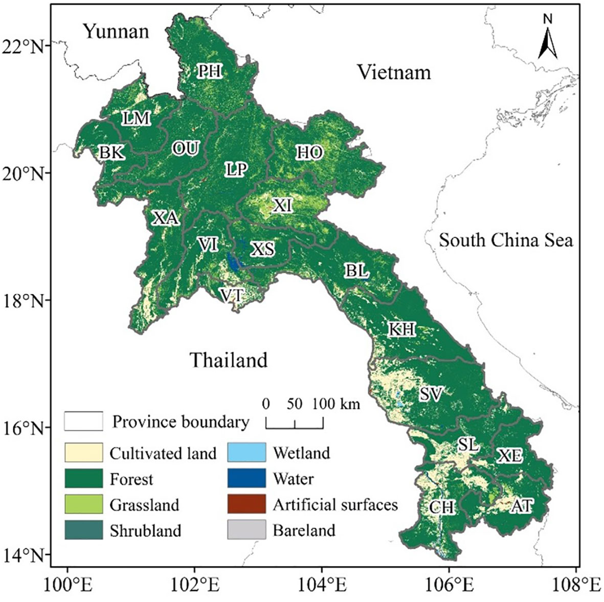
Figure 1 Geographical location and land cover of Laos. PH, Phongsali; LM, Louang Namtha; BK, Bokeo; OU, Oudomsai; LP, Louangphrabang; HO, Houaphan; XA, Xaignabouri; VI, Viangchan; XI, Xiangkhoang; XS, Xaisomboun; VT, Vientiane; BL, Bolikhamxai; KH, Khammouan; SV, Savannakhet; SL, Saravan; XE, Xekong; CH, Champasak; AT, Attapu.
The present study used data falling into three broad categories: (1) natural environment data, (2) socioeconomic data, and (3) regional accessibility data. The present study utilized land cover data for the region to extract the landscape pattern index. The spatial resolution of these data for 2000, 2010, and 2020 was 30 m × 30 m. The present study considered eight land use types: (1) artificial, (2) bare land, (3) cultivated land, (4) forest, (5) grassland, (6) shrubland, (7) water, (8) wetlands. Temperature and precipitation data utilized in the current study were downloaded from the Google Earth Engine (GEE) platform, and these data were processed to obtain annual averages. Data for the Normalized Difference Vegetation Index (NDVI) were obtained through the GEE platform and were utilized to estimate fractional vegetation cover (Pettorelli et al., 2005). Table 1 shows the specific data sources used in the present study.
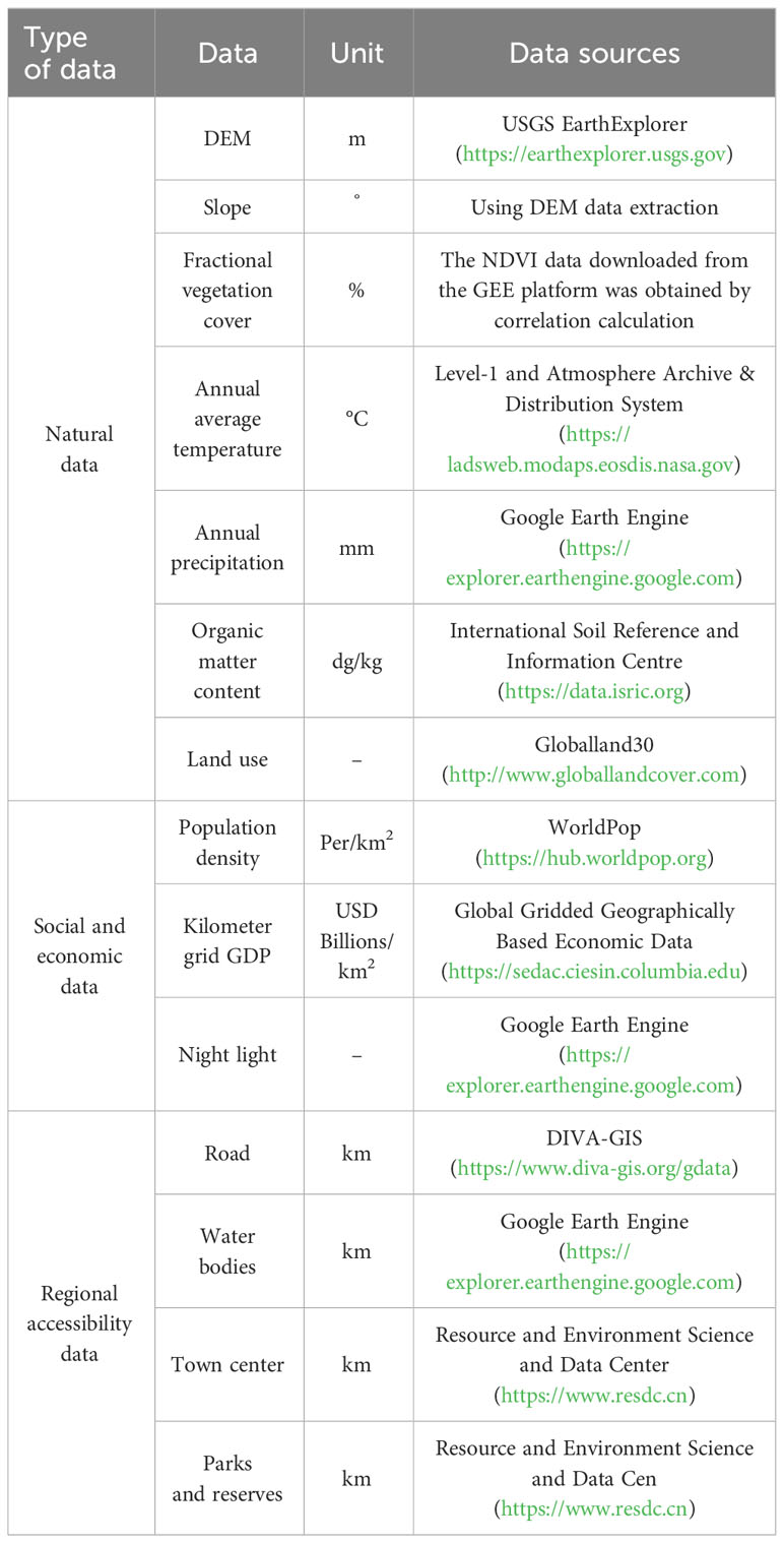
Table 1 Types of data used in the present study and their sources.
As an essential basis for the study of landscape ecological hazard, the choice of spatial granularity will directly affect the spatial representation accuracy of landscape ecological hazard. Therefore, selecting the spatial granularity and conducting relevant scientific research is necessary when researching landscape ecology. The present study gridded the study area in ArcGIS 10.2.2 software, considering the optimal grid size for calculating the landscape ecological hazard index, the size of the study area, and the convenience of hazard index data extraction. The equal spacing sampling method was used. Typically, the division of evaluation units exceeds the average landscape patch area by 2 to 5 (Chen et al., 2013). The present study evaluated grid sizes of granularities of 10 × 10 km, 15 × 15 km, and 20 × 20 km. However, the 15 × 15 km grid was optimal and was chosen to divide Laos into 1,364 evaluation units (Figure 2) (Zhang et al., 2020).

Figure 2 Division of Laos into 15 × 15 km grids for calculation of the ecological hazard area.
The landscape pattern index provides dense information on landscape layout, and can utilize a single or a combination of several indices to analyze the spatial structure and evolution of the landscape. The present study selected six landscape indices to comprehensively reflect the patterns of landscape and characteristics of the study area and to reduce information redundancy. These were the landscape fragmentation, isolation, dominance, disturbance, vulnerability, and loss indices (Table 2). The moving window method using a 15-km window was applied in Fragstats 4.2 to calculate the landscape pattern index of Laos (Bai and Weng, 2023; Xu et al., 2023). The window was moved from the left, upper section of the study area, and progressed at a single-grid step. The window calculated the landscape pattern index for each grid and assigned the center grid as the landscape index of the center point of each sample plot. The current study obtained the index of landscape disturbance by superimposing the landscape, landscape isolation, landscape dominance, and landscape vulnerability indices using an expert scoring method.

Table 2 Methods used to calculate the landscape pattern indices.
An ecological hazard index is an index characterizing disturbance of the landscape structure and can be used to reflect the degree of human influence on natural ecosystems. Ecological hazard indices quantitatively describe the effects of natural and anthropogenic influences on ecosystems (Bayliss et al., 2012). The present study reduced information redundancy among individual indicators by using the relative areas of landscape components, the landscape vulnerability index, and the landscape interference index. Fragstats 4.2 software was used to construct the landscape ecological hazard evaluation model using the moving window method and index calculation, which was taken to represent the ecological hazard of the center point of each plot (Li et al., 2017). The index was calculated as follows (Equation 1):
where ERIi is the index of landscape ecological hazard in the ith sample unit; Aki is the areal extent of landscape type i in the kth sample unit; Ak is the areal extent of the kth sample unit; Ri is the index of landscape loss.
Analysis of spatial data is used to find the rules under which spatial data is distributed and its spatial heterogeneity (Anselin, 1996). The present study applied exploratory spatial data analysis to analyze the ecological hazard of Laos and to identify associated patterns. The present study used global and local spatial autocorrelation to characterize the ecological hazard of Laos. The geodetector was used to identify factors driving the spatial and temporal variation in ecological hazard in Laos.
The ecological hazard index has random and structural spatial variation. The present study analyzed the spatial heterogeneity of the index of landscape ecological hazard. This was achieved by fitting the ecological hazard index to a semi-variogram in ArcGIS to obtain the best-fitting model (Hengl, 2009). The present study then applied Kriging interpolation to interpolate the three datasets (Oliver and Webster, 1990), following which spatial distributions of the hazard to the landscape ecology were generated. The present study applied the transfer matrix model to analyze landscape ecological hazard over different periods. The grading standards used in the present study to evaluate results were consistent with those used in previous studies (Li et al., 2020; Gong et al., 2021; Zhang et al., 2022). Landscape ecological hazard in 2020 was separated into five grades using the natural discontinuity point method: (1) minimal ecological hazard (ERI< 0.0709); (2) low ecological hazard (0.0709 ≤ ERI< 0.1157); (3) moderate ecological hazard (0.1157 ≤ ERI< 0.1773); (4) high ecological hazard (0.1773< ERI ≤ 0.2782); (5) extreme ecological hazard (ERI ≥ 0.2782). Data for the remaining two periods were categorized in the same way that for the 2020s.
Autocorrelation in the spatial dimension can be used to identify spatial interdependence between two or more variables (Koenig, 1999). The present study applied spatial autocorrelation to analyze the distributions of variables and correlations between variables (Anselin, 2003). Identification of spatial correlation between hazard attributes of adjacent areas was conducted by applying spatial autocorrelation. GeoDa and ArcGIS software were used to apply the global spatial autocorrelation index Moran’s I and the local spatial autocorrelation index LISA to evaluate spatial differences in ecological hazard. Moran’s I have a value of −1 and 1 and can be used to reflect similarities in a particular attribute between adjacent units. Moran’s I > 0,< 0, and = 0 indicate a positive, negative, and no correlation, respectively, and aggregated, dispersed, and random research units, respectively (Diniz-Filho et al., 2003). Moran’s I was calculated as follows (Equation 2):
where xi and xj represent variable x at adjacent points, x represents the mean of the variables, ωij indicates the adjacent weight, and n represents total hazard points.
Moran’s I can only indicate the distribution of the index of ecological hazard. Therefore, the current study integrated the LISA index to allow further exploration of the aggregation of the local hazard index and to identify abnormal spatial characteristics. The LISA index can be divided into four types: (1) High-High; (2) High-Low; (3) Low-High; (4) Low-Low. The LISA index was used to represent different spatial clustering distributions and was calculated as follows (Equation 3):
where n’ represents the size of the sample and S2 represents statistical variance.
A geodetector is a statistical method used to identify drivers of geographic spatial characteristics by identifying heterogeneity in spatial stratification of events. Heterogeneity in the spatial stratification represents variance in a region that exceeds the within-layer sum of the variance. The geodetector used in the present study incorporated risk factor, ecological, and interaction detectors (Zhu et al., 2020). The present study selected the factor detector for use in the geodetector through reference to relevant previous research results (Huang et al., 2020; Liang et al., 2022; Li et al., 2022; Xu et al., 2023). The present study identified 14 socioeconomic and regional accessibility factors affecting the landscape ecological hazard in Laos, including the digital elevation model (DEM), slope, fractional vegetation cover, annual average temperature, annual precipitation, organic matter content, population density, kilometer grid GDP, night light, distance from the road, distance to water, distance from the town center, and distance to parks and reserves.
The present study calculated the landscape pattern index of each landscape type in the study area in 2000, 2010, and 2020 using the statistical analysis function in Fragstats 4.2 and Excel 2010 (Table 3). Interactions between natural and anthropogenic influences result in changes in the area and number of patches of each landscape, resulting in changes to the hazard index. As shown in Table 3, forest, cultivated land, and grassland represented the main landscape types in Laos. There was a decreasing trend in forest area over the last two decades, whereas there were increasing trends in cultivated land and grassland. The area of water bodies first increased from 2000 to 2010 and then decreased from 2010 to 2020. While artificial surfaces had the smallest area, there was a significant increase in artificial surfaces in Laos between 2010 and 2020, with that in 2020 exceeding that in 2000 and 2010 by factors of 6.18 and 4.65, respectively. The number of grassland patches significantly exceeded those of other land covers, resulting in this land cover obtaining the most extensive fragmentation index. The large fragmentation index of grassland resulted in a small random scattered distribution. Forest showed the second-largest number of patches and random distribution, with decreasing patch numbers over time.
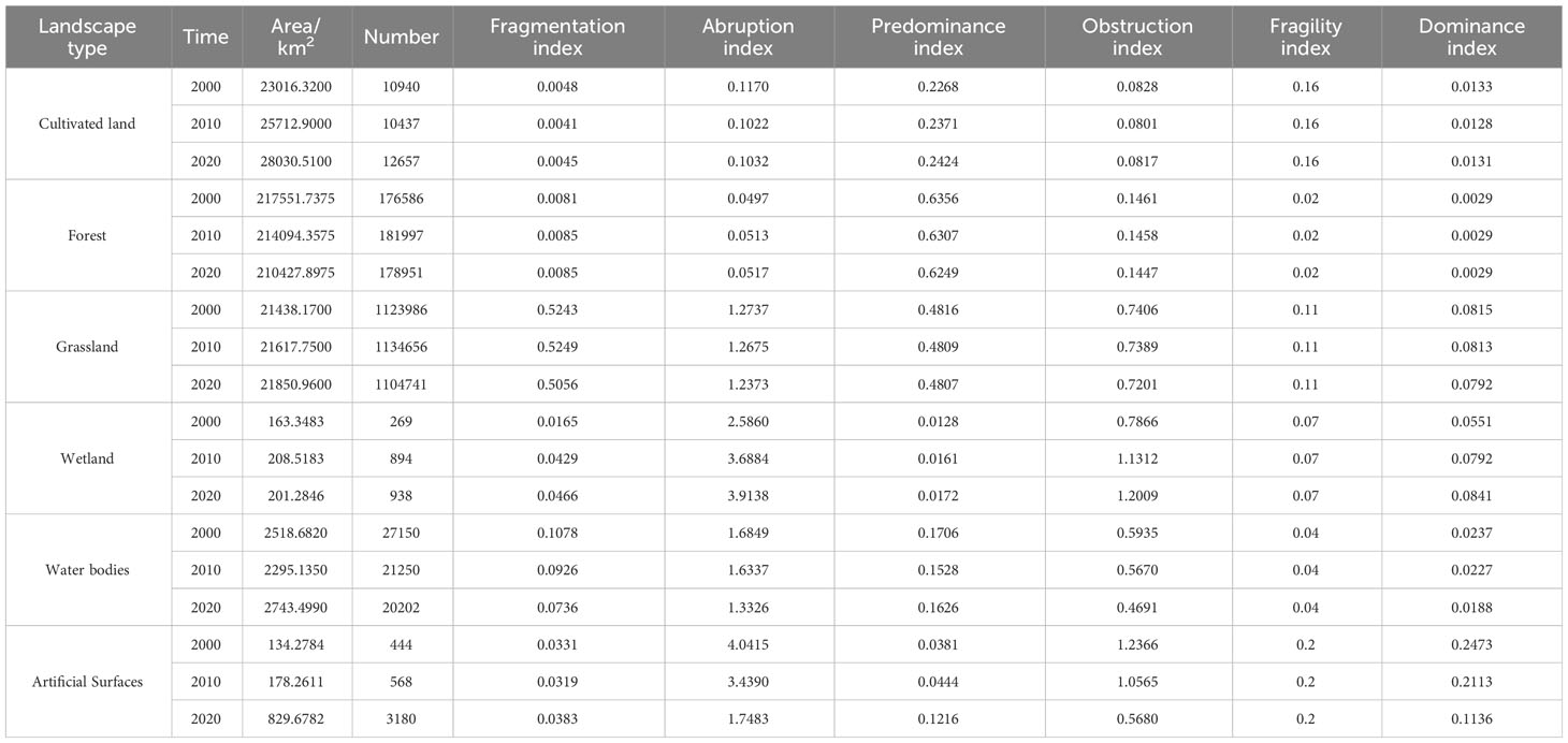
Table 3 Indices of patterns of landscape in Laos from 2000 to 2020.
Many factors affect landscape ecological hazard, including the vulnerability, disturbance, type, and land use structure of landscapes. Ecological hazard can be characterized by landscape loss. Artificial surfaces showed the most significant loss index, followed by grassland, wetland, water bodies, and cultivated land, while forest had the lowest loss index. Despite the high loss index of artificial surfaces, this land cover had minimal influence on landscape ecological hazard due to its limited landscape area. The most extensive landscape loss index of artificial surfaces could be attributed to its highest vulnerability among the assessed landcover types. The landscape loss index also varied among the different periods. There were continual decreases in landscape loss of artificial surfaces and water bodies. The change in artificial landscape surfaces is most significant, changing from 0.2473 in 2000 to 0.1136 in 2020, representing an increase factor of 2.18 over 20 years. While this decreasing trend reduced the influence of artificial surfaces on landscape ecological hazard, its influence remained significant. The landscape loss indices of other landscape types generally remained unchanged.
Laos showed low, moderate, and high ecological hazard from 2000 to 2020, with the cumulative areas of these three categories accounting for 79.19%–91.06% of the total area (Figure 3). The distributions of landscape ecological hazard in Laos were similar among the three-time points. Ecological hazard in the study area decreased from north to south. Areas of high ecological hazard were mainly distributed around areas of extreme ecological hazard, whereas areas of low ecological hazard were mainly adjacent to those of minimal ecological hazard. The complex geographical environments in the northwest, central east, and south of the study area showed clear vertical zonal characteristics. Various landscape patches showed a staggered distribution, such as forest land, resulting in high separation, serious fragmentation, and low connectivity. Interactions among different landscapes were obstructed, producing elevated ecological hazard. In addition, the region implements relatively redundant agricultural production methods. Long-term unsustainable agricultural production activities have resulted in frequent transformations between landscape components (Castella et al., 2013) and an overall decline in ecological environmental quality, thereby increasing the ecological hazard of the area. Areas of higher ecological hazard were concentrated in the Xiangkhoang Plateau in northeastern Laos, HO, and XI provinces. The dominant types of landscape were forest, grassland, and cultivated land. These landcover types showed scattered and fragmented distributions, forming a clear vertical band spectrum. There were clear fragmentation characteristics of landscape patches. This fragmentation has destroyed the integrity and stability of the ecosystem, leading to high ecological hazard. Areas of high ecological hazard were concentrated in the transition from higher to moderate ecological hazard. These areas were widely distributed in the PH, LM, LP, HO, XI, XA, VI, VT, BL, SV, and CH provinces. Change in the distribution of high ecological hazard involved extending areas to surrounding areas, during which areas of minimal ecological hazard transition to high ecological hazard. This change was most obvious in the XA province in west Laos and CH and AT provinces in the south. Most high ecological hazard areas were in the mountainous and plateau areas characterized by high terrain. The distribution of areas of moderate ecological hazard and associated temporal change were similar to those of areas of high ecological hazard, with areas of moderate ecological hazard located adjacent to areas of high ecological hazard. Areas of moderate ecological hazard consisted mainly of cultivated land and artificial surfaces. The region experienced considerable disturbance from anthropogenic activities due to the expansion of cultivated land and urban areas during the middle and late stages. However, the stability of agricultural land and construction land remained strong, with these land cover types resistant to changes in the environment and anthropogenic endeavors. Areas of low ecological hazard were mainly in BK province, north of the study area, and in KH and SV provinces in central Laos. Low ecological hazard dominated SL, XE, and AT in the south, with forest and grassland being the main land cover types. The establishment of national parks and nature reserves resulted in increases in the region’s stability, thereby increasing the region’s resilience to environmental changes and anthropogenic endeavors. The natural landscape of the study area is well-preserved and is not susceptible to human interference, resulting in low landscape loss.
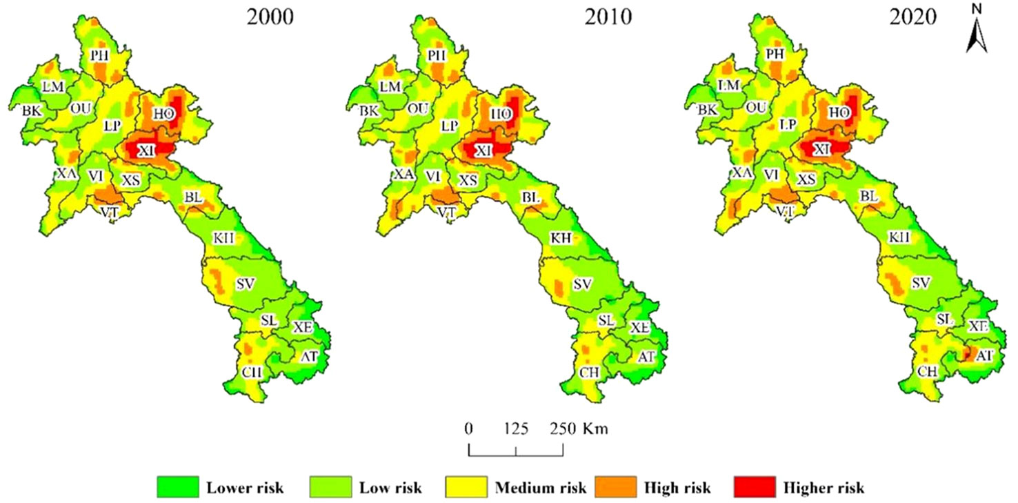
Figure 3 Spatial distribution of landscape ecological hazard falling into various categories in Laos in 2000–2020. PH, Phongsali; LM, Louang Namtha; BK, Bokeo; OU, Oudomsai; LP, Louangphrabang; HO, Houaphan; XA, Xaignabouri; VI, Viangchan; XI, Xiangkhoang; XS, Xaisomboun; VT, Vientiane; BL, Bolikhamxai; KH, Khammouan; SL, Saravan; SV, Savannakhet; XE, Xekong; CH, Champasak; AT, Attapu.
There were increases in landscape ecological hazard in Laos from 2000 to 2020. The areas of high/higher, moderate, and low/minimal ecological hazard increased by 1,947.8.1 km2, increased by 6,513.9 km2, and decreased by 8,461.8 km2, respectively (Table 4). The Sankey map of landscape ecological hazard in Laos over the 2-decade study period (Figures 4, 5) shows that the area of extreme ecological hazard increased from 2.86% to 3.02% (407.9 km2). Areas of minimal ecological hazard mainly transitioned to low and moderate ecological hazard. There was less transition in areas of high and extreme ecological hazard, with changes in ecological hazard in these areas having minimal impact on overall ecological hazard in Laos. Processes contributing to the transition of areas to moderate ecological hazard were more complex, indicating the need for increased ecological stability. There needs to be an increased focus on maintaining ecosystem stability in the region to avoid the intensification of landscape fragmentation and a transition to a higher level of ecological hazard. Future effects of human activities and climate change will inevitably increase interference in and the destruction of the natural landscape in the study area, resulting in a significantly expanded area of medium ecological hazard and a concurrent decrease in the area of lower ecological hazard. Therefore, it is expected that the ecological state of the landscape in Laos will decline in the future. Urban expansion results in fragmentation of landscape patches along the urban fringe, which in turn leads to changes in landscape structure and function.
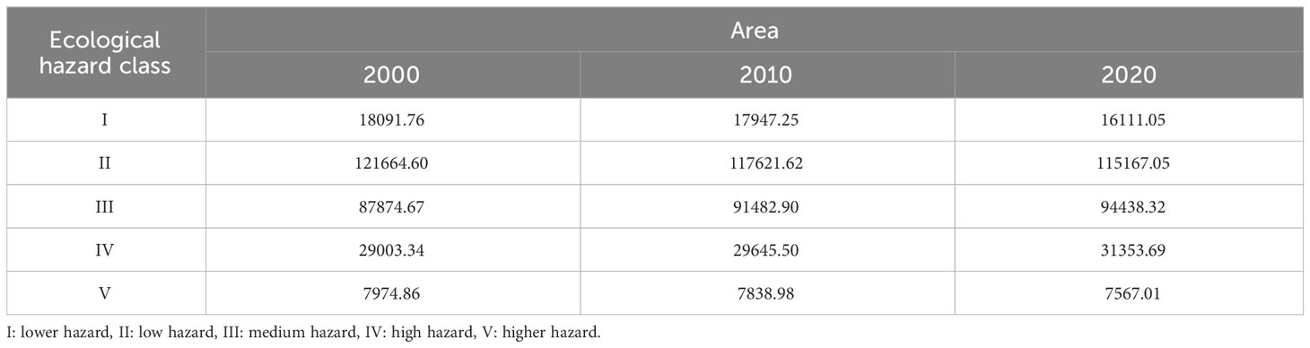
Table 4 Relative area of landscape ecological hazard categories in Laos for 2000–2020 (km²).
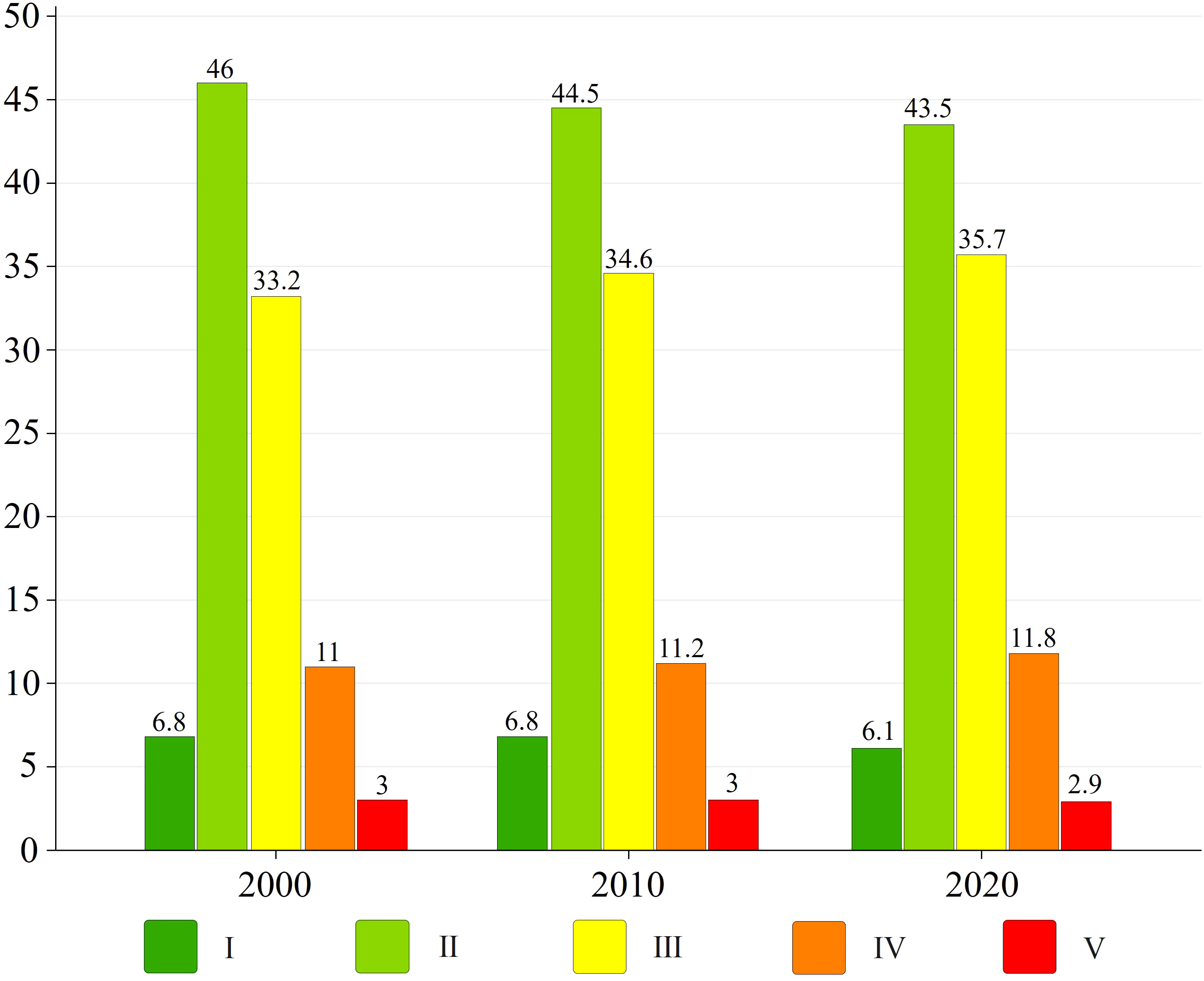
Figure 4 Proportion of landscape ecological hazard classes in Laos, 2000–2020 (%).

Figure 5 Sankey diagram showing the transfer of landscape ecological hazard in Laos between 2000–2020 (km2). I: lower hazard, II: low hazard, III: medium hazard, IV: high hazard, V: higher hazard.
As shown in Figure 6, the present study conducted global autocorrelation based on the three periods of landscape ecological hazard in the study area. The Moran’s I values of the three periods were 0.651, 0.642, and 0.623, respectively. The significant Z and P values within the confidence interval suggested significant positive correlations in the landscape ecological hazard index in the study area between the three periods. The distribution of Moran’s I index in each quadrant showed that landscape ecological hazard among the three periods were spatially clustered and affected each other. There was a decreasing trend in the global Moran’s I, indicating a weakening in spatial autocorrelation and a decrease in spatial convergence.
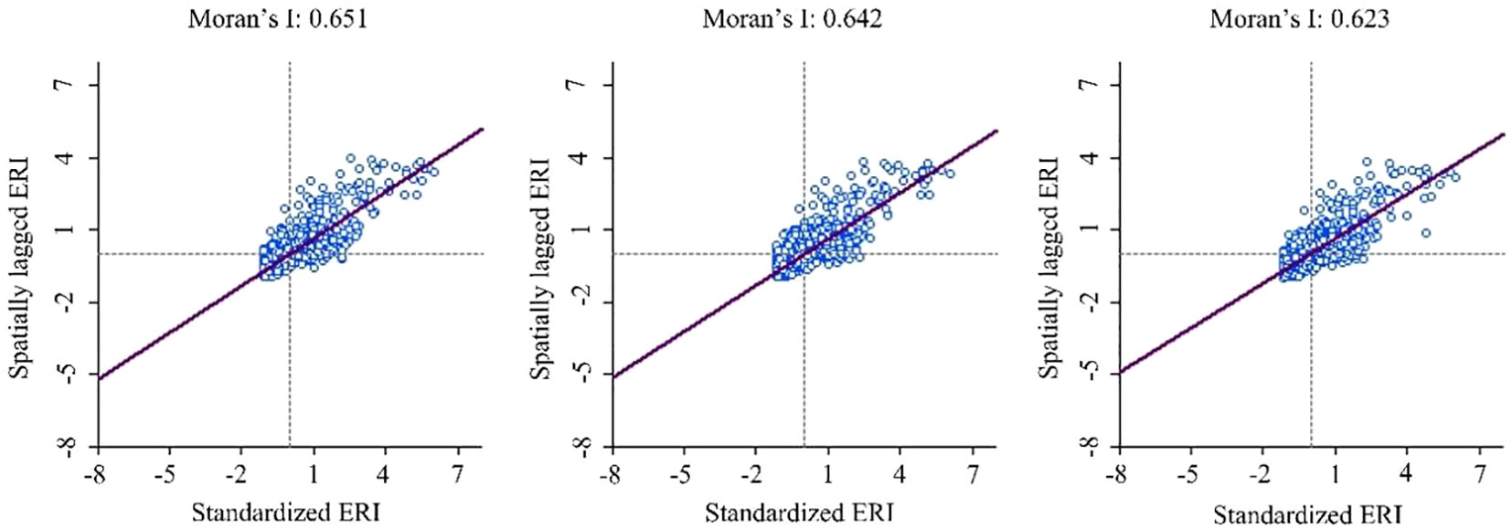
Figure 6 Scatter plot of standardize ecological hazard index (ERI) vs spatially lagged ERI and the associated Moran’s I in Laos from 2000 to 2020.
Further analysis of local autocorrelation within the ecological hazard index of Laos from 2000 to 2020 (Figure 7) showed “high-high” and “low-low” aggregations. The distributions of aggregations remained relatively concentrated and stable, consistent with the distribution of Moran’s I and the spatial distribution of ecological hazard. There were few “low-high” and “high-low” aggregations, which were scattered around high- and low-value aggregations. These aggregations gradually homogenized with adjacent units. “Low-low” aggregations were mainly in the south and southeast regions with lower human impact. The dominant land cover categories in these areas were forest, grassland, and cultivated land. “High-high” aggregations were concentrated in the XI and HO provinces on the Chuankuang Plateau, with these areas characterized by high landscape fragmentation and isolation, high altitude, considerable topographic relief, high deforestation, and severe deterioration of the ecological environment. Some “high-high” aggregations were concentrated in urban agglomerations characterized by dense population and high socioeconomic development. These areas included the intersection between PH province in northern Laos and VI and VT provinces near the central capital. Small aggregations also occurred in the urban areas of XA, BL, SV, and CH provinces. The main land cover types in these areas included water bodies, cultivated land, and artificial surfaces. Landscape connectivity was reduced in low urban agglomerations by human disturbance. Anthropogenic endeavors disrupted the natural evolution process in areas of high ecological vulnerability along the Mekong River, resulting in fragmented habitat and high ecological hazard. There were increasing trends in the “low-low” and “high-high” aggregations over the 2-decade study period. This result indicated an increase in polarization in local ecological hazard in Laos.
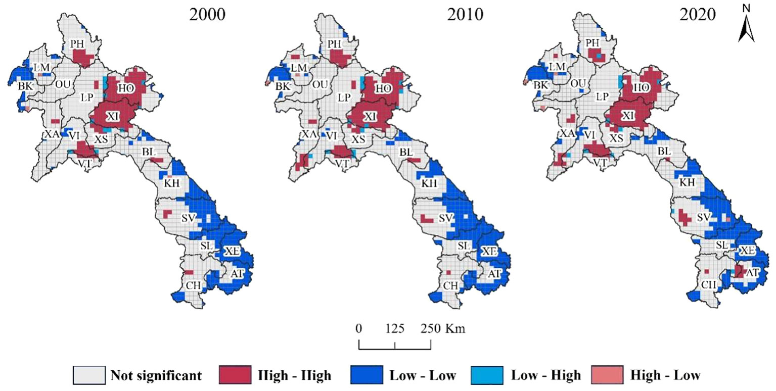
Figure 7 Map of local autocorrelation in ecological hazard in Laos from 2000 to 2020. PH, Phongsali; LM, Louang Namtha; BK, Bokeo; OU, Oudomsai; LP, Louangphrabang; HO, Houaphan; XA, Xaignabouri; VI, Viangchan; XI, Xiangkhoang; XS, Xaisomboun; VT, Vientiane; BL, Bolikhamxai; KH, Khammouan; SL, Saravan; SV, Savannakhet; XE, Xekong; CH, Champasak; AT, Attapu.
The study selected 14 natural, social, economic, and regional factors influencing landscape ecological hazard. Table 5 illustrates each factor’s relative contribution to landscape ecological hazard. The results showed that each factor significantly affected landscape ecological hazard. However, the effects of anthropogenic influences dominated the spatiotemporal evolution of landscape ecological hazard at the whole study area scale. The relative contributions of gross domestic product (GDP), distance from the town center, and distance from a road were close to or exceeded 10% over all three periods. The effect of the distance from a road on landscape ecological hazard showed a rising trend over the 2-decade study period. In contrast, the influences of night light and population density showed downward trends. The influences of other anthropogenic influences fluctuated, with the highest variation in GDP attributable to poverty alleviation policies implemented in Laos in 2010 (Phimphanthavong, 2013). Natural influences had little impact on overall landscape ecological hazard in Laos from 2000 to 2020 due to forest dominating the landscape (79.5%), followed by cultivated land (10.6%) and grassland (8.3%). Among natural influences, annual precipitation, annual average temperature, soil organic matter content, vegetation coverage, distance from protected areas, and distance from water had significant impacts on ecological hazard of Laos of between 5% and 10%. The relatively high influence of annual precipitation on the ecological hazard in 2010 could be attributed to extensive flooding on the Vientiane Plain and in Zhanbasai (Baiyinbaoligao et al., 2020). There were increasing trends in the impacts of annual average temperature, vegetation coverage, distance from protected areas, and distance from water on ecological hazard. This result could be attributed to alterations in land use due to anthropogenic endeavors (Sunderlin, 2006; Lestrelin et al., 2012). Elevation and slope showed minimal impacts on ecological hazard in Laos, mainly due to the area’s inaccessibility with significant elevation differences and a high slope preventing agricultural development and human settlement (Wang et al., 2019). However, the impact of natural influences on ecological hazard in Laos will continue to increase with increasing societal demands and the intensification of anthropogenic endeavors. While natural and anthropogenic influences affected the spatiotemporal changes in landscape ecological hazard in the study area, anthropogenic endeavors were the main drivers of deterioration in landscape ecological hazard.

Table 5 Factors influencing landscape ecological hazard (%) in Laos between 2000 and 2020.
The large scale of the study area (Kapustka et al., 2001) prevents the comprehensive analysis of factors influencing landscape ecological hazard. Therefore, the present study analyzed local characteristics of landscape ecological hazard. The minimum landscape ecological hazard index in 2020 (0.12) was used as a threshold in the analysis, in which the change in the ecological hazard index between 2000 and 2020 of > 0.12,< −0.12, and between −0.12 and 0.12 indicated an increase, decrease, and no change in landscape ecological hazard, respectively. Ten areas that showed increased landscape ecological hazard was categorized as critical areas of ecological hazard (Figure 8). The factors influencing ecological hazard in these ten areas (a–j) were then identified. The results showed that interacting natural influences were drivers of ecological hazard, with human socioeconomic factors also playing important roles. As shown in Table 6, GDP had the highest impacts on ecological hazard in b, e, and g. The deterioration in ecological hazard in b was at the junction of BK and XA provinces in the economic zone of the Golden Triangle. Commercial mining of gems and gold constitutes significant local economic activities (Kyophilavong, 2009). The area of deterioration in e spanned XA and VI provinces. These areas have rich wood and lignite resources and host important crop production areas (Pathammavong et al., 2017). The area of deterioration in g was in central and western SV province. SV province contains the second largest city in Laos, after Vientiane, and adjacent to Thailand. This region hosts intense economic activities, particularly near the Mekong River and the local bus terminal (Fujita and Phanvilay, 2008). “Distance from the town center” had the highest effect on ecological hazard in northern CH province. This area constitutes an important political and economic center in Laos with a rich historical and natural heritage. Consequently, this area has a prosperous tourism industry. “Distance from road” had the most impact on ecological hazard in b, c, and i. Areas b and c are experiencing rapid economic development, which has in turn led to investment in road infrastructure. The area of extreme ecological hazard in i hosts a vital highway that connects Laos with Thailand, Cambodia, and Vietnam. In particular, the opening of the Laos-Japan Bridge across the Mekong River that connects the Polofen Plateau, Thailand, and Si Phan Don has resulted in increased trade between Laos and Thailand and a flourishing Talat Sao Heung market near the bridge (Pathammavong et al., 2017). “Distance from a protected area” had the most enormous impact on ecological hazard in g. This area hosts significant natural resources and is adjacent to protected areas, including the Xe Bang Nouan National Biodiversity Reserve in the south, the Dong Phou Vieng National Reserve in the southeast, and the Phou Xang He National Reserve in the north. “Distance from water” had the most considerable impact on ecological hazard in c in north-central XA province. This is the only area in Laos to the west of the Mekong River and is a flat floodplain. This area hosts the largest lake in Laos (Pokhrel et al., 2018). “Night light” and “population density” showed minimal impacts on ecological hazard. Among natural influences, “elevation” had significant impacts on the ecological hazard in c, i, and j; “slope” in c and h; “annual precipitation” in e and j; “annual average temperature” in b, c and j; “vegetation coverage” in c and j; “soil organic matter content” in f and j. The mountainous terrain restricted the rapid expansion of urbanization in b and c. These areas had scattered construction land and relatively concentrated anthropogenic endeavors, resulting in high landscape disturbance. Anthropogenic influences had significant impacts on landscape ecological hazard. The proximity of natural and artificial landscape patches formed a barrier to urban expansion in g. Increased ecological hazard in j was driven by both natural and anthropogenic influences. The natural influences included “elevation”, “annual precipitation”, “annual average temperature”, and “vegetation coverage”. Anthropogenic influences included ““distance from the town center” and “distance from the road”. In summary, at a local scale, landscape ecological hazard was affected by both human and natural influences, although the former dominated.
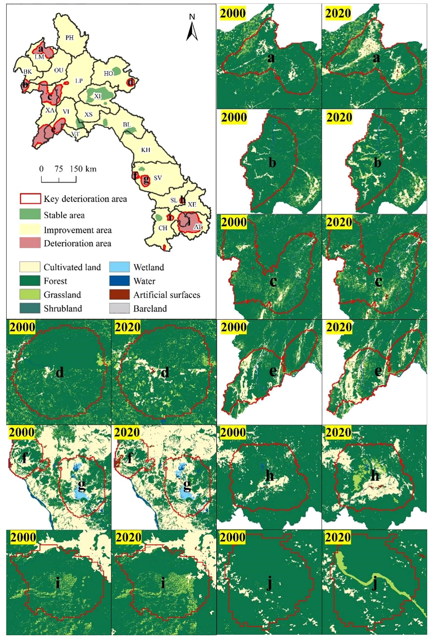
Figure 8 Changes in landscape ecological hazard in ecological conservation area in Laos and changes in land cover in deteriorating areas between 2000–2020. PH, Phongsali; LM, Louang Namtha; BK, Bokeo; OU, Oudomsai; LP, Louangphrabang; HO, Houaphan; XA, Xaignabouri; VI, Viangchan; XI, Xiangkhoang; XS, Xaisomboun; VT, Vientiane; BL, Bolikhamxai; KH, Khammouan; SL, Saravan; SV, Savannakhet; XE, Xekong; CH, Champasak; AT, Attapu. Ten areas (a–j) that showed increased landscape ecological hazard were categorized as critical areas of ecological hazard.
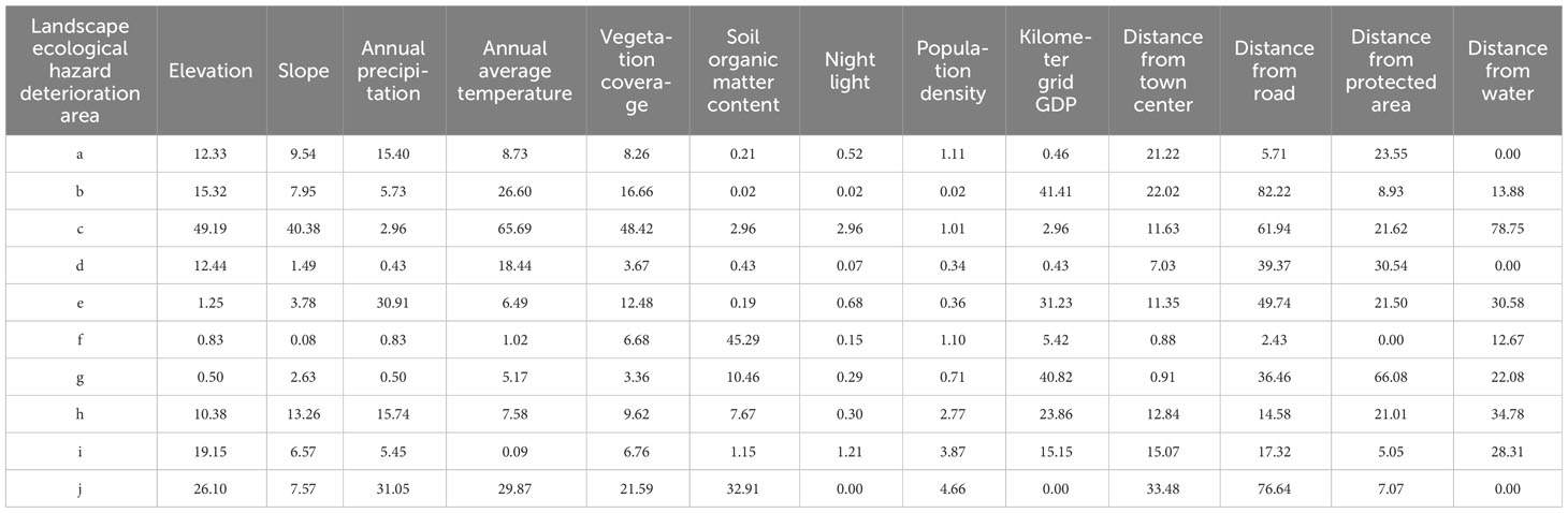
Table 6 Factors affecting landscape ecological hazard (%) in Laos between 2000 and 2020.
Alterations in land use/cover are essential drivers of global environmental change and impact ecosystem services and biodiversity, thereby contributing to landscape ecological hazard (Wang et al., 2021). Previous studies (Lin et al., 2018; Zhang et al., 2018; Hoque et al., 2020) have shown that alterations in land use/cover directly drive ecological hazard. Therefore, assessment of the impacts of potential alterations in land use/cover on the ecological environment can assist in the optimization of land use for the management of ecological hazard. The prediction of alterations in land use/cover under various scenarios can help formulate management strategies to minimize ecological hazard. The most comprehensive evaluation of landscape indices and ecological hazard is based on land use/cover (Li et al., 2020). Alterations in land use/cover driven by intense socioeconomic activities can change landscape patterns and processes, impacting ecological hazard. A fundamental dynamic relationship exists between internal drivers and alterations in land use/cover.
Changes in landscape patterns are driven by changes to ecological processes under natural or anthropogenic influences (Chen et al., 2013). The evolution of landscape patterns typically shows spatial heterogeneity and scale dependence (Kapustka et al., 2001). An in-depth study of the correlation between patterns of landscape and ecological process must consider the scale effect. This is because there is a need to focus on spatial structure and ecological process within landscape ecological hazard assessment, and the accuracy of the assessment depends on the choice of scale (Chen et al., 2022). Scale effects within patterns of landscape have remained an essential topic within landscape ecology research. Past related studies have focused on scale rules governing changes in landscape patterns and the construction of scale analysis methods. The study of the impact of scale in landscape ecology typically requires the consideration of two essential aspects, namely spatial resolution and extent (Suter, 1990), with the former relating to the spatial resolution of land use data and the latter to the size of the research units (Hunsaker et al., 1990). Recent studies on scale effects on landscape patterns have focused on spatial resolution, while there have been relatively few studies on the impact of spatial extent. There have been even fewer studies that have researched both aspects (Bayliss et al., 2012), and the few existing studies have primarily been conducted at watershed and urban landscape scales (Hope, 2006). The selection of an appropriate scale is vital for studying the scale effect, as the selection of a scale that is too large or too small can result in essential landscape details being ignored and too much focus on local processes (Peng et al., 2014). Quantitative studies of landscape pattern should fully consider factors affecting the landscape pattern index and the characteristics of landscape data. This is because the responses of different landscape pattern indices to scale effect differ as they are impacted by specific factors. Addressing the above complexity requires a multi-scale comprehensive evaluation focusing on an in-depth exploration of the scale effects of different influencing factors.
There has always been a focus on analyzing driving mechanisms of landscape ecological hazard within landscape ecology research (Qu et al., 2021). This analysis can help understand the evolution of landscape patterns for achieving sustainable development (Banks-Leite et al., 2022). However, the complexity of ecosystems prevents clear identification of direct drivers of the evolution of landscape patterns. Past studies have mainly applied correlation analysis to identify factors influencing landscape ecological hazard (Suter, 1990). Many studies have focused on the drivers of landscape ecological hazard conducted at different scales (Lin et al., 2021; Qu et al., 2021; Ai et al., 2022). These studies have shown that 60% of landscape ecological hazard can be attributed to human socioeconomic activities, whereas the remaining 40% is related to climate change. The results of the present study showed that the evolution of landscape ecological hazard in Laos over the last 20 years has been driven by both natural and anthropogenic influences. At a whole study area level, natural influences had the highest impact on the evolution of landscape ecological hazard, whereas anthropogenic influences had the most substantial local impacts. While past studies have resulted in a basic understanding of factors affecting landscape ecological hazard in Laos, the key factors driving landscape ecological hazard differ among regions. The present study identified factors affecting local landscape ecological hazard and the underlying driving mechanisms.
The results of the present study showed that changes in the structure and quality of landscape forest, grassland, and cultivated land were critical to the ecological stability of Laos. The areas of different landscape ecological hazard face different challenges and pressures due to differences in natural and socioeconomic conditions. Therefore, these areas should adopt risk prevention and environment governance strategies suited to local conditions: (1) Areas of high and extreme ecological hazard should strengthen the conservation and restoration of forest, grassland, and cultivated land. These efforts should include biodiversity conservation, the return to forest and grassland of farmland, and comprehensive management of soil erosion and desertification; (2) Transformations occurring in areas of moderate ecological hazard are more complex, and these areas have weak ecological stability. Within these areas, there is a need to increase the connections between forest, grassland, and various landscape types to facilitate afforestation and grass cover. These efforts can help reduce the rate at which areas of moderate ecological hazard transfer to areas of high ecological hazard; (3) There are extensive forest areas in regions of low and minimal ecological hazard. Regardless, these areas face challenges of a simple forest structure and degradation of soil, water, and other ecological functions. There is a need to increase the resilience of the ecological environment in these regions by regulating the intensity of development and continuously improving the ecological environment.
The present study focused on Laos and constructed a landscape ecological hazard evaluation model utilizing a landscape pattern index. This model was used to analyze the spatiotemporal evolution of landscape ecological hazard and used geodetector to measure the degrees to which natural factors, social and economic factors, and regional accessibility factors explained localized and overall landscape ecological hazard in the study area. The factors influencing landscape ecological hazard were explored from global and local perspectives. The results of the present study are summarized below.
(1) Natural and anthropogenic stresses were drivers of changes to the area and number of patches of each landscape type, which in turn resulted in changes in the corresponding landscape type index. Landscape patch number reflected the heterogeneity of the landscape and showed a specific positive correlation with the fragmentation index. During the study period, the main land cover types in Laos were forest, cultivated land, and grassland. Changes in landscape types were higher between 2000 and 2020, with decreases in the area of forest (7123.84 km2) and increases in the areas of other landscape types categorized as artificial surfaces. Areas of landscape types categorized as cultivated land and artificial surfaces increased significantly, which resulting in a transition from small, dispersed patches of landscape types to concentrated, contiguous, larger patches of landscape. Concurrently, the spatial aggregation of the landscape gradually increased, whereas wetland showed the highest abruption and fragmentation indices. Elevation showed an inverse relationship to spatial aggregation of the landscape. The other types of landscape patterns in the study area remained mostly stable.
(2) Areas of high ecological hazard were concentrated in central and northeastern Laos, whereas areas of low ecological hazard were concentrated in the northwest and southeast. There was an overall increase in average landscape ecological hazard in Laos over the study period, corresponding to a deterioration in the overall ecological status. The areas of high and extreme ecological hazard increased, whereas areas of low and minimal ecological hazard decreased. Transformations occurring in areas of moderate ecological hazard were relatively complex, thereby necessitating the need to focus on avoiding further deterioration due to fragmentation of landscape patches. The development of forestry and agriculture in the study area, needs to consider maintaining the original landscape as much as possible. In addition, there should be a focus on reducing the spatial scales of forestry and agriculture through intensive farming methods, which can increase the industrialization of agriculture and forestry while facilitating improved conservation of the local landscape environment.
(3) There were significant positive spatial correlations in the landscape ecological hazard index with relative stability in high- and low-value aggregation areas. There were significant differences between the spatial distributions of ecological pressure and ecological response, and ecological hazard in some areas was affected by multiple factors. Under the current landscape structure, there is a need to increaser ecological management in critical areas by optimizing resource allocation, conserving the natural environment, and ensuring sustainable development in a stable direction. The drivers of landscape aggregation in areas lower economic value and lower agglomeration in Laos remain poorly understood due to limited knowledge, indicating the need for further studies.
(4) The factors driving changes to land use patterns and landscape ecological hazard in Laos are interdependent and interact. At a national scale, natural factors had little impact on landscape ecological hazard in Laos, whereas human factors played a dominant role. The evolution of landscape ecological hazard in Laos is a function of the joint influences of natural and human factors. The present study restricted factor detection analysis to the application of a geodetector for identifying the contributions of influencing factors. However, the interactions between factors were not considered. Future research should further study the individual and interactive impacts of factors on landscape ecological hazard. Concurrently, future studies should focus on mechanisms of interaction between landscape ecological hazard and ecological processes and the ecological consequences, thereby increasing the practical significance of such studies.
The original contributions presented in the study are included in the article/supplementary material. Further inquiries can be directed to the corresponding author.
JM: Conceptualization, Data curation, Methodology, Software, Validation, Writing – original draft. VK: Conceptualization, Validation, Writing – review & editing. JW: Conceptualization, Methodology, Validation, Writing – review & editing. JZ: Investigation, Software, Visualization, Writing – review & editing. WL: Data curation, Formal Analysis, Visualization, Writing – review & editing. XZ: Formal Analysis, Visualization, Writing – review & editing.
The author(s) declare financial support was received for the research, authorship, and/or publication of this article. Details of all funding sources should be provided, including grant numbers if applicable. Please ensure to add all necessary funding information, as after publication this is no longer possible. This research was funded by the Multi-Government International Science and Technology Innovation Cooperation Key Project of the National Key Research and Development Program of China for the “Environmental monitoring and assessment of land use/land cover change impact on ecological security using geospatial technologies” (2018YFE0184300), the National Natural Science Foundation of China (41961060), and the China Scholarship Council (202008090261).
Thanks to the Academic Editor, and the Editor. In addition, we also want to thank the Program for Innovative Research Team (in Science and Technology) in the University of Yunnan Province [grant number IRTSTYN].
The authors declare that the research was conducted in the absence of any commercial or financial relationships that could be construed as a potential conflict of interest.
All claims expressed in this article are solely those of the authors and do not necessarily represent those of their affiliated organizations, or those of the publisher, the editors and the reviewers. Any product that may be evaluated in this article, or claim that may be made by its manufacturer, is not guaranteed or endorsed by the publisher.
Ai J., Yu K., Zeng Z., Yang L., Liu Y., Liu J. (2022). Assessing the dynamic landscape ecological risk and its driving forces in an island city based on optimal spatial scales: Haitan Island, China. Ecol. Indic. 137, 108771. doi: 10.1016/j.ecolind.2022.108771
Anselin L. (1996). Interactive Techniques and Exploratory Spatial Data Analysis (West Virginia University: Regional Research Institute Working Papers).
Anselin L. (2003). An introduction to spatial autocorrelation analysis with GeoDa (Champagne-Urbana, Illinois: Spatial Analysis Laboratory, University of Illinois). Available at: https://www.semanticscholar.org/paper/Interactive-Techniques-and-Exploratory-Spatial-Data-Anselin/1ff35696e7a12a09cf95abbb2778717c4e23cb73.
Bai H., Weng L. (2023). Ecological security pattern construction and zoning along the China-Laos Railway based on the potential-connectedness-resilience framework. Ecol. Indic. 146, 109773. doi: 10.1016/j.ecolind.2022.109773
Baiyinbaoligao, Liu H., Chen X., Mu X. (2020). “Overview of the Mekong River Basin,” Flood Prevention and Drought Relief in Mekong River Basin. Singapore: Springer. 1–25.
Banks-Leite C., Betts M. G., Ewers R. M., Orme C. D. L., Pigot A. L. (2022). The macroecology of landscape ecology. Trends Ecol. Evol. 37, 480–487. doi: 10.1016/j.tree.2022.01.005
Bartell S. M. (2006). Biomarkers, bioindicators, and ecological risk assessment—A brief review and evaluation. Environ. Bioindicators. 1, 60–73. doi: 10.1080/15555270591004920
Bayliss P., van Dam R. A., Bartolo R. E. (2012). Quantitative ecological risk assessment of the Magela creek floodplain in Kakadu National Park, Australia: comparing point source risks from the ranger uranium mine to diffuse landscape-scale risks. Hum. Ecol. Risk Assess. 18, 115–151. doi: 10.1080/10807039.2012.632290
Castella J. C., Lestrelin G., Hett C., Bourgoin J., Fitriana Y. R., Heinimann A., et al. (2013). Effects of landscape segregation on livelihood vulnerability: Moving from extensive shifting cultivation to rotational agriculture and natural forests in northern Laos. Hum. Ecol. 41, 63–76. doi: 10.1007/s10745-012-9538-8
Chapman P. M., Fairbrother A., Brown D. (1998). A critical evaluation of safety (uncertainty) factors for ecological risk assessment. Environ. Toxicol. Chem. 17, 99–108. doi: 10.1002/etc.5620170112
Chen S., Chen B., Fath B. D. (2013). Ecological risk assessment on the system scale: A review of state-of-the-art models and future perspectives. Ecol. Modell. 250, 25–33. doi: 10.1016/j.ecolmodel.2012.10.015
Chen Y., Wang J., Kurbanov E., Thomas A., Sha J., Jiao Y., et al. (2022). Ecological security assessment at different spatial scales in central Yunnan Province, China. PloS One 17, e0270267. doi: 10.1371/journal.pone.0270267
Diniz-Filho J. A. F., Bini L. M., Hawkins B. A. (2003). Spatial autocorrelation and red herrings in geographical ecology. Glob Ecol. Biogeogr. 12, 53–64. doi: 10.1046/j.1466-822X.2003.00322.x
Fujita Y., Phanvilay K. (2008). Land and forest allocation in Lao People’s Democratic Republic: comparison of case studies from community-based natural resource management research. Soc. Nat. Resour. 21, 120–133. doi: 10.1080/08941920701681490
Gao L., Tao F., Liu R., Wang Z., Leng H., Zhou T. (2022). Multi-scenario simulation and ecological risk analysis of land use based on the PLUS model: A case study of Nanjing. Sustain Cities Soc 85, 104055. doi: 10.1016/j.scs.2022.104055
Gong J., Cao E., Xie Y., Xu C., Li H., Yan L. (2021). Integrating ecosystem services and landscape ecological risk into adaptive management: Insights from a western mountain-basin area, China. J. Environ. Manage. 281, 111817. doi: 10.1016/j.jenvman.2020.111817
Hengl T. (2009). “A practical guide to geostatistical mapping,” in Extended edition of the EUR 22904 EN Scientific and Technical Research series report published by 10 Office for Official Publications of the European Communities, 2nd edn(Luxembourg: Geoderma, Elsevier BV), 293. Available at: https://www.semanticscholar.org/paper/A-Practical-Guide-to-Geostatistical-Mapping-Hengl/756c4f3e378febc3978210934e2e3fb9c67221b9.
Hope B. K. (2006). An examination of ecological risk assessment and management practices. Environ. Int. 32, 983–995. doi: 10.1016/j.envint.2006.06.005
Hoque M. Z., Cui S., Islam I., Xu L., Tang J. (2020). Future impact of land use/land cover changes on ecosystem services in the lower Meghna river estuary, Bangladesh. Sustainability 12, 2112. doi: 10.3390/su12052112
Huang Q., Zhu X., Liu C., Wu W., Liu F., Zhang X. (2020). Spatial-temporal evolution and determinants of the belt and road initiative: A maximum entropy gravity model approach. Chin. Geogr. Sci. 30, 839–854. doi: 10.1007/s11769-020-1144-x
Hunsaker C. T., Graham R. L., Suter G. W. II, O’Neill R. V., Barnthouse L. W., Gardner R. H. (1990). Assessing ecological risk on a regional scale. Environ. Manage. 14, 325–332. doi: 10.1007/BF02394200
Kapustka L. A., Galbraith H., Luxon M., Yocum J. (2001). Using landscape ecology to focus ecological risk assessment and guide risk management decision-making. Toxicol. Ind. Health 17, 236–246. doi: 10.1191/0748233701th121oa
Koenig W. D. (1999). Spatial autocorrelation of ecological phenomena. Trends Ecol. Evol. 14, 22–26. doi: 10.1016/S0169-5347(98)01533-X
Kyophilavong P. (2009). “Mining sector in Laos,” in Major Industries and Business Chance in CLMV Countries BRC Report (Thailand: Bangkok Research Center (BRC), vol. 2. , 69–100. Available at: https://www.researchgate.net/publication/281693388_Mining_Sector_in_Laos.
Lestrelin G., Castella J. C., Bourgoin J. (2012). Territorialising sustainable development: The politics of land-use planning in Laos. J. Contemp Asia. 42, 581–602. doi: 10.1080/00472336.2012.706745
Li J., Pu R., Gong H., Luo X., Ye M., Feng B. (2017). Evolution characteristics of landscape ecological risk patterns in coastal zones in Zhejiang province, China. Sustainability 9, 584. doi: 10.3390/su9040584
Li W., Wang Y., Xie S., Sun R., Cheng X. (2020). Impacts of landscape multifunctionality change on landscape ecological risk in a megacity, China: A case study of Beijing. Ecol. Indic. 117, 106681. doi: 10.1016/j.ecolind.2020.106681
Li J., Wang J., Zhang J., Liu C., He S., Liu L. (2022). Growing-season vegetation coverage patterns and driving factors in the China-Myanmar Economic Corridor based on Google Earth Engine and geographic detector. Ecol. Indic. 136, 108620. doi: 10.1016/j.ecolind.2022.108620
Liang Y., Li S., Zeng J., Wu T. (2022). Examining the impact of multidimensional accessibility on regional poverty in Laos. Appl. Geogr. 148, 102789. doi: 10.1016/j.apgeog.2022.102789
Lin D., Liu F., Zhang J., Hao H., Zhang Q. (2021). Research progress on ecological risk assessment based on multifunctional landscape. J. Resour Ecol. 12, 260–267. doi: 10.5814/j.issn.1674-764x.2021.02.012
Lin X., Xu M., Cao C. P., Singh R., Chen W., Ju H. (2018). Land-use/land-cover changes and their influence on the ecosystem in Chengdu City, China during the period of 1992–2018. Sustainability 10, 3580. doi: 10.3390/su10103580
Liu L., Li J., Wang J., Liu F., Cole J., Sha J., et al. (2022). The establishment of an eco-environmental evaluation model for southwest China and eastern South Africa based on the DPSIR framework. Ecol. Indic. 145, 109687. doi: 10.1016/j.ecolind.2022.109687
Liu Y. G., Wang N. L., Wang L. G., Zhao Y. Q., Wu X. B. (2013). Application of Gis in regional ecological risk assessment of water resources. Environ. Eng. Manag J. 12, 1465–1474. doi: 10.30638/eemj.2013.180
Malekmohammadi B., Rahimi Blouchi L. (2014). Ecological risk assessment of wetland ecosystems using Multi Criteria Decision Making and Geographic Information System. Ecol. Indic. 41, 133–144. doi: 10.1016/j.ecolind.2014.01.038
Munns J. W. R., Rea A. W., Suter II, G.W., Martin L., Blake-Hedges L., Crk T., et al. (2016). Ecosystem services as assessment endpoints for ecological risk assessment. Integr. Environ. Assess. Manage. 12, 522–528. doi: 10.1002/ieam.1707
Oliver M. A., Webster R. (1990). Kriging: a method of interpolation for geographical information systems. Int. J. Geogr. Inf Syst. 4, 313–332. doi: 10.1080/02693799008941549
Pathammavong B., Kenney-Lazar M., Sayaraj E. V. (2017). Financing the 450 Year Road: Land expropriation and politics A’ll the way down’in Vientiane, Laos. Dev. Change. 48, 1417–1438. doi: 10.1111/dech.12339
Paustenbach D. J. (2015). Human and Ecological Risk Assessment: Theory and Practice (Wiley Classics Library) (London: John Wiley & Sons). Available at: https://www.tandfonline.com/doi/abs/10.1080/713610025.
Peng J., Liu Y., Pan Y., Zhao Z., Song Z., Wang Y. (2014). Study on the correlation between ecological risk due to natural disaster and landscape pattern-process: review and prospect. Adv. Earth Sci. 29, 1186. doi: 10.11867/j.issn.1001-8166.2014.10.1186
Pettorelli N., Vik J. O., Mysterud A., Gaillard J. M., Tucker C. J., Stenseth N. C. (2005). Using the satellite-derived NDVI to assess ecological responses to environmental change. Trends Ecol. Evol. 20, 503–510. doi: 10.1016/j.tree.2005.05.011
Phimphanthavong H. (2013). The determinants of sustainable development in Laos. Int. J. Acad. Res. Manage. (IJARM). 3, 2296–1747.
Pokhrel Y., Burbano M., Roush J., Kang H., Sridhar V., Hyndman D. W. (2018). A review of the integrated effects of changing climate, land use, and dams on Mekong River hydrology. Water 10, 266. doi: 10.3390/w10030266
Qu Y., Zong H., Su D., Ping Z., Guan M. (2021). Land use change and its impact on landscape ecological risk in typical areas of the Yellow River Basin in China. Int. J. Environ. Res. Public Health 18, 11301. doi: 10.3390/ijerph182111301
Ran P., Hu S., Frazier A. E., Qu S., Yu D., Tong L. (2022). Exploring changes in landscape ecological risk in the Yangtze River Economic Belt from a spatiotemporal perspective. Ecol. Indic. 137, 108744. doi: 10.1016/j.ecolind.2022.108744
Su S., Xiao R., Jiang Z., Zhang Y. (2012). Characterizing landscape pattern and ecosystem service value changes for urbanization impacts at an eco-regional scale. Appl. Geogr. 34, 295–305. doi: 10.1016/j.apgeog.2011.12.001
Sunderlin W. D. (2006). Poverty alleviation through community forestry in Cambodia, Laos, and Vietnam: An assessment of the potential.. For. Policy Econ. 8, 386–396.
Suter II, G.W. (1990). Endpoints for regional ecological risk assessments. Environ. Manage. 14, 9–23. doi: 10.1007/BF02394015
Suter II, G.W. (2001). Applicability of indicator monitoring to ecological risk assessment. Ecol. Indic. 1, 101–112. doi: 10.1016/S1470-160X(01)00011-5
Wang H., Liu X., Zhao C., Chang Y., Liu Y., Zang F., et al. (2021). Spatial-temporal pattern analysis of landscape ecological risk assessment based on land use/land cover change in Baishuijiang National Nature Reserve in Gansu Province, China. Ecol Indic. 124, 107454.
Wang J., Sui L., Yang X., Wang Z., Ge D., Kang J., et al. (2019). Economic globalization impacts on the ecological environment of inland developing countries: A case study of Laos from the perspective of the land use/cover change. Sustainability 11, 3940. doi: 10.3390/su11143940
Xu X., Peng Y., Qin W. (2023). Simulation, prediction and driving factor analysis of ecological risk in Savan District, Laos. Front. Environ. Sci. 10, 1058792. doi: 10.3389/fenvs.2022.1058792
Yanes A., Botero C. M., Arrizabalaga M., Vásquez J. G. (2019). Methodological proposal for ecological risk assessment of the coastal zone of Antioquia, Colombia. Ecol. Eng. 130, 242–251. doi: 10.1016/j.ecoleng.2017.12.010
Zhang W., Chang W. J., Zhu Z. C., Hui Z. (2020). Landscape ecological risk assessment of Chinese coastal cities based on land use change. Appl. Geogr. 117, 102174. doi: 10.1016/j.apgeog.2020.102174
Zhang D., Jing P., Sun P., Ren H., Ai Z. (2022). The non-significant correlation between landscape ecological risk and ecosystem services in Xi’an Metropolitan Area, China. Ecol. Indic. 141, 109118. doi: 10.1016/j.ecolind.2022.109118
Zhang F., Yushanjiang A., Wang D. (2018). Ecological risk assessment due to land use/cover changes (LUCC) in Jinghe County, Xinjiang, China from 1990 to 2014 based on landscape patterns and spatial statistics. Environ. Earth Sci. 77, 491. doi: 10.1007/s12665-018-7676-z
Zhang S., Zhong Q., Cheng D., Xu C., Chang Y., Lin Y., et al. (2022). Landscape ecological risk projection based on the PLUS model under the localized shared socioeconomic pathways in the Fujian Delta region. Ecol. Indic. 136, 108642. doi: 10.1016/j.ecolind.2022.108642
Keywords: landscape ecological hazard, landscape pattern, spatial autocorrelation, geodetector, risk management, Laos
Citation: Ma J, Khromykh V, Wang J, Zhang J, Li W and Zhong X (2023) A landscape-based ecological hazard evaluation and characterization of influencing factors in Laos. Front. Ecol. Evol. 11:1276239. doi: 10.3389/fevo.2023.1276239
Received: 11 August 2023; Accepted: 30 November 2023;
Published: 15 December 2023.
Edited by:
Maged Marghany, Syiah Kuala University, IndonesiaReviewed by:
Imen Ben Salem, Zayed University, United Arab EmiratesCopyright © 2023 Ma, Khromykh, Wang, Zhang, Li and Zhong. This is an open-access article distributed under the terms of the Creative Commons Attribution License (CC BY). The use, distribution or reproduction in other forums is permitted, provided the original author(s) and the copyright owner(s) are credited and that the original publication in this journal is cited, in accordance with accepted academic practice. No use, distribution or reproduction is permitted which does not comply with these terms.
*Correspondence: Jinliang Wang, amx3YW5nQHlubnUuZWR1LmNu
Disclaimer: All claims expressed in this article are solely those of the authors and do not necessarily represent those of their affiliated organizations, or those of the publisher, the editors and the reviewers. Any product that may be evaluated in this article or claim that may be made by its manufacturer is not guaranteed or endorsed by the publisher.
Research integrity at Frontiers
Learn more about the work of our research integrity team to safeguard the quality of each article we publish.