 Ran Duan1
 Rui Tang
 Jiafu Su
94% of researchers rate our articles as excellent or good
Learn more about the work of our research integrity team to safeguard the quality of each article we publish.
Find out more
ORIGINAL RESEARCH article
Front. Ecol. Evol. , 28 September 2023
Sec. Interdisciplinary Climate Studies
Volume 11 - 2023 | https://doi.org/10.3389/fevo.2023.1243778
Industrial parks play a pivotal role in driving urban economic growth in China, particularly in light of the country's extensive mountainous terrain. Effective arrangement of supporting facilities within these parks is crucial for steering industries towards high-quality development. However, the intricate topography of mountainous regions presents challenges in devising optimal layouts for these facilities. This article adopts a user-centric perspective to investigate the impact of mountainous terrain on user fatigue within industrial parks. We employ equivalent coefficient methods to establish a correlation between undulating paths in mountainous terrain and flat paths. This correlation serves as the foundation for a visual analytical tool designed to facilitate the rational placement of supporting facilities in mountainous industrial parks. To validate our approach, we conduct an empirical analysis of the supporting facility layout at Chongqing Dadi Industrial Park. The insights gleaned from our study provide a basis for optimizing the placement of supporting facilities in mountainous industrial parks, enhancing user experiences and aligning with urban growth trajectories. In conclusion, our research offers dual benefits: firstly, it provides a scientific framework for guiding the rational layout of supporting facilities in mountainous industrial parks, addressing the challenges posed by complex terrain. Secondly, it offers practical insights into the comprehensive planning and design of these parks, promoting sustainable urban and economic growth. Our research thus emerges as a valuable resource for the advancement and optimization of mountainous industrial parks in China.
The construction of emerging industrial parks has become an important development direction for the urban economy. Emerging industrial parks place a heightened emphasis on nurturing nascent sectors during their formative phase, with a pronounced focus on knowledge-intensive endeavors as the cornerstone of growth (He, 2021; Shi et al., 2021). High-tech industries’ dominance within these parks, serving as the crux for product development and manufacturing, necessitates a distinct facility layout, divergent from that of conventional industrial parks (Wan et al., 2015; Chen, 2022). Effectively constructing supporting facilities within these parks fosters high-quality industry development. Therefore, the perfection of supporting facilities and the scientific layout are valuable research topics. The industrial parks’ supporting facilities primarily include offices, conferences, catering, and staff dormitories. This space shoulders the mantle of advanced manufacturing and distinctive service sector evolution, compelling these occupants to meticulously scrutinize and innovate the functional composition of park spaces. This also gives rise to stringent requirements for the configuration of park support amenities (Chen et al., 2021). These parks, during their inception, demonstrate a proclivity toward fostering emerging industries, where knowledge-intensive projects assume a paramount role (He, 2021; Shi et al., 2021). Notably, the design of a logically structured support facility layout in mountainous industrial parks often draws inspiration from the “Code of Urban Residential Areas Planning & Design” (GB, 1993) in China.
The research regarding supporting facilities predominantly centers around factors influencing their configuration and modes. Concerning research methods for arranging these facilities within industrial parks, Feyzan (1997) introduced the concept of correlating amenity configurations with user characteristics and needs. DeVerteuil (2000), by scrutinizing the placement of public service facilities, identified the pivotal influence of layout on efficiency and equity, serving as a vital reference for this study. Various studies adopt indicators such as access, utilization, finances, and service quality to assess public service facility performance. These investigations underscored the significance of inclusivity and simplicity in shaping facility performance evaluations (Liu, 2009). Berliant et al. (2006) constructed models to probe the relationship between allocated public services and their spatial distribution, delving into their interconnected implications. Tsou et al. (2005) stressed the imperative for planners to achieve equitable allocation of public service facilities. Designers, employing spatial analysis, advocated evaluating service facility fairness through accessibility metrics. By defining precise service zones through geographic information systems (GIS) and space syntax, the quality and scope of public services can be markedly enhanced (Harrison, 2010).
Regarding theoretical research on arranging supporting facilities in industrial parks, various Chinese cities including Guangdong Province, Zhejiang Province, Yunnan Province, and Tianjin City have issued guidelines for industrial park planning and design, catering to construction needs. The design process for supporting facility layouts in mountainous cities often references designs for industrial parks in flat regions while accounting for the configuration type and service radius of these facilities. Among them, the “Chongqing Province Optimization of Industrial Park Planning and Construction Management Some Policy Measures” (General Office of Chongqing Municipal People’s Government, 2020) from the General Office of Chongqing Municipal People’s Government has relaxed construction area controls previously applicable to supporting facilities. The previous limitations of both supporting facility and construction areas to 7% have been adjusted to a cap of 7% for the supporting facilities area and, according to regional planning, a maximum of 20% for the construction area as a proportion of the total construction space. In summary, there is a research gap regarding the methods and specifications for the planning and design of supportive infrastructure in mountainous industrial parks. Given the undulating terrain of mountainous areas, the service radius for the layout of supporting facilities in industrial parks differs from that in plain cities. As a result, directly copying the layout design method of flat cities is not suitable (Tao et al., 2017).
The undulating terrain of mountainous regions poses challenges to pedestrians. The layout of supporting facilities within mountainous industrial parks cannot be simply transposed from the implementation methods used in flat urban areas; instead, the undulating topography must be regarded as a significant influencing factor (Hayauchi et al., 2023). In this essay, we examined the transformation of equivalent distances between mountainous and flat spaces, considering the human walking experience. Additionally, we incorporated computer-generated visualization and simulation analyses to explore a rationalized layout for supporting facilities within the mountainous industrial parks. Situated within the central urban area of Chongqing, the Dadi Industrial Park stands as an exemplar of a prototypical mountainous innovative industrial park, possessing a degree of representativeness. We took the actual engineering project site of Chongqing Dadi Industrial Park as an example to conduct the mountain walking equivalent distance experiment and obtained the relationship of slope path equivalent distance coefficient of walking energy consumption in the mountainous park. Furthermore, we utilized a program to simulate and analyze the rational layout of supporting facilities within the mountain park. This step is crucial in facilitating the execution of the scientifically engineered design for Chongqing Dadi Industrial Park. This study innovates by investigating the equivalent coefficients between mountainous and plain terrains from the user’s perspective and applying them to the practical layout of supporting facilities in mountainous industrial parks. Both the research itself and its practical implementation possess a distinct level of value.
The spatial proximity between the origin and destination significantly influences the utilization of supporting facilities (Dijk and Wulp, 2010; Lira and March, 2021). It serves as a pivotal factor for evaluating the rationalization of transportation systems, land usage, and the arrangement of each supporting facility within the industrial parks (Gehl, 2002). Notably, the equivalent distance coefficient finds direct application in converting paths between mountainous and plain terrains. In studies concerning facility layout in mountainous regions, the extent of user fatigue while walking often acts as a criterion for assessing “spatial proximity” (Minetti et al., 2002). To establish a quantitative approach for determining the service radius length while considering terrain undulation, the equivalent distance function is introduced:
is the equivalent distance coefficient, which is defined as the ratio of the horizontal section distance to the slope of the inclined section when reaching the same degree of walking fatigue under the influence of mountainous areas, expressed as follows:
represents the equivalent distance coefficient. represents the distance of the horizontal section when the same degree of walking fatigue is reached. is the horizontal distance of the inclined section when the same degree of walking fatigue is reached.
As defined above, in order to further derive the equivalent distance coefficient, the concept of oxygen consumption is introduced. Oxygen consumption often serves as a measure to assess fatigue levels (American College of Sports Medicine, 2006). Thus, in an optimal scenario, oxygen consumption becomes a tool for evaluating “spatial proximity”, in other words, the strategic arrangement of supporting facilities. Noteworthy scholars such as Minetti and Steffen have proposed a relationship between road sections and energy consumption during comfortable walking speeds, particularly when the slope ranges from −45% to 45% (Sitte, 1990; Minetti et al., 2002; Held et al., 2023):
represents the oxygen consumption per unit weight distance L/(kg·m), and G represents the slope.
The relationship about the equivalent coefficient can be deduced from Formula 1, with the oxygen consumption per unit weight distance on the horizontal section (0) = 0.08 L/(kg·m). The calculation of the absolute value of the slope can be deduced from the calculation formula for , as follows:
represents the equivalent distance coefficient based on oxygen consumption; G represents the road slope. The quantitative research formula based on the energy consumption relationship is more complex, and the calculation results under ideal conditions. Therefore, it is impossible to study the layout of supporting facilities in mountainous industrial parks only based on the fatigue of oxygen consumption (Dijk and Wulp, 2010).
In industrial parks situated on flat terrains, the service radius of supporting facilities is typically determined by multiplying the upper limit of suitable walking distance by the detour coefficient, PDR (Stangl, 2012). Environmental issues often find resolution through experimental methodologies (Clobert et al., 2018). The detour coefficient pertains to the ratio between the actual distance and the straight-line distance due to the twists and turns in the path caused by the park’s ground texture.
The formula is as follows:
r represents the service radius taken, l represents the limiting walking distance, and PDR represents the detour coefficient.
A simple circular area is insufficient for accurately representing the appropriate service range of supporting facilities within mountainous parks (Tao et al., 2017). Due to the diverse slopes in different directions leading to varying effects on walking fatigue, we aimed to systematically develop a quantitative approach for strategically placing supporting facilities in mountainous terrain. In this regard, we presented a visual analysis method of the rational arrangement of these supporting facilities within mountainous industrial parks. The process of analysis is depicted in Figure 1.

Figure 1 Layout of supporting facilities in the mountainous industrial parks.
The walking path of the mountainous industrial parks is also influenced by the detour coefficient; with reference to Formula 6, the appropriate one-way horizontal walking distance threshold is as follows:
S represents the appropriate one-way horizontal walking distance threshold.
Assuming the planar location B of the supporting facilities, we drew the radial line with B as the center of the circle in the plane to a certain angle, and each segment was named D1 to Dn.
We projected the starting and ending points of Dn onto the terrain surface and connected the two projection points to obtain the line segment and the height difference between the two points. We can obtain the slope in the vertical direction , which is the average slope of the section:
Gn represents the slope of the road section , and represents the absolute value of the height difference between the two ends of Dn.
Taking Gn into Formula 8, the equivalent distance coefficients of road sections Dn can be obtained, and thus the equivalent walking distance of each road section in the radial direction
where stands for the road section Dn equivalent walking distance.
By accumulating , the equivalent walking distance can be obtained in the direction of radial Rm starting from point B.
The horizontal distance is represented on the X-axis, and the equivalent walking distance is indicated on the Y-axis. We establish the optimal walking distance threshold as S. When Y equals S, the corresponding horizontal distance aligns with the furthest point Pm, which is considered feasible for walking within this radial distribution. By connecting the acquired Pm points from each radiation direction, we can define a suitable service range originating from point B. Figure 1 illustrates the strategic arrangement of supporting facilities within the mountainous industrial park.
In mountainous regions, the presence of large and extended steep slopes and steps complicates the design of supporting facility layouts in parks (Jin et al., 2013). Pedestrian bridges and underpasses in these areas can span several times the walking distance of flat pathways (Zhai and Zhou, 2019). By examining the equivalent distance of ascents and descents along mountainous roads, we have developed a visualization program utilizing the programming languages Rhino and Grasshopper to logically arrange supporting facilities within the mountainous park. This enables the practical application of our research findings to the layout design of these park facilities. Rhino 7.0 is capable of creating and editing terrain surfaces, while Grasshopper 1.0.0007 facilitates modular visual programming.
The rational layout of supporting facilities in mountainous industrial parks, viewed from a user’s perspective, necessitates consideration of factors such as functionality, service objects, usage frequency, and spatial proximity (Ye et al., 2020; Han et al., 2021). In accordance with the “Urban Residential Area Planning and Design Standards”, amenities such as retail, dining, and leisure facilities should be placed within the 5-minute life circle’s service radius. Here, L0 signifies the distance achievable in a 5-minute walk, depicting the actual path distance between two points without accounting for path slope (Ren et al., 2020), while the service radius assumes the straight-line distance between points, denoted as R0 when the path slope is omitted. A visualization analysis of the mountainous park site was undertaken to regulate the theoretical PRD values within the range of 1.1 to 1.5 (Shen et al., 2020).
The program interface is categorized into three sections: input, calculation, and output. The interface of the visual analysis program for the rational facility layout is depicted in Figure 2. Within the input section, adjustments can be made to the terrain surface, the planar positions of the supporting facilities can be assumed, and the range radius, standard service radius, and ray segmentation modulus can be measured. Meanwhile, the output section allows for color adjustments of the reasonable service range surface area, along with displaying the area and coverage of the range. The calculation segment comprises standard analysis units, with each unit corresponding to a radiation line.
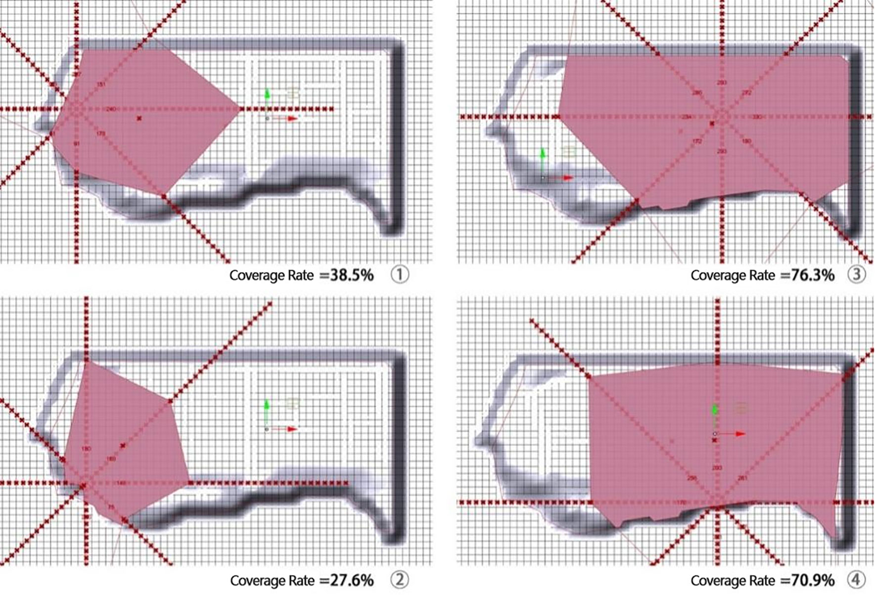
Figure 2 Program interface for layout of supporting facilities.
Chongqing, situated in southwestern China (see Figure 3), boasts an urbanization rate of 65.5%, rendering it a renowned mountainous city within the country. Its terrain is predominantly hilly and mountainous, constituting 76% of the total land area. Significantly, Chongqing holds a pivotal role in the Western Development strategy and serves as a crucial nexus between the “Belt and Road” initiative and the Yangtze River Economic Belt. The region’s ecology, as noted by Su et al. (2022), is intricate. Liangjiang New Area, encompassing 1,200 km2, falls under the jurisdiction of Chongqing City as a sub-provincial and national-level development zone. Notably, it stands as China’s first national-level new area in the inland region. Dadi Industrial Park, an integral component of this area, is situated within the Shuitu Cluster of Chongqing Liangjiang New Area. Dadi Industrial Park is an integral component of the Chongqing Liangjiang New Area’s science and technology innovation base, a key project initiated by the Ministry of Science and Technology. As a prominent biopharmaceutical-focused industrial park in Chongqing, it has successfully attracted investments from over 150 enterprises. It serves as a mountainous, medium-sized biomedical enterprise, with an expansive plot spanning 102,474 m2. This industrial park finds itself proximate to the city’s main thoroughfare to the west, urban bypasses and residential communities to the north, and additional industrial land and urban bypasses to the east. The concave flood discharge canal defines its southern border, while a city park stands opposite the flood drainage canal in the southwest. Following topographical adjustments, the park is partitioned into three distinct platforms: one on the west, another on the south, and a central platform. Notably, the west and south platforms lie in close proximity to the primary city road and the flood discharge channel, respectively. These areas exhibit an elevation of approximately 4.5 m lower than that of the central platform. The site layout can be visualized in Figure 3.
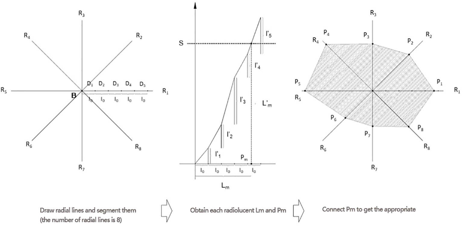
Figure 3 Location of study area.
We conducted walking experiments across diverse slope sections to quantify walkers’ perceived fatigue and derived the equivalency distance coefficient formula through data analysis. The experiment involved 10 adults, with an equal gender distribution (five men and five women), aged between 25 and 65 years. All participants were in good health without any medical history and represented the primary users of the industrial park. Five sections with different slopes were selected: Section A (0.5%), Path B (4.6%), Path C (8.3%), Path D (15.2%), and Path E (24.8%). We chose a suitable weather and time period and asked walkers to walk to and fro at their normal speed and manner. Heart rate measurements and the Brog Scale were used as auxiliary judgments to enhance the accuracy of walkers’ perception of their walking fatigue.
The experiment comprised two parts. In Experiment 1, participants were tasked with walking for 5 minutes in each section, during which we measured the walking distance, pre- and post-heart rate, and the Borg Scale. These data allowed us to analyze the impact of slope on speed and physiological indicators. For Experiment 2, participants first rated their fatigue level as P0 after a 5-minute walk in Section A. Subsequently, they proceeded to walk in Sections B, C, D, and E, notifying the experimenter upon reaching the P0 level again. We then recorded the walking time, distance, and physiological indicators for this phase.
The data of walking Experiment 1 data are shown in Table 1.
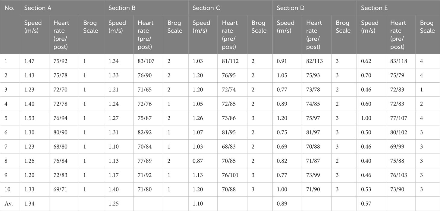
Table 1 Walking experiment 1 data.
The experimental data reveal a notable decline in walking speed from 1.34 m/s to 0.57 m/s with increasing slope, underscoring the pronounced influence of slope on walking pace. Moreover, the standard deviation rose from 0.11 m/s to 0.18 m/s, reflecting a substantial shift in magnitude while retaining a comparable absolute value. This suggests an amplified distinction in individual walking speeds as slope inclination rises. The substantial divergences in both heart rate variation and respiratory index before and after the experiment, distinctly underscoring the profound impact of slope on walking fatigue, coupled with considerable variability across individuals.
The data from walking Experiment 2 are presented in Table 2.
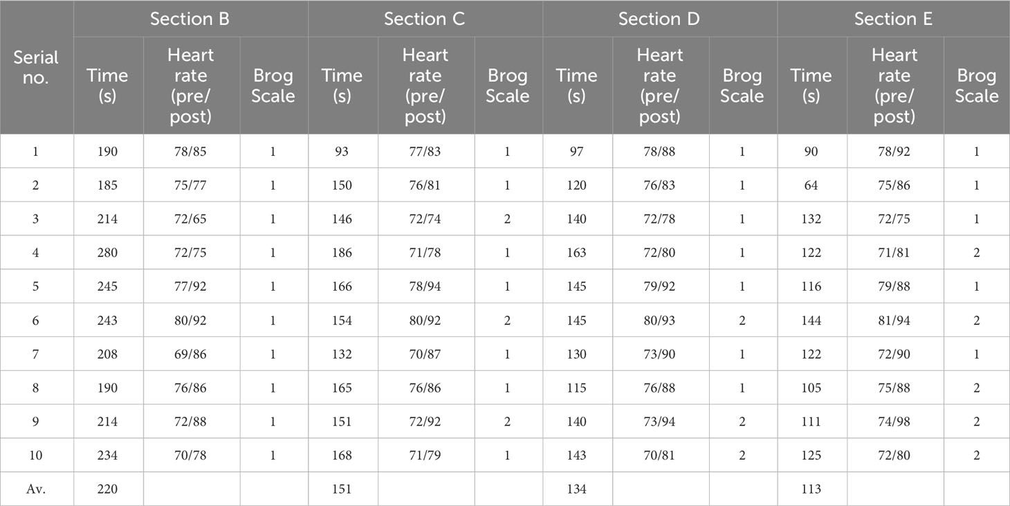
Table 2 Walking experiment 2 data.
The experimental results reveal a consistent pattern: when walkers subjectively sense they have attained fatigue level P0 in each section, both heart rate change data and the Borg Scale exhibit uniformity. This convergence supports the accuracy of their perceived walking fatigue. Analyzing the data, we observed a non-linear relationship between the time taken to reach the same fatigue level and the slope of the path. As the slope increases, the time required to reach equivalent fatigue markedly decreases, with a subsequent deceleration in the rate of shortening as the slope further steepens. The mean times recorded were 219 s, 160 s, 134 s, and 113 s, with a standard deviation of 30 s. Correspondingly, standard deviations amounted to 30 s, 25 s, 19 s, and 23 s, demonstrating a tendency to gradually decrease with slope, except between 15% and 20% where changes remained consistent.
Drawing from the outcomes of the walking experiment, we can establish an expression for equivalent walking distance for each inclined section, enabling a comparison to a horizontal section under identical 5-minute walking fatigue:
stands for the horizontal distance of 5-minute equivalent to walking fatigue of the road section with slope G relative to the horizontal road section. VG stands for the walking speed under the road section with slope G, and TG stands for the walking time of 5-minute equivalent walking fatigue under the road section with slope G relative to the horizontal road section.
It is obtained that G′ is 1.34 for a slope of 4.6%, 1.61 for a slope of 8.30%, 2.43 for a slope of 15.20%, and 3.61 for a slope of 24.80%.
The equivalence distance coefficient based on walking experiments can be obtained by fitting the data to the equation:
In the formula, the slope’s absolute value varies from −25% to 25%.
In Figure 4, we present a comparative curve analysis based on oxygen consumption and the Slope Equivalence Factor. The curves of Kie and Kiv are compared, revealing distinct trends. Notably, for slopes less than 5%, their disparities are minimal. However, these differences progressively amplify as the slope increases. For instance, at a 15% slope, Kiv registers at 2.43, while Kie stands at 2.73. This disparity continues to widen at a 25% slope, with Kiv at 3.81 and Kie at 5.05.
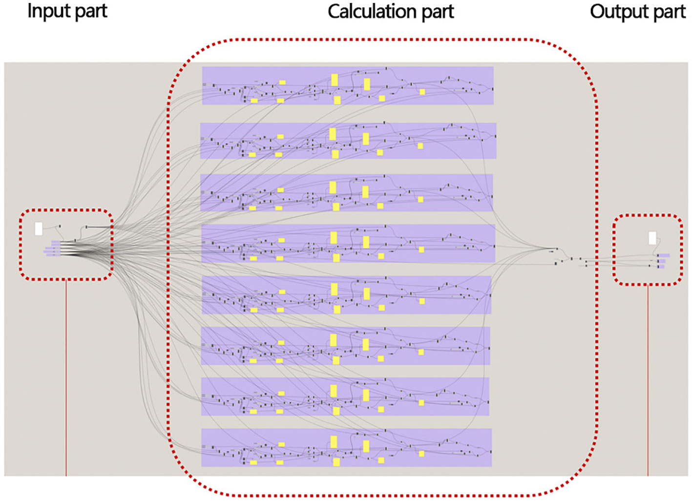
Figure 4 The comparison of the curves of and .
The data extracted from the walking experiment encapsulate the combined influence of numerous factors, encompassing the physiological and psychological effects of various environmental elements on walking fatigue. Due to its simpler outcomes, Kie is adopted as the suitable equivalent distance coefficient formula for the focal point of this research study.
In accordance with pertinent regulations, the Chongqing Dadi Industrial Park parcel allows for ancillary structures covering up to 7% of the area. These structures encompass office, recreational, and dining facilities. The layout of these supporting facilities is depicted in Figure 5, illustrating their designated positions within the park. During program deliberations, four potential locations for these supporting facilities were established, considering the urban context. Position 1 situates itself at the primary entrance square on the western terrace. Position 2 is found on the southwest terrace fortress, approximately 10 m lower in elevation compared to the western terrace, overlooking the municipal garden landscape to the south. Position 3 is centered within the park’s horizontal and vertical axes, positioned at the square within the central terrace. Finally, Position 4 is situated at the midpoint of the southern terrace, representing the park’s southernmost terrace. For clarity, the location of these supporting facilities is depicted in Figure 5.
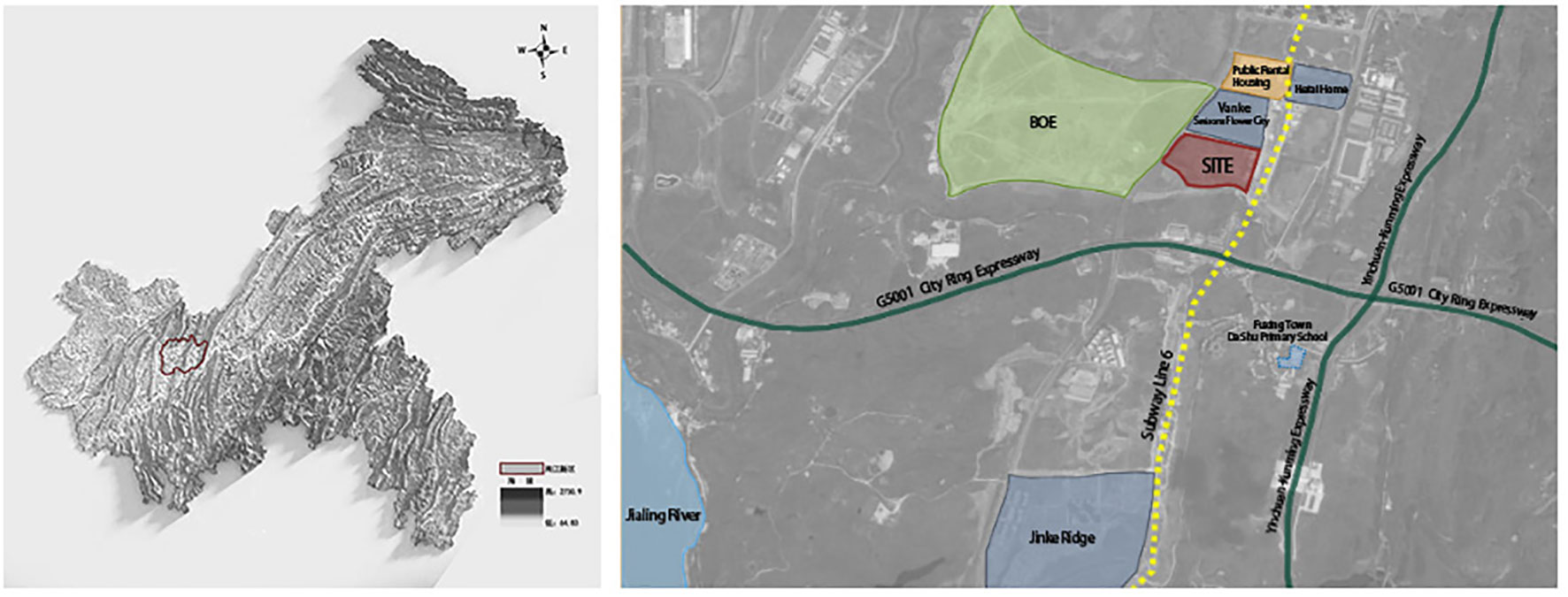
Figure 5 Preset location of supporting facilities.
The Dadi Industrial Park’s layout is analyzed utilizing a rational program for supporting facilities within the mountainous industrial park. The analysis program incorporates fundamental data like terrain surface and land redlines. The measurement range radius is input to ensure coverage of the land red line area. With the park’s basic road network, PRD is set at 1.3, and the segmentation modulus is 10 m. The results of the supporting facilities layout study in the mountainous industrial park are illustrated in Figure 6, displaying candidate locations for each service facility within the model.
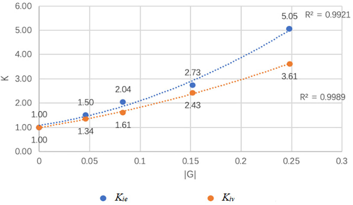
Figure 6 Planning and supporting service layout of Dadi Industrial Park.
Position 1, Position 2, Position 3, and Position 4 represent four sets of graphical data depicting the rational layout visualization of the mountainous industrial park’s supporting facilities. Position 1’s layout includes the western terrace and a smaller area of the central terrace. At Position 2, the service area comprises only 27.6% of the park, covering the southern side of the western terrace and a smaller section of the western side of the central terrace. This area is narrower compared to Position 1. Position 3’s layout covers a service area of 76.3%, encompassing most of the central and southern terraces. The supporting facilities’ service radiation range is greater. Finally, at Position 4, the service area covers 70.9%, including the central and middle parts of the southern terrace, with a smaller service radiation range than Position 3.
A comprehensive analysis of park traffic, landscape, and internal functional zoning indicates that the optimal arrangement for supporting facilities is at Position 1 and Position 3. Position 1 hosts office meetings, leisure activities, catering, and other facilities close to the city’s main road. This layout forms an independent zone while catering to the surrounding urban area. At Position 3, small-scale leisure catering is arranged primarily for park enterprises, creating a scientifically designed layout for supporting services within the park.
Utilizing software for rational supporting facility layout in the mountainous industrial parks, Dadi Industrial Park is structured with a “green axis running through, ring road around; multiple distributions, industry-city harmony” layout. Figure 6 illustrates the planning and supporting service arrangement in Locations 1 and 3. The site was analyzed and divided into three terraces on the west, south, and central sides to manage varying heights. The western and southern terraces each encompass approximately 10% of the total area, while the central terrace dominates with approximately 80%.
A central east–west green axis connects the park’s core to the main urban road, featuring three square nodes. This design, combined with the rationalized layout procedure for mountainous industrial parks supporting facilities, fosters a convenient traffic system. The main vehicular ring road and orthogonal grid road establish an accessible circulation network. The west terrace aligns with the city’s main road and rests approximately 5 m lower than the central terrace. Key supporting facilities, including office spaces, conference areas, and dining facilities, are strategically positioned along the city interface. For the south terrace, a layered approach accommodates productive spaces. The central terrace features a small-scale supporting facility hub to address coverage limitations on the west side. This comprehensive design cultivates harmonious integration with the city surroundings and promotes collaborative growth between production and support zones within the park.
This paper examines the rational layout of supporting facilities in mountainous industrial parks, focusing on the user’s viewpoint. The study delves into the undulation of mountainous roads and user fatigue, subsequently introducing an equivalent distance formula for mountainous road undulation. A visualization program is developed using software to facilitate the rationalized layout of supporting facilities in mountainous industrial parks. The research findings are implemented in the Chongqing Dadi Industrial Park supporting facilities layout and overall park planning, yielding an optimal arrangement determined by site conditions.
These research outcomes enhance the scientific and practical aspects of supporting facility layout in mountainous industrial parks. Moreover, it promotes harmonious development between production and supporting zones within the park, and seamless integration between the park and its surrounding cities. The user-centric exploration of the rational supporting facility layout in mountainous industrial parks provides both scientific guidance and pragmatic significance for facility layout and park planning in such contexts. This research holds scientific validity and practical applicability. Its findings can be extended and applied not only to the layout of supporting facilities in mountainous industrial parks but also to the spatial arrangement of other types of mountainous urban areas. It bears the potential to positively contribute to enhancing land utilization efficiency in mountainous regions, offering valuable insights for related research in these areas.
The original contributions presented in the study are included in the article/supplementary materials, further inquiries can be directed to the corresponding author/s.
RD: conceptualization and supervision. ZW: conceptualization, methodology, software, data curation, writing—original draft preparation, and writing—reviewing and editing. RT and JY: methodology, review and editing, supervision, and funding acquisition. JS: conceptualization and methodology. All authors contributed to the article and approved the submitted version.
This work was supported by the Chongqing Design Group Co., Ltd. 2023 Research Project (2023-B1); National Natural Science Foundation of China (52308038); And Chongqing Technology and Business University Graduate Innovative Research Project(yjscxx2023-211-84).
We are grateful to the research group members for their support and contribution to data collection.
Author JY was employed by the company Chongqing Design Institute Co., Ltd.
The authors declare that this study received funding from Chongqing Design Group Co., Ltd. The funder was not involved in the study design, collection, analysis, interpretation of data, the writing of this article or the decision to submit it for publication.
All claims expressed in this article are solely those of the authors and do not necessarily represent those of their affiliated organizations, or those of the publisher, the editors and the reviewers. Any product that may be evaluated in this article, or claim that may be made by its manufacturer, is not guaranteed or endorsed by the publisher.
American College of Sports Medicine (2006). ACSM’s Guidelines for Exercise Testing and Prescription. 7th ed (Philadelphia: Lippincott Williams & Wilkins).
Berliant M., Peng S., Wang P. (2006). Welfare analysis of the number and location of local public facilities. Region. Sci. Urban Econ. 36 (2), 207–226. doi: 10.1016/j.regsciurbeco.2005.06.006
Chen J. H. (2022). Industrial park update and optimization design strategy from the perspective of urban catalysts: taking Xiamen Longshan Wanwu factory as an example. South Architect. 2022 (6), 86–92. doi: 10.3969/j.issn.1000-0232.2022.06.011
Chen D. G., Ye C. D., Cai S. Q. (2021). Space utilization and transformation strategy of village-level industrial parks in Guangzhou. Guangdong Landscape Architect. 43 (05), 26–30. doi: 10.12233/j.gdyl.2021.05.006
Clobert J., Chanzy A., Le Galliard J. F., Chabbi A ., Greiveldinger L., Caquet T., et al. (2018). How to integrate experimental research approaches in ecological and environmental studies: anaEE France as an example. Front. Ecol. Evol. 43 (6). doi: 10.3389/fevo.2018.00043
DeVerteuil G. (2000). Reconsidering the legacy of urban public facility location theory in human geography. Prog. Hum. Geogr. 2000, 24(1). doi: 10.1191/030913200668094045
Dijk T. V., Wulp N. (2010). Not in my open space: Anatomy of neighbourhood activism in difference of land use conversion. Landscape Urban Plann. 96 (1), 19–28. doi: 10.1016/j.landurbplan.2010.02.001
Feyzan B. E. (1997). The distribution of urban public services: the case of parks and recreational services in Ankara. Cities 14 (6), 353–361. doi: 10.1016/S0264-2751(97)00026-7
GB (1993). Code of urban Residential Areas Planning & Design. Beijing (Beijing Haidian District Million Village Housing Construction Department: China Architecture & Building Press), 50180-93.
Gehl J. (2002). Life Between Buildings. (Beijing Haidian District Million Village Housing Construction Department: China Architecture & Building Press).
General Office of Chongqing Municipal People’s Government (2020). No. 99, Several Policies and Measures for Optimizing the Planning, Construction and Management of Industrial Parks in Chongqing Municipality (Chongqing: Chongqing Municipal People’s Government).
Han X., Shan F., Jia Y., Wang Y. B., Cao J. N. (2021). Research on the evaluation index of urban landscaping in the new era—A case study of xuzhou. Chin. Landscape Architect. 37 (12), 20–25. doi: 10.19775/j.cla.2021.12.0020
Harrison C. (2010). Exploration Assessment of the Service Distance Based on Geographical Information Systems and Space Syntax Analysis on the Urban Public Facility (Dubai, U ARAB EMIRATES: International Conference on Environmental and Computer Science).
Hayauchi G., Ariyoshi R., Morikawa T., Nakamura F. (2023). Assessment of the improvement of public transport in hillside cities considering the impact of topography on walking choices. Sustainability 2023, (15)12. doi: 10.3390/su15129571
He J. (2021). Research on the system construction of venous industry from the perspective of symbiosis. On Econ. Prob. 2021 (08), 95–103. doi: 10.16011/j.cnki.jjwt.2021.08.012
Held S., Rappelt L., Giesen R., Wiedenmann T., Deutsch J. P., Wicker P., et al. (2023). Increased oxygen uptake in well-trained runners during uphill high intensity running intervals: A randomized crossover testing. Front. Physiol. 14, 1117314. doi: 10.3389/FPHYS.2023.111731
Jin G. H., Liu X. M., Bian Y. (2013). Pedestrian physical consumption quantitative method and applications. J. Transport. Syst. Eng. Inf. Technol. 2013 (03), 157–162. doi: 10.3969/j.issn.1009-6744.2013.03.025
Lira M., March H. (2021). Learning through housing activism in Barcelona: knowledge production and sharing in neighbourhood-based housing groups. Housing Study 38 (5), 902–921. doi: 10.1080/02673037.2021.1921121
Liu Y. D. (2009). Implementing and evaluating performance measurement initiative in public leisure facilities: an action research project. Sys. Pract. Action Res. 22 (1), 15–30. doi: 10.1007/s11213-008-9103-y
Minetti A. E., Moia C., Roi G. S., Susta D., Ferretti G. (2002). Energy cost of walking and running at extreme uphill and downhill slopes. J. Appl. Physiol. 93 (3), 1039–1046. doi: 10.1152/japplphysiol.01177.2001
Ren X. T., Gao J., Zhang Y. N. (2020). Quantitative study on walking space around residential rail transit stations in Beijing. Huazhong Architect. 38 (1), 5. doi: 10.13942/j.cnki.hzjz.2020.01.007
Shen J., Chun T., Niu Q., Wei W., Peng Y. (2020). Evaluation and difference analysis of built environment walking demands in urban residential areas: A case study of five types of residential areas in Wuhan. Planners 36 (12), 38–44. doi: 10.3969/j.issn.1006-0022.2020.12.006
Shi Y. J., Han Q. M., Shen W. M., Wang X. B. (2021). A multi-layer collaboration framework for industrial parks with 5G vehicle-to-everything networks. Engineering 7 (06), 251–281. doi: 10.1016/j.eng.2020.12.021
Sitte C. (1990). The Art of Building Cities: Follow artistic principles for urban construction (No. 445 Changhong Road, Nanjing: Southeast University Press).
Stangl P. (2012). The pedestrian route directness test: A new level-of-service model. URBAN DESIGN Int. 3 (17), 228–238. doi: 10.1057/udi.2012.14
Su X., Shen Y., Xiao Y., Liu Y., Cheng H., Wan L., et al. (2022). Identifying ecological security patterns based on ecosystem services is a significative practice for sustainable development in Southwest China. Front. Ecol. Evol. 9. doi: 10.3389/fevo.2021.810204
Tao Z. L., Cheng Y., Dai T.Q. L. I. X. (2017). Sensitivity analysis of parameters in measuring spatial accessibility to public service facilities. Modern Urban Res. 2017 (03), 30–35. doi: 10.3969/j.issn.1009-6000.2017.03.005
Tsou K. W., Hung Y. T., Chang Y. L. (2005). An accessibility-based integrated measure of relative spatial equity in urban public facilities. Cities 22 (6), 424–435. doi: 10.1016/j.cities.2005.07.004
Wan M., Xie F. F., Yu Z. W. (2015). Low carbon urban design of southern area of Hong Kong industrial park. Planners 31 (09), 118–125. doi: 10.3969/j.issn.1006-0022.2015.09.020
Ye S., Zheng D. H., Chen B., Wang X. (2020). Research on the spatial accessibility of urban park green space based on service radius. Geospatlal Inf. 18 (128(04)), 73–77. doi: 10.3969/j.issn.1672-4623.2020.04.016
Keywords: mountainous industrial park, industrial park, supporting facility layout, user perspective, urban economic growth
Citation: Duan R, Tang R, Wang Z, Yang J and Su J (2023) Optimized layout of supporting facilities in mountainous industrial parks: a case study of Chongqing Dadi Industrial Park. Front. Ecol. Evol. 11:1243778. doi: 10.3389/fevo.2023.1243778
Received: 21 June 2023; Accepted: 04 September 2023;
Published: 28 September 2023.
Edited by:
Nallapaneni Manoj Kumar, City University of Hong Kong, Hong Kong SAR, ChinaReviewed by:
Tongyue Wang, Tongji University, ChinaCopyright © 2023 Duan, Tang, Wang, Yang and Su. This is an open-access article distributed under the terms of the Creative Commons Attribution License (CC BY). The use, distribution or reproduction in other forums is permitted, provided the original author(s) and the copyright owner(s) are credited and that the original publication in this journal is cited, in accordance with accepted academic practice. No use, distribution or reproduction is permitted which does not comply with these terms.
*Correspondence: Zhigang Wang, d3pnXzkyMTUwMTIyMDAwMkBjcWp6Yy5lZHUuY24=; Jiafu Su, amlhZnUuc3VAaG90bWFpbC5jb20=
Disclaimer: All claims expressed in this article are solely those of the authors and do not necessarily represent those of their affiliated organizations, or those of the publisher, the editors and the reviewers. Any product that may be evaluated in this article or claim that may be made by its manufacturer is not guaranteed or endorsed by the publisher.
Research integrity at Frontiers
Learn more about the work of our research integrity team to safeguard the quality of each article we publish.