 Xiang Li
 Yuejiao Chen1,2*
- 1College of Science, Shihezi University, Shihezi, China
- 2Corps Key Laboratory of Oasis Towns and Mountain Basin Ecosystems, Shihezi University, Shihezi, China
Since the implementation of China’s Western Development Policy, Xinjiang has experienced rapid socio-economic development and significant changes in its land use patterns. As an important factor in agricultural production, farmland is of crucial for realizing the rural revitalization strategy. Based the theoretical mechanisms of farmland use transformation, this study selected five periods of land use and socioeconomic data from 2000, 2005, 2010, 2015, and 2018 to study the spatial and temporal evolutionary characteristics of farmland use transformation in Xinjiang since China’s Western Development Policy. We then explored the driving mechanisms using an optimal geographic detector model based on parameters. The results showed that (1) Xinjiang’s farmland use transitioned toward large scale and multifunctionality, and the transition characteristics are mainly of fluctuating growth type. The spatial transformation and functional transformation characteristics were generally consistent in spatial distribution. (2) There was a spatial agglomeration in the transformation, which was concentrated in the economic zone of the northern slope of Tianshan Mountain, the Yili River Valley and Kashgar region. The concentration of functional transformation of farmland has increased, but the spatial transformation of farmland has weakened. (3) The role of influencing factors on the transformation of farmland use differed with periods. Finally, the study concluded that the functional transformation of farmland in Xinjiang since China’s Western Development Policy is still at the stage of mainly production function. We suggest that the protection of farmland in Xinjiang in the New Western Development period should be achieved by promoting the transformation of the function of farmland. The findings of this study provide decision-making assistance for the management of farmland use in Xinjiang during the New Western Development period and are an effective tool for achieving the goals of sustainable farmland use and agricultural and rural modernization.
Introduction
The implementation of China’s Western Development Policy by the Chinese government in 2000, has accelerated the industrialization of the western region, which has promoted economic growth (Zhang et al., 2019; Jia et al., 2020; Zhuo and Deng, 2020) and, has simultaneously brought several socioeconomic benefits to the central and eastern regions. Xinjiang is rich in land resources and plays an important role in the development and replenishment of farmland resource reserves, which contributes greatly to the conservation of farmland in China and the urbanization of the central-eastern region. Against the background of the general decrease of farmland in China, farmland in Xinjiang has increased annually (He et al., 2018; Zhang and Li, 2021) and has played an important role in maintaining China’s food security strategy. The quality (Sheng et al., 2021), expansion patterns (Cai et al., 2021), water use (Hu et al., 2019), and mulch pollution (Xiong et al., 2019) of Xinjiang’s farmland have attracted widespread scholarly attention, and management engineering measures such as agricultural land transfer (Wang et al., 2022; Yang and Liu, 2022) and land remediation (Liao et al., 2021) are being explored. In addition, the multifunctional value of farmland in Xinjiang has also drawn attention (Zhang et al., 2022). However, in general, current research on the use of farmland in Xinjiang focuses on a single perspective and lacks systematic research on the transformation of farmland use. Land use transformation based on land systems science combines scientific research with sectoral decision-making and can effectively translate scientific findings into land use management policies under the concept of sustainability (Long et al., 2019).
Land use transition reflects the long-term changes in land use structure and function; it is an important research component in the Global Land Project, which is essential for coordination of regional socio-economic development and ecological conservation goals (Chen et al., 2020; Long et al., 2021b). Land use transition originated from the forest transition hypothesis proposed by Mather (1992). Since then, forest transition has been the core of land use transition research (Barbier et al., 2010; Lambin and Meyfroidt, 2010; Rudel et al., 2010; Long and Qu, 2018), and it is still a hot topic of research (Barbier et al., 2017; Singh et al., 2017). Grainger proposed the concept of land use transition from the perspective of land use pattern based on forest transition, and defined it as the change of land use pattern in a certain region in the process of socio-economic development (Grainger, 1995; Song et al., 2014). Since then, the connotation of the concept of land use pattern has been continuously enriched and developed, gradually expanding to explicit patterns (quantity and spatial structure) and implicit patterns (quality, property rights, operation methods, inherent inputs, output capacity, functions, etc.) (Long and Tu, 2018; Long et al., 2020, 2021a).
As an important land use type and agricultural production factor, farmland is key to guaranteeing food security and promoting regional sustainable development. Its role in achieving the UN 2030 Sustainable Development Goals (SDGs) includes “hunger eradication” and “terrestrial ecology” (Jiang et al., 2020; Liu and Zhou, 2021; Zhou Y. et al., 2021). Therefore, the transformation of farmland use has received considerable attention from scholars. In recent years, scholars have studied the transformation of farmland use at various scales, including national, provincial, regional, and county levels. The objectives of land management differ at different scales, among which the county-level research unit is the most basic unit of land management in China (Lyu et al., 2021). In terms of research content, scholars have shifted from exploring theoretical research paths on farmland use transition (Qu and Long, 2018) to empirical evidence (Fu et al., 2020; Niu et al., 2020), specifically focusing on the driving mechanisms (Bertoni et al., 2018; Zhou X. P. et al., 2021) and various effects of farmland use transition (SHI et al., 2017; Ge et al., 2018b; Lu et al., 2019). Research on farmland use transition is generally at the “description-explanation” stage (Song et al., 2014). Most empirical studies on farmland use transition are from a single perspective (Francis et al., 2012; Bren d’Amour et al., 2017; Ge et al., 2018a; Du et al., 2021), and few scholars have focused on the comparison between explicit and implicit changes in farmland form, which is important for understanding the mechanism of farmland use transition. In addition, insufficient attention has been given to the interactions between factors that influence farmland use transformation, which may have different effects on farmland use transition in different periods. This has important implications for the accurate formulation of farmland use management policies.
In 2020, the “Guidance Opinions of the State Council of the Central Committee of the Communist Party of China on Promoting the New Era of Western Development to Form a New Pattern” was introduced, which brought about new development opportunities for Xinjiang. How to promote the transformation of farmland use management into socio-economic development in the new western development period is of practical significance to farmland conservation in Xinjiang. Research on the description of the phenomenon of farmland use transition and the driving mechanism is the basis for optimal regulation of farmland use. It is important to explore the characteristics and problems of farmland use transition in Xinjiang since China’s Western Development Policy and to identify the key factors causing these problems in order to give targeted recommendations for farmland use conservation in the New Era of Western Development. In this study, we explored the theoretical relationship between the spatial transformation and functional transformation of farmland in Xinjiang, using multi-year data to analyze their differences. We then used the parameter-based optimal geographic detector model to explore the interactions between the influencing factors. Therefore, the aims of this study are as follows: (1) To establish the theoretical framework of farmland use transition. (2) To analyze the spatial and temporal evolution characteristics of farmland use transition. (3) To investigate the driving mechanisms of farmland use transition. (4) To propose suggestions for optimal regulation of farmland resources.
Theoretical framework
Policy action implications are the primary factors influencing the transformation of farmland use, whether directly or indirectly (Figure 1). First, land management can change the spatial pattern of farmland by adjusting property rights and other means or promote the transformation of farmland cultivation structure through some policies, thus changing the functional pattern of farmland. Second, policies can change the natural system as well as the socio-economic system of farmland through engineering or management. The farmland system is a complex natural-socio-economic system. Farmland use patterns are closely related to topography, climate, and water resources. The “mountain—oasis—desert” is a typical geographical unit in Xinjiang. Mountainous areas are unsuitable for cultivation due to its topography and soil conditions, while desert areas have water resource constraints. Therefore, farmland is generally located in the oasis area, near water systems. Natural conditions are the most direct factors influencing the spatial pattern of farmland use. However, it is also this decisive influence on the spatial distribution that limits the multifunctionality of farmland. The influence of socioeconomic factors on the transformation of farmland use is also important (Bucala-Hrabia, 2017). As a result of urbanization and population growth, high-quality farmland proximate to cities will be affected by comparative interests (Paul and McKenzie, 2013; Xu et al., 2013). Western development has had a significant impact on the industrial structure of the western region. Industrialization development and infrastructure construction lead to an influx of rural labor to the cities. While the transformation of farmland use is closely linked to the relationship between rural people and land (Ge et al., 2019), population is an important factor affecting agricultural production (Liao et al., 2019). However, the migration of the population also promotes land transfer and accelerates the development of agricultural mechanization and modernization. On the other hand, western development promotes the improvement of the level of economic development in Xinjiang, which promotes the human demand for diversification of farmland functions, accelerates the manifestation of farmland functions, and promotes the multifunctional value of farmland. With socio-economic development, the spatial form of farmland will tend to scale up, and the functional form of farmland will develop from singularity toward multifunctionality.

Figure 1. Theoretical framework of farmland use transition.
In addition, there is an interaction between the spatial form of farmland use and the functional form of farmland use. On the one hand, the spatial patterns influence the functional pattern of farmland. For example, the quantity of farmland largely affects its production capacity, while the landscape pattern of farmland has a certain correlation with its landscape aesthetic function. Therefore, land engineering can be used to change the spatial patterns of farmland, which in turn promotes the change of its functional form. On the other hand, the functional form of farmland also promotes the change of the spatial form of farmland. Socio-economic development promotes the increase of the functional demand, which in turn promotes the change of the spatial form. For example, socio-economic development can improve the aesthetic function and value of cultivated land, which results in changes to the landscape pattern of cultivated land.
Materials and methods
Study area
Xinjiang is located in the arid and semi-arid region of northwestern China, which has a typical temperate continental climate with low precipitation (Bahtebay et al., 2021). The region is characterized by the Tianshan, Altay and Kunlun Mountain ranges, as well as the Tarim Basin and Junggar Basin, which form the “three mountains and two basins” (Yao et al., 2018; Figure 2). Among them, the Tianshan Mountains divide Xinjiang into the southern and northern regions. Due to their geographical location, the natural environment and the economic and social development of the southern and northern Xinjiang are significantly different (Supplementary Figure 1). The average annual temperature in southern Xinjiang is 13.4°C, while the average annual temperature in the northern Xinjiang is 8.5°C. The average annual precipitation is 88.6 and 222.9 mm for southern Xinjiang and northern Xinjiang, respectively (Mi et al., 2020). When the Western Development Policy strategy of Xinjiang was implemented in 2000, the economic belt of the northern slopes of the Tianshan Mountains was prioritized for unbalanced and coordinated development. In 2019, 106 county-level administrative units existed in Xinjiang. According to the bulletin of the main data of the third national land survey of the country; Xinjiang accounts for 5.50% of the national farmland area comprising 7,038,600 hectares. Of this, 60,100,000 hectares are paddy fields, 6,756,800 hectares are watered land, and 221,700 hectares are dry land, accounting for 0.85, 96.00, and 3.15% of the region’s total farmland area, respectively.
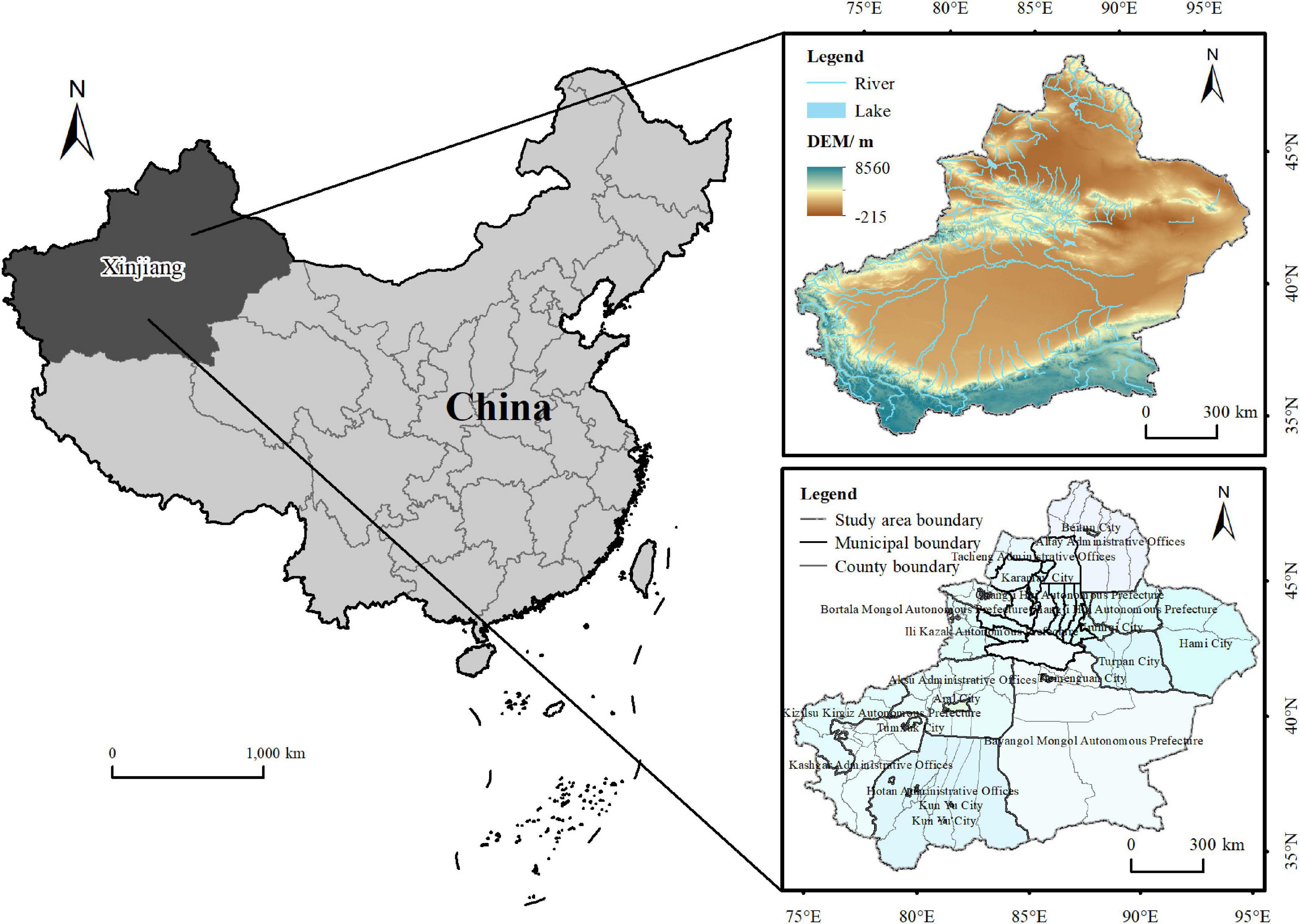
Figure 2. Study area overview map.
Data collection
The land use data (2000, 2005, 2010, 2015, 2018) was derived from 30 m resolution land use remote sensing monitoring data from the Resource and Environment Science and Data Center of the Chinese Academy of Sciences,1 which reclassifies the land use types into six primary categories: farmland, forest land, grassland, water, construction land, and unused land. The DEM data was derived from the Geospatial Data Cloud.2 Rainfall data was collected from the National Center for Atmospheric Sciences (NCAS).3 Socio-economic data were obtained from the Xinjiang Statistical Yearbook, China County Statistical Yearbook and Xinjiang Yearbook from 2000 to 2019. Due to the long-time span and the adjustment of administrative divisions, the data were unified into 2019 administrative divisions and municipal districts were combined in this study. Among them, sufficient data for Horgos City, Alashankou City, and 10 Corps cities were unavailable in and not included in this study, resulting in the finalization of 85 research units.
Research method
Farmland use pattern measurement methods
Combining relevant research results (Song et al., 2014; Niu et al., 2020) and the characteristics of Xinjiang’s farmland resources, this study measured the transformation of farmland use by two paths: spatial and functional patterns. Among them, spatial patterns included quantitative pattern, landscape pattern and operational pattern. Quantitative pattern is the quantitative characteristics of farmland. Landscape pattern refers to the landscape ecological characteristics of the farmland patches. The operational pattern is the concentration degree of farmers’ operating plots. This study adopted the ratio of farmland area to express the quantitative change of farmland to measure the quantitative pattern of farmland and adopted the patch density and farmland per agricultural worker to reflect the landscape pattern and operational pattern of farmland. Considering the long period of transformation of farmland use as well as the medium and macro scale of research, in the context of territorial spatial planning, the functional form of this study was measured by the widely recognized production function, ecological function, and living function (Zou et al., 2021). Production function is the most basic function, mainly referring to the material output capacity of farmland, including food crops and cash crops, etc. Therefore, this study used crop yield per unit area to measure the production function of farmland. Ecological function refers to the impact of farmland use on the ecological environment. The land average fertilizer application was used in this study to reflect the negative impact of farmland on the ecosystem, and the area of farmland to ecological land measured the positive impact of farmland on the ecosystem. The living function refers to the ability of farmland to provide a basic standard of living for people. Per capita food production was used to measure the food security capacity of farmland and the level of agricultural machinery to measure the employment security capacity of farmland.
To enable a more reasonable comparison of the characteristics of the spatial and functional transformation of farmland, the Farmland Spatial Pattern Index (FSP) and the Farmland Functional Pattern Index (FFP) are calculated through their respective indicator layers. Finally, this study used the hierarchical analysis method to construct an evaluation index system, the entropy weighting method to determine the weight of the index layer, and the expert scoring method to determine the weight of the target layer (Table 1). The comprehensive index weighting method was used for calculating the farmland use pattern index (FUP), the FSP and the farmland function pattern index to characterize the degree of farmland use transition, farmland use spatial transition, and farmland use functional transition, respectively. The formulae are:
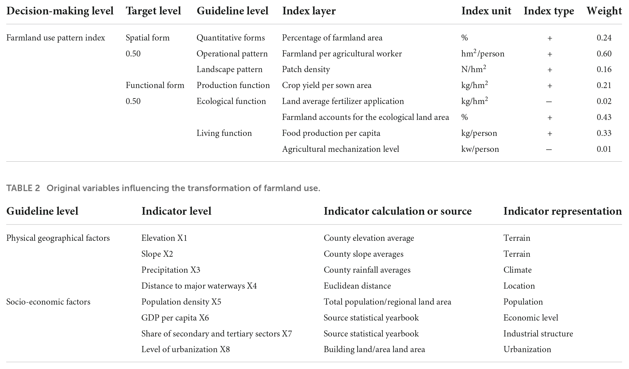
Table 1. Farmland use pattern indicator system.
where FUPi refers to the FUP of the county and city unit i, FSPi refers to the FSP of the county and city unit i, and FFPi refers to the farmland function pattern index of the county and city unit i. WFSP and WFFP refer to the weight values of the target layer, respectively. wij refers to the weight value of the jth indicator of area i calculated by the entropy weighting method. xij refers to the value of the jth indicator of county and city i xij refers to the value of the jth indicator of the county and city i after standardization of the extreme difference.
To determine the temporal trend of the transformation of farmland use in each county and city, the transformation of farmland use was classified into four types: continuous growth type (FUP2018>FUP2015>FUP2010>FUP2005>FUP2000), fluctuating growth type (FUP2018>FUP2000 and not of the first type), continuous decrease type (FUP2018<FUP2015<FUP2010<FUP2005<FUP2000) and fluctuating decrease type (FUP2018<FUP2000 and not of the third type) according to the change characteristics of the FUP.
Methodology for measuring the spatial patterns of farmland use
The Moran’I index, reflects the degree of similarity in the attribute values of spatially adjacent regional units and was used to examine the spatial clustering characteristics of the transformation of farmland use in Xinjiang. The formula is as follows.
Where n is the total number of observation units; xi and xj are the farmland morphological indices of the ith and jth study areas, respectively; is the mean value of the farmland use morphological indices of each area; Wij is the spatial weight matrix of study areas i and j. I is the Moran’I index, which takes values in the range of [−1,1], and when I > 0 it means that there is a positive correlation in the transformation of farmland use, a negative correlation in the transformation of farmland use, when I < 0, and no spatial autocorrelation in the transformation of farmland use when I = 0. The standardized statistic Z is usually used to test this.
The local spatial autocorrelation reveals the degree of correlation between a spatial unit and its neighboring unit attribute values, and is given by the formula:
where Ii is the Local Moran index. When Ii > 0, it is generally expressed as either high values surrounded by high values (HH) or low values surrounded by low values (LL); when Ii < 0, it is generally expressed as either low values surrounded by high values (LH), or high values surrounded by low values (HL).
Farmland use transition drivers and model selection
Eight indicators (Table 2), namely elevation, slope, precipitation, distance to major waterways, population density, per capita gross regional product, the share of secondary and tertiary industries, and the level of urbanization were selected from two aspects: natural and socio-economic. Geodetector have been applied in studies within the natural and social sciences as a favorable tool for driver and factor analysis, based on the assumption that if an independent variable is influenced by a significant influence on the dependent variable, then their spatial distribution has similarity. The method has no linearity assumption and is immune to covariates of the independent variables (Wang and Xu, 2017). In this study, factor detection and interaction detection were used to explore the explanatory power of factors and the interaction between factors, respectively.
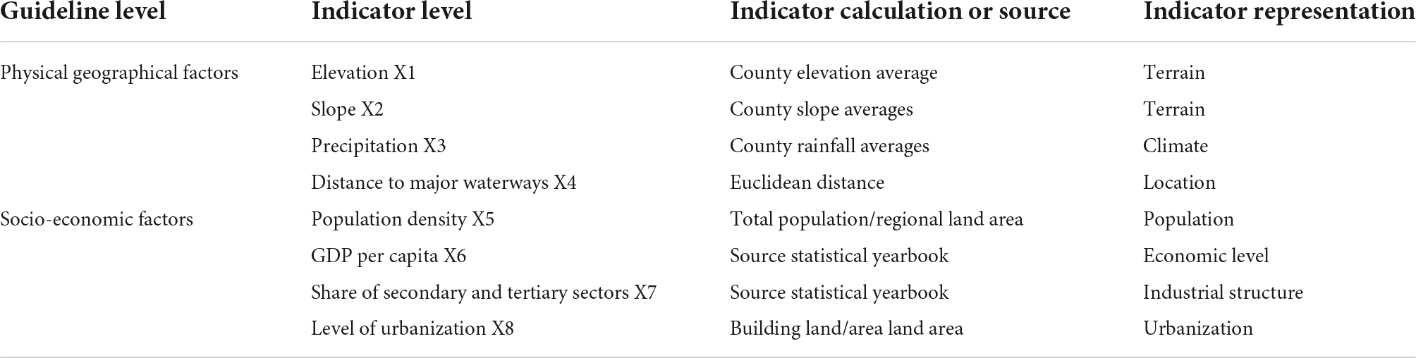
Table 2. Original variables influencing the transformation of farmland use.
Factor probing uses q-values to measure the extent to which factors explain the spatial divergence of the dependent variable, with the formula:
where q is the explanatory power of a factor on the spatial differentiation of farmland use transition, and its value range is [0, 1]. The larger the value of q is, the greater the influence of the factor on the spatial differentiation of farmland use transition; h = 1. L is the number of classifications of the influencing factor. n and Nh are the number of county units for the entire region and type h, respectively. σ2, are the variances of the farmland use pattern indices for the entire region and type h.
Interaction detection, detects the interactions between factors and is used to assess whether two factors acting together, increases or decreases the explanatory power of the dependent variable, or if the effects of these factors on the dependent variable are independent of each other (Wang and Xu, 2017). The relationship between the two factors can be classified into the following five types: Non-linear-weaken, when q(X1∩X2) < Min(q(X1),q(X2)); Uni-variable weaken, when Min(q(X1),q(X2)) < q(X1∩X2) < Max(q(X1),q(X2)); Bi-variable, when q(X1∩X2) > Max(q(X1),q(X2)); Independent, when q(X1∩X2) = q(X1) + q(X2); and Non-linear-enhance, when q(X1∩X2) > q(X1) + q(X2).
Traditional geodetectors generally use empirical knowledge to grade continuous variables, and the lack of quantitative discriminations can affect the explanatory power of the driving factors for farmland use transition. However, an optimal parameters-based geographical detector model allows for the selection of the result with the highest q-value for spatial data discretization (Song et al., 2020).
Results and analysis
Characteristics of farmland use transition
Spatial and temporal evolutionary characteristics of the transformation of farmland use
As shown in Table 3, the transformation trend of farmland use in Xinjiang mainly shows three types of trends, including continuous growth, fluctuating growth, and fluctuating decrease. Among them, most counties and cities show an increasing trend in the FUP, with the fluctuating growth type being the main pattern. This indicates that, overall, farmland use in Xinjiang is developing toward scale and multifunctionality, however, the process of change is not linear. The natural interruption point method was used to, respectively grade the FUP (Figure 3), the FSP (Figure 4) and the farmland function pattern index (Figure 5). There is clear evidence of spatial divergence of the transformation of farmland use. In general, Xinjiang’s farmland use morphology index shows an inverted “C” shape in the low value area around the high value area in the northwest. This is consistent with the physical geography of Xinjiang. Most of the inverted C-shaped areas have poor climatic and hydrological conditions, with the southern part being influenced by the Kunlun Mountains, situated at a high altitude and unsuitable for agricultural development. In terms of spatial units, areas with high values in the FUP are concentrated in the economic zone on the northern slopes of the Tianshan Mountains, the Yili Valley, Kashgar, and Hotan City. Among them, the Tianshan North Slope Economic Belt and the Yili Valley are the economic growth centers of Xinjiang, while the Kashgar Region and Hotan City are at the top of the socio-economic development level in southern Xinjiang. The low value areas are concentrated in the Bayangol Mongol Autonmous Prefecture and Hotan regions of southern Xinjiang and in Hami city in northern Xinjiang. The level of socio-economic development in these areas are inferior to those of other regions in Xinjiang. In addition, the spatially divergent characteristics of the spatial transformation of farmland use were generally the same as the spatially divergent characteristics of the functional transformation of farmland use. However, in some regions, the spatial transformation of farmland was not consistent with the functional transformation. For example, the functional transformation of farmland in Karamay City occurred faster than the spatial transformation. This is due to the rapid economic development in Karamay City and the faster functional manifestation of farmland.
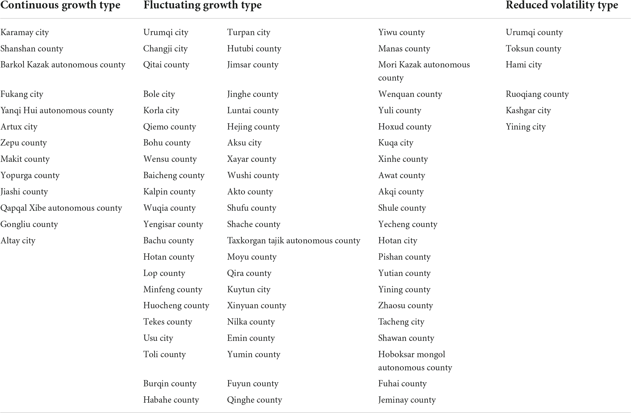
Table 3. Farmland use pattern indicator system.
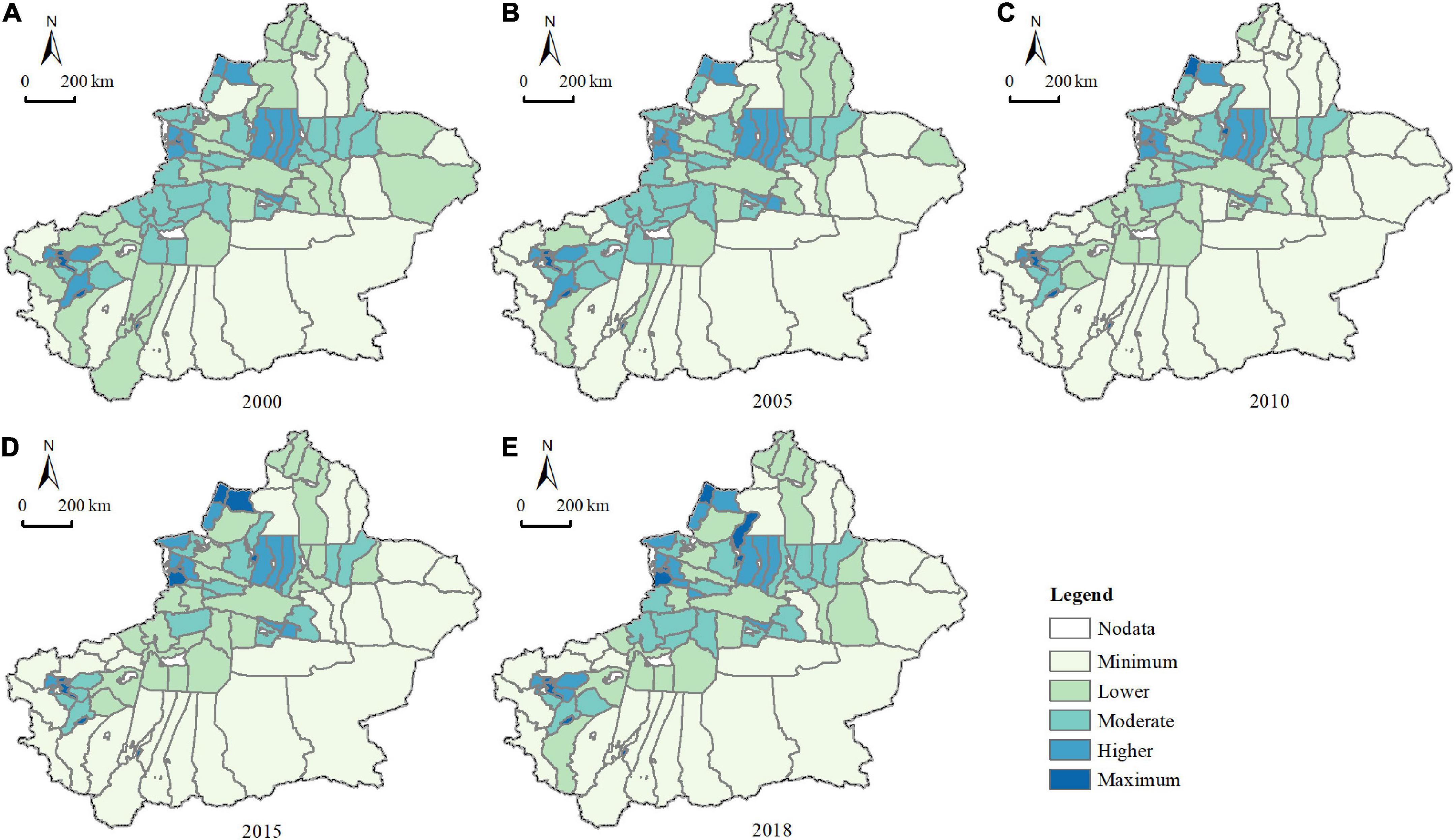
Figure 3. Spatial distribution of farmland use pattern index in (A) 2000, (B) 2005, (C) 2010, (D) 2015, and (E) 2018.
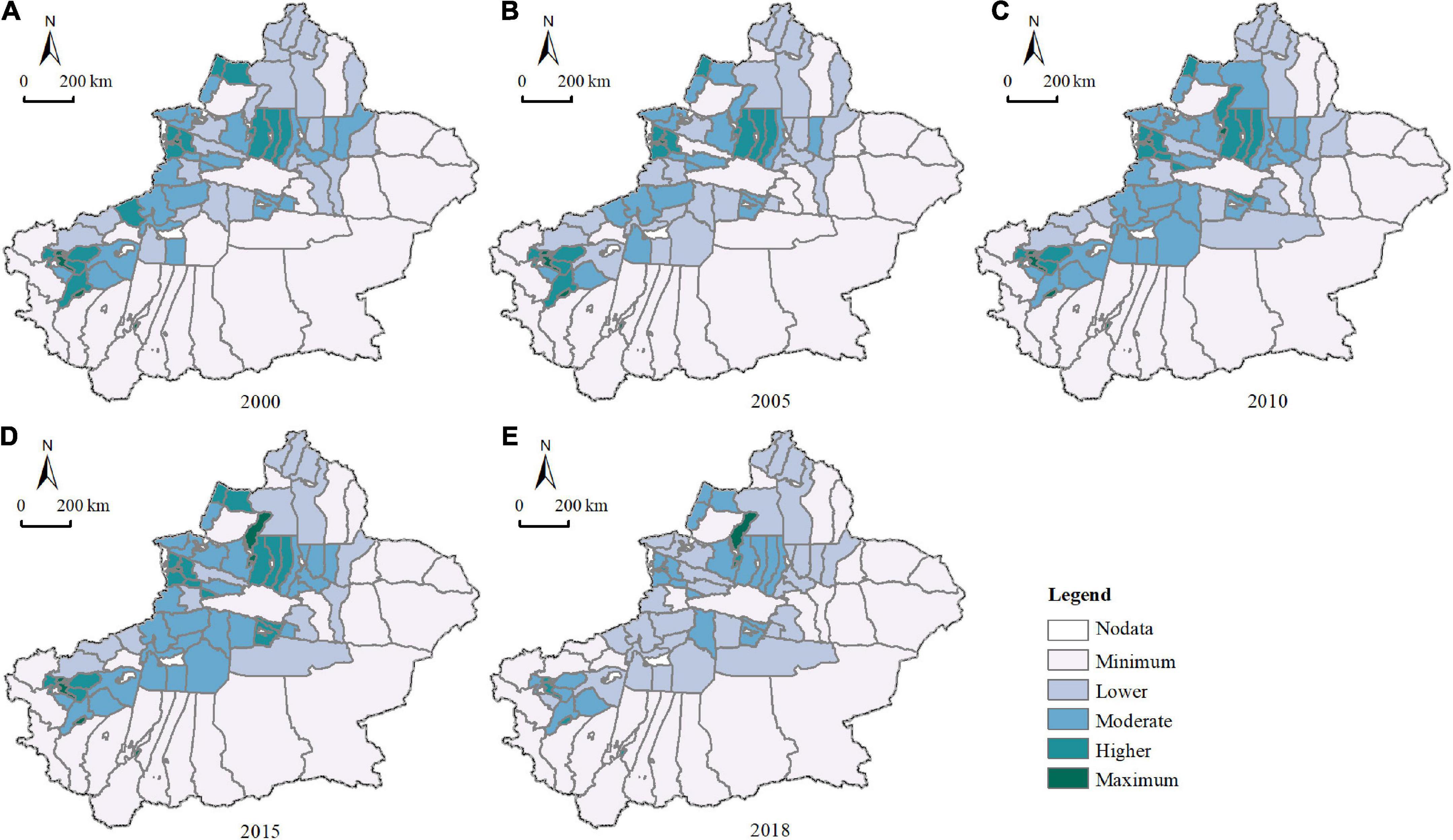
Figure 4. Spatial distribution of farmland spatial pattern index in (A) 2000, (B) 2005, (C) 2010, (D) 2015, and (E) 2018.
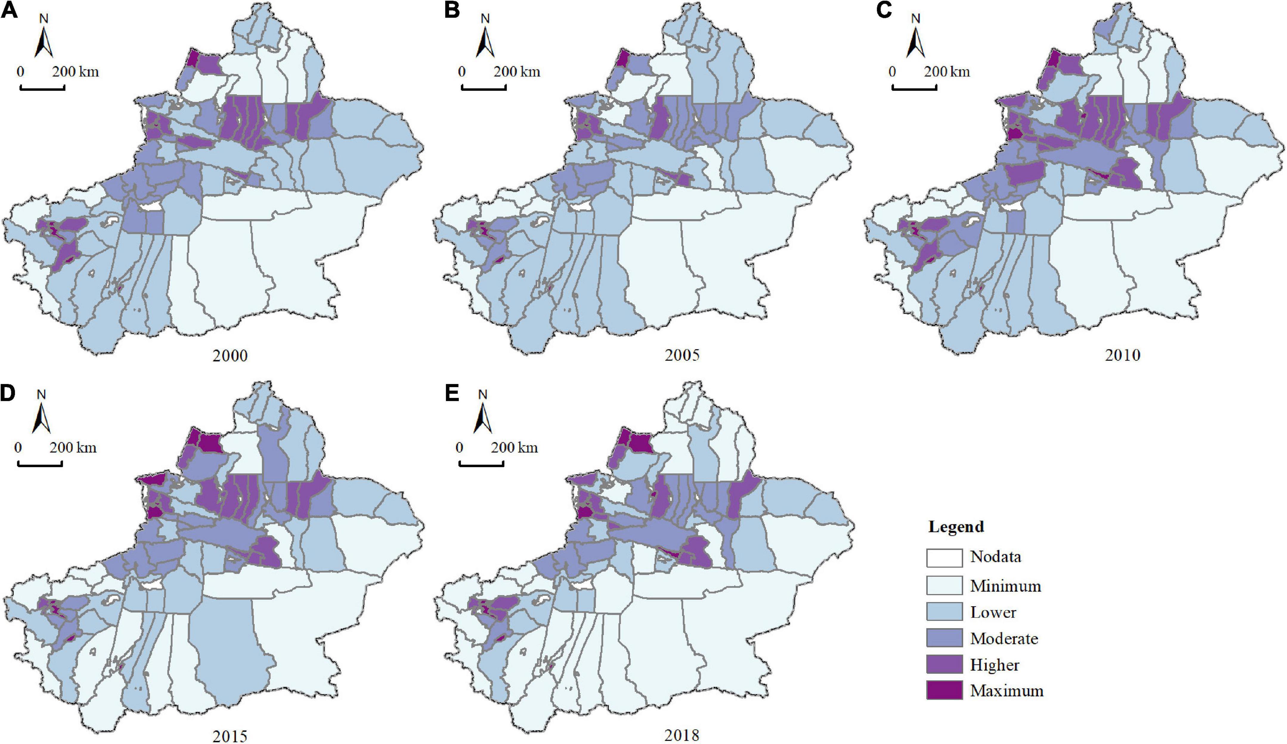
Figure 5. Spatial distribution of farmland function pattern index in (A) 2000, (B) 2005, (C) 2010, (D) 2015, and (E) 2018.
Spatial clustering characteristics of farmland use transition
In the past 20 years, agglomeration of farmland use transformation showed an irregular trend that first decreased, then increased and decreased again, but generally increased overall (Table 4). The agglomeration degree of spatial transformation of farmland use showed a decreasing, then increasing and decreasing, with an overall decreasing trend. The clustering characteristics of the functional transformation of farmland use showed a change characteristic that increased before decreasing, with an overall increasing trend. From Figure 6, the results of the local spatial autocorrelation show that there are more non-significant areas than significant areas in the transformation of farmland use, and the significant areas show an increasing trend. Simultaneously, the agglomeration areas are mainly present in the economic belt of the northern slope of Tianshan, Yili valley, and the Kashgar region. The results of the local spatial autocorrelation showed no change for 2000–2005. The HH areas were mainly distributed in Yining city, Yining county, Huocheng county, Chabchal Xibe autonomous county, Shache county, Zepu county, Shufan county, Kashgar city, and Shule county. The LH areas were mainly concentrated in Ucha county, Aktau county, and the HL zone mainly concentrated in Hetian city. For 2005–2010, five counties and cities, namely Manas county, Shawan county, Kuitun city, Usu city, and Tacheng city were added to the HH zone, of which all are located in the northern part of Xinjiang, and most situated on the northern slope of the Tianshan economic zone. Both Shache County and Zepu County transformed from HH zones to insignificant zones and are both located in South Xinjiang. For 2010–2018, the significant zones gradually decreased, indicating that the differences among counties and cities in Xinjiang gradually decreased. Meanwhile, the spatial transformation of farmland was inconsistent with the spatial clustering phenomenon of farmland function transformation. Among them, from 2000 to 2005, the spatial transformation of farmland HH areas were more than the functional transformation of farmland HH areas; these were mainly concentrated in Manas County, Shawan County, and Kuitun County. This indicates that the degree of change in the quantity and pattern of farmland in these areas, is more apparent than the change in function. Furthermore, during this period, Shawan County initiated the land transfer model through land exchanges to promote water-saving irrigation engineering measures, which increased the scale of farmland. In the subsequent period, several counties in the economic belt of the northern slope of Tianshan and the Yili River valley, had more functional transformation HH areas of farmland than spatial transformation HH areas of farmland. This was likely due to the construction of infrastructure, such as transportation, that promoted economic development in these regions, thus increasing the level of functional demand for farmland.
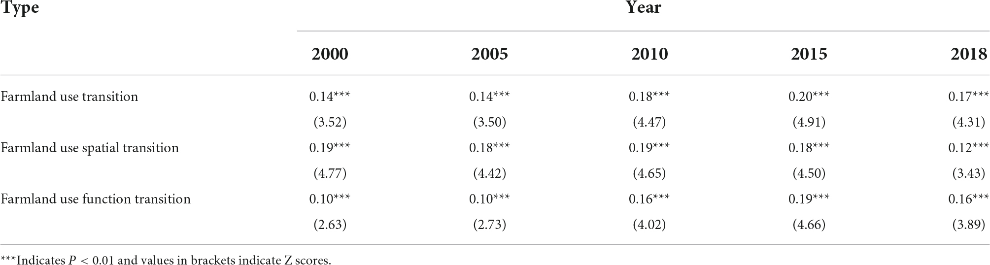
Table 4. The results of Global Moran’I.
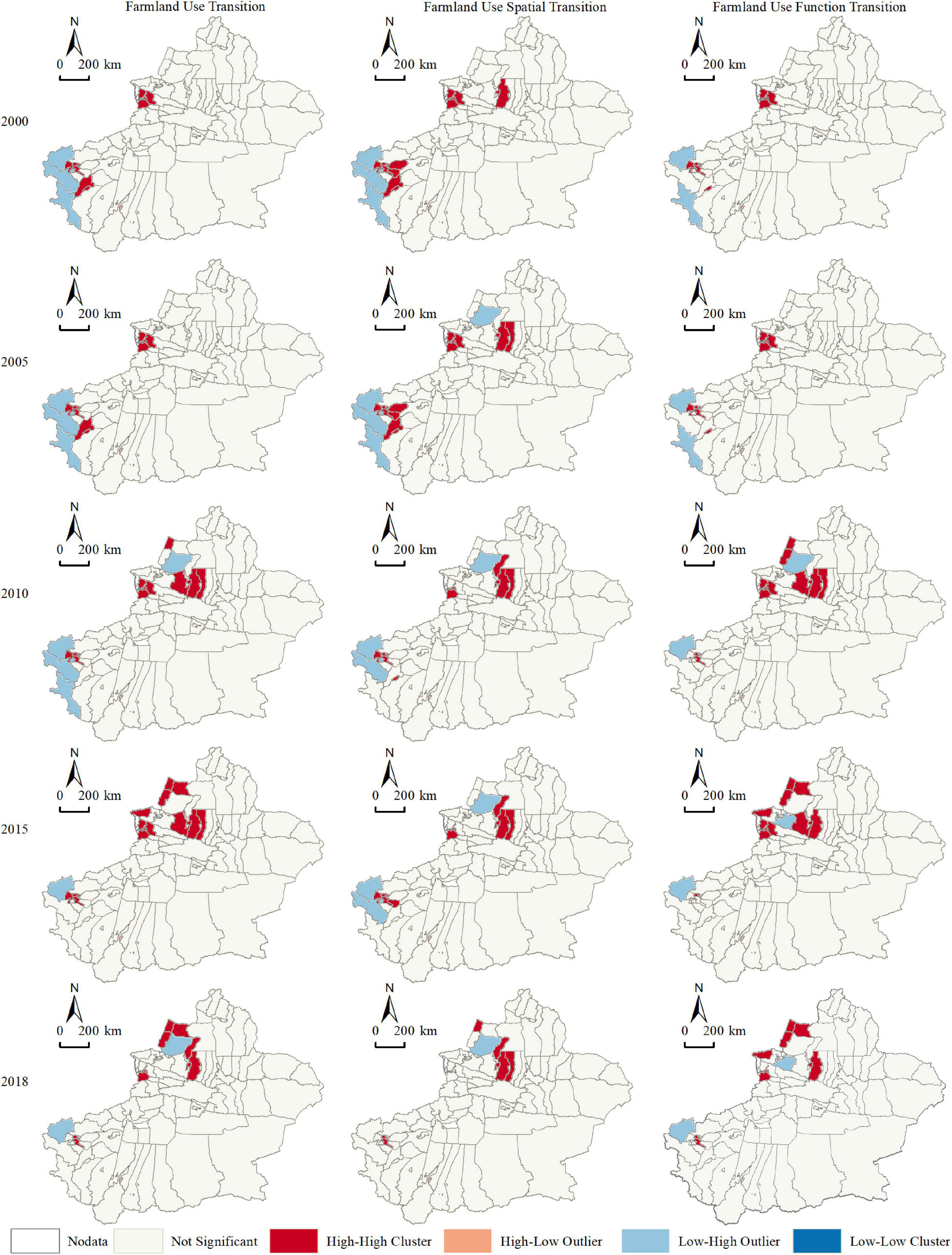
Figure 6. LISA map of farmland use transition.
Driving factors of farmland use transition
Factor detection results
The results of the factor detection (Figure 7) show that the explanatory power of the various factors varied from year to year. The period for 2000–2018, showed an increasing number of influencing factors that were significant for the transition of farmland use, however, the detection of gross regional product per capita (X6) was consistently insignificant. This suggests that economic level does not have a direct impact on farmland use transition. The q-value for distance from water systems (X4) was consistently high for 2000–2018, which indicated that water resources have a greater impact on agricultural development. However, the results for rainfall (X3) were only significant in 2005 and 2010, suggesting that rainfall had little impact on agricultural development in Xinjiang. This condition is due to the dry and rainy climate of the Northwestern arid zone. It is also noteworthy that the results for the topographic conditions elevation factor (X1) or slope factor (X2) and the population density factor (X5) were consistently significant, suggesting that topographic conditions and population were closely related to the transformation of farmland use. In addition, based on the results from 2010, an increasing number of socio-economic factors were significant. This may be related to the socio-economic development of Xinjiang attributed to the Central Symposium on Xinjiang Work held in 2010 and the injection of vitality into Xinjiang’s socio-economic development by the counterpart policies of 19 provinces and cities, which promoted the transformation of Xinjiang’s industrial structure and urbanization. Overall, there were more factors of significance for spatial transformation than for functional transformation. Among them, the proportion of secondary and tertiary industries (X7) was consistently insignificant for the results of functional transformation. This suggests that the change in industrial structure did not have a direct effect on the functional transformation of farmland.
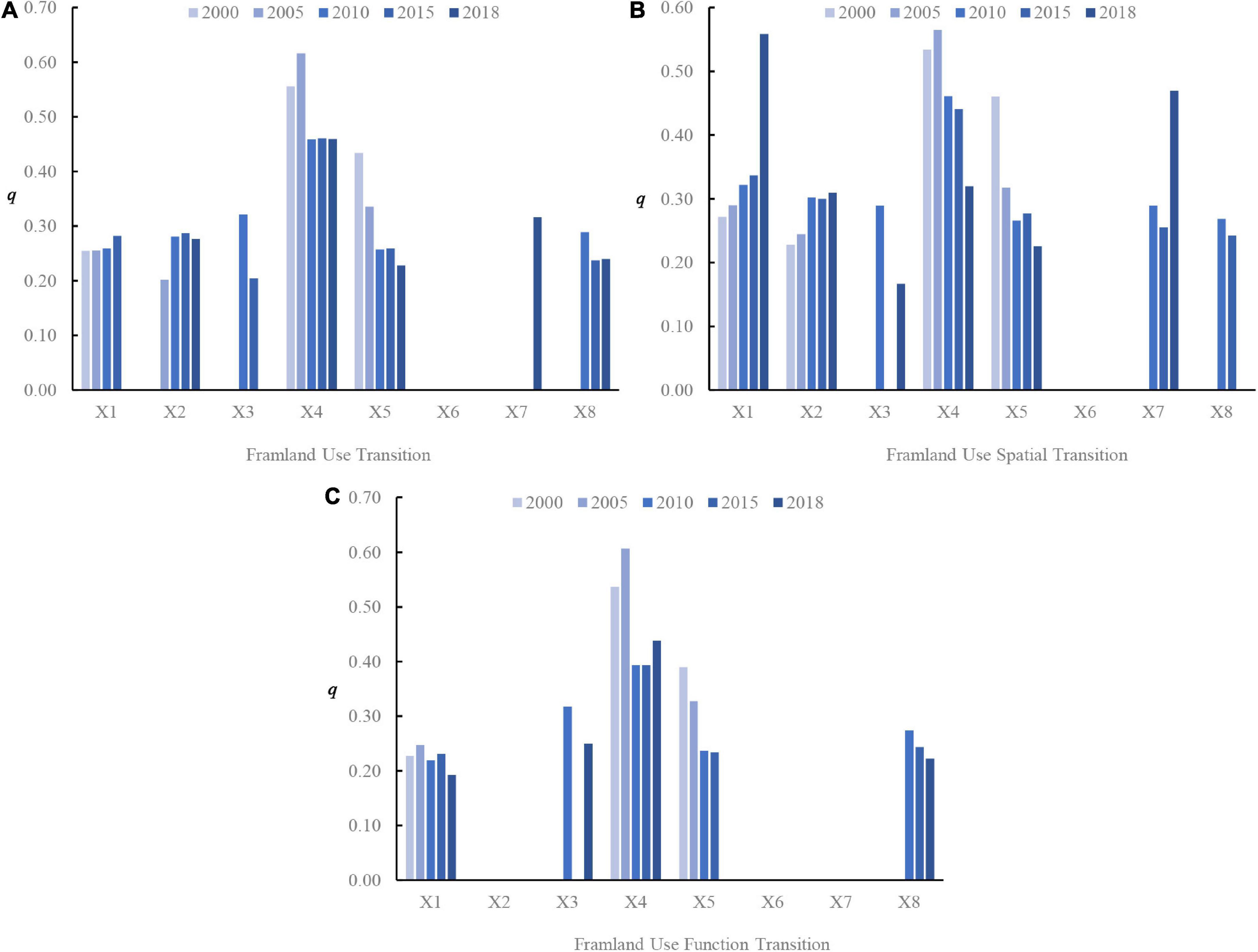
Figure 7. Factor detection results of (A) farmland use transition, (B) farmland use spatial transition, and (C) farmland use function transition.
Interaction detection results
The interaction detection results (Figure 8), showed several factors that did not act independently of each other and the interaction of the factors varied between periods. Simultaneously, there were interactions among different factors, such as within natural factors, socio-economic factors, or between different factors. All factor interactions generally showed non-linear increasing trends and a two-way increase, however, the interaction between the rainfall factor (X3) and the distance to water factor (X4) for 2000 and the interaction between the distance to water factor (X4) and the share of secondary and tertiary industries factor (X7) for 2010, showed a consistent non-linear decrease. Although the individual GDP per capita factor (X6) did not show significant results for the transformation of farmland use; its interaction with other factors showed a non-linear enhancement or a two-factor enhancement of the explanatory power. This suggests that the economic level contributes to the effect of other factors on farmland use transition. In addition, more interactions among the drivers of spatial transformation of farmland showed a weakening effect in 2018 than in other years, while more interactions among the drivers of spatial transformation of farmland showed a weakening effect in 2000 than in other years. This indicates that with socio-economic development, technological progress will gradually reduce the constraints of topographic conditions on the spatial and functional patterns of farmland.
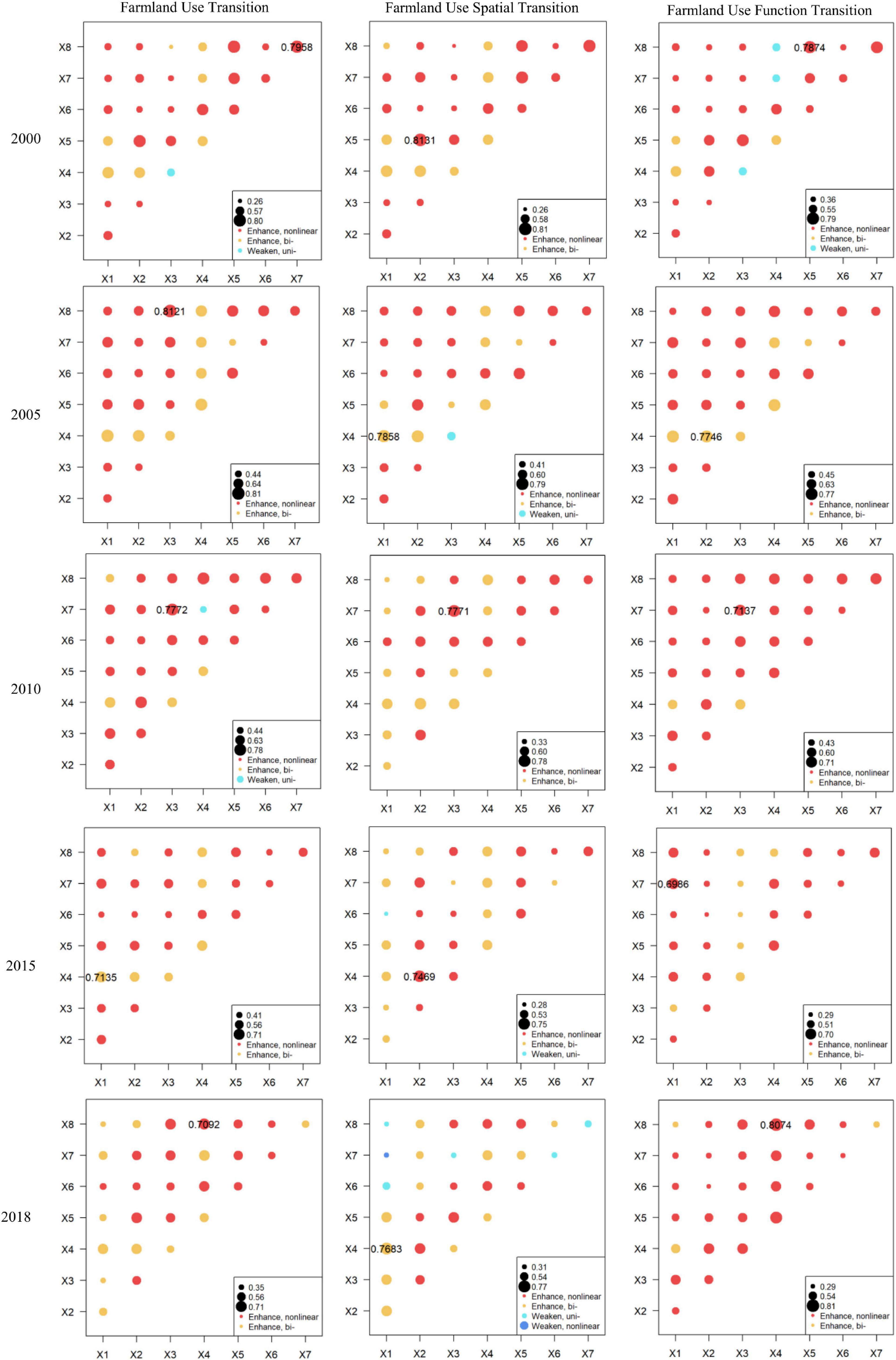
Figure 8. Interaction detection results.
Discussion
Impact of western development on the transformation of farmland use and policy implications
Two main mechanisms were responsible for the transformation of farmland use in Xinjiang, which resulted from China’s Western Development Policy. First, the construction of various farmland water conservancy infrastructures that has been undertaken since 2000, especially the promotion of water-saving irrigation projects, have contributed significantly to the enhancement of farmland development potential and increased the land reclamation rate. However, the benefits of these projects are limited, as the results of the influencing factors found that distance from the water system has been the factor with the greatest explanatory power for the transformation of farmland use. Second, in 2005, the construction of a new socialist countryside was launched to guide non-farm employment and promote agricultural industrialization. The increase in non-farm employment has to some extent, laid the foundation for large-scale agriculture. Since 2010, Xinjiang has been vigorously promoting the modernization of agriculture. In 2013, the primary mode of agricultural production and operation, mainly large professional households and farmers’ professional cooperatives, developed rapidly. The emergence of land share cooperatives led to the orderly transfer of land, changing the landscape pattern of farmland and improving farmland efficiency. In 2016, farmland film pollution control was implemented in Xinjiang, and the ecological function of farmland recovered. Moreover, by curbing pollution, structural reform of agricultural supply, agricultural leisure, and tourism development was promoted, this improved the cultural function of the farmland landscape. The results of the analysis of influencing factors found that the economic level had no direct influence on the transformation of farmland use in Xinjiang, however, it did promote the influence of other factors on the transformation of farmland use. This is due to the fact that the development of the economic level will promote the increase of multifunctional demand of farmland, which will promote the transformation of farmland use. This is an important pathway of farmland use transformation.
Summarizing the experience since the implementation of the Western Development Policy in China, the transformation of the spatial pattern of farmland in Xinjiang has increased and its productive functions improved through the construction of water-saving irrigation and other farmland water conservancy projects. The exploration of land transfer has improved the fragmentation and area of farmland, thus significantly increasing its social and ecological value and generating multiple external benefits (Yan et al., 2021). Since 2015, the advancement of structural reform in agricultural supply, has promoted the rapid development of leisure and tourism agriculture; in addition, the cultural function of farmland landscape has furthered the landscape pattern transformation. Furthermore, the treatment of polluted mulch on farmland has reduced the deterioration of ecological functions. In conclusion, land engineering is directly changing the spatial pattern of farmland in Xinjiang, but its role is limited; while land policy has promoted the functional transformation of farmland in Xinjiang, it is still primarily at the stage of production function.
According to the theoretical evolutionary characteristics of farmland use transformation, farmland will develop toward multifunctionalities. However, despite the influence of several policies and land projects since the western development, the functional transformation of farmland in Xinjiang remains largely engaged in production only. To achieve the goals of rural revitalization and ecological protection in the western region, regions should adjust their farmland use management policies according to the county-level use patterns to promote resource use and sustainable development and base it on the driving mechanisms of farmland use transformation. The “New Western Development” requires the formation of a modern industrial system, the integration of rural industries and the optimization of rural employment structure. It is recommended to further reduce the “white pollution” of farmland mulch, improve the ecological cultural functions of farmland by means of leisure and tourism agriculture, by considering the economic level and cultural characteristics of different regions to promote the transformation of the landscape pattern of farmland.
The zoning can be optimized according to the characteristics of the spatial and functional patterns of farmland in the region. The spatial pattern index of farmland use and the function pattern index of farmland use, which are graded as “Moderate” above, are regarded as high value areas, and vice versa, as low value areas. The area where the low value of the function pattern of farmland and the low value of the spatial pattern of farmland overlap is the priority area for spatial transformation, accounting for 72.94%. This area should focus on spatial transformation. It is suggested that it can strengthen the construction of high-standard farmland to improve the level of scale and quality of farmland. The area where the low value of the function pattern of farmland and the high value of the spatial pattern of farmland overlap is a priority area for functional transformation, with only the city of Karamay. Its level of agricultural mechanization is high, but the various functions of farmland have not been revealed. It is recommended that organic fertilizers be applied instead of chemical fertilizers, biodegradable films be used and tourism and agricultural infrastructure be strengthened to promote the multi-functionality of farmland. The area where the high value of the function pattern of farmland and the low value of the spatial pattern of farmland overlap is an incentive zone for spatial transformation. The productive, ecological and living functions of farmland in this zone are fully utilized, but their quantity and pattern do not match them. The occupation of farmland should be avoided and, at the same time, the landscape and management pattern should be optimized. The area where the high value of the functional form of farmland and the high value of the spatial form of farmland overlap is an incentive zone for functional transformation. The spatial form of farmland in this zone matches the functional form, and the multifunctional value of farmland is also fully utilized. It is recommended that this zone should pay more attention to the changing needs of the region when managing the use of farmland, so as to stimulate its functional transformation.
Limitations and future work
The sustainable use of farmland in China is of great significance to sustainable human development and national stability (Ye et al., 2020). This study analyzed the spatial and temporal evolution characteristics of the transformation of farmland use in Xinjiang counties and its driving mechanisms. The results of the study can provide decision support for the management of farmland use at the medium and macro levels. However, the following shortcomings were observed in this study: (1) There is scope to improve the establishment of the indicator system. If more data could be obtained, the system of indicators of farmland use patterns and the selection of drivers could be more systematic. For example, a number of agro-tourism parks could be adopted to characterize the life functions of farmland in terms of landscape culture. The policy factors affecting the transformation of farmland use can be measured by selecting indicators such as agricultural-related financial expenditure. (2) This study only examined the transformation of farmland use, in terms of spatial and functional patterns, which is a limited guide to the manage farmland use. In contrast, more implicit forms of farmland conditions, such as quality and management methods are important for guiding farmland use management. Simultaneously, this study can only make policy recommendations from a medium to macro perspective, as the spatial unit directly related to the transformation of farmland use is the village area. Therefore, more implicit forms and micro-scale research are required. (3) The transformation of farmland use is influenced by the entire country and even the global scale, especially for Xinjiang, where the construction of the Silk Road Economic Belt core zone has promoted the level of globalization and influenced the socio-economic development of Xinjiang, therefore, a future research direction is to investigate the driving mechanism at multiple scales.
Conclusion
The land use structure of Xinjiang since the implementation of the Western Development Policy, is closely related to social and economic development in the region, and there are obvious regional differences. In this study, we constructed a theoretical framework for farmland use transition and established farmland use pattern indicators from the perspectives of farmland spatial pattern and functional pattern, to measure the characteristics of farmland use transition in Xinjiang. Additionally, we explored the driving factors of the transformation of farmland use through an optimal geographic probe based on parameters. The results of the study provided evidence of the transformation of farmland use toward large scale and multifunctionality, which is largely coincided with the degree of change in socio-economic development. The transformation characteristics were mainly of fluctuating growth, with several counties and cities showing a trend of continuous growth or fluctuating decrease. The spatial transformation of farmland and the functional transformation were generally the same, however, for some counties and cities with rapid socio-economic development, the functional transformation was faster than the spatial transformation. In addition, the transformation of farmland use showed spatial agglomeration that was mainly concentrated in the northern slope of Tianshan Mountain, the Yili River Valley, and Kashgar region; the degree of agglomeration showed an increasing trend. The degree of clustering of farmland functional transformation also showed an increasing trend, but the spatial transformation of farmland showed a decreasing trend. The transformation of farmland use in Xinjiang was influenced by natural and socio-economic factors and policies and the influence of different factors and their interactions varied in different periods. Distance to water systems is the most important natural geographical factor influencing the transition of farmland use, but its influence is decreasing. Economic level has no direct influence on the transition of farmland use in Xinjiang, but can contribute to the influence of other factors on the transition of farmland use. Although, western development has greatly promoted the transformation of farmland use in Xinjiang, but it has mainly contributed to the spatial transformation, and the transformation of farmland function is still primarily at production levels. In the future, it is suggested that the new western development period promotes the multifunctional use of farmland. Starting from the demand side of farmland, the spatial transformation of farmland is promoted by promoting the multifunctional play of farmland.
Data availability statement
The original contributions presented in this study are included in the article/Supplementary material, further inquiries can be directed to the corresponding author.
Author contributions
XL: conceptualization, methodology, software, writing—original draft preparation, and visualization. YC: validation, formal analysis, project administration, and funding acquisition. LX: supervision, investigation, and resources. PL and RZ: data curation. YC and PL: writing—review and editing. All authors contributed to the article and approved the submitted version.
Funding
This work was supported by the National Natural Science Foundation of China (No. 31760151) and the Shihezi University Young Innovative Cultivating Talent Program Project (No. CXPYSK201905).
Conflict of interest
The authors declare that the research was conducted in the absence of any commercial or financial relationships that could be construed as a potential conflict of interest.
Publisher’s note
All claims expressed in this article are solely those of the authors and do not necessarily represent those of their affiliated organizations, or those of the publisher, the editors and the reviewers. Any product that may be evaluated in this article, or claim that may be made by its manufacturer, is not guaranteed or endorsed by the publisher.
Supplementary material
The Supplementary Material for this article can be found online at: https://www.frontiersin.org/articles/10.3389/fevo.2022.942065/full#supplementary-material
Footnotes
References
Bahtebay, J., Zhang, F., Ariken, M., Chan, N. W., and Tan, M. L. (2021). Evaluation of the coordinated development of urbanization-resources-environment from the incremental perspective of Xinjiang, China. J. Clean. Prod. 325:129309. doi: 10.1016/j.jclepro.2021.129309
Barbier, E. B., Burgess, J. C., and Grainger, A. (2010). The forest transition: Towards a more comprehensive theoretical framework. Land Use Pol. 27, 98–107. doi: 10.1016/j.landusepol.2009.02.001
Barbier, E. B., Delacote, P., and Wolfersberger, J. (2017). The economic analysis of the forest transition: A review. J. For. Econ. 27, 10–17. doi: 10.1016/j.jfe.2017.02.003
Bertoni, D., Aletti, G., Ferrandi, G., Micheletti, A., Cavicchioli, D., and Pretolani, R. (2018). Farmland Use Transitions After the CAP Greening: A Preliminary Analysis Using Markov Chains Approach. Land Use Pol. 79, 789–800. doi: 10.1016/j.landusepol.2018.09.012
Bren d’Amour, C., Reitsma, F., Baiocchi, G., Barthel, S., Güneralp, B., Erb, K. H., et al. (2017). Future urban land expansion and implications for global croplands. Proc. Natl. Acad. Sci. U.S.A. 114, 8939–8944. doi: 10.1073/pnas.1606036114
Bucala-Hrabia, A. (2017). Long-term impact of socio-economic changes on agricultural land use in the Polish Carpathians. Land Use Pol. 64, 391–404. doi: 10.1016/j.landusepol.2017.03.013
Cai, T. Y., Zhang, X. H., Xia, F. Q., Zhang, Z. P., Yin, J. J., and Wu, S. Q. (2021). The Process-Mode-Driving Force of Cropland Expansion in Arid Regions of China Based on the Land Use Remote Sensing Monitoring Data. Remote Sens. 13:2949. doi: 10.3390/rs13152949
Chen, K., Long, H., Liao, L., Tu, S., and Li, T. (2020). Land use transitions and urban-rural integrated development: Theoretical framework and China’s evidence. Land Use Pol. 92:104465. doi: 10.1016/j.landusepol.2020.104465
Du, G., Guo, K., and Yu, F. (2021). Suggestions on the transition and regulation of farmland utilization function in Heilongjiang Province. Reas. Agric. Mod. 42, 589–599. doi: 10.13872/j.1000-0275.2021.0080
Francis, C. A., Hansen, T. E., Fox, A. A., Hesje, P. J., Nelson, H. E., Lawseth, A. E., et al. (2012). Farmland conversion to non-agricultural uses in the US and Canada: Current impacts and concerns for the future. Int. J. Agric. Sustain. 10, 8–24. doi: 10.1080/14735903.2012.649588
Fu, H., Liu, Y., Sun, H., and Zhou, G. (2020). Spatiotemporal characteristics and dynamic mechanism of cultivated land use transition in the Beijing-Tianjin-Hebei region. Prog. Geogr. 39, 1985–1998.
Ge, D., Long, H., Zhang, Y., Ma, L., and Li, T. (2018b). Farmland transition and its influences on grain production in China. Land Use Pol. 70, 94–105. doi: 10.1016/j.landusepol.2017.10.010
Ge, D., Long, H., and Ren, Y. (2018a). The pattern and mechanism of farmland transition in China from the perspective of per capita farmland area. Resour. Sci. 40, 273–283. doi: 10.18402/resci.2018.02.05
Ge, D., Wang, Z., Tu, S., Long, H., Yan, H., Sun, D., et al. (2019). Coupling analysis of greenhouse-led farmland transition and rural transformation development in China’s traditional farming area: A case of Qingzhou City. Land Use Pol. 86, 113–125. doi: 10.1016/j.landusepol.2019.05.002
Grainger, A. (1995). National Land-Use Morphology - Patterns And Possibilities. Geography 80, 235–245.
He, K., Wu, S., Yang, Y., Wang, D., Zhang, S., and Yin, N. (2018). Dynamic changes of land use and oasis in Xinjiang in the last 40 years. Arid Land Geogr. 41, 1333–1340.
Hu, Q. L., Yang, Y. H., Han, S. M., and Wang, J. S. (2019). Degradation of agricultural drainage water quantity and quality due to farmland expansion and water-saving operations in arid basins. Agric. Water Manag. 213, 185–192. doi: 10.1016/j.agwat.2018.10.019
Jia, J., Ma, G., Qin, C., and Wang, L. (2020). Place-based policies, state-led industrialisation, and regional development: Evidence from China’s Great Western Development Programme. Eur. Econ. Rev. 123:103398. doi: 10.1016/j.euroecorev.2020.103398
Jiang, G., Wang, M., Qu, Y., Zhou, D., and Ma, W. (2020). Towards cultivated land multifunction assessment in China: Applying the “influencing factors-functions-products-demands” integrated framework. Land Use Pol. 99:104982. doi: 10.1016/j.landusepol.2020.104982
Lambin, E. F., and Meyfroidt, P. (2010). Land use transitions: Socio-ecological feedback versus socio-economic change. Land Use Pol. 27, 108–118. doi: 10.1016/j.landusepol.2009.09.003
Liao, L., Long, H., Gao, X., and Ma, E. (2019). Effects of land use transitions and rural aging on agricultural production in China’s farming area: A perspective from changing labor employing quantity in the planting industry. Land Use Pol. 88:104152. doi: 10.1016/j.landusepol.2019.104152
Liao, N., Gu, X. C., Wang, Y. J., Xu, H. L., and Fan, Z. L. (2021). Analysis of Ecological and Economic Benefits of Rural Land Integration in the Manas River Basin Oasis. Land 10:451. doi: 10.3390/land10050451
Liu, Y., and Zhou, Y. (2021). Reflections on China’s food security and land use policy under rapid urbanization. Land Use Pol. 109:105699. doi: 10.1016/j.landusepol.2021.105699
Long, H., Ge, D., and Wang, J. (2019). Progress and prospects of the coupling research on land use transitions and rural transformation development. Acta Geogr. Sin. 74, 2547–2559. doi: 10.11821/dlxb201912009
Long, H., Zhang, Y., Ma, L., and Tu, S. (2021b). Land Use Transitions: Progress, Challenges and Prospects. Land 10:903. doi: 10.3390/land10090903
Long, H., Kong, X., Hu, S., and Li, Y. (2021a). Land Use Transitions under Rapid Urbanization: A Perspective from Developing China. Land 10:935. doi: 10.3390/land10090935
Long, H., Qu, Y., Tu, S., Zhang, Y., and Jiang, Y. (2020). Development of land use transitions research in China. J. Geogr. Sci. 30, 1195–1214. doi: 10.1007/s11442-020-1777-9
Long, H., and Tu, S. (2018). Land Use Transition and Rural Vitalization. China Land Sci. 32, 1–6. doi: 10.11994/zgtdkx.20180629.144201
Long, H. L., and Qu, Y. (2018). Land use transitions and land management: A mutual feedback perspective. Land Use Pol. 74, 111–120. doi: 10.1016/j.landusepol.2017.03.021
Lu, X., Tang, Y., Yi, J., and Jiang, X. (2019). Study on the Impact of Cultivated Land Use Transition on Agricultural Economic Growth based on Spatial Econometric Model. China Land Sci. 33, 53–61. doi: 10.11994/zgtdkx.20190603.091533
Lyu, L., Gao, Z., Long, H., Wang, X., and Fan, Y. (2021). Farmland Use Transition in a Typical Farming Area: The Case of Sihong County in the Huang-Huai-Hai Plain of China. Land 10:347. doi: 10.3390/land10040347
Mi, Q., Li, X., and Gao, J. (2020). How to improve the welfare of smallholders through agricultural production outsourcing: Evidence from cotton farmers in Xinjiang, Northwest China. J. Clean. Prod. 256:120636. doi: 10.1016/j.jclepro.2020.120636
Niu, S., Fang, B., Cui, C., and Huang, S. (2020). The spatial-temporal pattern and path of cultivated land use transition from the perspective of rural revitalization:Taking Huaihai Economic Zone as an example. J. Nat. Resour. 35, 1908–1925. doi: 10.31497/zrzyxb.20200812
Paul, V., and McKenzie, F. H. (2013). Peri-urban farmland conservation and development of alternative food networks: Insights from a case-study area in metropolitan Barcelona (Catalonia. Spain). Land Use Pol. 30, 94–105. doi: 10.1016/j.landusepol.2012.02.009
Qu, Y., and Long, H. (2018). A framework of multi-disciplinary comprehensive research on recessive farmland transition in China. Acta Geogr. Sin. 73, 1226–1241. doi: 10.11821/dlxb201807004
Rudel, T. K., Schneider, L., and Uriarte, M. (2010). Forest transitions: An introduction. Land Use Pol. 27, 95–97. doi: 10.1016/j.landusepol.2009.09.021
Sheng, Y., Liu, W. Z., Xu, H. L., and Gao, X. C. (2021). The Spatial Distribution Characteristics of the Cultivated Land Quality in the Diluvial Fan Terrain of the Arid Region: A Case Study of Jimsar County, Xinjiang, China. Land 10:896. doi: 10.3390/land10090896
SHI, Y., Lü, X., Huang, X., and Yu, M. (2017). Arable Land Use Transitions and Its Response of Ecosystem Services Value Change in Jiangsu Coastal Areas. J. Nat. Resour. 32, 961–976. doi: 10.11849/zrzyxb.20160587
Singh, M. P., Bhojvaid, P. P., De Jong, W., Ashraf, J., and Reddy, S. R. (2017). Forest transition and socio-economic development in India and their implications for forest transition theory. For. Pol. Econ. 76, 65–71. doi: 10.1016/j.forpol.2015.10.013
Song, X., Wu, Z., and Ouyang, Z. (2014). Route of cultivated land transition research. Geogr. Res. 33, 403–413. doi: 10.11821/dlyj201403001
Song, Y. Z., Wang, J. F., Ge, Y., and Xu, C. D. (2020). An optimal parameters-based geographical detector model enhances geographic characteristics of explanatory variables for spatial heterogeneity analysis: Cases with different types of spatial data. GISci. Remote Sens. 57, 593–610. doi: 10.1080/15481603.2020.1760434
Wang, J., and Xu, C. (2017). Geodetector: Principle and prospective. Acta Geogr. Sin. 72, 116–134. doi: 10.11821/dlxb201701010
Wang, Y. J., Liu, G. Y., and Liu, X. H. (2022). Spatiotemporal Coupling and Driving Factors of Farmland Transfer and Labor Transfer Based on Big Data: The Case of Xinjiang, China. Wirel. Commun. Mob. Comput. 2022:7604448. doi: 10.1155/2022/7604448
Xiong, Y. K., Zhang, Q. L., Chen, X., Bao, A. M., Zhang, J. Y., and Wang, Y. J. (2019). Large Scale Agricultural Plastic Mulch Detecting and Monitoring with Multi-Source Remote Sensing Data: A Case Study in Xinjiang, China. Remote Sens. 11:2088. doi: 10.3390/rs11182088
Xu, Y. Q., Mcnamara, P., Wu, Y. F., and Dong, Y. (2013). An econometric analysis of changes in arable land utilization using multinomial logit model in Pinggu district, Beijing, China. J. Environ. Manag. 128, 324–334. doi: 10.1016/j.jenvman.2013.05.020
Yan, X., Wang, Y., Liao, N., Xu, H., and Fan, Z. (2021). Assessment of Value Changes and Spatial Differences in Land Use Based on an Empirical Survey in the Manas River Basin. Land 10:961. doi: 10.3390/land10090961
Yang, F. C., and Liu, G. Y. (2022). Research on Spillover Effect of Urbanization on Rural Land Transfer Based on the SDM Model of Intelligent Computing. Mob. Inf. Syst. 2022:9921309. doi: 10.1155/2022/9921309
Yao, J., Zhao, Y., Chen, Y., Yu, X., and Zhang, R. (2018). Multi-scale assessments of droughts: A case study in Xinjiang, China. Sci. Total Environ. 630, 444–452. doi: 10.1016/j.scitotenv.2018.02.200
Ye, S., Song, C., Shen, S., Gao, P., and Zhu, D. (2020). Spatial pattern of arable land-use intensity in China. Land Use Pol. 99:104845. doi: 10.1016/j.landusepol.2020.104845
Zhang, C., Zhou, B., and Wang, Q. W. (2019). Effect of China’s western development strategy on carbon intensity. J. Clean. Prod. 215, 1170–1179. doi: 10.1016/j.jclepro.2019.01.136
Zhang, H., and Li, D. (2021). Concept and classification of unstable farmland in arid area of Northwest China: A case study of Changji Prefecture, Xinjiang. Geogr. Res. 40, 597–612. doi: 10.11821/dlyj020200846
Zhang, R. Q., Li, P. H., Xu, L. P., Zhong, S., and Wei, H. (2022). An integrated accounting system of quantity, quality and value for assessing cultivated land resource assets: A case study in Xinjiang, China. Glob. Ecol. Conserv. 36:e02115. doi: 10.1016/j.gecco.2022.e02115
Zhou, X. P., Li, X. T., Song, W., Kong, X. B., and Lu, X. (2021). Farmland Transitions in China: An Advocacy Coalition Approach. Land 10:122. doi: 10.3390/land10020122
Zhou, Y., Li, X., and Liu, Y. (2021). Cultivated land protection and rational use in China. Land Use Pol. 106:105454. doi: 10.1016/j.landusepol.2021.105454
Zhuo, C., and Deng, F. (2020). How does China’s Western Development Strategy affect regional green economic efficiency? Sci. Total Environ. 707:135939. doi: 10.1016/j.scitotenv.2019.135939
Keywords: land use transition, farmland function, driving mechanism, China’s Western Development Policy, Xinjiang
Citation: Li X, Chen Y, Xu L, Li P and Zhang R (2022) Transformation of farmland use and driving mechanism in Xinjiang since China’s Western Development Policy. Front. Ecol. Evol. 10:942065. doi: 10.3389/fevo.2022.942065
Received: 12 May 2022; Accepted: 05 September 2022;
Published: 03 October 2022.
Edited by:
Xiaobin Jin, Nanjing University, ChinaReviewed by:
Yongjun Yang, China University of Mining and Technology, ChinaTan Shukui, Huazhong University of Science and Technology, China
Copyright © 2022 Li, Chen, Xu, Li and Zhang. This is an open-access article distributed under the terms of the Creative Commons Attribution License (CC BY). The use, distribution or reproduction in other forums is permitted, provided the original author(s) and the copyright owner(s) are credited and that the original publication in this journal is cited, in accordance with accepted academic practice. No use, distribution or reproduction is permitted which does not comply with these terms.
*Correspondence: Yuejiao Chen, Y2hlbnl1ZWppYW9Ac2h6dS5lZHUuY24=