 Krish Seetah
 Stefania Manfio
 Andrea Balbo
 R. Helen Farr
 F. B. Vincent Florens
- 1Department of Anthropology and Woods Institute for the Environment, Stanford University, Stanford, CA, United States
- 2Department of Anthropology, Stanford University, Stanford, CA, United States
- 3Laboratory of Prehistoric Archeaology and Anthropology, Université de Genève, Geneva, Switzerland
- 4Planthro Inc., New York, NY, United States
- 5Archaeology, University of Southampton, Southampton, United Kingdom
- 6Tropical Island Biodiversity, Ecology and Conservation Pole of Research, Faculty of Science, University of Mauritius, Réduit, Mauritius
The colonization of Mauritius exemplifies the role played by humans in altering the ecosystems of remote oceanic islands. This paper focuses on how we study those islands first colonized under the global mantle of colonialism. Here we aim to provide a framework for historical ecological investigations to disentangle the processes, impacts, and outcomes of colonization during colonialism, considering local, regional, and global drivers. The paper provides a review of existing literature, outlines a proposed research program encompassing paleoecology, paleoclimatology, archeology, and history, and offers details of potential research sites. We present “historical ecology” as a framework to aid future work, and argue that a refined understanding of the impact of human colonization can help create a nuanced chronology of environmental degradation that typifies Mauritius. Such detailed assessment is necessary to inform contemporary ecological conservation efforts. Finally, we argue that narratives of changing ecosystems and practice can help construct “usable pasts,” often missing from historical records, for the multicultural populace of the island.
Introduction
Island colonization implies the permanent establishment of a community or colony rather than visitation, exploitation, or seasonal settlement. It is rare that we can distinguish between island colonization vs. seasonal settlement or sporadic activity within the archeological record, and definitions of colonization generally omit the intricacies of the “process” involved. This colonization process includes the landscape learning process (Rockman, 2003), visitation, resource exploitation and the gradual build-up of landscape knowledge, yet detailed study of the process of island colonization during colonialism is lacking.
The biogeographically divergent Indian Ocean staged the earliest examples of colonization and human maritime migrations. Homo floresiensis reached Flores between 840 KYA to 1 MYA (Morwood et al., 1999; Brumm et al., 2010); crossings to Sahul were undertaken by at least 50 KYA (Bird et al., 2019) and possibly as early as 65 KYA (Clarkson et al., 2017). This early settlement chronology through Island South East Asia is contrasted by the colonization history of many open Indian Ocean islands; the Seychelles for example were one of the last places on earth to be settled, in AD 1770 (Fauvel, 1909; Cheke, 2010).
Settlement of Mauritius represents another recent colonization event. Following utilization by the Portuguese from 1506, and subsequent settlement by the Dutch in 1638 (Vaughan, 2005; Cheke and Hume, 2008), the island came under French occupation in 1715, and became British in 1810. During the 18th and 19th centuries Mauritius played a key role in the development of modern global Indian Ocean trade networks, serving as a hub for labor diasporas, and absorbing large numbers of individuals working on plantations. Consensus asserts that the island remained unoccupied until the arrival of Europeans due to its isolation in the Indian Ocean, and its distance from the East African coast. Research has tended toward that of its colonial history or the impact of humans on the island’s natural environment and the reduction of native vegetation (Safford, 1997) and fauna, most famously the extinction of the dodo.
As the true scale of climatic and environmental disruption to island communities is increasingly acknowledged (Douglass and Cooper, 2020), the need to understand the process of colonization and disentangle this from the island’s colonial history becomes clear. This paper is exploratory and aspirational, it presents initial research by the Mauritian Archeology and Heritage (MACH) project (Seetah, 2015) using a historical ecological approach to explore ways to understand island colonization under colonialism. The ability to better understand ecological change as a function of discrete human activity is identified as a major gap in current research on island conservation (Florens et al., 2012). We argue that historical ecology is a useable framework for an assessment of climatic and ecological impacts on Mauritius and present a summary of sites and their ecological context to consider the environmental and socio-political consequences of colonialism in the region, before presenting a conceptual framework for future research. Ultimately the aim of this paper is to explore how to produce “useable pasts” (Lane, 2010, p. 300) to inform future action and strategies for conservation, as well as our understanding of the lifeways of laboring peoples on the island.
For Mauritius, historical records have been extensively mined to recover evidence of ecological change following colonization (e.g., introductions and extinctions see Cheke, 2010, 2013). Archeological research has tended to focus on settlement development (Floore and Jayasena, 2010), and military installations (Summers and Summers, 2008), although more recent publications focus on the environmental contexts for a range of sites (see collection of articles in Seetah, in press). Initial, comprehensive, coring programs have been undertaken, but these have concentrated on Pleistocene to early Holocene transitions, with limited discussion of changes in recent centuries (de Boer et al., 2013a,b). The framework we propose could therefore help identify and respond to gaps in existing knowledge and promote new enquiry.
For example, from the literature we have reviewed and present in this paper, we identify several research questions that remain unanswered:
1. Aside from initial impacts on mangrove by the Dutch, what is the true scale of human activity on coastal ecosystems and ecology over time?
2. Can we accurately track the moving frontier of sugar production over time?
3. How did the differential impacts of commensals affect the island’s ecology? What were the relationships between introduced species, and how did this exacerbate the decline of native fauna?
4. Similarly, what specific impacts affected endemic floras as plantations were established and developed?
5. Perhaps most importantly, can we identify the main driver of ecological degradation?
Focusing specifically on the last question, in this paper we tentatively test whether human demographics during the colonial period can be considered as a robust indicator of environmental impact through a combined assessment of historical trends and ecological proxies. Starting from the baseline hypothesis that “the greater the number of inhabitants, the greater the ecological impact” we explore the role of population size as a critical function for ecological degradation. In the process, we may observe population size—driven by colonial policy—does not have the strongest effect on ecological transformation of the island. Additionally, future research may reveal unexpected correlations between human population, forest clearance and biodiversity trends on colonized islands. Without understanding these relationships, it is difficult to fully understand lived experience of this landscape in the past, or, how best to conserve these landscapes in the present.
Theorizing Colonization During Colonialism
Research and debate on the first human colonization of oceanic islands have focused on events prior to AD 1500. This work has emphasized the seafaring technology of early watercraft, climatic drivers (Goodwin et al., 2014), and the motivation and timing for these voyages (Anderson, 1991; Wilmshurst et al., 2011). Post AD 1500, the emphasis shifts to focus on European expansion, framed around catastrophic impacts on indigenous populations and local biodiversity and ecology (Diamond, 2005). Colonization is considered in this paper as both a de novo episode involving initial occupation of a habitat, and a protracted transformative process over time. Under colonialism, distinguished here from colonization and describing hegemonic control of resources and peoples, the rate and scale of human impacts on ecosystems around the globe reached unprecedented levels.
Cases of staggered colonization, describing islands that were colonized relatively late compared to neighboring landmasses, can be found in the Caribbean, north African Atlantic coast, and South Pacific (Keegan and Diamond, 1987). De novo colonization of the Pitcairn Islands by settlers from the Bounty in 1798, and the Galapagos in the 1800s, represent examples of colonization events during colonialism. However, nowhere is the paradox of late colonization—where conditions appear suitable for colonization, but the actual event only occurred recently—more pronounced than in the Indian Ocean. Fittingly termed “The Remote Island Enigma,” this phenomenon typifies 28% of the small islands in the region (Anderson et al., 2018, p. 30–31).
Oceanic islands, specifically smaller ones, are characterized by a lower degree of ecological complexity on land (i.e., less extended trophic nets) compared to larger landmasses, and are particularly susceptible to ecological degradation following the introduction of exotic taxa and species (Fitzpatrick and Erlandson, 2018). Colonization invariably displaces or at least disrupts autochthonous populations. This disruptive process was deliberately exacerbated on those islands colonized during colonialism through practices that were designed to alter landscapes, promote globalized capitalism, and reconfigure human, animal, and plant populations.
Historical Ecology and Island Colonization
“Historical ecology” bridges historical and archeological research, forming an “interdisciplinary long durée.” It offers an ideal framework to investigate human ecosystems, political economies, intensification in agriculture and the impacts of other extractive industries. The framework is not focused on major transitions but rather “on the development of later communities who, while not the “first” to achieve some perceived milestone, could none the less be confidently linked to modern-day peoples in a more direct historical manner, thus producing a long-term record of continuity and change that may have resonance in the present” (Davies, 2010, p. 280). Emphasis is on spatial over temporal boundaries. It is our contention that historical ecology is particularly well suited to an island context like Mauritius, given the near-universal transformation of terrestrial and coastal zones within a short chronological span. Furthermore, the framework aims to situate the impact of all groups who influenced local ecology. In the absence of an indigenous population, all incoming peoples to Mauritius can be considered as colonizers.
We adapt Crumley’s five processes (Crumley, 1994; see also Davies, 2010), identified as providing a set of unifying parameters that can be utilized within a historical ecology framework:
1. Human impacts: anthropogenic land cover changes, especially those modulated through technology.
2. Global impacts: local implications of global climatic systems, i.e., the monsoon.
3. Effective responses: the short- and long-term effective response to ecological modification, and the responding human impact.
4. Anticipated change: the nature and consequences of future ecological modification.
5. Potential change: anticipated modifications using a historical lens.
These processes guide survey and analytical methods to assess the nature of landscape change, i.e., in response to incipient and then rapidly intensified agriculture; the development of monocrop sugar production; the effects of commensals; how subsistence and settlements strategies of all groups impacted local ecology, and how activities associated with resource extraction and use, e.g., smelting, charcoal production, lime extraction, etc., led to landscape and soil degradation. There is a particular need to understand the ecological consequences of sugar production, situating these alongside the socio-political drivers that motivated local commercial enterprise. Understanding the underlying transformative ecological processes is critical to provide baseline climatic and environmental evidence, nested within the broader historic socio-economic context. Mitigation of past damage may be possible from the remnants of the highly fragmented and degraded local ecology. In summary, historical ecology provides a way to align major ecological colonization events, e.g., introductions, with the policies of colonialism. These can then be framed as part of subsequent short- and long-term environmental impacts to support future mitigation strategies.
Study Area
The Mascarene Archipelago provides an ideal location to investigate the incipient, escalating, and long-term impacts of colonization and colonialism. These islands, the last major group to be colonized by humans, are especially important as they were genuine pristine ecosystems until a few centuries ago (Hume et al., 2013). In this context, Mauritius is a particularly useful case due to:
1. Its current biodiversity status and potential for conservation.
2. Its specific colonization history, with multiple waves of imperial groups, and distinct demographic flux that involved African, Indian, Malagasy, and Chinese peoples.
3. Its demographic and socio-political status as a long-standing democratic state with religious pluralism; high population density; dependency on imports and extractive commercialism (i.e., sugar, tourism, and fisheries), and a rapid rate of urbanization.
4. The potential to correct and mitigate future biodiversity degradation through sensitive policy.
5. The potential that the island can serve as a model for the 28% of IO islands, and other oceanic islands colonized during colonialism, and for other islands communities with colonial-period legacies.
The island’s ecology has been the subject of extensive research, compared to most small islands in the Indian Ocean. Initially, this was motivated by a desire to understand colonial science. More recently, interest has been enthused by a fascination with the extinction of the dodo (Hume, 2006) and the current conservation status of the island’s biota. Nonetheless, gaps in our understanding of the timing, rate, scale, and extent of historical degradative processes that affected the island remain. For example, how far into, and how quickly, did commensal species invade interior habitats?
A more profound gap is that scant attention has been paid to the actions of enslaved and indentured peoples. This ignores the agency of most of the population, indeed, the majority of the colonizers, who shaped the island’s ecology. The Mauritian population of enslaved peoples grew steadily, reaching 60,000 in 1809, 80% of the island’s inhabitants (Allen, 2012). During indenture, nearly half a million people migrated to the island in only 30–40 years. Absorbing such numbers, whilst undergoing extensive deforestation, and intensified agriculture, must have been spectacularly damaging to the island’s entire ecosystem. It has been speculated that maroons and convicts may have contributed to the demise of the dodo, based on evidence of human mediated cut marks on dodo bones—a predominantly lowland bird—found in higher elevation cave shelters (Janoo, 2005). These suggestions, though contentious, at least stimulate us to consider the impacts of the global population of the island. Large gaps exist in our understanding of the damage to the maritime setting. Again, this is a topic where a more cohesive assessment of the actions of all groups would be useful. The post-emancipation period witnessed a migration of former enslaved individuals to the coast. Out of necessity, these individuals traded the plantation for a livelihood built on fishing the lagoon.
Geology, Topography, and Ecology
The Mascarenes were formed by volcanic activity, and constitute Réunion, Mauritius, and Rodrigues, as well as the Agalega Islands, Saint Brandon (also known as the Cargados Carajos), and Tromelin (Figure 1). Mauritius (centered on 20°20’S, 57°30’E) emerged from a hotspot to the southeast coast of Réunion (de Boer et al., 2013b) around 7.8 and 6.8 MYA (McDougall and Chamalaun, 1969). Volcanic activity, which ceased on the island around 25 KYA (Saddul, 2002), created successive island-and-lagoon ecosystems with fringing reef. These survive as fossilized reefs in various in-land locations, including Port Louis (Figure 2), and La Prairie in the southwest of the island. Mauritius is 64 km long in a north-north-east and south-south-west direction and 43 km across (1,865 km2). The island’s highest peak, Piton de la Petite Rivière Noire, rises to 828 m asl. Soils of the island developed overwhelmingly over basalt (Craig, 1934), with a high iron content, especially in the Terre Rouge region, with limited areas confined to the coasts with soils developing over coral sands or calcarenite. This iron rich soil negatively impacts the preservation of osteological remains and material artifacts, making sites like Mare aux Songes, a marshy Holocene faunal bone concentration, and Le Morne Old Cemetery, a burial ground situated on a sandy intertidal zone, key sites for assessing pre-human ecosystems, and demographic change during colonization. Humidity and moisture, rather than temperature, were key to local ecosystem stability during the Holocene (van der Plas et al., 2012; de Boer et al., 2013a). The island underwent periods of ecological flux during the Pleistocene and Holocene (van der Plas et al., 2012; de Boer et al., 2014), in cases resulting in mass mortality of local fauna (Rijsdijk et al., 2011, 2015). A marked increase in charcoal recovered from soil cores taken from Kanaka Crater points to expanding human activity with colonization, alongside a rapid reduction in palm woodlands (de Boer et al., 2014). In tandem with deforestation and overall ecological degradation, a wide spectrum of introduced species, including pine (Pinus spp.), tea (Camellia sinensis), sugar cane (Saccharum officinarum) and many other fruiting and ornamental plants (de Boer et al., 2013b), have radically transformed the island’s coastal and terrestrial landscape (Florens et al., 2016, 2017).

Figure 1. Map of Mauritius with sites mentioned in text; inset situates the Mascarene Archipelago within the broader regional context.
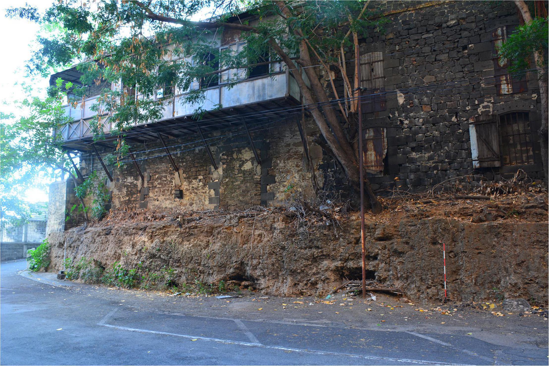
Figure 2. Fossil reef located in Port Louis, used during the colonial period as foundations for a hospital block attached to the immigration depot. This type of formation evidences the fringing reef that would have characterized the island as it formed during successive volcanic eruptions.
Conservation Status
Mauritius is a particularly complex case when attempting to assess the historical and evolving conservation status of the island. Although there is some debate as to the extent of forest on the island prior to colonization (de Boer et al., 2014), research suggests that Mauritius has lost some 95.6% of its original native vegetation landcover following human landing on the island (Hammond et al., 2015). What remains has been aptly described as a “confetti of fragments” (Florens et al., 2012). Because of the rate and scale of deforestation, relatively little is currently known about the dynamics of the natural ecosystem over time (Florens et al., 2012; de Boer et al., 2013b). Some 1,675 flowering plant taxa have been introduced (Kueffer and Mauremootoo, 2004), compared to 691 native species, of which nearly 40% are endemic (Baider et al., 2010). The establishment of the Jardin Botanique des Pamplemousses’ by Pierre Poivre in 1770, renamed the Sir Seewoosagur Ramgoolam Botanic Garden post-independence in 1988, marked the creation of the first botanical garden in the southern hemisphere. The island also has an enviable record of botanical inventories (Bojer, 1837; Baker, 1877; Johnston, 1896; Vaughan, 1937; Baider et al., 2010). Remarkably, even with this history of cataloging, and despite the small size of the island, new native species of flora are still being discovered (Roberts et al., 2004; Baider et al., 2012), including not only relatively small herbaceous endemics (Florens and Baider, 2006; Pailler et al., 2020) but also much more conspicuous shrubs (Baider and Florens, 2016) and even larger trees (Baider and Florens, 2013; Byng et al., 2015). Important research on the impacts of anthropogenic activity on the island since colonization provides further cause for optimism, highlighting the uniquely rich and resilient nature of the local ecosystem. The wet forests of the island retain a density of woody plants, some 8,000 individual plants per ha (at least 1 cm stem diameter), and have the highest diversity index in the Mascarenes, and one of the highest for oceanic islands anywhere in the world. These facts, alongside the high rate of species endemism, and its position within the Madagascar and Indian Ocean islands biodiversity hotspots (Myers et al., 2000; Jenkins et al., 2013), all support the high priority for conservation (BGCI, 2021).
Colonization Processes and Colonial History
Adapting a historical ecology framework, the following emphasizes the onset of deforestation, establishment of plantations, rise of monocrop agriculture, and the development of modern infrastructures (Lane, 2010). This section is framed around the processes of colonization, emphasizing demography, species change, and initial, escalated, then profound ecological degradation, against a chronology of shifting colonial hegemony (Figure 3).
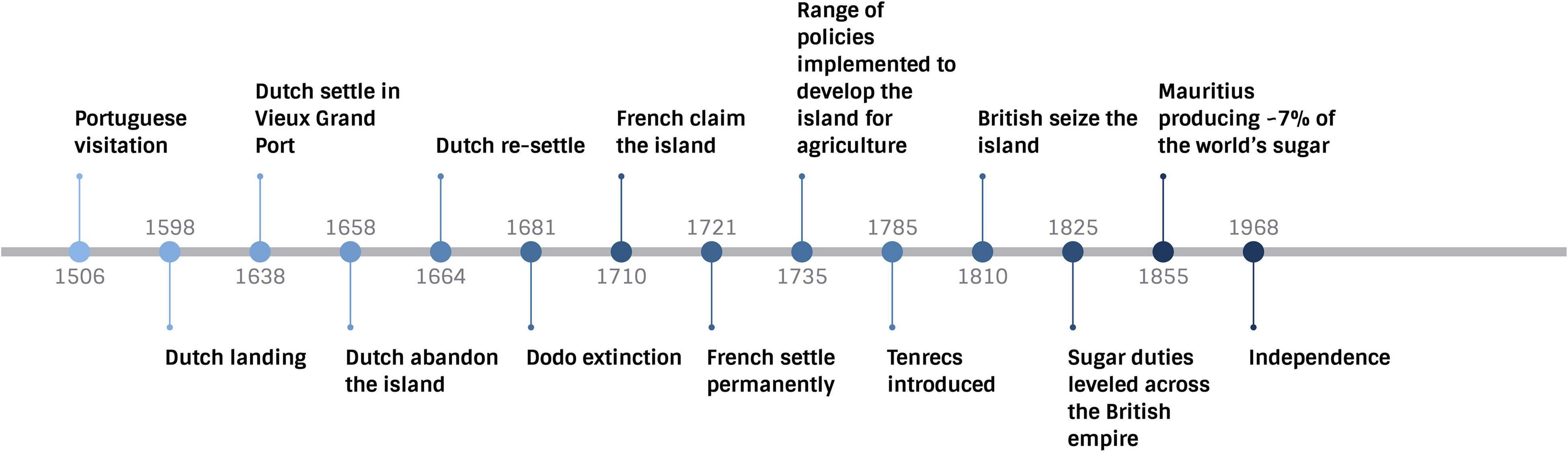
Figure 3. Summary of main historical milestones catalyzing major ecological changes.
Initial Colonization
First settled in 1638, Mauritius was the earliest of the Mascarene islands to experience permanent habitation. It is a portent for other oceanic islands, epitomizing extreme and rapid anthropogenic landscape transformation wrought in less than four centuries (Florens, 2013). Why the island was not colonized earlier remains unknown. Mauritius is 2,000 km from the coast of East Africa, and 829 km from Madagascar. These two locations could have served as launching points for early visits. Earlier exploration has been suggested for the Phoenicians (Tooranwa, 2003, p. 21), and Swahili peoples (Allen, 1999, p. 9); however, there is no evidence to support this. Temporal variations in the monsoon, likely influenced the ability of early seafarers to cross the open ocean and navigate to the island. Maritime resources would have more than compensated for the absence of native land mammals as a food source. From at least the thirteenth century, Arab merchants allegedly visited, or at least knew of the island (Hume et al., 2013). In 1506, the Portuguese visited Mauritius and named it Ilha do Cisne (Island of the Swan), using it as a refreshing post (Grove, 1995, pp. 129–130). Neither of these groups settled. The Dutch reached the island in 1598, attempting a permanent settlement from 1638 at Vieux Grand Port. This first group of settlers constituted 25 men (Floore and Jayasena, 2010). They abandoned the island in 1658, re-settled in 1664, but only until 1710. The focus of the Dutch was the exploitation of coastal ebony forest (Carter, 2006, p. 807). They also brought some 300 enslaved individuals from Madagascar and Java, abandoning these people when they left the island. The ecological effects of these first settlement attempts may be assimilated to landnám (Islandic for land-taking), which typifies the early colonization of Iceland, with incipient forest clearance and sparse agricultural use, followed by abandonment and the spontaneous regeneration of secondary woodland (Smith, 1995). The number of inhabitants remained small during initial colonization. Despite this, the ecological impacts were profound. Deforestation of mangrove, as well as coastal ebony forests, characterized this early period, with ∼5% of the island’s forests denuded (Rijsdijk et al., 2015) during this short timeframe. However, the impacts of invasive species appear to be more widespread. One reason that the Dutch settlement failed was due to plagues of rats destroying crops (Cheke and Hume, 2008, p. 80). This suggests that invasive rats were inadvertently introduced during visitation by the Portuguese, or from passing ships that were wrecked on the reefs (Grove, 1995, p. 130). Rats have a particularly detrimental impact on local ecosystems, especially one with a vertebrate fauna principally comprising birds and reptiles. It was also common practice for sailors to leave goats and pigs on islands in anticipation of culling this walking larder on future visits (Cheke, 2010). Both of these domesticates feralize easily, and pigs, in particular, impact ground nesting birds; indeed, no indigenous ground nesting birds survived the introduction of pigs (Cheke, 1987, p. 160).
The most infamous causality of this early colonization phase was the dodo. A unique mid-Holocene vertebrate bone concentration-Lagerstätte at Mare aux Songes, possibly the very first, youngest, and richest such bone bed discovered on an oceanic island (Rijsdijk et al., 2009), provides a snapshot of the Mauritian ecosystem about 4,000 years ago (Rijsdijk et al., 2011). Equally, this fossil assemblage provides a point of departure to consider the processes of extinction during colonization, and offers insights on how such evidence can inform future mitigation (Rijsdijk et al., 2015). Results from analysis of the Lagerstätte at Mare aux Songes show that the bed itself was created over a short 100-year timespan, suggestive of a mass mortality incident (Rijsdijk et al., 2011). Such events appear connected to localized climatic catastrophe (de Boer et al., 2014). The evidence shows that the dodo had survived thousands of years of cyclical climatic and volcanic extreme events (Rijsdijk et al., 2011, 2015); by the mid seventeenth century, the bird was extinct, a mere century following the discovery by Europeans (Roberts and Solow, 2003; Hume et al., 2004).
Escalating Colonization
For the next century, the island underwent an epoch of expanded terrestrial colonization. The French, who claimed the island in 1715 and settled permanently from 1721, had a more sustained impact on the island’s ecology than the Dutch. From 1735, Governor Bertrand-François Mahé de La Bourdonnais initiated a range of policies to develop the island for agriculture. Principal amongst these was the introduction of cattle and water buffalo for traction. Cattle have both direct and indirect negative impacts on ecosystems. Corralling and maintaining herds lead to increased nitrogen from their waste, which often disproportionately benefit invasive alien plants and can impact lagoons in the form of runoff. When they forage, they create paths that facilitate dispersal of less physically robust commensals, such as goats, pigs, and cats, into habitats that would otherwise be difficult to access. This inadvertently exposes indigenous fauna and flora to new invasive species that have a greater negative impact on native ecosystems. Vast tracts of land were parceled and transformed into plantations.
The drastic transformation and deforestation of the hinterland also had a negative impact on the coast and lagoon. Without natural barriers, the torrential rains of cyclones pour the soils from the mountains into the rivers, which in turn carry sediments into the lagoon waters. The lagoons were further polluted and harmed by coastal urbanization and unsustainable fishing as Mauritius lacked pre-colonial artisanal fisheries (Houbert, 2009).
Enslaved Africans, Malagasy, and Indians were brought from French colonies, as well as the East Coast of Africa, and Madagascar (Allen, 2015, p. 22); a labor force engaged to irrevocably transform the island. Tenrecs, introduced around 1785, and which proliferated in the wild, were an important source of food for these laboring peoples (Cheke, 2010), which suggests a nutritional strategy that involved a degree of foraging. This activity may have had an impact on local native species, but it is more likely that introduced mammals such as monkeys were the target. Evidence from Le Morne, a cemetery used by enslaved and post-emancipated peoples around 1815, supports this with the recovery of deer bones found within a burial context.
Profound Colonization
Mauritius entered a penultimate chapter of colonization. Driven by one crop, sugar cane, the scale and rate of change increased exponentially, and encompassed the coastal and lagoon intertidal zones. French hegemony ended in 1810, when the British seized Mauritius, recognizing its strategic regional significance, but less interested in the island itself. The British instituted their own legal system, but virtually all other facets of life remained unchanged, including the plantocracy: the island remained French, but under British rule. This combination effectively merged imperial strengths, to the detriment of the island’s ecosystem. An established understanding based on some 100 years of colonial science developed specifically to transform and align the ecosystem to French agricultural ideals, was integrated into the huge infrastructure and globalized trade network of the British empire. Sugarcane had been introduced by the Dutch, and was important to the French, but they also cultivated a variety of crops, and the Bras d’Eau sugar estate for example began as a working farm (Haines, 2019). For the British, sugar was the major cash crop (Walvin, 2019). The transformation of Mauritius into a sugar island is an exemplar of how policy can directly degrade ecology. In 1825, Britain leveled sugar duties throughout its empire. This catalyzed an unprecedented ecological and demographic transformation. Between 1855 and 57, an island of only 1,865 km2 produced some ∼7% of the world’s sugar (Allen, 2008, p. 152). Unlike other volcanic islands in the Mascarenes, or the granitic Seychelles, Mauritius has a relatively flat topography over a large surface area of the island. As important, and unlike nearby Réunion, it had at least two natural harbors, Port Louis (west coast) and Grand Port near Mahébourg (southeast), as well as numerous access points for small water vessels to disembark people.
The British administration coincided with the abolition of the trade in enslaved people. To meet labor demands for the rapidly escalating production of sugar, the British instituted The Great Experiment, replacing forced with indentured labor. This catalyzed one of the most rapid demographic transformations anywhere in the Indian Ocean (Kuczynski, 1948), with some 451,000 indentured migrant workers, mainly from India, forming this labor diaspora (Allen, 1999, p. 16).
Continued Ecological Transformation
Adopting a view that colonization is a protracted process, the island’s chronology of ecological degradation has continued since independence from Britain in 1968, and is ongoing today. The new country emerged from colonial rule as a largely socialist nation. Since then, the ideals of capitalism have marched the island toward modernization, urbanization, and globalization. Independence was the point at which local laboring and mercantile groups rose to political power, but not ownership of the plantations. Some plantations, notably Bras d’Eau, are now state lands. However, estate divisions established during colonialism have largely remained in place to the modern day. In cases, this has placed a burden on both archeological heritage (Bakker and Odendaal, 2008), and conservation initiatives. However, as vast tracks of land are owned by French-descent Mauritians, who constitute just two percent of the overall population, there exists an opportunity to galvanize a relatively small proportion of the populace—but one with political influence as well as land ownership—into action. Moreover, this specific well-educated and globally connected group has often been vocal about the need for ecological sustainability (Le Breton, in press) and has been at the forefront of highlighting the need for better conservation strategies (Florens, 2013). Strides to evaluate and manage local flora and fauna, for example, through the establishment of the NGO the Mauritian Wildlife Foundation, have led to world-acclaimed successes with conservation of the Mauritian Kestrel and Pink Pigeon (Sodhi et al., 2011). However, despite these accomplishments, with the highest population density in Africa (Statista, 2020), the island’s ecology will continue to degrade through human activity, and relative inactivity on the part of conservation (Florens, 2013; Sachs et al., 2021).
Surveying a Landscape Created by Colonialism
Given the significant conservation status of Mauritius, and the potential of archeo-historic evidence, it is an ideal location to apply the principles of landscape historical ecology by assessing the ecological impacts of colonialism. We need to generate more baseline evidence, but these data need to be cohesive and better aligned with the long-term socio-political and demographic contexts that drove the changes observed in the archeo-historic record. Such data and evidence will best serve to influence policy and practice today. Improving the understanding of what drove biodiversity loss in the various groups of animals and plants over the period of human impact and how these varied through time and space as the various drivers wax and wane, can provide interesting insights in not only how to better protect what is left of one of the most highly threatened biodiversity in the world (BGCI, 2021), but also in restoring the ecosystems into their most functional state possible to ensure reinstating ecosystem services and long term conservation of biodiversity (Albert et al., 2021).
Here we present a broad-spectrum environmental reconnaissance strategy, initially motivated and funded by the Australian National University (PI: Prof. Atholl Anderson) for research focused on the potential early exploration of Mauritius. Sites initially surveyed included Flat Island, Trou aux Cerfs, and Le Morne. MACH subsequently continued several seasons of work on Flat Island, and Le Morne, as well as the remaining sites listed below. At the time of writing, 12 sites have been surveyed as part of the work of MACH. We concentrate on eight locations that have already provided, or have the potential to provide, evidence on the ecological context and change over time (see Figure 1).
As outlined above, the following summary of sites and themes emphasizes the relationships between landscape transformation, demographic flux, and colonial directives. This meets our mandate to disentangle and reveal the underlying ecological degradation aligned against the details of colonial chronology and changing policy. In both implicit and explicit ways, we attempt to synthesize work from Mauritius with Crumley’s five unifying processes, i.e., human impacts; global impacts; effective responses; anticipated changes, and potential changes. Although some of the sites discussed below have actively been targeted for ecological evidence, our team has also responded to the needs of local heritage institutions requesting support and archeological expertise. In showcasing these sites, we anticipate stimulating new collaborative research focused on developing the historical ecology framework.
Sites and Themes Aligned With Crumley’s Processes
1st Process, “Human Impacts”
Bras d’Eau National Park is located within a former estate, spanning some 5,000 acres (20.2 km2), which has undergone numerous phases of ecological transformation due to agricultural intensification, use of local resources by laboring peoples, and as a consequence of both colonial and post-independence land management (Haines, 2019, 2021). The site is characterized by basalt outcrops; vesicular basalt also forms part of the fabric of the underlying soil. This geomorphology has historically been considered an impediment to agriculture, and a major effort of colonial practice on plantations was to direct enslaved and indentured peoples to stockpile the larger boulders, use medium stones to build walls, and cobbles for roads. Stonemasons also cut the basalt into blocks for buildings. This has had the effect of transforming, on a massive scale, the composition of the island’s soil. However, despite the extensive landscape engineering that has occurred on Bras d’Eau, the large size of the site has meant that many areas exist that are ideal for ecological study, located well away from the developed part of the estate. Bras d’Eau retains an ancient ebony tree, which, along with pre-colonization specimens located in the southwest of the island, could be crucial for developing dating profiles.
Trianon was also a former sugar estate, inscribed in 1974 as a National Monument because of the presence of a series of barracks, built from basalt blocks, potentially used as dwellings or storage (Calaon et al., 2012; Seetah et al., 2015). This site has produced the first plant macrofossils indicative of imports and food culture (Seetah, 2015), as well as preliminary finds that point to cattle management.
Biogeography of commensals forms a focus of work concentrating on understanding how introduced species have, and continue, to adapt and alter the environment. By collaborating with a local pest control company, the MACH project has been collecting specimens of rats (Rattus rattus and Rattus norvegicus, the Indian musk shrew (Suncus murinus) from around the island, recording biogeographical evidence, and skeletonizing the specimens. These samples will then form the basis for molecular and geometric morphometric analysis to identify regional variation. Behavioral traits are also recorded. These data will be mapped onto evidence derived from archeological excavations.
Bras d’Eau typifies Crumley’s “human impacts” by demonstrating the scale of transformative changes to promote agriculture mediated via technology. In this case, the technology was relatively basic, thus emphasizing the extent of direct human agency in landscape reconfiguration. Bras d’Eau also illustrates how legacies of colonial policy endured to cause ecological harm. Despite being listed as a national park and with some plantings of native and endemic species, it continued to be used for the propagation of exotics, such as mango, that have since completely altered much of the local landscape. Similarly, Trianon also illustrates the scale of change for agriculture, but is even more pertinent within the context of urbanization and development. The entire surrounding region now forms part of a major commercial center, new housing, and major transport developments. In the future, our work will seek to understand the nature of soil change from Trianon and Bras d’Eau as a consequence of agriculture. Understanding “human impacts” is also approached directly from demographic evidence (see future work, below), and indirectly, from the commensals brought to the island.
2nd Process, “Global Impacts”
Flat Island has been left relatively untouched by development with no modern roads or buildings; thus, the paleoecological context remains relatively undamaged. The islet is approx. 12 km from the northernmost tip of Mauritius and covers 253 ha. It was used as a quarantine station in the nineteenth century for humans and livestock. Surveys have identified several suitable areas for coring, but it was clear that mechanical equipment would be needed due to the high degree of basaltic inclusions in the soil.
Bois Marchand was the largest cemetery in the Indian Ocean when established in 1867, covering some 162 ha. As with Flat Island, this site was created in response to massive epidemics, in this case of malaria, which plagued the island from the 1850s. Invariably, these epidemics were a consequence of alterations to the landscape that allowed disease vectors to proliferate; the increased rate of mobility as ship technology improved, and the arrival of new groups of people who carried disease. Research at Bois Marchand has concentrated on recovery of human remains from the epidemics of the late 1860s. The site is also extremely valuable as it was established as a “garden cemetery” (Čaval, in press), which in tropical locations, favored the use of endemic flora (Mytum, 2003, 2004, p. 48). To our knowledge, no recent inventory of the cemetery flora has been done, despite the size and relatively untouched nature of a site established with a view to promulgate endemic plants.
Evidence of landscape change a program of coring is underway with colleagues from Reading University (Pluskowski et al., in press) focused on lakes and wetlands (e.g., the volcanic crater lake of Trou aux Cerfs, and the marshy areas of Le Morne) with potential for recovering sediment sequences containing records of paleoenvironmental and paleoclimatic change (Figure 4). This coring profile is being developed at the local scale (e.g., type of crops cultivated, introduction/extinction of plant species, phylogenetic studies, deforestation/burning, floral diversity and abundance, intensive sugar cane exploitation) and continental scales (e.g., history of paleocyclones). Silted lagoons and wetlands in the buffer zone of the Le Morne World Heritage Site provide an ideal location for developing research at the local scale, whilst lake sediments accumulated within Trou aux Cerfs crater offer the potential for investigating paleoclimatic change at the continental scale.
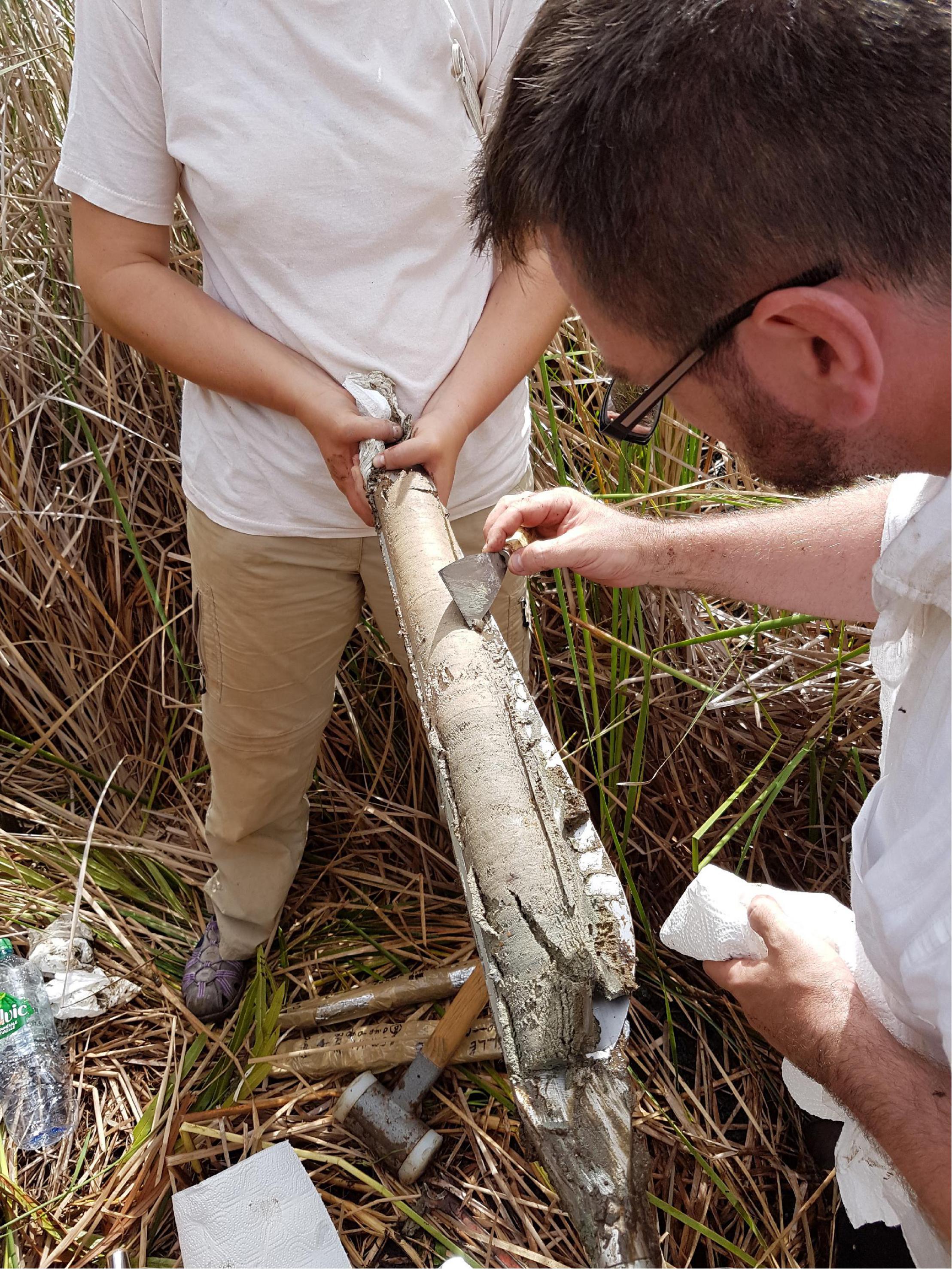
Figure 4. Sediment core extracted from a freshwater marsh located near Belle Mare in 2016. Core analyzed by Dr. Alex Brown, Wessex Archeology based geoarcheologist, as part of initial research undertaken in partnership with Reading University. The core comprises an herbaceous peat (0–0.2 m), dark gray-brown detrital organic lake muds (0.2–0.57 m) overlying olive green silts (0.57 m +). Pollen was poorly preserved, although upper samples of the sequence did include aquatic pollen of Potamogeton, fern spores, along with variable quantities of microscopic charcoal.
Assessing “global impacts” is driven from the view that Mauritius was a hub for the movement of large numbers of laboring peoples (Allen, 1999), and goods. Baseline evidence, from coral cores and other climate proxies will allow us to situate these actions against a chronology of local change that had regional resonance (see future work). Mauritius formed a node between the Indian, and Atlantic and Pacific oceans, both within the context of labor diaspora, and products. Understanding the transmission of disease at a regional scale, and the influence of global weather systems such as El Niño on local climate, are also key outcomes of studies under the umbrella of “global impacts.”
3rd Process, “Effective Responses”
Le Morne was inscribed as a UNESCO World Heritage Site (WHS) in 2008, commemorating resistance to enslavement. Falling within the buffer zone of the WHS are several swamps and lagoon areas that likely preserve continuous and easily accessible sedimentary sequences of environmentally salient data. This kind of sequence is indicated for research on environmental and anthropogenic change at the local scale (e.g., introduction/extinction of plant taxa). This is particularly important given that the area was not subject to intensive sugar cropping. Thus, although established settlement has taken place since the period following emancipation, prior to this, the region was sparsely inhabited. Several seasons of survey and excavation in the area have led to the discovery of a cemetery used during and after the period of enslavement. Human remains provide evidence of regional demography (Fregel et al., 2014), and future work on settlements sites will help to reveal the food gathering strategies of individuals not directly attached to the plantation economy (Lightfoot et al., 2020).
Climate proxy evidence is also being collected from coastal areas where emerged portions of ancient coral reefs are evident, and possibly having formed during the last interglacial period (Eemian c. 130 ka BP) or connected with tectonic uplift. This predominantly geological topic can be developed in connection with the positioning of mines for coral extraction and lime production during the colonial period (Walker, 1962), which have had major degradative impacts. Indeed, old coral and calcarenite quarries, such as those at La Prairie, may be a source of cores for climate proxy evidence. The most promising avenue for climate proxy evidence comes from surveys in Pointe d’Esny and Trou aux Biches (see future work). Our team has identified several large corals in both locations, and existing cores are currently housed at the Mauritius Oceanographic Institute. Working with climate scientists Prof. Rob Dunbar and Dr. Neil Tangri from Stanford University, temperature logging instruments have also been placed in these locations to monitor sea temperature fluctuations over the last 5 years.
Other sites listed are obviously pertinent to our understanding of the response to ecological degradation. We focus on Le Morne because it provides evidence from a group that has very little presence in the historical record, and which is generally thought of as having little material culture. Thus, Le Morne helps us assess “effective response” from the view of enslaved people, at the time that the most profound ecological changes to the island were coinciding with massive social upheavals and demographic reconfiguration. Le Morne has also been a key site for modern activity to regenerate local mangrove forests (Figure 5). Clearly, we will need to integrate many locations to investigate this process. However, creating a profile of climatic and ecological changes within a well-defined chronology has particular value for the region of Le Morne as this remains an area of low population density, with evidence of the will to conserve the existing habitat. Most importantly, the region remains one of the poorest in Mauritius, and building local resilience should be a priority to support the local community.

Figure 5. Aerial image of mangrove regeneration; new mangrove evident as delineated and regular plantings (outlined in red). Drone image from 2017.
4th Process, “Anticipated Change”
Trou aux Cerfs is the largest crater on the island and harbors a volcanic lake. It has been described as a monogenetic volcano with a central vent, formed during late stages of volcanic activity from 700 to 600 KYA (Saddul, 1995), and is now dormant. The crater is 614 m asl (Nel et al., 2012) forms a circular depression, with a diameter of some 350 m and 180 m at the outermost rim and base, respectively, and a depth of 80 m at the base (Johnson et al., 2010). Situated in a prominent portion of the island, and less affected by agricultural activities in proximity, the sedimentary sequence at the bottom of the crater is likely to provide continental-scale paleoclimatic records (e.g., cyclones, precipitation, temperature). In addition, any botanical records are likely less affected by human activity, although deforestation did occur in the post-war period and replanted with pine. These records would form useable comparisons with those accumulated in the lowlands and near the coast. Important results have been derived from cores extracted from Trou Kanaka (de Boer et al., 2013a,b, 2014) to the south of Trou aux Cerfs. Aligning evidence from a wider geographic profile of cores would provide baseline data from a broad sweep of the island, and more broadly for the archipelago and the Indian Ocean. The area immediately around the crater edge has a path ringing the entire perimeter, which would allow a relatively easy descent into the crater with hand-held coring equipment. An initial reconnaissance of the visible crater slope was made, identifying a minimum of six terraces. From this preliminary survey, an estimate of the minimum sediment accumulation on the volcano lake margin was possible, with the topmost sediment characterized by small angular basalt blocks.
This location brings evidence in support of understanding “anticipated changes” specifically with regards to how a continuation of sugar agriculture will further deteriorate local ecology, and also, escalating urbanization as Trou aux Cerfs is within a region, Curepipe, that has seen rapid development. The site is also critical to provide baseline evidence from which sustained mitigation strategies can be developed to support conservation.
5th Process, “Potential Change”
Impacts on the maritime context are being investigated through coastal reconnaissance and a large-scale program of mapping of underwater wrecks (Manfio and Seetah, in press; Manfio and von Arnim, 2020, p. 505). Coastal reconnaissance has mainly been undertaken as foot surveys, circumnavigating the island. This was conducted to understand topography, coastal morphology, erosion, and land use. The integration of these data with archive records in GIS systems is providing information on coastal transformation and use over the centuries. In addition, ethnographic study of traditional boats, local seafaring practices, boat types, and their regional differences is ongoing to better understand the development of incipient seafaring traditions and cultural affinity with coastal and lagoon environments.
The maritime context is critical for assessing how multiple uses of the coast over time will impact, and change, what is arguably one of the island’s most important natural resources, the lagoon. New developments in aquaculture are already providing economic benefits. Additionally, new uses of the coast for activities associated with tourism, the exploitation of deep-sea fishing resources, and the fact that Mauritius remains an important nautical thoroughfare, all continue a long history of marine exploitation. These diverse uses are radically evolving, and there is a pressing need to situate the heritage context into this dynamic equation to avoid loss of a significant cultural resource. Over 800 historical shipwrecks have been recorded from archival records and surveys in the waters around Mauritius. From this substantial database, GIS mapping is underway integrating historical, archeological, as well as environmental data to help local government manage this heritage resource, protect the wrecks, and mitigate potential impacts on the lagoon environment as the lagoon comes under increasing pressure (Manfio and von Arnim, 2020).
Table 1 summarizes the section above aligned with the historical ecology framework. As can be seen, overlap is unavoidable and anticipated.
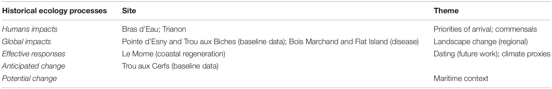
Table 1. Sites and themes nested within Crumley’s five historical ecology processes.
Future Work
In concluding this section on the ongoing work of MACH, the following summarizes future projects that would support the development of a landscape historical ecology framework.
Prehistory of Mauritius
New research is needed to develop a preliminary model for sea-level change and emerged land in the Mascarene Plateau (Norder et al., 2018), back to the LGM period (Last Glacial Maximum, c. 18 ka BP), when sea level was as much as 130 m below present-day levels, and beyond. Understanding of how the prehistoric sea-level changes influenced the region’s biota is evolving. For example, in Mauritius and elsewhere, recent findings (Norder et al., 2018) have showed that single island endemism in some groups (flowering plants and mollusks) are best explained by longer-lasting sea-level stands, instead of the lowest sea-level stands achieved during glaciations. In Mauritius, it has been suggested that, during the last glaciation, Flat Island, along with other islets off the north coast, was connected to Mauritius (Strahm, 1993). Also, changes in palaeo-currents in the Indian Ocean and historical navigation tracks (Vincent, 1998) need to be considered. These datasets would help define potential sea-routes and investigate the possibility and impact of early visitation. Future research may involve the identification of coral reef emergence points and the definition of their position above sea level, inclination, and mapping.
Priorities of Human Colonization
Priorities of human colonization are being investigated through the analysis of both modern and ancient DNA. An initial exploratory study with 100 individuals sampled from a cross section of the island’s peoples revealed a highly admixed contemporary population (Fregel et al., 2014). This has motivated a larger study currently under investigation. Ancient sampling from cemeteries in Le Morne and Bois Marchand has provided the first concrete scientific evidence for the origins of the enslaved and indentured diasporas (Fregel et al., 2015).
Climate Proxy Evidence
Climate proxy evidence Trou aux Cerfs has the potential of providing a long paleocyclone and paleoclimatic record from the center of the island. A minimum of six terraces were observed on the lowest portion of the volcano mouth. A 250 cm long stick was manually driven into the lake sediments from the top of the lowest terrace providing an estimate of the minimum sediment accumulation on the volcano lake margin. When trying to hammer in a PVC pipe we were prevented by angular basalt blocks (10 s of cm) and could only recover the top 30 cm of the sequence that will be used to test proxy presence/preservation. Proper coring equipment is needed to recover a suitable sequence. Pointe d’Esny in the south and Trou aux Biches in the north, two coastal sites, form part of surveys to identify suitable Porites corals that can be cored to generate proxy data on climate and ecological changes over the last 200–300 years. Fossilized coral and reef have been identified from Port Louis, a coral reef profile reaching c. 4 m asl. A 1 m deep channel filled with cross-bedded sand-sized bioclasts characterizes the top of the profile (Figure 2). On Flat Island, a coral reef platform 2 m asl has been recorded, which coincides with the position of a jetty and graveyard in Plage Verte.
Dating
Dating should form a major focus of research, given that the C14 profile for the last 300 years, particularly in tropical climates, is poor (Higham, pers. comm.). Dating profiles are being developed from coral (Seetah, 2018; Pluskowski et al., in press) and ecofacts as part of the work of MACH (focused on the historical period) to complement the extensive dating undertaken on sediment core to study climate variability and ecology (mainly pre-colonial) (de Boer et al., 2014) and mid-Holocene fauna (Rijsdijk et al., 2011). In the future, these studies could be knitted into a comprehensive regional database, such as is currently being undertaken for Mediterranean Africa (Lucarini et al., 2020). Dendrochronology profiles, challenging in tropical climates, are being developed in collaboration with colleagues at the Mauritius Herbarium, and from single large specimens, such as the ebony tree from Bras d’Eau (Figure 6). Mauritius presents several preserved wildlife areas where ebony and other hardwood trees as old as 500 years. may still be found, e.g., Brise Fer forest. Starting from the study of those trees, a new dendrochronological reference curve can be built, which can be used for paleoclimatic purposes, as well as for tracking historical wood trade routes, particularly relevant for ebony. However, research is needed to check the viability of ebony trees for dendrochronology; growth rings may be too thin as the diameter of a 400 yr old ebony tree can be as narrow as 40 cm. A recently funded and government-approved 16-month long project (PI: VF) is currently gathering stem diameter growth rate of thousands of forest trees (each previously measured 4–20 years ago), that will provide data useful to calibrate age of native tree species using their trunk diameter. Permission has also been granted to core hundreds of individuals and the cores will be available for further dating methods of the trees using dendrochronology and carbon-14 dating. The cores will also be available to be used to infer past climatic conditions like droughts that would have happened during the lifetime of the sampled trees. A dendrochronology program should be developed in parallel with sediment studies. A small but important series of palaeoecological studies undertaken on cores from upland and lowland settings cover the last 38,000 years (van der Plas et al., 2012; de Boer et al., 2013a,b, 2014). These studies provide a valuable long-term perspective on vegetation responses to past climate change and the environmental impact of colonization, though evidence for the latter is largely restricted to sequences from upland settings. The evidence for human impact in upland sequences currently has no lowland parallel due to absent and/or poor pollen preservation from deposits covering the period of human colonization and settlement of Mauritius. Pollen was largely absent from the Mare Tatos sequence covering the last 500 years (de Boer et al., 2014), while at Mare aux Songes, the infilling of the marsh with dolerite boulders (a malaria control measure) largely disturbed the last 4,000 years of deposits (de Boer et al., 2015). A preliminary coring initiative in 2016 with a collaborating team from Reading University recovered sequences from lowland wetlands at Point D’Esny in the south and Belle Mare close on the east coast. Pollen was poorly preserved in both sequences, though the upper samples from Belle Mare included aquatic pollen of Potamogeton, fern spores and variable quantities of microscopic charcoal (Figure 4). Unfortunately, no short-lived plant macrofossils suitable for radiocarbon dating were observed. However, given the dating profiles developed from the coring programs mentioned above, we are confident that suitable samples for C14 will be recovered from future coring operations (see Pluskowski et al., in press for a more comprehensive discussion).
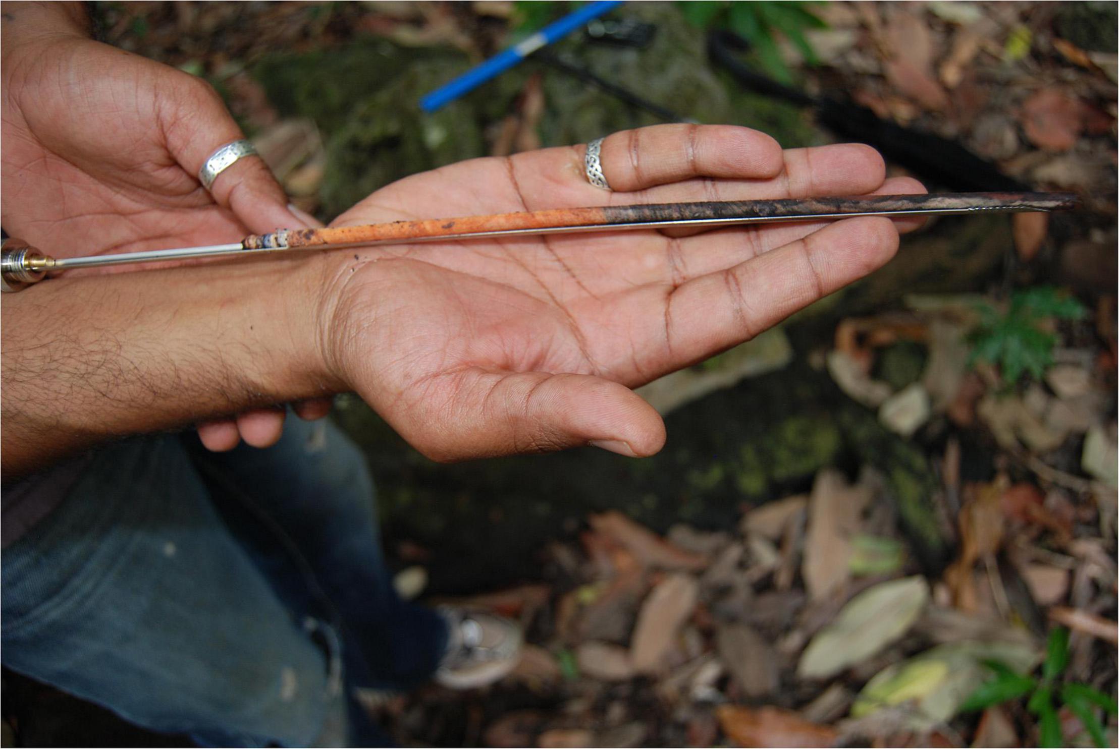
Figure 6. A wood core extracted from an endemic ebony tree for dendrochronology, Bras d’Eau Sugar Estate. Although banding of the rings is faint, typical of tropical hardwoods, the image illustrates the potential for use of this species as part of a dendrochronology dating program.
Spatial Analysis of Anthropogenic Landcover Change
Spatial analysis of anthropogenic landcover change satellite images can be used to detect land clearing, land-use, and agriculture-triggered landscape change (Sheth et al., 2010). Such information can be integrated to investigate human impact, in relation to the introduction and extinction of plants and animal species.
Discussion
Investigating historic human ecology provides a way to assess and understand a major transformative event in the recent past, global colonialism, which has greatly transformed the Earth system. Mauritius, with its defined physical boundaries, limited local resources, and the relatively recent and well-documented history of human colonization and corresponding impacts, falls within the category of islands that offer the ideal conditions for understanding the complex historical interweaving between humans and the surrounding environment (Norder et al., 2017). A historical ecology framework allows researchers to move beyond the limits of ecological concepts (Lane, 2010, p. 31), as well as existing archeological research focused on the “when,” rather than “how and why.” The Remote Island Enigma illustrates one example of the fundamental differences between early and recent island colonization events, and the specificities of the Indian Ocean vs. other oceanic basins. For Mauritius, colonization during colonialism typifies colonization of small places driven by global forces; an entirely different context to colonization by the original seafarers. Landscape historical ecology provides a useable framework to investigate topics that underpin this essential connection between local and global. Principal amongst these is to track the rate and scale, the moving frontier, of growth in sugar production; the differential impacts of commensals on the island’s ecology, and the relationships between introduced and endemic floras as plantations were established and developed.
For each of these topics, it is evident that the historical evidence, describing policies, populations, and providing a clear chronology, must be well integrated with the physical evidence of demographic, climatic, and ecological fluctuations. In this way, there is a possibility to disentangle the discrete aspects of this period of massive social, political, and ecological upheaval. Such a broad integrative strategy is essential if we are to mitigate the ongoing climatic and ecological damage facing this and other island nations and promote resilience and recovery of biodiversity and ecosystems through ecological restoration initiatives.
Creating useable pasts is an essential driver of landscape historical ecology. Beyond its historical value, this approach may provide insight for current challenges i.e., extinctions, biodiversity loss, social justice, pandemics, etc., to promote sustainability. Adopting an applied approach to the creation and utility of a useable past, we present a summary of how one major question could be usefully addressed. Establishing the priority of demography vs. policy as a function of ecological degradation would serve as a valuable repository that could be applied within the context of contemporary mitigation.
In our conceptual model, historical data are reported on the Y-axis, providing the chronological framework of colonization, and ecological/human proxy data on the X-axis, providing information of human impact on and contribution to the island’s ecosystem. The X-axis, “Ecological Impact,” would be a function of the different strands of evidence collected from the project. These include, but may not be limited to:
• Human demography/pressure, i.e., derived from historical records.
• Estimated loss of forest cover (in hectares), i.e., derived from pollen diagrams (data on forest clearance, e.g., by the Dutch).
• Estimated extension of cleared vegetation, i.e., derived from pollen diagrams (data on extension of sugar cane fields, e.g., by the French).
• Fluctuations in flora biodiversity, i.e., derived from pollen diagrams (number of plant native/endemic vs. introduced taxa).
• Extractive pressure:
∘ Estimate mass of wooden resources extracted, i.e., derived from pollen diagrams from ebony.
∘ Estimate mass of sugar from cane, i.e., derived from pollen diagrams and/or historical records of sales.
• Local diet and food, e.g., nutritional trophic level for different populations from isotope analysis (Lightfoot et al., 2020).
• Migration, e.g., demographic data from aDNA (Fregel et al., 2014).
• Fire frequency records, i.e., derived from microcharcoal remains in cores.
These lines of evidence may be represented independently on the X-axis, or as a single value, derived for the combination of different parameters into a single function. Extracting one case example from the above, human population size and the impacts on forest, and using readily available data for illustrative purposes only, Figure 7 provides a revealing graphic representation for human pressure on the island’s flora.
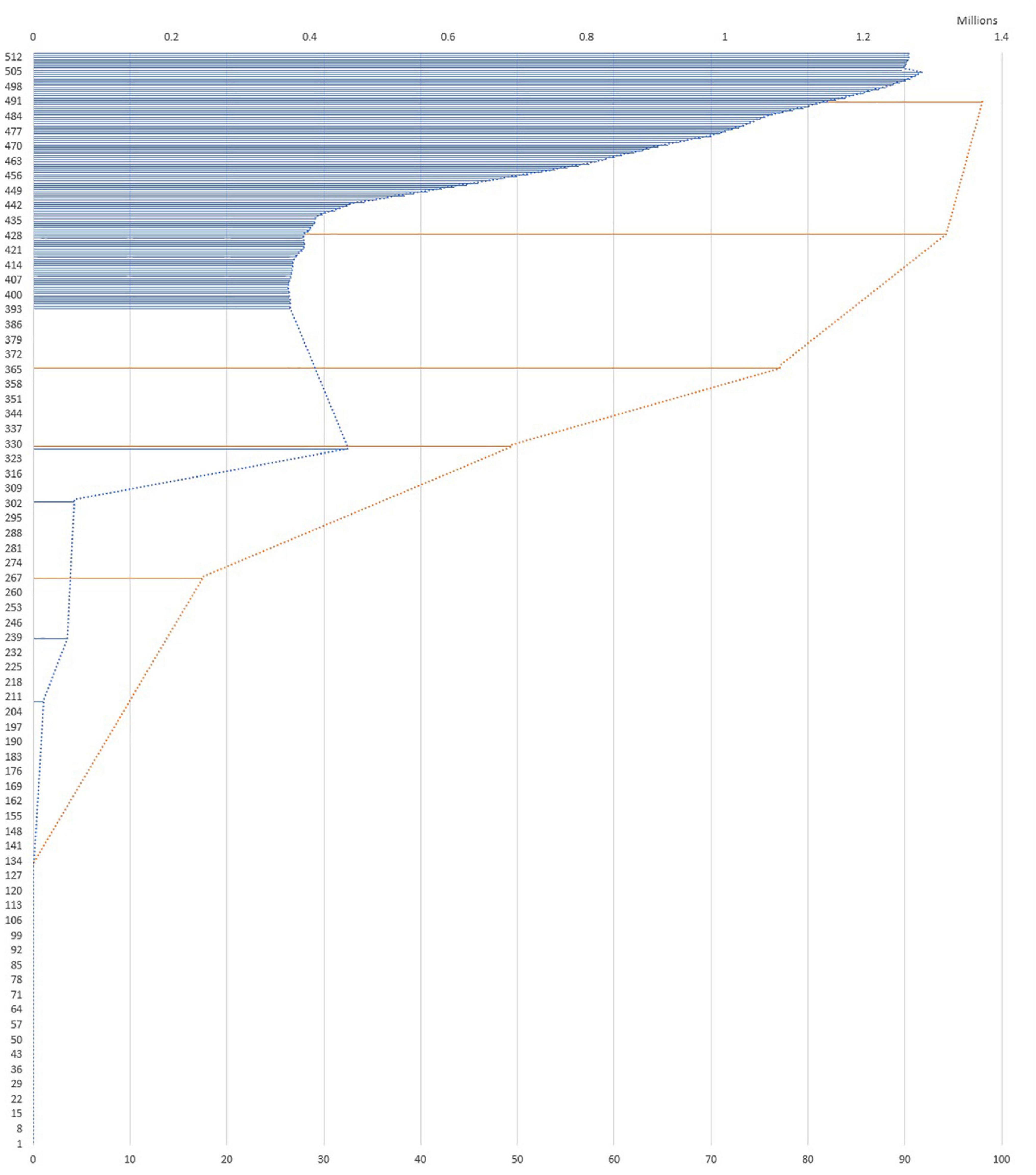
Figure 7. Model aligning human population growth (blue line, millions of people) with forest loss (red line, percent of forest loss). Source data for population development of Mauritius since 1900 are from Statistics Mauritius (https://statsmauritius.govmu.org/SitePages/Index.aspx https://statsmauritius.govmu.org/ SitePages/Index.aspx) and from and United Nations Demographic Yearbook (https://unstats.un.org/unsd/demographic/products/dyb/default.htm). Figures up to 1945 are for the island of Mauritius only. The island of Rodrigues is included thereafter. Figures prior to 1900 were retrieved from Norder et al., 2017. Forest clearance data: based on Norder et al., 2017: forest clearance is derived from forest cover in six historical maps from 1638 onward [See Figure 2 in Norder et al. (2017)]. Timeline is represented on the Y-axis, where Year 1 corresponds to CE 1507 corresponding to the first possible landing on the Island by the Portuguese, and Year 514 is CE 2020).
Four periods can be observed:
Period 1: Year ca. 1–130 (ca. CE 1507–1638): Virtually no impact between the Portuguese visit and the establishment of the Dutch colony with the first community of enslaved people.
Period 2: Year 131–329 (ca. CE 1638–1835): Demography and deforestation progress with a similar trend: demography grows to c. 450,000, and deforestation extends over 50% of the land.
1835: abolition of slavery and introduction of indentured labor
Period 3: Year 330–429 (ca. CE 1836–1935): There is a marked decoupling between demography and deforestation. While demography stabilizes around 400,000 (cf. United Kingdom demographic policies). On the other hand, deforestation doubles over the same period, extending over c. 95% of the land.
Period 4: Year 430 to present (c. 1935–1997): The trend is inverted compared to Period 3. While demography increases from c. 400,000–1,250,000 people, deforestation extends marginally to 95.6% of the land.
As this model suggests, population size may be considered as a critical proxy for ecological degradation in the early phases of colonization. However, the correlation between human population and deforestation, weakens over time, with lower human populations in the nineteenth and twentieth centuries causing more deforestation than larger present-day populations. Qualifying how and why ecological transformations occurred will require a deeper understanding of human behavior and ecological change, based on the detailed study and correlation of different social and ecological parameters. The graph will alter significantly as further parameters are integrated, possibly leading to unexpected emerging patterns. Ultimately, this approach will allow us to produce models as depicted in Figure 8. This simple conceptual model aligns a range of actors and functions. It will obviously evolve as actual, and more, data are utilized.
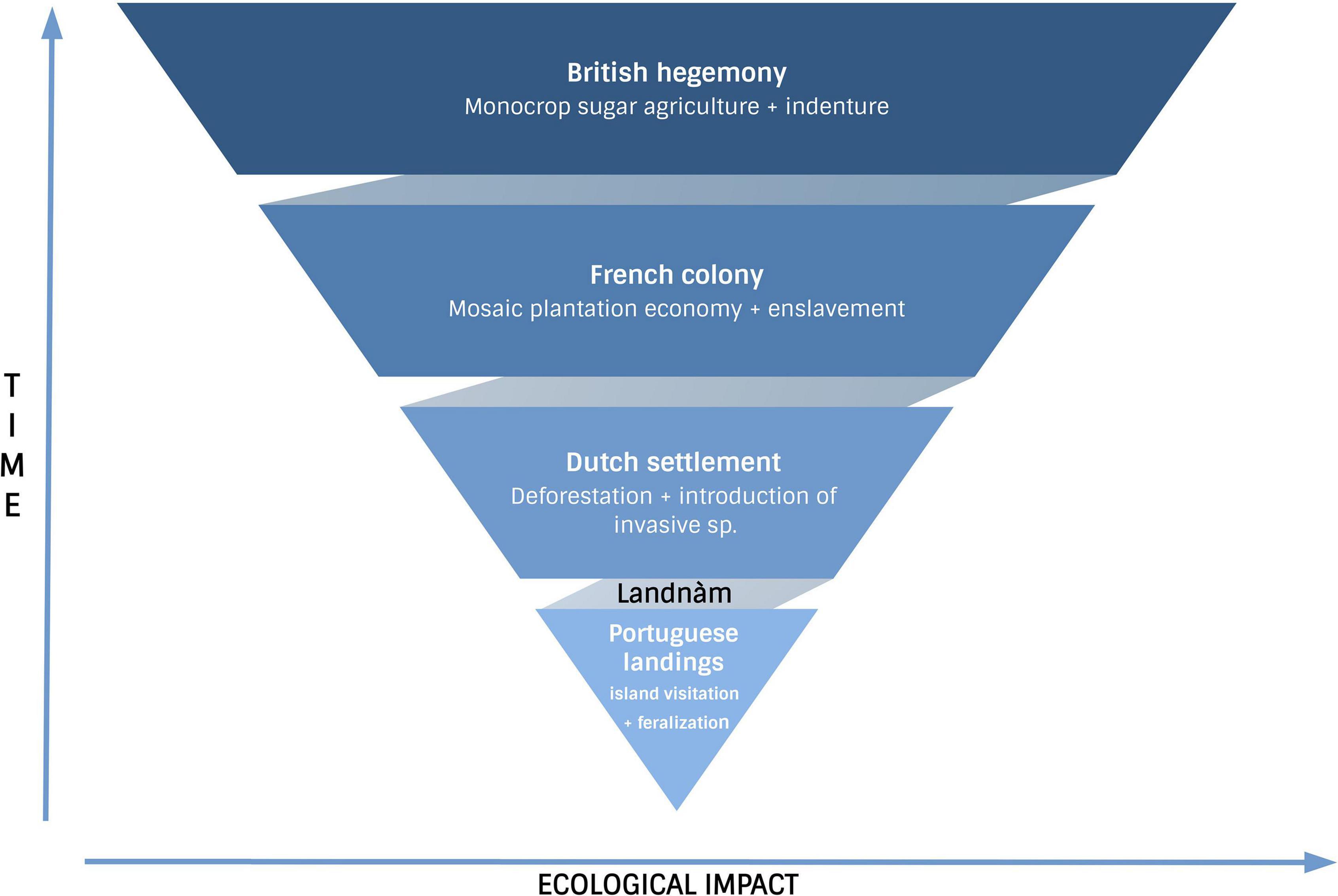
Figure 8. A linear conceptual model aligning colonization process and colonial history.
Conclusion
Mauritius was a genuine pristine ecosystem until a few centuries ago. Through three distinct phases of imperial rule, it underwent massive demographic and ecological flux. In attempting to re-create European landscapes and science in tropical lands, the colonial elite established the first botanical gardens in the southern hemisphere, one of the earliest meteorological societies, and recorded reams of data on local ecology and climate to better understand how to develop local agriculture. The impressive work on the dodo has provided an important corpus of evidence on the island’s pre-human ecosystem, native biogeography and extinction, and the pressures on native fauna and flora since human habitation. Thus, large repositories of historical evidence, and a growing body of research on paleoclimate and paleoecology, form a foundation for new research framing human historical ecology. However, we still do not understand in detail how and why the island transformed so quickly.
There are major gaps in our studies of colonization when that process occurs in tandem with colonialism. Few places outside of the Indian Ocean have experienced the dual forces of colonization and colonialism together; for the Indian Ocean, however, this coupled system characterizes nearly one-third of the ocean’s islands. Thus, a different approach is needed, one that asks different questions, utilizes history, including oral traditions, to build context, and one which integrates the agency of all colonizing peoples.
The human dimension was critical, but this remains a major omission in our research on the island’s past. The island had a once-pristine ecology, but was not—as Mark Twain has often been misquoted as saying—paradise. During colonialism, everyone was galvanized to work toward the same goal and there was scant attention paid to conservation. Although in Mauritius some of the first efforts to protect native forests for ecosystem services (water regulation) were made, enforcement failed to support these good intentions. No one seems to have considered the island as home; enslaved people justifiably sought to escape, laborers were contracted to return to their respective homelands, and Europeans had little desire to migrate to this colony, not least because of the risk of disease. Without an indigenous population, the core practices of landscape change were never challenged. The machine of colonialism was powered by large numbers of individuals all essentially aligned in their efforts to transform and exploit the land for profit. Conversely, without an indigenous population, developing new practices for sustainable use of resources since independence has no precedence, and will take time and knowledge. That knowledge will have to come from a deeper understanding of the underlying process of change, which historical records alone cannot provide. Moreover, the how and why, rather than the when, has greater utility for descendent communities in Mauritius.
Few locations around the world offer this level of evidence, and mitigation of past damage is still possible. If successful remediation can be achieved through the approaches outlined above in combination with allied studies, the island could serve as both portent and beacon for other small islands around the world.
Data Availability Statement
The original contributions presented in the study are included in the article/supplementary material, further inquiries can be directed to the corresponding author/s.
Author Contributions
All authors listed have made a substantial, direct, and intellectual contribution to the work, and approved it for publication.
Funding
Open Access for this article was funded by the Stanford Archaeology Center Director’s Fund. KS received funding from Australian National University, Canberra, Australia (2009), PI: Atholl Anderson “The search for prehistoric colonization events in Mauritius”; British Academy Small Research Grant, London, UK, (2009), “Slavery, indenture and colonialism: the bittersweet past of Mauritius” (SG-54650); British Council Darwin Now Award, London, UK (2009); “The immigrant population of Mauritius”; British Academy, Small Research Grant, London, UK, (2010); and “Mauritius: an exploration of colonial legacies on an island paradise” (SG-10085). HF is funded by the European Research Council (ERC) under the European Union’s Horizon 2020 research and innovation programme under grant agreement No. 759677.
Conflict of Interest
The authors declare that the research was conducted in the absence of any commercial or financial relationships that could be construed as a potential conflict of interest.
Publisher’s Note
All claims expressed in this article are solely those of the authors and do not necessarily represent those of their affiliated organizations, or those of the publisher, the editors and the reviewers. Any product that may be evaluated in this article, or claim that may be made by its manufacturer, is not guaranteed or endorsed by the publisher.
References
Albert, S., Flores, O., Baider, C., Florens, F. V., and Strasberg, D. (2021). Differing severity of frugivore loss contrasts the fate of native forests on the land of the Dodo (Mascarene archipelago). Biol. Conserv. 257:109131. doi: 10.1016/j.biocon.2021.109131
Allen, R. B. (1999). Slaves, freedmen and indentured laborers in colonial Mauritius. Cambridge: Cambridge University Press.
Allen, R. B. (2008). Capital, illegal slaves, indentured labourers and the creation of a sugar plantation economy in Mauritius, 1810–60. J. Imper. Commonwealth Hist. 36, 151–170. doi: 10.1080/03086530802180569
Allen, R. B. (2012). European slave trading, abolitionism, and “New Systems of Slavery” in the Indian Ocean. Portal J. Multidiscipl. Int. Stud. 9:1.
Allen, R. B. (2015). European slave trading in the Indian Ocean. Athens: Ohio University Press, 1500–1850.
Anderson, A. (1991). The chronology of colonization in New Zealand. Antiquity 65, 767–795. doi: 10.1017/s0003598x00080510
Anderson, A., Camens, A., Clark, G., and Haberle, S. (2018). “Investigating pre-modern colonization of the Indian Ocean: The remote islands enigma,” in Connecting Continents: Archaeology and history in the Indian Ocean, ed. K. Seetah (Athens: Ohio University Press), 30–67. doi: 10.2307/j.ctv224twcb.5
Baider, C., and Florens, F. B. V. (2013). Eugenia alletiana (Myrtaceae), a new critically endangered species endemic to the island of Mauritius. Phytotaxa 94, 1–12. doi: 10.11646/phytotaxa.94.1.1
Baider, C., and Florens, F. B. V. (2016). A new and critically endangered species of Turraea (Meliaceae) endemic to the island of Mauritius. Phytotaxa 247, 219–228. doi: 10.11646/phytotaxa.247.3.5
Baider, C., Florens, F. B. V., Baret, S., Beaver, K., Matatiken, D., Strasberg, D., et al. (2010). Status of plant conservation in oceanic islands of the Western Indian Ocean. Proceedings of the 4th Global Botanic Gardens Congress. Richmond.
Baider, C., Florens, F. B. V., Rakotoarivelo, F., Bosser, J., and Pailler, T. (2012). Two new records of Jumellea (Orchidaceae) for Mauritius (Mascarene Islands) and their conservation status. Phytotaxa 52, 21–28. doi: 10.11646/phytotaxa.52.1.3
Baker, J. G. (1877). Flora of Mauritius and the Seychelles: A description of the flowering plants and ferns of those islands. Richmond: L. Reeve & Company.
Bakker, K. A., and Odendaal, F. (2008). Managing heritage in a contested space: The case of le morne cultural landscape in mauritius. South African J. Art Hist. 23, 225–244.
BGCI (2021). BGCI Launches the State of the World’s Trees Report. Richmond: Botanic Gardens Conservation International.
Bird, M. I, Condie, S. A., O’Connor, S., O’Grady, D., Reepmeyer, C., Ulm, S., et al. (2019). Early human settlement of Sahul was not an accident. Sci. Rep. 9, 1–10. doi: 10.1038/s41598-019-42946-9
Bojer, W. (1837). Hortus Mauritianus: Ou énumération des plantes, exotiques et indigènes, qui croissent a l’Ile Maurice, disposées d’aprés la méthode naturelle. Washington, DC: Biodiversity Heritage Library.
Brumm, A., Jensen, G. M., van den Bergh, G. D., Morwood, M. J., Kurniawan, I., Aziz, F., et al. (2010). Hominins on Flores, Indonesia, by one million years ago. Nature 464, 748–752. doi: 10.1038/nature08844
Byng, J. W., Florens, F. V., and Baider, C. (2015). Syzygium pyneei (Myrtaceae), a new critically endangered endemic species from Mauritius. PhytoKeys 46:61. doi: 10.3897/phytokeys.46.9039
Calaon, D., Seetah, K., Morales, J., and Čaval, S. (2012). “Archaeological Insights of the ‘Indenture Experience’: The Case of Trianon Barracks,” in Angajé: Explorations into the History, Society and Culture of Indentured Immigrants and Their Descendants in Mauritius, (eds) A Janoo, G Summers. Port Louis: Aapravasi Ghat Trust Fund. 121–138.
Carter, M. (2006). Slavery and unfree labour in the indian ocean. Hist. Comp. 4, 800–813. doi: 10.1111/j.1478-0542.2006.00346.x
Čaval, S. (in press). Layering segregation in life and death: The social and environmental role of the Bois Marchand Cemetery. International Journal of Historical Archaeology
Cheke, A. S. (1987). “The ecology of the smaller land-birds of Mauritius,” in Studies of Mascarene Island Birds, ed. A. W. Diamond (Cambridge: Cambridge University Press), 151–207. doi: 10.1017/CBO9780511735769.006
Cheke, A. S. (2010). The timing of arrival of humans and their commensal animals on Western Indian Ocean oceanic islands. Phelsuma 18, 38–69.
Cheke, A. S. (2013). Extinct birds of the Mascarenes and Seychelles–a review of the causes of extinction in the light of an important new publication on extinct birds. Phelsuma 21, 4–19.
Cheke, A. S., and Hume, J. P. (2008). Lost Land of the Dodo: The Ecological History of Mauritius, Réunion, and Rodrigues (Illustrated edition). New Haven: Yale University Press.
Clarkson, C., Jacobs, Z., Marwick, B., Fullagar, R., Wallis, L., Smith, M., et al. (2017). Human occupation of northern Australia by 65,000 years ago. Nature 547, 306–310. doi: 10.1038/nature22968
Craig, N. (1934). Some properties of the sugar cane soils of Mauritius. Reduit: Mauritius Sugar Cane Research Station.
Crumley, C. L. (1994). Historical ecology: A multidimensional ecological orientation. Hist. Ecol. 1994, 1–16.
Davies, M. (2010). A view from the East: An interdisciplinary ‘historical ecology’ approach to a contemporary agricultural landscape in Northwest Kenya. African Stud. 69, 279–297. doi: 10.1080/00020184.2010.499202
de Boer, E. J., Hooghiemstra, H., Florens, F. B. V., Baider, C., Engels, S., Dakos, V., et al. (2013a). Rapid succession of plant associations on the small ocean island of Mauritius at the onset of the Holocene. Quat. Sci. Rev. 68, 114–125.
de Boer, E. J., Slaikovska, M., Hooghiemstra, H., Rijsdijk, K. F., Vélez, M. I., Prins, M., et al. (2013b). Multi-proxy reconstruction of environmental dynamics and colonization impacts in the Mauritian uplands. Palaeogeogr. Palaeoclimatol. Palaeoecol. 383, 42–51.
de Boer, E. J., Tjallingii, R., Vélez, M. I., Rijsdijk, K. F., Vlug, A., Reichart, G.-J., et al. (2014). Climate variability in the SW Indian Ocean from an 8000-yr long multi-proxy record in the Mauritian lowlands shows a middle to late Holocene shift from negative IOD-state to ENSO-state. Quat. Sci. Rev. 86, 175–189.
de Boer, E. J., Vélez, M. I., Rijsdijk, K. F., de Louw, P. G., Vernimmen, T. J., Visser, P. M., et al. (2015). A deadly cocktail: how a drought around 4200 cal. yr BP caused mass mortality events at the infamous ‘dodo swamp’ in Mauritius. Holocene, 25, 758–771. doi: 10.1177/0959683614567886
Diamond, J. M. (2005). Guns, germs, and steel: The fates of human societies. New York, NY: W. W. Norton & Company.
Douglass, K., and Cooper, J. (2020). Archaeology, environmental justice, and climate change on islands of the Caribbean and southwestern Indian Ocean. Proc. Nat. Acad. Sci. 117, 8254–8262. doi: 10.1073/pnas.1914211117
Fauvel, A. A. (1909). Unpublished documents on the history of the Seychelles Islands anterior to 1810. Mahé: Government Print Off.
Fitzpatrick, S. M., and Erlandson, J. M. (2018). Island archaeology, model systems, the Anthropocene, and how the past informs the future. J. Island Coast. Archaeol. 13, 283–299.
Floore, P. M., and Jayasena, R. M. (2010). In want of everything? Archaeological perceptions of a Dutch outstation on Mauritius (1638–1710). Post-Medieval Archaeol. 44, 320–340.
Florens, F. B. V. (2013). Conservation in Mauritius and Rodrigues: Challenges and achievements from two ecologically devastated oceanic islands. Cons. Biol 2013, 40–50. doi: 10.1002/9781118679838.ch6
Florens, F. B. V., and Baider, C. (2006). On the discovery of a new endemic Cynanchum (Apocynaceae) on Gunner’s Quoin. Mauritius Phelsuma 14, 7–12. doi: 10.13102/neod.41.3
Florens, F. B. V., Baider, C., Martin, G. M., and Strasberg, D. (2012). Surviving 370 years of human impact: What remains of tree diversity and structure of the lowland wet forests of oceanic island Mauritius? Biodivers. Conserv. 21, 2139–2167.
Florens, F. B. V., Baider, C., Martin, G. M. N., Seegoolam, N. B., Zmanay, Z., and Strasberg, D. (2016). Invasive alien plants progress to dominate protected and best-preserved wet forests of an oceanic island. J. Nat. Conserv. 34, 93–100. doi: 10.1016/j.jnc.2016.09.006
Florens, F. B. V., Baider, C., Seegoolam, N. B., Zmanay, Z., and Strasberg, D. (2017). Long-term declines of native trees in an oceanic island’s tropical forests invaded by alien plants. Appl. Veg. Sci. 20, 94–105. doi: 10.1111/avsc.12273
Fregel, R., Seetah, K., Betancor, E., Suárez, N. M., Calaon, D., Čaval, S., et al. (2014). Multiple ethnic origins of mitochondrial DNA lineages for the population of Mauritius. PloS One 9:e93294. doi: 10.1371/journal.pone.0093294
Fregel, R., Sikora, M., Seetah, K., and Bustamante, C. (2015). “Genetic Impact of Slavery Abolition in Mauritius: Ancient DNA Data from Le Morne and Bois Marchand Cemeteries,” in 80th Annual Meeting of the Society of American Archaeologists, (San Francisco, CA), 13–15.
Goodwin, I. D., Browning, S. A., and Anderson, A. J. (2014). Climate windows for polynesian voyaging to New Zealand and Easter Island. Proc. Nat. Acad. Sci. 111, 14716–14721. doi: 10.1073/pnas.1408918111
Grove, R. (1995). Green imperialism: Colonial expansion, tropical island Edens, and the orgins of environmentalism, 1600-1860. Cambridge: Cambridge University Press.
Haines, J. J. (2019). Landscape transformation under slavery, indenture, and imperial projects in Bras d’Eau National Park, Mauritius. J. African Diaspora Archaeol. Herit. 7, 131–164.
Haines, J. J. (2021). Shaping landscapes: environmental history, plantation management and colonial legacies in mauritius. Int. J. Hist. Archaeol. 2021:629. doi: 10.1007/s10761-021-00629-0
Hammond, D. S., Gond, V., Baider, C., Florens, F. B. V., Persand, S., and Laurance, S. G. W. (2015). Threats to environmentally sensitive areas from peri-urban expansion in Mauritius. Environ. Conserv. 42, 256–267.
Houbert, J. (2009). “Mauritius: A seafood hub,” in Fisheries Exploitation in the Indian Ocean: Threats and Opportunities, eds D. Rumley, S. Chaturvedi, and V. Sakhuja (Singapore: Institute of Southeast Asian Studies), 194–226. doi: 10.1355/9789814279406-013
Hume, J. P. (2006). The history of the Dodo Raphus cucullatus and the penguin of Mauritius. Hist. Biol. 18, 69–93.
Hume, J. P., Göhlich, U. B., and Kroh, A. (2013). “A synopsis of the pre-human avifauna of the Mascarene Islands. Paleornithological Research 2013,” in Proceedings of the 8th International Meeting of the Society of Avian Paleontology and Evolution, Vienna. 195–237.
Hume, J. P., Martill, D. M., and Dewdney, C. (2004). Dutch diaries and the dodo’s demise. Nature 429:622.
Janoo, A. (2005). Discovery of isolated dodo bones [Raphus cucullatus (L.), Aves, Columbiformes] from Mauritius cave shelters highlights human predation, with a comment on the status of the family Raphidae Wetmore, 1930. Annales de Paléontologie 91, 167–180.
Jenkins, C. N., Pimm, S. L., and Joppa, L. N. (2013). Global patterns of terrestrial vertebrate diversity and conservation. Proc. Nat. Acad. Sci. 110, E2602–E2610. doi: 10.1073/pnas.1302251110
Johnson, C. P., Sheth, H. C., and Ollier, C. D. (2010). “Geological attractions for tourists in Mauritius,” in Global geotourism perspectives, eds R. K. Dowling and D. Newsome (Woodeaton: Goodfellow Publishers Limited). doi: 10.1098/rsta.2004.1481
Johnston, H. H. (1896). Report on the flora of Les Bénitiers, Mauritius. Trans. Bot. Soc. Edinburgh. 20, 331–335. doi: 10.1080/03746609609468860
Keegan, W. F., and Diamond, J. M. (1987). “Colonization of islands by humans: A biogeographical perspective,” in Advances in archaeological method and theory, (Amsterdam: Elsevier), 49–92. doi: 10.1002/ajpa.23859
Kuczynski, R. R. (1948). Demographic Survey of the British Colonial Empire. New York, NY: Oxford University Press.
Kueffer, C., and Mauremootoo, J. (2004). “Case studies on the status of invasive woody plant species in the Western Indian Ocean: 3. Mauritius (Islands of Mauritius and Rodrigues),” in Forest Health & Biosecurity Working Papers FBS/4-3E, (Rome: Forestry Department, Food and Agriculture Organization of the United Nations).
Lane, P. J. (2010). Developing landscape historical ecologies in Eastern Africa: An outline of current research and potential future directions. African Stud. 69, 299–322.
Le Breton, T. (in press). “Developing new ways to preserve heritage across scattered islands,” in Across the Shore: Integrating Perspectives on Heritage, eds K. Seetah and J. Leidwanger (New York, NY: Springer Science Business Media).
Lightfoot, E., Čaval, S., Calaon, D., Appleby, J., Santana, J., Cianciosi, A., et al. (2020). Colonialism, slavery and ‘The Great Experiment’: Carbon, nitrogen and oxygen isotope analysis of Le Morne and Bois Marchand cemeteries. Mauritius J. Archaeol. Sci. Rep. 31:102335. doi: 10.1016/j.jasrep.2020.102335
Lucarini, G., Wilkinson, T., Crema, E., Palombini, A., Bevan, A., and Broodbank, C. (2020). The medafricarbon radiocarbon database and web application. archaeological dynamics in mediterranean africa. 9600–700 BC. J. Open Archaeol. Data 8:1.
Manfio, S., and Seetah, K. (in press). Exploring environmental impact through GIS mapping of wrecks: Diversifying the context of Mauritius maritime heritage. International Journal of Historical Archaeology, Special Issue on Mauritius
Manfio, S., and von Arnim, Y. (2020). Maritime archaeology of slave ships: Reviews and future directions for Mauritius and the Indian Ocean. Azania: Archaeol. Res. Africa 55, 492–508. doi: 10.1080/0067270X.2020.1841967
McDougall, I. A. N., and Chamalaun, F. H. (1969). Isotopic dating and geomagnetic polarity studies on volcanic rocks from Mauritius, Indian Ocean. Geol. Soc. Am. Bull. 80, 1419–1442.
Morwood, M. J., Aziz, F., O’Sullivan, P., Hobbs, D. R., and Raza, A. (1999). Archaeological and palaeontological research in central Flores, east Indonesia: Results of fieldwork 1997–98. Antiquity 73, 273–286.
Myers, N., Mittermeier, R. A., Mittermeier, C. G., Da Fonseca, G. A., and Kent, J. (2000). Biodiversity hotspots for conservation priorities. Nature 403, 853–858.
Mytum, H. C. (2003). Death and remembrance in the colonial context. in Archaeologies of the British Milton Park: Routledge. 156–173.
Mytum, H. C. (2004). Mortuary monuments and burial grounds of the historic period. New York, NY: Springer Science & Business Media.
Nel, W., Mongwa, T., Sumner, P. D., Anderson, R. L., Dhurmea, K. R., Boodhoo, Y., et al. (2012). The nature of erosive rainfall on a tropical volcanic island with an elevated interior. Phys. Geograph. 33, 269–284.
Norder, S. J., Proios, K., Whittaker, R. J., Alonso, M. R., Borges, P. A. V., Borregaard, M. K., et al. (2018). Beyond the last glacial maximum: island endemism is best explained by long-lasting archipelago configurations. Glob. Ecol. Biogeogr. 28, 184–197. doi: 10.1111/geb.12835
Norder, S. J., Seijmonsbergen, A. C., Rughooputh, S. D., Van Loon, E. E., Tatayah, V., Kamminga, A. T., et al. (2017). Assessing temporal couplings in social–ecological island systems: Historical deforestation and soil loss on Mauritius (Indian Ocean). Ecol. Soc. 22:1.
Pailler, T., Verlynde, S., Bytebier, B., Florens, F. B. V., and Baider, C. (2020). Revision of Angraecum sect. Perrierangraecum (Orchidaceae; Epidendroideae; Vandeae) for the Mascarenes, with a description of a new endemic species for Mauritius. Phytotaxa 442, 183–195. doi: 10.11646/phytotaxa.442.3.4
Pluskowski, A., Brown, K., and Seetah, K. (in press). The challenges and future of environmental archaeology in mauritius. Int. J. Hist. Archaeol.
Rijsdijk, K. F., Hume, J. P., Bunnik, F., Florens, F. B. V., Baider, C., Shapiro, B., et al. (2009). Mid-Holocene vertebrate bone Concentration-Lagerstätte on oceanic island Mauritius provides a window into the ecosystem of the dodo (Raphus cucullatus). Quat. Sci. Rev. 28, 14–24. doi: 10.1016/j.quascirev.2008.09.018
Rijsdijk, K. F., Hume, J. P., Louw, P. G. B. D., Meijer, H. J. M., Janoo, A., De Boer, E. J., et al. (2015). A review of the dodo and its ecosystem: Insights from a vertebrate concentration Lagerstätte in Mauritius. J. Verteb. Paleontol. 35, 3–20. doi: 10.1080/02724634.2015.1113803
Rijsdijk, K. F., Zinke, J., de Louw, P. G., Hume, J. P., van der Plicht, H., Hooghiemstra, H., et al. (2011). Mid-Holocene (4200 kyr BP) mass mortalities in Mauritius (Mascarenes): Insular vertebrates resilient to climatic extremes but vulnerable to human impact. Holocene 21, 1179–1194.
Roberts, D. L., Florens, F. B. V., Baider, C., and Bosser, J. (2004). Taeniophyllum coxii (Summerh.) Summerh. (Orchidaceae): A new record for Mauritius. Indian Ocean Kew Bull. 59:493. doi: 10.2307/4110957
Roberts, D. L., and Solow, A. R. (2003). When did the dodo become extinct? Nature 426, 245–245. doi: 10.1038/426245a
Rockman, M. (2003). “Knowledge and learning in the archaeology of colonization,” in The Colonization of Unfamiliar Landscapes: The Archaeology of Adaptation, eds M. Rockman and J. Steele (Milton Park: Routledge), 1–17.
Sachs, J., Kroll, C., Lafortune, G., Fuller, G., and Woelm, F. (2021). Sustainable Development Report 2021. Cambridge: Cambridge University Press.
Safford, R. J. (1997). A survey of the occurrence of native vegetation remnants on Mauritius in 1993. Biol. Conserv. 80, 181–188. doi: 10.1016/s0006-3207(96)00048-1
Seetah, K. (2018). Climate and Disease in the Indian Ocean: An Interdisciplinary Study from Mauritius. Ohio: Ohio University Press. 291–316.
Seetah, K. (in press). Environmental Archaeology in Mauritius. International Journal of Historical Archaeology, Special Issue on Mauritius
Seetah, K., Birch, T., Calaon, D., and Čaval, S. (2015). Colonial iron in context: The Trianon slave shackle from Mauritius. Archaeol. Anthropol. Sci. 9, 419–430. doi: 10.1007/s12520-015-0295-7
Sheth, H. C., Johnson, C. P., and Ollier, C. D. (2010). The “seven-coloured earth” of Chamarel, Mauritius. J. African Earth Sci. 57, 169–173. doi: 10.1016/j.jafrearsci.2009.07.009
Smith, K. P. (1995). Landnám: The settlement of Iceland in archaeological and historical perspective. World Archaeol. 26, 319–347. doi: 10.1080/00438243.1995.9980280
Sodhi, N. S., Butler, R., Laurance, W. F., and Gibson, L. (2011). Conservation successes at micro-, meso- and macroscales. Trends Ecol. Evol. 26, 585–594. doi: 10.1016/j.tree.2011.07.002
Statista (2020). Available online at: https://www.statista.com/statistics/1218003/population-density-in-africa-by-country/#statisticContainer (accessed June 23, 2021).
Strahm, W. A. (1993). The conservation and restoration of the flora of Mauritius and Rodrigues. Reading: University of Reading.
Summers, G. D., and Summers, F. (2008). A note on the rockcut ditch on Ile de la Passe, Mauritius. Azania J. Br. Inst. East. Africa 43, 124–132. doi: 10.1080/00672700809480462
Tooranwa, S. M. (2003). We were here first: the rhetoric of identity and anterior among african-american muslims and muslims in mauritius. J. Islamic L. Cult. 8:1.
van der Plas, G. W., de Boer, E. J., Hooghiemstra, H., Florens, F. B. V., Baider, C., and Van Der Plicht, J. (2012). Mauritius since the last glacial: Environmental and climatic reconstruction of the last 38 000 years from Kanaka Crater. J. Quat. Sci. 27, 159–168. doi: 10.1002/jqs.1526
Vaughan, M. (2005). Creating the Creole Island: Slavery in Eighteenth-Century Mauritius. Durham: Duke University Press.
Vaughan, R. E. (1937). Contributions to the flora of Mauritius. 1. An account of the naturalized flowering plants recorded from Mauritius since the publication of Baker’s’ Flora of Mauritius and the Seychelles.’ (1887). J. Linn. Soc. Bot. 51, 285–308.
Vincent, W. (1998). The commerce and navigation of the ancients in the Indian Ocean. New Delhi: Asian educational services.
Walker, H. J. (1962). Coral and the lime industry of Mauritius. Geograph. Rev. 52, 325–336. doi: 10.2307/212532
Keywords: biodiversity, extinction, environment, historical ecology, archeology, oceanic islands, enslavement, indenture
Citation: Seetah K, Manfio S, Balbo A, Farr RH and Florens FBV (2022) Colonization During Colonialism: Developing a Framework to Assess the Rapid Ecological Transformation of Mauritius’s Pristine Ecosystem. Front. Ecol. Evol. 10:791539. doi: 10.3389/fevo.2022.791539
Received: 08 October 2021; Accepted: 15 February 2022;
Published: 12 April 2022.
Edited by:
Florent Rivals, Catalan Institution for Research and Advanced Studies (ICREA), SpainReviewed by:
Mirani Litster, Australian National University, AustraliaHenry Lamb, Aberystwyth University, United Kingdom
Copyright © 2022 Seetah, Manfio, Balbo, Farr and Florens. This is an open-access article distributed under the terms of the Creative Commons Attribution License (CC BY). The use, distribution or reproduction in other forums is permitted, provided the original author(s) and the copyright owner(s) are credited and that the original publication in this journal is cited, in accordance with accepted academic practice. No use, distribution or reproduction is permitted which does not comply with these terms.
*Correspondence: Stefania Manfio, c21hbmZpb0BzdGFuZm9yZC5lZHU=
†ORCID: Krish Seetah, orcid.org/0000-0001-8549-4692; Stefania Manfio, orcid.org/0000-0002-0960-6303; Andrea Balbo, orcid.org/0000-0002-3906-375X; R. Helen Farr, orcid.org/0000-0002-7922-9179; F. B. Vincent Florens, orcid.org/0000-0002-1720-5438