- 1College of Landscape Architecture, Nanjing Forestry University, Nanjing, China
- 2College of Forestry, Nanjing Forestry University, Nanjing, China
Water bodies in urban green spaces are important parts of urban landscapes, and their planar shapes are an important factor governing the creation of waterfront landscapes. To improve the aesthetics and functionality of water bodies, this paper takes Nanjing as an example for analysis to investigate whether it is possible to scientifically quantify the planar shape of urban green space water bodies. First, water bodies meeting the conditions within the municipal area were selected as the study objects for classification. Second, in view of the lack of theoretical and innovative problems in previous studies, the use of fractal theory was proposed to improve the scientificity. Finally, remote sensing data images were used to extract water body planes, and the fractal dimensions were calculated and quantitatively evaluated by coupling the box dimension method with fractal theory. The results show that the fractal dimension could be used as a quantitative parameter to determine the planar morphology of water bodies in urban green spaces, and the fractal dimension value is positively correlated with the complexity of the water body, which can be used for both quantitative assessment of the landscape aesthetics of existing water bodies in urban green spaces and theoretical support for the future design of water planar morphology.
Introduction
With the development of urbanization and the economy, urban green spaces have received increasing public attention (Yang et al., 2020). As an urban land type, urban green space is an important component in landscape design as it plays an important role in maintaining the security of urban ecological patterns and provides a modern landscape appearance to a city (Yang et al., 2015; Du et al., 2017). Water bodies in urban green spaces are the carriers of green space value, and their complex planar forms reflect differentiated values at multiple levels (Wen et al., 2020).
The plan for a water body in an urban green space is one of the most important elements of an urban green space, and a good or bad water body plan directly determines the advantages and disadvantages of water bodies in urban green spaces (Shi et al., 2020). Studies related to the planar morphology of water bodies in urban green spaces already exist, and previous studies have shown that urban water body planar morphology can be subjectively evaluated on a macro level in terms of water collection and utilization (Liao and Li, 2022), water body function (Zheng et al., 2022), water body type characteristics (Ning et al., 2018), land use around the water body (Dai et al., 2017), and ecotourism development (Zhao et al., 2019). In addition, at a micro level, the planar morphology of an urban water body can be evaluated by the linear shape of water bodies (Risbøl et al., 2020), waterscape design methods (Jing et al., 2020), morphological evolution of lakes (Zhang et al., 2019), analysis of the relationship between lake area and perimeter, and shoreline development coefficient (Zheng et al., 2010). However, both macroscopic and microscopic evaluation methods have the problems of being too subjective, focusing on the study of morphological evolution, lacking in theoreticality and innovation, and excessively deviating from the main purpose of landscape gardening, etc. Ye (1999) takes the fractal values of 18 major urban scenic lakes in China as the research object to further analyze the spatial permeability effect of urban scenic lakes, Hu (2006) takes the fractal values of West Lake in Hangzhou as an example to evaluate the relationship between the internal and external space of urban water bodies, Li (2008) proposes the view that the fractal theory of water bodies has similarity with the ancient concept of gardening through the study of classical Chinese garden fractals, Ding (2013) takes Shanghai as the research basis to waterscape value for tie-breaking, Duan et al. (2022) analyzed spatial plant color differences with fractal dimensional data sources, etc. It is easy to see that how to evaluate urban water forms quantitatively objectively and precisely from the perspective of landscape garden designers is still in a blank stage. How to evaluate the water form of urban water bodies quantitatively objectively and precisely from the perspective of landscape gardening is still in the early research stage. Therefore, based on the above expressions, this paper introduces fractal theory as a research method to conduct an objective quantitative evaluation of the urban green space landscape and water body planar form.
This paper investigates the planar morphology of water bodies in urban green spaces based on fractal theory, fractal theory takes complex irregular entities as the research object, can quantify and analyze objects with complex morphology in nature (Luan, 2020), and has increasingly become a powerful tool for studying objective entities. Since it was first proposed, fractal theory has been combined with various disciplines, such as geography, urban planning, aesthetics, and architecture, but its utilization in the field of landscape architecture is still in its infancy (Lagarias and Prastacos, 2020). Compared with traditional Euclidean geometry, fractal geometry is a quantitative representation of the intrinsic laws of complex entities and as a new method that can describe natural entities, it can be more objective and accurate to quantitatively evaluate the spatial plane form of urban green space and water bodies (Mandelbrot and Mandelbrot, 1982; Arlinghaus and Arlinghaus, 1989), also, based on the fractal theory derived from the fractal value can be adjusted to the urban green space of the water body for the recent superiority and inferiority, so that urban design workers will be better designed to serve the public urban green space (Xu and Ma, 2021). Currently, fractal theory has been applied to the analysis of urban waterfront landscape elevations, lake and river shoreline morphology, and the spatial morphology of classical Chinese gardens (Joye, 2011); however, fractal theory has not been applied to the topics addressed in this paper.
The research in this paper includes for the following aspects: first, screen the existing water bodies in urban green spaces in Nanjing and select qualified water bodies for data extraction and fractal dimension calculation; second, study whether there is a relationship between the planar form of water bodies in urban green spaces and the fractal dimension based on the results, consider whether the fractal dimension can be used as an evaluation index for water bodies in urban green spaces in the future and explore the factors affecting the planar fractional dimensional values of water bodies; and finally, explore the study area as an example to investigate whether water bodies in urban green spaces can be improved based on fractal theory and fractal dimensions.
Research subjects
Nanjing, the capital of Jiangsu Province, one of China’s premier cities. Nanjing is in the middle and lower reaches of the Yangtze River and is one of the core cities of the Yangtze River Delta city group. The city is located at latitudes 31°14′′ to 32°37′′ north and longitudes 118°22′′ to 119°14′′ east, with a total area of 6587.02 km2. The city of Nanjing is dominated by low hills and gentle hills, with low hills accounting for 3.5 percent, gentle hills accounting for 4.3%, hills accounting for 63.4%, plains and depressions accounting for 20%, and water areas accounting for more than 10 percent. In the outskirts of the ancient city of Nanjing, there are large and small lakes, such as Qianhuai Lake (Yanqiu Lake), Houhu Lake (Xuanwu Lake) and Mochou Lake, and rivers, such as the Qinhuai River and Jinchuan River, that flow into the Yangtze River. After research, we found that, Nanjing has 821 existing water bodies in urban green spaces. To ensure the scientific accuracy of the study, 821 water bodies are screened from four perspectives: water body area, water body shoreline transformation degree, surrounding land nature status and landscape richness.
1. Area of water bodies: In this paper, a water body with an area of 1 hectare is used as the minimum size. Water bodies with an area of less than 1 hectare are blurred on satellite maps, and it is difficult to precisely define their shoreline orientation due to the influence of surrounding buildings and plants, making it is impossible to obtain the exact shape of the water body. Thus, these small water bodies lack research significance.
2. The degree of water body shoreline transformation: Water bodies in urban green spaces are created by designers based on the original water system at the site and the transformation of the shoreline, and their planned shape is a reflection of the subjective intention of the designers. However, water bodies such as reservoirs are created for water storage, and their shorelines are formed spontaneously without the influence of human design. Thus, these water bodies cannot reflect the subjective intention of the designer, so they are not included in the scope of this study (e.g., Jinniu Lake in Lihe District, Nanjing, Buddha’s Hand Lake and Xiangshan Lake in Pukou District).
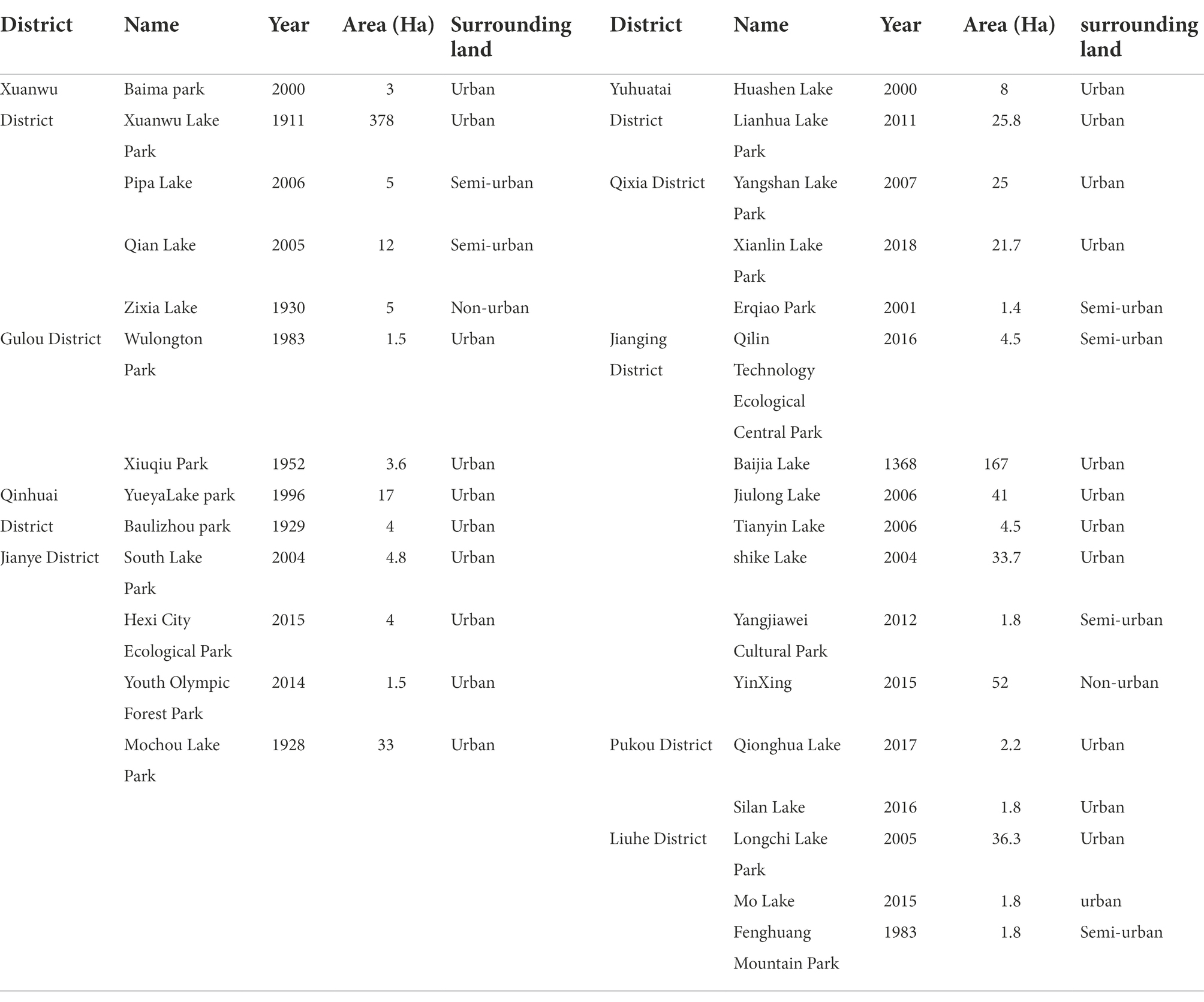
3. The current situation of the surrounding land: Considering the nature of land use around the water body, the water bodies in urban green spaces surrounded by urban land、semi-urban land and non-urban land are selected for this study to facilitate the subsequent analysis and discussion.
4. Landscape richness: The water system is a composite landscape, and the landscape elements of the water body need to be considered during object selection to facilitate the study of the landscape characteristics of the water body.
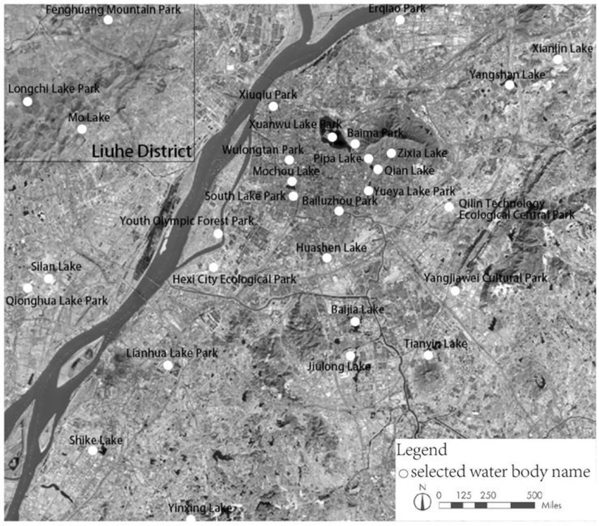
Under comprehensive screening conditions, a total of 30 water bodies were screened and located based on Landsat 8OLI_TIRS satellite remote sensing data (Figure 1), also, these 30 water bodies met the research requirements of this paper in terms of area, historicity and design degree and were reliable and complete. The research objects are classified into three categories: modern public space-type water bodies, historical and cultural water bodies, and ecological and scenic water bodies, based on the “Nanjing Landscape Journal” and the year of construction, area, and nature of the surrounding land, etc. The specific classification is shown in Table 1.
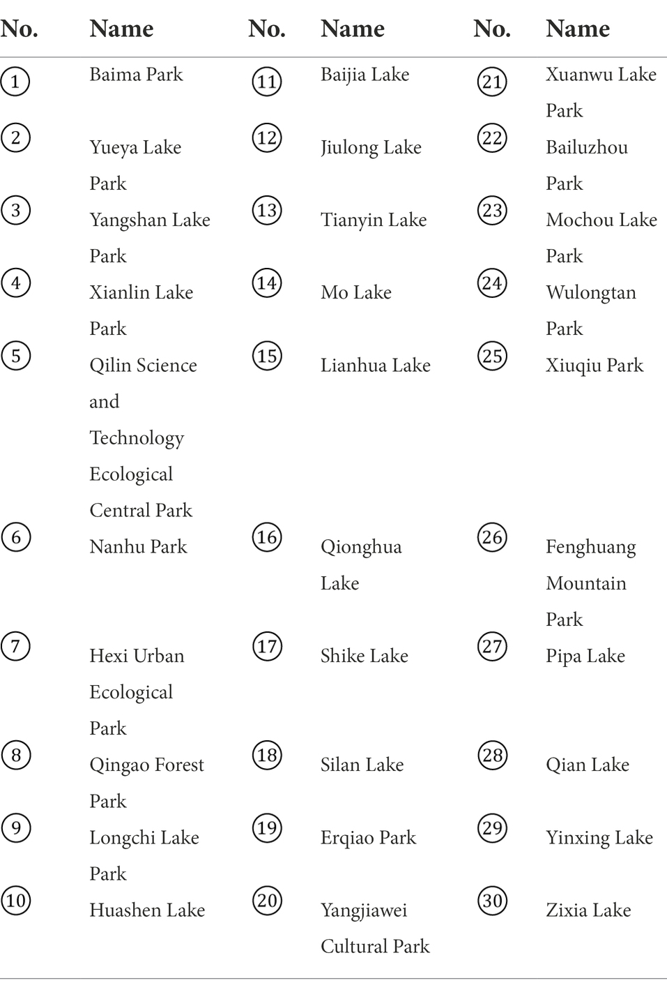
1. Modern public space-type water bodies: This type of water body includes 1 Baima Park, 2 Yueya Lake Park, 3 Yangshan Lake Park, 4 Xianlin Lake Park, 5 Qilin Science and Technology Ecological Central Park, 6 Nanhu Park, 7 Hexi Urban Ecological Park, 8 Qingao Forest Park(Youth Olympic Forest Park), 9 Longchi Lake Park, 10 Huashen Lake, 11 Baijia Lake, 12 Jiulong Lake, 13 Tianyin Lake, 14 Mo Lake, 15 Lianhua Lake, 16 Qionghua Lake, 17 Shike Lake, 18 Silan Lake, 19 Erqiao Park and 20 Yangjiawei Cultural Park as the research objects.
2. Historical and cultural water bodies: This type of water body includes 21 Xuanwu Lake Park, 22 Bailuzhou Park, 23 Mochou Lake Park, 24 Wulongtan Park, 25 Xiuqiu Park, and 26 Fenghuang Mountain Park as the research objects.
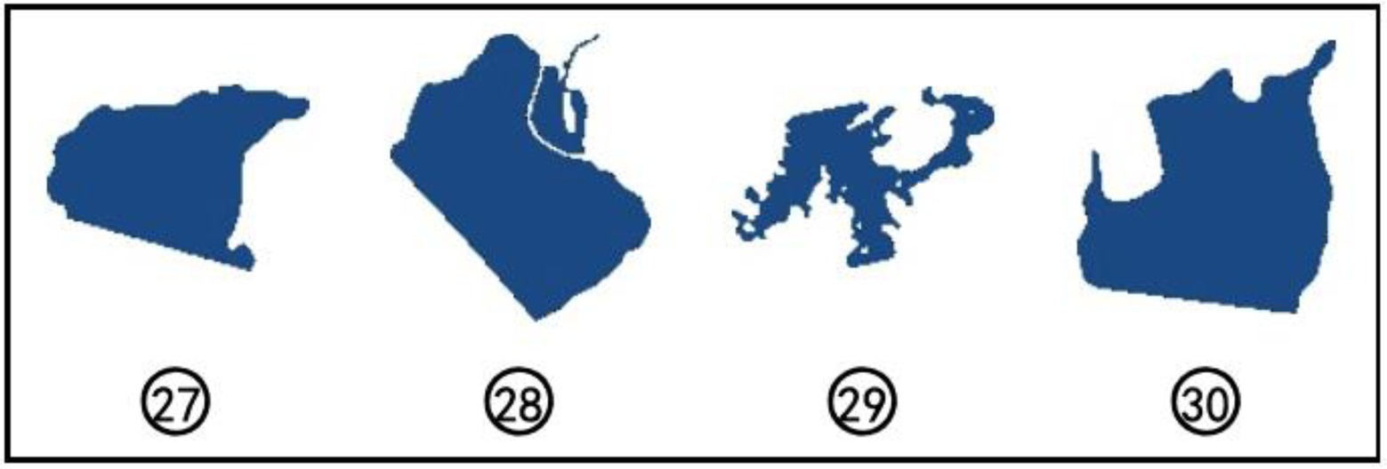
3. Ecological and scenic water bodies: This type of water body includes 27 Pipa Lake, 28 Qian Lake, 29 Yinxing Lake, and 30 Zixia Lake as the research objects.
Table 2 shows more visually the numbering correspondence of the 30 water bodies.
Data and method
Data sources
In this paper, the planar morphological data of water bodies were obtained from Landsat 8OLI_TIRS satellite remote sensing data images. At different heights, the shape and complexity of the same water body will differ, leading to errors. Thus, in this study, to ensure the accuracy of the results, the same viewpoint height of 500 meters was chosen to collect planar images of the water body (He, 2021; Zhan, 2021). When the viewpoint height is 500 m, the required accuracy of the study can be met; if the viewpoint height is higher than 500 m, the image accuracy cannot meet the requirements; if it is lower than 500 m, the viewpoint range definition cannot meet the requirements.
Research methods
This paper investigates the planar morphology of water bodies in urban green spaces based on fractal theory, there are several methods to calculate the fractal dimension, and for the convenience of mathematical calculation and empirical estimation, this paper adopts the counting box dimension for calculation. The basic method uses a square grid with continuously refined edge lengths to cover the measured figure, and the number of grids intersecting the figure and the grid are counted (Sahu and Priyadarshi, 2020).
The fractal dimension can be calculated according to equation (1), where D is the counting box dimension value, N(r) is the number of intersecting grids, and r is the length of the square network lattice side.
Because of the large statistics related to the box dimensions and the complicated operation process, fractal analysis software is needed for further research. In this paper, we use Fractalyse2.4 to calculate the fractal dimension value.
Results
The shapes of the urban green water body plane shoreline formed after geometric correction and edge enhancement based on fractal theory and ERDAS software are shown in Figures 2–4. Meanwhile, during the extraction of the water profile, the following three points were noted: (1) artificial structures with limited distribution on the water body shoreline and little influence on the water body shape, such as stacks, piers, and buildings, were ignored; (2) the planar contour shapes of artificial structures with great influence on the lake shape and the subsequent landscape design were extracted; (3) the planar shapes of existing islands and dikes in the water body were extracted.
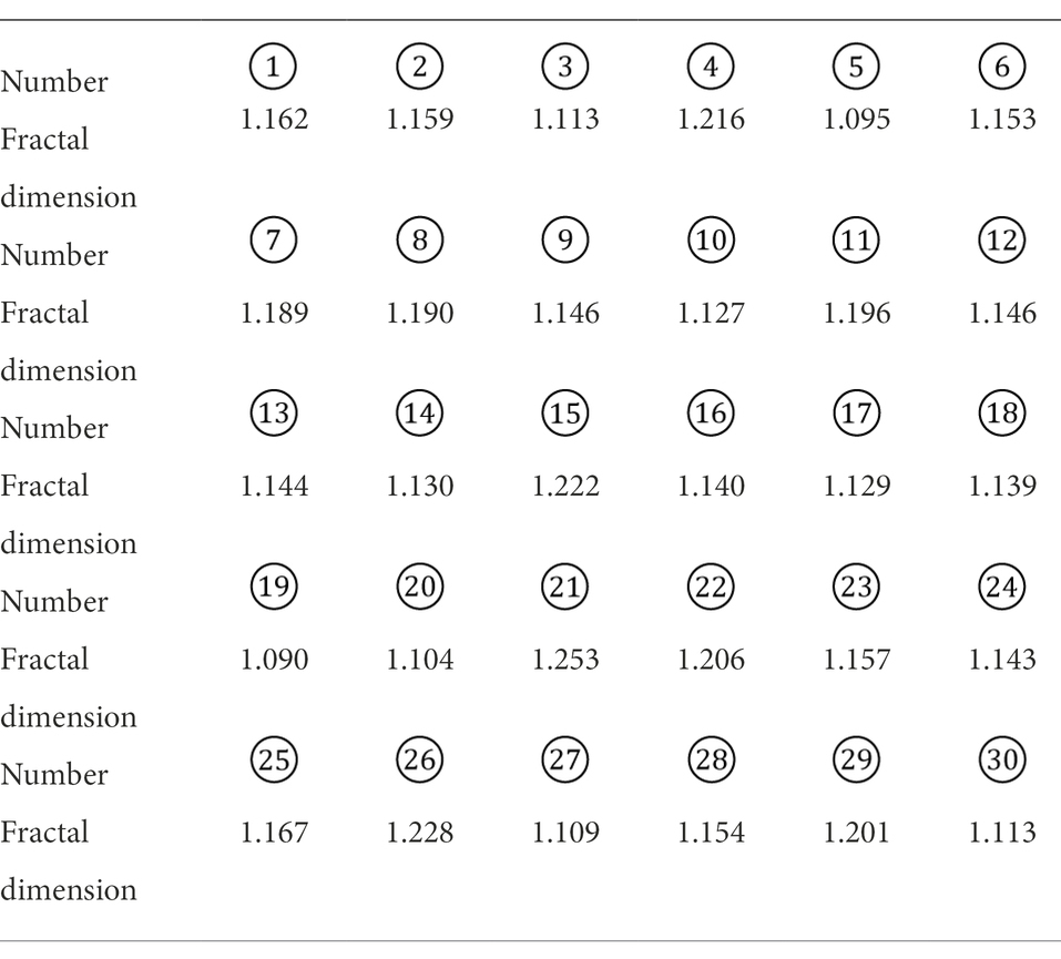
The TIFF files with the extracted water body planar shapes were imported into Fractalyse 2.4 software for calculation, and the resulting fractal dimension data are shown in Table 3.
Analysis and discussion
Is there a relationship between the planform of urban green space water bodies and the fractal dimension value?
The fractal dimension can provide an objective quantitative description of complex objects with high adaptability. In studies related to the spatial morphology of urban squares, it has been noted that when the fractal dimension value of the study object is close to 1.10, the fractal characteristics are not obvious but reflect the characteristics of a one-dimensional line or two-dimensional surface (Li and Sun, 2020).
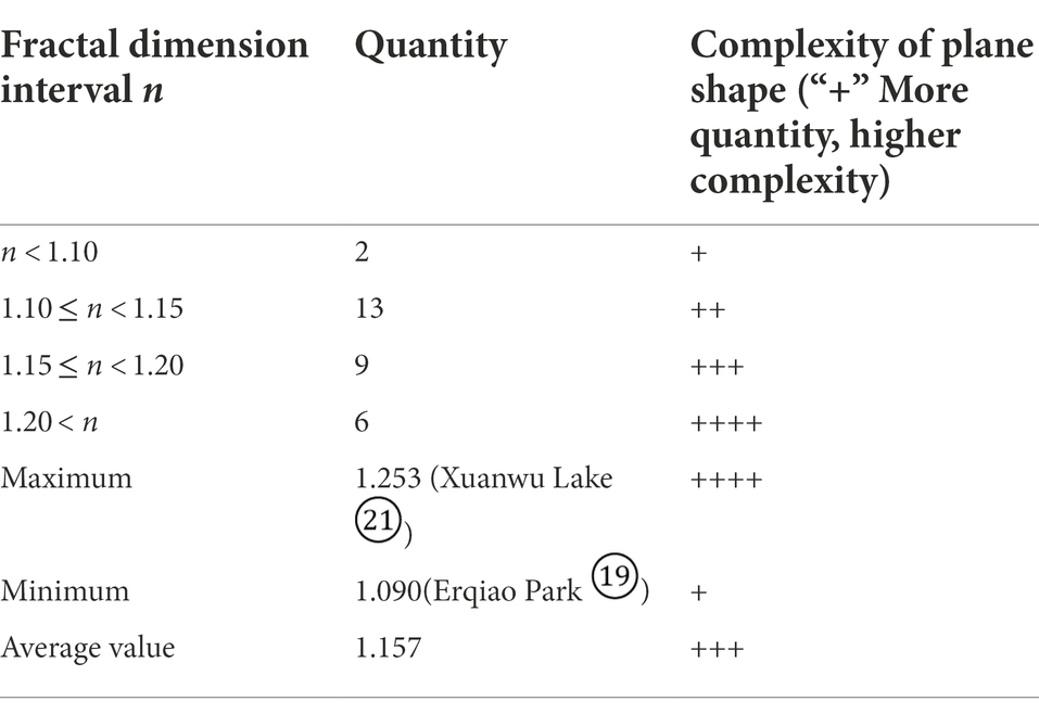
Based on the above study it can be found that, the planar morphology of urban green space water bodies is related to the fractional dimensional value. Based on the above study it can be found that the fractal dimension values of the 30 water bodies involved in this study were mainly distributed within the interval of 1.10–1.20, with an average value of 1.157. The fractal dimension values of the 30 water bodies exhibited large differences, and Xuanwu Lake Park had the maximum fractal dimension in this study, with a value of 1.253; Erqiao Park had the minimum fractal dimension, with a value of 1.090. The fractal dimension values of four water bodies, namely, Erqiao Park, Qilin Science and Technology Ecological Central Park, Yangjiawei Cultural Park and Pipa Lake, were close to or less than 1.10 (Table 4).
Is it possible to use the fractal dimension as an evaluation index of urban green space water space?
To explore whether the fractal dimension can be used as an evaluation index for urban green space water bodies, the results of the above 30 water bodies were analyzed class by class according to the classification criteria in the research object.
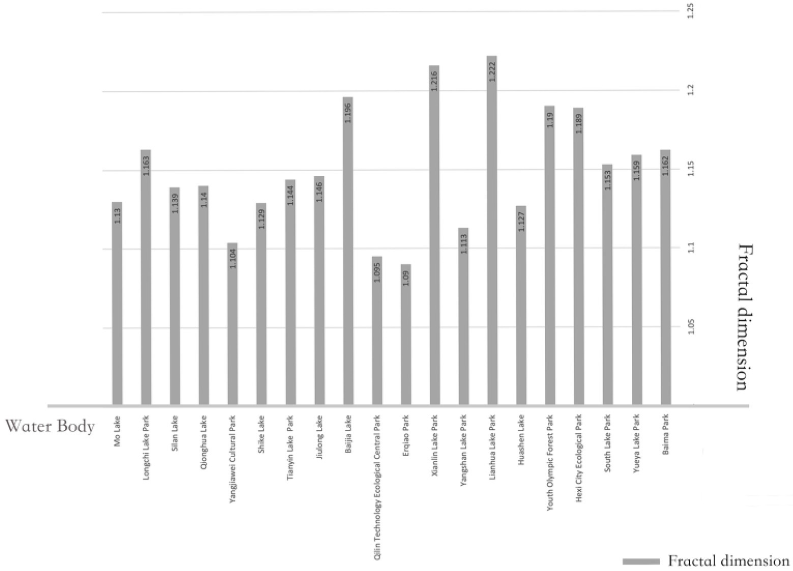
Modern public green areas mainly serve the surrounding residents, and their water bodies both provide open space and improve the urban microclimate (Wu, 2020). The fractal dimension values of the 20 modern public space-type water bodies in Nanjing (Figure 5) ranged from 1.10~1.15, and the average value was 1.150 (Table 5). The data showed that urban public space-type water bodies had relatively simple planar shapes that were characterized by low curvature of the shoreline, weak richness of the landscape, weak hydrophilicity of urban green space, and imperfect functionality of water bodies; thus, these water bodies need to be optimized.
Table 6 shows the results of fractal dimension analysis of historical and cultural water bodies. Nanjing is located in the Yangtze River Delta hinterland, which is dominated by Jiangnan culture, and has long been influenced by the gardens of Suzhou and Yangzhou. The classical gardens in the city are all in the style of Jiangnan private gardens (Wang et al., 2019), and the water body designs in these gardens focus on “adapting to local conditions” and “conforming to nature.” The design of water bodies in private gardens to the south of the Yangtze River is based on the “suitability of the place” and the “conformity to nature,” and the design of water features is cleverly combined with the topography, fully integrated with nature and artistically treated. The detailed fractal dimensions show that the fractal dimensional values of historical and cultural water bodies are all higher, with an average fractal dimensional value of 1.192, which is close to 1.20. Such water bodies are influenced by the historical and cultural factors of Nanjing, showing the advantages of a meandering shoreline, irregular water surface form, rich water landscape elements, strong landscape layers, large recreation space, high landscape aesthetics, and strong functionality.
Table 7 shows the results of fractal dimension analysis of ecological landscape water bodies. The research data showed that the average fractal dimension value of ecological landscape water bodies was 1.144, which is close to the average fractal dimension value of modern public space water bodies but much lower than that of historical and cultural water bodies. The ecological landscape water bodies studied in this paper were in urban suburbs or scenic areas and were built according to the surrounding terrain, with large water body areas and little human intervention. The average fractal dimension value was low, and there were large differences in the fractal dimension values among the four water bodies. Biwa Lake and Zixia Lake are in the scenic area of Zhongshan Mountain, and the surrounding terrain is gentle, with smooth shorelines and low fractal dimension values. Qianhu Lake is in the southwest of Zhongshan Botanical Garden, with diverse shorelines, but this lake is constrained by the Ming City Wall, with low fractal dimension values. Ginkgo Lake is in the suburban area, with an open view, rich landscape elements, high artificial development intensity, large shoreline changes, and high fractal dimension values.
The study found that the fractal dimension can be used as an index to evaluate the planar shape of water bodies in urban green spaces, and the curvature of the shoreline, the type of water body, the richness of landscape elements and the fit with the environment surrounding the water body can be quantitatively reflected by the fractal dimension.
The higher the fractal dimension value is, the better the planar form of the water bodies in urban green spaces and the higher the richness of the shoreline curvature, water body types and landscape elements. Water bodies with historical and cultural significance are influenced by the design of ancient water bodies, which have creative layouts, rich landscape elements and levels, high landscape aesthetics and strong functionality, the fractal dimension values are higher than water bodies in modern urban public spaces and ecological landscape water bodies; Due to the variability in water body functions, the ecological landscape type water bodies are less developed and have the lowest average fractal dimension value among the three water body types.
Is it representative that the number of historical and cultural water bodies and ecological and landscape water bodies in the study area is relatively small compared to modern public space water bodies?
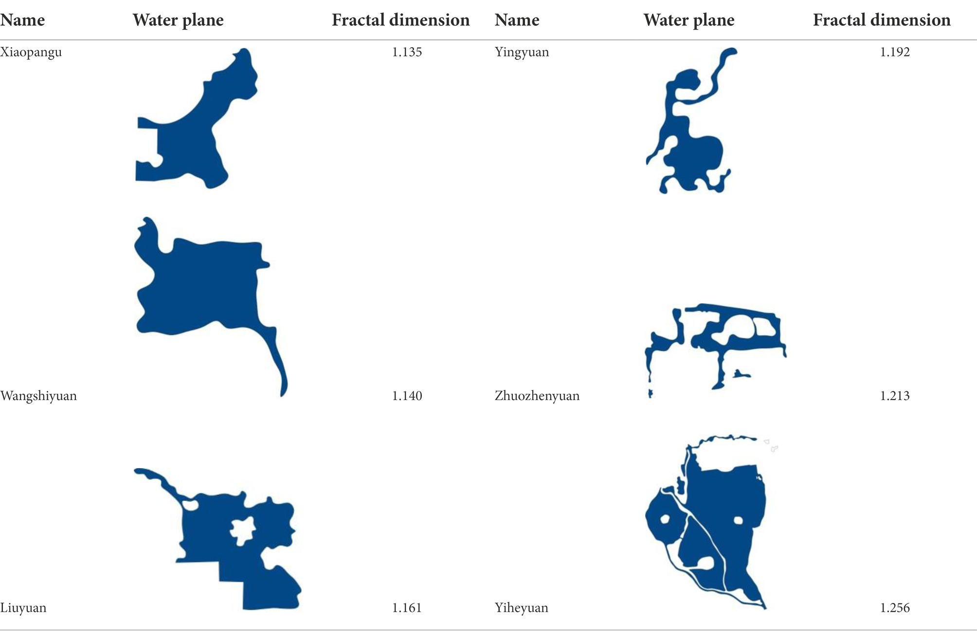
In contrast, the number of historical and cultural water bodies and ecological landscape water bodies in Nanjing is relatively small compared with the number of modern public space water bodies. In order to ensure the representativeness of the study, another seven representative historical and cultural and ecological landscape water bodies in China were selected for cross-sectional study, and the extracted planar morphology of the water bodies and their fractal dimensions are shown in Table 8.
The analysis shows that the seven selected water bodies are consistent with the results of the historical and cultural water bodies and ecological and landscape water bodies analyzed above, which indicates that the above study is representative and reliable.
What are the specific factors that affect the planar fractional dimensional value of the water body?
To investigate the specific factors affecting the fractal dimension values of water bodies, four water bodies with the highest and lowest fractal dimension values were selected for analysis and comparison in terms of shoreline curvature, richness of landscape elements, nature of surrounding land, age, etc. The four water bodies with the highest fractal dimension values were Xuanwu Lake, Fenghuang Mountain Park, Lianhua Lake Park and Xianlin Lake Park, while the four water bodies with lowest fractal dimension values were Erqiao Park, Qilin Technology Ecological Central Park, Yangjiawei Cultural Park and Pipa Lake (Table 9). The analysis shows that the factors affecting the fractal dimension value of a water plane can be summarized in the following three points.
Water body area
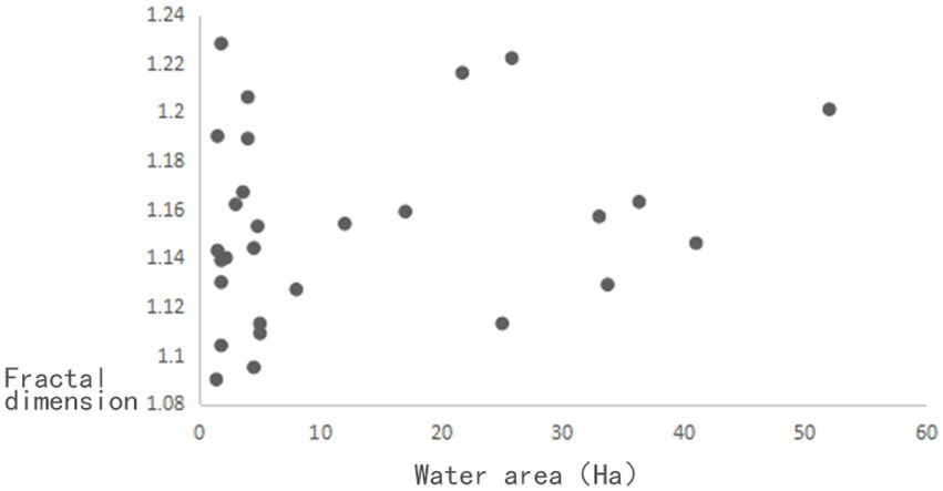
Water body area varies with internal and external factors such as time and climate, and to investigate whether this variation affects the results of the study, a scatter plot of the area of the water body and its planar morphological sub-dimensional values was plotted (Figure 6). Figure 6 shows that there was no relationship between the two, and it was difficult to fit a linear regression equation for the two sets of data.
Curvature of the waterfront
Water bodies with high shoreline curvature have good ecological and landscape benefits; in contrast, water bodies with low shoreline curvature lack both landscape aesthetics and the normal operation of ecological functions. By analyzing the eight water bodies, it was found that the four water bodies in urban green spaces with high fractal dimension values had a high degree of shoreline curvature, and the proportion of flat and straight edges did not exceed one-fifth. The overall aesthetic shapes of these water bodies were strong. The four water bodies in urban green spaces with low fractal dimension values had mainly flat and straight edges, which lack aesthetics, as the proportions of flat and straight edges were one-third in Pipa Lake, one-half in Yangjiawei Cultural Park and Qilin Technology Ecological Central Park, and one-half in Erqiao Park. One-half of the waterfront is in the park, and more than two-thirds of the waterfront is in the Erqiao Park.
Types of water bodies and landscape elements
Urban green space is composed of “points, lines and surfaces” and is a complete system containing multiple elements (Peng et al., 2016). Studies show that water bodies with low fractal dimension values contain only a single type of water form and lack landscape elements such as continents, islands, and embankments and have bridges in and around them. In contrast, water bodies with high fractal dimension values are complex and rich in landscape elements. For example, in Xuanwu Lake, which has the highest fractal dimension value in the study, there are continents and islands in the lake connected by embankments and bridges. The more landscape elements there are, the higher the landscape level and the better the water body planar form.
Restrictions of the surrounding environment
Water bodies in urban green spaces are important patches in green space and cannot exist in isolation from the surrounding environment (Liu et al., 2021). The fractal dimension values of water bodies in urban green spaces can be influenced by the surrounding environment, mainly due to the disturbance of the water body planes by human construction activities. For example, Pipa Lake is adjacent to the ancient city wall of Nanjing, and its southern shoreline is parallel to the city wall, resulting in an excessively straight shoreline and a low fractal dimension value. Conversely, the water body of Fenghuang Mountain Park is influenced by its surrounding mountains, and its shoreline is very tortuous, with a variable water body planar shape and a high fractal dimension value.
Regional economic development level
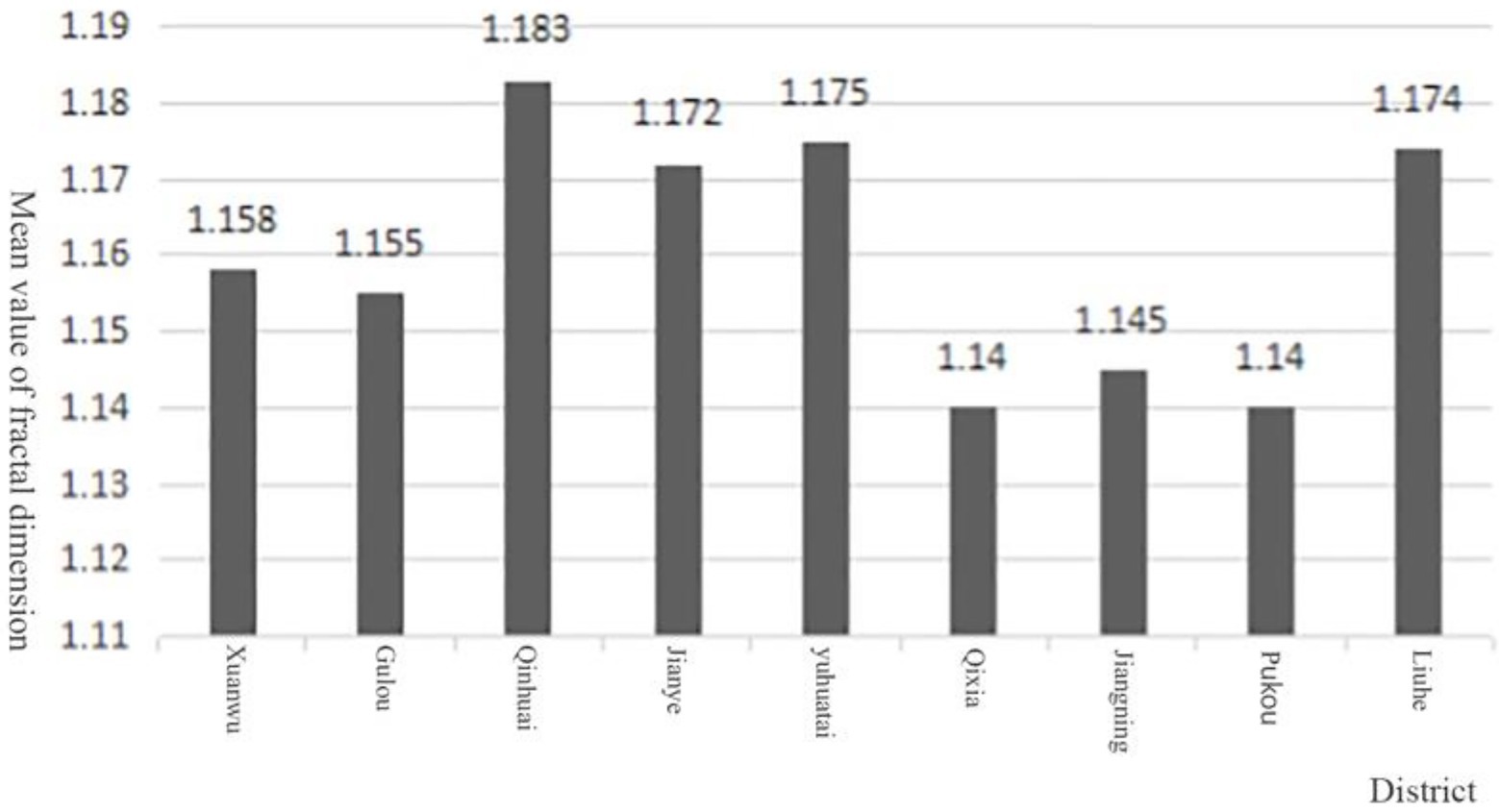
Table 1 shows that the urban green space water bodies in eight main city districts (Xuanwu District, Gulou District, Qinhuai District, Jianye District, Yuhuatai District, Qixia District, Pukou District, Jiangning District) and Lihe District were selected for this study, while Lishui District and Gaochun District, which were formerly suburban counties, were not included in the study, and Figure 7 shows the water body fractional dimensional averages within each administrative region. It is found that the mean values of urban green space water bodies in each administrative region can be divided into three zones, which are greater than 1.170, including Qinhuai District, Jianye District, Yuhuatai District and Liuhe District; between 1.150 and 1.160, including Xuanwu District and Gulou District; and less than 1.150, including Qixia District, Jiangning District and Pukou District. Relatively speaking, the better the economic development, the higher the fractal value of the area. Take Jianye District as an example, as the new urban area of Nanjing and the main site of the Youth Olympic Games, the urban construction level is also higher, the type of urban green space and water bodies in the district are more diverse, combining “point, line and surface,” and the landscape elements are richer and have higher dimensional values.
Above all, the curvature of the water body shoreline, water body type and landscape elements, the surrounding environment and the regional economic development level are four important elements affecting the fractal dimension value of urban water bodies, and the fractal dimension value is positively related to the complexity of the water body planar shape.
What is the specific impact of the fractional dimensional value on the perimeter of urban green space water bodies?
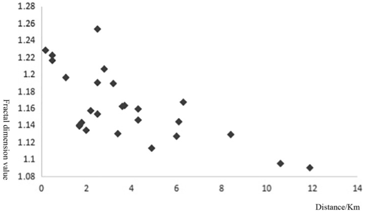
To further investigate the relationship between the fractal dimension and the surrounding environment of the water body, based on the above analysis, we used Google Earth to measure the distance between the water body of each green space and the urban regional center, the urban regional center mentioned here does not refer to the center of the administrative district in a narrow sense, but refers to the regional center of the urban group where the green space is located, and the distance between some specific urban green space water bodies and the regional center obtained from the study is shown in Table 10, and the scatter plot obtained from the data collation is shown in Figure 8.
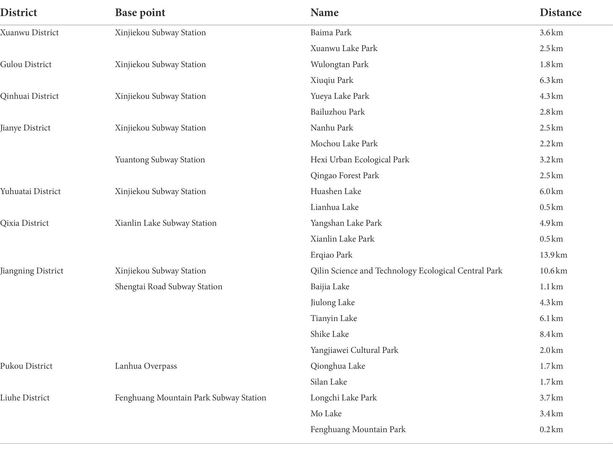
Table 10. The distance between the water body of the urban green space and the center of the region.
The scatter diagram shows that the dimensional values of water bodies in urban green areas are highly correlated with their location. The closer the water body is to the center of the city, the higher its fractal dimension value is; the closer the water body is to the edge of the city, the lower its fractal dimension value is. At the same time, based on the fractal dimension, we found that the fractal dimension is positively correlated with the surrounding property price and pedestrian activity, and the shorter the distance of the water body in the same area, the higher the property price and the higher the pedestrian activity; the longer the distance, the lower the property price and the lower the pedestrian activity.
Meanwhile, the author also hopes that the subsequent in-depth thinking can be carried out, and the subsequent study can consider linking the fractal dimension with quantitative indicators of urban ecosystem services such as captured CO2 mass or evapotranspiration, to explore whether the fractal dimension value is related to urban ecosystem service indicators.
Conclusion
Based on fractal theory, this paper investigates and calculates the fractal dimension of 30 urban green water bodies in Nanjing, and finds that (1) The fractal dimension can be used as the evaluation index of the planar form of urban green space water bodies. (2) The fractal dimension can be used as the evaluation index of urban green space water body space, and the high value of fractal dimension is positively correlated with the merit of urban green space water body plane form. (3) The curvature of water body shoreline, water body type and landscape elements, water body surrounding environment and the regional economic development level are four important elements that affect the planar fractal dimension value of urban water bodies. (4) The water body fractional dimension value is positively correlated with the house price and the amount of human activity around the water body.
Suggestions
Based on the conclusions of the above research and analysis, it is readily apparent that the plan for modern public space-type water bodies in Nanjing needs to be optimized and enhanced. At present, the average fractal dimension of modern public space-type water bodies in Nanjing is low, the water body plan is simple, and the shoreline curvature and landscape element richness are low. Nanjing is characterized by “mountain, water, city and forest.” The public urban green spaces in Nanjing need to assume the functions of rest and internal and external circulation, and water bodies are an important element to ensure the ecological functions of the landscape. However, the data in this study show that the average fractal dimension value of water bodies in modern public spaces in Nanjing is low, and there are too many hard and flat barges, which seriously affects the aesthetics and ecological benefits of water bodies and contradicts the characteristics of the city. Thus, these water bodies need to be optimized and improved.
On this basis, this paper puts forward the following suggestions on the problems of Nanjing’s urban green space water bodies.
Based on the conclusions of the above research and analysis, the following suggestions are made to address the water body problems in the urban green space of Nanjing.
1) Pay attention to the planning of water body planar form.
When planning the water bodies in urban green spaces, the shape of the planar form should be fully considered. The water design techniques of classical Chinese gardens should be used as a reference, the form and curvature of the shoreline should be fully considered, and the richness of landscape elements should be evaluated to obtain improved landscape and ecological benefits.
2) Reasonable and moderate enhancement of the water body fractal dimension value.
Research data show that different types of water bodies have differences in their reasonable range of fractal dimension values, and not all water bodies in urban green spaces should have high fractal dimension values. Because of the high ecological sensitivity of the ecological landscape water bodies in urban green areas, they should be developed in accordance with local conditions, inappropriate artificial intervention should be reduced, and more protective development should be promoted. On the premise of not destroying its ecological sensitivity, the topography can be appropriately enhanced by increasing the curvature of the shoreline and the richness of landscape elements, increasing the contact area between land and water, promoting material and energy exchange, improving biodiversity, and promoting ecological benefits to a great extent. Therefore, it is recommended that many aspects should be considered in future water body plans, according to the local conditions, to design the most consistent water body planar form.
We hope that this proposal can provide a reference for similar urban green space water body studies.
Data availability statement
The original contributions presented in the study are included in the article/Supplementary material, further inquiries can be directed to the corresponding author.
Author contributions
HOW wrote the main manuscript text and prepared figures and tables. ZC prepared Figures 4, 5 and Table 3. HNW prepared Figures 7, 8. JY provided financial support. All authors contributed to the article and approved the submitted version.
Funding
This work was supported by Advantageous Discipline Construction Project of Jiangsu Universities (Grant numbers [PAPD]) and the National Natural Science Foundation of China [grant number (31570703)].
Conflict of interest
The authors declare that the research was conducted in the absence of any commercial or financial relationships that could be construed as a potential conflict of interest.
Publisher’s note
All claims expressed in this article are solely those of the authors and do not necessarily represent those of their affiliated organizations, or those of the publisher, the editors and the reviewers. Any product that may be evaluated in this article, or claim that may be made by its manufacturer, is not guaranteed or endorsed by the publisher.
Supplementary material
The Supplementary material for this article can be found online at: https://www.frontiersin.org/articles/10.3389/fevo.2022.1038980/full#supplementary-material
References
Arlinghaus, S. L., and Arlinghaus, W. C. (1989). The fractal theory of central place geometry: a Diophantine analysis of fractal generators for arbitrary Löschian numbers. Geogr. Anal. 21, 103–121. doi: 10.1111/j.1538-4632.1989.tb00882.x
Dai, X., Zhou, Y., Ma, W., and Zhou, L. (2017). Influence of spatial variation in land-use patterns and topography on water quality of the rivers inflowing to Fuxian Lake, a large deep lake in the plateau of southwestern China. Ecol. Eng. 99, 417–428. doi: 10.1016/j.ecoleng.2016.11.011
Ding, J. (2013). Study on the morphology and waterscape characteristics of urban integrated parks in Shanghai. Shanghai Jiao Tong University.
Du, H., Cai, W., Xu, Y., Wang, Z., Wang, Y., and Cai, Y. (2017). Quantifying the cool island effects of urban green spaces using remote sensing data. Urban For. Urban Green. 27, 24–31. doi: 10.1016/j.ufug.2017.06.008
Duan, C., Zhang, J., Wang, X., Yan, Y., Hu, J., and Run, J. (2022). Forest canopy line and color analysis of landscape plants based on dimensional features. Agron. J. 12:60
He, L. (2021). Analysis of land use characteristics and influencing factors in Lingshan County based on fractal theory (master). Donghua Univ. Technol. doi: 10.27145/d.cnki.ghddc.2021.000225
Jing, Z., Jin, Z., and Chang, L. (2020). Analysis of waterscape engineering skills of classical chinese gardens. J. Landscape Res. 12, 9–14. doi: 10.16785/j.issn1943-989x.2020.3.003
Joye, Y. (2011). A review of the presence and use of fractal geometry in architectural design. Environ. Plan. B Plan. Design 38, 814–828. doi: 10.1068/b36032
Lagarias, A., and Prastacos, P. (2020). Comparing the urban form of south European cities using fractal dimensions. Environ. Plan. B Urban Analyt. City Sci. 47, 1149–1166. doi: 10.1177/2399808318820911
Li, H. (2008). A study of the fractal beauty of classical Chinese gardens Northeast Forestry University.
Li, J., and Sun, Z. (2020). Urban function orientation based on spatiotemporal differences and driving factors of urban construction land. J. Urban Plan. Dev. 146:05020011. doi: 10.1061/(ASCE)UP.1943-5444.0000587
Liao, B., and Li, L. (2022). Urban green innovation efficiency and its influential factors: the Chinese evidence. Environ. Dev. Sustain. 1–23. doi: 10.1007/s10668-022-02316-4
Liu, S., Lai, S.-Q., Liu, C., and Jiang, L. (2021). What influenced the vitality of the waterfront open space? A case study of Huangpu River in Shanghai, China. Cities 114:103197. doi: 10.1016/j.cities.2021.103197
Luan, H. (2020). Establishing the downscaling and spatiotemporal scale conversion models of NDVI based on fractal methodology, Fractal Analysis-Selected Examples IntechOpen.
Mandelbrot, B. B., and Mandelbrot, B. B. (1982). The fractal geometry of nature. WH freeman: New York.
Ning, J., Liu, J., Kuang, W., Xu, X., Zhang, S., Yan, C., et al. (2018). Spatiotemporal patterns and characteristics of land-use change in China during 2010–2015. J. Geogr. Sci. 28, 547–562. doi: 10.1007/s11442-018-1490-0
Peng, J., Xie, P., Liu, Y., and Ma, J. (2016). Urban thermal environment dynamics and associated landscape pattern factors: a case study in the Beijing metropolitan region. Remote Sens. Environ. 173, 145–155. doi: 10.1016/j.rse.2015.11.027
Risbøl, O., Langhammer, D., Schlosser Mauritsen, E., and Seitsonen, O. (2020). Employment, utilization, and development of airborne laser scanning in fenno-scandinavian archaeology—a review. Remote Sens. (Basel) 12:1411. doi: 10.3390/rs12091411
Sahu, A., and Priyadarshi, A. (2020). On the box-counting dimension of graphs of harmonic functions on the Sierpiński gasket. J. Math. Anal. Appl. 487:124036. doi: 10.1016/j.jmaa.2020.124036
Shi, L., Halik, Ü., Abliz, A., Mamat, Z., and Welp, M. (2020). Urban green space accessibility and distribution equity in an arid oasis city: Urumqi, China. Forests 11:690. doi: 10.3390/f11060690
Wang, Y., Ren, H., Dong, L., Park, H.-S., Zhang, Y., and Xu, Y. (2019). Smart solutions shape for sustainable low-carbon future: a review on smart cities and industrial parks in China. Technol. Forecast. Soc. Chang. 144, 103–117. doi: 10.1016/j.techfore.2019.04.014
Wen, C., Albert, C., and Von Haaren, C. (2020). Equality in access to urban green spaces: a case study in Hannover, Germany, with a focus on the elderly population. Urban For. Urban Green 55:126820. doi: 10.1016/j.ufug.2020.126820
Wu, L. (2020). Socio-Spatial (In)Equality of Access to Urban Green Space: A Case in Beijing. Doctoral dissertation, Harvard Graduate School of Design.
Xu, Z., and Ma, J. (2021). Research on the cultural landscape greenway model of water Network City——taking Suzhou as an example. Presented at the IOP conference series: Earth and environmental science, IOP Publishing, p. 012070.
Yang, Y., Ma, M., Zhu, X., and Ge, W. (2020). Research on spatial characteristics of metropolis development using nighttime light data: NTL based spatial characteristics of Beijing. PLoS One 15:e0242663. doi: 10.1371/journal.pone.0242663
Yang, L., Zhang, L., Li, Y., and Wu, S. (2015). Water-related ecosystem services provided by urban green space: a case study in Yixing City (China). Landsc. Urban Plan. 136, 40–51. doi: 10.1016/j.landurbplan.2014.11.016
Ye, D. (1999). Spatial effect of urban landscape lake shape and landscape design. China Garden 15, 41–43.
Zhan, M. (2021). Analysis of spatial and temporal evolution and health evaluation of key lakes in Wuhan city from 1973-2018. Master’s thesis. Wuhan University.
Zhang, G., Yao, T., Chen, W., Zheng, G., Shum, C., Yang, K., et al. (2019). Regional differences of lake evolution across China during 1960s–2015 and its natural and anthropogenic causes. Remote Sens. Environ. 221, 386–404. doi: 10.1016/j.rse.2018.11.038
Zhao, Z., Sun, Y., Wang, W., and Yang, Y. (2019). Study on the utilization and protection of water resources in the eco-tourism development of the Boluo Lake wetland nature reserve in Jilin Province. Desalin. Water Treat. 169, 114–119. doi: 10.5004/dwt.2019.24439
Zheng, B., Guo, R., Bedra, K. B., and Xiang, Y. (2022). Quantitative evaluation of urban style at street level: a case study of Hengyang County, China. Land 11:453. doi: 10.3390/land11040453
Keywords: fractal theory, water bodies, urban green spaces, planar shape, landscape design
Citation: Wu H, Chen Z, Yan J and Wu H (2022) Can urban green space water planes be quantified? A new way of thinking about landscape planning and design. Front. Ecol. Evol. 10:1038980. doi: 10.3389/fevo.2022.1038980
Edited by:
Ümüt Halik, Xinjiang University, ChinaReviewed by:
Xihui Gu, China University of Geosciences Wuhan, ChinaIlhan Özgen-Xian, Technische Universitat Braunschweig, Germany
Copyright © 2022 Wu, Chen, Yan and Wu. This is an open-access article distributed under the terms of the Creative Commons Attribution License (CC BY). The use, distribution or reproduction in other forums is permitted, provided the original author(s) and the copyright owner(s) are credited and that the original publication in this journal is cited, in accordance with accepted academic practice. No use, distribution or reproduction is permitted which does not comply with these terms.
*Correspondence: Jun Yan, Y3N0aGVzaXNAMTYzLmNvbQ==
†These authors have contributed equally to this work
‡ORCID: Haoqi Wu https://orcid.org/0000-0002-7939-4553
 Haoqi Wu
 Zhenan Chen2†