 Yue Huang1†
 Yuhao Huang
 Yile Chen
 Junxin Song
 Shuai Yang
 Liang Zheng
- 1Hangzhou Animation and Game College, Hangzhou Vocational and Technical College, Hangzhou, China
- 2Faculty of Innovation and Design, City University of Macau, Taipa, Macau, China
- 3Faculty of Humanities and Arts, Macau University of Science and Technology, Taipa, Macau, China
- 4Heritage Conservation Laboratory, Macau University of Science and Technology, Taipa, Macau, China
- 5Institute for Research on Portuguese Speaking Countries, City University of Macau, Taipa, Macau, China
- 6Center for Liangzhu Civilization Studies and Center for Cultural Heritage Studies, Hangzhou City University, Hangzhou, China
- 7Institute of Archaeology, University College London, London, United Kingdom
The “Shanshui City” is an ideal living model that has emerged recently. The spirit and concept of traditional Chinese mountain and water culture run through it, reflecting the continuity of the historical culture of harmony between humanity and nature. This study takes the ancient city of Hangzhou as a representative case. Through the translation of old maps, combined with space syntax analysis and historical satellite image analysis, this study discusses the evolution of the urban form in four periods of the ancient city of Hangzhou: the Sui Dynasty to Five Dynasties and Ten Kingdoms Period (581–979), the Song Dynasty to Ming Dynasty (960–1644), the Qing Dynasty to the Republic of China (1644–1949), and since the founding of the People’s Republic of China (1949 to present). This study reveals the following: 1) The integration of the ancient city of Hangzhou evolved from local centralization in the Sui and Tang Dynasties to spatial expansion and improved integration in the Southern Song Dynasty, followed by differentiation and weakening from the Qing Dynasty to the Republic of China and, finally, to comprehensive optimization and balance in the modern era. 2) The evolution of the morphological understanding of the ancient city of Hangzhou reflects its adaptive adjustment to social needs, natural conditions, and functional optimization in different historical periods. From the compact concentration in the Sui and Tang Dynasties to the diversified integration in the Southern Song Dynasty and then to the spatial fragmentation and optimization reconstruction in modern times, the evolution of spatial morphology in different periods reflects the interaction between the historical process and planning wisdom. 3) From the perspective of historical land function changes, the architectural functional zoning of the ancient city of Hangzhou has evolved over time, showing a trend from simple to complex and from single-to multi-function areas, reflecting the different development needs and trends of the city in terms of defense, administration, residence, commerce, and other aspects. 4) Overall, the ancient city of Hangzhou has experienced a dynamic process of building city walls, demolishing city walls, and integrating the city into the landscape, fully demonstrating the concept of a landscape city.
1 Introduction
1.1 Research background
In the academic field of urban development and planning, it is crucial to delve deeply into the evolution of cities and their construction models (Adams and Tiesdell 2012). Hangzhou, a city with a rich historical and cultural heritage, holds an important position in the history of urban development in China and worldwide. Especially in the Southern Song Dynasty (1127-1279), Hangzhou became the capital, political center, economic center, and the largest commercial city (Qian, 2015). To avoid the risks of the Qiantang River lanes, many ships with Hangzhou as their destination first arrived in Mingzhou and then transferred to the Zhejiang East Canal to Hangzhou (Huang, 2024). Mingzhou served as the outer port of Hangzhou. Hangzhou became the most important node city for trade, connecting Quanzhou and Guangzhou via the canal and its water system (Wang, C Ducruet 2013; Baihao and Sha 2016). After the Song Dynasty moved south, Hangzhou gathered a large population, forming a centripetal material flow centered on Hangzhou. Therefore, the Maritime Silk Road promoted extensive economic and cultural exchanges between China and foreign countries, and Hangzhou played a key role in this. It was an important port for trade, as well as a hub for cultural communication and integration. This unique historical position has enabled Hangzhou’s urban development to integrate multicultural elements and form a unique urban style.
As a typical mountain and water city (Shanshui City), Hangzhou’s concept and practice of mountain and water city construction have extremely high research value (Yang and Hu 2016; Fu, 2016). Hangzhou has undergone a long period of development and change since the sixth century, and it has shown unique urban features and planning characteristics in different historical periods. The mountain and water city construction model not only shapes Hangzhou’s beautiful urban landscape, but also profoundly affects the city’s functional layout, social and cultural development, and ecological environment construction. Through in-depth research on the case of Hangzhou’s mountain and water city construction, we can learn from the wisdom of the ancients how to use natural mountain and water resources in urban planning and construction, providing valuable experience for the sustainable development of modern cities and promoting the further expansion of urban development research.
1.2 The development of Hangzhou City construction
The history of Hangzhou dates back to the Qin Dynasty (BC 221 – BC 207) (Qian, 2015). It is a city located at the mouth of Hangzhou Bay. The ancient book Qiantangji records that Hangzhou relocated multiple times during the Sui Dynasty (AD 581-618), with changes in the geographical environment determining its location (Fu, 2016). During the Southern Song Dynasty (1127 -1279), Hangzhou, as the capital, achieved its zenith in the economic and cultural spheres, leading to a corresponding adjustment in its urban planning (Duan, 2020). Based on the urban form of the Southern Song Dynasty, Hangzhou has undergone two major adjustments. The late Yuan Dynasty (1271–1368) saw its eastward expansion, leading to the demolition of the southern city wall, while the early Qing Dynasty (1644–1912) saw the construction of the Qiying (Manchu tribe), encircled by the inner-city wall (Fu, 2016; Wang, 1900). Until the 20th century, Hangzhou’s urban form remained unchanged. The shape of the city did not strictly follow the quadrilateral layout of the ancient city but bulged eastward, consistent with the natural coastline of the West Lake and Qiantang River.
Overall, the spatial structure of Hangzhou’s old maps reveals four periods of evolution in the development analysis and research of the city’s spatial form (Feng and Zhou 2005).
(1) Point-like urban form. In the ninth year of Kaihuang (589), during the Sui Dynasty, Emperor Wen unified China. He changed the name of Qiantang to Hangzhou, which marked the beginning of Hangzhou (Wang, 1900; Peterek et al., 2021). According to the Sui ShuGeographical Records, in the 11th year of Kaihuang (591), during the Sui Dynasty, Minister Yang Su presided over the construction of Hangzhou City, and the country established its basic model (Wang, 1900; Lam, 2017). This was the earliest recorded building in Hangzhou City. The north had residents and markets, while the south was at Phoenix Mountain. The circumference of the city was measured at 36 li, or 90 steps. The west side of the city was near the east coast of West Lake. Hua Xin built a pond to serve as the city’s foundation. The city’s boundaries extended to what is today the Wulin Gate. The ancient city of Hangzhou was characterized by the presence of Wushan outside the city, Yunju Mountain, and Wansongling within the city, as well as other gates such as Salt Bridge, Phoenix, and Qiantang (Duan, 2020). The city underwent three expansions during the Five Dynasties and Ten Kingdoms period. The area to the south extended to the foot of Qinwang Mountain and the Liuhe Pagoda, and the north extended outside of the current Wulin Gate to form Luocheng (Fu et al., 2019a). Later, as the royal city of Wuyue Kingdom, the city expanded in size, and West Lake became the symbol of Hangzhou. Emperor Daizong of the Tang Dynasty implemented water conservation projects during his reign. The governor, Li Mi, dug six wells from the northwest West Lake to solve the drinking water needs of the residents (Du and Koenig 2012). People have used the West Lake water extraction project for over a millennium.
(2) Linear expansion of the urban form. In the eighth year of Shaoxing in the Southern Song Dynasty, Emperor Gaozong of Song, Zhao Gou, established Hangzhou as the capital of the Lin’an Prefecture (Caiyun, 2023). Water systems crisscrossed Lin’an city and its surrounding areas. The main rivers included the Maoshan River, Yanqiao Canal, Shihe River, Qinghu River, and so on. The water source came from West Lake and Qiantang River. The city expanded linearly with the water system’s structure. In the Ming Dynasty, the city wall of Hangzhou followed the old system at the end of the Yuan Dynasty (Thornton, 1996). The system of city gates underwent a change, with a total of 10 gates. The main city gates were Fengshan Gate, Wulin Gate, Yongjin Gate, and so on.
(3) Belt-like expansion of the urban form. The northwest corner of Hangzhou City established the Manchu garrison (Manchu City) during the Qing Dynasty and the Republic of China (1912–1949). The city housed the Eight Banners Army and their families. In the second year of the Republic of China, the city began to demolish the city wall and build roads to promote the urbanization process. At this time, the city exhibited characteristics of belt-like development.
(4) Planarly expanded urban form. The Revolution of 1911 abolished Hangzhou Prefecture, merged Qiantang and Renhe counties, and renamed this area Hangzhou County, maintaining its status as the provincial capital. They demolished the Qiying city wall and built markets, parks, and roads. In 1927, Hangzhou was established. The West Lake Scenic Area underwent renovations in 1979 (Fu and Jin 2020). From 2001 to 2017, Hangzhou successively abolished Xiaoshan, Yuhang, Fuyang, and Lin’an as cities and established them as districts. The urban area of Hangzhou expanded to 8,000 km2, and the total area of the city reached 16,596 km2 (Wang et al., 2022; Peterek et al., 2021).
1.3 Problem statement and objectives
Studying the evolution of Hangzhou’s spatial morphology reveals that, as a renowned historical and cultural city in China, the spatial morphology of Hangzhou’s old city not only preserves its rich historical and cultural heritage but also bears witness to urban development and social changes. Therefore, studying the evolution of Hangzhou’s old city’s spatial morphology is of enormous significance for understanding the historical context of urban development and guiding future urban planning and protection work. This study aimed to analyze this using the theoretical tool of space syntax, explore the social, economic, and cultural motivations behind it, and predict possible future development trends. The researchers mainly explored three aspects of the problem: 1) From the Qin Dynasty to the present, how did Hangzhou evolve from a city in the sea to a riverside city? 2) How did Hangzhou’s old city move through four stages of development, from its heyday to its decline and then to economic prosperity? 3) How can we understand the spatial evolution law of China’s traditional mountain and water city and the heritage protection planning of old cities and old neighborhoods in the process of urban modernization? The methods of this study can be extended to other cities, and its experience in rational planning, policy support and cultural protection is applicable to the development and protection of historic cities around the world.
2 Literature review
2.1 Shan-shui cities theory as an analytical paradigm for the evolution of ancient cities
A “Shanshui City” is an ideal living model that has emerged recently. It aims to build cities in natural mountains and rivers, let natural mountains and rivers blend with urban life, and integrate urban buildings with the natural mountains and rivers. The concept of a Shanshui City originates from combining traditional Chinese Shanshui culture with modern urban construction. Following the initial mention of the concept of a Shanshui City in a letter by Qian Xuesen and Wu Liangyong in 1900, scholars gradually developed a theoretical framework for a Shanshui City that incorporated Chinese characteristics, drawing from the ancient Chinese Shanshui philosophy (Rodenbiker, 2013; Rodenbiker, 2017). The concept of a “Shanshui City” describes people’s ideal living environment and is the overall guideline for Chinese cities to maintain a healthy development direction. It emphasizes the harmonious coexistence between humanity and nature, respects natural landforms and ecosystems, and realizes the organic integration of cities and natural environments through urban planning and garden design. This research is carried out in three directions: ideological research, theoretical systems, and practical cases. Figure 1 shows typical Chinese Shanshui cities: Hangzhou, Zhaoqing, Huizhou, and Heyuan.
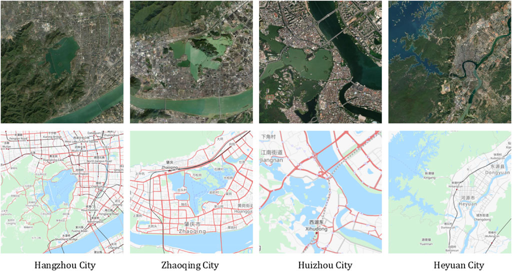
Figure 1. Typical Chinese Shan-shui cities: Hangzhou, Zhaoqing, Huizhou, and Heyuan (Image source: drawn by the author; the base map comes from OpenStreetMap and Esri, USGS World Imagery).
Under the premise of intensified urbanization in China, scholar Wu Yujiang analyzed the concept of a Shanshui City (Wu Yujiang, 2010). In addition, scholars Wu Renwei, Fang Maoqing, and Fu Liming systematically explained the origin and development of the concept of a Shanshui City and examined its sustainable practices (Wu Renwei and Fu 2009; Fang Maoqing, 2009; Fu Liming, 2005). Wang Duo and others studied the philosophical concept of a Shanshui City (Wang Duo and Wang Shihong, 2006). Meng Zhaozhen believed that a Shanshui City is the ultimate goal of urban construction and explored the necessity of creating Shanshui Cities (Meng Zhaozhen, 2012). Bao Shixing’s specific classification of a Shanshui City, when combined with existing urban and landscape planning and design tools, enhanced the knowledge system (Bao Shixing, 2005). Yan Jinbo’s research focused on the specific strategies of a Shanshui City in the construction of human settlement environments, such as urban greenway systems and three-dimensional landscape architecture that can effectively fit within a Shanshui City (Yan Jinbo, 2020); Liu Wei and others summarized the construction methods of Shanshui Cities in ancient Suzhou and Hangzhou (Liu Wei and Li Xiong, 2018).
In recent years, with the advancement of ecological civilization construction, many cities in China have begun to apply the concept of a Shanshui City to practice. Planning and design prioritize the preservation of the natural landscape pattern, the integrity of the water system and ecological corridors, and integrating elements such as green space and wetland parks (Salviano et al., 2021; Xiao et al., 2020). An important direction of Shanshui City research is the ecological restoration of damaged natural environments. This research mainly focuses on water resources management, pollution control, river restoration, and especially how to balance the contradiction between economic development and ecological protection in the context of intensified urbanization. It has proposed the concept of ecological corridors, the protection of landscape patterns, and the increase in urban green space to improve the quality of the urban ecological environment. A Shanshui City focuses on protecting the natural environment and emphasizes the inheritance and promotion of urban culture (Liu, 2024). Researchers have analyzed the manifestations of traditional landscape culture in contemporary cities and explored how to strengthen the cultural identity and historical continuity of cities through landscape design. Research in this field also includes to enhance the image of a Shanshui City through tourism development, attracting more tourists who pay attention to nature and culture. Cities such as Hangzhou, Guilin, and Suzhou are regarded as models of Shanshui City practice, especially regarding ecological restoration and landscape protection.
2.2 Analytical methods of ancient city evolution
Recent years have yielded relatively rich research results from analyses of the evolution of ancient cities. From the perspective of time, field investigation and historical document research are more commonly used methods, such as conducting field surveys at the site of an ancient city; observing the geographical environment, urban layout, architectural style, relics, and other aspects of an ancient city; and having an intuitive understanding of the current situation of an ancient city (Case, 1991). Simultaneously, by acquiring numerous historical documents about an ancient city, including local chronicles, historical records, literati notes, and inscriptions, we can discern the development context and evolution process of that ancient city. For example, according to the records of the ancient book Qiantang Ji, Hangzhou moved many times during the Sui Dynasty, and the site was determined due to changes in the geographical environment. Basic analysis plays an important role in helping researchers understand the important stages and events of the origin, construction, development, rise, and fall of an ancient city.
Space syntax and GIS technical analysis are more commonly used from the spatial measurement. In the 1970s, Professor Bill Hillier (1937–2019) proposed space syntax, which is a theoretical tool for in-depth research on the relationship between space and human cognition, architecture, and society (Hillier et al., 1976; Yamu and Garau 2021). It helps researchers understand the interaction between the structure and function of urban spaces and consciously intervene through planning and design to optimize and promote their development. This theory and method study the relationship between spatial organization and human society by quantitatively describing the structure of human settlement space, which includes buildings, settlements, cities, and even landscapes (Van Nes, 2014). It can quantify the spatial performance inside an ancient city; analyze the street layout, architectural spatial relationship, traffic flow lines, and other aspects of an ancient city; investigate existing problems; and predict development trends. Through analyzing the parameter values of axis integration, integration core, and intelligence, it is possible to summarize the characteristics of the development and evolution of the ancient city form and judge the direction of urban space expansion. Scholar Meng Leilei used space syntax to compare the evolution of urban space and urban planning in Beijing and Tokyo and compared and analyzed the phenomenon of Beijing’s rail transit lagging behind the evolution of urban space (Meng Leilei, 2022).
In the past, scholars have evaluated and analyzed the development of modern cities by focusing on the optimization of urban scale, urban systems, and urban policies (Richardson, 1972); strategic (spatial) planning (Albrechts, 2004); 15-min cities (Pozoukidou et al., 2021); the design and urban planning of future cities (Saaty et al., 2017); and the optimal city size (Capello et al., 2000). These research topics are very important components of urban development and evolution and are related to the growth of urban spatial structure and the direction of future human settlement environment construction. In addition, the use of GIS technology to collect, manage, analyze, and visualize geographic spatial data has become one of the important means of analyzing the evolution of ancient cities in recent years (Burghardt et al., 2024). The topography, building distribution, street network, historical relics, and other information of an ancient city can be digitized to establish a geographic information system database of the city. Scientist Wu Zhendong conducted a visual study on the architectural heritage space of the old city of Quanzhou (Wu Zhendong, 2018). He improved the main technical features of full centrality, vertical perspective, high-density grid points, and time–space relationship analysis using 3D GIS spatial feature analysis. He also created a sub-method for analysis. Zhang Wei and others digitally translated a city map through the ArcGIS 10.4 platform and obtained the interpreted image samples presented in a modern mapping method. We summarized the traditional city construction experience of Yaozhou Ancient City from three aspects: mountain and water city construction, urban humanistic space planning, and landscape system construction, based on the translated images. This was a reference and inspiration for a high-quality, more livable, and distinctive urban construction of contemporary Yaozhou (Zhang et al., 2024). Therefore, scholars can analyze the spatial pattern, geographical environment, and transportation network of an ancient city using the spatial analysis function of GIS. This allows them to study the evolution of an ancient city, the relationship between various elements, and the changes in an ancient city’s space over different historical periods.
3 Materials and methods
3.1 Geographical scope of the study: Hangzhou City
Hangzhou is situated on China’s southeast coast and in the northern part of Zhejiang Province (Figures 2a–c). It is located on the southern bank of the Yangtze River Delta, the lower reaches of the Qiantang River Basin, and the southern end of the Beijing–Hangzhou Grand Canal. The terrain is complex and diverse. It was a famous county in the Sui and Tang Dynasties (AD 581–907), the capital of Wuyue Kingdom (吳越國), the capital of the Southern Song Dynasty (AD 1127–1279), and the capital of Zhejiang Province during the Yuan Dynasty (AD 1271–1368). It has a profound historical and cultural heritage. Today, it is also the political, economic, cultural, scientific, educational, and financial center and transportation hub of Zhejiang Province, a national megacity, the central city of the southern wing of the Yangtze River Delta, and the core city of the Hangzhou Metropolitan Area. The main representative unique cultures include Liangzhu culture, silk culture, tea culture, traditional Chinese medicine culture, calligraphy, painting, and seal carving art, as well as many stories and legends handed down, modern operas, and major contemporary festivals. These cultures significantly influence Hangzhou’s transformation into a renowned historical and cultural city (Figures 2d–h).
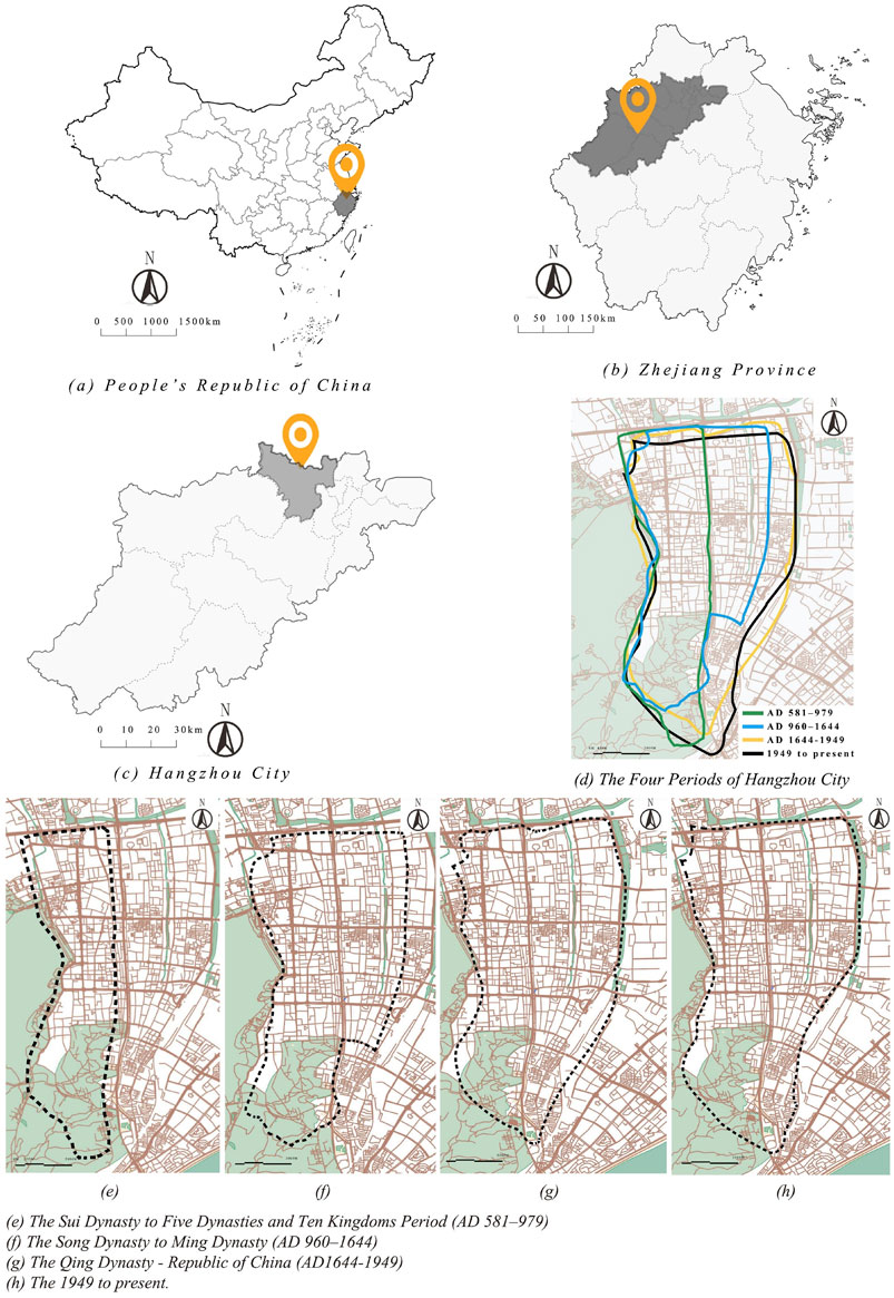
Figure 2. Location analysis of Hangzhou. (a) People’s Republic of China; (b) Zhejiang Province; (c) Hangzhou City; (d) the Four Periods of Hangzhou City; (e) the Sui Dynasty to Five Dynasties and Ten Kingdoms Period (581–979); (f) the Song Dynasty to Ming Dynasty (960–1644); (g) the Qing Dynasty to the Republic of China (1644-1949); (h) the 1949 to present (Image source: drawn by the author).
Since the Sui Dynasty (581–618), the area from the west bank of the lower reaches of the Qiantang River to West Lake has become the seat of administrative districts above the county level (Hangzhou, Yuhang County, Lin’an Prefecture, Hangzhou Road, Hangzhou Prefecture). Successive walls were built for defense around the state, county, and prefecture, including the Hangzhou city wall, also known as the state city and prefecture city. Since the Wuyue Kingdom, the Hangzhou city wall has defined the city’s development space. Today, Hangzhou’s main urban area’s city center is roughly within the scope of the ancient city wall. The early 20th century saw the demolishment of the Hangzhou city wall, leaving only the Fengshan Water Gate (鳳山水門) and a few relics. In the 1980s, dredging of the Middle River and East River protected the Fengshan Water Gate and repaired a small portion of the surrounding city wall atop the water gate. In addition, the Qingchun Gate (慶春門), the city tower, and the city wall were rebuilt in 2008 and opened as the Hangzhou Ancient City Wall Exhibition Hall. In 2013 and 2014, it became a national key cultural relic protection unit and a world heritage site as part of the Grand Canal. Archaeological excavations took place in 2008 after the discovery of the ruins of Qiantang Gate from the Southern Song Dynasty in the Liu Park near West Lake. Following its safeguarding, the public gained access to it. In 2011, the Qiantang Gate (錢塘門) ruins became a world heritage site as part of the West Lake Cultural Landscape of Hangzhou.
3.2 Methodology
Based on the DXF file of the ancient city digital map, this study used Depthmap software to generate an axis map to quantify the intelligence and connectivity. The global integration and choice were calculated based on the road network, and the analysis radius was set to R3, R7, R11, and the globe. This study utilized space syntax to calculate indicators such as integration and choice, revealing the connectivity and centrality of the city’s internal space. It also analyzed the role of the road network in the ancient city of Hangzhou across various historical periods and further revealed the evolution of urban functions and spatial structures.
Integration represents the degree of agglomeration and dispersion between the spaces of the Hangzhou ancient city road network structure (axis network nodes), including global integration and local integration. The integration reflects the centrality and aggregation of the internal structure of the settlement in the overall settlement structure. The higher the integration value, the better the accessibility of the space and the more reasonable the spatial layout. Choice denotes the potential for other shortest paths to traverse a specific axis in the axis space, thereby attracting traffic. This can help reveal the axis distribution structure of important road networks in the ancient city of Hangzhou. Intelligibility refers to the degree to which information gathered from a local space can effectively guide space users in understanding global space information. An axis system with low intelligibility will mislead space users about the position of this space in the overall system.
Furthermore, the researchers conducted supervised classification using old map data and historical satellite images (KeyHole and Google Earth), defined and extracted five types of functional land (military, residential, commercial, religious/public, green space, and water), and calculated the area change rate (the sixth to the twenty-first). The maximum likelihood classification method (ArcGIS) was used to extract land use data for each period, and the Kappa coefficient was verified to be ≥ 0.85; the Shannon’s diversity index formula is as follows:
In Formula 1,
3.3 Data preprocessing and map digitization
Old maps show the relationship between the urban form and geographical environment in a specific historical period, reflecting people’s activities and the spatial structure of the city at that time (Oliveira, 2019). We can divide the rich historical information these maps contain into two categories: direct information and indirect information. The city’s existing historical relics serve as direct sources of information, serving as crucial reference materials during the translation process. Images, text materials, and folk legends form the basis of indirect information, which planners and designers implement in physical space. The process known as old map translation involves extracting, classifying, locating, and revising information from old maps. This information is then represented on the current topographic map using spatial elements, resulting in a measurable digital representation of history. This method has higher accuracy than ordinary speculative old maps. First, this study drew old maps of Hangzhou City from four different periods into CAD data and ensured a reasonable balance of distance relationships on the map, including detailed steps such as old map translation, scale adjustment, reference alignment content, conversion of weights and measures, tracing of land and water routes, and correction.
(1) Preparation and map analysis. We imported four images from four different periods into CAD software. The researchers carefully analyzed each map and identified its main elements, including natural and artificial features such as city walls, city gates, streets, water networks, and mountains. They also observed that these old maps may differ in their drawing methods, scales, and styles, necessitating prompt adjustments.
(2) Setting the reference points and scale. We determined the reference points of each map to ensure accurate splicing together. The reference points can be characteristic points such as city gates, river intersections, mountains, or corners of city walls. We selected several reference points to ensure accuracy. Based on known modern surveying and mapping data or historical records, we selected several main streets or the actual length of the original city walls to determine the scale of each map. The scale is the key to ensuring that the proportions of streets and water networks are reasonable when drawing. In addition, the alignment of reference content requires the alignment of landmark features, latitude and longitude coordinates, road and street networks, border lines or administrative divisions, and cultural relics and archaeological sites. The map translation or spatial analysis process uses reference alignment, also known as reference alignment or benchmark alignment, to ensure that historical information or different data sources can accurately match the same geographic framework or benchmark location. This process is particularly important for the translation of old maps because they often have problems, such as inconsistent scale, inaccurate orientation, or missing content due to mapping technology, terrain changes, and other reasons. We corrected these differences to make the translated map more consistent with modern terrain by coordinating the reference content.
(3) Image correction and calibration. After importing the image, we used the correction tools in CAD to rotate, stretch, and scale it to align the map with the appropriate coordinate system. In particular, we aligned the reference point with the determined geographic coordinates or other reference points to facilitate a subsequent street drawing.
(4) Preliminary drawing of streets. We used the polyline tool in CAD to draw the center line according to the direction of the street on the old map. We drew only the street’s direction first, as the old map might not provide clear information on its width.
(5) Street proportion adjustment and width processing. Based on historical data, we determined the conventional width and size standards of specific streets, lanes, alleys, temples, mansions, and waterside canals. At the same time, we compared them with modern urban streets and lanes to estimate the widths of different road axes.
(6) Balancing the distance relationships on the map. During the drawing process, we paid attention to the possible scale distortion in the old map, especially the drawing style in old Chinese maps, which may cause the length and direction of streets to be inconsistent with modern ones. We referred to modern surveying and mapping data and appropriately stretched or compressed specific areas in the map to ensure that the distances between major landmark buildings met modern measurement standards. While adjusting the scale and distance is necessary, preserving the historical authenticity of the old map to the greatest extent possible is crucial. For instance, we adjusted the scale locally in areas with distortion without destroying the overall structure.
(7) Proofreading and correction. We compared the modern city’s geographical road network information (Open Street Map) to determine whether the drawn streets, water systems, buildings, and so on, were consistent with the modern map. We made the necessary adjustments based on the actual situation to ensure that the proportions of all elements were reasonable and consistent with the historical background. When processing different maps, we checked their border alignment, especially the street extension. Finally, we adjusted the map docking through the reference point to ensure no apparent misalignment between different maps.
3.4 Data sources
The data sources for this study were as follows: 1) Ancient city map information data. The researchers collected and analyzed historical documents and local chronicles related to the ancient city of Hangzhou (see Tables 1, 2). The Hangzhou Prefecture Chronicle from the Ming Dynasty, the 17 volumes of the Chun’an County Chronicle from the Jiajing period, and the Qiantang County Chronicle from the Wanli period serve as examples. These documents and maps provided information on the layout, block structure, distribution of important buildings, river network, location of city gates, city walls, and so on, of the ancient city of Hangzhou in different historical periods. 2) Data on the nature of land use in the ancient city of Hangzhou. The Hangzhou Bureau of Planning and Natural Resources (http://ghzy.hangzhou.gov.cn/col/col1228962776/index.html) provided the historical master plan drawings from which we extracted the data. For example, the master plan revision completed in 1957, the Hangzhou City Planning Map in 1959, the Hangzhou City Planning Map in August 1964, the Hangzhou Current Situation Map in October 1981 by the Hangzhou Planning Bureau, the Hangzhou City Planning and Design Institute’s Supplementary Map of the Hangzhou City Master Plan in April 1992, the Hangzhou Current Situation Map (1995), and the Hangzhou City Land Use Master Plan (2006–2020) attached to the central urban area land use master plan map all have clearly drawn and recorded land use attributes (see Table 2). 3) Historical satellite image data. The primary sources were the US KeyHole satellite image data and the current Google Maps satellite image data. The KeyHole satellite is a space spy reconnaissance satellite that the United States began to use in the 1960s. Since 1991, the US government has successively declassified data products from multiple satellite models, including approximately 930,000 photos of the earth’s topography taken by the KeyHole satellite between 1960 and 1980. These photos reveal numerous images of China, encompassing the entirety of the country’s territory. These satellite photos are the first landform images taken by humans on Earth. The photography technology at the time limited the use of an optical lens return camera, resulting in primarily black and white image data. The highest resolution can reach 0.6 m, and most areas can reach between 1.8 and 2.7 m, equivalent to the current 16-level Google satellite map. These photos play an important role in urban planning and determining the past landform boundaries of cities. 4) On-site exploration and site survey. Archaeological excavation reports and site survey data from the Hangzhou area provided information on the distribution and evolution of physical spaces such as buildings, streets, and city walls within the ancient city.
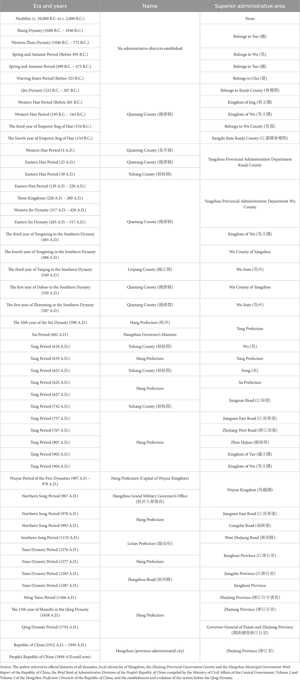
Table 1. Administrative divisions for the construction of Hangzhou City.
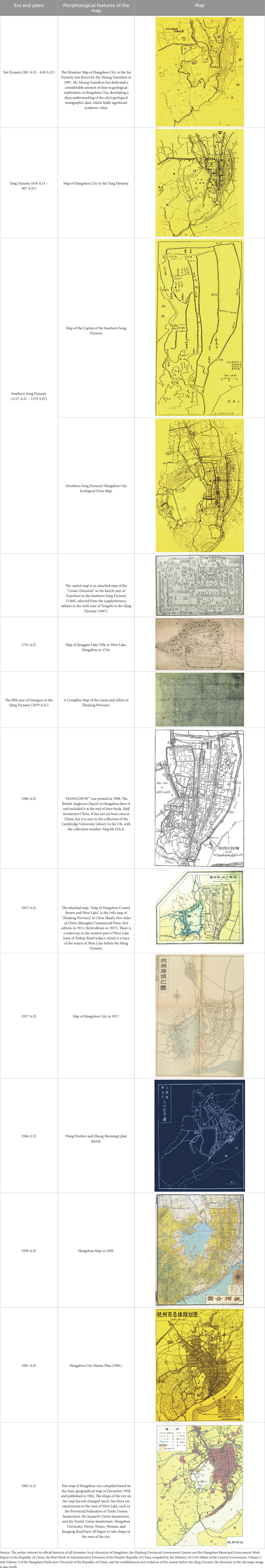
Table 2. Key maps and nodes of urban form evolution.
4 Results: Hangzhou’s evolution process and change pattern
4.1 Four periods of ancient city morphology
The spatial morphology of the ancient city of Hangzhou has moved through four important periods in its long-term development, each reflecting specific social, political, economic, and environmental influences. These stages show the interaction between urban planning, physical geography, and human activities. This study divided the four periods into the following categories:
(1) Sui Dynasty to Five Dynasties and Ten Kingdoms Period (AD 581–979): Initial formation and stable pattern. Especially in the Sui Dynasty, Hangzhou (then called Qiantang) completed the initial construction of its urban form, marked by establishing the Hangzhou government. The city had the geographical advantage of being close to the West Lake and the Qiantang River as the core, forming a point-like distribution pattern. Phoenix Mountain was the center, dividing the city into residential and commercial areas. During the Five Dynasties and Ten Kingdoms period, the city’s north–south expansion led to an expansion to the south of Qinwang Mountain and Liuhe Pagoda, and when combined with defensive and water conservancy facilities, the urban pattern gradually stabilized.
(2) Song Dynasty to Ming Dynasty (AD 960–1644): Linear expansion based on water systems. The establishment of the capital of the Southern Song Dynasty in Lin’an (now Hangzhou) marked the peak of urban development. With the improvement in its political and economic status, the urban space showed the characteristics of linear expansion along the complex water system structure (such as the Maoshan River (茆山河), Qinghu River, etc.). Hangzhou in the Southern Song Dynasty focused on the integration of natural water systems and connected the West Lake with the Qiantang River, making it not only a core area for residence and trade but also showing the profound influence of the concept of a “Shanshui City” on urban planning.
(3) Qing Dynasty to the Republic of China (1644–1949): the transitional period of belt expansion. During the Qing Dynasty, Manchu City (where the Eight Banners Army was stationed) was established in the northwest of Hangzhou, and the city gradually expanded into a strip. In the early years of the Republic of China, with the demolition of the city walls and the advancement of road construction, Hangzhou’s urbanization process accelerated significantly. Urban expansion during this period focused more on connectivity, while retaining the core of the ancient city to some extent.
(4) From the founding of the People’s Republic of China (1949 to present), there has been modernization and expansion. After the founding of the People’s Republic of China, Hangzhou’s spatial form entered a stage of rapid development. With the complete demolition of the city walls and the incorporation of surrounding areas such as Xiaoshan and Yuhang, the urban space has rapidly expanded in a flat manner. While strengthening ecological protection and cultural heritage, urban planning has also focused on constructing modern infrastructure. For example, projects such as the renovation of the West Lake Scenic Area and the construction of ecological corridors reflect the dual characteristics of Hangzhou as a historical and cultural city and a modern metropolis. As of 2022, according to the 2022 Urban Construction Statistical Yearbook (https://www.shujuku.org/china-urban-construction-statistical-yearbook-2022.html) released by the Ministry of Housing and Urban–Rural Development, the urban area of Hangzhou has expanded to more than 829.41 square kilometers, showing a unique urban pattern that blends tradition and modernity.
4.2 Evolution of the ancient City’s morphological integration
The changes to the ancient city of Hangzhou’s shape and structure over time shows how the city’s space network changed quickly during different times in history. It also shows how cities had to adapt to new functions, more space, and changing social needs. Through the analysis of the overall integration of space syntax, the evolution law of the Sui Dynasty to Five Dynasties and Ten Kingdoms Period (581–979), the Song Dynasty to Ming Dynasty (960–1644), the Qing Dynasty to the Republic of China (1644-1949), and the modern period is revealed. Overall, the evolution of the integration of the ancient city of Hangzhou demonstrates a progression from local centralization during the Sui and Tang Dynasties to spatial expansion and enhancement during the Southern Song Dynasty, followed by differentiation and weakening during the Qing Dynasty to the Republic of China (1644–1949) and, ultimately, to comprehensive optimization and balance in the modern period. In terms of roads and urban structure, the length of the main roads in Hangzhou’s urban area has consistently increased over various historical periods, coinciding with the expansion of urban space and the enhancement of internal functions. The city block system in the Southern Song Dynasty had a significant influence on the urban street pattern. The interdependent relationship between the river and the streets made the roads in this period stable, forming a road network pattern in the shape of the Chinese character “丰”. Roads appeared in the late Qing Dynasty, and the road network in the Mancheng and Chengzhan areas in the Republic of China had a clear grid pattern. With the introduction of modern transportation methods and vehicles, the scale of urban streets and lanes has also changed, and the classification of primary and secondary roads is relatively clear (Figure 3). This evolution not only reflects the dynamic adjustment of the urban functional layout and spatial network structure but also reflects the important role of urban planning in adapting to social and economic development and spatial needs.
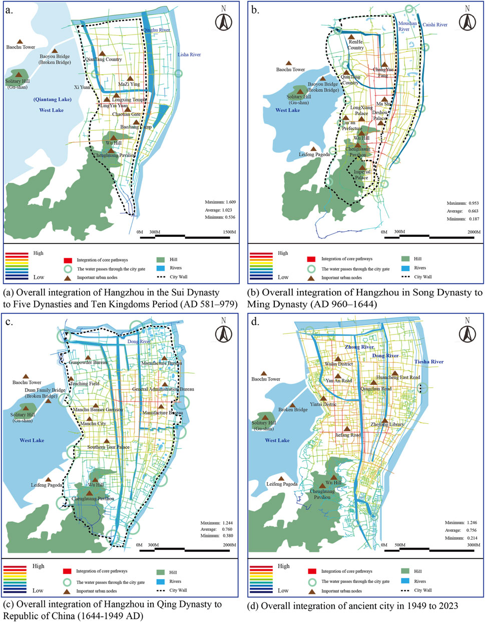
Figure 3. The overall integration of the ancient city of Hangzhou in four periods. (a) The overall integration of the Hangzhou in the Sui Dynasty to Five Dynasties and Ten Kingdoms Period (AD 581–979); (b) the overall integration of the Hangzhou in the Song Dynasty to Ming Dynasty (AD 960–1644); (c) the overall integration of the Hangzhou in the Qing Dynasty to the Republic of China (1644–1949 AD); (d) the overall integration of the Hangzhou from 1949 to present (Image source: drawn by the author).
The axes and integration development of the ancient city of Hangzhou present different changes, increases and integration relationships at different stages. It can be seen from Table 3 that the number of axes generally increases in the four different development stages. There are 982 axes from the Sui Dynasty to Five Dynasties and Ten Kingdoms Period (AD 581–979), which is the basic observation value; there are 1556 axes from the Song Dynasty to Ming Dynasty (AD 960–1644), with an increase of 158.45%; there are 6791 axes from the Qing Dynasty to the Republic of China (AD 1644–1949), with an increase of 436.44%; and there are 13,913 axes from 1949 to 2023, with an increase of 204.87%. It can be found that the period from the Qing Dynasty to the Republic of China (1644–1949) showed the fastest development. The average integration of the ancient city of Hangzhou showed an overall downward trend, and the integration in each period was significantly different (F = 12.34, p < 0.01). The average integration from the Sui Dynasty to Five Dynasties and Ten Kingdoms Period (581–979) was 1.023, ranking the highest, with better axis accessibility. The average integration from the Song Dynasty to Ming Dynasty (960–1644) was 0.663, ranking the lowest. The average integration from the Qing Dynasty to the Republic of China (1644–1949) and from 1949 to 2023 tended to be flat, and there was no significant change. From the standard deviation of the individual axis integration, it can be found that the individual integration differences of urban axes during the period from the Qing Dynasty to the Republic of China (1644–1949) were the most obvious, which may involve some issues such as large-scale location construction, changes in pattern deployment, and migration of social and political centers of gravity.
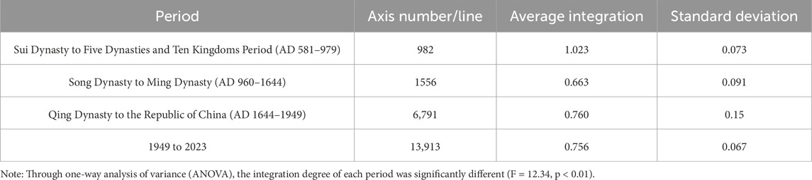
Table 3. Statistics of spatial integration in each period (global scale).
4.2.1 Sui dynasty to five dynasties and ten kingdoms period (AD 581–979): initial integration and local core
Following its development during the Southern and Northern Dynasties, Hangzhou transformed from a small mountainous county to the capital of a county. The Sui and Tang Dynasties centered the urban integration of Hangzhou on the main axis, with the combination of military garrisons and waterway systems supporting the initial development of the city’s spatial network. Although there were still local imbalances in network integration, the high integration of the core area laid the foundation for the subsequent expansion and functional evolution of Hangzhou City. As shown in Figure 3a, the spatial integration of Hangzhou’s urban form as a whole shows the characteristics of preliminary integration and a local core, and the spatial network gradually developed around the main axis in the middle of the city. Highly integrated paths were concentrated in the core area of the city, especially in the east of the inner city near the Shihe River, Yanqiao River, and Maoshan River (茆山河). The average integration was 1.023, the maximum was 1.609, and the minimum was 0.536, indicating that the connectivity of the urban network at that time was limited, but an integrated pattern with the core axis as the main body was initially formed.
The improvement in geographical conditions is an important basis for urban development. During the Sui and Tang Dynasties, as the sandbank swelled to the east and northeast of Hangzhou City, it provided flat geographical conditions for city construction. Simultaneously, the southern extension of Bei River’s South Canal traversed the city, leading directly to the Qiantang River, thereby transforming into a significant waterway that enhanced the spatial connectivity and optimized the resource flow efficiency.
The distribution of high-integration paths is closely aligned with military defense needs. Figure 3a illustrates the distribution of the six military camps from south to north along the eastern wall of the inner city, which relied on water systems such as the Shihe River and the Yanqiao River. These military camps were located in the middle of the sandbar in the city, especially in the flat area in the north of Luocheng, which not only enhanced the defense function of Hangzhou City but also coordinated with the natural terrain of the city, forming an area with high spatial integration. Furthermore, the military camps’ distribution aligned with the residential areas, reflecting the vibrant and prosperous urban life of that era.
Against this background, Buddhism and Taoism flourished in Hangzhou during the Sui and Tang dynasties, and temples and Taoist temples were distributed in core areas with a high degree of integration, further reflecting the correlation between the urban functional layout and residents’ spatial activities. The Wu Hill area of the inner city was home to numerous temples and Taoist temples, likely due to its mountainous terrain. Temples and Taoist temples in Luocheng (a second wall built around a city wall) outside the inner city were scattered, with the majority in Ciyun Hill and Baojia Mountain in the southwest of Luocheng. The area outside Luocheng was also an important distribution area for temples and Taoist temples. Nanping Mountain and Xizhao Mountain outside the west gate of Luocheng were densely distributed areas for temples and Taoist temples. Qiantang Lake (now West Lake) played a significant role in the urban landscape. Temples and Taoist temples were distributed across Wulin Mountain and Fenghuang Mountain in the west of Qiantang Lake, while Qiantang Lake and the surrounding mountains formed the entire landscape. This combination of religious space and urban settlements prompted the city’s spatial network to form functional connections and structural integration based on the core axis in the initial development stage.
4.2.2 Song dynasty to ming dynasty (960–1644): improved integration and spatial expansion
During the Song Dynasty to Ming Dynasty, especially in the Southern Song Dynasty, Hangzhou achieved strong development in terms of spatial integration and urban scale. The political core, the main axis of the Imperial Street and the water system, formed a highly integrated network pattern, which promoted the diversification of urban functions and the organic expansion of space and provided solid spatial support for Hangzhou’s prosperity as the capital of the Southern Song Dynasty. Figure 3b clearly demonstrates the significant improvement in the spatial integration of Hangzhou, the expansion and functional optimization of the overall network, and the maturation and complexity of the urban structure. Additionally, during this period, the average integration degree reached 0.663, with the highest value of 0.953, signifying a significant improvement in the connectivity and overall integration of the urban network compared to the Sui and Tang Dynasties, with high integration areas concentrated around core political and functional areas.
During the Southern Song Dynasty, the urban area of Hangzhou expanded to 1122 ha, and the imperial city area reached 50 ha. The urban spatial layout gradually expanded outward, with the political core serving as the center. The areas with high integration were mainly concentrated in administrative functional areas such as Deshou Palace, the Imperial Ancestral Temple, the Three Departments and Six Ministries, and five government offices. Also, they included essential facilities in the city, such as official kilns, pharmaceutical bureaus, and docks. These areas not only undertook the political and economic functions of the city but were also key nodes of high-integration paths in the urban network.
Imperial Street was the core land route of Hangzhou during the Southern Song Dynasty. It ran from the imperial city through the city center, extending to the post road along the Longshan River in the south and connecting to the post road along the Zitang River in the north, forming a north–south main axis with the highest degree of integration. This axis effectively connected the imperial city, commercial areas, and various important facilities, becoming the core framework of the urban spatial organization. In addition, most of the east–west roads in the city intersected with the north–south waterway system, connecting various city gates and functional nodes, further improving the overall connectivity of the city.
Water transportation played a key role in improving the integration of the Southern Song Dynasty. The artificial rivers, such as Maoshan River and Qinghu River, were about 94.35 km long and were an important part of the water system inside and outside the city. They connected with the Grand Canal and Zhejiang River system, especially in the north–south direction, forming a transportation system that interwove and complemented each other. This network of land and water not only met the needs of material transportation but also further improved the overall spatial integration of the city.
Therefore, the spatial network of Hangzhou during the Southern Song Dynasty displayed a multi-centered pattern, intertwining political, economic, and cultural functional areas. Areas with a high degree of integration served political and administrative activities, supported commercial trade, and supported the lives of residents. During the overall spatial expansion process, the waterway system combined with the north–south main axis and evenly distributed the east–west secondary axis to form an efficient and well-connected urban spatial network.
4.2.3 Qing dynasty to the republic of China (AD 1644–1949): network fragmentation and weakening integration
The spatial integration of Hangzhou from the Qing Dynasty to the Republic of China showed the characteristics of a high core area and a weak peripheral area. The existence and subsequent demolition of Manchu City and the formation and expansion of the city’s core axis (Qingchun Road and East Ring Road) reflected that the urban space underwent a process of fragmentation, reconstruction, and local optimization during this period. The network differentiation during this period provides a historical background and spatial framework for the urban reorganization of modern Hangzhou. As shown in Figure 3c, from the Qing Dynasty to the Republic of China, the urban spatial network of Hangzhou showed the characteristics of network differentiation and weakened integration. The average value of the overall integration was 0.760, the highest value reached 1.244, and the lowest value was 0.380, indicating that the core area of the city still maintained a high degree of integration, but the overall network connectivity was more differentiated than before, and the spatial integration of some areas was low.
In terms of the historical development of the ancient city, the construction of Manchu City was an important change in the urban form of the Qing Dynasty. Manchu City is located on the west side of the old city of Hangzhou and the shore of West Lake. Manchu City existed as a separate city within a larger city. The city of Hangzhou in the Qing Dynasty covered an area of more than 1,400 mu, and the urban area of Manchu City was 85 ha. There were six city gates and thousands of soldiers stationed inside. However, the existence of Manchu City caused a certain degree of separation in the spatial connectivity of the western area of Hangzhou, which reduced the integration of the area along the West Lake. The Republic of China’s government demolished Manchu City after the Qing Dynasty’s demise in 1913, retaining its street pattern, which influenced the overall layout of the subsequent urban space.
At the same time, the core paths of the urban network changed. Qingchun Road became the core integration path during this period, running east–west and connecting the urban center of Hangzhou. During the Ming and Qing Dynasties, Qingchun Road and its surrounding areas, including Yanqiao Street, Zhongqingli, and Caishiqiao Street, gradually formed a street system. These areas were further connected during the Republic of China period, creating an important urban axis. Built on the foundation of the East City Wall, the East Ring Road ran north–south, forming a highly integrated path that “crossed” with Qingchun Road. These two main roads supported the spatial connection of the core areas of the city and maintained a limited integration advantage.
Additionally, the Republic of China period saw the construction of Post Office Road along the railway in the eastern part of the city and the distribution of modern buildings such as Wanghai Tower, Renai Hospital, and commercial circles around it, creating new urban functional nodes and enhancing the integration of local areas. However, the overall spatial network of the city still exhibited distinct characteristics, and the integration of peripheral areas was relatively low, particularly in the southwest and north regions, where spatial connectivity was clearly inadequate.
4.2.4 From the founding of new China (1949) to the present: comprehensive integration and balanced optimization
In the modern era, Hangzhou’s urban spatial network has achieved comprehensive integration and balanced optimization. Hangzhou’s urban spatial network has expanded from a single axis to multiple network structures, significantly improving the transportation functions and spatial accessibility. The city’s primary and secondary roads are reasonably graded, and the spatial network is dense and balanced, supporting the efficient operation and functional linkage of urban space. As can be seen from Figure 3d, Hangzhou’s urban spatial network has achieved comprehensive integration and balanced optimization; the overall city’s integration has been significantly improved, and the spatial layout has become more balanced and orderly. The average urban integration in 2023 was 0.756, with the highest value reaching 1.246 and the lowest value being 0.214, reflecting that the urban network has gradually evolved from local concentration in the Ming and Qing Dynasties to a dense and balanced network structure.
From the perspective of the overall spatial pattern, the core paths are no longer limited to Qingchun Road and East Ring Road in the Ming and Qing Dynasties but gradually expanded westward to form several highly integrated paths such as Jiefang Road, Yan’an Road, Huansha Road, Qingchun Road, and Wenhui Road. These core paths are evenly distributed, connecting the main functional nodes of the city, such as Zhejiang Library, Wushan Square, Yintai Shopping Center, and other important urban spatial nodes, further improving the connectivity and accessibility of urban functional areas.
In addition, introducing modern transportation systems has played an important role in optimizing the urban spatial structure. With the urban road network improvement, the classification of main and secondary roads has become more apparent. The main roads have assumed higher traffic flow and spatial integration functions. In contrast, the secondary roads have strengthened the connectivity of local areas in the city, forming an efficient multi-level spatial network. In addition, the adjustment of the scale of modern urban streets and lanes has optimized the adaptability of the space, making the flow of resources and transportation functions more efficient and further promoting the overall integrated development of urban space. The high-value integration paths not only cover the core area of the old city but also extend to new functional areas such as Yan’an Road and Wenhui Road in the west and north, reflecting the balanced distribution of urban spatial functions and the optimization of network structure. Paths such as Huansha Road around the West Lake not only retain the continuity of the historical space but also combine this with modern functional needs, becoming a model of integrating historical protection and modern development.
4.3 Evolution of the ancient city from the perspective of choice
The changes in the average choice in the ancient city of Hangzhou from the Sui and Tang Dynasties to modern times are complex. Specifically, they showed an upward trend from the Sui and Tang Dynasties to the Five Dynasties (581–979) to the Song Dynasty to the Ming Dynasty (960–1644) and declined rapidly from the Qing Dynasty to the Republic of China (1644–1949), and in modern times (1949 to present), choice has returned to its previous level. This trend can be understood as problems with the city’s axis selectivity and connectivity from the Qing Dynasty to the Republic of China (1644–1949) (the maximum standard deviation reached 0.15). After the founding of New China, Hangzhou began to rapidly build urban infrastructure, which rapidly increased the choice mean of the city’s axis.
4.3.1 Sui dynasty to five dynasties and ten kingdoms period (AD 581–979): concentration and linearity of high-choice paths
During the Sui and Tang Dynasties, the spatial form of Hangzhou was mainly point-shaped, with choice concentrated on a few key paths, reflecting a high concentration and linear characteristics. From the spatial syntax analysis, we can see that the high-choice paths (now Wulin Road, Xinhua Road, Yan’an Road, and Jianguo Middle Road) mainly extended in the north–south direction, connecting the southern residential area with the northern market area and the east–west center of the city (now Qingchun Road, Xihu Avenue, Siyi Road, and Gaoyin Street in the north of Wu Hill), forming the core axis of resource flow and functional agglomeration. These paths were highly correlated with the core functional areas of the city, such as markets, administrative centers, and major transportation hubs, reflecting the concentration of resource and functional flows (Table 4).
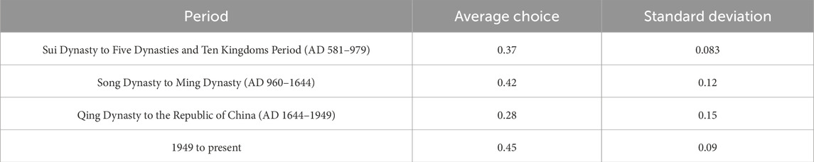
Table 4. Spatial choice statistics for each period (global scale).
Figure 4 reveals a concentrated choice, with a mean value of 0.37 and a standard deviation of 0.083, dominating the urban transportation network through a few high-value paths. The distribution of Choice R3, R7, and R11 shows that the high-value paths of choice covered the core area of the city and coordinated with the boundary streamlines formed by natural geographical elements (such as West Lake and Qiantang River). This compact network layout not only enhanced the functional connectivity of the core area but also improved the flow efficiency of urban resources.
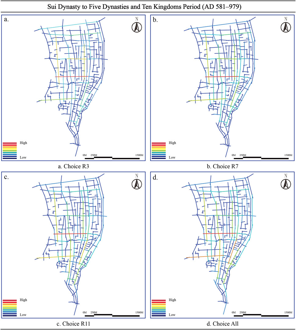
Figure 4. Choice analysis results during the Sui Dynasty to Five Dynasties and Ten Kingdoms Period (AD 581–979) (Image source: drawn by the author). (a) Choice R3. (b) Choice R7. (c) Choice R11. (d) Choice All.
The Sui and Tang dynasties’ high concentration of choice was closely associated with the city’s point structure, natural geographical advantages, and planning background. The cities in the Sui Dynasty were rearranged, focusing on the development of core areas, connecting residential areas, commercial areas, and administrative functional areas through a small number of high-choice paths, using natural barriers to form defense and functional zoning. Overall, the selectivity characteristics of this period reflect the compactness and functional optimization of the urban spatial form, laying the foundation for subsequent urban expansion.
4.3.2 Song dynasty to ming dynasty (AD 960–1644): Network expansion and decentralization features
During the Southern Song Dynasty, Hangzhou’s urban spatial network showed significant expansion and polycentricity. Overall, the urban network of Hangzhou during the Southern Song Dynasty underwent a transformation from a single center to multiple centers in its spatial layout. The expansion and distribution of high-choice paths reflected the complexity of urban functional areas and the optimization of network organization, making it a national network. The prosperity of the Sex Central City laid a solid foundation. From the analysis results of Choice R3, R7, R11, and Choice All in Figure 5, it can be seen that the range of high-choice paths significantly expanded compared with the Sui and Tang Dynasties; the path distribution was more even, and the high values were concentrated in the administrative center, commercial area, and water transportation arteries of the city, reflecting the spatial characteristics of a multi-center network.
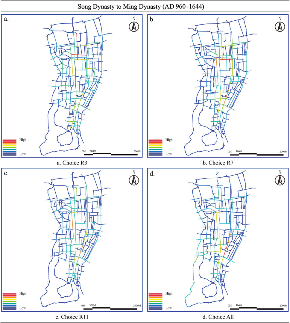
Figure 5. Choice analysis results during the Song Dynasty to Ming Dynasty (AD 960–1644) (Image source: drawn by the author). (a) Choice R3. (b) Choice R7. (c) Choice R11. (d) Choice All.
The diversification of urban functional needs closely correlated with the significant expansion of high-choice paths during the Southern Song Dynasty. Lin’an, the political and economic center of the country, distributed its core routes along the Maoshan River, the Qinghu River, and other water systems, thereby strengthening the transportation connections both within and outside the city. The results of choice clearly show the intersection of the north–south main axis Imperial Street (now Yan’an Road and Zhongshan Middle Road), and the east–west secondary axis (now Tianjin Road) became a concentrated area with high selectivity, particularly close to the commercial center area; its path selectivity performed outstandingly in both the R7 and R11 analyses. The formation of this multi-directional high-value path reflects the efficient connection between the functional areas within the city and the external water transport network. Data analysis further revealed the characteristics of choice during the Southern Song Dynasty. The mean choice value was 0.42, and the standard deviation was 0.12, indicating that the connectivity and complexity of the urban network significantly improved, and the overall path distribution uniformity was enhanced, but the selection advantage of the core path was still outstanding. This balanced and polycentric network structure not only supported the efficient flow of functions within the city but also strengthened the regional economic radiation capability through path expansion.
4.3.3 Qing dynasty to the republic of China (AD 1644–1949): network fragmentation and weakening of choice
From the Qing Dynasty to the Republic of China, Hangzhou’s choice of urban spatial network displayed significant differentiation and weakening characteristics. In general, Hangzhou’s urban network weakened during the transition from the 1644 to the 1949. The socio-political background and the fragmentation of the urban form largely restricted choice. Although a few high-choice pathways maintained functional connections in the core region, the connectivity and functionality of the overall network significantly declined. The choice characteristics of this period posed important challenges for the connectivity restoration and functional optimization of subsequent modern urban planning.
The city’s core areas and a few key transportation axes, such as Qingchun Road, Jianguo Middle Road, and Zhongshan Middle Road, were primarily home to high-choice paths, while the selectivity in peripheral areas significantly decreased, weakening the overall connectivity and balance of the network (Figure 6). The distribution of choice during this period reflected the establishment of Manchu City in the Qing Dynasty and the impact of subsequent urban fragmentation on the spatial network. The intersection of the north–south main axis and the east–west secondary axis concentrated high-choice paths, particularly in the core areas near the business and administrative districts. The Choice R7 and Choice R11 results reveal that the presence of a military garrison in the northern area of the city reduced the number of high-choice paths, leading to a decrease in the network connectivity in the north–south direction. On the other hand, the east–west path experienced a slight enhancement in selectivity, albeit with a limited overall effect. Data analysis shows that the mean value of choice during this period dropped to 0.28, and the standard deviation increased to 0.15, indicating that the distribution of choice values was more uneven. The reduction in high-choice-value paths and the increase in low-choice-value paths led to a decrease in the efficiency of the transportation network, especially in terms of north–south connections. The results of Choice All further reveal that network fragmentation greatly reduced the importance of paths in peripheral areas, and the connections between urban functional areas mainly relied on a few high-choice paths.
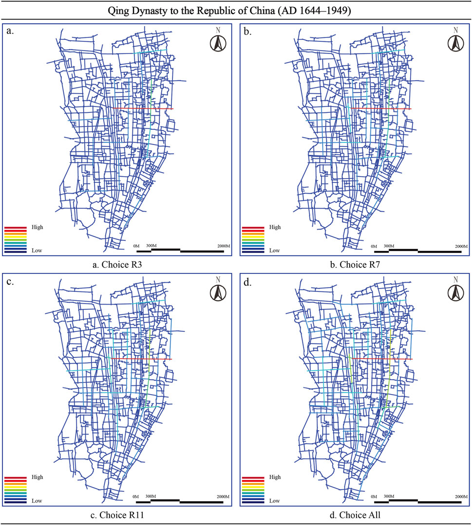
Figure 6. Choice analysis results from the Qing Dynasty to the Republic of China (AD 1644–1949) (Image source: drawn by the author). (a) Choice R3. (b) Choice R7. (c) Choice R11. (d) Choice All.
4.3.4 From the founding of new China (1949) to the present: network optimization and connectivity reconstruction
After the founding of New China, Hangzhou’s urban spatial network exhibited notable optimization and connectivity reconstruction features. Overall, modern Hangzhou’s transportation network transformed from a single-centered or fragmented state in historical periods to a modern network structure with multiple functions and strong connectivity. This optimization and reconstruction of choice not only met the needs of rapid urban development but also strengthened the balance between cultural heritage protection and modern functional expansion through comprehensive planning, providing strong support for Hangzhou as a global city.
From the analysis results in Figure 7, we can see that the choice of high-value paths not only covers the core functional areas but also extends to the peripheral areas of the city, forming a balanced and multi-centered network structure. This network optimization feature fully reflects the efforts of modern urban planning in improving connectivity and functional coordination. The city’s main axis and the connection points between old and new urban areas concentrate on high-choice paths. The Choice All map shows that high-choice-value paths, Yan’an Road, Qingchun Road, Fengqi Road, and Jiefang Road, run through the main north–south axis and the east–west secondary axis, connecting traditional historical urban areas and modern functional new areas. The optimization of these paths has significantly enhanced the connections between different functional areas, especially the traffic efficiency between the old city and new development areas (such as Qiantang New District and Yuhang District). From the distribution of Choice R7 and Choice R11, it can be seen that the path choice in the peripheral area has improved significantly compared with the historical period, indicating that the balance and overall connectivity of the network have been enhanced. Data analysis further supports this conclusion. The average choice value during this period increased to 0.45, and the standard deviation decreased to 0.09, indicating that the network choice distribution was more even, and the gap between the core secondary paths narrowed. This balanced distribution reflects the “people-oriented” design concept in modern urban planning, which reduces uneven resource distribution and traffic flow by optimizing traffic and functional layout.
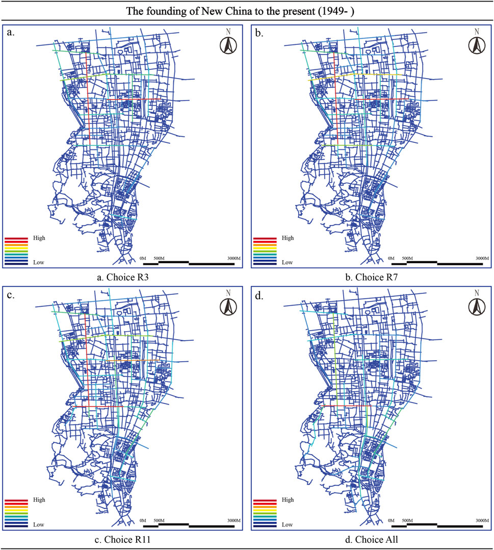
Figure 7. Choice analysis results from the founding of New China to the present (1949-) (Image source: drawn by the author). (a) Choice R3. (b) Choice R7. (c) Choice R11. (d) Choice All.
4.4 Evolution of ancient city’s from the perspective of intelligibility
This study quantified the intelligence of axes in different historical periods through space syntax analysis, revealing the evolutionary laws and logic of urban morphology. In general, the evolution of the intelligence of the ancient city of Hangzhou reflects the adaptive adjustment of the city to social needs, natural conditions, and functional optimization in different historical periods. From the compact concentration in the Sui and Tang dynasties to the diversified integration in the Southern Song Dynasty and to the spatial fragmentation and optimization reconstruction in modern times, the evolution of spatial morphology in different periods reflects the interaction between historical process and planning wisdom (Figure 8).
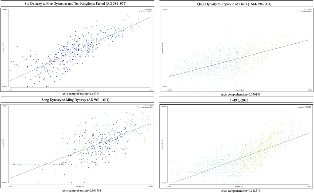
Figure 8. Results of the intelligibility analysis of the four periods of the ancient city of Hangzhou (Image source: drawn by the author).
The Sui and Tang dynasties were the foundation stage of Hangzhou’s urban form. The intelligibility of the axis reached 0.65774, indicating that the city already had high spatial accessibility in its initial development. Phoenix Mountain and its surrounding areas centered the city’s core axis, organically connecting residential areas, commercial areas, and natural geographical elements (such as West Lake and Qiantang River). During this period, the axis distribution was relatively compact, mainly serving small-scale residential and commercial activities while using natural barriers to strengthen defense functions. According to the data distribution, the main axis of the city presented a radial structure centered on the core point. The centralization of early urban planning is indicated by the high mean and small dispersion of the axis comprehensive value (standard deviation of 0.073).
During the Southern Song Dynasty, Hangzhou was the political, economic, and cultural center of the country, and its urban space expanded significantly. The intelligibility value of the axis was 0.501788, which was slightly lower than that of the Sui and Tang Dynasties but more balanced. As cities expand in size, the complexity of spatial networks fragments cognitive accessibility, leading to this change. However, looking at the overall distribution, the city’s axis uniformity significantly improved, the network density increased, and the functional zoning became clearer. The linear expansion, formed along water systems such as the Maoshan River and Qinghu River, strengthened the city’s spatial integration capabilities. The high value of local axes (such as the axis running through the commercial core area and administrative center) illustrates the optimized design of traffic flow lines and functional nodes. Data analysis shows that the comprehensive value distribution of the city’s main axes during the Southern Song Dynasty was more dispersed, with the standard deviation increasing to 0.091, reflecting the need for diversified functions after the expansion of the city’s scale.
Social transformation and political changes (characteristics of fragmentation and transformation) affected the urban form from the Qing Dynasty to the Republic of China. The intelligibility of the axis dropped to 0.379183, the lowest value in each period. This change suggests a degree of fragmentation in the urban spatial network, particularly due to the establishment of Manchu City and the partial demolition of city walls, which negatively impacted the overall spatial connectivity. The skewed distribution of the axis comprehensive value, which was mostly left-skewed, shows how the functional core area was gradually shrinking and how space resources were being spread out unevenly. The locality of the axis distribution was enhanced, and some axes (such as those leading to newly established military stations and traffic arteries) showed high values, but the overall network density decreased. The significant gap (about 0.12) between the mean and the median illustrates the fragmented character of urban planning.
Modern Hangzhou has achieved restorative growth in the intelligibility of its axes through a series of modern planning and regional integration, reaching 0.512515. The urban spatial form integrates traditional historical elements, such as the West Lake cultural landscape, with modern functional zoning and a comprehensive transportation network, thereby enhancing the accessibility and integrity of the spatial network. According to the data analysis, the comprehensive value of the modern urban axis presents a normal distribution, and the standard deviation dropped to 0.067, indicating that the city’s spatial network is more uniform, and the connection between the core area and the peripheral area is closer. The high-value axes around the new urban areas (such as Qiantang District and Yuhang District) and the core areas further increase the overall intelligibility and achieve a balance between historical and cultural protection and modern development by optimizing greenways and transportation systems.
5 Discussion
5.1 Changes in and causes of the architectural functional attributes
The functional attributes of buildings in the ancient city of Hangzhou have experienced significant changes in different periods. This phenomenon is the result of a variety of social, economic, and political factors. In the development of cities, political and economic factors play a crucial role in the urbanization process. Political decisions determine the administrative status, resource allocation, and social stability of cities. A developed city tends to obtain more infrastructure investment and development opportunities, attracting a large influx of population and capital. Economic development is the main driving force behind the urbanization process (Liu et al., 2010). Trading ports (such as Singapore), the birthplace of the Industrial Revolution (such as Manchester), and modern technology centers (such as Silicon Valley) have all grown rapidly due to the prosperity of specific economic activities. Economic success not only changes the physical appearance of a city but also shapes its social structure and cultural characteristics. Politics and economics interact with each other to jointly shape the unique development patterns of different cities. Successful urban planning should consider both factors to achieve sustainable development and maximize social wellbeing.
In Figure 9, we can clearly see that the architectural functional divisions of the ancient city of Hangzhou continued to evolve over time, showing a trend from simple to complex and from single-to multi-functional areas. Analyzing the changes in building functions in various periods, we can reflect on the city’s different development needs and trends in defense, administration, residence, and commerce. This helps to understand the urban form, functional layout, and the development logic behind it.
(1) Southern Song Dynasty: The functional layout was dominated by the military, supported by a water network, and prioritized defense. During this period, Lin’an City’s (now Hangzhou) topography and natural conditions influenced its spatial layout, leading to adopting a tailored planning method. This planning fully utilized the topography’s advantages, concentrated power and defense functions in the core area, and created an urban space relatively isolated from both the inside and outside (Cao et al., 2023). The city was centered on the imperial city, which was built on the mountain. The imperial city distributed military facilities, including civil and military offices and barracks, around it. The city walls surrounded the entire city, forming a strict defense system. As the capital, the urban architecture of Lin’an Prefecture (now Hangzhou) included not only the imperial city but also royal buildings, provincial offices at all levels of the central government, and residences of emperors and generals distributed inside and outside the capital (Fu et al., 2019b; Lam, 2017). The evenly distributed gates on the city wall served as the city’s entrances and exits, facilitating easy control over the connection between the inside and outside of the city. Military facilities were close to the imperial city and the core of power, which showed that the Southern Song Dynasty Lin’an City attached great importance to security and also made dispatch more efficient. The moat further strengthened the defense function. The combination of military areas and administrative areas reflected the urban planning concept of Lin’an City, which was mainly based on governance and defense, but it also greatly restricted the development and expansion of land.
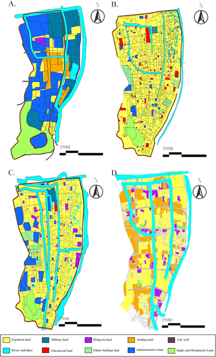
Figure 9. Changes in the functional attributes of land use in the ancient city of Hangzhou. (A) The land function changes in the ancient city in the Southern Song Dynasty; (B) the land function changes in the ancient city in the Ming and Qing Dynasties; (C) the land function changes in the ancient city in the Republic of China (AD 1644–1949); (D) the land function changes in the ancient city 1949 to 2023 (Image source: the author drew this based on the Illustrated History of Hangzhou City and West Lake).
The layout of other functional areas in the city was compact and orderly, forming a coordinated spatial structure with the imperial city and military areas. Lin’an City primarily concentrated its commercial land along the main roads and near the water network. The intersection of the east–west and north–south main roads was the core node of commercial activities. The water network was densely distributed inside the city, providing domestic water and drainage functions for residents and dividing various functional areas, playing a dual role of connection and separation. The scale of the commercial area was relatively limited, mainly to meet the living needs of residents in the city, and it did not highlight strong outward-oriented economic characteristics. Overall, Lin’an City was a capital of the Southern Song Dynasty, with politics and military as the core, supplemented by residential and commercial functions, with a rigorous layout and complete structure.
(2) Ming and Qing Dynasties: Residential functions expanded and gradually differentiated urban functions. During the Ming and Qing Dynasties, the land use of Lin’an City gradually changed from a traditional closed pattern to an open modern city. Defensive facilities such as city walls and moats still occupied an important position in the city in the Ming Dynasty, but with the rise of the economy and foreign trade in the late Qing Dynasty, their functions gradually weakened, and the area of military land also gradually shrank. Especially in the late Qing Dynasty, with the increase in population, the peripheral land was more developed into residential areas. The core functions of the city were more concentrated on administrative and residential functions. The residential areas were close to the core areas, and the functions were closely connected.
(3) Republic of China (1912–1949): Here, there was functional diversification and extension of the urban form. The most significant change in Lin’an City during the Republic of China (1912–1949) was the gradual demolition of the city walls, marking the city’s transformation from a closed defensive type to an open functional development. Simultaneously, the city’s spatial layout shifted from defense to economic, transportation, and functional needs. The improvement in transportation convenience made the spatial layout of urban areas pay more attention to the connection between main roads and peripheral areas, promoting the development of land use in an open and multi-center direction.
The yellow area occupies most of the city and represents the expansion of residential areas. This shows that the main function of Lin’an City during the Republic of China (1912–1949) changed from defense and administration to focusing on residence and daily life. At the same time, the defensive functions of the city walls and moats gradually weakened, and the urban space gradually extended outside the city, forming a more open urban pattern along the main transportation axes (east–west and north–south). In addition, the importance of commercial functions in the city increased significantly. The water network was still an important part of the city, but it served more commercial and transportation functions than pure defense or drainage. Urban planning during the Republic of China (1912–1949) focused more on transportation-oriented development. The combination of water and land transportation became the key basis for urban functional zoning, which strengthened economic connections inside and outside the city. These changes demonstrate the modernization process of Lin’an City’s economy, transportation, and spatial organization during the Republic of China (1912–1949).
(4) Since the founding of the People’s Republic of China (1949 to present), commercial and residential areas have been integrated with modern development. The modern urban pattern has undergone significant changes compared with the historical period, reflecting the complexity of functional divisions and the diversification of space utilization in the city during the modern development process. The yellow area still occupies the main space in the city, indicating the core position of residential land in urban functions. The layout is more uniform and covers a wider range, adapting to the densely populated residential needs of modern cities. Simultaneously, orange areas cluster around residential areas and traffic arteries, symbolizing the significance and activity of commercial land. Many areas of the city have seen the penetration of commercial activities, which maintain close connections with residential areas. Urban planning enhances the importance of cultural, religious, and public service functions. Urban core areas and node locations primarily distribute these functional lands, providing convenient transportation for residents. The road network has been further developed; the main roads and branch roads running through the city are closely connected, and the accessibility of urban space has been greatly improved.
Furthermore, through GIS-supervised classification and old map digitization, this study quantified the zoning characteristics of land use functions in different periods of the ancient city of Hangzhou (Table 5). Quantitative analysis shows that the functional zoning of the ancient city of Hangzhou presents significant temporal and spatial heterogeneity. Specifically, first, military land dropped sharply, from 42.3% in the Southern Song Dynasty to 0.8% in modern times (annual average reduction rate of 1.2%, R2 = 0.94). Second, residential land increased first and then stabilized; it reached a peak of 53.6% in the Ming and Qing Dynasties and fell back to 48.4% in modern times due to green space planning. Third, green space has systematically recovered; satellite images from 1971 to 2024 show that the area of farmland around West Lake converted into green space reached 63.5% (p < 0.01). The above changes confirm the transformation of the city from “defense priority” to “human settlement–ecological synergy.”
Table 5. Proportion of functional land area in Hangzhou ancient city in different periods (unit: %).
The land use function changes in the ancient city of Hangzhou underwent significant changes, from low mixing to medium mixing and finally to high mixing. From the results in Table 6, one can see that the degree of mixing developed in different periods generally shows an upward trend. The Shannon H′ increased most significantly during the Song Dynasty to Ming Dynasty (AD 960–1644), reaching a value of 1.58, an increase of 141.07% compared to the previous period. Therefore, regarding the degree of mixture and urban functional pattern, the city underwent a transformation through the four core functions of “military function dominance—residential function expansion—commercial and residential integration—commercial, residential, and green space balance.”
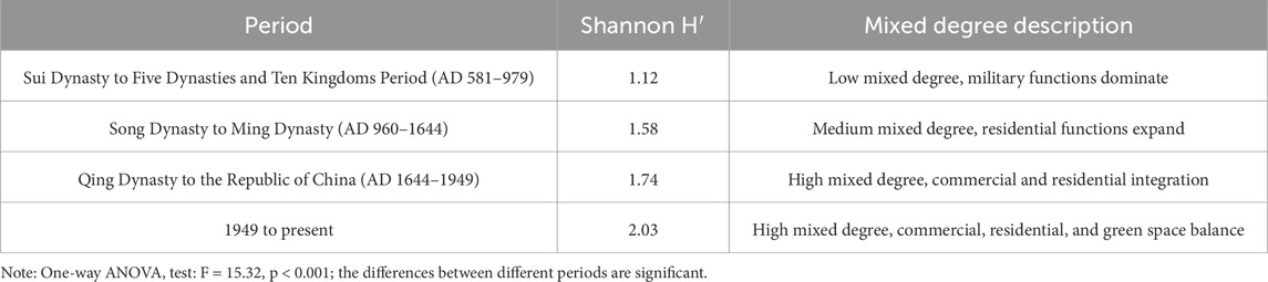
Table 6. Analysis of functional mixing degree.
In general, the evolution of the spatial form of the ancient city of Hangzhou has been greatly influenced by social, economic and cultural factors. First, the social factors of the evolution of the ancient city of Hangzhou have penetrated. The Xiangfang system of the Southern Song Dynasty (1129) opened Lifang and gave birth to the mixed commercial and residential model along the street of Qinghefang. The construction of “complex future communities” in the 21st century (such as Yangliu County Community) reconstructed neighborhood units through resident participatory planning, social organizations promoted the organic renewal of the Mantoushan shantytown, and grassroots forces continued to correct the micro-texture of the city. Secondly, the economy drove the evolution of the ancient city of Hangzhou. After the Grand Canal of the Sui and Tang Dynasties was connected, the Yanqiao River in the city formed a dock–warehouse–market complex, laying the foundation for the commercial city gene; the rise of Alibaba in the 21st century (1999) promoted the spread of the future science and technology city to the west, and the live broadcast economy reshaped the spatial structure of the Jiubao clothing market, showing the traction of industrial iteration on urban expansion. Finally, culture shaped the evolution of the ancient city of Hangzhou. The aesthetics of the West Lake landscape have been sublimated from the poems of Tang and Song Dynasty literati to the construction paradigm of “city and lake integration.” Leifeng Pagoda (975) and Baochu Pagoda (968) constructed the visual axis to guide the expansion of settlements. The “West Lake Expo” during the Republic of China promoted the transformation of the traditional landscape city concept to modern cultural tourism functions, and cultural heritage has continued to guide the reconstruction of spatial value. From the overall layout, multi-dimensional interaction has reshaped the urban structure of Hangzhou, and the modern main urban area of Hangzhou has formed an urban form with mixed functions and multi-center development. The spatial layout is more open and orderly, reflecting the development characteristics of modern urban transportation-oriented and functional complexes.
5.2 Changes in satellite images
The researchers discovered some changes in land types and urban details by comparing the US Keyhole satellite historical images of Hangzhou from 1971, 1979, and 2024. With the continuous advancement in urbanization, the land use pattern has undergone major changes. The “Integration of the South Line of West Lake Scenic Area, Returning the Lake to the People” campaign launched the reconstruction of the urban ecosystem and called for the construction of green space around the lake. The farmland originally located by the West Lake has gradually turned into green space. The farmland near Lei Hill (雷峰) and Wu Hill (吳山) has shown a clear trend of change. Urbanization has led to the establishment of communities in various regions around West Lake. The abandoned green space in the back garden of the former imperial city in the south of Wu Hill is now Nanxing Street. Due to its beautiful environment, it has become one of the core residential areas for residents of the ruins of the Southern Song Dynasty Imperial City (Figure 10). Residential areas have gradually replaced the lands originally used for agricultural production as the population grows, and urban expansion demands it. Modern buildings replaced traditional agricultural landscapes in this process, forming emerging residential areas.
Figure 10. Comparison of the farmland between mountains from satellite images from 1971, 1979, and 2024. The direction in the satellite image is due north (Image source: the author annotated based on satellite images).
At the same time, green land gradually replaced the residential areas near West Lake (Figure 11). In this process, developers demolished the original houses and turned large areas of land into parks. In order to meet the leisure needs of urban residents, developers also dug a small pier by the lake, which is now the Dahua Hotel Pier. Simultaneously, the bungalows that were originally situated by the lake have also experienced significant transformations. Along the lake, a new West Lake Tiandi Tourism and Leisure Landscape has emerged. It is located at the Yongjin Pond on the south bank of West Lake. While retaining some of the characteristic old buildings within the scope, it draws inspiration from Hangzhou’s unique gardens and historical buildings. Modern block forms, such as natural fashion, are integrated with these elements to create a comprehensive and fashionable integrated block that integrates catering, retail, culture, and entertainment. As urbanization accelerates, Jiangjun Road and Kaiyuan Road boast superior geographical locations and excellent views of West Lake, leading to the gradual replacement of the original low-rise bungalows with high-rise structures.
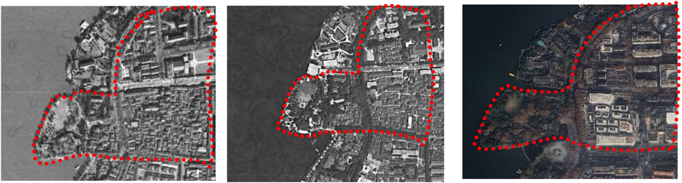
Figure 11. Comparison of the transformation of the Lake Shore Residential Area from satellite images from 1971, 1979, and 2024. The direction in the satellite image is due north (Image source: the author annotated based on satellite images).
On the other hand, the contours of Wu Hill have also changed. Large-scale excavating of the mountain has gradually flattened the original natural mountain landscape into land suitable for construction (Figure 12). The government transformed and divided the original hillside area near the ancient tree park into plots of varying sizes. The government planned it as a modern residential area, providing sufficient living space for the growing urban population (Figure 13).
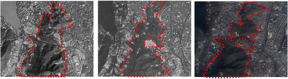
Figure 12. Comparison of the Wu Hill surrounding area from satellite images from 1971, 1979, and 2024. The direction in the satellite image is due north (Image source: the author annotated based on satellite images).
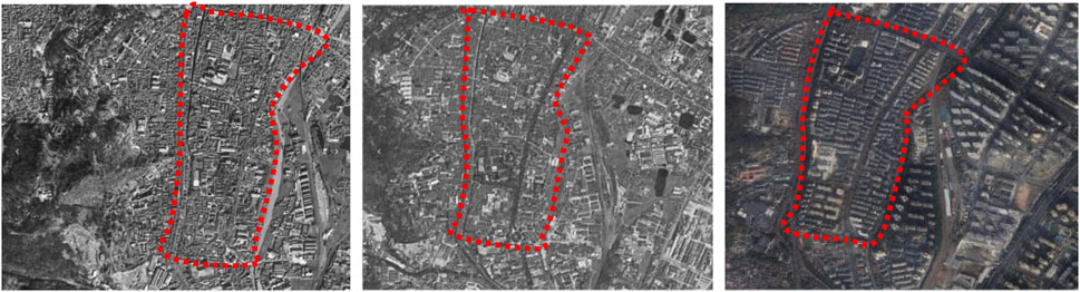
Figure 13. Comparison of the Wu Hill surrounding residential area from satellite images from 1971, 1979, and 2024. The direction in the satellite image is due north (Image source: the author annotated based on satellite images).
5.3 Limitations
Although this study explored the historical evolution of the ancient city of Hangzhou in detail through space syntax, old map translation analysis, and US Keyhole satellite historical image change analysis, there are still some limitations. First, acquiring research data relies on old maps, local chronicles, and historical satellite images. Time and space factors may affect the accuracy and completeness of these data, leading to data bias. For instance, this study discovered a scarcity of map data from the Tang Dynasty, the Five Dynasties and Ten Kingdoms, and the Yuan Dynasty, potentially leading to certain discrepancies in our comprehension of continuity. The reality is that the current ancient city of Hangzhou no longer exists. After demolishing the city wall, verifying and investigating the ancient city’s past became challenging, potentially leading to deviations. In addition, the study mainly focused on the evolution of the material spatial form, while the analysis of social, economic, cultural, policy, administrative, and other factors at that time was relatively limited. Future research can combine more interdisciplinary methods to solve this problem, such as using social network analysis and other methods to create multidimensional analysis frameworks such as “society–economy–culture–policy,” focusing on capturing the transformation of urban development paradigms under the interweaving of traditional and emerging digital forces and further exploring the various driving factors behind changes in urban form.
6 Conclusion
As a typical mountain and water city, the evolution of Hangzhou’s historical morphology reflects the development process of traditional Chinese cities and reveals the unique spatial structure, social and economic functions, and the profound connection between the natural environment and the mountain and water city. This study took the ancient city of Hangzhou as a case study and discussed the evolution of the urban morphology of the ancient city of Hangzhou in four periods: the Sui Dynasty to Five Dynasties and Ten Kingdoms Period (581–979), the Song Dynasty to Ming Dynasty (960–1644), the Qing Dynasty to the Republic of China (1644–1949), and since the founding of the People’s Republic of China (1949 to present). The main conclusions are as follows: 1) The integration of the ancient city of Hangzhou evolved from local centralization in the Sui and Tang Dynasties to spatial expansion and improvement in the Southern Song Dynasty, followed by differentiation and weakening from the Qing Dynasty to the Republic of China and, finally, to comprehensive optimization and balance in the modern period. 2) The evolution of the morphological understanding of the ancient city of Hangzhou reflects the city’s adaptive adjustment to the social needs, natural conditions, and functional optimization in different historical periods. From the compact concentration in the Sui and Tang Dynasties to the diversified integration in the Southern Song Dynasty and then to the spatial fragmentation and optimization reconstruction in modern times, the evolution of spatial forms in different periods reflects the interaction between historical processes and planning wisdom. 3) From the perspective of historical land function changes, the architectural functional zoning of the ancient city of Hangzhou has evolved over time, demonstrating a trend from simple to complex and from single-to multi-function areas. This evolution reflects the different development needs and trends of the city in terms of defense, administration, residence, commerce, and so on. 4) Overall, the ancient city of Hangzhou has experienced a dynamic process of building city walls, demolishing city walls, and integrating the city into the landscape, fully demonstrating the concept of building a city with mountains and rivers.
This study’s in-depth discussion of the evolution of the ancient city of Hangzhou provides important inspiration and reference for modern urban planning and the protection of historic cities. First, the spatial integration and functional optimization process of the ancient city of Hangzhou in history reveals that urban development should focus on coordinated coexistence with the natural environment. Modern urban planning should learn from this concept, strengthen the protection and utilization of mountain and water resources, promote the organic integration of cities and nature, and avoid the ecological damage caused by overdevelopment. Second, the adaptive adjustment of the ancient city of Hangzhou to social needs in different historical periods shows that the evolution of the urban form should be flexible and inclusive. Modern urban planning needs to respect the historical context and regional characteristics, while meeting functional needs and avoiding the phenomenon of homogenization of thousands of cities. Especially in the protection of historic cities, attention should be paid to the protection of traditional spatial patterns and architectural styles, while exploring the compatibility of traditional and modern functions, such that historical and cultural heritage can be revitalized in modern cities. In addition, the evolution of the ancient city of Hangzhou from building city walls to integrating the city into the landscape embodies an open and inclusive urban development concept. Modern urban planning should break the closed spatial model, promote the interaction between cities and nature, and create a livable, resilient, and sustainable urban environment. Hangzhou’s evolution offers a valuable lesson for modern urban planning, highlighting the need to balance historical heritage and innovation for harmonious coexistence with nature.
Data availability statement
The raw data supporting the conclusions of this article will be made available by the authors, without undue reservation.
Author contributions
YeH: Conceptualization, Formal Analysis, Funding acquisition, Investigation, Methodology, Resources, Writing – original draft, Writing – review and editing. YhH: Formal Analysis, Software, Writing – original draft. YC: Conceptualization, Data curation, Formal Analysis, Methodology, Supervision, Validation, Visualization, Writing – original draft, Writing – review and editing. JS: Formal Analysis, Methodology, Software, Writing – original draft, Writing – review and editing. SY: Data curation, Funding acquisition, Investigation, Project administration, Visualization, Writing – original draft, Writing – review and editing. LH: Funding acquisition, Project administration, Resources, Supervision, Writing – review and editing. LZ: Conceptualization, Writing – review and editing. YG: Supervision, Writing – review and editing.
Funding
The author(s) declare that financial support was received for the research and/or publication of this article. This article was supported by the high-level talent research start-up project of Hangzhou Vocational and Technical College (grant number: RCXY202431) and is the research result of Hangzhou Philosophy and Social Science Research Base “Excellent traditional culture inheritance, transformation and Development Research Center.” This study is also a phased result of the first batch of teaching reform projects of Zhejiang Province’s higher vocational education in the “14th Five-Year Plan” “Study on Digital Transformation Countermeasures for Higher Vocational Art Design Majors under the Background of AIGC” (Grant Number: jg20230089). The project was supported by the Zhejiang Provincial Humanities and Social Sciences Foundation of China (Grant No. 25NDJC159YB), (Grant No. 24NDQN150YBM).
Acknowledgments
We would like to thank the staff who assisted in locating documents and old maps and conducting field research.
Conflict of interest
The authors declare that the research was conducted in the absence of any commercial or financial relationships that could be construed as a potential conflict of interest.
Generative AI statement
The author(s) declare that no Gen AI was used in the creation of this manuscript.
Publisher’s note
All claims expressed in this article are solely those of the authors and do not necessarily represent those of their affiliated organizations, or those of the publisher, the editors and the reviewers. Any product that may be evaluated in this article, or claim that may be made by its manufacturer, is not guaranteed or endorsed by the publisher.
References
Adams, D., and Tiesdell, S. (2012). Shaping places: urban planning, design and development. London, UK: Routledge.
Albrechts, L. (2004). Strategic (spatial) planning Reexamined. Environ. Plan. B Plan. Des. 31 (5), 743–758. doi:10.1068/b3065
Baihao, L., and Sha, W. (2016). The transformation and influence of overseas commerce of Mingzhou port-city in Tang and Song Dynasties (821-1279)——concentrated on the historical relics. Int. Plan. Hist. Soc. Proc. 17 (3), 75–90. doi:10.7480/iphs.2016.3.1254
Bao, S. (2005). Shanshui city: China’s human settlement environment in the 21st century. Urban Hous. 12, 114–117. Available online at: https://chn.oversea.cnki.net/KCMS/detail/detail.aspx?dbcode=CJFD&dbname=CJFD2005&filename=CSZZ200512022&uniplatform=OVERSEA&v=suhUDm7dV_GIImFWovUKZ7pKte7tmdh2qAKZ8fO8qoQJ1088ag4Un4JitmlkzhQF.
Burghardt, K., Uhl, J. H., Lerman, K., and Leyk, S. (2024). Universal patterns in the long-term growth of urban infrastructure in US cities from 1900 to 2015. arXiv preprint arXiv:2412.13181. doi:10.48550/arXiv.2412.13181
Caiyun, C. (2023). From national capital to provincial capital: transformation of Hangzhou’s political spaces in the Early Yuan Dynasty. Chin. Stud. Hist. 56 (4), 333–361. doi:10.1080/00094633.2024.2320058
Cao, K., Xie, W., Zhu, J., and Wei, F. (2023). Commercial culture as a key impetus in shaping and transforming urban structure: case study of Hangzhou, China. Sustainability 15 (13), 10620. doi:10.3390/su151310620
Capello, R., and Camagni, R. (2000). Beyond optimal city size: an evaluation of Alternative urban growth patterns. Urban Stud. 37 (9), 1479–1496. doi:10.1080/00420980020080221
Case, D. O. (1991). The collection and use of information by some American historians: a study of motives and methods. Libr. Q. 61 (1), 61–82. doi:10.1086/602298
Du, P., and Koenig, A. (2012). “History of water supply in pre-modern China,” in Evolution of water supply through the millennia, 169–222.
Duan, X. (2020). The rise of West Lake: a cultural landmark in the Song dynasty. Seattle, Washington, United States: University of Washington Press.
Fang, M. (2009). Exploration and reflection on the concept of “mountain and water city” in urban planning and design: Taking the urban design of Xixin District in Yongkang City as an example. Decoration, 137–138. Available online at: >https://chn.oversea.cnki.net/KCMS/detail/detail.aspx?dbcode=CJFD&dbname=CJFD2009&filename=ZSHI200905053&uniplatform=OVERSEA&v=upa3nTMloHg0yfQXv554BQdKVuuWmxUhp2xZEDiC0YW0U6qdQ1lB_KrUGTEmxX3v.
Feng, J., and Zhou, Y. (2005). Suburbanization and the changes of urban internal spatial structure in Hangzhou, China. Urban Geogr. 26 (2), 107–136. doi:10.2747/0272-3638.26.2.107
Fu, C., Cao, W., Fu, C., and Cao, W. (2019a). “Cities during the five dynasties and the ten Kingdoms Period, and the turning point of Chinese urban history,” in Introduction to the urban history of China. China connections (Singapore: Palgrave Macmillan). doi:10.1007/978-981-13-8207-9_16
Fu, C., Cao, W., Fu, C., and Cao, W. (2019b). Lin’an in southern Song—a great Convergence of southern and northern cultures. Introduction to the Urban History of China, 213–230. doi:10.1007/978-981-13-8207-9_18
Fu, L. (2005). Qian Xuesen’s thoughts on landscape cities and their research. J. Xi’an Jiaot. Univ., 65–75. Available online at: https://chn.oversea.cnki.net/KCMS/detail/detail.aspx?dbcode=CJFD&dbname=CJFD2005&filename=XAJD200503013&uniplatform=OVERSEA&v=Q3ibRgDtHhUvPqyycYeB7H0F2SrS1E4IgqQfE6vzmYHLQxDxVZWt94nwkgC6IfTk.
Fu, S. (2016). Shan-shui myth and history: the locally planned process of combining the ancient city and West Lake in Hangzhou, 1896–1927. Plan. Perspect. 31 (3), 363–390. doi:10.1080/02665433.2015.1079795
Fu, S., and Jin, P. (2020). Formation of the modern scenic city of Hangzhou: towards conservation integrated urban planning, 1950s–1990s. Built Herit. 4 (1), 16. doi:10.1186/s43238-020-00014-6
Hillier, B., Leaman, A., Stansall, P., and Bedford, M. (1976). Space syntax. Environ. Plan. B Plan. Des. 3 (2), 147–185. doi:10.1068/b030147
Huang, C. (2024). “Hydrological conditions and Navigation of Inland rivers in the Song dynasty,” in A Panoramic view of the Song dynasty through the lens of Shipbuilding Industry (Singapore: Springer Nature Singapore), 71–174. doi:10.1007/978-981-97-6128-9_2
Lam, J. S. (2017). Senses of the city: Perceptions of Hangzhou and southern Song China, 1127–1279. Hong Kong SAR, China: The Chinese University of Hong Kong Press.
Liu, S. (2024). Unearthing Shan–shui in the contemporary park: landscape preferences are influenced by archetype. J. Asian Archit. Build. Eng., 1–18. doi:10.1080/13467581.2024.2402774
Liu, W., and Xiong, L. (2018). Research on the construction strategy of human settlement environment in “Shanshui City”. Ind. Archit., 7–11. Available online at: https://chn.oversea.cnki.net/KCMS/detail/detail.aspx?dbcode=CJFD&dbname=CJFDLAST2018&filename=GYJZ201801002&uniplatform=OVERSEA&v=zOdq8rGMTk44zFw6p1iBwOUzOqkTFZ65XFRFLTFME3PWzb51U95NDhyFwPjA5PDp.
Liu, Y., Liu, Y., Chen, Y., and Long, H. (2010). The process and driving forces of rural hollowing in China under rapid urbanization. J. Geogr. Sci. 20, 876–888. doi:10.1007/s11442-010-0817-2
Meng, L. (2022). Comparative study on the transportation support of the evolution of urban spatial structure in Beijing and Tokyo. Urban Development Research, 47–52+41. Available online at: https://chn.oversea.cnki.net/KCMS/detail/detail.aspx?dbcode=CJFD&dbname=CJFDLAST2022&filename=CSFY202203007&uniplatform=OVERSEA&v=SBNFAVtDbYiawSxTK2_MzS3NO-q0Hj-FZq9Yf5XjYutCizmFcqhygFdK_EiGyljW.
Meng, Z. (2012). A brief discussion on the unity of knowledge and action in landscape cities. Chin. Gard., 44–48. Available online at: https://chn.oversea.cnki.net/KCMS/detail/detail.aspx?dbcode=CJFD&dbname=CJFD2012&filename=ZGYL201201014&uniplatform=OVERSEA&v=QvI22WqqRTjZHJWwowZa5zbBUfMqVRiCQ3_9Uux_GU2b72ndGIhBYz4tAJu1Wfz8.
Oliveira, V. (2019). An historico-geographical theory of urban form. J. Urbanism Int. Res. Placemaking Urban Sustain. 12 (4), 412–432. doi:10.1080/17549175.2019.1626266
Pozoukidou, G., and Chatziyiannaki, Z. (2021). 15-Minute City: decomposing the new urban planning Eutopia. Sustainability 13, 928. doi:10.3390/su13020928
Richardson, H. W. (1972). Optimality in city size, systems of cities and urban policy: a Sceptic’s view. Urban Stud. 9 (1), 29–48. doi:10.1080/00420987220080021
Rodenbiker, J. (2013). Superscribing sustainability: Reformulating China’s contemporary urbanism. (master’s thesis). University of Oregon, Eugene, OR, United States.
Rodenbiker, J. (2017). Superscribing sustainability: the production of China’s urban waterscapes. Upl. Urban Plan. Landsc. and Environ. Des. 2 (3), 71–86.
Saaty, T. L., and De Paola, P. (2017). Rethinking design and urban planning for the cities of the future. Buildings 7, 76. doi:10.3390/buildings7030076
Salviano, I. R., Gardon, F. R., and dos Santos, R. F. (2021). Ecological corridors and landscape planning: a model to select priority areas for connectivity maintenance. Landsc. Ecol. 36, 3311–3328. doi:10.1007/s10980-021-01305-8
Thornton, S. (1996). Provinces, city Gods and Salt Merchants: provincial identity in ming and qing dynasty Hangzhou. Unity Divers. Local Cult. Identities China 1, 15.
Van Nes, A. (2014). “Space syntax in theory and practice,” in Geodesign by integrating design and Geospatial sciences. GeoJournal Library. Editors D. Lee, E. Dias, and H. Scholten (Cham: Springer), 111, 237–257. doi:10.1007/978-3-319-08299-8_15
Wang, C., and Ducruet, C. (2013). Regional resilience and spatial Cycles: long-term evolution of the Chinese port system (221bc–2010ad). Tijdschr. Econ. Soc. Geogr. 104 (5), 521–538. doi:10.1111/tesg.12033
Wang, D., and Wang, S. (2006). Philosophical thinking on “mountain and water city”. Cent. China Archit. (12), 12–14. Available online at: https://chn.oversea.cnki.net/KCMS/detail/detail.aspx?dbcode=CJFD&dbname=CJFD2006&filename=HZJZ200612009&uniplatform=OVERSEA&v=rPCRCaq2UDWice4To0HJQxlQZcYyBXac8yAW8-eM3QADlhrNlLCCAszdQmrNlkhw.
Wang, L. (1900). Chapter 7. Tourism and spatial change in Hangzhou, 1911–1927. Remaking Chin. city Mod. Natl. identity 1950, 107–120. doi:10.1515/9780824864125-009
Wang, W., Chen, H., Cao, S., and Wang, B. (2022). “Analysis of urban dual-Carbon Targets and Countermeasures based on GeoSOS-FLUS Simulation–A case of Hangzhou city, Zhejiang Province”. Proceedings of the 2022 International Conference on green building, civil Engineering and Smart city. GBCESC 2022. Lecture notes in civil Engineering. Editors W. Guo, and K. Qian (Singapore: Springer), 211, 32–43. doi:10.1007/978-981-19-5217-3_4
Wu, R., and Fu, X. (2009). Research on the origin and significance of “mountain and water city”. Chin. Gard., 39–44. Available online at: https://chn.oversea.cnki.net/KCMS/detail/detail.aspx?dbcode=CJFD&dbname=CJFD2009&filename=ZGYL200906012&uniplatform=OVERSEA&v=wTjJMiaaHDLn05xz_CgdoOoavUM13BS0amdq0tA3MGFZ_8zhIiB5lgd1bsDrbHHY.
Wu, Y. (2010). Exploration of the concept of “mountain and water city”. Chin. Gard., 3–8. Available online at: https://chn.oversea.cnki.net/KCMS/detail/detail.aspx?dbcode=CJFD&dbname=CJFD2010&filename=ZGYL201002005&uniplatform=OVERSEA&v=n2MdkQ2PNq5iyj-mThpXcvVHUrhdm3E3fjaVZUdgbqrCGQWF5Ws6EbFGKtP18zL6.
Wu, Z. (2018). Research on quantitative methods of spatial visual perception of architectural heritage based on 3D GIS (PhD dissertation). Jiangnan University, Wuxi, China. Available online at: https://chn.oversea.cnki.net/KCMS/detail/detail.aspx?dbcode=CDFD&dbname=CDFDLAST2019&filename=1019019647.nh&uniplatform=OVERSEA&v=TOIVWL2zKZj8NjG8NUnVzZIeKA3Nk_bMNJSCozCdqBFYa0ZKVidFjnKIrMHw4LZw.
Xiao, S., Wu, W., Guo, J., Ou, M., Pueppke, S. G., Ou, W., et al. (2020). An evaluation framework for designing ecological security patterns and prioritizing ecological corridors: application in Jiangsu Province, China. Landsc. Ecol. 35, 2517–2534. doi:10.1007/s10980-020-01113-6
Yamu, C., Van Nes, A., and Garau, C. (2021). Bill Hillier’s legacy: space syntax—a synopsis of basic concepts, measures, and empirical application. Sustainability 13 (6), 3394. doi:10.3390/su13063394
Yan, J. (2020). A brief discussion on the concept of “mountain and water city” and current urban construction practice cases. Urban Dev. Res. (10), 1–5+13. Available online at: https://chn.oversea.cnki.net/KCMS/detail/detail.aspx?dbcode=CJFD&dbname=CJFDLAST2020&filename=CSFY202010020&uniplatform=OVERSEA&v=XCp9n1znOUutILxRXhXrtOWuVWDVYE3kmZ1mPVUJEYMlpmivnjp-8Bmc3_DSmCaD.
Yang, Y., and Hu, J. (2016). Sustainable urban design with Chinese characteristics: inspiration from the Shan-Shui City Idea. Articulo-Journal of Urban Research. doi:10.4000/articulo.3134
Zhang, W., Shen, J., and Tan, J. (2024). Analysis of the experience of Yaozhou ancient city’s city construction based on the translation of historical maps. J. Xi’an Univ. Archit. Technol., 391–399. Available online at: https://chn.oversea.cnki.net/KCMS/detail/detail.aspx?dbcode=CJFD&dbname=CJFDLAST2024&filename=XAJZ202403010&uniplatform=OVERSEA&v=vLdJ1R2qZndyDONAOrqKPO9GfqUrmgn_TrPhqjtFqV5grA_61rR9wdoMv1I1cxyX.
Keywords: Shan-shui cities, morphological structure, GIS technology, space syntax, urban evolution, ancient city, Hanzhou
Citation: Huang Y, Huang Y, Chen Y, Song J, Yang S, Huang L, Zheng L and Gao Y (2025) The evolution and construction of Shan-shui cities: evidence from the ancient city of Hangzhou from the sixth to the twenty-first century via geographical information systems and space syntax. Front. Earth Sci. 13:1551117. doi: 10.3389/feart.2025.1551117
Received: 24 December 2024; Accepted: 24 March 2025;
Published: 09 April 2025.
Edited by:
Marcelo Cohen, Federal University of Pará, BrazilReviewed by:
Izabela Malgorzata Karsznia, University of Warsaw, PolandBaydaa Maula, Middele Technical University, Iraq
Copyright © 2025 Huang, Huang, Chen, Song, Yang, Huang, Zheng and Gao. This is an open-access article distributed under the terms of the Creative Commons Attribution License (CC BY). The use, distribution or reproduction in other forums is permitted, provided the original author(s) and the copyright owner(s) are credited and that the original publication in this journal is cited, in accordance with accepted academic practice. No use, distribution or reproduction is permitted which does not comply with these terms.
*Correspondence: Yile Chen, Y2hlbnlpbGVAbXVzdC5lZHUubW8=; Lu Huang, a2VrZWZhbnMudWNsQGdtYWlsLmNvbQ==
†ORCID: Yue Huang, orcid.org/0000-0003-0729-5318; Yuhao Huang, orcid.org/0009-0004-8445-5666; Yile Chen, orcid.org/0000-0002-8424-8059; Junxin Song, orcid.org/0009-0008-7277-1193; Shuai Yang, orcid.org/0000-0003-4757-9358; Lu Huang, orcid.org/0009-0006-3429-2306; Liang Zheng, orcid.org/0000-0003-3142-7704; Yike Gao, orcid.org/0009-0004-6947-5386