 Shubhangi Gupta
 Aaron Micallef
- 1Deptartment of Geosciences, University of Malta, Msida, Malta
- 2GEOMAR Helmholtz Center for Ocean Research, Kiel, Germany
- 3Monterey Bay Aquarium Research Institute, Moss Landing, CA, United States
Offshore freshened groundwater (OFG) has long been hypothesised to be a key factor shaping continental margins worldwide. Field observations from siliciclastic margins suggest strong causal links between sub-seafloor OFG flow and seafloor depressions, canyons and landslide scars. These links have been hard to validate due to a paucity of appropriate field data and difficulty in simulating the subsurface flow and geomorphic processes in the laboratory. Here we present a numerical study that simulates the geomorphic action of sub-seafloor OFG seepage in an idealised 3D continental margin. Analysis of the coupling conditions highlights the multiplicative nature of the primary driving mechanisms (seepage-induced erosion and slope instability), suggesting a continuous transition between flow- and stress-controlled landforms. We find that OFG can create landforms in siliciclastic margins when buried flow pathways exist. Shelf-break depth determines landform type and timing. Shelf-breaks deeper than the sea-level lowstand lead to shallow circular depressions in the mid-shelf region, while those shallower than the lowstand yield V-shaped and theatre-headed valleys in the outer shelf to upper slope. Landforms emerge during falling sea-levels, starting as pockmark trains along the edges of the buried channels. Sensitivity studies show that: (1) channel width and depth affect only landform size, not type, and (2) OFG-related landforms are mainly erosion-driven and can evolve into slope failures in coarse-grained sediments with low cohesive strength. Our model aligns with field observations of pockmarks, canyons, and landslides in various continental margin settings.
1 Introduction
Offshore freshened groundwater (OFG) is groundwater stored in sub-seafloor sediments/rocks with a total dissolved solid concentration below that of seawater. First reported in the 1960s (Kohout, 1964), OFG has now been documented in continental margins worldwide in water depths down to 3,000 m and is estimated to have a global volume of
OFG has long been hypothesised to be a key factor shaping continental margins (Johnson, 1939; Stetson, 1936). Field observations, primarily from siliciclastic shelves and slopes, have been used to infer that sub-seafloor OFG flow can deform sediment or trigger slope failures by generating excess pore pressure and lowering effective stress (Kopf et al., 2016; Paull et al., 2021; Stegmann et al., 2011). Depressions, and potentially blind canyons, are thought to have formed where OFG actively discharges at the seafloor (Goff, 2019; Green and Uken, 2008; Gwiazda et al., 2018; Virtasalo et al., 2019). A comprehensive list of seafloor landforms associated with OFG is found in Micallef et al. (2023). Most of these inferences are speculative, although recent 2D models have demonstrated that OFG flow during sea-level lowstands can generate the pore pressures required to trigger mechanical instabilities in the outer shelf to upper slope of passive (or divergent, or rifted), non-glaciated margins (Micallef et al., 2023). Such a phenomenon has been shown to be more likely in carbonate margins, although it may occur in siliciclastic margins under specific conditions, e.g., where preferential flow pathways cross the shelf. Precise understanding of how subsurface flow of OFG impacts the morphodynamics of the surface/seafloor remains elusive. This is primarily because of (1) limited understanding of OFG characteristics (e.g., distribution, flow rate, pressure/chemical characteristics): due to a paucity of field measurements, (2) difficulties with observing/measuring OFG-driven seafloor processes and simulating them in the laboratory, and (3) challenges in isolating the effects of groundwater from those of the other processes occurring in the vicinity of the seafloor. Establishing a diagnostic link between OFG and seafloor landforms is important because it can support models that reconstruct or predict the geomorphic evolution of continental margins, refine hazard assessments, and identify topographic signatures of OFG flow/seepage.
The objective of this study is to determine whether groundwater processes can independently initiate and drive landform evolution on the seafloor. If so, it seeks to identify the types of landforms that may develop and the specific conditions under which they occur. This study focuses solely on exploring the mechanistic relationship between groundwater flow and seafloor landforms, without attempting to assess the relative significance of groundwater action compared to other known drivers of landform evolution. We use a “reduced order modelling” approach to delineate the characteristics of seafloor landforms generated by OFG flow and seepage in a passive siliciclastic margin with a buried channel across the shelf, and to identify their key controls. We focus on passive siliciclastic margins because they are the major host of OFG globally (Micallef et al., 2021), where most landforms associated to OFG are located (Micallef et al., 2023). Buried channels are a common feature of siliciclastic margins, e.g., northwest European shelf (Lericolais et al., 2003; Chaumillon et al., 2010; Menier et al., 2010; 2016; Traini et al., 2013), north-eastern Australian shelf (Fielding et al., 2003), New Jersey shelf (Nordfjord et al., 2005; Nordfjord, 2006), Huanghai shelf (Kong et al., 2011), South African shelf (Green, 2009), Sunda shelf in south-east Asia (Hanebuth et al., 2009), Gulf of Mexico (Anderson and Fillon, 2004). We consider sea-level fluctuations during a late Quaternary glacial cycle to account for the widest range of OFG velocities and associated pore pressures. We develop a conceptual 3D groundwater and landscape evolution model that reduces the physical processes to narrowly focus on the interactions of OFG with seafloor landscapes under ideal conditions. A particular highlight of this model is that it provides a generalised mathematical framework to analyse the coupling conditions between fluid flow field and its associated stress field. The presented model is ‘complex’ as it preserves the coupled transient dynamics of flow-induced landscape evolution, but within the context of this study, it is `reduced’ as it resolves only the flow fields associated with fluid seepage while ignoring those that arise from the density gradients due to the freshening process. Analysis of the model parameters and comparison with documented landforms attributed to OFG show that the solutions of our model can provide useful qualitative and quantitative insights regarding the OFG-driven seafloor processes.
2 Methodology
2.1 Mathematical model
To model the impact of OFG on the evolution of continental margins, we assume that the representative elementary volume on the continuum scale is composed of two distinct phases: (s) ediment and pore-(w) ater. The governing equations are derived by considering the mass balance of each phase. Sea-level changes and meteoric recharge drive groundwater recharge and flow. The resulting hydro-mechanical forces impact the mechanical stability of the sediment.
A partial poro-mechanical coupling is considered. Elastic deformations (up-to the limit of the yield surface) induced by pore-pressure changes are used for the evaluation of stress states, which determine the erosional processes. The back-coupling of the elastic deformation on the pore pressure is ignored. The poro-elastic responses of sediment unloading are described through coupling between sediment mass loss and the momentum balance.
For simplicity, salinity effects on the erosional dynamics have been ignored (i.e., the mechanical properties of the sediments as well as the erosion rate parameters are assumed to be independent of salinity). Tidal loading is also ignored as it is not directly relevant for testing the hypothesis.
The following set of governing equations is solved in a 3D computational domain:
where, Equation 1 corresponds to total mass balance of water and sediment phases, Equation 2 to mass balance of sediment phase, and Equation 3 to quasi-steady-state momentum balance of sediment matrix.
The variable
with
with permeability
where,
where
where, the
Finally,
where, the stress-state
with mean stress
The landscape evolves by removal of sediment mass due to sediment-groundwater interactions. In this study, we only consider the slope failure and seepage-induced erosion mechanisms of sediment-mass removal. The functional form of the sediment-mass removal rate in Equation 10 is central to our model of landscape evolution, where
The assumption of multiplicative decomposition of the source term
a) First, we consider the conditions for slope-stability. A sediment slope remains intact if the stress-states remain within the failure envelope. Conversely, the slope becomes mechanically unstable if the stress-states lie outside the failure envelope. Assuming perfect plasticity (which is a strong constraint), we can express this in the following mathematical form:
which is essentially a type of Kharush-Kuhn-Tucker (KKT) constraint (Equation 12). Here,
for some rate constant
b) Next, based on the typical parametric forms (Rahmati et al., 2013 and references therein) for the seepage-induced erosion rate, we can consider some arbitrary erosion-related sink term
For some rate constant
c) Adding the two sink terms in Equations 13, 14 leads to the total sediment mass removal rate as,
with
Mechanistically, this model offers a strong conceptual advantage because, although the system of Equations 1–3 describing the landscape evolution is highly nonlinear, the parameterisation of the sediment removal rate in Equation 10 allows us to lump the contributions of each underlying mechanism into components of the principal driving forces (i.e., stress-states and seepage flow-field), providing a unified framework for analysing the process-couplings. An important property of this model is that the individual mechanisms of landscape evolution are not independent. Rather, there is a continuous bi-directional feedback loop leading to rich time-dependent dynamics between the emergence of erosional morphological features like pockmark-clusters, channels, canyons, and landslide scars. Depending on the relative magnitudes of
Finally, instead of assuming a shallow-transport approximation for groundwater and sediment flow, this model resolves the full 3D structure of the sediment subsurface. Therefore, the simulation results are presented in terms of the relative loss in the sediment volume, i.e.,
2.2 Numerical scheme
The mathematical model has three main governing equations: Equations 1–3. We chose the following primary variables for our numerical model: P,
The governing equations are discretized spatially using a standard Galerkin finite elements method and temporally using an implicit Euler finite difference approximation. At each time-step, the numerical solution of the coupled problem is obtained using a Newton-based nonlinear solver. The resulting numerical scheme is implemented within C++ based DUNE-PDELab framework (Sander, 2020), and uses in-built matrix assembler, linearization algorithm (Newton method with numerical Jacobian), and linear solver (parallel Algebraic Multi-Grid (AMG) solver with stabilized bi-CG preconditioner).
2.3 Test setting and scenarios
We consider a narrow section
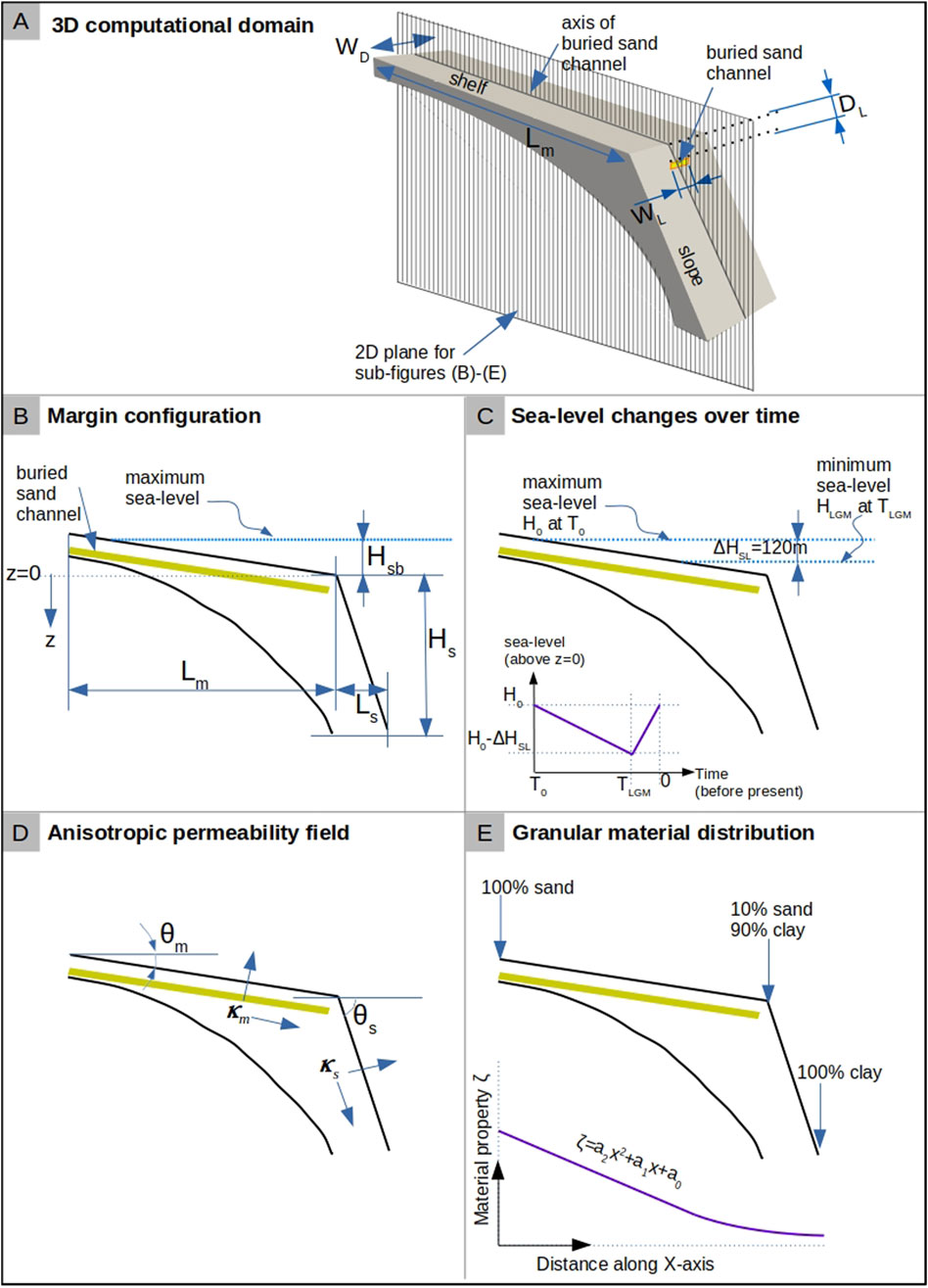
Figure 1. Computational domain and test-setting. In (A), the 3D computational domain for the idealised continental margin is shown. The margin domain contains a buried sand channel of width
The margin consists of sediment with a graded granular structure, with sand coastwards, smoothly transitioning to clay seawards (Figure 1E). The heterogeneity in the corresponding hydraulic and mechanical properties
with,
The effects of steady-state compaction on the sediment properties
where,
We consider the continental margin described here as representative of global continental margins as it preserves the following necessary features during idealization: 1) Simplified geometry has distinct shelf, shelf-break, and slope based on mean global measurements as described above; and 2) sediment properties reflect the lithological complexity through variation from coarse-grained (i.e., higher sand volume) onshore to fine-grained (i.e., higher clay volume) offshore, unconsolidated on seafloor to fully-consolidated at depth, and anisotropic permeability distribution to mimic the sediment layering during deposition and burial processes.
A buried high-permeability (sand) channel (Figures 1A, B) acts as a preferential flow pathway for groundwater flow. The thickness of this channel is assumed to be fixed (
The sea-level fluctuations during the last glacial cycle are approximated as an asymmetric hat function (Bintanja et al., 2005), shown in Figure 1C. This function is imposed on the surface (seafloor) of this continental margin with a time-period of
Annual rainfall (R) of 100 cm is assumed to act on the exposed shelf as the sea-level drops, and the meteoric recharge flux is assumed to be 25% of R based on the global mean annual rainfall and recharge rates (Moeck et al., 2020). A 2D modelling study by Micallef et al. (2023) showed that these values for annual rainfall and recharge can trigger mechanical instabilities. Sea-level changes and the meteoric recharge fluxes induce transient groundwater flow offshore. Although seasonal variations in rainfall are expected to cause local perturbations over short time scales, these perturbations will average out over a period of several thousand years. Furthermore, the groundwater recharge rates are hard to quantify as they vary substantially depending upon the geological environment, ranging from 40% in shallow aquifers of Quaternary sands to 13% and 4% in deeper aquifers of Miocene-Pliocene sandstone and weathered crystalline rocks, respectively (Kotchoni et al., 2018). Since the focus of this study is purely mechanistic, the assumption of continuous average rainfall at a moderate recharge rate is reasonable.
Table 1A lists the values of parameters in
Table 1. Material properties and model parameters.
The modelling study by Micallef et al. (2023) has shown that the permeability contrast, rather than the absolute permeability, affects mechanical stability. Therefore, within the scope of this study, testing the effect of permeability is not directly relevant to the mechanistic understanding of the relationship between OFG and evolution of landforms.
In our model, the evolution of the landscape strongly depends on the ‘relative’ magnitudes of
In total, two sets of scenarios were simulated. The first set includes nine scenarios without the buried channel for all combinations of
3 Results
In scenarios without a buried sand channel, OFG flow and seepage only generate landforms in the margin configurations with shallow shelf-break (
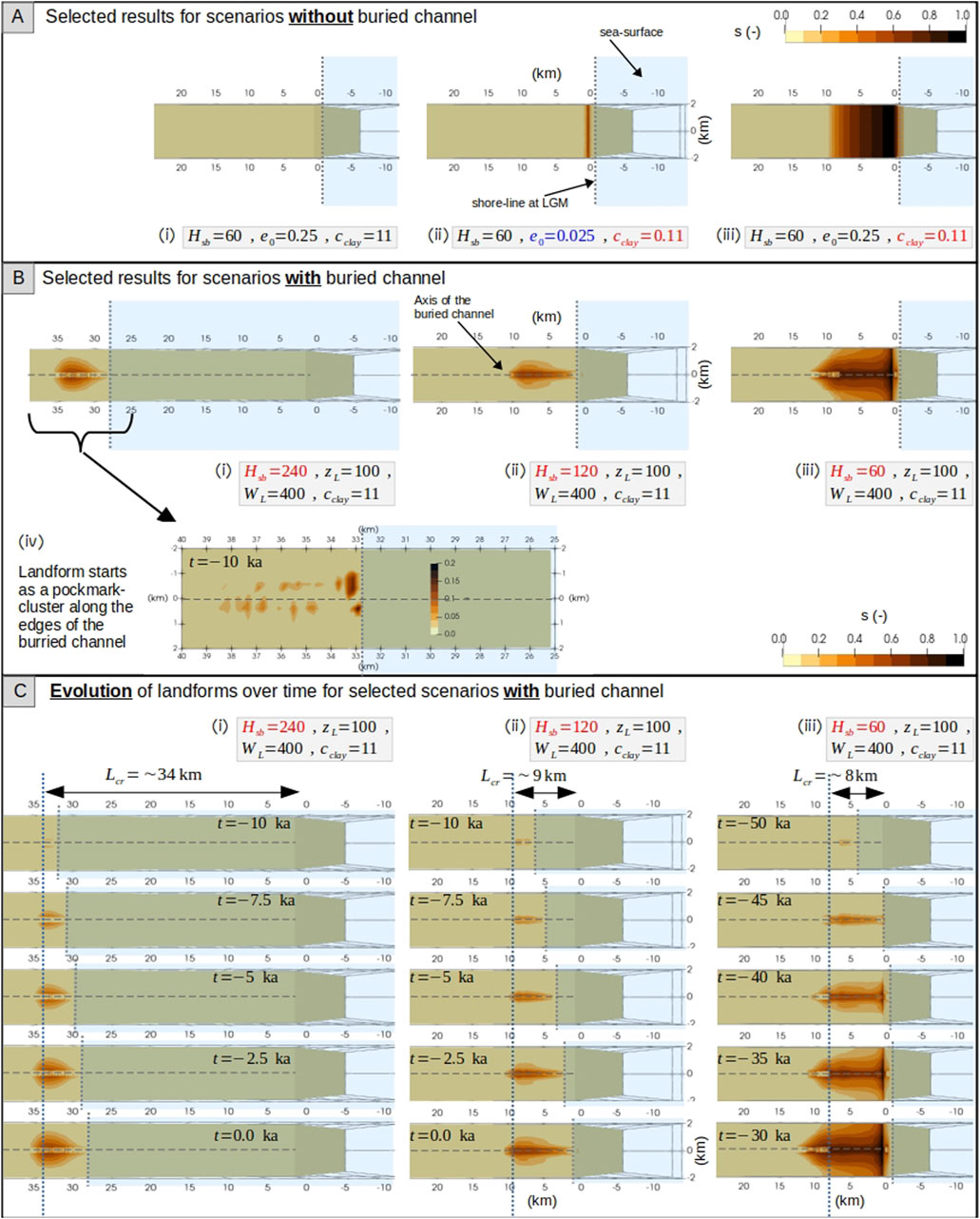
Figure 2. (A) Distribution of relative sediment volume loss
In scenarios with a buried sand channel, the depth of the shelf-break (
The size (i.e., length, width, and volume) of the landforms is controlled by the characteristics of the buried sand channel (e.g., its width
a. Impact of the buried sand channel characteristics: The buried sand channel modulates the groundwater flow field by providing a preferential flow path and thus enhances the erosion-driven sediment removal. Wider channels (
b. Impact of clay content in surface sediments: A landform can only evolve where the stress-state is unstable (i.e.,
c. Impact of cohesive strength of clay-rich sediment: The cohesion parameter controls the boundary of the failure envelope
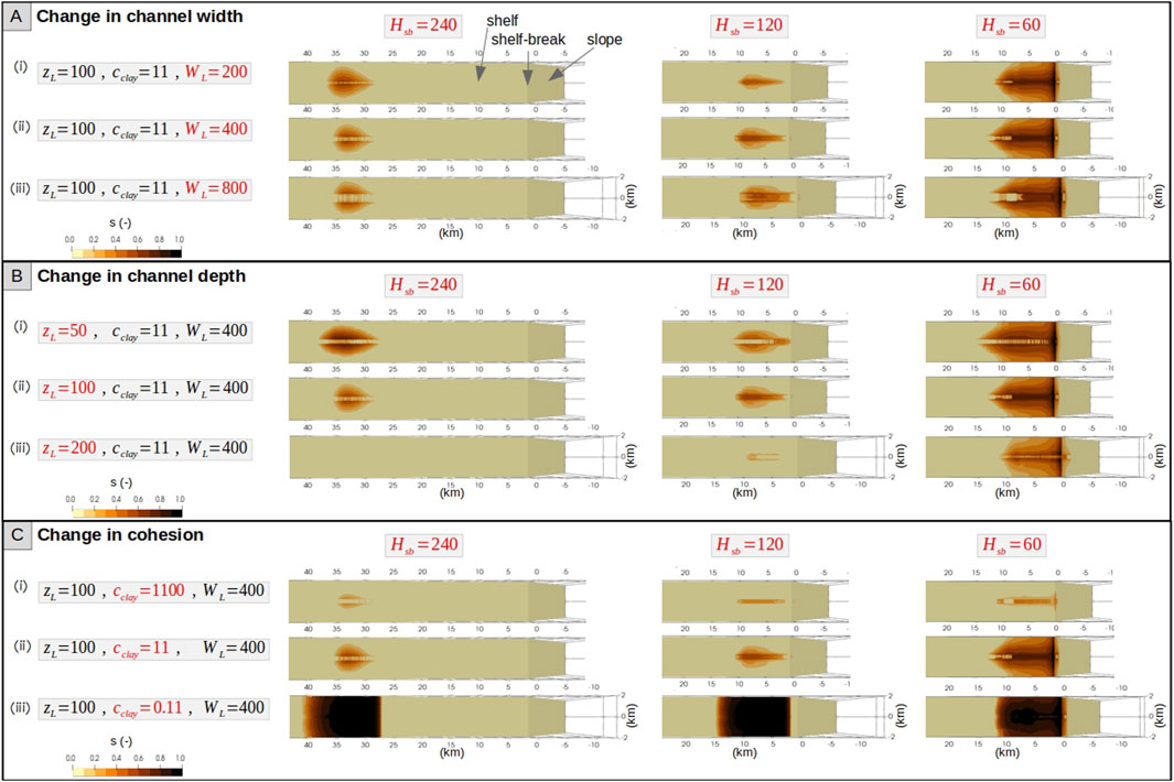
Figure 3. Snapshots of the distribution of relative sediment volume loss
4 Discussion
The depth of the shelf-break (
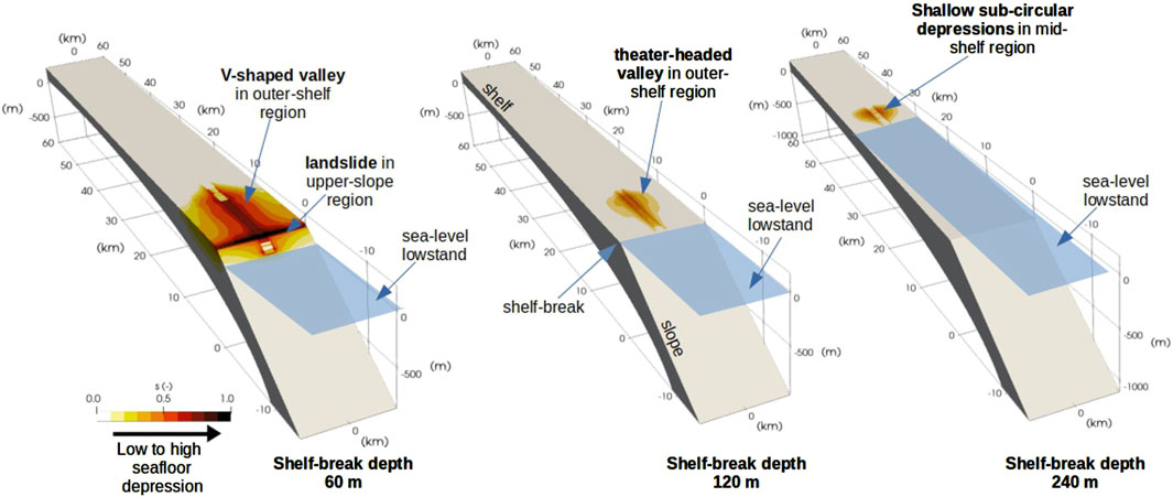
Figure 4. Schematic representation summarising the key morphological features formed by sub-seafloor OFG seepage observed across varying shelf-break depths (60 m, 120 m, and 240 m) during sea-level lowstand conditions.
4.1 Comparison with field data
We compare our simulation results with examples of mapped seafloor landforms that have been attributed to OFG activity (see Table 2 for a summary of the seafloor landform characteristics). Note that the scope of this study is limited to synthetic scenarios with a clear focus on analysing the process controls, rather than simulating the specific geological scenario for each field-analogue. Therefore, the purpose of this comparison is not to simulate the details of the particular geological settings, but to show that many field analogues support our main results vis-à-vis the role of
a. Pockmarks in the New England Mud Patch (USA) (Goff, 2019): The New England margin has a shelf gradient of
b. Shelf-indenting canyons with retrogressive slope failure at the head in Northern KwaZulu-Natal (South Africa) (Green and Uken, 2008): The KwaZulu-Natal margin has a shelf-break depth of 120 m, which corresponds to the LGM sea-level lowstand, and buried channels (Green and Garlick, 2011; Green, 2009). No clear evidence of OFG has been published for this margin, although the hydraulic head from the adjacent coastal groundwater table is thought to drive freshwater seepage offshore (Meyer et al., 2001; Green and Uken, 2008). For such a margin, our model predicts the formation of a V-shaped canyon originating at the shelf-break (e.g., Figure 2Bii and 3A,B with
c. Slope failure at the shelf-break offshore Nice (France) (Kopf et al., 2016; Stegmann et al., 2011): The Nice margin has a shelf-break depth of 100 m, which is shallower than the LGM sea-level lowstand. A sandy layer is present at shallower depth (Steiner et al., 2015). Moreover, Kopf et al. (2016) suggest that coarse-grained sediments may be located close to the shelf-break. This is consistent with our model prediction of slope failures in the upper slope and shelf-break region for margins with shallow
d. Slope failure in the upper continental slope of the Canadian Beaufort Sea (Canada) (Paull et al., 2021): The margin of the Beaufort Sea has a shelf-break depth of 110 m (slightly shallower than LGM). Here, permafrost extends to the outer continental shelf (Grob et al., 2023), and a large-scale submarine groundwater flow system is thought to be present (Frederick and Buffett, 2015). The shelf consists of a series of banks and infilled cross-shelf troughs/channels (Blasco et al., 2013). The reported slope failure in the upper slope region is consistent with our model predictions for margins with shallow
e. New Jersey margin (USA) (Brothers et al., 2014): There is extensive evidence for OFG across this margin, which was derived from drilling campaigns (Hathaway et al., 1979; Lofi et al., 2013; Mountain et al., 2010), geophysical surveys (Gustafson et al., 2019; Key, 2016) and numerical modelling (Thomas et al., 2019). The OFG system extends 90 km from the coast and is thought to have been emplaced by meteoric recharge either in modern times or at a time when climatic and hydrologic conditions were similar (Mottl and Hayashi, 2009; van Geldern et al., 2013). The New Jersey shelf has a slope gradient of
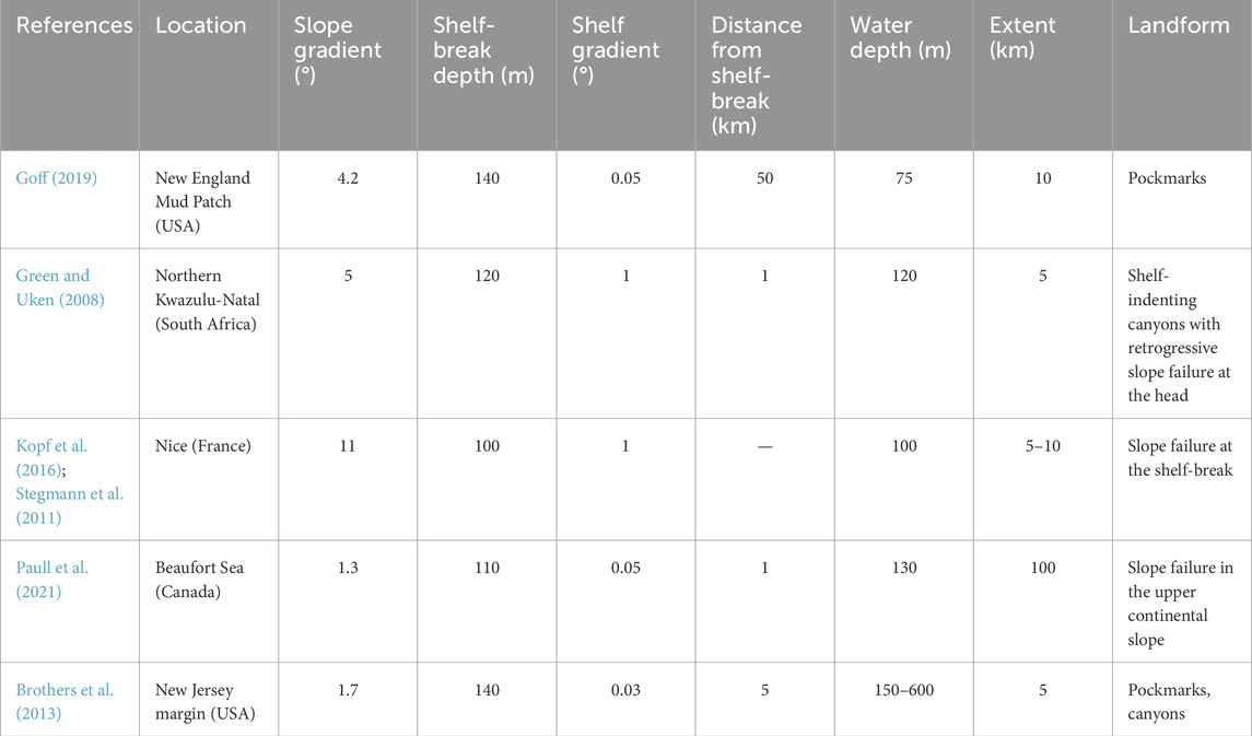
Table 2. Published examples of seafloor landforms attributed to OFG flow/seepage. The location of the landforms, their characteristics (extent, water depth, distance from shelf break) and the characteristics of the margin where they are located (shelf gradient, shelf break depth) are provided.
The available field observations, thus, support our model results in terms of the influence of the depth of the shelf-break (
It is important to recognize that various processes influencing continental margins can also contribute to the formation of the landforms described. For instance, pockmarks can result from the expulsion of different fluids, including methane, carbon dioxide, and hydrothermal fluids (Hovland et al., 2002). Slope failure may be preconditioned by factors such as rapid sediment accumulation, weak sedimentary layers, seafloor erosion, and tectonic activities. Common triggers for these failures include earthquakes, cyclic loading, and human activities (Masson et al., 2006). The development of submarine canyons is largely driven by erosion from turbidity currents, slope failures, tectonic forces, and hydrodynamic processes (Amblas et al., 2018).
4.2 Implications and limitations
In view of the above, and as long as there is a contrast between the sediment in the buried channel and the surrounding material, we expect the outcomes of our numerical simulations to be applicable to the geomorphic evolution of numerous siliciclastic passive margins globally in the last 1 Ma. We expect the applicability to extend to convergent margins, although additional factors (e.g., margin deformation, thrust faulting, overpressure generation) are likely to distort the interrelation between groundwater processes and seafloor form described here. We would expect similar types of landforms to emerge with similar controls in carbonate margins, considering that dissolution, a key process operating in such settings, is also seepage driven.
In this study, our primary focus is on understanding the basic mechanistic links between subsurface flow fields and their surface manifestations on seafloor morphology. While our motivation stems from observations in freshened groundwater systems, the broader and more fundamental question we address concerns the impact of subsurface flows—arising from meteoric and sea-level perturbations—on landform evolution at the seafloor. To explore this, we employed a simplified modelling approach that does not include solute transport or account for the effects of variable density flow. This decision was based on our objective to isolate and analyse the hydro-mechanical interactions that are most critical to the genesis of erosional features under idealized conditions. By abstracting away the complexities associated with chemical and density-driven processes, our model elucidates the primary dynamics of flow-induced erosion and its potential to drive significant geomorphic changes. This approach allows us to provide a clear demonstration of how groundwater flow, even in its simplest form, can be an independent (and possibly primary) driver of morphological evolution, thereby setting the stage for future studies to incorporate more complex interactions, including those involving solute transport and variable density flows. Our model also overlooks chemical processes (e.g., leaching, dissolution), which are likely to enhance the erosive action of OFG (e.g., Saadatkhah et al., 2023), and stratigraphic structures (e.g., clinoforms), which are known to provide heterogeneous conduits systems for groundwater flow (e.g., Gustafson et al., 2019). The model employs a simplified approach to permeability, idealizing the spatial, lithological and anisotropic variations. The model does not incorporate varying rainfall scenarios with distinct spatial and temporal characteristics. During some stages of lowstand, erosion is expected on the shelf, which we do not account for. We also do not account for the influence of rivers and the onshore drainage basin. The model for the sediment mass removal rate in Equation 10 is a special case of the more general form (Equation 15). This reduced form is helpful in characterising the qualitative features of the evolving landforms but, quantitatively, we expect the actual timing of the initiation of the landform formation and the magnitude of mass removal to be sensitive to the parameterisation of the general form. The landforms are shown in terms of relative volume loss of the sediments. While there exists a positive correlation between the sediment volume fraction (i.e., volume of sediment contained in a unit elemental volume) and height of the landform, it is not straightforward to extract this correlation due to the inherent complexity of the subsurface domain. Finally, while we could qualitatively show how the characteristics of seafloor landforms like pockmarks, canyons, and slope failures associated to OFG flow/seepage align with our model predictions, a case-by-case modelling study of these analogues will be beneficial to better constrain the model parameters and improve the understanding of additional environmental controls.
5 Conclusion
We presented a numerical study simulating the geomorphic action of OFG in an idealised 3D passive siliciclastic margin to delineate the characteristics of the resulting landforms and their main controls.
Our main findings are the following:
a. OFG can generate seafloor landforms in the presence of buried, high permeability channels.
b. These landforms are primarily erosion-controlled features that may evolve into translational slope failures in sediments with low cohesive strength.
c. Depth of the shelf-break controls the type, location, and timing of landform formation. Shelf-breaks deeper than the sea-level lowstand lead to shallow sub-circular depressions in the mid-shelf region, while shallower shelf-breaks lead to V-shaped and theatre-headed valleys in the outer shelf to upper slope region. These landforms develop during sea-level fall and initiate as pockmark clusters along the edges of the buried channel.
d. The width and depth of the buried channel affect the size of the landform, but not the type. Wider channels located at shallow depths lead to larger landforms.
e. Volume of clay in the sediments also exerts an important control. Since clay is more cohesive than sands, but has less frictional strength, it alters the failure envelope and therefore controls the location of initial failure. The higher the clay content, the farther coastwards the landform will extend.
f. Finally, we showed how the characteristics of field examples of seafloor landforms like pockmarks, canyons, and slope failures that have been associated with OFG flow/seepage align well with our model predictions.
This study establishes a clear mechanistic link between the subsurface flow of groundwater and its surface manifestations as various seafloor landforms. Our analysis also shows that the landforms are inherently transitional, i.e., they change from one type to another dynamically. By showing that the source/sink term that drives the landform evolution can be decomposed into a stress-controlled mechanical part and a flow-controlled hydraulic part, we provide a general analytical framework with which the dynamic transition of landforms can be analyzed.
Data availability statement
The source code for the model and test scenarios presented in this manuscript are archived and can be accessed as https://doi.org/10.5281/zenodo.7554639.
Author contributions
SG: Conceptualization, Formal Analysis, Investigation, Methodology, Software, Validation, Visualization, Writing–original draft. AM: Conceptualization, Funding acquisition, Investigation, Methodology, Project administration, Supervision, Validation, Writing–review and editing.
Funding
The author(s) declare that financial support was received for the research, authorship, and/or publication of this article. This project has received funding from the European Research Council (ERC) under the European Union’s Horizon 2020 research and innovation program [grant agreement No 677898 (MARCAN)]. SG acknowledges the additional support from MSCA Postdoctoral ERA Fellowships 2021 action, under the Horizon Europe program, project `WarmArctic’ number 101090338. AM was supported by the David and Lucile Packard Foundation. The work was carried out in the framework of COST (European Cooperation in Science and Technology) Action CA21112 - Offshore freshened groundwater: An unconventional water resource in coastal regions? – OFF-SOURCE.
Conflict of interest
The authors declare that the research was conducted in the absence of any commercial or financial relationships that could be construed as a potential conflict of interest.
Publisher’s note
All claims expressed in this article are solely those of the authors and do not necessarily represent those of their affiliated organizations, or those of the publisher, the editors and the reviewers. Any product that may be evaluated in this article, or claim that may be made by its manufacturer, is not guaranteed or endorsed by the publisher.
References
Amblas, D., Ceramicola, S., Gerber, T. P., Canals, M., Chiocci, F. L., Dowdeswell, J. A., et al. (2018). “Submarine canyons and gullies,” in Submarine geomorphology. Editors A. Micallef, S. Krastel, and A. Savini (Springer), 251–272.
Anderson, J. B., and Fillon, R. H. (2004). Late Quaternary stratigraphic evolution of the northern Gulf of Mexico margin.
Bintanja, R., Van de Wal, R., and Oerlemans, J. (2005). Modelled atmospheric temperatures and global sea levels over the past million years. Nature 437, 125–128. doi:10.1038/nature03975
Blasco, S., Bennett, R., Brent, T., Burton, M., Campbell, P., Carr, E., et al. (2013). 2010 state of knowledge: beaufort Sea seabed geohazards associated with offshore hydrocarbon development. Geol. Surv. Can. Offshore Geoscience Program 6989, 340. doi:10.4095/292616516
Brothers, D., Ruppel, C., Kluesner, J. W., Ten Brink, U., Chaytor, J., Andrews, B., et al. (2014). Seabed fluid expulsion along the upper slope and outer shelf of the U.S. Atlantic continental margin. Geophys. Res. Lett. 41, 96–101. doi:10.1002/2013gl058048
Brothers, L. L., Van Dover, C. L., German, C. R., Kaiser, C. L., Yoerger, D., Ruppel, C., et al. (2013). Evidence for extensive methane venting on the southeastern U.S. Atlantic margin. Geology 41, 807–810. doi:10.1130/G34217.1
Carter, M., and Bentley, S. (1991). Correlations of soil properties. London: Penetech Press Publishers.
Chaumillon, E., Tessier, B., and Reynaud, J. (2010). Stratigraphic records and variability of incised valleys and estuaries along French coasts. Bull. la Soc. Geol. Fr. 181 (2), 75–85. doi:10.2113/gssgfbull.181.2.75
Cohen, D., Person, M., Wang, P., Gable, C., Hutchinson, D., Marksamer, A., et al. (2010). Origin and extent of fresh paleowaters on the atlantic continental shelf, USA. Groundwater 48, 143–158. doi:10.1111/j.1745-6584.2009.00627.x
Dronkers, J., and van den Berg, J. (2024). Coastal and marine sediments. Coast. Wiki. Available at: http://www.coastalwiki.org/wiki/Coastal_and_marine_sediments (Accessed March 15, 2024).
Faure, H., Walter, R., and Grant, D. (2002). The coastal oasis: ice age springs on emerged continental shelves. Glob. Planet. Change 33, 47–56. doi:10.1016/s0921-8181(02)00060-7
Fielding, C., Trueman, J., Dickens, G., and Page, M. (2003). Anatomy of the buried Burdekin River channel across the Great Barrier Reef shelf: how does a major river operate on a tropical mixed siliciclastic/carbonate margin during sea level lowstand? Sediment. Geol. 157, 291–301. doi:10.1016/s0037-0738(02)00238-5
Frederick, J., and Buffett, B. (2015). Effects of submarine groundwater discharge on the present-day extent of relict submarine permafrost and gas hydrate stability on the beaufort sea continental shelf. J. Geophys. Res. Earth Surf. 120 (3), 417–432. doi:10.1002/2014jf003349
Goff, J. (2019). Modern and fossil pockmarks in the New England Mud Patch: implications for submarine groundwater discharge on the middle shelf. Geophys. Res. Lett. 46, 12213–12220. doi:10.1029/2019gl084881
Green, A. (2009). Palaeo-drainage, incised valley fills and transgressive systems tract sedimentation of the northern Kwazulu-Natal continental shelf, South Africa, SW Indian ocean. Mar. Geol. 263 (1), 46–63. doi:10.1016/j.margeo.2009.03.017
Green, A., and Garlick, G. (2011). A sequence stratigraphic framework for a narrow, current-swept continental shelf: the Durban bight, central Kwazulu-Natal, South Africa. J. Afr. Earth Sci. 60, 303–314. doi:10.1016/j.jafrearsci.2011.03.007
Green, A., and Uken, R. (2008). Submarine landsliding and canyon evolution on the northern KwaZulu-Natal continental shelf, South Africa, SW Indian Ocean. Mar. Geol. 254, 152–170. doi:10.1016/j.margeo.2008.06.001
Grob, H., Riedel, M., Duchesne, M., Krastel, S., Bustamante, J., Fabien-Ouellet, G., et al. (2023). Revealing the extent of submarine permafrost and gas hydrates in the Canadian Arctic Beaufort Sea using seismic reflection indicators. Geochem. Geophys. Geosystems 24 (5), e2023GC010884. doi:10.1029/2023gc010884
Gustafson, C., Key, K., and Evans, R. (2019). Aquifer systems extending far offshore on the U.S. Atlantic margin. Sci. Rep. 9, 8709. doi:10.1038/s41598-019-44611-7
Gwiazda, R., Paull, C., Dallimore, S., Melling, H., Jin, Y., Hong, J., et al. (2018). Freshwater seepage into sediments of the shelf, shelf edge, and continental slope of the Canadian Beaufort Sea. Geochem. Geophys. Geosystems 19, 3039–3055. doi:10.1029/2018gc007623
Hanebuth, T., Stattegger, K., and Bojanowski, A. (2009). Termination of the last glacial maximum sea-level lowstand: the sunda-shelf data revisited. Glob. Planet. Change 66, 76–84. doi:10.1016/j.gloplacha.2008.03.011
Harris, P., and Macmillan-Lawler, M. (2016). “Global overview of continental shelf geomorphology based on the SRTM30 PLUS 30-Arc second database,” in Seafloor mapping along continental shelves: research and techniques for visualizing benthic environments. Editors C. Finkl, and C. Makowski (Cham: Springer International Publishing), 169–190.
Harris, P., Macmillan-Lawler, M., Rupp, J., and Baker, E. (2014). Geomorphology of the oceans. Mar. Geol. 352, 4–24. doi:10.1016/j.margeo.2014.01.011
Hathaway, J., Poag, C., Valentine, P., Manheim, F., Kohout, F., Bothner, M., et al. (1979). U.S. geological survey core drilling on the Atlantic shelf. Science 206, 515–527. doi:10.1126/science.206.4418.515
Hommel, J., Coltman, E., and Class, H. (2018). Porosity–permeability relations for evolving pore space: a review with a focus on (bio-)geochemically altered porous media. Transp. Porous Media 124, 589–629. doi:10.1007/s11242-018-1086-2
Hovland, M., Gardner, J. V., and Judd, A. G. (2002). The significance of pockmarks to understanding fluid flow processes and geohazards. Geofluids 2, 127–136. doi:10.1046/j.1468-8123.2002.00028.x
Howard, A. D. (1988). “Groundwater sapping on Earth and Mars,” in Sapping Features of the Colorado Plateau. Editors A. D. Howard, R. C. Kochel, and H. R. Holt (NASA), 1–4.
Howard, A. D., and McLane, C. F. (1988). Erosion of cohesionless sediment by groundwater seepage. Water Resour. Res. 24 (10), 1659–1674. doi:10.1029/WR024i010p01659
Jiang, X.-W., Wang, X.-S., and Wan, L. (2010). Semi-empirical equations for the systematic decrease in permeability with depth in porous and fractured media. Hydrogeology J. 18, 839–850. doi:10.1007/s10040-010-0575-3
Johnson, D. (1939). The origin of submarine canyons: a critical review of hypotheses. New York: Columbia University Press.
Key, K. (2016). MARE2DEM: a 2-D inversion code for controlled-source electromagnetic and magnetotelluric data. Geophys. J. Int. 207 (1), 571–588. doi:10.1093/gji/ggw290
Kohout, F. (1964). “The flow of fresh water and salt water in the Biscayne aquifer of the Miami area, Florida,” in Sea water in coastal aquifers: relation of salt water to fresh groundwater. Editors H. Cooper, K. F. A., H. Henry, and R. Glover (Reston, VA: USGS Water supply), C12–C33.
Kong, X., Liu, J., Du, Y., Wen, C., and Xu, G. (2011). Seismic geomorphology of buried channel systems in the western South Huanghai sea: retrodiction for paleo-environments. Acta Oceanol. Sin. 30 (1), 47–58. doi:10.1007/s13131-011-0090-y
Kooi, H., and Groen, K. (2001). Offshore continuation of coastal groundwater systems; predictions using sharp-interface approximations and variable-density flow modelling. J. Hydrology 246, 19–35. doi:10.1016/s0022-1694(01)00354-7
Kopf, A., Stegmann, S., Garziglia, S., Henry, P., Dennielou, B., Haas, S., et al. (2016). Soft sediment deformation in the shallow submarine slope off Nice (France) as a result of a variably charged Pliocene aquifer and mass wasting processes. Sediment. Geol. 344, 290–309. doi:10.1016/j.sedgeo.2016.05.014
Kotchoni, D. O. V., Vouillamoz, J. M., Lawson, F. M. A., Adjomayi, P. A., Boukari, M., and Taylor, R. G. (2018). Relationships between rainfall and groundwater recharge in seasonally humid Benin: a comparative analysis of long-term hydrographs in sedimentary and crystalline aquifers. Hydrogeology J. 27, 447–457. doi:10.1007/s10040-018-1806-2
Kulhawy, F., and Mayne, P. (1990). Manual on estimating soil properties for foundation design. Palo Alto, California: Electric Power Research Institute.
Lericolais, G., Auffret, J.-P., and Bourillet, J.-F. (2003). The Quaternary channel river: seismic stratigraphy of its palaeo-valleys and deeps. J. Quat. Sci. 18, 245–260. doi:10.1002/jqs.759
Lindeburg, M. (2001). Civil engineering reference manual for the PE exam. Belmont, California: Professional Publications.
Lofi, J., Inwood, J., Proust, J., Monteverde, D., Loggia, D., Basile, C., et al. (2013). Fresh-water and salt-water distribution in passive margin sediments: insights from integrated ocean drilling program expedition 313 on the New Jersey margin. Geosphere 9 (4), 1009–1024. doi:10.1130/ges00855.1
Masson, D. G., Harbitz, C. B., Wynn, R. B., Pedersen, G., and Løvholt, F. (2006). Submarine landslides: processes, triggers and hazard prediction. Philosophical Transaction R. Soc. 364, 2009–2039. doi:10.1098/rsta.2006.1810
McMaster, R., and Ashraf, A. (1973). Drowned and buried valleys on the southern New England continental shelf. Mar. Geol. 15 (4), 249–268. doi:10.1016/0025-3227(73)90073-x
Menier, D., Estourn`es, G., Mathew, M., Ramkumar, M., Briend, C., Siddiqui, N., et al. (2016). Relict geomorphological and structural control on the coastal sediment partitioning, north of Bay of Biscay. Z. F. ̈ur Geomorphol. 60 (1), 67–74. doi:10.1127/zfg/2016/0267
Menier, D., Tessier, B., Proust, J., Baltzer, A., Sorrel, P., and Traini, C. (2010). The Holocene transgression as recorded by incised-valley infilling in a rocky coast context with low sediment supply (southern Brittany, western France). Bull. la Soc. Geol. Fr. 181, 115–128. doi:10.2113/gssgfbull.181.2.115
Meyer, R., Talma, A., Duvenhage, A., Eglington, B., Taljaard, J., Botha, J., et al. (2001). Geohydrological investigation and evaluation of the Zululand coastal aquifer. Water Res. Comm. 51.
Micallef, A., Person, M., Berndt, C., Bertoni, C., Cohen, D., Dugan, B., et al. (2021). Offshore freshened groundwater in continental margins. Rev. Geophys. 59, e2020RG000706. doi:10.1029/2020rg000706
Micallef, A., Person, M., Gupta, S., Saadatkhah, N., Camille, A., and Gratacós, Ò. (2023). Can offshore meteoric groundwater generate mechanical instabilities in passive continental margins? Geophysical Research. Earth Surf. 128. doi:10.1029/2022JF006954
Micallef, A., Person, M., Haroon, A., Weymer, B., Jegen, M., Schwalenberg, K., et al. (2020). 3D characterisation and quantification of an offshore freshened groundwater system in the Canterbury Bight. Nat. Commun. 11, 1372. doi:10.1038/s41467-020-14770-7
Moeck, C., Grech-Cumbo, N., Podgorski, J., Bretzler, A., Gurdak, J. J., Berg, M., et al. (2020). A global-scale dataset of direct natural groundwater recharge rates: a review of variables, processes and relationships. Sci. Total Environ. 717, 137042. doi:10.1016/j.scitotenv.2020.137042
Morrissey, S., Clark, J., Bennett, M., Richardson, E., and Stute, M. (2010). Groundwater reorganization in the Floridan aquifer following Holocene sea-level rise. Nat. Geosci. 3, 683–687. doi:10.1038/ngeo956
Mottl, M., and Hayashi, T. (2009). Fresh and salty: chemistry of sediment pore water from the New Jersey shallow shelf: IODP Exp 313. San Francisco: AGU Fall Meeting.
Mountain, G., Proust, J., McInroy, D., and Cotterill, C. (2010). “Expedition 313 scientists,” in Proceedings of the integrated ocean drilling program.
Mulligan, A. E., Evans, R. L., and Lizarralde, D. (2007). The role of paleochannels in groundwater/seawater exchange. J. Hydrology 335, 313–329. doi:10.1016/j.jhydrol.2006.11.025
Nordfjord, S., Goff, J., Austin, Jr. J., Gulick, S., and Galloway, W. (2006). Seismic facies of incised-valley fills, New Jersey continental shelf: implications for erosion and preservation processes acting during latest pleistocene-holocene transgression. J. Sediment. Res. 76, 1284–1303. doi:10.2110/jsr.2006.108
Nordfjord, S., Goff, J., Austin, Jr. J., and Sommerfield, C. (2005). Seismic geomorphology of buried channel systems on the New Jersey outer shelf: assessing past environmental conditions. Mar. Geol. 214, 339–364. doi:10.1016/j.margeo.2004.10.035
Paull, C., Dallimore, S., Caress, D., Gwiazda, R., Lundsten, E., Anderson, K., et al. (2021). A 100-km wide slump along the upper slope of the Canadian Arctic was likely preconditioned for failure by brackish pore water flushing. Mar. Geol. 435, 106453. doi:10.1016/j.margeo.2021.106453
Person, M., Dugan, B., Swenson, J., Urbano, L., Stott, C., Taylor, J., et al. (2003). Pleistocene hydrogeology of the atlantic continental shelf, New England. Geol. Soc. Am. Bull. 115, 1324–1343. doi:10.1130/b25285.1
Pilcher, R., and Argent, J. (2007). Mega-pockmarks and linear pockmark trains on the West African continental margin. J. Petroleum Eng. 244 (1–4), 15–32. doi:10.1016/j.margeo.2007.05.002
Post, V., Groen, J., Kooi, H., Person, M., Ge, S., and Edmunds, W. (2013). Offshore fresh groundwater reserves as a global phenomenon. Nature 504, 71–78. doi:10.1038/nature12858
Rahmati, H., Jafarpour, M., Azadbakht, S., Nouri, A., Vaziri, H., and Chan, D. (2013). Review of sand production pediction models. J. Pet. Eng. 2013, 864981.
Rutqvist, J., Wu, Y.-S., Tsang, C.-F., and Bodvarsson, G. (2002). A modeling approach for analysis of coupled multiphase fluid flow, heat transfer, and deformation in fractured porous rock. Int. J. Rock Mech. Min. Sci. 39 (4), 429–442. doi:10.1016/S1365-1609(02)00022-9
Saadatkhah, N., Kassim, A., Siat, Q. A., and Micallef, A. (2023). Salt leaching by freshwater and its impact on seafloor stability: an experimental investigation. Mar. Geol. 455, 106959. doi:10.1016/j.margeo.2022.106959
Sander, O. (2020). DUNE — The Distributed and Unified Numerics Environment. Switzerland: Springer Nature, 616.
Siegel, J., Person, M., Dugan, B., Cohen, D., Lizarralde, D., and Gable, C. (2014). Influence of late Pleistocene glaciations on the hydrogeology of the continental shelf offshore Massachusetts, USA. Geochem. Geophys. Geosystems 15, 4651–4670. doi:10.1002/2014gc005569
Stegmann, S., Sultan, N., Kopf, A., Apprioual, R., and Pelleau, P. (2011). Hydrogeology and its effect on slope stability along the coastal aquifer of Nice, France. Mar. Geol. 280, 168–181. doi:10.1016/j.margeo.2010.12.009
Steiner, A., Kopf, A. J., Henry, P., Stegmann, S., Apprioual, R., and Pelleau, P. (2015). Cone penetration testing to assess slope stability in the 1979 Nice landslide area (Ligurian Margin, SE France). Mar. Geol. 369, 162–181. doi:10.1016/j.margeo.2015.08.008
Sydow, C. (1988). “Stratigraphic control of slumping and canyon development on the continental margin, east coast, South Africa,”, 55. Cape Town: Department of Geological Sciences, University of Cape Town.
Thomas, A., Reiche, S., Riedel, M., and Clauser, C. (2019). The fate of submarine fresh groundwater reservoirs at the New Jersey shelf, USA. Hydrogeology J. 27, 2673–2694. doi:10.1007/s10040-019-01997-y
Traini, C., Menier, D., Proust, J., and Sorrel, P. (2013). Transgressive systems tract of a ria-type estuary: the Late Holocene Vilaine River drowned valley (France). Mar. Geol. 337, 140–155. doi:10.1016/j.margeo.2013.02.005
van Geldern, R., Hayashi, T., Bottcher, M., Mottl, M., Barth, J., and Stadler, S. (2013). Stable isotope geochemistry of pore waters and marine sediments from the New Jersey shelf: methane formation and fluid origin. Geosphere 9 (1), 96–112. doi:10.1130/GES00859.1
Virtasalo, J., Schr ̈oder, J., Luoma, S., Majaniemi, J., Mursu, J., and Scholten, J. (2019). Submarine groundwater discharge site in the First Salpausselk ̈a ice-marginal formation, south Finland. Hydrology Earth Syst. Sci. 10, 405–423. doi:10.5194/hess-2018-507
Wallmann, K., Pinero, E., Burwicz, E., Haeckel, M., Hensen, C., Dale, A., et al. (2012). The global inventory of methane hydrate in marine sediments: a theoretical approach. Energies 5 (7), 2449–2498. doi:10.3390/en5072449
Keywords: offshore freshened groundwater, topographically driven flow, landscape evolution modelling, pockmark, canyon, landslide, continental margin, numerical modelling
Citation: Gupta S and Micallef A (2025) Numerical modelling of erosional landforms driven by offshore groundwater flow on siliciclastic continental margins: a conceptual approach. Front. Earth Sci. 13:1453255. doi: 10.3389/feart.2025.1453255
Received: 22 June 2024; Accepted: 08 January 2025;
Published: 31 January 2025.
Edited by:
Valerio Acocella, Roma Tre University, ItalyReviewed by:
Dimitris Sakellariou, Hellenic Centre for Marine Research (HCMR), GreeceAleksandar Valjarević, University of Belgrade, Serbia
Copyright © 2025 Gupta and Micallef. This is an open-access article distributed under the terms of the Creative Commons Attribution License (CC BY). The use, distribution or reproduction in other forums is permitted, provided the original author(s) and the copyright owner(s) are credited and that the original publication in this journal is cited, in accordance with accepted academic practice. No use, distribution or reproduction is permitted which does not comply with these terms.
*Correspondence: Aaron Micallef, YW1pY2FsbGVmQG1iYXJpLm9yZw==