 Biao Peng
 Zhengjian Xu
 Xiaowan Chen1,7
 Yonghua Zhao
94% of researchers rate our articles as excellent or good
Learn more about the work of our research integrity team to safeguard the quality of each article we publish.
Find out more
ORIGINAL RESEARCH article
Front. Earth Sci., 16 April 2024
Sec. Geochemistry
Volume 12 - 2024 | https://doi.org/10.3389/feart.2024.1390039
This article is part of the Research TopicUnconventional Resources: Provenance Analysis, Sediment Transport, Reservoir Evaluation, Geo-energyView all 29 articles
The significance of beach-bar reservoirs, which are intricately linked to unconventional hydrocarbon reservoirs, has gained increased attention. This study elucidates the complex mechanisms governing the formation, spatial distribution, and morphological characteristics of beach bars in Qinghai Lake, NW China, highlighting the interplay of lake-level fluctuations, wind wave dynamics, sediment provenance, and terrain gradient. Our findings reveal that large-scale lake-level fluctuations primarily dictate the initial formation settings of beach bars, while small-scale fluctuations refine their internal stratification and sedimentary features. Wind wave dynamics play a critical role in defining suitable depth zones for beach bar development, influencing their morphology and resulting in distinct sedimentary characteristics across different lake zones. Furthermore, the study categorizes beach bars into three main systems based on sediment provenance—bedrock, alluvial fan (fan delta), and braided river systems—each exhibiting unique compositional and structural attributes. Terrain gradient around the lake significantly affects beach bar formation, with areas having a gradient less than 0.7° being particularly favorable. This research advances our understanding of lacustrine beach bar dynamics, offering insights into their potential as indicators of past environmental conditions and their implications for hydrocarbon exploration. The comprehensive analysis of controlling factors provides a foundation for predicting beach bar distribution and contributes to the broader field of sedimentary geology by integrating multi-disciplinary approaches to study lacustrine sedimentary processes.
Beach bar sandstones, predominantly found in shore and shallow lake areas (Wu, 1986; Zhu, 2008; Jiang, 2009), have become increasingly significant in the context of oil and gas exploration due to their association with subtle hydrocarbon reservoirs (Ji et al., 2013; Shang et al., 2014a; Zhao et al., 2014). These reservoirs are distinguished by their favorable geological conditions, such as proximity to oil sources, substantial storage capacity, and well-organized source-reservoir-cap assemblages, making them potential sites for large oil and gas fields (Ji et al., 2013; Shang et al., 2014a; Zhao et al., 2014). Recent breakthroughs in exploring beach-bar hydrocarbon reservoirs across various geological periods and basins underscore their importance. Noteworthy examples include discoveries in the lower Cretaceous of the Chepaizi area in the Junggar basin (Zhao et al., 2014), the Paleogene in the Gaoyou sag of the Subei basin (Zhu et al., 1994; Ji et al., 2013), and the Middle Permian in the north-central part of the Yishan slope of the Ordos Basin (Yang et al., 2007), with the Paleogene Shahejie Formation in the Dongying sag of the Bohai Bay basin being a significant example (Hongwen et al., 2011; Jiang et al., 2011).
A thorough understanding of the distribution and controlling factors of beach bars is essential for predicting the distribution of beach bar sandstone and for the restoration of paleoenvironment and paleoclimate, critical aspects of oil and gas exploration. Although current research has extensively examined the structural, landform, sequence, water depth, and provenance factors of beach bars (Shang et al., 2014b; Liu Q. H. et al., 2015; Jiang et al., 2015), it has primarily focused on ancient lacustrine basin beach bars, with modern lacustrine basin beach bars receiving less attention. The exploration of ancient lacustrine beach bars, relying on seismic, well logging, rock core data, and other methods, contrasts with the direct measurement approach possible in modern lacustrine basins, offering a more intuitive understanding and the opportunity to refine the research framework.
Qinghai Lake, the largest saline lake in China, located in the northeastern part of the Qinghai-Tibet Plateau, serves as an invaluable natural laboratory for studying lacustrine sedimentary processes. The lake’s beach bars, due to their relevance to understanding lacustrine dynamics, sedimentary environments, and potential climate change implications, have garnered significant research interest. Early studies provided foundational insights into the sedimentary structures and compositions of beach bars, highlighting their significance as indicators of lake-level fluctuations and sediment supply dynamics. Later research expanded these findings through geomorphological and sedimentological analyses to map beach bar distribution and infer past hydrological conditions (Wang et al., 2001; Zhou and Li, 2005).
Recent investigations have shifted towards a multi-scale analysis of beach bars, integrating sedimentological data with geophysical surveys and remote sensing techniques. Ground-penetrating radar (GPR) studies have unveiled the complex internal structures of beach bars, linking their episodic growth phases to climatic oscillations. Additionally, the assessment of wind regimes and wave energy’s impact on beach bar spatial variability has underscored the significant influence of prevailing winds on their orientation and morphology (Zhang et al., 2010; Li, 2015).
Our comprehensive research, encompassing extensive field surveys, profile analysis, and indoor analysis, has elucidated the distribution patterns and controlling factors of beach bars in Qinghai Lake. These findings not only advance our understanding of paleogeomorphology and paleoclimate but also have practical implications for predicting beach-bar reservoir distribution in oil and gas exploration, thereby bridging the gap between theoretical research and applied geoscience.
Qinghai Lake, the largest inland brackish lake in China, is situated on the northeast margin of the Qinghai-Tibet Plateau, located between 99°36′E to 100°47′E and 36°32′N to 37°15′N (Chinese Academy of Sciences, 1979). The lake is encircled by the Datong Mountain, Riyue Mountain, and Qinghai South Mountain, which together delineate a closed inland fault basin that stretches from northwest to southeast. This basin exhibits a gradual decline in altitude from northwest to southeast (Chinese Academy of Sciences, 1979).
The lake spans approximately 4,264–4,473 km2, with its long axis extending about 106 km in a near east-west direction and its horizontal axis about 63 km in a near south-north direction, resulting in an elliptical shape. The orientation of the long axis is approximately NWW 315°, making the lake surface elongated from east to west. Qinghai Lake’s elevation ranges from 3,193 m to 3,198 m above sea level, with a circumference of around 360 km. The average depth of the lake is 21 m, with the deepest point reaching up to 32 m. The total volume of the lake exceeds 100 × 10⁹ m³ (Chinese Academy of Sciences, 1979; An et al., 2006) (Figure 1).
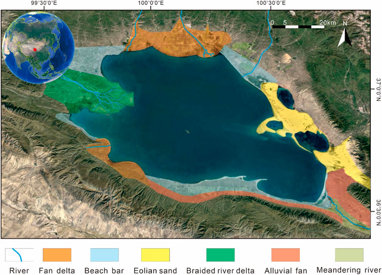
Figure 1. The distribution of sedimentary facies around The Qinghai Lake.
Based on the field investigation of the Qinghai Lake, the authors have carried out the elaborate dissection of profile sections around the Qinghai Lake. Except for the profile sections, forming beach-bars in the Qinghai Lake had been used to investigate the formation mechanisms of beach-bar sedimentary succession. Through the application of remote sensing technology and extensive field research at Qinghai Lake, a comprehensive survey identified a significant presence of beach-bar deposits around the northeast, southeast, south, southwest, and northwest margins of the lake (Figure 1). Notably, the highest altitude recorded for these beach bars reached 3,215 m.
The grain size distribution was measured by a Malvern 3000 laser diffraction instrument at the State Key Laboratory of Petroleum Resources and Engineering, China. The sorting and skewness are based on (Folk 1966) equation (Folk, 1966), where:
here,
In the northeast and southern margins of Qinghai Lake, a distinctive pattern of beach-bar deposits has been observed. These deposits, which run parallel to the lake’s shoreline, predominantly consist of small to semi-closed lagoons, as well as cross-shore deposits, indicating a varied depositional environment influenced by the lake’s dynamics. Conversely, the beach-bar deposits identified along the southwest and northwest margins are characterized by their lack of significant topographic uplift, with a relatively lower incidence of lagoons and cross-shore deposits (Figure 1). This suggests a more uniform depositional environment in these areas.
Meanwhile, the southeastern margin of Qinghai Lake showcases a different pattern, where beach-bar deposits also align parallel to the shoreline. However, in this region, the deposits primarily form completely enclosed lagoons and cross-shore deposits. This variation underscores the influence of local topographical and hydrodynamic conditions on the formation and distribution of beach-bar deposits around Qinghai Lake (Figure 1).
Lake-level fluctuation plays a pivotal role in determining the characteristics and distribution of beach-bar deposits. These fluctuations can be categorized into two types: large-scale and small-scale. For the purposes of this research, the distinction between large-scale and small-scale fluctuations is based on the extent of horizontal migration of the lake shoreline, with 150 m serving as the threshold. Specifically, fluctuations resulting in a shoreline migration greater than 150 m are considered large-scale, while those causing migration less than 150 m are deemed small-scale. The choice of 150 m as the cutoff is grounded in the observation that the width of beach-bar deposits in Qinghai Lake typically does not exceed this dimension. Meanwhile, the topographic slope of Qinghai Lake was about 0.5°, and the extent of horizontal migration of the lake shoreline, 150 m, was just the average wave base of Qinghai Lake, about 1.5 m. As a result, large-scale lake-level fluctuations can lead to the development of independent beach bars, so taking 150 m as the threshold.
Large-scale lake-level fluctuations primarily influence the location where beach bars develop. In contrast, small-scale fluctuations play a crucial role in shaping the internal structure and superimposed styles of beach bars. This distinction is crucial for understanding the formation and evolution of beach bars in response to varying lake levels. Examples in the subsequent sections will provide detailed illustrations of how these two types of fluctuations exert their control over beach-bar development and characteristics.
Recent advancements in research methods have enriched our understanding of Qinghai Lake’s lake-level fluctuations. A series of studies have contributed to this body of knowledge:
Zhang et al. (1988) and Zhang et al. (1994) utilized stable isotopes and trace elements in Ostracoda from Qinghai Lake’s core samples to infer water level fluctuations over the past 12,000 years.
Yuan et al. (1990) categorized Qinghai Lake’s development history into three epochs based on ancient shoreline data, geomorphologic characteristics, the neotectonic framework, and limited carbon isotope dating: the maximal epoch of the Middle Pleistocene, the stable epoch of the late Pleistocene, and the contraction epoch of the Holocene.
Chen et al. (1990) and Lister et al. (1991) proposed that the highest lake levels since the Holocene, approximately 13 m above current levels, occurred between 7.4 kyr and 6 kyr, based on seismic and shallow drilling data analysis.
Yu and Kelts (2002), through core sample analysis and 14C dating, discovered that the lake level was nearly dry in the early Holocene.
Madsen et al. (2008), Liu et al. (2010), Rhode et al. (2010), Liu et al. (2011), and Liu X. J. et al. (2015) reconstructed ancient lake shoreline fluctuations using optically stimulated luminescence (OSL) dating of sand deposits and eolian loess around Qinghai Lake.
Liu et al. (2013) examined the organic carbon isotopic composition of aquatic and terrestrial plants and sediments in and around Qinghai Lake. By comparing these with drilling well data, it was concluded that the lake level was low in the early Holocene.
These diverse methodologies and objectives have led to varied analyses and interpretations of Qinghai Lake’s lake-level fluctuations across different periods. Despite this, there has been a concerted effort to study the continuous fluctuation of Qinghai Lake’s levels since nearly 18,000 years ago. This paper critiques the strengths and weaknesses of previous studies, incorporating published dating data and other relevant evidence, to reconstruct the lake-level fluctuation curve of Qinghai Lake over this period.
The sediment dating data from Qinghai Lake, alongside the spatial positioning of the samples, allowed for a categorization into four distinct types: shore or shallow water deposits, loess or eolian deposits, nearshore deposits, and deep lacustrine deposits. These categories were then visually represented in a scatter diagram. Utilizing the spatial relationships among these data types, we reconstructed the plane up-down curve of Qinghai Lake’s water level since 18 kyr (as shown in Figure 2).
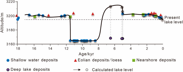
Figure 2. Lake level change curve since the last 18 kyr.
The reconstructed curve reveals that the water level of Qinghai Lake generally fluctuated around an elevation of 3,200 m from 18 kyr to 11.7 kyr. This period was characterized by a stable lake level, during which a significant number of beach-bar deposits formed at this elevation. The research of Liu et al. (2011) and Liu X. J. et al. (2015) supports this finding, having identified numerous beach bars from this timeframe that were approximately 6 m above the current lake level, as determined through OSL dating.
Between 11.7 kyr and 8 kyr, the lake experienced a general decline in water level, reaching a low point near 3,165 m above sea level in the early Holocene. This was a critical juncture where the lake almost dried up, only for the water level to experience a rapid ascent to a relatively high level between 8 kyr and 7 kyr.
The period from 8 kyr to 5 kyr saw a swift rise in the lake level from 3,165 m to 3,212 m. The analyses of shallow drilling data and ostracod shell analysis concluded that this was a high-water period for Qinghai Lake since the Holocene, with levels reaching approximately 18 m above the present day (Zhang et al., 1988; Zhang et al., 1994). This assessment was corroborated by Chen et al. (1990), Lister et al. (1991), and Wang and Shi (1992), who all agreed that the lake level reached its peak since the Holocene during this interval.
Between 5 kyr and 2.5 kyr, OSL dating of shore and nearshore deposits showed that the lake level experienced fluctuations around 3,202 m.
Over the last 2.5 kyr, the trend was generally towards a reduction in lake level, with a period of stability around 3,202 m observed from 2.5 kyr to 1.5 kyr, followed by a more accelerated decline.
Beach bars, essential features along the shoreline of Qinghai Lake, are directly influenced by lake-level fluctuations. These fluctuations dictate the migration of the shoreline, thereby determining the positioning of beach-bar development. Despite the tectonic stability of Qinghai Lake since 18 kyr, its water level has experienced significant changes, which have been a primary driver in the distribution of beach bars. This text outlines the evolution of beach bars at Qinghai Lake over four distinct stages, using continuous measurements from Yilangjian as a case study (Figure 3).
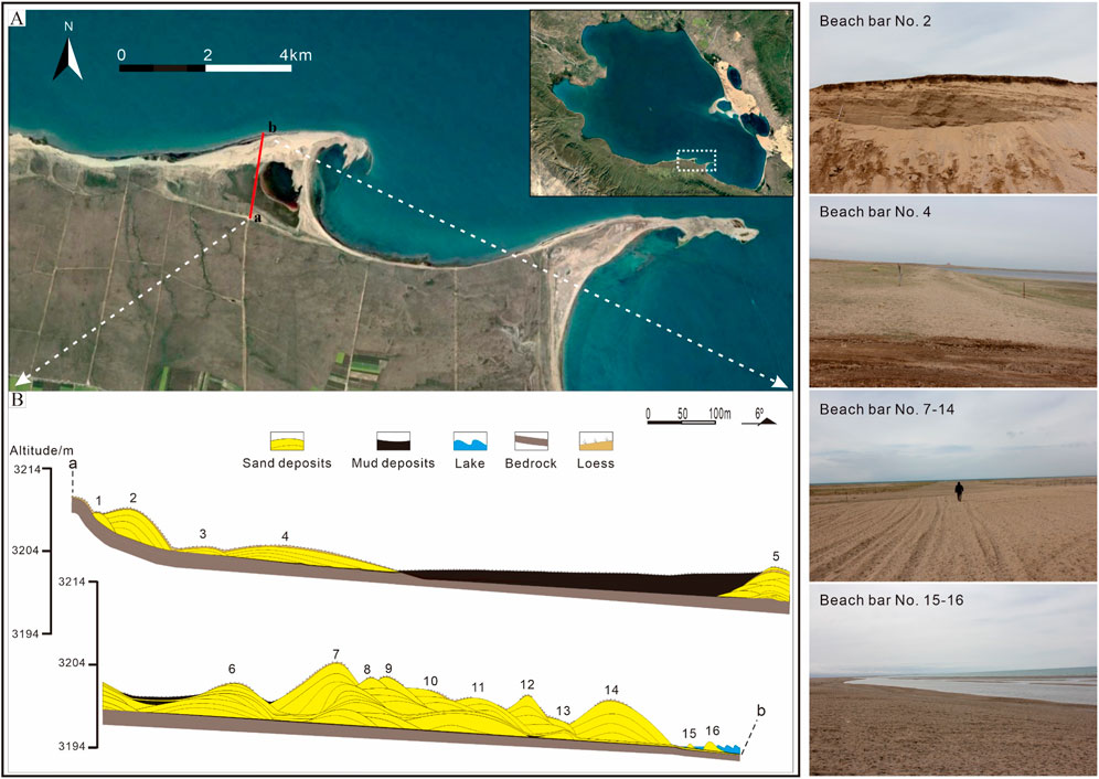
Figure 3. Distribution of beach-bars along the survey line in the Yilangjian of the Qinghai Lake. (A) for the satellite photograph of Yilangjian; (B) for the distribution diagram of beach-bars along the survey line.
During this period, Qinghai Lake’s elevation ranged from 3,197 m to 3,202 m, approximately 3–8 m above the current lake level, over a span of about 6 kyr. The climate transitioned from dry and cold to warm and wet, leading to increased monsoon precipitation (Zeng, 2007). With ample material supply and gentle terrain, beach-bar deposits formed at elevations between 3,197 m and 3,202 m. Fluctuating lake levels resulted in the formation of lagoon deposits behind the beach bars in less elevated areas (Figure 4).
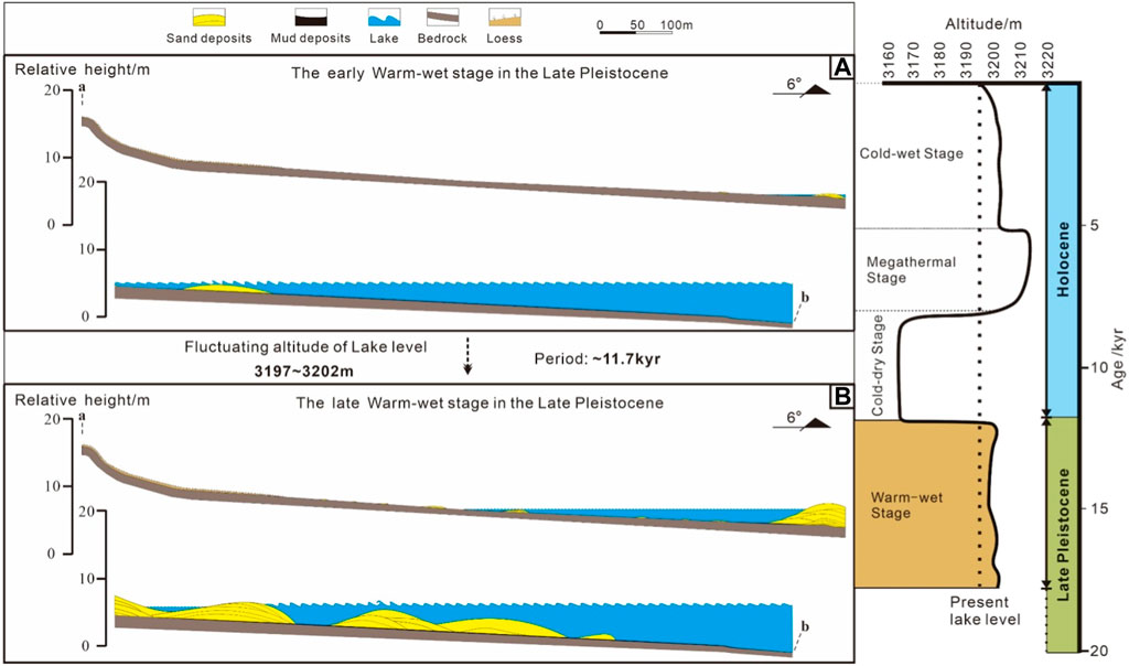
Figure 4. Diagrams showing the first-stage evolution at the Yilangjian profile. (A) for the early Warm-wet stage in the Late Pleistocene; (B) for the late Warm-wet stage in the Late Pleistocene.
At this stage, the lake’s elevation dropped to 3,165 m, about 30 m below the current level, nearly drying up. The climate was characterized by dry and cold conditions (Zhao et al., 2009), leading to a lack of beach-bar deposits. Instead, extensive loess and lagoon deposits developed across the basin (Figure 5) (Liu et al., 2003; Zeng, 2007; Zhao et al., 2009).
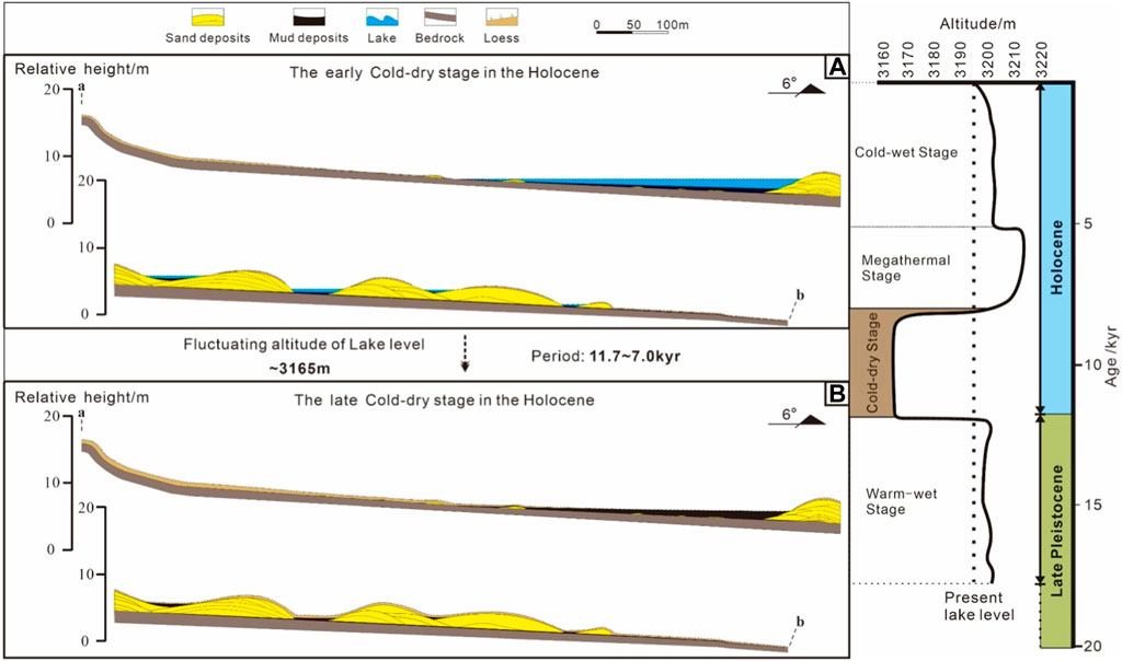
Figure 5. Diagrams showing the second-stage evolution at the Yilangjian profile. (A) for the early Cold-dry stage in the Holocene; (B) for the late Cold-dry stage in the Holocene.
This middle Holocene stage saw the peak monsoon intensity at Qinghai Lake, resulting in significant water recharge and a rapid rise in lake level. From a nearly dry state, the lake level surged to about 18 m above the current level, reaching its highest point at 3,212 m since the Holocene (Zhang et al., 1994). Consequently, beach bars formed at this elevation, marking the furthest development from the current lake level (Figure 6).
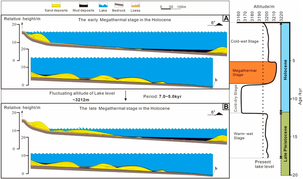
Figure 6. Diagrams showing the third-stage evolution at the Yilangjian profile. (A) for the early Megathermal stage in the Holocene; (B) for the late Megathermal stage in the Holocene.
This final stage is divided into two phases. From 5 kyr to 2.5 kyr, the climate alternated between cool-wet and warm-dry (Zhang et al., 1994), with the lake level dropping rapidly from its peak in the Megathermal Stage to stabilize around 3,200 m. From 2.5 kyr onwards, the climate shifted towards cool-dry (Zhang et al., 1994), and the lake level’s decline rate accelerated. Beach bars formed during this stage, along with those from the late Pleistocene, became composite beach bars. The receding lake level led to the development of lagoon deposits behind the bars. Over time, as the water evaporated, these lagoons became shallower, resulting in the formation of typical wet deposits seen today. Modifications in the lake level also led to the creation of small lagoons and alluvial fan deposits within the composite beach bars (Figure 7).
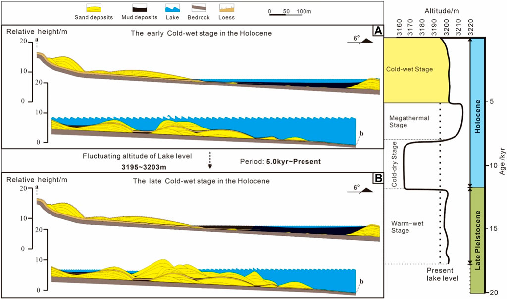
Figure 7. Diagrams showing the fourth-stage evolution at the Yilangjian profile. (A) for the early Cold-wet stage in the Holocene; (B) for the late Cold-wet stage in the Holocene.
Small-scale fluctuations in lake level have triggered the lateral migration of various facies zones within the beach-bar system, including the swash zone, breaker zone, and washover zone. This migration critically influences the vertical stacking relationships among these facies zones, which in turn dictates the overall stacking patterns of depositional units within the beach-bar. Such dynamics are essential in understanding the internal architecture of beach-bar systems.
Moreover, the internal stratification patterns within beach bars are influenced not only by small-scale lake-level fluctuations but also by the dynamics of wind and wave action. The varying strength of wind and waves over time contributes to the lateral migration of different facies zones, further complicating the depositional patterns within beach bars.
To illustrate these processes, consider the sedimentary profile located in the middle of a beach bar on the southeast edge of Qinghai Lake (Figure 8). This profile, standing 2 m tall and capped with a 10 cm layer of loess, is primarily composed of medium to fine gravel, with minor coarse sand. Based on criteria such as lithology, sedimentary structures, lamina thickness, lateral continuity, and top-bottom contact relationships, the profile has been subdivided into 19 distinct sub-layers. These sub-layers represent a sequence of depositional environments ranging from the swash zone to the washover zone, labeled from interval A to B as the swash zone, breaker zone, surf zone, and washover zone, respectively (Figure 8).
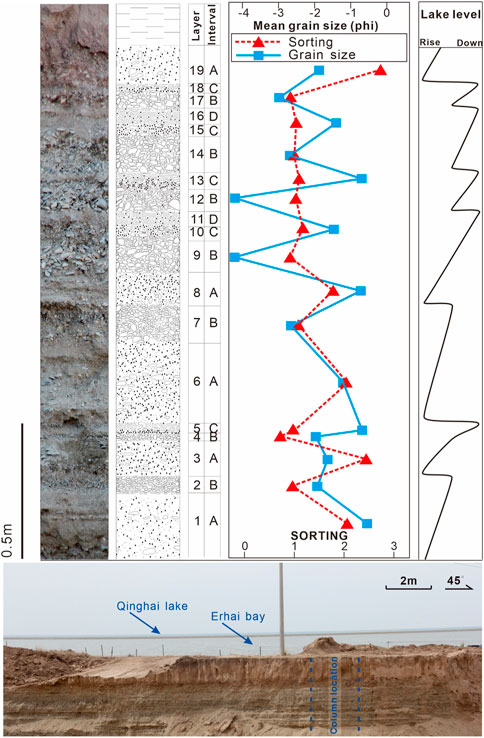
Figure 8. Vertical evolution of beach-bars in the southeastern of the Qinghai Lake.
A interval is dominated by gravel and sand, which are sub-rounded, poorly-sorted, massive bedding, and gravels oriented floating in the coarse sands. The mean grain size is between −2 and −1 phi, and the sorting is more than 2. B interval is dominated by gravel, which are sub-rounded, well-sorted, massive bedding. The mean grain size is between −4 and −1.5 phi, and the sorting is less than 2. C interval is dominated by sand, which are the sub-rounded, well-sorted, normal grading bedding. The mean grain size is between −1 and 0, and the sorting is less than 2. Moving from section A to D, the profile demonstrates a gradational shallowing of water depth, vividly capturing the frequent lake-level changes experienced at this site.
Wind waves serve as the primary energy source for beach-bar formation. Within a lake basin, it is the wave action and longshore currents that primarily influence the formation and distribution of beach bars. The term “control functions of wind waves” refers to the generation of longshore currents by waves. These currents represent the net movement along the shoreline, driven by waves that propagate at an angle to the shore in the wave action zone. Rather than a true parallel shoreline current, the longshore current behaves like an asymmetric wave moving parallel to the shoreline, with sediment particles advancing in a “two steps forward, one step back” motion. Wind predominantly controls waves, with the wind’s direction influencing wave propagation and its strength, along with the fetch distance, determining wave power.
The strength and direction of wind waves directly impact beach-bar development: the former dictates the depth range where beach bars can form, while the latter shapes the beach bars and their associated features.
Qinghai Lake, the largest lake in China, is significantly influenced by the Buha River, a 300 km long river that flows into its western part. This river is a key source of energy, generating currents within the lake. The annual runoff amount is 818 million cubic meters, and far greater than the total runoff amount of all the rivers that feed into Qinghai Lake. The lake’s hydrodynamics are also shaped by the prevailing winds from the west and northwest (Table 1). These winds create friction with the lake’s surface, leading to the formation of waves. Additionally, variations in water temperature and the process of evaporation alter the lake’s water density, which in turn triggers vertical circulation. Together, these elements—river inflow, wind action, and temperature-evaporation dynamics—form the cornerstone of Qinghai Lake’s hydrodynamic characteristics.
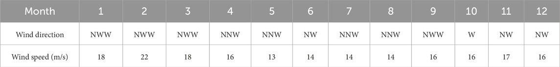
Table 1. Maximum wind speed of each month from 1961 to 1970 in the Qinghai Lake (Lanzhou Branch Chinese Academy of Sciences, 1994).
Data collected from 65 measurement points across the lake reveal a consistent pattern in the water flow direction, primarily influenced by the inflow from the Buha River and the northwest winds. The predominant movement of lake water is from the northwest towards the southeast. However, there are exceptions in certain areas where lake bay reflux occurs, notably in the northern and southern bay areas near the Buha River, as well as in the Heima River district, Erhai bay, and the eastern bay areas (Figure 9).
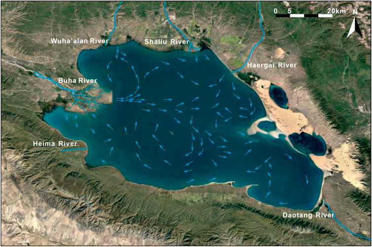
Figure 9. Lake currents orientation of the Qinghai Lake (Ji et al., 2013).
The influence of the northwest wind is a constant feature throughout the year at Qinghai Lake. Records from 1961 to 1970 indicate that monthly maximum wind speeds ranged between 13 m/s and 22 m/s, with average speeds fluctuating from 3.4 m/s to 4.3 m/s (Table 1). This consistent wind pattern plays a crucial role in shaping the lake’s hydrodynamic environment.
The creation of a beach bar is dependent on strong hydrodynamic forces, typically situated above the wave base. The wave base is defined as the maximum depth at which wave action can influence the movement of sediment particles in both sea and lake environments. Beyond this depth, the sediment remains unaffected by wave action. Consequently, the strength of wind waves plays a crucial role in determining the water depth that waves can influence, thereby dictating the depth range conducive to beach bar development.
Meanwhile, the strength of wind waves can determine the sediment structure of beach bars. The higher strength, the better sorting and the coarser particle size, such as the windward zone and the leeward zone.
The growth direction and pattern of beach bars are heavily influenced by the angle of wave approach relative to the lake’s shoreline. This angle, determined by the prevailing wind direction, dictates the morphology of beach bars, as exemplified by the Yilangjian beach bar in Qinghai Lake (Figure 10). Qinghai Lake, for instance, experiences a dominant northwest wind, leading to distinct windward, leeward, and lateral zones within the lake basin. These zones, characterized by their respective positions (northwest, southeast, southwest, and northeast margins), exhibit unique beach bar morphologies and associations due to variations in wind direction and fetch distance.
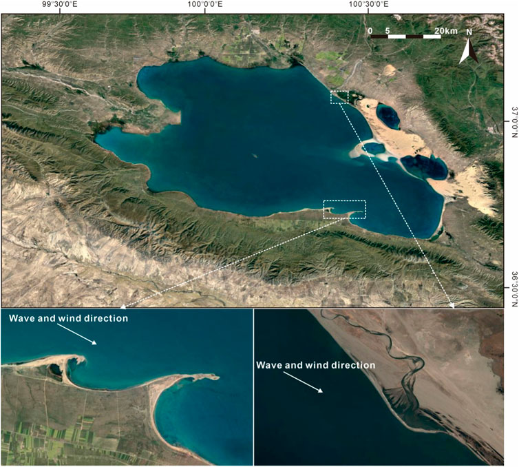
Figure 10. Control of derection of winds and waves on the morphology of beach-bars in the Qinghai Lake.
Windward Zone Characteristics: In the windward zone, where the wind originates, the interaction between the wind and the water body is minimal, resulting in the shortest fetch length, less than 10 km. The shoreline is almost perpendicular to the wind direction (Figure 11). This minimal interaction leads to low wave energy, and consequently, features such as lagoon deposits, cross-shore deposits, and bars are infrequent. Instead, flat beaches without significant bulges are more common (Figure 12A).
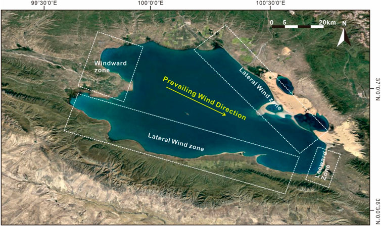
Figure 11. Location of wind areas in the Qinghai Lake.
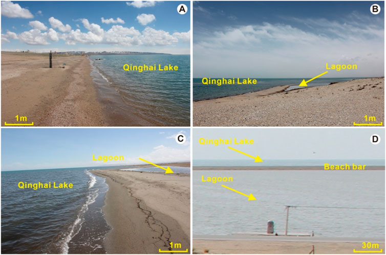
Figure 12. Beach-bar characteristics in the different wind area of the Qinghai Lake ((A) for Windward Zone; (B, C) for Lateral Wind Zone; (D) for Leeward Zone).
Lateral Zone Dynamics: The lateral zone experiences wind passing through the basin, with a moderate fetch length due to a larger area of wind-water interaction, about 10–80 km. The shoreline and wind direction are nearly parallel or at a slight angle (Figure 11). The oblique wave approach in this zone favors the development of coastal flow-type beach bars, semi-enclosed lagoons, and visible cross-shore deposits (Figures 12B, C).
Leeward Zone Features: The leeward zone is directly downwind, characterized by the largest interaction area between the wind and the water, resulting in the longest fetch length, greater than 80 km. Here, the shoreline is almost perpendicular to the wind direction, leading to the strongest wave energy and wave approach almost perpendicular to the shoreline (Figure 11). This environment is conducive to the formation of numerous cross-shore deposits, large fully enclosed lagoon deposits, and a multitude of bars, with fewer beaches being present (Figure 12D).
The concept of a “source-sink” system, which traces sediment from its origin (source) to its final deposition area (sink), is instrumental in understanding how provenance controls beach bar formation. This approach is particularly useful in dissecting the complex interactions that lead to beach bar development in various parts of Qinghai Lake.
Beach bar deposits in Qinghai Lake are predominantly found along its northwest, northeast, southeast, and south margins. To analyze these features effectively, Qinghai Lake can be divided into four distinct “source-sink” depositional systems. These systems are defined by a combination of structural, landform, geographical, and provenance characteristics, as well as by the specific locations of beach bar development, the hydrodynamic environment of the lake basin, and sedimentary traits (Figure 13). The four systems are:
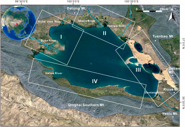
Figure 13. “Source to sink” sedimentary system in the Qinghai Lake.
Datong Mountain - Buha River (Delta) – Wuha’alan River (Delta) - Northwest Margin System: This system is primarily composed of braided river deltas, fan deltas, and beach bars, with sediment originating from Datong Mountain. The lithology of Datong Mountain in the vicinity of the Buha and Wuha’alan rivers includes lower Paleozoic hypometamorphic rocks and granite. Analysis of hydrodynamic and “source-sink” characteristics indicates that the beach bars on the northwest margin primarily derive from the fan delta of the Wuha’alan River (Figures 9, 13).
Datong Mountain - Shaliuhe River (Delta) - Northeast Margin System: Characterized by fan deltas, wave-dominated deltas, and beach bars, this system’s sediments also originate from Datong Mountain, where Sinian metamorphic rocks predominate near the Shaliu River. The source of beach bars on the northeast margin is mainly the Shaliu River fan delta, as suggested by the lake’s hydrodynamic and “source-sink” dynamics (Figures 9, 13).
Riyue Mountain - Daban Mountain - Eolian Deposits–Daotang River - Southeast Margin System: This system, comprising eolian deposits, fan deltas, wave-dominated deltas, and beach bars, is influenced by the consistent northwest and west winds in Qinghai Lake. The Tuanbao and Daban mountains block these winds, causing fine sand to accumulate in front of the mountains. The primary sources of eolian deposits are the Hubei and western Qinghai marginal mountains. The beach bars in the southeast margin are mainly sourced from the Riyue Mountain Delta and eolian deposits, with Riyue Mountain consisting of Pre-Sinian gneiss, granite, and granodiorite (Figures 9, 13).
Qinghai Southern Mountain - Impact Fan (Fan Delta) - South Margin System: Comprising alluvial fans, fan deltas, and beach bars, the sediments here primarily originate from the Qinghai South Mountain, characterized by metamorphic rocks and granite. The beach bars on the southern margin are largely sourced from the adjacent alluvial fan in Qinghai South Mountain (Figures 9, 13).
The availability of sufficient provenance material is essential for the formation of beach bars, as it determines the structural maturity of these features. Beach bars are typically formed through the secondary transport and redistribution of sediments, initially shaped by wave action. This process underscores the importance of provenance type in the development of beach bars. Consequently, beach bars in Qinghai Lake can be categorized into three distinct sedimentary systems based on their provenance: bedrock, alluvial fan (fan delta), and braided river beach-bar systems (Figure 14).
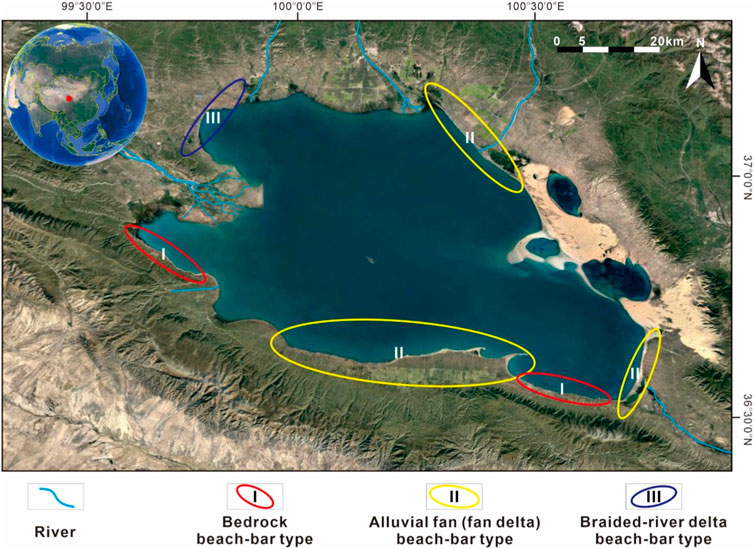
Figure 14. Distribution of different provence beach-bars in the Qinghai Lake.
Bedrock Beach-Bar System: This system includes beach bars located on the southwest margin of Qinghai Lake and those on the east side of Yilangjian. Characterized by their proximity to the sediment source—less than 2 km away—these beach bars are primarily composed of medium-sized gravel, with the largest particles reaching up to 10 cm in diameter. The sediment mix is coarse and poorly sorted, featuring angular gravel pieces (Figures 14, 15A).
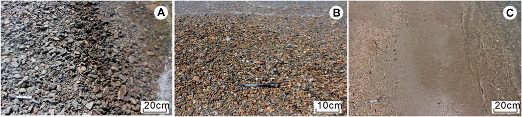
Figure 15. Different provence beach-bars in the Qinghai Lake. (A) for Bedrock Beach-Bar; (B) for Alluvial Fan (Fan Delta) Beach-Bar; (C) for Braided River Beach-Bar.
Alluvial Fan (Fan Delta) Beach-Bar System: Beach bars on the east, southeast, and northeast margins of Qinghai Lake fall into this category. Their proximity to the provenance varies between 5 km and 40 km. The dominant sediments are fine gravel and coarse sand, with the largest particles measuring up to 5 cm. These sediments are moderately well sorted, exhibiting sub-rounded gravel shapes and featuring structures such as swash cross-bedding and plate cross-bedding (Figures 14, 15B).
Braided River Beach-Bar System: This system is exemplified by the beach bars on the northwest margin of Qinghai Lake, where the distance to the provenance exceeds 40 km. Here, coarse sand is the predominant sediment, supplemented by fine gravel with the largest particles up to 1 cm in diameter. The gravel is sub-circular, and the sediments show medium to good sorting, with common occurrences of swash cross-bedding and plate cross-bedding (Figures 14, 15C).
The topographic and geomorphological characteristics of Qinghai Lake are key factors in controlling the development and distribution of beach bars. Understanding these characteristics through the reconstruction of the sedimentary topography of Qinghai Lake’s beach bars is crucial for analyzing their sedimentary features, distribution patterns, and controlling factors.
In this study, we have utilized remote sensing and bathymetric data to reconstruct the contour map of Qinghai Lake’s basin elevation (Figure 16). The surface elevation of Qinghai Lake stands at 3,194 m, descending to its deepest point at 3,166 m. At the lake’s center, Haixin Mountain reaches the highest elevation of 3,260 m. The terrain gently slopes on the lake’s eastern shore, ranging from 3,194 m to 3,270 m, in contrast to the steeper terrain of the southern shore, which varies from 3,194 m to 3,300 m. Notably, Tuanbao Mountain on the eastern shore and Qinghai South Mountain on the southern shore exhibit elevations ranging from 3,269 m to 4,025 m and 3,300 m to 4,500 m, respectively. The western and northern shores present very gentle and gentle terrains, with elevations ranging from 3,194 m to 3,245 m and 3,194 m to 3,294 m, respectively, highlighting the varied topographical features surrounding the lake.
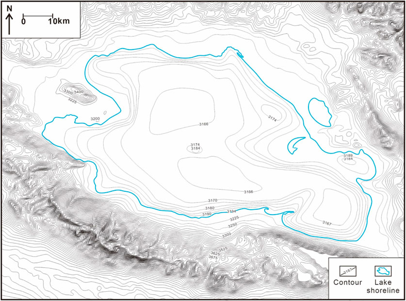
Figure 16. Altitude contour map of the Qinghai Lake.
Further analysis was conducted on the slope of Qinghai Lake’s basin terrain using the elevation difference and horizontal distance, employing the arctangent function for reconstruction (Figure 17). This analysis revealed that the slopes of the eastern and western shores are exceptionally gentle, all below 0.3°. The northern shore’s slope is relatively gentle, not exceeding 0.7°, while the southern shore displays a moderate slope, which can be segmented into five distinct sections. The extremities of the southern shore are notably steep, with slopes reaching up to 3.3° where the lake abuts directly against mountains. The central sections exhibit slopes of 0.7°, 1.3°, and again 0.7°, respectively. Additionally, three areas within the lake basin exhibit anomalous slopes: the frontal slope break zone of the Buha River delta in the west at 0.3°; the frontal fracture zone of the Shaliu River delta in the north at 0.5°; and the uplift area of Haixin Mountain in the center with a slope exceeding 0.5°.
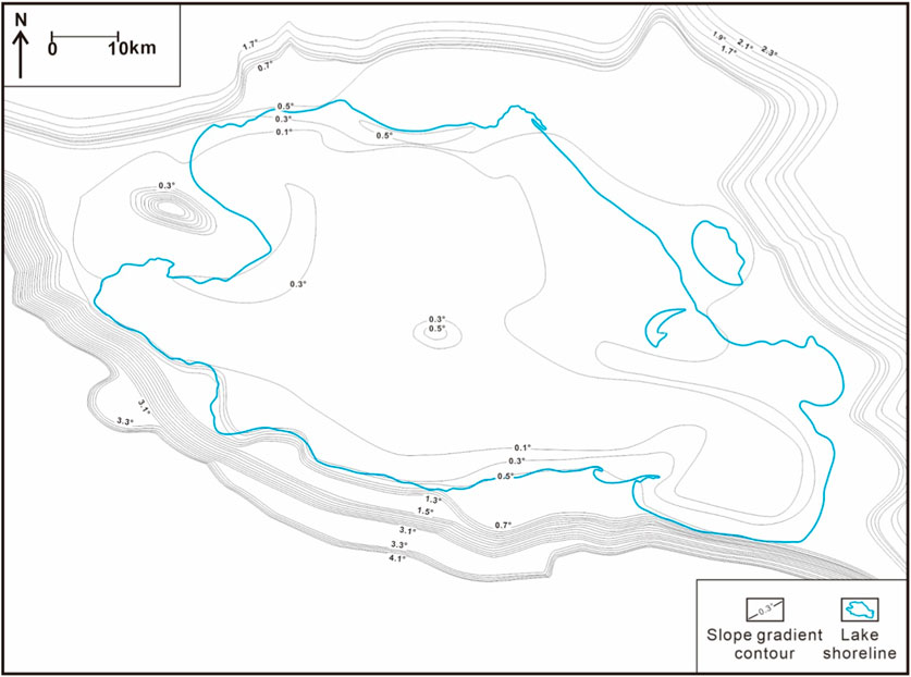
Figure 17. Slope gradient contour map of the Qinghai Lake.
The presence of gentle terrain around Qinghai Lake, a rift lake basin currently experiencing a rift-transform transition, provides favorable conditions for the development of beach bars. The lake basin’s overall geomorphology is relatively gentle due to stable tectonic movements and weaker fault activity. Through the detailed reconstruction of the sedimentary topography and slope of Qinghai Lake’s beach bars (Figures 16, 17), it has been determined that the beach bars predominantly develop on terrain slopes ranging between 0.1° and 0.7°. This finding underscores the significant influence of topography on the formation and distribution of beach bars in the area.
The provenance and topography are closely related. Three beach-bar systems, bedrock beach-bar system, alluvial fan (fan delta) beach-bar system, and braided river beach-bar system has the distinct slopes (Figures 14, 17). The bedrock beach-bar system is more than 1.5°. The alluvial fan (fan delta) beach-bar system is 0.3°–1.5°. The braided river beach-bar system is less than 0.3°.
(1) The formation and spatial distribution of beach bars in Qinghai Lake are governed by an intricate interplay of factors, including lake-level fluctuations, wind wave dynamics, sediment provenance, and terrain gradient. This complex interaction dictates not only the positioning and development of beach bars but also their internal stratification, morphology, and longevity.
(2) Large-scale fluctuations in lake level are the primary drivers behind the positioning of beach bars, essentially determining the initial settings for their formation. In contrast, small-scale fluctuations play a more nuanced role, refining the internal stratification and superimposed patterns within the beach bars, thereby influencing their detailed sedimentary features.
(3) Wind wave dynamics are crucial for defining the depth zones suitable for beach bar development. The direction and intensity of wind waves not only determine the depth at which beach bars can form but also significantly shape their overall morphology and arrangement. This results in distinct sedimentary characteristics across different zones of the lake, including the windward, lateral wind, and leeward zones, each exhibiting unique sedimentary signatures.
(4) Sediment provenance is another key factor that influences the compositional maturity and structural integrity of beach bars. Depending on their source, beach bars in Qinghai Lake can be categorized into three main systems: bedrock, alluvial fan (fan delta), and braided river beach-bar systems. Each system showcases specific compositional and structural attributes that reflect its provenance.
(5) The terrain gradient around Qinghai Lake plays a pivotal role in identifying potential locations for beach bar formation. Areas with a gradient less than 0.7° are particularly favorable, as they provide the optimal conditions for beach bar development. This factor, combined with the aforementioned elements, orchestrates the complex internal structure and distribution patterns of beach bars in the lake.
The original contributions presented in the study are included in the article/supplementary material, further inquiries can be directed to the corresponding author.
BP: Conceptualization, Funding acquisition, Writing–original draft, Writing–review and editing. ZX: Formal Analysis, Funding acquisition, Methodology, Validation, Writing–review and editing. XC: Formal Analysis, Validation, Writing–review and editing. YZ: Formal Analysis, Validation, Writing–review and editing.
The author(s) declare that financial support was received for the research, authorship, and/or publication of this article. The research was conducted with the support of several funding sources, including Technology Innovation Center for Land Engineering and Human Settlements, Shaanxi Land Engineering Construction Group Co., Ltd and Xi’an Jiaotong University (No. 2021WHZ0090), Innovation Capability Support Program of Shaanxi (No. 2024RS-CXTD-55), the project of Shaanxi Province Land Engineering Construction Group (No. DJTD2023-02), the National Natural Science Foundation of China (No. 42002167), the Natural Science Foundation of Chongqing, China (No. cstc2021jcyj-msxmX0733), the youth project of the science and technology research program of the Chongqing Education Commission of China (No. KJQN202101530), the China Postdoctoral Science Foundation (No. 2023MD734109), the Open Fund of Key Laboratory of Tectonics and Petroleum Resources (China University of Geosciences), Ministry of Education (No. TPR-2023-06), and the Open Fund of Key Laboratory of Sedimentary Basins and Petroleum Resources, Ministry of Natural Resources (No. cdcgs2023009).
Authors BP and XC were employed by Shaanxi Land Engineering Construction Group Co., Ltd.
Authors XC were employed by Shaanxi Fruit Industry Development Co., Ltd.
The remaining authors declare that the research was conducted in the absence of any commercial or financial relationships that could be construed as a potential conflict of interest.
All claims expressed in this article are solely those of the authors and do not necessarily represent those of their affiliated organizations, or those of the publisher, the editors and the reviewers. Any product that may be evaluated in this article, or claim that may be made by its manufacturer, is not guaranteed or endorsed by the publisher.
An, Z. S., Wang, P., Shen, J., Zhang, Y. X., Zhang, P. Z., Wang, S. M., et al. (2006). Geophysical exploration research on the lakebed structure and sediment distribution of Qinghai Lake. Science in China ser. D. Earth Sci. 36 (04), 332–341.
Chen, K. Z., Bowler, J. M., and Kelts, K. (1990). Palaeoclimatic evolution within the Qinghai-Xizang (Tibet) plateau in the last 40 000 years. Quat. Sci. 10 (1), 21–31.
Chinese Academy of Sciences (1979). Comprehensive survey report on Qinghai Lake. Beijing: Science Press.
Folk, R. L. (1966). A review of grain-size parameters. Sedimentology 6 (2), 73–93. doi:10.1111/j.1365-3091.1966.tb01572.x
Hongwen, D., Yi, X., Li, X. M., and Zhenglong, J. (2011). Genetic type, distribution patterns and controlling factors of beach and bars in the second member of the Shahejie formation in the Dawangbei Sag, Bohai Bay, China. Geol. J. 46 (4), 380–389. doi:10.1002/gj.1290
Ji, Y. L., Lu, H., and Liu, Y. R. (2013). Sedimentary model of shallow water delta and beach bar in the member 1 of Paleogene funing Formation in Gaoyou sag, Subei basin. J. Palaeogeogr. 15 (05), 729–740.
Jiang, Z., Liu, H., Zhang, S., and Su, X. (2011). Sedimentary characteristics of large-scale lacustrine beach-bars and their Formation in the eocene boxing sag of Bohai Bay basin, east China. Sedimentology 58 (5), 1087–1112. doi:10.1111/j.1365-3091.2010.01196.x
Jiang, Z. X., Wang, J. H., and Zhang, Y. F. (2015). Advances in beach-bar research: a review. J. Palaeogeogr. 17 (04), 427–440.
Lanzhou Branch Chinese Academy of Sciences (1994). Evolution and prediction of the recent environment of Qinghai Lake. Beijing: Science Press.
Li, P. (2015). Influence of wind regimes on the formation of beach bars in Qinghai Lake, NW China. Sediment. Geol. 319, 134–145.
Lister, G. S., Kelts, K., Zao, C. K., Yu, J. Q., and Niessen, F. (1991). Lake Qinghai, China: closed-basin like levels and the oxygen isotope record for ostracoda since the latest Pleistocene. Palaeogeogr. Palaeoclimatol. Palaeoecol. 84 (1), 141–162. doi:10.1016/0031-0182(91)90041-o
Liu, Q. H., Zhu, H. T., Shu, Y., Zhu, X. M., Yang, X. H., and Fu, X. (2015a). Provenance systems and their control on the beach-bar of Paleogene enping formation, enping sag, pearl river mouth basin. ACTA Pet. Sin. 36 (03), 286–299.
Liu, W. G., Li, X. Z., An, Z. S., Xu, L. M., and Zhang, Q. L. (2013). Total organic carbon isotopes: a novel proxy of lake level from Lake Qinghai in the Qinghai-Tibet Plateau, China. Chem. Geol. 347 (6), 153–160. doi:10.1016/j.chemgeo.2013.04.009
Liu, X. J., Lai, Z., Madsen, D., and Zeng, F. (2015b). Last deglacial and Holocene Lake level variations of Qinghai Lake, north-eastern Qinghai–Tibetan plateau. J. Quat. Sci. 30 (3), 245–257. doi:10.1002/jqs.2777
Liu, X. J., Lai, Z. P., Fan, Q. S., Long, H., and Sun, Y. (2010). Timing for high lake levels of Qinghai Lake in the Qinghai-Tibetan plateau since the last interglaciation based on quartz OSL dating. Quat. Geochronol. 5 (2), 218–222. doi:10.1016/j.quageo.2009.03.010
Liu, X. J., Lai, Z. P., Madsen, D., Yu, L., Liu, K., and Zhang, J. (2011). Lake level variations of Qinghai Lake in northeastern Qinghai-Tibetan Plateau since 3.7ka based on OSL dating. Quat. Int. 236 (1-2), 57–64. doi:10.1016/j.quaint.2010.08.009
Liu, X. Q., Wang, S. M., and Shen, J. (2003). The grainsize of the core QH-2000 in Qinghai Lake and its implication for paleoclimate and paleoenvironment. J. Lake Sci. 15 (2), 112–117. doi:10.18307/2003.0203
Madsen, D. B., Ma, H., David, R., Brantingham, P. J., and Forman, S. L. (2008). Age constraints on the late quaternary evolution of Qinghai Lake, Tibetan plateau. Quat. Res. 69 (2), 316–325. doi:10.1016/j.yqres.2007.10.013
Rhode, D., Ma, H., Madsen, D. B., Brantingham, P. J., Forman, S. L., and Olsen, J. W. (2010). Paleoenvironmental and archaeological investigations at Qinghai Lake, western China: geomorphic and chronometric evidence of lake level history. Quat. Int. 218 (1), 29–44. doi:10.1016/j.quaint.2009.03.004
Shang, X. F., Hou, J. G., Dong, Y., Li, Y., Tang, L., Deng, X. L., et al. (2014b). Sedimentary mechanism and distribution pattern of beach-bar sandbodies mainly dominated by contemporaneous faults in Banqiao Sag. J. China Univ. Petroleum Ed. Nat. Sci. 38 (6), 32–39.
Shang, X. F., Hou, J. G., Sun, F. T., Tang, L., Liu, Y. M., Li, Y. Q., et al. (2014a). Architectural characteristics and sedimentary models of beach-bar sandstone reservoirs: a case study of the Paleogene Shahejie Formation in Banqiao oilfield, Huanghua depression. ACTA Pet. Sin. 35 (6), 1160–1171.
Wang, J., et al. (2001). Sedimentary characteristics of beach bars in Qinghai Lake. J. Lake Sci. 13 (4), 297–304.
Wang, S. M., and Shi, Y. F. (1992). Review and discussion on the late quaternary evolution of Qinghai Lake. J. Lake Sci. 4 (3), 1–9. doi:10.18307/1992.0301
Yang, X. Y., Shen, Z. G., Fang, S. X., Hou, F. H., Li, A. Q., Fu, S. T., et al. (2007). Sedimentary characteristics of beach and bar sandbodies in the lower submember of Member 8 of Xiashihezi Fomation of Midd e Pem an in W shenqi Gasfield, Ordos Basin. J. Palaeogeogr. 9 (02), 175–183.
Yu, J. Q., and Kelts, K. (2002). Climatic change in the northeast Qinghai-Tibet Plateau during the late glacial/holocene transition. Quat. Sci. 22 (5), 413–423.
Yuan, B. Y., Chen, K. Z., Bowler, J. M., and Ye, S. J. (1990). The formation and evolution of the Qinghai Lake. Quat. Sci. 03, 233–243.
Zeng, C. (2007). Oxygen isotope records of carbonates from lake Qinghai as environmental archives: Re-explanation. J. Salt Lake Res. 15 (1), 16–19.
Zhang, P. X., Zhang, B. Z., Qian, G. M., Li, H. J., and Xu, L. M. (1994). The study of paleoclimatic parameter of Qinghai Lake since Holocene. Quat. Sci. 03, 225–238.
Zhang, P. X., Zhang, B. Z., and Yang, W. B. (1988). The evolution of the water body environment in Qinghai Lake since the postglacial age. ACTA Sedimeatologica Sin. 6 (2), 5–18.
Zhang, Y., et al. (2010). Ground-penetrating radar investigation of sedimentary structures of beach bars in Qinghai Lake. Geophys. Res. Lett. 37, L12402.
Zhao, C. F., Lu, H. Y., Zhou, Y. L., Yi, S. W., and Mason, J. (2009). Palaeoclimate changes recorded by loess deposit around Qinghai Lake (northeastern Qinghai-Tibetan plateau) since last deglaciation. Geol. J. China Univ. 15 (1), 135–140.
Zhao, D. N., Zhu, X. M., Dong, Y. L., Wu, D., and Zhu, M. (2014). Application of seismic sedimentology to prediction of beach and bar sandbodies in gentle slope of lacustrine basin: a case study of the Lower Cretaceous in Chepaizi area, Junggar Basin, NW China. Petroleum Explor. Dev. 41 (01), 60–67. doi:10.1016/s1876-3804(14)60006-9
Zhou, W., and Li, X. (2005). Geomorphological and sedimentological evidence of lake-level changes in Qinghai Lake in the Holocene. Quat. Sci. 25 (1), 98–107.
Keywords: Qinghai Lake, beach bars, sediment provenance, lake-level fluctuations, wind and wave dynamics, topography
Citation: Peng B, Xu Z, Chen X and Zhao Y (2024) Distribution patterns and controlling factors of beach bars in Qinghai Lake, NW China. Front. Earth Sci. 12:1390039. doi: 10.3389/feart.2024.1390039
Received: 22 February 2024; Accepted: 18 March 2024;
Published: 16 April 2024.
Edited by:
Xixin Wang, Yangtze University, ChinaReviewed by:
Chaojin Lu, University of Miami, United StatesCopyright © 2024 Peng, Xu, Chen and Zhao. This is an open-access article distributed under the terms of the Creative Commons Attribution License (CC BY). The use, distribution or reproduction in other forums is permitted, provided the original author(s) and the copyright owner(s) are credited and that the original publication in this journal is cited, in accordance with accepted academic practice. No use, distribution or reproduction is permitted which does not comply with these terms.
*Correspondence: Zhengjian Xu, eHVtb3UwOEBzaW5hLmNvbQ==
Disclaimer: All claims expressed in this article are solely those of the authors and do not necessarily represent those of their affiliated organizations, or those of the publisher, the editors and the reviewers. Any product that may be evaluated in this article or claim that may be made by its manufacturer is not guaranteed or endorsed by the publisher.
Research integrity at Frontiers
Learn more about the work of our research integrity team to safeguard the quality of each article we publish.