 Hamza El Behja1*†
 Abdelmounim El M’rini1†Driss Nachite1
 Mohammed Bouchkara2Khalid El Khalidi2Bendahhou Zourarah2Md Galal Uddin3,4,5,6
 Mohamed Abioui7,8,9†
- 1Research Laboratory in Applied and Marine Geosciences, Geotechnics and Geohazards (LR3G), Faculty of Sciences, Abdelmalek Essaadi University, Tetouan, Morocco
- 2Marine Geosciences and Soil Sciences Laboratory (URAC 45), Department of Earth Sciences, Faculty of Sciences, Chouaïb Doukkali University, El Jadida, Morocco
- 3School of Engineering, University of Galway, Galway, Ireland
- 4Ryan Institute, University of Galway, Galway, Ireland
- 5MaREI Research Centre, University of Galway, Galway, Ireland
- 6Eco-HydroInformatics Research Group (EHIRG), Civil Engineering, University of Galway, Galway, Ireland
- 7Geosciences, Environment and Geomatics Laboratory (GEG), Department of Earth Sciences, Faculty of Sciences, Ibnou Zohr University, Agadir, Morocco
- 8Marine and Environmental Sciences Centre (MARE)—Sedimentary Geology Group, Department of Earth Sciences, Faculty of Sciences and Technology, University of Coimbra, Coimbra, Portugal
- 9Laboratory for Sustainable Innovation and Applied Research, Universiapolis—International University of Agadir, Agadir, Morocco
Coastal lagoons are valuable ecosystems, providing socioeconomic benefits and supporting human populations and biodiversity. However, these systems face several challenges, making them vulnerable to both natural and human factors. In this study, we apply the Driver-Pressure-State-Impact-Response (DPSIR) Approach to conduct a comprehensive socioeconomic and environmental assessment of the Khenifiss Lagoon to promote sustainable development and support decision-makers. Located on the southern Atlantic coast of Morocco, the lagoon was designated a natural reserve in 1962, a biological reserve in 1983, and a protected wetland under the Ramsar Convention since 1980. This study represents the initial endeavor to conduct a comprehensive global and multidisciplinary environmental assessment of the lagoon by using a wide range of data sources, including relevant publications and reports, satellite images and remote sensing data, field observations, and interviews, all analyzed under the DPSIR framework. Our findings show that both natural and human factors have an impact on the ecosystem. Natural Factors associated with the geomorphological features of the region likely contribute to the silting of the lagoon, possibly intensified by a large shipwreck stuck at its inlet. Meanwhile, human factors encompass population growth (at a rate of 2% per year), tourism, shellfish farming, fishing, shellfish harvesting, and salt extraction. Our results reveal significant changes in the lagoon’s condition in recent years, including a reduction in water body extent, a probable decrease in depth, and an increase in the accumulation of solid waste, plastics, and wastewater in three sectors spanning a total surface area of 464 ha (equivalent to 7% of the lagoon), a substantial expansion of the salt mining area encompassing 368 ha, and a remarkable loss of biodiversity, manifested in declining fish stocks and seabird populations. This study showed that the lagoon is positioned as a potential site for economic growth and serves to alert stakeholders and the local population to the ecosystem’s environmental issues. Based on the findings of this study, we highly recommend regulating human activities within the lagoon, the removal of the wreck at the entrance, proper waste management, community awareness programs, and strict monitoring and enforcement of regulations to protect the environment.
Highlights
• This study employs the DPSIR approach to conduct an exhaustive analysis of the socioeconomic and environmental aspects of Khenifiss Lagoon.
• The research sheds light on the vulnerability of Khenifiss Lagoon to both natural forces and human activities.
• Through meticulous data analysis, this research reveals significant changes in the lagoon’s condition over recent years.
• Guiding sustainable development and conservation at Khenifiss Lagoon.
1 Introduction
Coastal lagoons are shallow water bodies separated from the ocean by a barrier connected, at least intermittently, to the ocean by one or more restricted inlets (Barnes, 1980; Kjerfve, 1986; Gonenc and Wolflin, 2004). Their freshwater inflow is reduced in comparison to their marine water inflow, distinguishing them from estuaries (Chapman, 2012). Coastal lagoons cover 13% of the earth (Barnes, 1980; Newton et al., 2018) and provide a diverse range of ecosystem services and benefits. These include supporting biodiversity, water provisioning, food provisioning, carbon sequestration, providing nursery habitat for various marine species, generating employment opportunities, enabling scientific research, and providing cultural services (Newton et al., 2018; Rodrigues-Filho et al., 2023). These contributions significantly enhance human wellbeing (Mahapatro et al., 2013; Lewison et al., 2016; Rodrigues-Filho et al., 2023). Lagoons, on the other hand, face a variety of challenges and are regarded as vulnerable systems due to natural stressors (e.g., flooding due to excessive precipitation or drought due to insufficient precipitation, sea-level rise, cyclones, super cyclones, hurricanes, major storms, shoreline changes, and longshore littoral drift) and human stressors (e.g., pesticide pollution, sewage pollution, radionuclides, oil spills, sound pollution, coastal pollution, coastal aquaculture, excessive use of motorboats for fishing and tourism activities, and eutrophication) (Mahapatro et al., 2013).
The Khenifiss lagoon (KL) in Morocco, the largest Atlantic lagoon in the country and the only one situated in the Saharan bioclimatic stage (Orbi and Nemmaoui, 1992), remains the least studied (Mejjad et al., 2020). This coastal wetland is characterized by the richness of biodiversity and a high level of biological productivity, meeting the criteria outlined by the Ramsar Convention 1, 2, 3, 4, 5, 6, and 8 (Dakki et al., 2003). With 27 species of mammals, 30 species of macroalgae, and 72 species of vascular plants, as well as 36 Polychaetes, 96 Crustaceans, and 57 Mollusks, this coastal wetland also serves as a habitat for over 10% of the global population of Audouin’s gull (Larus audouinii) (Dakki et al., 2003). It stands as the second major concentration area in Morocco for the Greater Flamingo (Phoenicopterus roseus), hosting over 1,000 individuals, and the fourth concentration area for shorebirds, with nearly 20,000 individuals (Dakki et al., 2003).
The lagoon serves as a critical wintering area for migratory birds along the East Atlantic flyway, predominantly originating from breeding colonies in Algeria, Spain, France, Italy, and potentially Mauritania (Radi et al., 2022; Rihane et al., 2023). Additionally, it provides habitat for vulnerable or threatened species on both national and international scales. These include two plant species (Zostera noltii and Suaeda ifniensis), an amphibian (Bufo brongersmai), and four bird species (Phalacrocorax carbo maroccanus, Marmaronetta angustirostris, Tadorna ferruginea, and L. audouinii) (Dakki et al., 2003). However, the lagoon faces many challenges due to extensive human activities, including habitat destruction, overfishing, disturbance to wildlife habitats, and alterations to water quality, related to the needs of the local population and the requirements of tourist activities (Mirari et al., 2020). In such a situation, establishing a sustainable management strategy to protect the wetland and conserve natural resources through participatory approaches is essential (Roy et al., 2012). Additionally, this strategy depends on a scientific foundation that enables us to understand the spatiotemporal scales of processes and differentiate between natural and anthropogenic sources of stress (Pérez-Ruzafa et al., 2019).
Despite efforts to identify and categorize coastal lagoons’ services and issues, accurately evaluating their value remains a challenging and unresolved issue due to the significant heterogeneity of approaches and methodologies employed in the process (Pérez-Ruzafa et al., 2019). The Driver-Pressure-State-Impact-Response (DPSIR) framework is widely applied in a variety of systems and contexts, including lagoons, estuaries, bays, salt marshes, and rivers, as well as additional ecosystems like coral reefs, mangroves, wetlands, forests, grasslands, deserts, and urban areas (Bidone and Lacerda, 2004; Lin et al., 2007; Elliott and Whitfield, 2011; Zebardast et al., 2015; Lewison et al., 2016; Fiandra, 2020; Kaur et al., 2020; Pagan et al., 2020; Bouchkara et al., 2021). The DPSIR framework comprises driving forces (D) such as population growth, economic development, and climate change leading to environmental effects. Pressures (P) involve human activities causing environmental changes, and State (S) reflects the environmental condition influenced by both natural and human-induced pressures (Kristensen, 2004). Impact (I) pertains to consequences on ecosystem services due to changes in the ecosystem state, and Response (R) involves decision-making to minimize changes, control driving forces or pressures, and restore the environmental state (Kristensen, 2004).
The utilization of the DPSIR framework in diverse global coastal wetlands, such as the Venice Lagoon in Italy (Fiandra, 2020), coastal wetlands in Xiamen, China (Lin et al., 2007), Brazil’s Guanabara Bay (Bidone and Lacerda, 2004), and the lagoon of Oualidia in Morocco (Bouchkara et al., 2021), has yielded valuable insights into environmental issues in these coastal wetlands and has proven instrumental in facilitating the assessment of coastal development and sustainability across these regions. This framework is also widely utilized for managing vulnerable seagrass ecosystems and salt marshes, offering a structured approach to assess and address environmental challenges in these critical coastal habitats (Mishra and Apte, 2021; Mishra and Farooq, 2022). The application of the DPSIR framework to the Venice lagoon in the northeastern part of Italy (Fiandra, 2020) has yielded a comprehensive understanding of its main issues and the corresponding responses over time. Additionally, this framework is recommended as a primary tool for managing complex marine territories and, more importantly, for adoption in governmental assessments (Fiandra, 2020). The application of the DPSIR framework to the coastal wetlands in Xiamen, China (Lin et al., 2007) allows monitoring of the structural and functional changes within this Chinese coastal wetland, including physical, chemical, and biological aspects, from 1950 through 2005. The findings show a significant rise in anthropogenic factors, including human population growth and economic development, contributing to coastal wetland degradation in this area since 1950, which is correlated with a decline in coastal wetland function during that time. The DPSIR implementation in Brazil’s Guanabara Bay (Bidone and Lacerda, 2004) enables the assessment of coastal development and sustainability, evaluating the costs and gains related to governmental policies regarding the use of natural resources. The results highlight the significance of successful public policies in resource management and sustainable resource use. In Morocco, the DPSIR framework has been specifically applied to the lagoon of Oualidia (Bouchkara et al., 2021), revealing the unsustainable utilization of this ecological space and the resulting degradation and environmental challenges, including organic and chemical pollution, the expansion of urban areas, environmental disturbances, and the loss of wetlands. By utilizing the DPSIR framework, it was possible to establish connections between socio-economic activities, their impacts on lagoon sustainability, and human interventions aimed at mitigating these effects (Bouchkara et al., 2021). The DPSIR framework enabled the proposal of measures to enhance ecological productivity, ensure resource sustainability, and integrate ecosystem management (Bouchkara et al., 2021).
Transitioning to the specific focus on KL, this paper aims to provide an integrated environmental and socioeconomic assessment of this coastal ecosystem, shedding light on the intricate interactions between socioeconomic and environmental factors within the lagoon. Additionally, we seek to categorize its ecosystem services and issues using a diverse set of data sources, such as scientific publications, technical reports, field observations, interviews, satellite images, and remote sensing data, all analyzed under the DPSIR framework. This integrated assessment is intended to aid decision-makers in comprehending the intricacies of environmental challenges and making informed decisions through a structured and all-encompassing assessment of the issues before implementing potential management strategies. Finally, this paper aims to highlight the potential benefits of the DPSIR approach for analyzing and managing such a coastal wetland and ensuring its sustainability.
2 Study area
The KL, depicted in Figure 1, lies 200 km north of Laayoune city in the Tarfaya province, situated in a rural area along Morocco’s southwest coast (28°02′54″N, 12°13′66″W). This region is renowned for its significant deposits of ferrotitanium minerals along the Laâouina–Cape Juby Atlantic coastline (Abioui et al., 2023). The KL is the biggest lagoon on the Atlantic coast of Morocco (Beaubrun, 1976). The lagoon has been classified as a natural reserve since 1962, a biological reserve since 1983 (Cuzin, 2003), and a protected wetland by the Ramsar Convention on Wetlands of International Importance since 1980 (Dakki et al., 2003). It has been recognized as a national ecological park with a 606,000-hectare surface area since 2006 (National Agency of Water and Forests, 2022). The lagoon covers an area of 65 km2 and runs deep inland for more than 20 km (Lakhdar Idrissi et al., 2004). It connects to the Atlantic Ocean via a wide passage, known as Foum Agouitir, carved through the coastal dune cord, with depths ranging from 5 to 6 m (Beaubrun, 1976; Lakhdar Idrissi et al., 2004). Upstream, it extends to the salt flat referred to as the Sebkha of Tarza (Beaubrun, 1976). The main channel is bounded to the east and south by a cliff (25–35 m high) and to the west by living dunes (Beaubrun, 1976; Mirari et al., 2020).
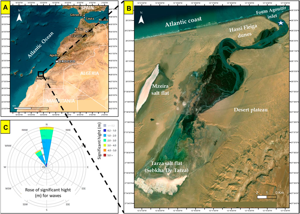
Figure 1. (A) Geographic location of the KL; (B) top view of the KL and its surrounding environment (the white star indicates the location of a huge shipwreck stuck at the bottom of the inlet as shown in Figure 4D); (C) Wave rose of significant wave height and mean wave direction at the entrance of the lagoon (Foum Agouitir) based on data from 2000 to 2024 for SIMAR Point 1032014 (https://www.puertos.es/).
Saline waters enter the mouth of Foum Agouitir and flow through a broad channel that narrows gradually towards the south. The main channel eventually splits into several small and narrow channels. Figure 1C depicts the predominant wave direction that influences the study area, particularly the mouth. The waves consistently approach from the north, with significant wave heights ranging from 0.2 m to 5 m (Figure 1C). Lakhdar Idrissi et al. (2000) and Lakhdar Idrissi et al. (2004) categorized the lagoon into three zones based on its hydrological characteristics. The first zone, located downstream, was predominantly influenced by the ocean and characterized by coarse sediments. Water depths ranged from 2.5 to 6 m, and the maximum current speed reached approximately 110 cm/s. The second zone, situated in the middle of the lagoon, exhibited an intermediate level of oceanic influence and shared similar sediment characteristics with the first zone. Lastly, the third zone, positioned upstream, experienced minimal oceanic influence and shallower water depths ranging from 2.64 to 5.3 m. Salinity levels within the lagoon vary spatially, with gradual increases observed towards the upstream zone. While the downstream and central zones maintain salinity levels similar to those of the ocean, around 36 psu, the upstream zone experiences higher salinity, reaching 45 psu (Lakhdar Idrissi et al., 2004; Lefrere et al., 2015). Similar spatial patterns were noted for water temperature, fluctuating between 17°C and 25°C (Lakhdar Idrissi et al., 2004). The semi-diurnal component (M2) of the current, with a period of 12 h and 25 min, significantly dominates the tidal cycle in the KL (Lakhdar Idrissi et al., 2004). The water residence time in the lagoon has been estimated to be approximately 4.4 tidal cycles during neap tides and 1.5 tidal cycles during spring tides (Lakhdar Idrissi et al., 2004). The lagoon supports the livelihoods of people living in nearby areas, where the majority of activities are related to fishing, tourism, salt extraction, and occasional agriculture in the Graras, which transform into relatively productive cereal fields during rainy years (Department of Water and Forestry, 2008).
3 Materials and methods
3.1 Data collection
3.1.1 Bibliographic analysis
Various search engines, including Scopus, Google Scholar, ISI Web of Knowledge, ScienceDirect, JSTOR, and ResearchGate, were utilized to conduct searches using keywords such as “Khenifiss lagoon,” “lagoons,” “coastal lagoon,” “DPSIR,” “ecosystem services,” “ecosystem assessment,” “environmental assessment,” “coastal management,” “coastal lagoon management,” and “ecosystem management.” This search strategy yielded a total of 88 relevant publications for the study. These publications included 60 peer-reviewed papers, Seven reports and technical reports from government agencies (i.e., the Department of Water and Forestry, the Ministry of Equipment and Transport, and the High Commissioner of Planning) and other organizations (i.e., RAMSAR, UNESCO, the European Environment Agency), seven books and book chapters, five conference proceedings, three PhD thesis, one Masters' thesis, three official websites (Haut Commissariat au Plan, the National Agency of Water and Forests, the Khenifiss Association), and 1 EEA internal working paper.
The study’s collected publications were analyzed and sorted into several categories. Out of the total number of publications, 24 (27.27%) were specifically centered on the KL and its surrounding environment, and 21 publications (23.86%) were focused on general coastal or terrestrial issues and ecosystem assessment. Additionally, 10 publications (11.36%) discussed coastal management, natural resource management, and sustainability, while 12 publications (13.63%) focused on the application of the DPSIR framework. Biodiversity and ecosystem services were covered in 13 publications (14.77%), and eight publications (9.09%) explored the functioning of marine ecosystems, coastal lagoon processes, and coastal processes.
3.1.2 Field observation and interviews
We conducted field observations and interviews with local authorities, fishermen, salt miners, and residents in February 2022 to evaluate the present condition of the lagoon and identify any modifications that may have transpired in recent years. Our approach involved visually inspecting the study area to detect and identify polluted zones, especially those caused by solid waste. We identified contaminated areas and determined the types of solid waste to understand the origin of the pollution.
Conducting interviews was challenging due to the population’s conservative nature, particularly among women, and their hesitancy to interact with outsiders. Moreover, the population was relatively small and widely dispersed across vast areas around the lagoon, resulting in a limited number of participants being available for questioning. A sample of 50 individuals, representative of the local population (Table 1), was surveyed, and the interviews were limited to residents who had lived in the area for more than 5 years. They were asked four questions. Firstly, they were asked whether they had observed any significant changes in the lagoon during their stay. Secondly, they were asked whether they were satisfied with the current state of the lagoon area. Furthermore, they were asked whether they felt the local government was doing enough to protect and maintain the lagoon. Lastly, they were asked to provide suggestions for improvements they would like to see made to the lagoon area. The survey aimed to capture the needs and desires of the residents living in the region.
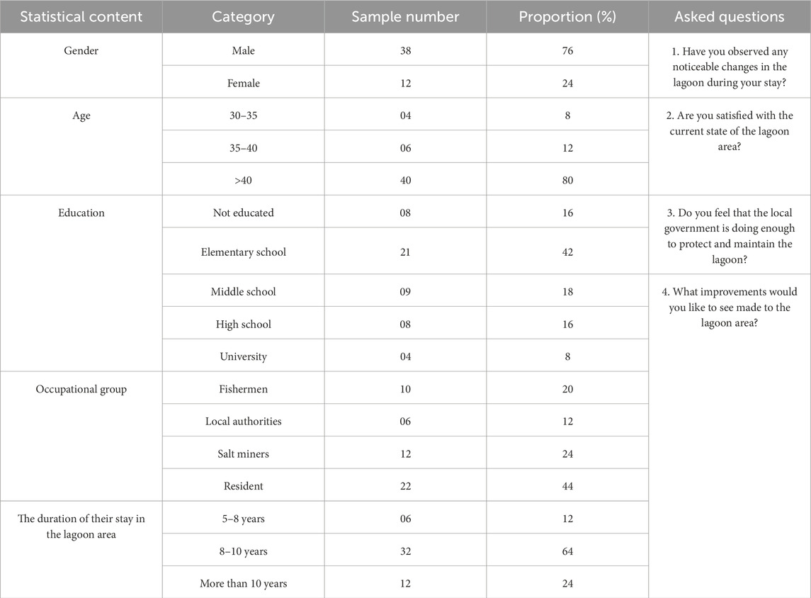
Table 1. Summary of sample population characteristics and interview questions.
3.1.3 Integration of remote sensing and geographic information systems (GIS)
The current study utilized Geographic Information Systems (GIS) to map the areas where contamination is found, providing a spatial representation of the polluted zones. Additionally, we utilized satellite images and remote sensing to investigate the long-term changes in the land use of the lagoon. We assessed the evolution of salt mining activities in the Sabkha of Tarza from 2000 to 2019 using three Landsat optical images obtained from the United States Geological Survey (USGS). The three images were collected in 2000, 2009, and 2019, with an average time interval of approximately 10 years. We created false-color composites by coding bands in blue, green, and red, respectively, as outlined in Table 2, using GIS software. These band combinations were selected based on their ability to highlight the unique spectral signatures of salt deposits and to provide insights into the temporal changes in mining activities.
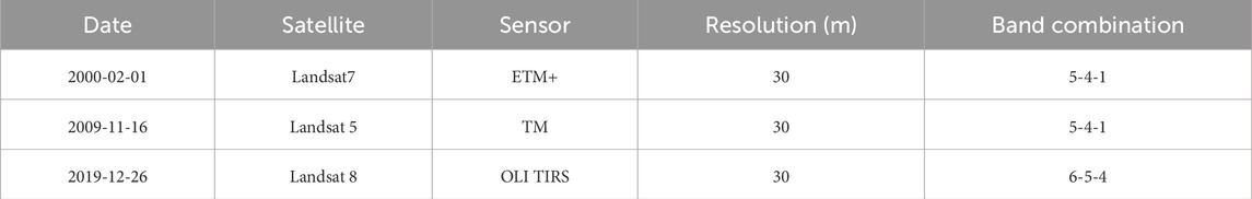
Table 2. Detailed information and band combinations of selected remote sensing imagery.
3.1.4 Assessment of sediment quality, water quality, and biodiversity
To assess the sediment quality in the lagoon, we utilized sediment quality guidelines (SQGs) and analyzed data on metal concentrations extracted from the sediment, building upon previous research conducted by Tnoumi et al. (2021) and Idardare et al. (2008). SQGs are defined as effects-range guidelines based on empirical analyses of chemistry and biological data from a variety of field and laboratory studies (Long et al., 1995; Long et al., 1998; Macdonald et al., 1996). The NOAA’s effects-range approach, which utilizes the effects range-low (ERL) and effects range-median (ERM), is the most commonly used SQGs for marine environments (Long et al., 1995; Long et al., 1998; Long et al., 2000; Long and Sloane, 2004). Another widely used effects-range approach is based on the threshold effects level (TEL) and probable effects level (PEL) (Macdonald et al., 1996). The ERL and TEL are highly predictive of no toxicity if they are not exceeded, while the ERM and PEL are highly predictive of toxicity if they are exceeded (Long et al., 1998).
The examination of previous studies conducted in the lagoon has provided insights into the dynamic evolution of water quality and biodiversity over time. Moreover, it has shed light on the intricate relationship between human activities and their influence on the delicate balance of the ecosystem within the lagoon’s habitat.
3.2 Data analysis
Relevant information from the publications, field observations and interviews, satellite images, and remote sensing was compiled, analyzed, and tabulated into a DPSIR framework (Figure 2) to study the issues and problems associated with the lagoon’s use and management (Lewison et al., 2016; Elliott et al., 2017; Fiandra, 2020). The DPSIR framework is an integrated approach for reporting the state of the environment adopted by the European Environment Agency (EEA) since 1995 (Thomas, 1995; Kristensen, 2004). It is used to describe the relationships between the origins and consequences of environmental problems, as well as to define the causal links existing along the chain, beginning with driving forces, the resulting environmental pressures, the state of the environment, and impacts resulting from changes in environmental quality, eventually leading to the societal response to these changes in the environment (Kristensen, 2004).

Figure 2. The Driver-Pressure-State-Impact-Response (DPSIR) framework, according to Kristensen (2004).
The DPSIR framework components are driving forces (D), which relate to anthropogenic factors such as population growth and demographic change, economic and industrial development, and climate change, which can lead to environmental effects (Gabrielsen and Bosch, 2003; Lewison et al., 2016). According to the Millennium Ecosystem Assessment (2005), drivers can include both anthropogenic and natural factors that directly or indirectly cause a change in an ecosystem. Pressures (P) are defined as human activities that usually cause unwanted environmental changes through emissions (the release of substances) and the use of resources, leading to observable and measurable effects in the ecosystem (Gabrielsen and Bosch, 2003; Maxim et al., 2009). State (S) refers to the environmental condition of the lagoon, which is influenced by both natural and human-caused pressures (Takyi et al., 2022). State indicators can vary in type depending on the system chosen for description (i.e., changes in biodiversity, physicochemical properties, quantity and quality of resources, etc.) (Maxim et al., 2009; Takyi et al., 2022). Impact (I) relates to the consequences of changes in the state of the ecosystem services provided by the concerned ecosystem (Gabrielsen and Bosch, 2003; Moll et al., 2005; Takyi et al., 2022). Response (R) relates to decision-making (Takyi et al., 2022), to minimize changes, control driving forces or pressures, and restore the state of the environment (Maxim et al., 2009; Takyi et al., 2022).
4 Results and discussion
4.1 Driving forces
4.1.1 Climate, wind action, and geomorphological setting
The climate is characterized by moderate temperatures (20°C on average) and extremely rare precipitation (Adnani et al., 2018). The study area is characterized by a unidirectional wind, the almost absence of vegetation, and the presence of a very flat, hard substrate in the form of a limestone-sandstone plateau (Elbelrhiti et al., 2005). Winds regularly blow over this area, with an RDP/DP index of 0.9 (Elbelrhiti et al., 2005). The prevailing wind blows from NNE to SSW and is classified as a breeze ranging from gentle to frequently strong (Elbelrhiti et al., 2005; Adnani et al., 2018). This direction corresponds precisely to the propagation of the dunes (Elbelrhiti et al., 2005). Coastal environments in the region allow prevailing winds to transport sand inland, thus promoting the formation of transverse dunes and Barchan dunes around the lagoon (Oulehri, 1992; Elbelrhiti et al., 2005; Adnani et al., 2018). The flatness of the relief in the study area promotes the movement of massive masses of sand (Sauermann et al., 2000; Elbelrhiti et al., 2008) and generates a sand river, oriented NNE-SSW, which is responsible not only for the main silting up of the KL but also for the road network and other economic infrastructure in the area (Saltani et al., 2015).
4.1.2 Population growth
Population growth constitutes the primary driving force and leads to changes in individual needs and activities (Lewison et al., 2016). The population of the Khenifiss National Park (Table 3) is growing at a yearly population growth rate of 2 percent and is concentrated in the village of Akhfennir and around the Tarza salt flats (Sebkha of Tarza) (Department of Water and Forestry, 2008; Haut Commissariat au Plan, 2014).
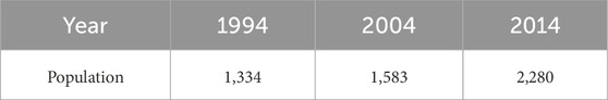
Table 3. Population (number of persons) of the territorial commune of Akhfennir from 1994 to 2014 (Department of Water and Forestry, 2008; Haut Commissariat au Plan, 2014).
As the population grew, so did the demand for resources and the volume of wastewater discharged, resulting in higher levels of contaminants (Pérez-Ruzafa et al., 2019). Also, the anthropogenic development of coastal environments has accelerated environmental pressure on these systems (Niemi et al., 2004; Birch and McCready, 2009). These pressures contribute to environmental changes such as fish abundance and coastal eutrophication (Tagliapietra et al., 2011; Lewison et al., 2016).
4.2 Pressures on the KL
Figure 3 depicts the main human activities in KL. This includes tourism activities, aquaculture, fishing and shellfish harvest, and salt extraction that provide employment opportunities and contribute to the local economy (Department of Water and Forestry, 2008).
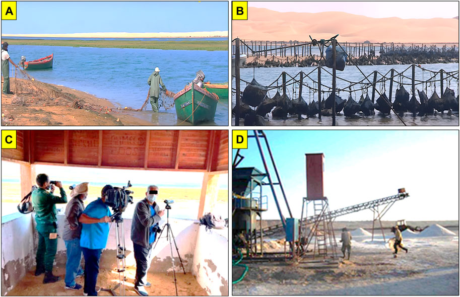
Figure 3. Photographs show the main human activities in KL. (A) Fishing; (B) shellfish farming and aquaculture; (C) tourism and bird watching; (D) salt mining.
4.2.1 Tourism activities
The Khenifiss National Park is a strongly contrasted, diversified, and singular biogeographical richness destination. The park presents exceptional landscapes with a unique ecological quality (Mirari et al., 2020). These include the coastal area, the lagoon zone, and the expansive desert region, featuring regs, hamadas, krebs, and extensive dunes (Mirari et al., 2020). The lagoon forms a vast wetland, which runs deep inland for more than 20 km, is enclosed between sharp dunes and sandstone cliffs, and enlarges to a huge salt flat (Sebkha of Tarza) (Mirari et al., 2020). Official statistics on tourist activities and numbers in the lagoon are unavailable. However, KL offers many activities, including geotourism, ecotourism, bird watching, and nature observation. The increasing tourist development activities around lagoons may lead to environmental disturbances and threaten the safety of biodiversity and the ecological integrity of the ecosystem (Pérez-Ruzafa and Marcos, 2005; Pérez-Ruzafa et al., 2011), necessitating careful monitoring in the Khenifiss Lagoon. Transport and shipping activities may also result in underwater noise pollution and hydrocarbon emissions from motorized boats (Eyring et al., 2005; McCarthy, 2007). Field observations showed an increasing accumulation of solid and plastic waste discarded by tourists and frequent disturbances to bird populations.
4.2.2 Aquaculture, fishing, shellfish farming, and shellfish harvesting
The socio-economic system in the lagoon is based on fishing and shellfish harvests. The local wealth has enabled the local population to develop a fishery, albeit artisanal, but one that generates income and jobs. According to the local authorities, there are only 12 traditional fishing boats, which are also used to transport tourists within the lagoon. However, all of these boats are motorized and operate continuously, which raises concerns about the potential for underwater noise pollution and its adverse effects on the local marine environment while also contributing to water pollution. Moroccan aquaculture began in the 1950s with the establishment of shellfish farming in Oualidia lagoon, which produced 60 tons of Oysters in 2011 (Maanan et al., 2014). In the KL, the local specificities of the ecosystem have attracted many private investors to become involved in aquaculture (Idardare et al., 2008). The KL’s living resources are under pressure due to fishing (Diplodus sargus sargus, Mugil capurrii, Mustelus mustelus, Anarhichas lupus), harvesting (polychaetes, mollusks, and shellfish), and aquaculture activities. Fishing activities, in particular, lead to the depletion of targeted fish, shellfish, and bait populations, with illegal fishing practices and the use of unregulated equipment further exacerbating the problem (El Mahrad et al., 2020). The lack of effective regulations and surveillance mechanisms only compounds these pressures and puts the long-term sustainability of the ecosystem at risk. It is, therefore, crucial to implement appropriate measures to ensure the responsible and sustainable use of KL’s living resources.
Based on the interviews conducted, 100% of the respondents agreed that there has been a significant decline in the fish population in the lagoon in recent years. Fishermen attributed this decline to the probable reduction in the depth of the lagoon’s main channel and emphasized the need for further investigation and action to address this issue.
4.2.3 Salt mining activities
The salt flat (Sebkha of Tarza), covering an area of over 830 ha on the south side of the lagoon, plays an important economic role. In the middle of this huge space, 418 ha of salt deposits were exploited by seven small companies and one cooperative (Department of Water and Forestry, 2008). This salt flat is used as huge man-made salt pans, which produce, among other salt pans in the area, more than 20,000 tons of salt per year (Department of Water and Forestry, 2008). Salt marshes provide vital support for biodiversity and ecosystem services (Mishra and Farooq, 2022). However, uncontrolled exploitation of salt marshes, coupled with a lack of monitoring, leads to the loss of wetlands containing the optimal conditions for biological life and biodiversity, and the waste products abandoned there can distort the environment (Kennish, 2001).
4.3 State changes and impacts on the environment of the KL
4.3.1 Spatial extent and depth of the lagoon
In recent years, KL has experienced a probable decrease in depth (Amimi et al., 2021). Additionally, small islands have emerged within the lagoon channels, and the Portuguese tower sank into the sands in 2010 (Figures 4B, C), which was visible before that date (Figure 4A). This phenomenon of silting and narrowing of the lagoon was proven by comparing archived aerial photographs with recent satellite images, which revealed the growth of small newborn islands and the filling of slikkes by sediment and dunes inside the lagoon’s main and secondary channels, which leads to shoreline changes (Amimi et al., 2021; El Behja et al., 2024). Furthermore, the lagoon experiences a notable decrease in its total water body extent, reflecting the increasing prevalence of sedimentation over erosion and highlighting its vulnerability to progressive closure (El Behja et al., 2024).
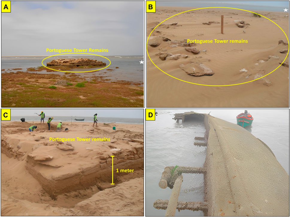
Figure 4. (A) A photograph (taken in 2004) of the remains of the Portuguese tower. The black circle surrounds the tower. The white star indicates the location of the shipwreck in Figure 4D; (B) a photograph (taken in 2011) of the remains of the Portuguese tower, showing the tower sinking into the sand and vegetation disappearing. The black circle surrounds the tower, and the white star indicates the location of the shipwreck in Figure 4D; (C) a photograph of the excavation work to uncover the Portuguese tower, as well as the rate of silting up; (D) a photograph of the shipwreck near the inlet of the KL during the low tide.
According to the data from the technical report of the Ministry of Equipment and Transport (2010), the probable decline in depth is not only due to the general silting that affects the lagoon but also to the presence of a huge shipwreck at the bottom of the inlet since 1978 (Figure 4D), which caused significant alterations to the inlet’s structure and dynamics (Ministry of Equipment and Transport, 2010).
The survey responses to the first question revealed that a significant proportion of the participants, specifically 90%, observed a decline in the lagoon’s depth during their stay. Furthermore, 80% of the respondents identified this probable reduction in depth as a critical issue, linking it to the advance of dunes and silting phenomena. These findings suggest that the lagoon area is undergoing notable changes that require attention and intervention to protect the lagoon ecosystem.
4.3.2 Solid and plastic waste pollution
The study conducted field observations and found a growing accumulation of solid waste, plastics, and wastewater in various locations. Figure 5 illustrates the extent of the problem in three sectors spanning a total surface area of 464 ha (equivalent to 7% of the lagoon) identified as being particularly affected. Sector 1 is situated close to a small harbor primarily utilized by traditional fishing boats. The area is primarily inhabited by a local population, consisting mainly of fishermen and their families. Furthermore, Sector 1 serves as a place of accommodation for visitors and tourists. Sector 2 is located in the middle of the lagoon, situated at the Rass Tarf cliff. It is primarily utilized as a tourist campsite. Lastly, Sector 3 is situated around the salt mining area and is close to the national road N1.
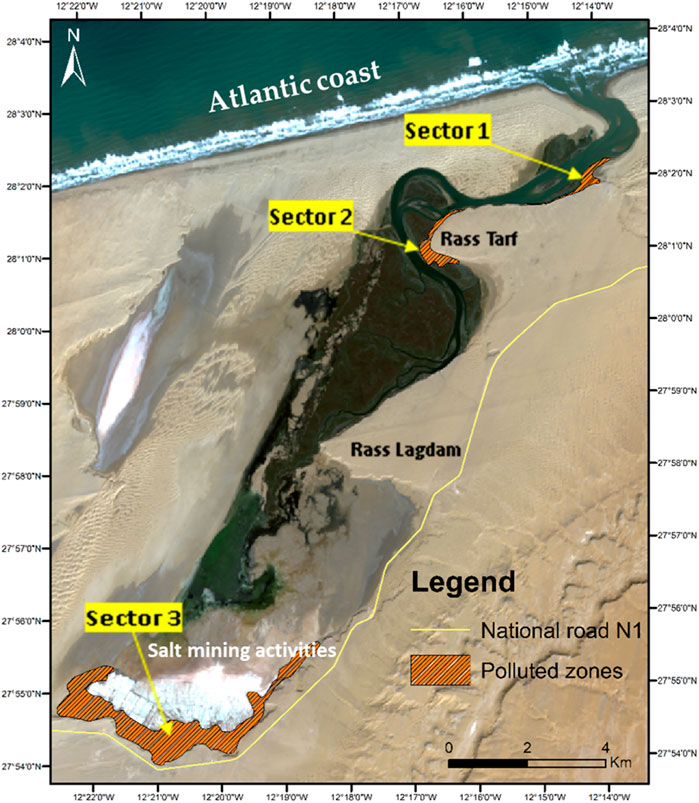
Figure 5. Extent of polluted zones by the solid waste in the KL, as identified through field observations (February 2022).
Table 4 lists each sector and the types of solid waste commonly associated with it. Additionally, it identifies potential sources of pollution. This information can be used to develop strategies to reduce pollution and establish sustainable waste management practices. Complementing this, Figure 6 provides insight into some aspects of pollution observed in sectors 1 and 2. Across the three sectors, pollution sources vary but collectively contribute to environmental degradation and adversely affect ecosystems.
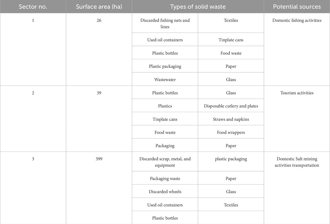
Table 4. Sectors with pollution in the KL associated with solid waste types and potential pollution sources.
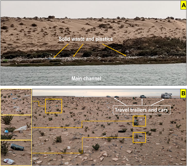
Figure 6. Photographs showing the accumulation of solid waste and plastics in the KL. (A) in sector 2 and (B) in sector 1 (captured in February 2022).
Based on the responses received, all respondents (100%) reported that pollution has increased in recent years due to the lack of waste treatment facilities and the absence of sewage treatment in the area. The interviews conducted revealed that 84% of respondents perceived that the accumulation of solid and plastic waste in sectors 1 and 2 is worsened by residents’ and tourists’ improper disposal practices. Similarly, 50% of respondents reported that salt mining activities contribute to the problem in sector 3. In contrast, a smaller proportion of respondents acknowledged that transportation plays a role in exacerbating the accumulation of solid and plastic waste in sector 3.
4.3.3 Land use
The results of the temporal analysis of salt mining area expansion in Sebkha of Tarza, as depicted in Figure 7, indicate a significant increase in the size of the mining area over the period 2000–2019. The mining area expanded from 114 ha in 2000 to 341 ha in 2009 and 368 ha in 2019, as shown in Table 5. The observed expansion in the salt mining area in Sebkha of Tarza may be attributed to various factors, including increasing demand for salt, advancements in mining technology, and the proximity of the national road. Nevertheless, the potential negative impacts of this expansion on the environment and local communities should be carefully considered and managed to ensure sustainable use of the area.
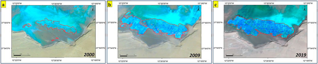
Figure 7. Temporal analysis of spatial expansion in the salt mining area of the Sebkha of Tarza using Landsat satellite imagery from (A) 2000, (B) 2009, and (C) 2019. The red line indicates the boundary of the mining area, and the changes in the area over time are visible.
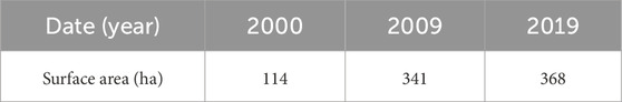
Table 5. Spatial expansion in the salt mining area at the salt flat Sebkha of Tarza (2000–2019).
The findings highlight the importance of continuous monitoring and management of salt mining activities in the Sebkha of Tarza to mitigate the potential negative impact on the ecosystem and ensure sustainable use of the area. Additionally, the use of satellite imagery proves to be a useful tool for monitoring and analyzing changes in mining activities over time, enabling informed decision-making and management.
4.3.4 Water quality
The KL’s water quality is poorly understood. However, a few studies have been conducted to assess it by measuring physico-chemical and microbiological indicators such as temperature, salinity, phosphates, nitrates, dissolved oxygen, and chlorophyll (Fekhaoui et al., 1988; Lakhdar Idrissi et al., 2004; Mimouni et al., 2005). These various indicators change with the tide and exhibit daily and seasonal variations. The authors of these studies have found that the physico-chemical and microbiological parameters of the water meet or exceed the standards for safe and healthy water. They have presented evidence that the water in KL is of good quality.
4.3.5 Sediment quality
Sediment contamination poses a significant threat to the health of benthic organisms, as well as harming the development of vegetation, bacteria, and other forms of aquatic life (MacDonald et al., 1996). Sedimentary metal concentrations can be used as an appropriate indicator of contamination related to anthropogenic activities that lead to biological stress in coastal water bodies (Birch, 2011). Besides, the biogeochemical processes of lagoons can change the characteristics of contaminants, making them more toxic to different aquatic organisms (Kjerfve and Magill, 1989; Gonenc and Wolflin, 2004). To evaluate sediment quality, we assessed the metal concentrations of eight metals in the surface sediments (2–5 cm), including Cr, Ni, Cu, Zn, As, Cd, Hg, and Pb, as depicted in Table 6.
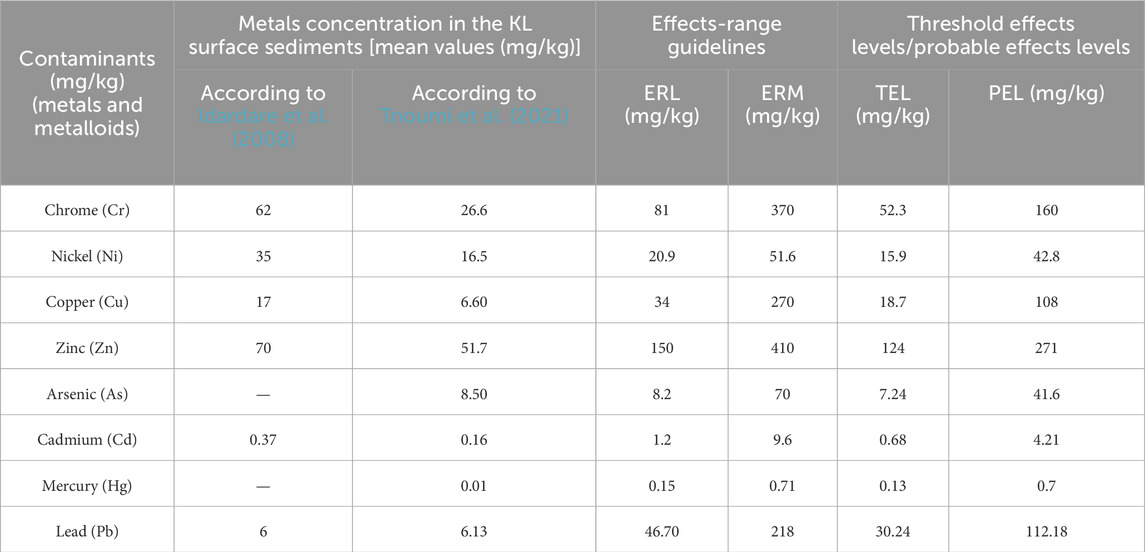
Table 6. Comparison of metal concentration measurements in the KL sediments (Idardare et al., 2008; Tnoumi et al., 2021) with Effects-Range Guidelines (ERL/ERM) (Long et al., 1995) and Threshold Effects Levels/Probable Effects Levels (TEL/PEL) (Macdonald et al., 1996).
The metal concentrations determined by Idardare et al. (2008) are lower than the ER-L (Effects Range-Low) and TEL (Threshold Effect Level) presented in Table 6, except for Nickel (Ni), which is in the range between ER-L and ER-M (Effects Range-Median), and Chrome (Cr), which is in the range between TEL and PEL (Probable Effect Level). The high Ni concentrations found naturally in the sediments of the KL are probably derived from its bedrock, which is characterized by predominant schist rich in Ni (Idardare et al., 2008). The metal concentrations determined by Tnoumi et al. (2021) are also lower than the ER-L and TEL presented in Table 6, except for nickel (Ni), which is in the range between TEL and PEL, and arsenic (As), which is in the range between ER-L and ER-M. The comparison of metal concentrations in the KL sediment with SQGs presents a range between no toxicity (Cu, Zn, Cd, Hg, and Pb) and probable toxicity (Cr, Ni, and As), while no metal concentration exceeds the toxicity limits. The minor enrichments of Cr and As may be related to the human activities around the lagoon (fishing boats, motors, tourist vehicles, machinery, trucks used in salt mining, etc.). These results indicate that the lagoon is uncontaminated by these eight metals, which means that concentration levels in the sediments are normal and are not significantly influenced by anthropogenic sources. This current state of the lagoon is probably related to the limited access to the ecosystem, which indicates a good example of wetland management.
A study conducted by Tnoumi et al. (2022), based on the calculation of the contamination factor (µCF), revealed that intertidal sediments of the lagoon are more sensitive to contamination than subtidal sediments, which is related to the important role of tidal cycles in the transport and deposition of contaminants that originate in the city of Tarfaya, the Canary Islands, and industrial emissions from the Atlantic. However, compared to other Moroccan lagoons (Sidi Moussa, Nador, and Oualidia), the potential ecological risk posed by heavy metals in the KL is classified as low (Tnoumi et al., 2022).
4.3.6 Biodiversity
The biodiversity of a coastal lagoon is critical to human survival (Anthony et al., 2009; De Wit, 2011). Therefore, their utilization should be at a level that guarantees the sustainability of resources (Takyi et al., 2022). The KL and its surroundings are of great originality in terms of fauna and flora. However, the lagoon experiences few and varied impacts compared to other similar wetlands in the country (Hammada, 2007). Tourism and fishing activities do not generate significant threats to the vegetation and habitats of the site (Hammada, 2007). Furthermore, salt extraction in the Sebkha of Tarza has no discernible impact on the ecosystem (Hammada, 2007). The phytoplankton community in the lagoon is dominated by diatoms (90% of the community) and dinoflagellates (10%), and the majority of the phytoplankton has the potential to be of aquaculture interest (Hassi et al., 2020). Likewise, the seagrass beds within the lagoon provide shelter and a place of reproduction for mollusks of high commercial value, such as clams, cockles, and razor clams (Department of Water and Forestry, 2008). Besides, harmful and toxic microalgae species do not present any risk because their low cell densities do not exceed alert thresholds (Hammada, 2007). The benthic fauna of the lagoon contains fifty-seven taxa, of which the vast majority are mollusks, crustaceans, and polychaetes, confirming the absence of pollution in the lagoon due to its species richness (Lefrere et al., 2015). This site hosts a fauna characterized by a specific richness and currently includes 33 species of mammals, 212 species of birds, and 25 species of reptiles and amphibians (Department of Water and Forestry, 2008). Many of these species are of national and/or international interest. The species richness and the non-dominance of any particular taxon prove that the lagoon’s ecosystem is still in good health (Lefrere et al., 2015).
All of the fishermen interviewed reported a significant reduction in fish stocks at the lagoon. Consequently, they have to travel to the sea outside the lagoon to fish, as the lagoon no longer supports their livelihoods. They attribute this decline to a combination of factors, including reduced depth, noise pollution from boat engines, and poor water quality. The fishermen reported that addressing these issues is crucial to restoring the fish population and supporting their community’s economy. Also, 90% of the respondents confirmed that they have observed a significant decline in the population of seabirds in the lagoons and surrounding areas. This decline is a matter of concern as it suggests a potentially adverse impact on the local ecosystem.
4.4 Responses of the human society
The Moroccan government declared the KL and its surroundings a national park by ministerial decree in 2006, with a surface area of 185,000 ha (Department of Water and Forestry, 2008). This declaration aimed to facilitate the conservation, rehabilitation, and sustainable development of natural resources within this protected area.
Recently, private investors have been authorized to develop tourist projects around the lagoon. However, the local population is very committed to fighting against authorizations for tourism projects that threaten the wetland and also projects aiming to develop shale gas exploitation in the region (Abioui et al., 2018; Khenifiss Association, 2022). Civil society insists that projects proposed in fragile coastal areas or sensitive protected areas should not be permitted (Abioui et al., 2018; Khenifiss Association, 2022). The local population founded the Khenifiss Association in 2001 for the development of the natural and cultural potential as well as the preservation of the biodiversity of the Khenifiss National Park, including the lagoon (Abioui et al., 2018; Khenifiss Association, 2022). The association has several goals, including the improvement of the state of the lagoon environment, the defense of this precious environment, and raising environmental awareness among the local population and visitors (Khenifiss Association, 2022).
As part of the efforts undertaken to preserve the lagoon, the Ministry of Equipment and Transport launched a development project that included the removal of the wreck located at the entrance of the lagoon in 2010 (Ministry of Equipment and Transport, 2010). However, a field visit in 2022 revealed that the wreck’s removal is not yet complete. Furthermore, the wreck causes the formation of large sandbanks around it, which influences the hydrodynamic circulation in the lagoon and also threatens the navigation of traditional fishing boats.
According to the data provided by interviews, the majority of respondents (90%) are dissatisfied with the current state of the lagoon area. This suggests that there may be environmental or ecological concerns that need to be addressed to improve the health and sustainability of the lagoon. Additionally, all respondents felt that the local government was not doing enough to protect and maintain the lagoon.
4.5 Socio-ecological issues of the KL
The KL provides a good livelihood for part of the human population through fishing, tourism, salt mining, and other activities, which is crucial from a socio-economic point of view. The lagoon has undeniable qualities and values, bio-ecological, geological, and cultural (Department of Water and Forestry, 2008; Mirari et al., 2020). Nonetheless, the strain on this coastal ecosystem is intensifying with each passing day (Department of Water and Forestry, 2008), thereby driving forth additional development and human activity in the region in the foreseeable future. This highlights the need for responsible and sustainable management of the lagoon to ensure its preservation and enhancement.
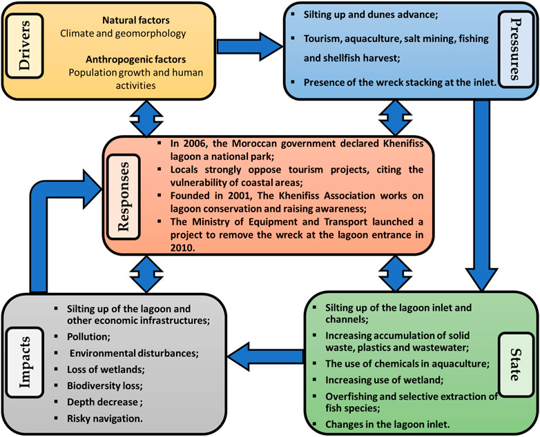
The main Drivers, Pressures, States, Impacts, and Responses identified in the KL and listed in Figure 8 are similar to those found in other Moroccan and North African lagoons (Maanan et al., 2014; El Mahrad et al., 2020; Bouchkara et al., 2021). Driving forces are both anthropogenic and natural. Pressures related to anthropogenic factors are particularly population growth, which causes an increase in human needs as well as economic and industrial growth, while those related to natural factors are primarily aeolian dune migration along the area and lagoon silting up. The general silting that affects the lagoon influences the hydrodynamic circulation within the lagoon. Changes in hydrodynamic circulation in a lagoon can have complex effects on the ecosystem, influencing the distribution of nutrients, oxygen levels, sedimentation patterns, salinity, and other physical and chemical characteristics that form the basis of high productivity, ultimately impacting the overall health and sustainability of the ecosystem (e.g., Panigrahi et al., 2009; Newton et al., 2018).
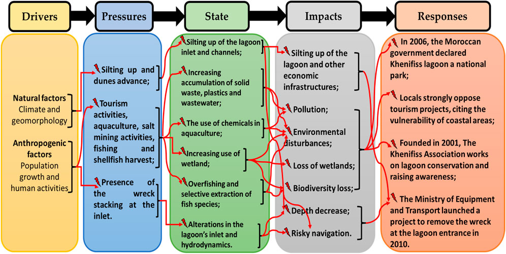
Figure 8. The main drivers, pressures, states, impacts, and responses on the KL.
Compared to other Moroccan lagoons, the KL is still regarded as the most well-preserved lagoon in Morocco, with no significant changes detected in its condition (El Mahrad et al., 2020). Thanks to the legal situation, the small size of the indigenous human population and limited access to the KL ecosystem, as well as increased civil society awareness, anthropogenic activities and their threats to the wetland, are less of a concern compared to other Moroccan lagoons (El Mahrad et al., 2020). However, the results of this study are alarming, as they highlight an escalating trend of solid and plastic waste accumulation in three specific areas that cover approximately 451 ha. These zones account for 7% of the lagoon’s overall surface area. Floating waste is occasionally visible on the shoreline and afloat in the water, creating an eyesore and posing a potential threat to the ecosystem. This visual pollution not only affects the aesthetic appeal of the lagoon but also has detrimental effects on tourism, which can be a vital source of income for local communities. The presence of plastics trapped in the sediments carries potential impacts, especially if they are mobilized and introduced into the biota, subsequently entering the food chain. Consequently, this poses a threat to the wildlife in the area, as it can be mistaken for food by birds, fish, and other animals, leading to injury or death. Additionally, the field observations have also reported frequent disturbances of birds and other wildlife in the area by human activity, such as noise and intrusion into their nesting and feeding areas. This can cause stress, displacement, and disruption of their natural behaviors, leading to a decline in their populations (Newton, 1998). Also, the observed decline in the fish population, caused by human fishing, and the probable reduction in the lagoon’s depth could be contributing factors to the decrease in the number of birds. Since fish are a significant source of food, the decrease in their availability may be impacting the bird population (Newton, 1998; Elliott et al., 2002). The dwindling population of fish and sea birds has the potential to disrupt the food chain and upset the delicate balance of the marine ecosystem (Elliott et al., 2002; Cury et al., 2003). Therefore, it is essential to conduct urgent research on these issues and take action to prevent further damage while promoting the conservation of the diverse wildlife in the region.
The study shows that the expansion of salt mining areas in the Sebkha of Tarza over time has resulted in the loss of wetlands in the upstream zone of the lagoon, with potentially significant impacts on the ecosystem. It is essential to address this issue with sustainable solutions to ensure the long-term sustainability of the lagoon’s ecosystem.
We strongly recommend conducting a comprehensive study on chemical pollution in the lagoon, with a particular focus on the impact of anthropogenic activities such as salt mining. This study should aim to identify the sources, types, and levels of chemical contaminants present in the water and sediment of the lagoon, as well as their potential impacts on the local ecosystem and human health.
Although the population surrounding KL is relatively small, the increasing population and unregulated human activities, in the absence of appropriate and sustainable management strategies, pose a significant threat to the environmental integrity of the lagoon. An illustrative example is the Oualidia Lagoon (north Atlantic coast of Morocco), which has experienced a significant increase in population from 7,741 in 1971–18,616 in 2014, causing several environmental problems such as wetland loss, biodiversity decline, excessive fertilizer, and pesticide use, overexploitation of aquaculture resources, and pollution (Bouchkara et al., 2021).
4.6 Challenges and strategies for managing and conserving the KL
Managing coastal lagoons is a challenging task that arises from multiple factors, including a limited understanding of the ecosystems, the involvement of multiple stakeholders, intricate social and administrative structures, and the allocation of responsibilities (Pérez-Ruzafa and Marcos, 2008). Additionally, in Morocco, the creation of protected areas has been implemented without sufficient engagement of the local populations that are affected by them, resulting in conflicts (Goeury, 2010). In the case of the KL, conflict has arisen between local authorities, private investors, and the local population over the proposed tourism development around the lagoon. To resolve such conflict, a stakeholder forum should be convened, and the local population should be involved through a participatory approach to reaching an agreement on ecosystem management that balances conservation and economic and social development imperatives (Newton and Elliott, 2016).
Moroccan lagoons have been the subject of many human responses to environmental problems. In the Oualidia lagoon, a sediment trap was built in 2011 to address many issues, including the asymmetrical nature of tidal propagation, the confinement of upstream waters, and the reduction in depth (Bouchkara et al., 2021). The lagoon’s hydrodynamics have improved as a result of the sediment trap’s implementation (Bouchkara et al., 2021). In the Nador lagoon, the Moroccan government has implemented a depollution program to mitigate pollution in the lagoon. Concurrently, significant infrastructure projects have been undertaken, including the closure of the existing inlet and the creation of a new inlet that is wider and deeper, thereby improving hydrodynamics and enhancing the overall health of the ecosystem (Maicu et al., 2021). These examples illustrate the positive effects of implementing appropriate management strategies on enhancing the conditions of coastal ecosystems. In the case of KL, despite the urgency of the situation, there have only been a few management responses in the past. However, the circulation within the lagoon is still negatively impacted, especially because of the presence of a sizable wreck blocking the inlet. Therefore, the removal of the wreck at the lagoon entrance is an urgent priority that is essential for ensuring safe navigation in the area and for maintaining a consistent supply of seawater to the salt flats. It is also critical for improving the water quality of the lagoon by facilitating water renewal and nutrient supply. The presence of the wreck can create hazards for boats and ships navigating through the area and can impede the flow of water into the lagoon, thereby negatively impacting its ecology and water quality. By removing the wreck, we can prevent accidents and enhance the overall health of the lagoon. It is also important to consider the impact of the wreck on the salt flats, which depend on a regular supply of seawater for their production.
The designation of the lagoon and its surroundings as a national park since 2006 has contributed to the preservation of its existing state. Nevertheless, anthropogenic activities, including tourism, aquaculture, fishing, harvesting, and salt mining, should be closely monitored and controlled to avoid potential disruptions to ecosystem components and biodiversity. Also, natural resources must be managed rationally to provide a stable and sustainable source of income for local populations.
It is critical to take urgent measures to improve the water quality and overall health of the ecosystem in the lagoon watershed communities. These measures should include implementing proper sanitation facilities, promoting waste sorting and recycling, and treating domestic and industrial waste before discharge. These actions will help mitigate the risk of water-borne illnesses and safeguard the plants and animals in the lagoon. By implementing these measures, significant progress can be made toward achieving the United Nations’ Sustainable Development Goals (SDGs) 11, 14, and 15. Specifically, access to basic sanitation can be enhanced, and the wellbeing of aquatic and terrestrial organisms can be safeguarded.
To ensure the long-term sustainability of the ecosystem of the lagoon and the livelihoods of the local communities, it is crucial to implement sustainable solutions. Responsible mining practices need to be implemented in the Sebkha of Tarza, where salt mining activities are taking place, prioritizing the protection of the environment and the restoration of wetlands that have been destroyed. This can be achieved in line with the United Nations’ Sustainable Development Goals (SDGs) 12, 13, and 15, which aim to promote responsible consumption and production, combat climate change, and protect biodiversity and ecosystems. Implementing eco-friendly mining techniques, efficient water management practices, and proper disposal of waste and tailings are some of the measures that can be adopted.
Future development projects planned for the lagoon must include an awareness program for the local population, local schools, fishermen, tourists, and salt miners about the preservation of natural resources. These programs can help educate and raise awareness about the importance of the lagoon’s ecosystem and the role that each individual can play in preserving it. Awareness programs can include a variety of educational materials, such as brochures, posters, and interactive displays that inform people about the different types of plants and animals that live in the lagoon, as well as the ecological processes that take place there. They can also include workshops, guided tours, and other activities that allow people to experience the lagoon firsthand and learn about the importance of preserving it.
5 Conclusion
The integrated environmental assessment of the KL within the DPSIR framework carried out in the present study reveals that the lagoon and its surrounding environment are exceptional natural sites that face issues from two categories of stressors, which are natural stressors and anthropogenic stressors. All of these stressors have a cumulative impact on the physicochemical and biological properties of the lagoon, resulting in ecosystem changes.
This study is harmonized with Sustainable Development Goal 14 of the 2030 Agenda, which seeks to conserve and sustainably use the oceans, seas, and marine resources for sustainable development. Additionally, it aligns with the first objective of the Intergovernmental Oceanographic Commission (IOC) of UNESCO, which aims to achieve healthy oceans and sustained ocean ecosystem services by improving scientific understanding of ocean ecosystems, identifying robust indicators of their health, and understanding ecosystem vulnerability. Therefore, this study serves as a call to action for the preservation of the fragile and unique ecosystem of the KL, promoting sustainable development practices, raising awareness, and encouraging the responsible management of the lagoons and their surroundings.
Due to the scarcity of scientific sources for reference, more research is needed to better understand the hydrodynamics and sedimentology of the KL, particularly in its entrance area, which is critical to the lagoon’s survival. It is also critical to investigate the interactions between these factors and the lagoon’s overall ecosystem. Further studies must also focus on quantifying the potential impact of land and biodiversity loss due to natural and human factors. Conducting these comprehensive studies will improve our scientific knowledge of this unique ecosystem and provide critical information for long-term management and conservation.
In general, using the DPSIR framework offers insightful analysis and suggestions for managing and conserving coastal lagoons. It assists in identifying significant key factors that affect the lagoon’s ecosystem, understanding how these factors interact, and appreciating their effects on the lagoon’s condition. This framework is a valuable tool for supporting policymakers and resource managers in creating efficient management strategies. It improves our comprehension of coastal ecosystems and makes it easier to take the necessary steps to safeguard and sustain these priceless environments.
Data availability statement
The raw data supporting the conclusion of this article will be made available by the authors, without undue reservation.
Author contributions
HE: Conceptualization, Data curation, Formal Analysis, Investigation, Methodology, Resources, Software, Validation, Visualization, Writing–original draft. AE: Formal Analysis, Supervision, Validation, Writing–review and editing. DN: Supervision, Writing–review and editing. MB: Writing–review and editing. KE: Writing–review and editing. BZ: Writing–review and editing. MU: Writing–review and editing. MA: Writing–review and editing.
Funding
The author(s) declare that no financial support was received for the research, authorship, and/or publication of this article.
Acknowledgments
The authors express their gratitude to the two referees and the Associate Editor JC for their valuable comments that enhanced and clarified the manuscript. Additionally, HE dedicates this work to his newborn son, wishing him a life filled with love, happiness, and success.
Conflict of interest
The authors declare that the research was conducted in the absence of any commercial or financial relationships that could be construed as a potential conflict of interest.
Publisher’s note
All claims expressed in this article are solely those of the authors and do not necessarily represent those of their affiliated organizations, or those of the publisher, the editors and the reviewers. Any product that may be evaluated in this article, or claim that may be made by its manufacturer, is not guaranteed or endorsed by the publisher.
References
Abioui, M., Abia, E. H., Benssaou, M., Ekoa Bessa, A. Z., and Abdelrahman, K. (2023). Iron–titanium sands of the Atlantic beaches between Tan-Tan and Tarfaya (southwest Morocco): characterisation and origin. Proc. Geol. Assoc. 134 (3), 329–343. doi:10.1016/j.pgeola.2023.04.003
Abioui, M., M’Barki, L., Benssaou, M., and Ezaidi, A. (2018). “Khnifiss lagoon-estuarine complex (Morocco): a coastal, marine, dune and Saharan ecosystem,” in ESW 3rd International Research Conference on Ecotourism & Environment, India, 29-31 July 2018, 28–29. Abstract book.
Adnani, M., Azzaoui, M. A., Elbelrhiti, H., Ahmamou, M., and Masmoudi, L. (2018). Investigation of reddening patterns of dune sands—the megabarchans of Al-ghord lahmar (khnifiss national park, south-west of Morocco). Catena 162, 230–244. doi:10.1016/j.catena.2017.11.008
Amimi, T., Elbelrhiti, K., Adnani, M., Elbelrhiti, H., Chao, J., and Oubbih, J. (2021). Soil map of Khnifiss lagoon and its surrounding environment. Arab. J. Geosci. 14 (6), 515. doi:10.1007/s12517-021-06932-8
Anthony, A., Atwood, J., August, P., Byron, C., Cobb, S., Foster, C., et al. (2009). Coastal lagoons and climate change: ecological and social ramifications in US Atlantic and Gulf coast ecosystems. Ecol. Soc. 14 (1), 8. doi:10.5751/es-02719-140108
Beaubrun, P. C. (1976). La lagune de Khnifiss: premières observations sur les sédiments et l’hydrologie du milieu. Bull. Inst. Sci. 1, 50–65.
Bidone, E. D., and Lacerda, L. D. (2004). The use of DPSIR framework to evaluate sustainability in coastal areas. Case study: Guanabara Bay basin, Rio de Janeiro, Brazil. Reg. Environ. Change 4 (1), 5–16. doi:10.1007/s10113-003-0059-2
Birch, G. F. (2011). “Indicators of anthropogenic change and biological risk in coastal aquatic environments,” in Treatise on estuarine and coastal science. Editors E. Wolanski, and D. McLusky (San Diego: Academic Press), 235–270. doi:10.1016/B978-0-12-374711-2.00411-3
Birch, G. F., and McCready, S. (2009). Catchment condition as a major control on the quality of receiving basin sediments (Sydney Harbour, Australia). Sci. Total Environ. 407, 2820–2835. doi:10.1016/j.scitotenv.2008.12.051
Bouchkara, M., Mejjad, N., El Khalidi, K., Canu, D. M., and Zourarah, B. (2021). An integrated environmental assessment of a coastal lagoon: the case of the Oualidia lagoon (Morocco). E3S Web Conf. 298, 02003. doi:10.1051/e3sconf/202129802003
Chapman, P. M. (2012). Management of coastal lagoons under climate change. Estuar. Coast. Shelf Sci. 110, 32–35. doi:10.1016/j.ecss.2012.01.010
Cury, P., Shannon, L., and Shin, Y. J. (2003). “The functioning of marine ecosystems: a fisheries perspective,” in Responsible fisheries in the marine ecosystem. Editors M. Sinclair, and G. Valdimarsson (Wallingford: CAB International), 103–123. doi:10.1079/9780851996332.0103
Cuzin, F. (2003). Les grands mammifères du Maroc méridional (Haut Atlas, Anti Atlas et Sahara): Distribution, écologie et conservation. France: Université Montpellier II. Doctoral dissertation.
Dakki, M., Chillasse, L., and El Agbani, M. A. (2003). “Fiche descriptive sur les zones humides Ramsar (FDR),” in Ramsar sites information service, convention on wetlands secretariat, gland, Switzerland.
Department of Water and Forestry (2008). Khenifiss national park - development and management plan 2008 – 2013. Rabat, Morocco: Ministry of Agriculture and Fisheries.
De Wit, R. (2011). “Biodiversity of coastal lagoon ecosystems and their vulnerability to global change,” in Ecosystems biodiversity Editors O. Grillo, and G. Venora (Rijeka: IntechOpen), 29–40. doi:10.5772/24995
El Behja, H., El M’rini, A., Nachite, D., and Abioui, M. (2024). Assessing the spatiotemporal transformation of a coastal lagoon inlet (1984–2019) using remote sensing and GIS: a study of Khenifiss Lagoon in Southern Morocco. Environ. Earth Sci. 83 (3), 122. doi:10.1007/s12665-024-11432-5
Elbelrhiti, H., Andreotti, B., and Claudin, P. (2008). Barchan dune corridors: field characterization and investigation of control parameters. J. Geophys. Res. Earth Surf. 113, F02S15. doi:10.1029/2007JF000767
Elbelrhiti, H., Claudin, P., and Andreotti, B. (2005). Field evidence for surface-wave-induced instability of sand dunes. Nature 437 (7059), 720–723. doi:10.1038/nature04058
Elliott, M., Burdon, D., Atkins, J. P., Borja, A., Cormier, R., De Jonge, V. N., et al. (2017). “And DPSIR begat DAPSI (W) R (M)!” -a unifying framework for marine environmental management. Mar. Pollut. Bull. 118 (1–2), 27–40. doi:10.1016/j.marpolbul.2017.03.049
Elliott, M., Hemingway, K. L., Costello, M. J., Duhamel, S., Hostens, K., Labropoulou, M., et al. (2002). “Links between fish and other trophic levels,” in Fishes in estuaries Editors M. Elliott, and K. L. Hemingway (Oxford: Blackwell Science), 124–216.
Elliott, M., and Whitfield, A. K. (2011). Challenging paradigms in estuarine ecology and management. Estuar. Coast. Shelf Sci. 94 (4), 306–314. doi:10.1016/j.ecss.2011.06.016
El Mahrad, B., Abalansa, S., Newton, A., Icely, J. D., Snoussi, M., and Kacimi, I. (2020). Social-environmental analysis for the management of coastal lagoons in North Africa. Front. Environm. Sci. 8, 37. doi:10.3389/fenvs.2020.00037
Eyring, V., Köhler, H. W., Van Aardenne, J., and Lauer, A. (2005). Emissions from international shipping: 1. The last 50 years. J. Geophys. Res. Solid Earth 110 (D17), D17305. doi:10.1029/2004JD005619
Fekhaoui, M., El Agbani, M. A., and Bayed, A. (1988). The Khnifiss lagoon and adjacent waters: chemistry of the surface waters. Rabat: Travaux de l’Institut Scientifique, 35.
Fiandra, M. (2020). DAPSI (W) R (M) problem-structuring framework applied to the Venice Lagoon. Venezia, Italy: Università Ca’Foscari Venezia. Master’s thesis.
Gabrielsen, P., and Bosch, P. (2003). Environmental indicators: typology and use in reporting. Copenhagen: European Environment Agency.
Goeury, D. (2010). “ONG et aires protégées au Maroc: L’endogénisation des politiques de protection de l’environnement, une dynamique multiforme,” in Maroc, Tourisme et développement local Editors M. G. Lucia, and H. Ramou (Torino: L’Harmattan), 312–325.
Gonenc, I. E., and Wolflin, J. P. (2004). Coastal lagoons: ecosystem processes and modeling for sustainable use and development. London: CRC Press.
Hammada, S. (2007). Etudes sur la végétation des zones humides du Maroc: Catalogue et analyse de la biodiversité floristique et identification des principaux groupements végétaux. Doctoral Dissertation. Rabat, Morocco: Mohammed V University.
Hassi, M., Alouani, M., Faaras, M. S., and Staiti, M. (2020). Qualitative and quantitative study of the spring phytoplankton community in the Naïla lagoon (Moroccan Atlantic coast). J. Mater. Environ. Sci. 11 (6), 977–987.
Haut Commissariat au Plan (2014). Recensement général de la population et de l’habitat 2014. Haut. Commis. au Plan. Rabat.
Idardare, Z., Chiffoleau, J. F., Moukrim, A., Ait Alla, A., Auger, D., Lefrere, L., et al. (2008). Metal concentrations in sediment and Nereis diversicolor in two Moroccan lagoons: khnifiss and Oualidia. Chem. Ecol. 24 (5), 329–340. doi:10.1080/02757540802378774
Kaur, M., Hewage, K., and Sadiq, R. (2020). Investigating the impacts of urban densification on buried water infrastructure through DPSIR framework. J. Clean. Prod. 259, 120897. doi:10.1016/j.jclepro.2020.120897
Kennish, M. J. (2001). Coastal salt marsh systems in the U.S.: a review of anthropogenic impacts. J. Coast. Res. 17 (3), 731–748.
Khenifiss Association (2022). Projet éco-touristique de l’association. Morocco: Khenifiss Association, Tarfaya.
Kjerfve, B. (1986). “Comparative oceanography of coastal lagoons,” in Estuarine variability Editor D. A. Wolfe (Massachusetts: Academic Press), 63–81. doi:10.1016/B978-0-12-761890-6.50009-5
Kjerfve, B., and Magill, K. E. (1989). Geographic and hydrodynamic characteristics of shallow coastal lagoons. Mar. Geol. 88 (3–4), 187–199. doi:10.1016/0025-3227(89)90097-2
Kristensen, P. (2004). “The DPSIR framework,” in Workshop on a comprehensive/detailed assessment of the vulnerability of water resources to environmental change in Africa using river basin approach. UNEP Headquarters, Nairobi, Kenya, 27–29 September 2004.
Lakhdar Idrissi, J., Orbi, A., Zidane, F., Hilmi, K., Sarf, F., Massik, Z., et al. (2004). Organisation et fonctionnement d’un écosystème côtier du Maroc: la lagune de Khnifiss. J. Water Sci. 17 (4), 447–462. doi:10.7202/705542ar
Lakhdar Idrissi, J., Sarf, F., El Mossaoui, N., Orbi, A., and Hilmi, K. (2000). Etude pluridisciplinaire de la lagune de Khnifiss (Sud du Maroc). Rapp. Trav. Doc. 108, 114p.
Lefrere, L., Ouassas, M., Guillois, B., Gillet, P., and Moukrim, A. (2015). Macrobenthic community structure of soft-bottom sediments in the Khnifiss lagoon, South of Morocco. J. Mat. Environ. Sci. 6 (11), 2226–2236.
Lewison, R. L., Rudd, M. A., Al-Hayek, W., Baldwin, C., Beger, M., Lieske, S. N., et al. (2016). How the DPSIR framework can be used for structuring problems and facilitating empirical research in coastal systems. Environ. Sci. Policy 56, 110–119. doi:10.1016/j.envsci.2015.11.001
Lin, T., Xue, X. Z., and Lu, C. Y. (2007). Analysis of coastal wetland changes using the “DPSIR” model: a case study in Xiamen, China. Coast. Manage. 35 (2–3), 289–303. doi:10.1080/08920750601169592
Long, E. R., Field, L. J., and MacDonald, D. D. (1998). Predicting toxicity in marine sediments with numerical sediment quality guidelines. Environ. Toxicol. Chem. 17 (4), 714–727. doi:10.1002/etc.5620170428
Long, E. R., MacDonald, D. D., Severn, C. G., and Hong, C. B. (2000). Classifying probabilities of acute toxicity in marine sediments with empirically derived sediment quality guidelines. Environ. Toxicol. Chem. 19 (10), 2598–2601. doi:10.1002/etc.5620191028
Long, E. R., Macdonald, D. D., Smith, S. L., and Calder, F. D. (1995). Incidence of adverse biological effects within ranges of chemical concentrations in marine and estuarine sediments. Environ. Manage. 19 (1), 81–97. doi:10.1007/BF02472006
Long, E. R., and Sloane, G. M. (2004). “Development and use of assessment techniques for coastal sediments,” in Estuarine indicators Editor S. A. Bortone (Boca Raton: CRC Press), 85–100. doi:10.1201/9781420038187
Maanan, M., Ruiz-Fernandez, A. C., Maanan, M., Fattal, P., Zourarah, B., and Sahabi, M. (2014). A long-term record of land use change impacts on sediments in Oualidia lagoon, Morocco. Int. J. Sediment. Res. 29 (1), 1–10. doi:10.1016/S1001-6279(14)60017-2
Macdonald, D. D., Carr, R. S., Calder, F. D., Long, E. R., and Ingersoll, C. G. (1996). Development and evaluation of sediment quality guidelines for Florida coastal waters. Ecotoxicology 5 (4), 253–278. doi:10.1007/BF00118995
Mahapatro, D., Panigrahy, R. C., and Panda, S. (2013). Coastal lagoon: present status and future challenges. Int. J. Mar. Sci. 3 (23), 178–186. doi:10.5376/ijms.2013.03.0023
Maicu, F., Abdellaoui, B., Bajo, M., Chair, A., Hilmi, K., and Umgiesser, G. (2021). Modelling the water dynamics of a tidal lagoon: the impact of human intervention in the Nador Lagoon (Morocco). Cont. Shelf Res. 228, 104535. doi:10.1016/j.csr.2021.104535
Maxim, L., Spangenberg, J. H., and O'Connor, M. (2009). An analysis of risks for biodiversity under the DPSIR framework. Ecol. Econ. 69 (1), 12–23. doi:10.1016/j.ecolecon.2009.03.017
McCarthy, E. (2007). International regulation of underwater sound: establishing rules and standards to address ocean noise pollution. Boston: Kluwer Academic Publishers.
Mejjad, N., Laissaoui, A., Fekri, A., Benmhammed, A., El Hammoumi, O., and Cherif, E. K. (2020). “Does human activities growth lead to biodiversity loss in the Moroccan coastal lagoons? A diagnostic comparison study,” in Proceedings of the 4th Edition of International Conference on Geo-IT and Water Resources 2020, 1–5.
Millennium Ecosystem Assessment (2005). Ecosystems and human well-being: synthesis. Washington, DC: Island Press.
Mimouni, R., Yacoubi, B., and Eddabra, R. (2005). Etude de la qualité microbiologique et physico-chimique de la lagune de Khnifiss. Rapp. Sci. Du. Programme LagMar Maroc. 1, 67–73.
Ministry of Equipment and Transport (2010). Protection of the lagoon environment. Ministry Equip. Transp. Rabat.
Mirari, S., Aoulad-Sidi-Mhend, A., and Benmlih, A. (2020). Geosites for geotourism, geoheritage, and geoconservation of the Khnefiss National Park, southern Morocco. Sustainability 12 (17), 7109. doi:10.3390/su12177109
Mishra, A. K., and Apte, D. (2021). The current status of Halophila beccarii: an ecologically significant, yet vulnerable seagrass of India. Ocean. Coast. Manag. 200, 105484. doi:10.1016/j.ocecoaman.2020.105484
Mishra, A. K., and Farooq, S. H. (2022). Lack of ecological data hinders management of ecologically important saltmarsh ecosystems: a case study of saltmarsh plant Porterasia coarctata (Roxb). J. Environ. Manag. 321, 115957. doi:10.1016/j.jenvman.2022.115957
Moll, S., Skovgaard, M., and Schepelmann, P. (2005). Sustainable use and management of natural resources. Copenhagen (Denmark): European Environment Agency.
National Agency of Water and Forests (2022). National Parks. Khenifiss National Park. Rabat, Morocco: National Agency of Water and Forests.
Newton, A., Brito, A. C., Icely, J. D., Derolez, V., Clara, I., Angus, S., et al. (2018). Assessing, quantifying and valuing the ecosystem services of coastal lagoons. J. Nat. Conserv. 44, 50–65. doi:10.1016/j.jnc.2018.02.009
Newton, A., and Elliott, M. (2016). A typology of stakeholders and guidelines for engagement in transdisciplinary, participatory processes. Front. Mar. Sci. 3, 230. doi:10.3389/fmars.2016.00230
Niemi, G., Wardrop, D., Brooks, R., Anderson, S., Brady, V., Paerl, H., et al. (2004). Rationale for a new generation of indicators for coastal waters. Environ. Health Perspect. 112 (9), 979–986. doi:10.1289/ehp.6903
Orbi, A., and Nemmaoui, M. (1992). Fluctuation des vents et variabilité de l’upwelling le long de la côte Atlantique marocaine. Rapport No.75. Casablanca, Morocco: INRH, 50.
Oulehri, T. (1992). Etude géodynamique des migrations de sables éoliens dans la Province de Laayoune (Nord du Sahara marocain). Paris, France: Paris 6 University. Doctoral Dissertation.
Pagan, J., Pryor, M., Deepa, R., Grace, J., Mbuya, O., Taylor, R., et al. (2020). Sustainable development tool using meta-analysis and DPSIR framework — application to savannah river basin, U.S. U.S. J. Am. Water Resour. Assoc. 56 (6), 1059–1082. doi:10.1111/1752-1688.12872
Panigrahi, S., Wikner, J., Panigrahy, R. C., Satapathy, K. K., and Acharya, B. C. (2009). Variability of nutrients and phytoplankton biomass in a shallow brackish water ecosystem (Chilika Lagoon, India). Limnology 10 (2), 73–85. doi:10.1007/s10201-009-0262-z
Pérez-Ruzafa, A., and Marcos, C. (2005). “Pressures on Mediterranean coastal lagoons as a consequence of human activities,” in Flooding and environmental challenges for Venice and its lagoon: state of knowledge Editors C. Fletcher, T. Spencer, J. Da Mosto, and P. Campostrini (Cambridge: Cambridge University Press), 545–555.
Pérez-Ruzafa, A., and Marcos, C. (2008). “Coastal lagoons in the context of water management in Spain and europe,” in Sustainable use and development of watersheds Editors İ. E. Gönenç, A. Vadineanu, J. P. Wolflin, and R. C. Russo (Dordrecht: Springer), 299–321. doi:10.1007/978-1-4020-8558-1_18
Pérez-Ruzafa, A., Marcos, C., and Pérez-Ruzafa, I. M. (2011). Mediterranean coastal lagoons in an ecosystem and aquatic resources management context. Phys. Chem. Earth Parts A/B/C 36 (5), 160–166. doi:10.1016/j.pce.2010.04.013
Pérez-Ruzafa, A., Pérez-Ruzafa, I. M., Newton, A., and Marcos, C. (2019). “Coastal lagoons: environmental variability, ecosystem complexity, and goods and services uniformity,” in Coasts and estuaries Editors E. Wolanski, J. W. Day, M. Elliott, and R. Ramachandran (Amsterdam: Elsevier), 253–276. doi:10.1016/B978-0-12-814003-1.00015-0
Radi, M., Laghzaoui, E. M., El Hamoumi, R., Qninba, A., Rihane, A., and Dakki, M. (2022). Greater Flamingo (Phoenicopterus roseus) breeding again in Morocco after more than half a century. Go-South Bull. 19, 33–36.
Rihane, A., El Hassan, E. L., and Dakki, M. (2023). Monitoring the breeding of the Greater Flamingo Phoenicopterus roseus at the Khnifiss Lagoon, southern Morocco. Go-South Bull. 20, 43–48.
Rodrigues-Filho, J. L., Macêdo, R. L., Sarmento, H., Pimenta, V. R. A., Alonso, C., Teixeira, C. R., et al. (2023). From ecological functions to ecosystem services: linking coastal lagoons biodiversity with human well-being. Hydrobiologia 850, 2611–2653. doi:10.1007/s10750-023-05171-0
Roy, M. B., Roy, P. K., Samal, N. R., and Mazumdar, A. (2012). Socio-economic valuations of wetland based occupations of lower gangetic basin through participatory approach. Environ. Nat. Resour. Res. 2 (4), 30–44. doi:10.5539/enrr.v2n4p30
Saltani, Z., Benmohammadi, A., and Belabed, M. (2015). Origine du phénomène d’ensablement déduite par combinaison entre télédétection et techniques sédimentologiques: application au bassin côtier de Tarfaya, sud-ouest marocain. Afr. Sci. 11 (1), 268–276.
Sauermann, G., Rognon, P., Poliakov, A., and Herrmann, H. J. (2000). The shape of the barchan dunes of Southern Morocco. Geomorphology 36 (1–2), 47–62. doi:10.1016/S0169-555X(00)00047-7
Tagliapietra, D., Aloui-Bejaoui, N., Bellafiore, D., De Wit, R., Ferrarin, C., Gamito, S., et al. (2011). The ecological implications of climate change on the Lagoon of Venice. Venice: UNESCO Venice Office and ISMAR-CNR.
Takyi, R., El Mahrad, B., Nunoo, F. K. E., Adade, R., ElHadary, M., and Essandoh, J. (2022). Adaptive management of environmental challenges in West African coastal lagoons. Sci. Total Environ. 838, 156234. doi:10.1016/j.scitotenv.2022.156234
Thomas, R. (1995). A general strategy for integrated environmental assessment at the European Environment Agency. Bilthoven: National Institute of Public Health and Environment.
Tnoumi, A., Angelone, M., Armiento, G., Caprioli, R., Crovato, C., De Cassan, M., et al. (2021). Assessment of trace metals in sediments from khnifiss lagoon (Tarfaya, Morocco). Earth 2 (1), 16–31. doi:10.3390/earth2010002
Tnoumi, A., Angelone, M., Armiento, G., Caprioli, R., Crovato, C., De Cassan, M., et al. (2022). Heavy metal content and potential ecological risk assessment of sediments from Khnifiss Lagoon National Park (Morocco). Environ. Monit. Assess. 194 (5), 356. doi:10.1007/s10661-022-10002-1
Keywords: coastal wetland, ecosystem services, environmental assessment, sustainable development, coastal management, ecosystem management
Citation: El Behja H, El M’rini A, Nachite D, Bouchkara M, El Khalidi K, Zourarah B, Uddin MG and Abioui M (2024) Evaluating coastal lagoon sustainability through the driver-pressure-state-impact-response approach: a study of Khenifiss Lagoon, southern Morocco. Front. Earth Sci. 12:1322749. doi: 10.3389/feart.2024.1322749
Received: 16 October 2023; Accepted: 08 May 2024;
Published: 21 June 2024.
Edited by:
José Lino Vieira De Oliveira Costa, University of Lisbon, PortugalReviewed by:
Amrit Mishra, James Cook University, AustraliaTania Russo, University of Naples Federico II, Italy
Copyright © 2024 El Behja, El M’rini, Nachite, Bouchkara, El Khalidi, Zourarah, Uddin and Abioui. This is an open-access article distributed under the terms of the Creative Commons Attribution License (CC BY). The use, distribution or reproduction in other forums is permitted, provided the original author(s) and the copyright owner(s) are credited and that the original publication in this journal is cited, in accordance with accepted academic practice. No use, distribution or reproduction is permitted which does not comply with these terms.
*Correspondence: Hamza El Behja, aGFtemEuZWxiZWhqYUBldHUudWFlLmFjLm1h
†ORCID: Hamza El Behja, orcid.org/0009-0006-6835-6857; Abdelmounim El M’rini, orcid.org/0000-0002-7963-5660; Mohamed Abioui, orcid.org/0000-0002-6331-1442