 Murat Şentürk
- Geological Engineering Department, Süleyman Demirel University, Isparta, Türkiye
The Küplüce-Gökçesu Basin, located in northwestern Anatolia, is an Eocene-aged shallow marine basin known for its rich carbonaceous sediments. The basin is underlined by Paleozoic metamorphic rocks, granites from the Sakarya Massif, and Jurassic-Upper Cretaceous turbiditic and carbonate rocks. The sedimentary deposits in the basin consist of two main lithological units, namely, the Tokmaklar and Sazlar Formations. The Tokmaklar Formation comprises marl, bituminous marl, clayey bituminous limestone, Nummulite limestone, and marl-clay-sandstone successions. Economic coal formations are found at the base of the Tokmaklar Formation, along with bituminous limestone and marl. The Sazlar Formation is composed of thick layered sandy limestones and marls, deposited in reefal conditions. Previous studies conducted in the 1980 s estimated the coal reserves in the Küplüce-Gökçesu Basin to be around 40 million tons. However, this study reveals the discovery of a new coal seam that was not previously identified, with a potential thickness of approximately 11 m. This discovery suggests that the coal reserves in the region could be significantly larger than previously known, potentially 5-6 times greater. The quality of the Küplüce-Gökçesu coals is classified as semi-bituminous hard coal of the lower bituminous coal group, based on chemical analysis results. This study contributes to the understanding of the geology and coal potential of Eocene basins in Anatolia and provides valuable information for future exploration and exploitation activities.
1 Introduction
Türkiye has emerged as a country with the highest energy import dependency among the Organization for Economic Co-operation and Development (OECD) nations in recent years (Ağbulut et al., 2021). As a result, the exploration and utilization of domestic energy resources have become crucial imperatives. Among these resources, coal holds significant importance as one of Türkiye’s primary domestic energy sources. The country boasts substantial coal reserves, estimated at approximately 21 billion tons, encompassing lignite, subbituminous coal, bituminous coal, and anthracite (TKI, 2020). The presence of coal formations predominantly in Neogene-Paleogene-aged basins underscores the importance of comprehensive knowledge about the geological characteristics and coal potential of these basins for effective energy planning and strategy.
Tertiary-aged coal formations in Türkiye are primarily deposited in basins ranging from the Pliocene to the Eocene period (Figure 1). While the Miocene-aged basins generally consist of sediments deposited in marine facies, a significant portion of the lignite reserves in Türkiye is found in basins located in western and central Anatolia, where terrestrial facies prevail. On the other hand, the Eocene-aged basins, characterized by turbiditic rocks, volcanic and pelagic carbonate rocks, were primarily formed in deep marine environments and are mostly situated in the south-southwestern Anatolian region. In contrast, the central-northern Anatolian region harbors reefal carbonate rocks and marine basins containing bitumen, bituminous shale, shale, sandstone, bituminous marl, marly limestone, and coalaceous components, primarily deposited in lagoonal environments (Büyükutku et al., 2005).
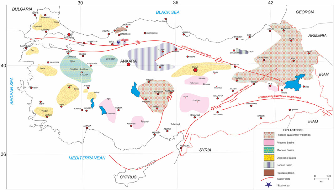
FIGURE 1. The geological location of the coal formations in Türkiye (Şentürk, 2022).
Among the various basins in Türkiye, the Küplüce-Gökçesu-Mengen basin has been extensively studied due to its distinctive geological structure and potential energy resources (Atalay, 2001; Koç and Türkmen, 2002; Sarı et al., 2004; Büyükutku et al., 2005; Koç et al., 2008; Doğan, 2013; Hoş-Çebi and Korkmaz, 2013; Şentürk, 2022). However, despite numerous studies on the Küplüce-Gökçesu Eocene basin, there is still a dearth of information regarding its coal potential. Previous studies have primarily focused on the basin’s geological structure, coal formation, and chemical properties. However, important aspects such as the continuity, lateral variation, and the influence of Eocene conditions on coal seams in the basin remain insufficiently investigated. This study aims to address these gaps by conducting a detailed examination of the geological characteristics and coal potential of the Küplüce-Gökçesu Eocene basin. Through this investigation, we aim to gain a better understanding and evaluation of this basin, which serves as a vital energy production source in Türkiye. To achieve this objective, our study will test the following hypotheses: 1) The continuity of the coal seams identified in drilling studies conducted by the General Directorate of Mineral Research and Exploration (MTA) and Turkish Coal Enterprises Institution (TKI) in the basin is also evident in the Küplüce-Gökçesu section. 2) There are lateral stratigraphic and sedimentological variations among the coal seams documented in previous studies and potential newly discovered coal layers. 3) The Eocene conditions have influenced the coal formation process within the basin.
2 Geological background
The Küplüce-Gökçesu basin is in Bolu province in northern Anatolia. The basin is located west of the Pontides, NE of the Bolu Massif and approximately 13 km north of the segmental components that form the southern boundary of the North Anatolian Fault Zone (Figures 1, 2).
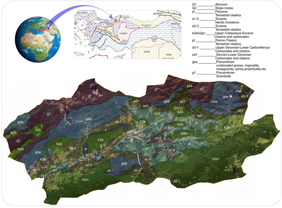
FIGURE 2. On the satellite image based on Google Earth (Google Earth, version 7.3.6), the location and geology of Küplüce-Gökçesu-Mengen basin are depicted, along with a simplified tectonic map showing the major sutures and continental blocks in the Eastern Mediterranean region (adapted from Okay and Tüysüz, 1999).
All rock groups of igneous, metamorphic, and sedimentary origin ages ranging from the Ordovician to the Pliocene can be seen in and around the basin. The region consists of metamorphic massifs, sedimentary rocks, and volcanic rock lithologies. The tectonic framework of the region is determined by the orogenic-tectonic movements in the NW-SE direction. The region, which has the character of a pressure zone, is under the influence of thrust and reverse faults. The Küplüce-Gökçesu basin is an asymmetric graben structure bounded by NW-SE orientated normal and lateral thrust faults (Figure 3). Upper Cretaceous aged rocks bound the basin in the north and are tectonically overlain by Paleocene-aged sediments by a thrust fault. Under the influence of the thrust fault, the Paleocene aged units were folded and overturned synclinal structures with NE axis and inclined in this direction were formed. The sedimentary units deposited in the basin have gained great inclinations. Sazlar and Tokmaklar Formations represent the two sedimentary lithologies in the basin (Figure 4).
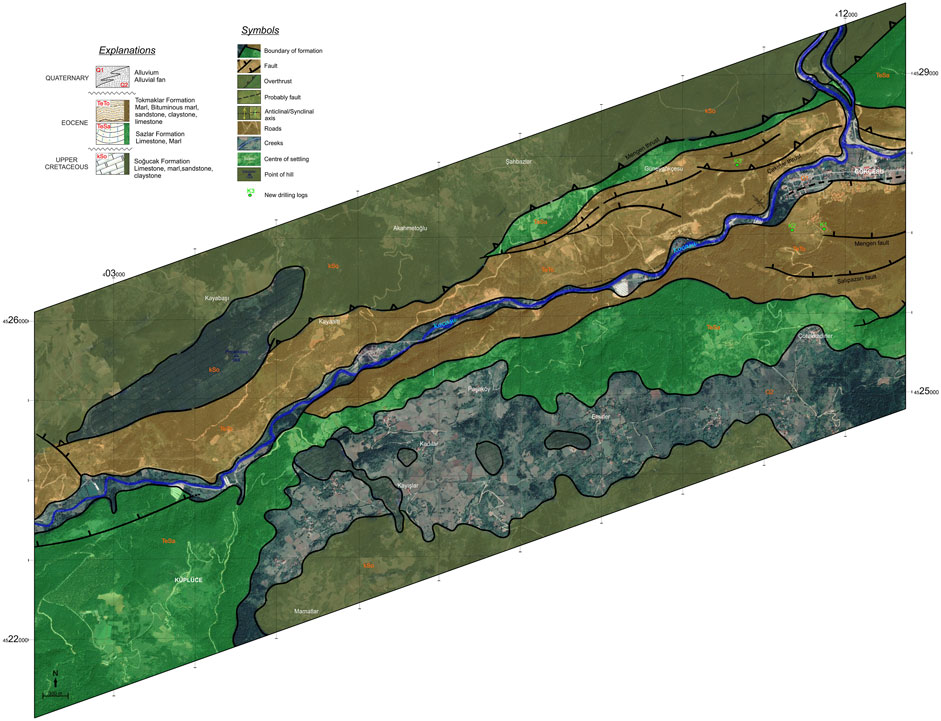
FIGURE 3. The appearance of formations in the Küplüce-Gökçesu basin on a Google Earth (Google Earth, version 7.3.6) based satellite image.
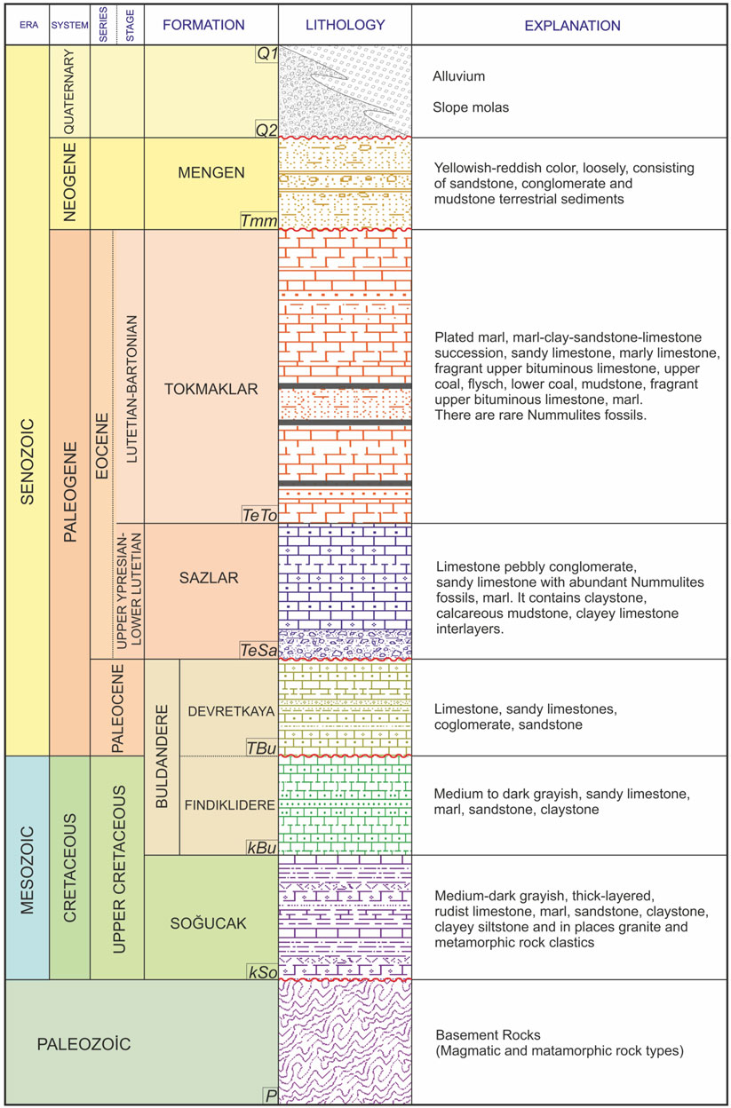
FIGURE 4. Generalized stratigraphic column section of the Küplüce-Gökçesu-Mengen coal basin (Şentürk, 2022).
2.1 Sazlar formation
The formation, which spreads in the NE-SW basin direction in the north and south of Kocasu Stream in the Küplüce-Gökçesu basin, was named and used for the first time by Sarı et al. (2004). The formation starts with white beige-colored Nummulites fossiliferous limestone conglomerates at the base. It continues with white-yellow colored, massive, dense Nummulites fossiliferous sandy limestone and marl succession towards the top. The stack ends with a folded, massive, and abundantly fossiliferous limestone lithology.
The sandy limestones forming the main component of the Sazlar Formation deposited in a reefal environment are grey-beige to white-yellow, thick to very thick and regularly stratified, massive in appearance. Nummulite fossils are dense enough to form biostrom-like organic accumulations. There are grey greenish to reddish marl levels on the sandy limestone. Nummulite fossils, such as coral, Brachiopoda, gastropods and Ostrea, are abundant in the stack, which also contains intermediate levels of claystone, clayey limestone, and mudstone. The age of the formation was determined as upper Ypresian-lower Lutetian based on foraminifera such as Nummulites burdigalensis (de la Harpe), Nummulites lucasi d’Archiac, Nummulites preaturicus Schaub, Alveolina sp., Assilina exponens (Sowerby), Nummulites obtusus (Sowerby), Assilina spira (de Roissy) (Cerit, 1983; Erdem and Akalın, 1983). According to the sandy limestone and marl lithologies it contains, the Sazlar Formation represents the transitional facies of the offshore reefal environment.
2.2 Tokmaklar formation
The formation, which consists of different lithological units and contains dense coalaceous components, was named for the first time by Kaya and Dizer (1981-1982a, b) in the Küplüce-Gökçesu basin, north and south of Kocasu Stream. The Tokmaklar Formation, which overlies the Sazlar Formation conformably and gradationally, consists of Nummulitic limestone, bituminous marl, lower bituminous limestone, coal, sandstone-claystone-marn succession, upper bituminous limestone, marly limestone, sandy fossiliferous limestone, and marl-claystone-sandstone succession lithologies (Figure 4).
Starting with grey-beige and yellow, partially crystallized, hard limestones containing abundant Nummulite fossils, the stack continues with green-colored massive and fossiliferous-marls lithology containing sandy levels towards the top. Over the fossiliferous marls, bituminous limestones with intense bitumen odour characterizing the lagoonal environment conditions are observed. The highly deformed, bituminous limestones with a 20–45 cm layer thickness is brown to grey beige. Clays and bituminous marls, which constitute the main component of the lithologies forming the Tokmaklar Formation, are medium-dark grey to dark grey, greenish, reddish, thin-medium layered and regularly laminated. Clay and marls are laterally continuous with sandstone, limestone, and gravel lithologies and contain abundant lignite veins and fossils. In the coals observed in succession with claystone, bituminous marl and bituminous limestones, the thickness of the layers varies between 20–50 cm, and the total thickness of the coal showing multiple layering can reach up to 15–18 m.
Sandstones, the other important component of the sandstone-claystone-marn succession, are weakly consolidated and carbonate cemented (see Liu et al., 2023). They are generally grey-beige to greenish, thin-medium layered, grained and poorly graded. Proximal sandstones, composed of material carried by turbiditic currents and structures such as load molds, crossbedding, and grain orientation, are commonly observed in the sandstone, which forms interbeds with claystone, marl, mudstone and occasionally pebble lithologies. The constituent grains in the calcarenite character sandstones are derived from igneous and metamorphic rocks of the pre-Paleocene Bolu massif, sedimentary clastic rocks, and Nummulitic limestones. The upper parts of the stack consist of marly limestone with abundant Nummulites fossils, sandy fossiliferous limestone, and marl-claystone-sandstone succession. Grey-greenish grey, laminated, bituminous layered marls overlie it.
Nummulites milleeaput Boubee, Assilina exponens (Sowerby), Discocyclina scalaris (Schlumberger), Assilina praespira Douvillei, Assilina mamillaîa d'Archiac, Nummulites uronensis var Paucigranulata Doncieux, Nummulites crassus Boubee, Nummulites uronensis var Platania Heim, Gypsine sp., Miliolidae, Rotalia sp., and Globigerina sp., the formation age was determined as Lutetian-Bartonian (Kaya and Dizer, 1981-1982a, b).
The stratigraphic sequence of the Tokmaklar Formation consists of bituminous marls with high organic matter content, Nummulitic limestone deposited in a reefal environment and accompanying clayey bituminous limestone and coal horizons.
This sequence shows that the Tokmaklar Formation was deposited in a lagoonal environment. In addition, microfossils such as foraminifera, ostracods, algae and peloids support lagoonal environmental conditions.
3 Materials and methods
3.1 Field studies
Field studies were conducted to investigate the geographical and topographical characteristics of the Küplüce-Gökçesu Basin. During the fieldwork, geological formations were observed, sampling points were determined, and the distribution of coal seams was mapped. The lithological and stratigraphic characteristics of formations such as the Sazlar Formation and Tokmaklar Formation, which are geological formations in the basin, were examined in detail.
3.2 Sample collection and analyses
3.2.1 Sample collection
The sampling process was carefully planned to ensure the accurate representation of coal seams in the Küplüce-Gökçesu Basin. Samples were selected from different regions and depths of the basin to create a general overview and observe the diversity of coal seams. In this study, some samples were taken from the Sazlar Formation, while others were taken from the Tokmaklar Formation. The samples were carefully collected during fieldwork and placed in airtight plastic bags. This process ensured the protection of samples from external factors and prevented contamination prior to analysis. Additionally, each sample was labeled and associated with its source to ensure accuracy and traceability during the analysis process.
3.2.2 Sample preparation
The collected samples were prepared according to the ASTM D2013 (ASTM, 2021) and ASTM D346 (ASTM, 2017) standards to make them suitable for analysis. Firstly, the samples were divided into small pieces and then pulverized to achieve a homogeneous structure. Approximately 1 g of pulverized sample was taken for analysis. The remaining sample quantity was stored in airtight containers. This storage process ensured the preservation of samples for future analyses and their proper preservation for quality control purposes.
3.2.3 Petrographic analyses
The mineralogical and petrographic properties of the samples were determined through detailed examinations under a microscope. For this purpose, thin sections were prepared from the samples and examined using a polarized light microscope. Petrographic analyses provided detailed information about the mineral composition, microscopic structures, and differences and similarities in coal formations.
3.2.4 Physical analyses
Physical analyses were performed to determine important parameters such as coal density, porosity, and water absorption capacity. Coal density was determined according to ASTM D167 (ASTM, 2017) standard, and the air-dry density, minimum density, and maximum density of the samples were calculated. Coal porosity was measured according to ASTM D4404 (ASTM, 2017) standard, and the effective porosity and total porosity of the samples were calculated. The water absorption capacity of coal was determined according to ASTM D570 (ASTM, 2018) standard, and the 24-h water absorption capacity of the samples was determined. These physical analyses provided important data to understand the behavior of coal in storage, transportation, and energy production processes.
3.2.5 Chemical analyses
Chemical analyses were conducted to determine critical properties of coal such as calorific value, sulfur content, ash content, hydrogen content, and carbon content. The calorific value was determined according to ASTM D5865 (ASTM, 2013) standard, and the lower and upper heating values of coal samples were determined. The sulfur content was measured according to ASTM D4239 (ASTM, 2017) standard, and the total sulfur content of the samples was determined. The ash content was determined using ASTM D7582 (ASTM, 2010) standard, and the macro thermogravimetric analysis was used to determine the ash content of the samples. The hydrogen content and carbon content were also determined using the same method. These chemical analyses provided important data to evaluate the efficiency of coal in energy generation, combustion characteristics, and environmental impact.
3.2.6 Energy potential analysis
Calorific values and hydrocarbon potential analysis were used to analyze the energy potential of coal samples in the Küplüce-Gökçesu Basin.
Calorific values represent the amount of heat produced per unit mass of a substance. The calorific values of coal are considered important parameters for energy production. The lower heating value represents the heat obtained when the water formed during combustion remains in the liquid phase, while the upper heating value represents the heat obtained when the water formed during combustion is vaporized. In this study, the lower and upper heating values of coal samples were determined using the ASTM D5865 standard test method. The LECO AC600 model oxygen bomb calorimeter device was used for calorific value determination.
Hydrocarbon Potential Analysis determines the number of hydrocarbons that can be obtained through gasification or liquefaction of coal. The higher the hydrocarbon potential, the higher the value of coal as an energy source. In this study, different reactors and catalysts were used for gasification and liquefaction of coal samples. Gasification reactions were performed at high pressure and temperature in an oxygen or air atmosphere. Liquefaction was carried out using the Fischer-Tropsch synthesis in a hydrogen atmosphere. A tube reactor was used for gasification reactions, while a Slurry Reactor was used for liquefaction. In these reactors, coal samples were subjected to reactions in suitable environments, and the obtained gas and liquid hydrocarbons were analyzed.
3.3 Exploration drilling
Previous drilling campaigns by the General Directorate of Mineral Research and Exploration (MTA) conducted between 1956 and 1987 were reviewed, and suitable areas for new exploration drilling were identified. Additional drilling was carried out in these areas. Vertical drilling sections provided valuable data about the presence, distribution, and quality of coal in the basin, enabling a more detailed analysis of the coal potential in the basin.
4 Discussion
4.1 Küplüce-Gökçesu eocene coals
4.1.1 Drilling logs
About 60 drillings between Merkeşler and Gökçesu (Bolu) and 15 drillings between Gökçesu and Mengen (Bolu) were carried out by the MTA between 1956–1983 and 1986–1987. These drillings revealed approximately 44 million tons of reserves (probable + apparent) in the Merkeşler-Gökçesu-Mengen region (Erdem and Akalın, 1983; Gürsoy, 1988).
Within the scope of the exploration, works were carried out to identify possible new coal seams, and exploration drillings (K1, K2, and K3) were drilled in different areas in the SE of Güneygökçesu (Figure 5). In the K1 and K2 exploration drillings drilled in the NE-SW of the Küplüce-Gökçesu basin, a stack (Tokmaklar Formation) consisting of Nummulite limestone and conformably overlying clastic sediments of the lagoonal environment was cut (Figure 6).
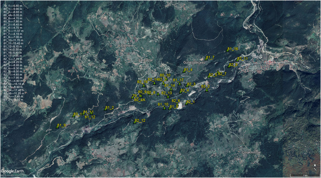
FIGURE 5. The locations of some coal-cutting drillings carried out by MTA between 1979 and 1983 in the Küplüce-Gökçesu region, along with the corresponding coal thickness values, are shown on the Google Earth image (Google Earth, version 7.3.6) (Karaca, 2000).
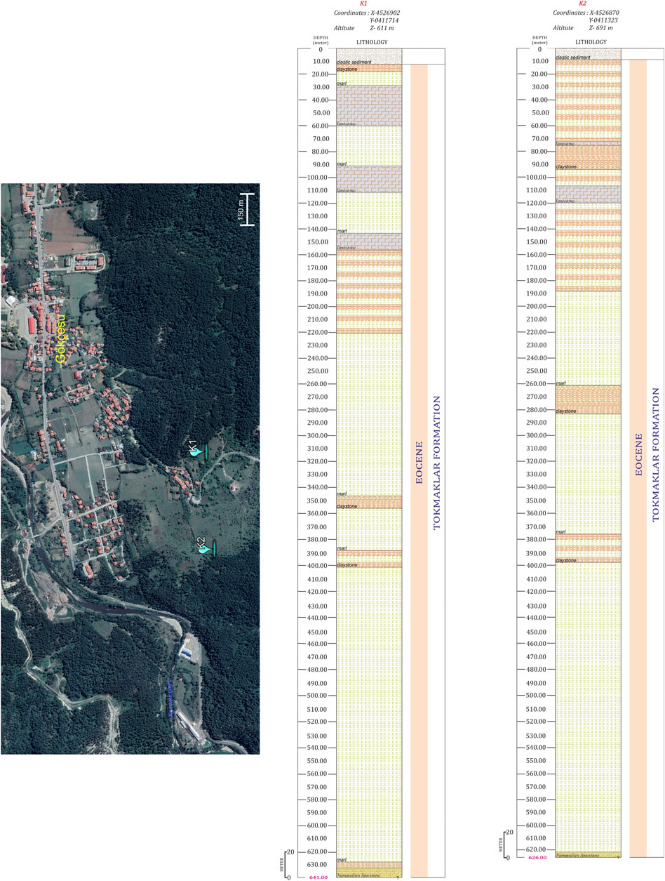
FIGURE 6. Locations and vertical sections of K1 and K2 drillings on Google Earth imagery (Google Earth, version 7.3.6).
The clastic sediments of the lagoonal environment cut in the exploration drillings consist of Nummulite fossiliferous limestone, marl and clayey-marly limestone components and contain abundant mudstone interbeds. The area south of the Kocasu Stream, where K1 and K2 exploration drillings were made, is structurally located between the Yörükler, Mengen and Salıpazarı faults, which consist of standard fault components orientated approximately D-W.
In the K3 exploration drilling drilled in the north of the Küplüce-Gökçesu Eocene basin, east of Güneygökçesu, a stack consisting of sandy fossiliferous limestones of the Sazlar Formation and the overlying Tokmaklar Formation consisting of Nummulites limestone, marly limestone, bituminous marl, marl, claystone lithologies was cut. Seams containing multiple coal horizons were encountered between 155.20–667.00 m. The coal exposed in three seams reaches a thickness of 5.80 m in the upper horizon (17.60 m), 10.50 m in the middle horizon (26.80 m) and 11.04 m in the lower horizon (26.00 m) (Figure 7).
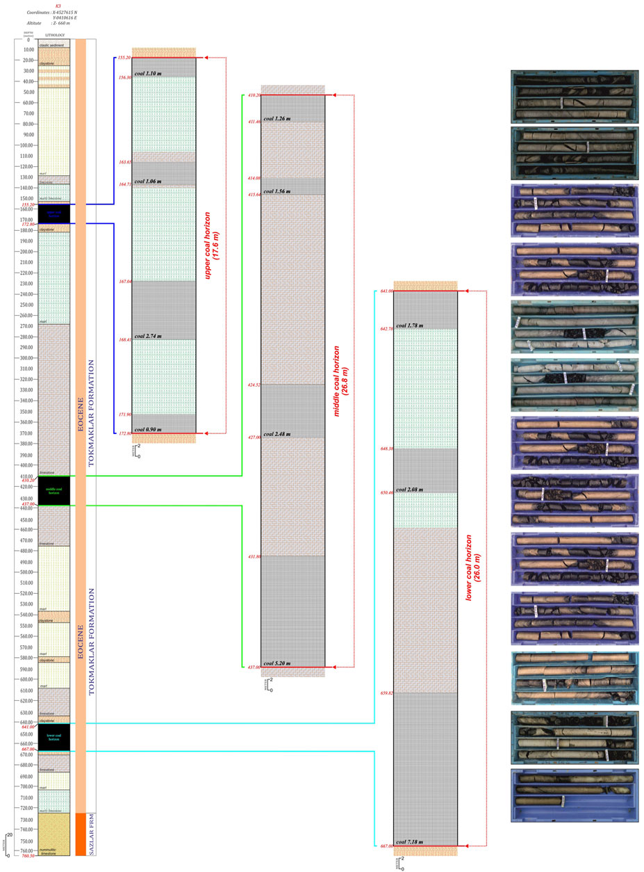
FIGURE 7. Vertical sections of the K3 drilling, the location of the coal seams and the view of some coal core samples.
4.1.2 Drilling works in The Küplüce-Gökçesu basin
During the drilling operations carried out by MTA and TKI for coal exploration in the Küplüce-Gökçesu region, the coaliferous components deposited in the lower-middle parts of the Eocene-aged Tokmaklar Formation reach a thickness of up to 150 m. Coal seams interbedded with claystone, marl, bituminous marl, and bituminous limestone show thickness variations between 20–50 cm, while total coal deposits within the coal horizon can reach up to 18 m thick.
The correlation study in the Küplüce-Gökçesu-Mengen region, including the old drillings for coal exploration and the K3 exploration drilling, has shown that in addition to the rapid facies’ changes in the basin, the folded and faulted structures in the coal-bearing sediments have significantly changed the thickness, extension, and quality of the coal horizon in the lateral direction (Figure 8).
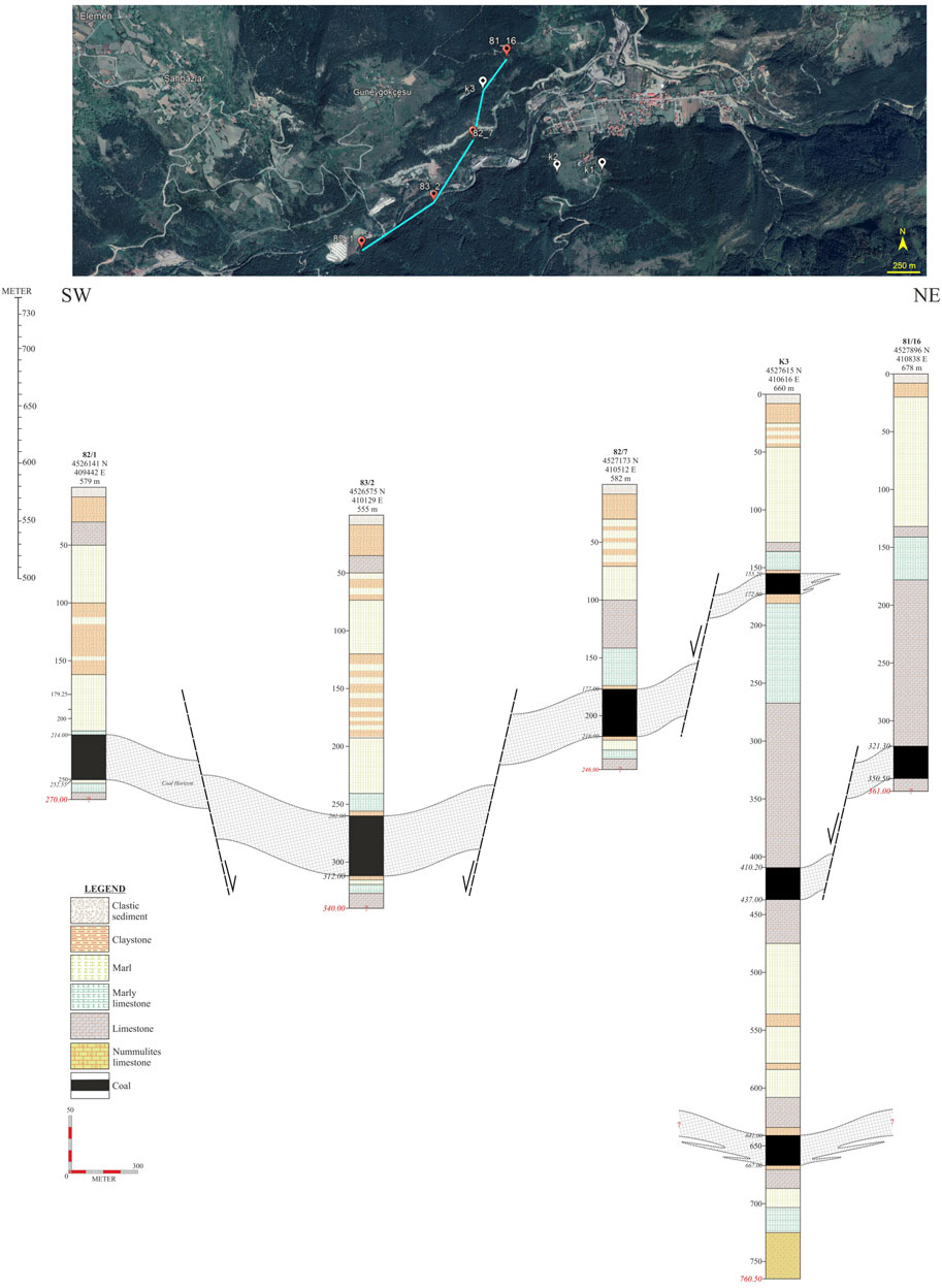
FIGURE 8. The NE-SW correlation of the soundings east of the Küplüce-Gökçesu basin, along with their locations on Google Earth (Google Earth, version 7.3.6).
It was observed that the thickness of the coal horizon in the eastern part of the Küplüce-Gökçesu basin reached up to 85 m, while it was 45 m thick in the Hacıahmetler-Mengen area in the east of the basin and thinned and terminated in the Demirciler-Mengen area due to rapid changes.
In exploratory drilling in Gökçesu (K1 and K2) and Güneygökçesu (K3), depths of 641.00 m (K1 drilling), 626.00 m (K2 drilling) and 760.50 m (K3 drilling) were reached. No coal beds were intersected in K1 and K2 drillings. The K3 drilling identified horizons containing potentially economic coal seams. From the three different coal horizons cut, approximately 750 thousand tons of reserves were calculated based on a thickness of 5.80 m in the upper seam (between 155.20–172.80 m), approximately 1 million 350 thousand tones based on a thickness of 10.50 m in the middle seam (between 410.20–437.00 m) and approximately 1 million 450 thousand tones (probable) based on a thickness of 11.04 m in the lower seam (between 641.00–667.00 m).
The depth of the lower coal horizon of the K3 exploration borehole, where multiple coal horizons were identified, could not be reached during the drilling activities carried out by public institutions and private companies for coal exploration in previous years. Therefore, the quality and thickness of the horizon is unknown. This cut horizon plays an essential role in determining the coal reserve of the region. The coal seam in this horizon has different characteristics from the others. It is crucial in terms of its character and potential to affect the coal potential of the region to a great extent.
The coals distributed in the Küplüce-Gökçesu coal-bearing Neogene basin are pre-dominantly dark greyish-blackish, bright to semi-bright, locally banded, complicated, and semi-friable-friable (Figure 7). When Küplüce-Gökçesu coals are analyzed macroscopically, it is observed that they are composed of vitrene and durite in lesser proportions and pre-dominantly clarite.
However, the results of the analyses of the samples containing coal indicate that the coals in the Küplüce-Gökçesu region may be in Class-C of the lower bituminous coal group (ASTM, 1991) (Table 1).
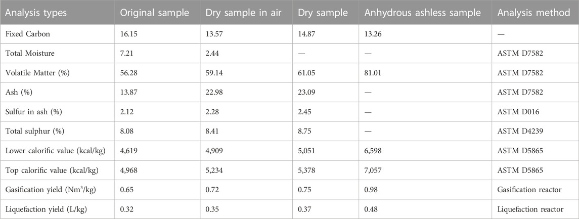
TABLE 1. Chemical analysis values of samples taken from coal lithologies of K3 drilling.
4.2 Facies features of the Küplüce-Gökçesu-Mengen basin
In the Küplüce-Gökçesu-Mengen Eocene basin, which also includes coal formation, two distinct facies were identified: (1) reefal and (2) lagoonal.
In the region, during the Ypresian age, sandy limestone and marl units with thick layers and abundant Nummulites fossils were deposited in the immediate marine environment. Following the sedimentation, a regression occurred, and a lagoonal facies environment developed, leading to the deposition of lower bituminous limestone and the initiation of coal formation. Towards the end of the coal formation process, with the transgression, the area was once again flooded, and clastic sediments with flysch characteristics were deposited. This resulted in the formation of new coal seams, and upper bituminous limestones were deposited as the conditions regressed back to a lagoonal environment.
The presence of marl, claystone, sandstone, and Nummulites limestones in these sediments indicates a transition to marine facies during this period.
The reefal facies sediments consist of components such as Nummulitic limestone, sandy-clay limestone, and calcareous mudstone. These sediments frequently contain Nummulite fossils, which exhibit a locally layered structure with grains typically oriented in a semi-parallel or parallel form. Biostromal limestones containing neritic foraminifers are present in a contracted microspar calcite matrix. Dunham (1962) describes these limestones as packstone and grainstone.
The facies-lithofacies changes observed in the NE-SW trending Eocene-aged depositional area indicate a transition from reefal carbonate rocks to clastic sediments, characterizing the transitional environment to the west of the depositional area. Biostrom-like organic accumulations and patch reefs are commonly observed on the side of the reef overlooking the lagoon (Figure 9).
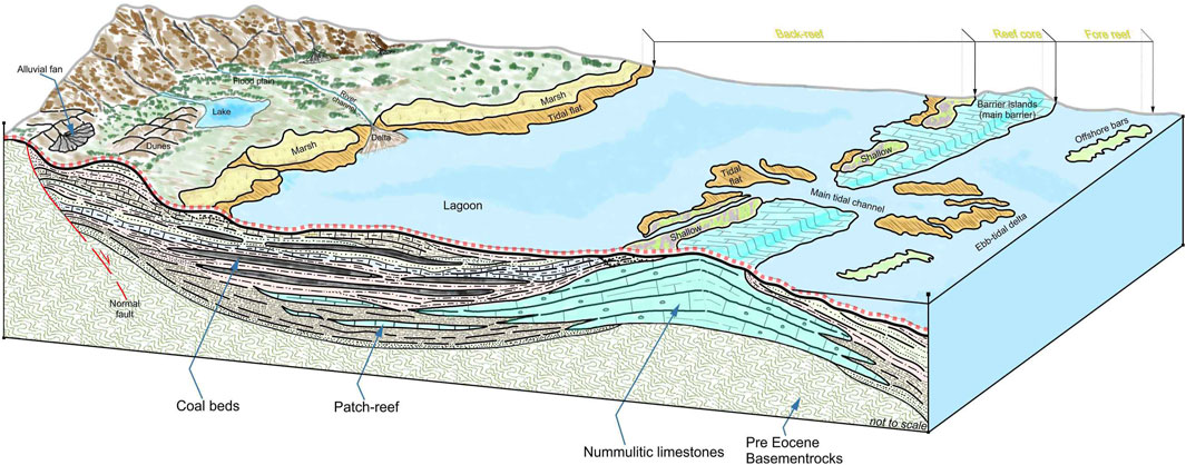
FIGURE 9. Formation model of coals in the Küplüce-Gökçesu-Mengen basin (Şentürk, 2022).
Sedimentary rocks deposited in the lagoonal facies consist of organic matter-rich lithologies such as bituminous marl, clayey bituminous limestone, marly limestone, and coal. Varv-type lamination and charred plant remains are standard in the lagoonal facies’ sediments. In the lower part of the Tokmaklar Formation, Varv-type lamination and charred plant remain, sedimentary components of tidal channels, are commonly found in the lagoonal facies’ sediments. In the lower part of the Tokmaklar Formation, the sedimentary components of the tidal channels consist of medium to well-graded sandstone, calcareous mudstone, conglomerate and bioclast mudstone. The grain size reduction orientated long axes, planar cross-bedding and binned pebble structure observed in these clastic rocks indicate the effect of tidal currents (see Wang et al., 2023). The clastic sediments from the tidal channels transition to marl, shale, and mudstone rich in organic matter over short distances. The marly limestone, bituminous marl, and clayey bituminous limestone, which are intercalated with coal layers, indicate that limnic-limnotelmatic marshes developed in the shallow and near-shore parts of the lagoonal environment and that they were deepened and transported into the lagoon under the conditions of abundant rainfall and warm tropical-subtropical climate. These conditions also influenced the heterogeneous structure and salt precipitation of the sedimentary rocks during CO2 geological storage (see Liu et al., 2023). The pore type and pore structure evolution in organic-rich shale were also affected by tectonism, which has implications for gas storage and migration pathways in naturally deformed rocks (see Zhang et al., 2023).
Küplüce-Gökçesu basin is a basin consisting of sedimentary stacks generally belonging to the Tertiary period and developed in a paleo-lagoonal environment. The syn-sedimentary faulting and high acceleration subduction events in the basin allowed the formation of many autochthonous coal seams under lagoonal conditions. The study used petrographic and chemical methods to analyses coal samples taken from the basin. Petrographic analyses showed that the coal samples had microlithotype components rich in durite and clarities and poor in vitrinite. The results of chemical analyses revealed that the coal samples were classified as subbituminous coal.
Pollen studies and records in Eocene-aged basins in Turkey are minimal and are primarily related to the limited distribution of coal-bearing sedimentary structures within the basin. Recent palynological studies conducted in the Gökçesu-Mengen region have frequently encountered typical species from the Eocene period, including Monocolpopollenites crassiexinus (Potonié, 1931), dinoflagellates, and Leiotriletes. These species indicate warm climatic conditions and a mangrove-mangrove succession environment. Clastic sediments found in the upper parts of the coal stack, as identified through drilling studies, contain a higher abundance of coniferous plants (conifers) along with marine dinoflagellates and Dinozoa spores. These findings suggest an expansion toward the sea and climatic changes. Additionally, diverse foraminifera and ostracods are present, with species such as Spinizonocolpites sp. and Longapertites retipiliatus indicating a mangrove-mangrove back environment, albeit in smaller quantities (Akkiraz et al., 2017; Durak, 2020).
5 Conclusion
The Eocene period (56–34 Ma) was intense tectonic activity and magmatism in Anatolia due to the collision between the Eurasian and African-Arabian plates (Okay et al., 2010). This resulted in large and small shallow marine basins with rich carbonaceous sedimentary components in northwestern Anatolia (Yılmaz et al., 1997). Küplüce-Gökçesu basin is an Eocene-aged shallow marine depression basin located in the Mengen district of Bolu province. The basin is west of the Pontides and south of the North Anatolian Fault Zone. Paleozoic metamorphic and granites of the Sakarya Massif are located north of the basin, and the Jurassic-upper Cretaceous turbiditic and carbonate rocks are in the south. The sediments deposited in the basin consist of two lithological units: Tokmaklar and Sazlar Formations. Tokmaklar Formation consists of marl, bituminous marl, clayey bituminous limestone, Nummulite limestone and marl-clay-sandstone succession lithologies. Coaly components are intensively observed at the base of the formation. The Sazlar Formation consists of massive, thick-bedded sandy limestones and marl lithologies and contains numerous Nummulites fossils.
In this study conducted to determine the geological characteristics and coal opportunities of the Küplüce-Gökçesu basin, the drillings carried out by the MTA in the 1980 s were re-evaluated, and new exploration drillings were made in addition. Vertical sections of each drill were prepared, and samples taken from the coal fragments extracted from the drillings were subjected to petrographic and chemical analyses.
The coals in the basin are dark greyish-blackish, bright to semi-bright, locally banded, hard, and semi-brittle/brittle. The micro lithotypes in the coal samples are dominated by clarite (30%–40%) and durite (30%–35%), and vitrite (10%–20%) in lesser proportions. The coals are of semi-bituminous hard coal quality and belong to Class-C of the lower bituminous coal group.
The syn-sedimentary faults within the basin and the subduction caused by them led to the formation of a lagoonal stack and multiple coal seams. The coal seams in the basin and the accompanying lithofacies features indicate that they were deposited in a shallow lagoonal environment close to the land in a warm and rainy tropical climate in the limnic-limnotelmatik swamp zone.
In this study, 37.700.000 (apparent + probable) tones of reserves were calculated for the lower seam of the coal zone. Approximately 3.800.000 (apparent) tones of reserves were calculated for the upper seam of the coal zone that could be identified in the drilling works carried out by private and public institutions at different times, the deepest of which reached approximately 560 m. Within the scope of this study to reveal the presence of new coal seam (s), exploration drillings (K1, K2 and K3) were carried out at three different sites in Gökçesu and Güneygökçesu region. No economic coal seams were cut in K1 and K2 drillings. However, multiple coal horizons were cut in K3 exploration drilling; a possible reserve of 5.80 m thick and 750,000 tons in the upper seam, 10.50 m thick and approximately 1,350,000 tones in the middle seam and 11.04 m thick and 1,450,000 tons in the lower seam were revealed.
In addition to determining the geological characteristics and coal reserves of the Küplüce-Gökçesu basin, this study also aimed to determine the energy potential of coal samples by using calorific values and hydrocarbon potential analysis. These analyses provide important information to reveal the value and potential use areas of coal as an energy source.
Calorific values show the amount of heat produced by coal per unit mass. These values vary depending on factors such as the quality, ash content, moisture content and organic matter structure of coal. The higher the calorific value of coal, the more efficient it is for energy production. In this study, the lower and upper calorific values of coal samples were determined by using ASTM D5865 standard test method. As seen in Table 1, the lower and upper calorific values of original coal are 4,619 kcal/kg and 4,968 kcal/kg, respectively, while the lower and upper calorific values of dry coal are 4,909 kcal/kg and 5,234 kcal/kg, respectively. This difference shows that dry coal has a higher energy potential than original coal. Calorific values are a critical parameter for energy production from coal, and these results should be considered in the energy planning of the basin.
Hydrocarbon potential analysis is used to determine the amount of hydrocarbon that can be obtained by gasification or liquefaction of coal. These analyses are important for evaluating the use of coal as an alternative fuel and determining potential use areas. In this study, gasification of coal samples was carried out in oxygen and air atmosphere at high pressure and temperature. For liquefaction, Fischer-Tropsch synthesis was applied in a hydrogen atmosphere. As seen in Table 1, the gasification and liquefaction yield of original coal are 0.65 Nm3/kg and 0.32 L/kg, respectively, while the gasification and liquefaction yield of dry coal are 0.72 Nm3/kg and 0.35 L/kg, respectively. This difference shows that dry coal has a higher hydrocarbon potential than original coal.
When these results are compared with other studies in the literature, similar trends are observed. For example, Midilli et al. (2021) conducted a comprehensive review on hydrogen production by plasma gasification of coal. In this study, it was stated that the gasification yield of coal was higher in oxygen atmosphere than in air atmosphere. Also, it was shown that the gasification yield decreased as the quality and ash content of coal increased. Similarly, IEA (2021) published a report on the energy potential of coal. In this report, it was emphasized that the calorific value of coal depends on factors such as the formation conditions, geological age, and layer characteristics of coal. Also, it was stated that the composition of the synthesis gas or liquid hydrocarbons obtained by gasification or liquefaction of coal depends on parameters such as reactor type, catalyst selection, reaction pressure and temperature.
This study provides an important contribution to determine the energy potential of coal samples in the Küplüce-Gökçesu basin. These results can be used for energy planning and determining sustainable energy sources in the basin. Choosing the most suitable coal type to meet the energy demand in the basin will increase the economic and environmental benefits of the basin. Also, revealing the potential for alternative fuel production in the basin will ensure the energy security and diversity of the basin. Therefore, these results should be considered for basin management and guide further studies.
Data availability statement
The raw data supporting the conclusion of this article will be made available by the authors, without undue reservation.
Author contributions
As the sole author of this study, author conducted the study design, data collection and analysis, interpretation of results, and the writing process of the article. Additionally, author actively participated in drafting and revising the manuscript. Author take full responsibility for all aspects of the work and have approved the final version of the manuscript.
Acknowledgments
The author would like to thank Serkaya Engineering and ARGETEST laboratory staff.
Conflict of interest
The author declares that the research was conducted in the absence of any commercial or financial relationships that could be construed as a potential conflict of interest.
Publisher’s note
All claims expressed in this article are solely those of the authors and do not necessarily represent those of their affiliated organizations, or those of the publisher, the editors and the reviewers. Any product that may be evaluated in this article, or claim that may be made by its manufacturer, is not guaranteed or endorsed by the publisher.
References
Agbulut, U., Gürel, A. E., and Biçen, Y. (2021). Prediction of daily global solar radiation using different machine learning algorithms: Evaluation and comparison. Renew. Sustain. Energy Rev. 135, 110114–114. doi:10.1016/j.rser.2020.110114
Akkiraz, S., Nazik, A., Erdem, N. O., and Üçbaş Durak, S. D. (2017). Türkiye jeoloji kurultayı bildiri özleri.10-14 nisan 2017. Eosen yaşlı linyitli Dümrek Havzası’nın (Sivrihisar, Eskişehir) mikropaleontolojik özellikleri. 70
American Society for Testing and Materials (Astm), (1991). Annual book of ASTM standards. Gaseous fuels. West Conshohocken, PA, USA American Society for Testing and Materials.
Astm International, (2021). Standard practice for preparing coal samples for analysis. https://www.astm.org/d2013_d2013m-21.html.
Astm International, (2017a). Standard practice for collection and preparation of coke samples for laboratory analysis. https://www.astm.org/D346-11(2017)e1.html.
Astm International, (2017d). Standard test method for porosity of ceramic whitewares by mercury intrusion. https://lib1.dss.go.th/sdo2/index.php/all-product/ceramic/1113-astm-c949-80-2020.
Astm International, (2017b). Standard Test Method For Sulfur In Ash From Coal, Coke, And Solid Residues By High-Temperature Tube Furnace Combustion. West Conshohocken, PA, USA American Society for Testing and Materials
Astm International, (2017c). Standard Test Method For Sulfur In The Analysis Sample Of Coal And Coke Using High-Temperature Tube Furnace Combustion. West Conshohocken, PA, USA American Society for Testing and Materials.
Astm International, (2018). Standard Test Method For Water Absorption Of Plastics. West Conshohocken, PA, USA American Society for Testing and Materials.
Atalay, Z. (2001). Stratigraphy, facies, and depositional environments of the lignite-bearing Çeltek formation in the Amasya region. Geol. Bull. Turk. 44 (2), 1–22.
Buyukutku, A., Sarı, A., and Karaçam, A. (2005). The reservoir potential of the Eocene carbonates in the Bolu stac basin, west of Turkey. J. Petrol Sci. Eng. 49 (1), 79–91. doi:10.1016/j.petrol.2005.07.002
Cerit, O. (1983). Mengen (Bolu) yöresinin jeolojik incelemesi. [dissertation/master’s thesis]. Hacettepe Üniversitesi Fen Bilimleri Ens. Çunur, Türkiye.
Dogan, M. (2013). Ecotourism potential of Mengen district in Bolu province. J. Tour. Gastron. Stud. 1 (3), 3–14. doi:10.21776/ub.habitat.2020.031.3.14
Dunham, R. J. (1962). Classification of carbonate rocks according to depositional texture. Am. Assoc. Petroleum Geol. 1, 108–121. doi:10.1306/M1357
Durak, S. D. (2020). Kütahya dumlupınar üniversitesi fen bilimleri enstitüsü jeoloji mühendisliği anabilim dalı.Eosen (Eskişehir-Dümrek, Bolu-Mengen) Ve Miyosen (Kastamonu-Aspiras) Yaşli Kömürlü Havzalarin Mikropaleontolojisi Ve Paleoekolojisi [Tez/Doktora Tezi]
earth, (2020). Map images of mengen district in bolu province and its surroundings. www.google.com/earth/index.html.
Erdem, I., and Akalın, L. (1983). Coal basin report in Bolu-Mengen-Merkeşler. Mineral Research Exploration (MTA) Institute Report. Ankara, Turkey.
Gursoy, N. (1988). Bolu (Salıpazarı-Mengen-Pazarköy) kömür sahası jeoloji raporu. MTA Raporu. No. Balıkesir-Ayvalık, Turkey.
Hos-Cebi, F., and Korkmaz, S. (2013). Organic geochemistry and depositional environments of Eocene coals in northern Anatolia Turkey. Fuel 113, 481–496. doi:10.1016/j.fuel.2013.05.086
Iea, (2021). International energy agency. Coal 2022: Analysis and forecast to 2025. International Energy Agency. Paris, France.
Karaca, K. (2000). Bolu-Mengen-Salıpazarı-Merkeşler linyit sahası revise rezerv raporu, Maden Tetkik ve Arama Genel Müdürlüğü. Rapor No: Fizibilite Etütleri Dairesi Enerji Hammaddeleri Fizibilite Birimi.doi:10328
Kaya, O., and Dizer, A. (1982a). Mengen (bolu) eosen kömür havzasinin stratigrafisi. Mineral Research Exploration (MTA) Institute, Ankara, Turkey.
Kaya, O., and Dizer, A. (1982b). Bolu kuzeyi üst kretase ve paleojen kayalarinin stratigrafisi. Mineral Research Exploration (MTA) Institute, Ankara, Turkey.
Koc, C., Tasgın, I., and Turkmen, I. (2008). Organic geochemical characterization and mineralogic properties of Mengen (Bolu) oil shales. Oil Shale 25 (3), 359–375. doi:10.3176/oil.2008.3.07
Koc, C., and Turkmen, I. (2002). Sedimantological characteristics of coaly Eocene deposits in the north of Suluova (Amasya). J. Earth Sci. 26, 10–17.
Liu, X., Wang, Y., Zhang, J., and Li, Z. (2023a). Fluid phase behavior of tight and shale reservoirs: Monte Carlo simulations. Front. Energy Res. - Sustain. Energy Syst. 7, 2. doi:10.3389/fenrg.2023.00002
Liu, X., Wang, Y., Zhang, J., and Li, Z. (2023b). The influence of heterogeneous structure on salt precipitation during CO2 geological storage. Adv. Geo-Energy Res. 7, 3. doi:10.46690/ager.2023.00003
Midilli, A., Kucuk, H., Topal, M. E., Akbulut, U., and Dinçer, I. (2021). A comprehensive review on hydrogen production from coal gasification: Challenges and Opportunities. Int. J. Hydrogen Energy 46 (50), 25385–25412. doi:10.1016/j.ijhydene.2021.05.088
Okay, A. I., Ozcan, E., Cavazza, W., Okay, N., and Less, G. (2010). Basement types, lower Eocene series, upper Eocene olistostromes and the initiation of the southern thrace basin, NW Turkey. Turkish J. Earth Sci. 19, 1–25. doi:10.3906/yer-0902-10
Okay, A. I., and Tuysuz, O. (1999). “Tethyan sutures of northern Turkey,”. The mediterranean basins: Tertiary extension within the alpine orogen. Editors B. Durand, L. Jolivet, F. Horvath, and M. Seranne (Geological Society of London Special Publications), London, UK.
Potonie, R. (1931c). Pollenformen aus Tertiâren Braunkohlen (3 Mitt). Cat. Foss. Spores Pollen 1, 94–122.
Potonie, R. (1931b). Pollenformen der Miocanen braunkohlen (2 Mitt). Cat. Foss. Spores Pollen 4, 141–160.
Potonie, R. (1931d). Zur Mikroskopie der Braunkohlen Tertiare Sporen-und Blütenstaubformen (4 Mitt). Cat. Foss. Spores Pollen 4, 105–119.
Potonie, R. (1931a). Zur mikroskopie der Braunkohlen. Tertiare blütenstaubformen (1 Mitt). Cat. Foss. Spores Pollen 2, 63–113.
Sarı, A., Üzmez, B., and Aliyev, S. A. (2004). Hydrocarbon potential of the bituminous shales around Mengen (Bolu). İstanbul Üniversitesi müh. Fak. Yerbilim. Derg. 17-2, 91–102.
Şenturk, M. (2022). Geological setting and facies distribution of Mengen Eocene coal deposits, Bolu, NW-Turkey. Arabian J. Geosciences 15, 851. doi:10.1007/s12517-022-10145-y
Turkiye Taskomuru, (2020). Türkiye taşkömürü kurumu (TKI) genel müdürlüğü faaliyet raporu. http://www.taskomuru.gov.tr/file/2020_faaliyet.pdf (Accessed March 18, 2023).
Wang, J., Li, X., Chen, Z., and Yang, Y. (2023). Multi-scale multi-dimensional characterization of clay-hosted pore networks of shale using FIBSEM, TEM, and X-ray micro-tomography: Implications for methane storage and migration. Front. Energy Res. - Sustain. Energy Syst. 7, 4. doi:10.3389/fenrg.2023.00004
Yılmaz, Y., Tüysüz, O., Yiğitbaş, E., Genç, Ş. C., and Şengör, A. M. C. (1997). “Geology and tectonic evolution of the Pontides,” in Regional And Petroleum Geology Of The Black Sea And Surrounding Region, 10. 183–226. doi:10.1306/M68612C11
Zhang, Y., Liu, Z., Wang, G., Liang, W., Liang, Y., and Zhang, J. (2023). Impact of tectonism on pore type and pore structure evolution in organic-rich shale: Implications for gas storage and migration pathways in naturally deformed rocks. Front. Energy Res. - Sustain. Energy Syst. 7, 5–17. doi:10.12336/biomatertransl.2023.01.003
Keywords: Küplüce-Gökçesu basin, shallow marine, reefal, lagoon, eocene coal seam, coal exploration
Citation: Şentürk M (2023) Geological and energy potential analysis of Küplüce-Gökçesu basin rich in coal and other potential energy resources. Front. Earth Sci. 11:1229121. doi: 10.3389/feart.2023.1229121
Received: 25 May 2023; Accepted: 06 July 2023;
Published: 14 July 2023.
Edited by:
Shahjadi Hisan Farjana, Deakin University, AustraliaReviewed by:
Hongjian Zhu, Yanshan University, ChinaBinoy K. Saikia, North East Institute of Science and Technology (CSIR), India
Copyright © 2023 Şentürk. This is an open-access article distributed under the terms of the Creative Commons Attribution License (CC BY). The use, distribution or reproduction in other forums is permitted, provided the original author(s) and the copyright owner(s) are credited and that the original publication in this journal is cited, in accordance with accepted academic practice. No use, distribution or reproduction is permitted which does not comply with these terms.
*Correspondence: Murat Şentürk, Z2VvbXVyYXRzZW50dXJrQGdtYWlsLmNvbQ==