 Xiujun Hu
 Xun Zou3*
94% of researchers rate our articles as excellent or good
Learn more about the work of our research integrity team to safeguard the quality of each article we publish.
Find out more
BRIEF RESEARCH REPORT article
Front. Earth Sci., 13 June 2023
Sec. Hydrosphere
Volume 11 - 2023 | https://doi.org/10.3389/feart.2023.1211775
This article is part of the Research TopicRisk Assessment and Management of Water Conservancy ProjectsView all 16 articles
In order to assess the unique beauty of Tongjian Lake in Hangzhou, 80 sample photographs were selected for landscape beauty degree assessment using the Scenic Beauty Estimation method. The 14 characteristic influencing factors of landscape photos were extracted according to the Scenic Beauty Estimation value, and the influencing factors with insignificant differences and small bias correlation coefficients were eliminated through multiple linear regression analysis. The results showed that the main factors affecting the expression of the beauty of Tongjian Lake were water ecology, greenway morphology, landscape openness, water area ratio, vegetation color richness, and vignette matching. Combining the abovementioned analysis results, the two-dimensional plan, isometric map, and three-dimensional space are combined to show the main factors in a visual way, and on this basis, the corresponding optimization strategy is proposed. It provides a reference for future urban waterfront greenway landscape creation.
China’s cities have grown quickly in recent years, with an increased focus on the advancement of ecological civilization. This growth emphasizes how peacefully nature and man can interact. In this trend, urban greenways are becoming more and more popular as a result of rising ecological concerns and frequent recreational trips among city dwellers. The waterfront greenway landscape is not only a crucial component of the system of urban green spaces; it also contributes to the establishment and improvement of the ecology between urban water bodies and land areas. Additionally, it can successfully control the interaction of people with urban avenues, water bodies, and landscaped green spaces, enhancing the aesthetic appeal of the city. As a result, the waterfront greenway should not only be practical but also pay attention to its aesthetics and coordination with the surrounding area because it is an essential component of the urban water landscape.
There are various landscape evaluation methods, divided into comparative evaluation methods: the Analytic Hierarchy Process (AHP) method, the Geographic Information System (GIS) method, the Scenic Beauty Estimation (SBE) method, and the Semantic Difference (SD) method. Among these, the Scenic Beauty Estimation method is a practical method commonly used in the evaluation of landscapes such as urban parks, urban green spaces, and scenic areas (Liu et al., 2016). Through the Scenic Beauty Estimation method, the aesthetic preference of the public for the study target is assessed and decomposed into quantifiable elements so as to establish a correlation model with the quantitative values of landscape elements.
Both local and international academics have conducted a significant amount of research on the appraisal of water landscapes. The study primarily assesses the ecological role, aesthetic value, and humanistic expression of water landscapes in various regions, illuminating the relationships and rules between them (Yang, 2014; Cao, 2016; Lu et al., 2016; Huang et al., 2019; Sun et al., 2021; Ye et al., 2021; Xu et al., 2022; Wang et al., 2023). The waterfront greenway is a type of water landscape, and it is crucial to investigate how water bodies, buildings, and plants interact in space (Luo et al., 2023; Ren et al., 2023) as well as their ecological and humanistic benefits in order to support the development of spiritual civilization. (Wei, 2017; Li, 2020; Wang, 2021a; Yang et al., 2021; Fang and Liu, 2022). The SBE method was employed by Xue Ren et al. (Ren and Liu, 2023b) to assess the aesthetic value of plant landscapes and investigate the connection between parks and plant spaces. Shi et al. (2020) evaluated urban park landscapes using evaluation indices combining the SBE technique and the AHP method; Li et al. (2022) evaluated landscapes in water using the SBE method and suggested low-cost methods for enhancing aesthetic qualities; Xu (2023) employed the landscape evaluation method to assess the public’s aesthetic preferences for the waterfront greenway in the park and to create a sample of multiple regressions.
Studies on the combination of lakefront regions and greenways are now less common. In order to provide a solid scientific foundation and workable strategies for improving the natural landscape and realizing the sustainable development of the urban waterfront greenway landscape space, this paper presents a thorough analysis of the visual quality of the waterfront greenway in Tongjian Lake, West Lake District, Hangzhou. The city’s life and atmosphere improved.
Tongjian Lake is a 4.35-square-kilometer lake on the bank of the Qianjiang River in the West Lake area of Hangzhou, with a main lake area of 1.35 square kilometers, a total reservoir capacity of 5 million cubic meters, and a storage capacity of 3.2 million cubic meters. Among them, the Tongjian Lake Greenway is particularly outstanding and was named the “Most Beautiful Greenway in Hangzhou” in 2022. The Tongjian Lake Greenway is a high-quality greenway built by West Lake District, with a length of 31.5 km. The greenway sets up road widths, materials, stations, and signage systems according to local conditions and displays local history, culture, and folklore with the help of sculptures, cultural relic protection, and science popularization, so as to build a green space for visitors to rest, leisure, travel, and fitness.
The Scenic Beauty Estimation method (hereinafter referred to as the SBE method) transforms the relationship of landscape aesthetics into a stimulus-response relationship in evaluation by combining the physical characteristics of the landscape with the respondents’ landscape perceptions and preferences. The general aesthetic feeling of the group is used as the standard for measuring the merits of the waterfront greenway, thus better reflecting the diversity and richness of the landscape. According to the evaluation process of the SBE method, the landscape nodes of the Tongjian Lake Greenway were selected for field photography, while the participants were invited to score the photo samples to derive the SBE values to reflect the public’s preferences. Also, the waterfront greenway landscape factors were decomposed to construct a relationship model between the public’s preferences and each landscape factor.
The SBE method is based on the premise that, while there are some variances in how people see things, there are also some similarities. The second assumption made by the SBE method is that the measured landscape values are normally distributed, with the mean value of this distribution serving as the most accurate representation of the observed landscape. The true quantitative value of the measured landscape attributes can be most accurately represented by the average value of this distribution. Both domestic and international experts have fully endorsed the method’s scientific nature, sensitivity, accuracy, and other qualities, and it has been extensively applied to the study of plant landscapes.
To ensure the quality and diversity of the photo samples and to enhance the colorfulness of the color images, a windy and sunny season was chosen for the shooting of the greenway landscape. The shooting was carried out by using the same camera on 28 June 2022, with 40 landscape nodes on the waterfront greenway, from 8:30 a.m. to 11:00 a.m. and from 14:30 p.m. to 16:00 p.m. The shots were taken from different angles and positions, and the preferred locations for filming were scenic locations with a fixed horizon of 1.6 m. The shots included close-up, medium, and long-range views, and a total of 332 photos were taken in one shot. Each landscape node selected the two most representative photos as sample photos. Finally, 80 sample photos were obtained. The distribution of landscape nodes is shown in Figure 1.
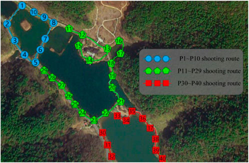
FIGURE 1. Landscape sample photo collection points.
Due to the differences in individual aesthetics, different judges will have different evaluations of the same waterfront greenway photos. In order to ensure the objectivity of the evaluation results, three groups of judges with different professional types were selected in this research study, totaling forty-two people. Among them, the expert group consisted of four experts, mainly engaged in landscape planting research. The gardening group consisted of fourteen university students majoring in gardening-related disciplines, and the other fourteen non-gardening groups consisted of social workers.
We made 80 slides from 80 photos and classified the beauty of the waterfront greenway into seven levels: extremely dislike, very dislike, relatively dislike, general, relatively like, very like, and extremely like, corresponding to scores of 1, 2, 3, 4, 5, 6, and 7, respectively, gathered the judges together, and projected the landscape slides on a large screen using a projector. It is shown three times: the first time at a rate of 2 s to give the judges a comprehensive perception of the entire landscape; the second time at a rate of 4 s to allow the judges to notice the stunning photos; and the third time for the official judging, which is shown at a rate of 10 s. The judges were asked to give a complete review within 10–20 s. After the live scoring by forty-two judges, there were no invalid questionnaires, and forty-two valid questionnaires were received in the end.
Using the standardization method in the SBE method, the differences between the data were removed, thus obtaining a more accurate scenic beauty evaluation value with the following formula:
where
The SBE value is a measure of the aesthetic quality of the landscape and reflects the aesthetic preferences of each reviewer. Therefore, the SBE value needs to be analyzed in depth to explore the aesthetic differences of each group of people and identify the relevant elements that affect the score. If the SBE value is greater than 0, the landscape is of high quality. If the ecological configuration and aesthetic effects are at the desired level, then the quality of the waterfront greenway will be enhanced rather than below zero.
Quantitative analysis is to express some unclear and ambiguous factors with actual concrete data, which can be more convenient and intuitive to see the changing trend of each factor. According to the experimental purpose and the performance characteristics reflected by the landscape photos, the main factors affecting the waterfront greenway landscape are divided into 14 quantitative factors, namely: water ecology, greenway width, greenway material, greenway form, landscape openness, water area ratio, green percentage, vegetation species, vegetation distribution, vegetation color richness, waterfront architecture, sense of spatial extension, waterfront distance, and other supporting scenery. The elements are decomposed into different categories according to the unified standard, and the specific quantification methods are shown in Table 1. Through the image processing software, the proportion of landscape openness, water area ratio, green percentage, and waterfront architecture in the photos can be calculated, comparisons are shown as A and B in Figure 2.
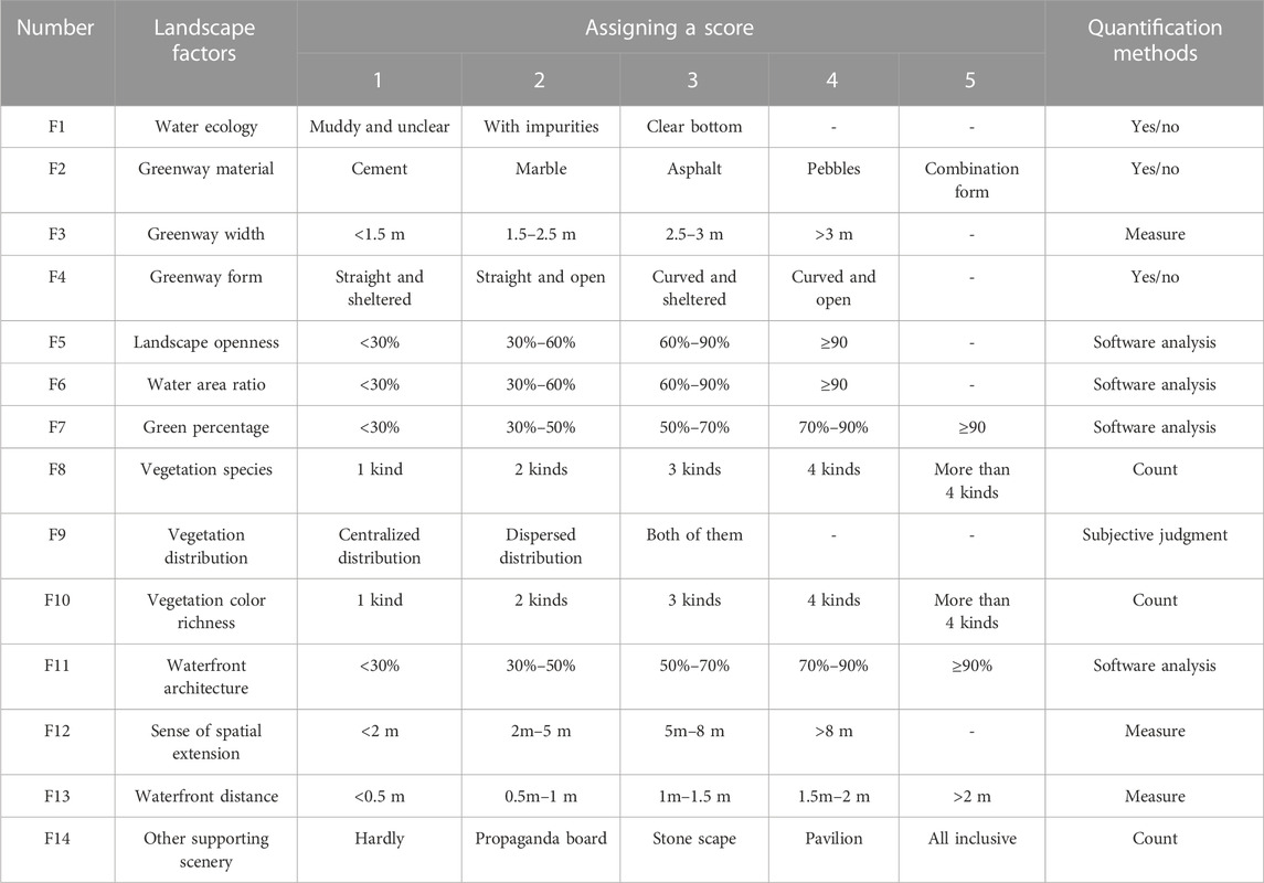
TABLE 1. Quantification and assignment table of landscape factors.
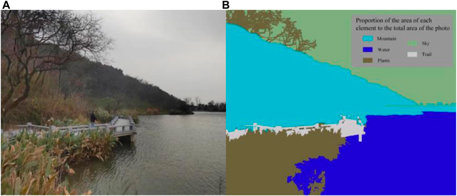
FIGURE 2. Image processing example diagram. (A) Sample, (B) Sample photo analysis images.
The SBE values of each sample were calculated according to the standardized formula as shown in Table 2 and Figure 3. From the figure and table, it can be seen that the number of sample photos with extremely high or low SBE values was low; 75% of the SBE values were distributed between −0.5 and 0.5, and there were more photos with negative SBE values. The sample with the lowest SBE value is photo P54 (see Figure 4), with a score of only −1.40244; the sample with the highest SBE value is photo P30 (see Figure 5), with a score of 1.73117. Further analysis of photos P30 and P54 was conducted. The close-up view of photo P30 shows a trestle bridge, which is neat and clean, with the white body of the bridge reflecting green plants and the reflection in the water being clear and translucent like a mirror. The middle and far views are composed of mountains towering into the clouds, which are lush and green, with different shades of color and order, forming a natural waterfront greenway. The P54 photo shows that the greenway is short and slightly abrupt in color, with an obvious sense of border contrast with the surrounding environment, and the close-up shot is a completely hard landscape, lacking vegetation. Although the water is open, the overall color is single, giving the viewer a negative feeling.
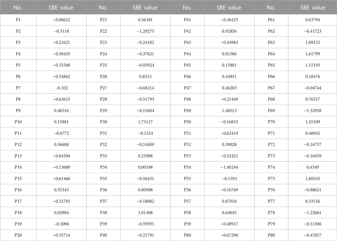
TABLE 2. SBE values of landscape sample photos.
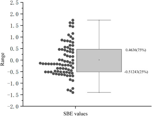
FIGURE 3. Distribution of SBE values.
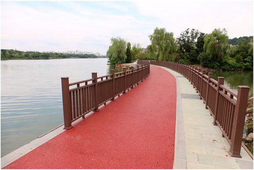
FIGURE 4. No. P54 sample photo.
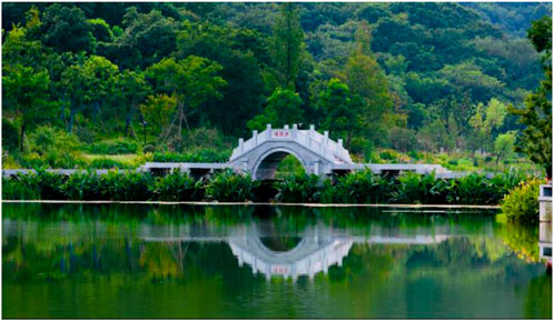
FIGURE 5. No. P30 sample photo.
By observing the sample pictures and their SBE values, it can be found that the high-scoring samples have richer landscape elements and more layered colors, with winding waterfront greenways, a certain amount of artificial or natural supporting scenery around the greenways, wide and layered water views, and strong seasonal changes, showing good natural scenery. The low-scoring samples, on the other hand, showed monotonous views, poor environmental coordination, and poor sightline permeability, and these problems limited the assessment of SBE values. Therefore, in the creation of the waterfront greenway landscape space, appropriate transformation strategies should be adopted according to the local characteristics in order to enhance the landscape’s beauty and make it harmonize with the overall landscape of the real environment.
With the SBE value of the waterfront greenway as the dependent variable and 14 landscape factors as independent variables to establish the model and conduct multiple linear regression analysis, the results are shown in Table 3. Six main factors influencing the SBE value of urban waterfront greenway landscapes were identified, namely,: water ecology, greenway form, landscape openness, water area ratio, vegetation color richness, and other supporting scenery. The six main factors were substituted into the regression equation to establish the landscape evaluation model:
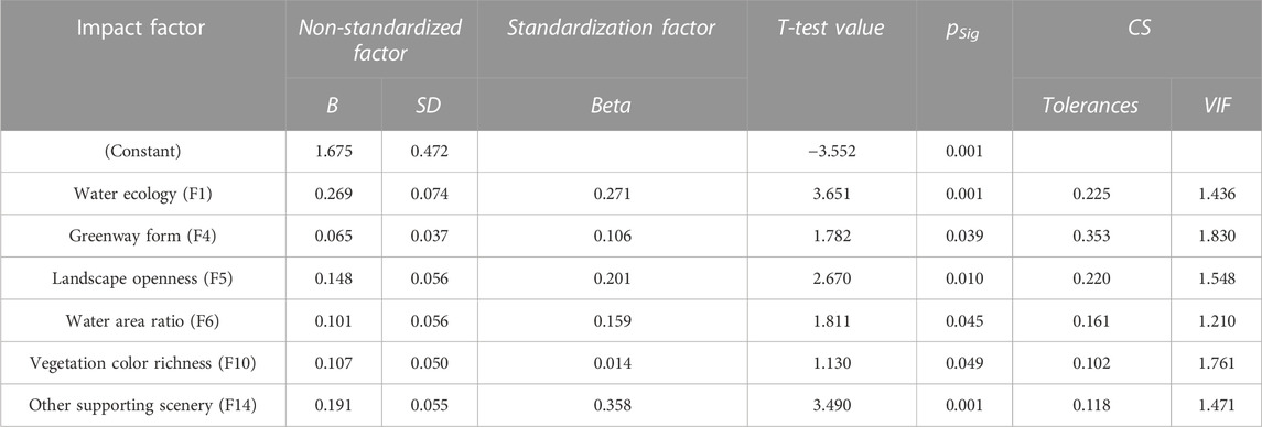
TABLE 3. Coefficient decomposition table of linear regression analysis.
All six factors in the formula are positively correlated with the SBE value. According to the ANOVA table, the model shown in Table 3 passed the F-test at a confidence level of 0.05 (F=12.894,p=0.001e<0.05) and had an R2 value of 0.625, thus allowing a specific analysis of the relationship between the influence of the independent variables on the dependent variable. The fit was more appropriate. Based on this result, ways to enhance the beauty of the waterfront trail were further explored.
In order to evaluate the landscape factors screened by the regression model from more perspectives, eight sample photos with SBE values ≥1 were selected, and experts engaged in landscape architecture, municipal landscape, and water ecology were invited to analyze the degree of influence of the six main factors on the landscape of the waterfront greenway. The results are shown in Figure 6.
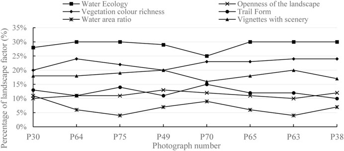
FIGURE 6. Evaluation of six factors in photos with SBE value ≥1.
As can be seen from Figure 6, after the expert evaluation weighting analysis, the priority ranking of the waterfront trail landscape factor is water ecological, landscape openness, other supporting scenery, water area ratio, greenway form, and vegetation color richness. Among them, water ecology is the most important factor; vegetation color richness is also an important factor affecting the waterfront greenway landscape as the natural shape and color give people a rich aesthetic interest; the creation of vignettes with scenery is also an important factor, which can bring people closer to nature, and the space with complete facilities can reflect this more.
Combining SBE values and quantitative evaluation of factors, it can be found that in those landscape nodes with high SBE values, the greenway morphology, water area ratio, and landscape openness are more coordinated, while the water ecology, vegetation color richness, and other supporting scenery of the waterfront greenway are the key factors affecting the waterfront greenway landscape score. Therefore, when constructing the waterfront greenway, focusing on the overall layout, local spatial integrity, and the improvement of individual basic elements can enhance the overall landscape quality.
According to the findings of this paper, combined with literature (Wang, 2021b) and field research, the area of the Tongjian Lake Waterfront Greenway mainly includes the areas of water bodies, heritage areas, trail areas, green areas, building areas, mountain areas, and recreational areas.
In order to present the quantitative factors of the waterfront greenway more accurately, the 2D plan view, isometric map, and 3D modeling were combined to show the real-world factors in a visual way.
The 2D plan view is the landscape plan of the sample photo from the overhead perspective, and the proportional size of the area of each factor of the waterfront greenway to the total area of the photo plan was measured by using the image software. The corresponding landscape patterns as well as colors were filled in, as shown in Figure 7.

FIGURE 7. Plan view of the sample.
The isometric map is closer to human vision compared with the plan view, making the image realistic and three dimensional. First, the isometric map of the landscape area is drawn using the board drawing software, and then, the landscape elements in the map are classified by the image processing software, and the proportion and size of each element in the plane photo are calculated. The weights of vignette matching, greenway morphology, water ecology, vegetation color richness, landscape openness, and water area ratio were analyzed, as shown in Figure 8.
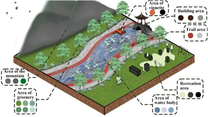
FIGURE 8. Isometric effect of the sample.
Through 3D Max software, the landscape factors in the waterfront greenway photos can be modeled and decomposed into various types of factors such as distant view, medium view, close view, plant angle, and plant color to achieve the purpose of coordinating the water ecology and spatial environment, and according to the characteristics of each factor, the materials are adjusted and finally imported into Lumion rendering to obtain the distribution map of the waterfront greenway landscape factors and realize the 3D spatial expression, as shown in Figure 9.
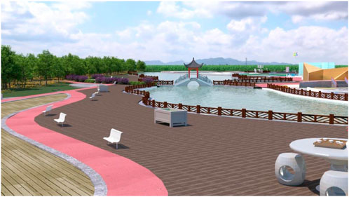
FIGURE 9. 3D spatial effect of the sample.
It is recommended that the openness of the view of the waterfront greenway of Tongjian Lake be increased to provide enough space for visitors to rest within the beautiful scenery and that a viewing platform be set up so visitors can enjoy the scenery. The focus of these changes should be on the continuous flow of the greenway and the guidance of the line of sight, and enhancing the extension of the greenway space through vegetation or other landscape elements. When designing the waterfront greenway, the principle of proximity should be followed to minimize detours so that nearby residents can reach it quickly and easily. The size of the greenway should also be scientific and reasonable, with the flexible treatment of the twists and turns of the channel based on the sparseness of the surrounding air. The spatial distribution should consider the integration of open space and private space as much as possible, so that the surrounding environment, vignettes, grass, trees, and other elements together form a private space, thus increasing the attractiveness of the waterfront greenway.
It is recommended that the greening of the waterfront greenway should be strengthened to cover the entire trail, including the area on both sides of the trail and the surrounding area. Lawns, shrubs and flowers and trees should be reasonably matched with height levels; the water can be planted with some aquatic plants, such as lotus and reeds, to increase the beauty and ecological function of the ecological environment; the surrounding vignette buildings should be covered with vines to increase the greening area and beautify the environment. In this way, the colourful combination of colours can also enhance the visual impact of the landscape. The water surface in the view is static, and the grass and trees are moving. The plants are sparse in the near view but cascading in the far view, which is a collection of dynamic and sparse transformations and brings a rich visual experience to people. The types of vegetation use vines, bamboo, flowers, shrubs, etc., to create a multi-layered and multi-colored flora that has high aesthetic and ecological value. Green plants can not only improve the quality of the landscape but also effectively reduce noise and pollution, having a positive impact on the ecological environment.
The architectural style and environment surrounding Tongjian Lake are mainly Chinese, supplemented by modern minimalist and natural styles. It is suggested that the exterior of the historic district be flexibly combined with flower boxes and planted with evergreen shrubs or flowering plants to enrich the stores along the river. Other neighborhood facades use evergreen shrubs and fast-growing vine plants to enrich the sense of spatial hierarchy and ecological diversity of plant landscapes. At the same time, with the increase of leisure and entertainment places beside Tongjian Lake, the color and location should be integrated with the natural scenery and surrounding buildings, which will make the overall appearance of the entire Tongjian Lake waterfront greenway more harmonious and beautiful.
The scenic area of Tongjian Lake is rich in natural resources and lush vegetation, and the original berm can be seen everywhere. However, the survey shows that as some of the berms have not been designed and transformed, the grass and trees are more disorganized; therefore, it is especially necessary to beautify the berm area to achieve a more perfect landscape effect under the premise of meeting the safety function of flood prevention and flood control. First, the ecological berm should consider the important factor of porosity so that the berm can grow plants and improve the stability of the raised bank structure with the help of plant action. Second, the berms should use flexible materials to adapt to the complex and tortuous lines of the waterfront greenway. The arrangement and spacing of the seats along the lakefront greenway should consider the comfort and privacy of the public; the design of the waterfront platform needs to have enough space for activities; the trestle bridge and others should also have a reasonable form, color adaptation, and solid structure. These leisure facilities can soften the borders of the berm, and while regulating the vegetation structure and beautifying the environment, they can also allow visitors to get close to nature and show a beautiful picture of man and nature living in harmony.
1) This study employs the urban waterfront greenway as its research subject and scores the landscape’s aesthetics according to the SBE method. Six key factors influencing the expression of the scenic beauty degree of the Tongjian Lake waterfront greenway were derived using multiple linear regression analysis and expert evaluation analysis, and based on this, a comparable optimization technique is suggested as a guide for creating future urban waterfront greenways.
2) Regarding the study of the beauty of the urban river and lake landscapes, the method of deriving landscape factors mostly relies on regression models (Sun et al., 2021; Xu, 2023), which are standard but not comprehensive enough. This paper combines the regression model with professional human evaluation to make a comprehensive judgment and comes up with the weight ranking of landscape factors, which fully considers the aesthetic judgment and subjective consciousness feelings. The area is allocated according to the ranking of the landscape factors, and each landscape factor is reflected in the plan according to its area share to obtain a scientific and reasonable area distribution. Furthermore, isometric and three-dimensional maps are depicted, spatial analysis is carried out, and optimization strategies are proposed. Therefore, this paper innovates a new evaluation method for urban river and lake landscapes that is more scientific and intuitive.
3) The findings of this paper discuss the main factors that create a beautiful scenic landscape surrounding urban rivers and lakes, which could guide the landscape design of urban rivers. For rural rivers and large-scale composite rivers, we need to conduct targeted research on the factors influencing scenic landscapes. Additionally, we recommend that the “Beautiful River and Lake” satisfaction survey be updated to include the SEB score to improve the evaluation of the site.
The raw data supporting the conclusion of this article will be made available by the authors, without undue reservation.
XH, XZ, and HF contributed to the conception and design of the study. XH organized the database. XH and XZ performed the statistical analysis. XH and XZ wrote the first draft of the manuscript. HF wrote sections of the manuscript. All authors contributed to the article and approved the submitted version.
This research was funded by the Key R&D Program of Zhejiang (2022C02035) and the Joint Funds of the Zhejiang Provincial Natural Science Foundation of China (LZJWZ22E090004).
The authors are very grateful to the reviewers for their constructive comments and suggestions.
The authors declare that the research was conducted in the absence of any commercial or financial relationships that could be construed as a potential conflict of interest.
All claims expressed in this article are solely those of the authors and do not necessarily represent those of their affiliated organizations, or those of the publisher, the editors, and the reviewers. Any product that may be evaluated in this article, or claim that may be made by its manufacturer, is not guaranteed or endorsed by the publisher.
Cao, B. (2016). Shenyang city river waterfront green space plant landscape evaluation. For. Sci. Technol. Inf. 48 (2), 84–87. doi:10.3969/j.issn.1009-3303.2016.02.032
Fang, P. L., and Liu, X. (2022). Research on landscape construction of urban riverside walkway under micro-intervention design strategy. Chongqing Archit. 21 (S1), 157–160. doi:10.3969/j.issn.1671-9107.2022.S1.157
Huang, Y.-L., Pan, H., Lv, L., et al. (2019). Landscape evaluation of waterfront plants in the campus based on AHP method with guangyin lake of fujian agriculture and forestry university as an example. Southeast Hortic. 7 (04), 49–55.
Li, X. J. (2020). Assessment of the service value of the ecosystem of the Meixiang River as a provincial wetland park. Heilongjiang Hydraulic Sci. Technol. 48 (03), 221–225. doi:10.3969/j.issn.1007-7596.2020.03.063
Li, X., Wang, X., Han, J., Wu, D., Lin, Q., Zhou, J., et al. (2022). Effects of river scale on the aesthetic quality of urban on-water sightseeing. Sustainability 14 (19), 12543. doi:10.3390/su141912543
Liu, L., Liu, Z.-C., Yang, R.-Y., Zhang, R.-F., Li, H., Xu, X.-M., et al. (2016). Quantitative classification and diversity characteristics of plant communities in the river corridor of the dry section of Yongding River (Luliang section). J. Ecol. 40 (24), 9129–9137. doi:10.5846/stxb202003050419
Lu, M.-H., Zhang, T., and Ma, C.-C. (2016). Landscape evaluation of recreational road green space plant communities in Nanjing. Jiangsu Agric. Sci. 44 (12), 239–243. doi:10.15889/j.issn.1002-1302.2016.12.073
Luo, Y., He, J., Long, Y., Xu, L., Zhang, L., Tang, Z., et al. (2023). The relationship between the color landscape characteristics of autumn plant communities and public aesthetics in urban parks in changsha, China. Sustainability 15 (4), 3119. doi:10.3390/su15043119
Ren, X., and Liu, J. P. (2023). Landscape evaluation of plants in nanchong city north lake park based on SBE method. Contemp. Hortic. 46 (7), 50–52. doi:10.3969/j.issn.1006-4958.2023.07.019
Shi, Y., Lv, D., and He, J. (2020). Landscape evaluation of urban parks based on SBE and AHP: A case study of kunming city. IOP Conf. Ser. Earth Environ. Sci. 580 (1), 012016. doi:10.1088/1755-1315/580/1/012016
Sun, D., Li, Q., Gao, W., Huang, G., Tang, N., Lyu, M., et al. (2021). On the relation between visual quality and landscape characteristics: A case study application to the waterfront linear parks in shenyang, China. Environ. Res. Commun. 3 (11), 115013. doi:10.1088/2515-7620/ac34c7
Tan, X., Li, X., and Peng, Y. (2021). Aesthetic evaluation of plant landscape based on principal factor analysis and SBE in wetland park–a case study of Jinlong lake wetland park (China). J. Environ. Eng. Landsc. Manag. 29 (1), 40–47. doi:10.3846/jeelm.2021.14367
Wang, C. (2021). Waterfront park plant configuration analysis--take quanzhou jiangbin north road xinhua dry lock transformation waterfront park as an example. Contemp. Hortic. 44 (24), 48–50. doi:10.3969/j.issn.1006-4958.2021.24.019
Wang, Y.-M., Li, S., and Jiang, J.-Y. (2023). Plantscape assessment of comprehensive parks in wuhan. J. Chin. Urban For. Endocrinol, 1–10. doi:10.12169/zgcsly.2021.04.22.0001
Wei, L. (2017). Spatial interface characteristics of urban waterfront trails. Contemp. Hortic. 344 (20), 114. doi:10.14051/j.cnki.xdyy.2017.20.091
Xu, C. R. (2023). The evaluation and analysis of scenic beauty estimation on the waterfront walkway: A case of the north garden of minjiang park in fuzhou. Urbanism Archit. 20 (2), 189–193. doi:10.19892/j.cnki.csjz.2023.02.51
Xu, H., Ou, D.-Y., Du, C.-Y., Lian, Y.-Q., et al. (2022). Evaluation and comparative analysis of day-night audio-visual land scape of sea plank roa. J Huaqiao Univ. Sci. 43 (06), 736–742. doi:10.11830/ISSN.1000-5013.202111015
Yang, F., Li, C. K., Yang, Y. M., Hang, Q.-T., et al. (2021). Study on the influence of waterfront footpath in Minjiang Park on visitors' physical and mental health. J. Hebei For. Sci. Technol. 230 (3), 28–34. doi:10.16449/j.cnki.issn1002-3356.2021.03.009
Yang, X. (2014). Structural quality in waterfront green space of shaoyang city by scenic beauty evaluation. Asian J. Chem. 26 (17), 5644–5648. doi:10.14233/ajchem.2014.18181
Keywords: urban waterfront greenway, Scenic Beauty Estimation method, landscape expression factor, Tongjian Lake, multi-dimensional presentation
Citation: Hu X, Zou X and Fan H (2023) Analysis of landscape influencing factors of urban waterfront greenways based on the scenic beauty estimation method, taking Tongjian Lake in Hangzhou as an example. Front. Earth Sci. 11:1211775. doi: 10.3389/feart.2023.1211775
Received: 25 April 2023; Accepted: 30 May 2023;
Published: 13 June 2023.
Edited by:
Wei Ge, Zhengzhou University, ChinaReviewed by:
Dongli She, Hohai University, ChinaCopyright © 2023 Hu, Zou and Fan. This is an open-access article distributed under the terms of the Creative Commons Attribution License (CC BY). The use, distribution or reproduction in other forums is permitted, provided the original author(s) and the copyright owner(s) are credited and that the original publication in this journal is cited, in accordance with accepted academic practice. No use, distribution or reproduction is permitted which does not comply with these terms.
*Correspondence: Xun Zou, MTc3NTQ4MDYwMjFAMTYzLmNvbQ==
Disclaimer: All claims expressed in this article are solely those of the authors and do not necessarily represent those of their affiliated organizations, or those of the publisher, the editors and the reviewers. Any product that may be evaluated in this article or claim that may be made by its manufacturer is not guaranteed or endorsed by the publisher.
Research integrity at Frontiers
Learn more about the work of our research integrity team to safeguard the quality of each article we publish.