 Edris Alam1,2*
- 1Department of Geography and Environmental Studies, University of Chittagong, Chittagong, Bangladesh
- 2Faculty of Resilience, Rabdan Academy, Abu Dhabi, United Arab Emirates
Bangladesh is vulnerable to a variety of natural hazards including frequent tropical cyclones, floods and, less commonly, earthquakes and tsunamis. The country has developed an effective response mechanism for frequently experiencing hazards. However, at the same time, the nation has not developed an effective response mechanism for earthquake as a result of limited experiences with this type of hazard in the recent past. This research constructs a new catalogue consisting of 144 earthquakes (between 810BC and 2015) occurring within Bangladesh and the adjacent region. From this new catalogue, the effects of earthquakes are available for 80 events which are used in order to construct the geography of hazard in Bangladesh. The construction of a detailed Modified Mercalli Intensity (MMI) map using the new earthquake data suggests that this will be useful for supporting future risk reduction efforts in Bangladesh. Specifically, the findings support the revision of the current seismic zoning map of Bangladesh to include Chittagong and Dhaka in the high-risk zone for effective earthquake risk reduction. Finally, this research concludes that analyses of long-term data helps to identify new hazard exposure and develop knowledge that is useful to formulate new disaster risk reduction policies and rectify existing know zones in Bangladesh.
1 Introduction
Bangladesh has developed a well-planned disaster responses and mitigation mechanisms for tropical cyclones and floods, however, the mitigation programme for earthquake risk reduction is still in progress. Bangladesh is susceptible to earthquakes due to its location between active seismic zones within and adjacent to the nation. Earthquakes occurring from the adjacent region of Bangladesh has significantly affected this country (Alam and Dominey-Howes, 2014; Alam and Dominey-Howes, 2016). The present seismic zoning map and policies to mitigate the effects of the earthquake hazard in Bangladesh have been developed based on those earthquakes occurring only after 1885, neglecting the potential for large earthquakes from adjacent active faults, particularly the detachment thrust (Choudhury, 2005). Bangladesh is a heavily densely populated country having over 1,000 people per km2 and fragile infrastructure in major city areas. There is no Modified Mercally Intensity map to identify areas of social risk based on long-term hazard data. Therefore, more detailed archival research is required to identify high risk areas based upon available earthquake hazards in Bangladesh and adjacent regions.
In order to construct geographies of the earthquake hazard, it is necessary to understand the sources of hazards that originate in the region of Bangladesh. The Himalayan Mountains are located 200 km from the northern border of Bangladesh. Between the Himalayan Mountains and Bangladesh, the Dauki Fault and the Assam Seismic Fault are located (Figure 1). Additionally, the Bogra Fault System (BGF), the Jamuna Fault (JF), the Madhupur Fault (MF) and the Sylhet Fault (SF) are located within Bangladesh (Figure 1). To the south, the country is bordered by the Bay of Bengal. The Arakan Subduction Zone (ASZ) along the northern end of the Bay of Bengal extends up to the SE Bangladesh. It is a tropical low-lying country having a long funnel shaped coast (Figure 1). Bangladesh has experienced earthquakes those originated from within and adjacent seismic sources in recent and distant past.
FIGURE 1. Location of Bangladesh in relation to regional active fault sources and the primary physiographic units: Tertiary Hills, Pleistocene uplands (the Barind and Madhupur terrace) and Recent sediments. The red solid contour lines show the demarcation of different zones from the mean sea level. The green box shows the location of the Bengal Basin. Key features include ASZ, Arakan Subduction Zone; BD, Bengal Delta; BFS, Bogra Fault System; BR, Brahmaputra River; BT, Barind Tract; BS, Barisal; CC, Chittagong coast; CTFB, Chittagong-Tripura fold belt; DF, Dauki Fault; DK, Dhaka; FT, Faridpur Through; GH, Garo Hills; GR, Ganges River; HF, Haluaghat Fault; HT, Hatiya Through; JF, Jamuna Fault; JH, Jaintia Hills; KH, Khasi Hills; LH, Lalmai Hills; MF, Madhupur Fault; MT, Madhupur Tract; MR, Meghna River; MS, Mymensingh; RH, Rajshahi; SF, Sylhet Fault; SL, Sylhet Hills and SP, Shillong Pleateau (Source: map prepared adapting tectonic elements from Alam et al., 2003; Ali and Choudhury, 2001; Khan, 2012; Mukherjee et al., 2009).
The country is affected by earthquakes originating in India and Myanmar. In order to construct a complete geography of the hazard, it is necessary to consider active seismic sources from the adjacent countries particularly adjoining Bangladesh (Figure 1). The research proposes a new Modified Mercalli Intensity map which has been developed based upon the average effects of 80 earthquakes in Bangladesh occurring between BC810 and 2015 in Bangladesh and adjacent regions.
This paper begins with discussing earthquake hazard zoning and preparation activities. This is followed by a review of data sources used for this research. The methods of the new MMI map construction are detailed and illustrated followed by a presentation of the results. The last sections discuss the significance of the findings and detail the conclusions.
2 Earthquake hazard zoning and preparation activities in Bangladesh
In the late 1970s and early 1980s, was a period were many bridges, buildings and industrial structures constructed throughout Bangladesh. Following this, the assessment of seismic risk in different regions in the country was a great concern of engineers and scientists (Ali and Choudhury, 2001). Research was undertaken to identify areas liable to severe seismic effects in Bangladesh (Kamal, 2008; Sarker et al., 2010). The seismic zoning maps of Bangladesh have been revised continuously with the revised standing orders on disasters which was published in 2010, emphasised the need for mapping areas liable to earthquake damage. To understand the effectiveness of program and policies in relation to earthquake risk reduction, it is necessary to review relevant policies and how they align. Earthquake hazard management includes three key initiatives a) seismic zoning and introduction of building codes, b) seismic and geomagnetic observatories and c) public education and awareness. The first two initiatives are much relevant to the background of this study have been detailed in the following sections.
2.1 Seismic zoning and introduction of building codes
The Geological Survey of India developed the first seismic zoning map for the sub-continent in 1935. North, north-east and south-east regions of Bangladesh had been included in the severe seismic risk zone of the Geological Survey of India map (Figure 2). After Bangladesh became an independent country in 1971, separating from Pakistan the mid 1970s, saw large industrial complexes (e.g., fertilizer factories et al.) built and designed which demanded a sophisticated investigation of seismic risk (Ali and Choudhury, 2001). The 12 May 1977 earthquake (Ms 5.7) along Bangladesh-India border further reaffirmed this requirement to be incorporated in their design. Consequently, in June 1977, the Government of Bangladesh formed a committee of experts to undertake seismic zoning of Bangladesh and formulate policy options. The committee reviewed all the available information, revised seismic risk maps and outlined the newly established building codes for earthquake resistant designs. In 1992, this exercise was repeated, with policies, rules and laws embracing new research and knowledge in earthquake zones and engineer and construction practices. Furthermore, seismic risk maps and building codes were revised to provide improved guidelines for earthquake resistant design. For this mapping exercise, Bangladesh was divided into three zones (Figure 3): Zone 3 (liable to severe damage); Zone 2 (liable to moderate damage); and Zone 1 (liable to slight damage).
FIGURE 2. Indian sub-continent seismic zone map which was prepared by the Geological Survey of India in 1935 (Source: redrawn from Ali and Choudhury, 2001).
FIGURE 3. The current seismic zoning map of Bangladesh indicating probable earthquake zone coefficients. The g value equals maximum ground acceleration that can be expected based upon historic earthquakes over the last 200 years. Zone 1 includes NE of Bangladesh and Sylhet City lies within this zone. Zone 2 includes Dhaka and Chittagong cities. Zone 3 includes SW Bangladesh (Source: redrawn from Ali and Choudhury, 2001).
2.2 Seismic and geomagnetic observatories
The Bangladesh Meteorological Department established an observatory in Chittagong in 1954, with facilities for seismic and geomagnetic observations (Ali and Choudhury, 2001). Until 2007, this was the only seismic observatory in Bangladesh. Although in 1977 the committee of experts recommended the establishment of a minimum of three observatories throughout the country, it has taken over 30 years to establish such observatories which are located in Sylhet, Rangpur and Gazipur (Figure 3) including the modernisation of the Chittagong centre in 2007. Currently in Bangladesh, different institutions such as Dhaka University Earth Observatory (DUEO), Bangladesh University of Engineering and Technology (BUET), Geological Survey of Bangladesh (GSB) and Bangladesh Meteorological Department (BMD) operate seismic monitoring networks separately of each other.
Efforts to identify areas of high seismic risk in Bangladesh have been in progress for some time (Kamal, 2008; Sarker et al., 2010). A number of UN funded projects have worked and been continued to work retrofitting in Dhaka, Sylhet and Mymensingh. There is also still an outstanding need to identify and retrofit fragile buildings in Dhaka and other major cities of Bangladesh (Paul and Bhuiyan, 2010). The pre 2012, policies and practices, which are based on tropical cyclones and floods, may not be adequate to mitigate the consequences of earthquake and tsunamis. However, the drafted disaster management policies of 2012, have initiated several effective measures for earthquake risk reduction. These include:
• enhancing institutional capacity to mitigate earthquake risk, updating building codes, purchasing equipment for the fire service and civil defense department to effectively respond in the post disaster period;
• generating awareness among people about earthquake hazard and risk and arranging training for volunteers;
• developing seismic hazard risk maps for urban areas (for example, Dhaka, Chittagong, Sylhet and Rangpur);
• retrofitting fragile buildings in the above urban areas and developing guidelines for people about the retrofitting;
• developing a program of actions to mitigate consequences of earthquake occurrence in local level urban administration. For example, forming disaster management committee and volunteer teams for awareness generation and operating search, rescue operations with highest participation of local people;
• enhancing earthquake hazard response mechanisms in institutions (Hospital, school and garments);
• conducting research about earthquake hazard and risk; and
• enhancing efficient and professional management team in post disaster rehabilitation.
The review of the work of the Ministry of Disaster Management and Relief, and Disaster Management Department suggests that the Government of Bangladesh is still working towards identifying earthquake prone areas and improving DRR for earthquake related hazards. In order to develop an effective earthquake risk reduction program, it is necessary to review past hazard events and their geographical distribution and impacts in Bangladesh. This research will show how reviewing long-term earthquake data can help accurately identify appropriate seismic risk mapping in Bangladesh.
3 Data sources and methods
The records of Bangladesh earthquakes can be classified according to four types of data sources: geological, archaeological, historical and instrumental data. Each type of record has been collected from existing recognised and published sources. In order to develop a comprehensive earthquake catalogue, data sources were obtained from online global earthquake databases e.g., the National Geophysical Data Center (NGDC, 2012) and Geoscience Australia (GA), (Geoscience Australia, 2011a), International Seismological Centre (ISC, 2023), Incorporated Research Institutions for Seismology (IRIS, 2023), the Novosibirsk Tsunami Laboratory, Russia (NTL), regional catalogue (i.e., Oldham, 1883), annals, chronicles, diaries, letters, travellers, published earthquake catalogues, articles in the peer reviewed literature, books, reports, newspaper articles, local historical books, institutional and administrative memoirs and the historical archive from the India Office Records of the British Library and Royal Society, London. Whilst this research focuses on identifying events that have affected Bangladesh, it has broadened the study to include the area located between Latitude 18.5°S to 28.15°N and Longitude 87° E to 95.5° E to ensure the comprehensive coverage of the study area and adjacent seismically active regions (Figure 1).
3.1 Recording and conversion of earthquake magnitudes
While collecting and collating earthquake magnitudes from secondary sources listed below Table 1, it has been noted several challenges relating to the use of different magnitude scales and the lack of any magnitude scale for some events. On occasion, a source provides Modified Mercalli Intensity (MMI) values for the effects of an earthquake. However, when neither an MMI or magnitude scale was provided, it has been attempted to collect and review the effects of the earthquakes if available. After careful analysis of the effects, this has been converted to the MMI scale and a new MMI value has been provided in Table 1. In this study, when a source material item has been consulted, it is considered to be a secondary source. For example, for the 1764 event, this study has consulted several sources (Anon., 1897; Chandra, 1977; Nandy, 1994), which are considered as secondary sources. Nandy (1994) referred to Campbell (1809) from where information was collected for this particular event. At this stage, this study is not able to consult Campbell (1809) and consider this reference as a primary source for that event. Hence, primary sources are those that this study has not yet consulted for a particular event and secondary sources are those that this has consulted.
TABLE 1. A catalogue of historical and palaeoseismic evidence of earthquake in Bangladesh and adjacent regions between BC810 and AD2015.
For quantification and graphical presentation of the earthquakes, the size of earthquakes should be classified based on their magnitude or intensity scales. For the new earthquake catalogue presented in Table 1, the size of earthquakes was provided in magnitude scales by most source materials. The conversion of earthquake scales from either “magnitude” to “intensity” or vice versa, could distort the actual values of the size of each earthquake. In some cases, intensity values were recorded from secondary sources (Table 1). For example, for the 1676 earthquake (Even #13 in Table 1), an intensity value of 7 was provided by the source document; this intensity value has been converted to 5.7 on the magnitude scale. This conversion of the intensity values of earthquakes to magnitude measured on the Richter scale were performed using the magnitude and intensity relationship (see supplementary material Table 1) provided by the Missouri Department of Environmental Resources (Gere and Shah, 1984). It should be borne in mind that MMI values are often skewed to higher values by locations with higher shaking susceptibility, certain types of soil texture, or locations with buildings that respond to a particular ground shaking frequency in disastrous ways (Ambraseys and Douglas, 2004). As such, converted magnitude from the MMI that has been provided in Table 1 should be treated with caution for the purpose of reuse and further research to more accurately refine these MMIs is required but was beyond the scope of this research.
3.2 Cross checking and validation of data
A total of 99 source documents were consulted to assist with development of the new earthquake catalogue (Table 1). However, inconsistencies in citations, differences in the date of events, differences in magnitude and intensity were identified. Accordingly, it was necessary to employ a rigorous system for cross-checking and validating data. This has been achieved by cross-checking multiple sources and performing a content analysis. This process verifies the date of occurrence of an event, explores inconsistencies in citations and identifies problems relating to magnitudes of earthquakes and evaluates likely effects. The new catalogue Table 1 is the output of this process.
3.3 Data analysis
To construct a geography of earthquake hazards in Bangladesh, the locations of earthquake epicenters are presented in a series of maps to reveal hazards and risks in Bangladesh. A new MMI map is constructed by using the content analysis of 47 source documents for 80 earthquake events occurring in Bangladesh and adjacent regions. Arc GIS was used to construct this map. The presentation and analysis of these earthquakes provides much better earthquake hazard geographies and associated risks in Bangladesh than has previously been available.
4 Results and discussion
In the following sections, it has been introduced key aspects of data, and discussed spatial-temporal distributions of earthquake events in the entire study region and analysed earthquake hazard geographies in Bangladesh.
A total of 144 earthquakes have been identified in the study region between 810BC and AD 2015. Of these events (Table 1) one earthquake (event # 5) was identified from archaeological sources, four earthquakes (event # 1, 2, 4, and 8) were identified from geological sources, the remaining 94 events were identified from historical and instrumental sources. The catalogue comprises the event number, the event date, earthquake locations (including coordinates and geographical location names), earthquake parameters (magnitude, intensity and focal depth), earthquake effects (deaths, injuries, damage in million US $ and house destroyed) information about primary and secondary sources for the event and key comments about earthquakes.
4.1 Earthquakes in and adjacent to Bangladesh
A total of 144 earthquakes are reported to have affected Bangladesh and the adjacent region (Table 1). The locations of these earthquakes are shown in Figures 4, 5. Evidence for three paleoseismic events in 810-400BC, 535-530BC and AD645-980 became available through the geological investigation of the great AD1897 earthquake in Assam (Rajendran et al., 2004). Banerji (1923) and Chaudhury (1964) found the evidence of the AD825-835 earthquake by conducting archaeological investigation in Assam. The geological records of the AD1440-1470 earthquake emerged from the work of Morino et al. (2011) at Mymensingh. Analysis of earthquakes generated in Bangladesh and adjacent areas indicate that the 1762, 1885 and 1897 earthquakes in Bangladesh caused widespread damage. A repeat of similar earthquakes from any of the active seismic sources could cause damage, destruction and death within major population centres in Bangladesh. The effects of recent earthquakes occurring in 1977, 1997, 1999, 2003, and 2007 suggest that lesser magnitude earthquakes could cause significant damage to urban centres that are home to large highly exposed and huge vulnerable communities.
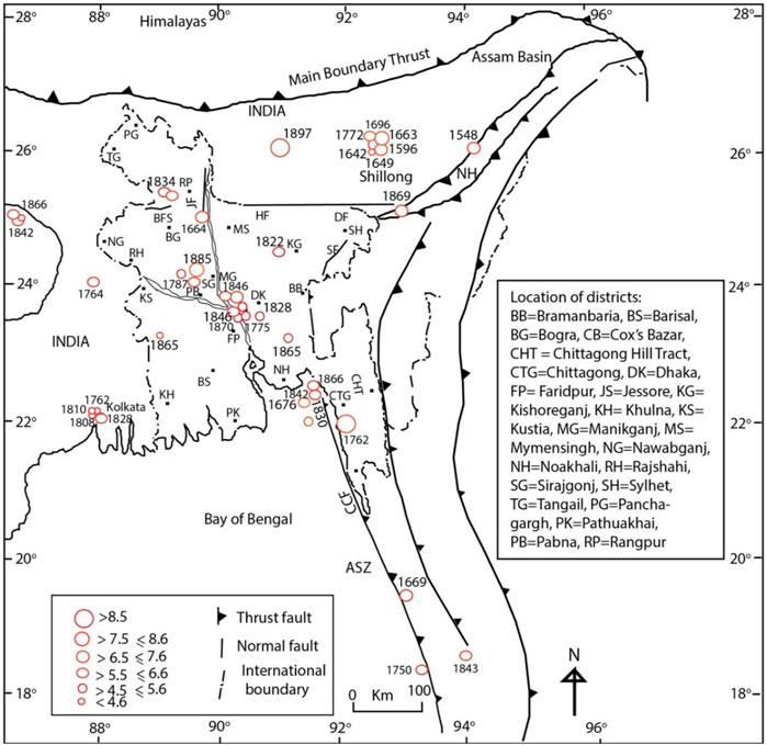
FIGURE 4. Earthquake distribution in Bangladesh and adjacent regions from BC810 to AD1900. The dates of all of the major events are labelled in map. High magnitude earthquakes are located in the active seismic areas in Bangladesh and adjacent India and Myanmar. ASZ, Arakan Subduction Zone; BFS, Bogra Fault System; CCF, Chittagong Cox’s Bazar Fault; DF, Dauki Fault; HF, Haluaghat Fault; JF, Jamuna Fault and SF, Sylhet Fault (Source: base map adapted from Mukherjee et al., 2009).
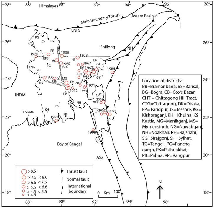
FIGURE 5. Earthquake distribution in Bangladesh and adjacent regions areas from 1900 to 2015. The dates of all of the major events are labelled in map. High magnitude earthquakes are located in the active seismic areas in Bangladesh and adjacent India and Myanmar. ASZ, Arakan Subduction Zone; BFS, Bogra Fault System; CCF, Chittagong Cox’s Bazar Fault; DF, Dauki Fault; HF, Haluaghat Fault; JF, Jamuna Fault and SF, Sylhet Fault (Source: base map adapted from Mukherjee et al., 2009).
4.2 The construction of a new MMI map for Bangladesh
Analysis of the 47 reports (see list of reports below Figure 6) that contain information relating to the effects of 80 earthquakes suggest that severe damage occurred to bamboo houses and masonry buildings in Bangladesh. Disturbances of inland water bodies were also observed in Bangladesh. Co-seismic subsidence, uplift, landslides and compaction were associated with the 1762 earthquake (Alam and Dominey-Howes, 2014). Subsidence and uplift are evidence of neotectonic activity in Bangladesh and adjacent areas (Khan and Chouan, 1996; Hoque and Alam, 1997; Das et al., 2010). The existing flow of the Jamuna River came into its present course only after the 1787 earthquake (Kamaluddin and Rahman, 1985; Bandyopadhyay et al., 2021; Richards et al., 2021). Before the shift of its course, it flowed further east by its original name ‘Old Brahmraputra’ before meeting the Meghna River (Rennell and Banks, 1781; Richards et al., 2021). Additionally, the uplift of the Madhupur surface was possibly associated with the occurrence of the 1762 earthquake (Fergusson, 1863).
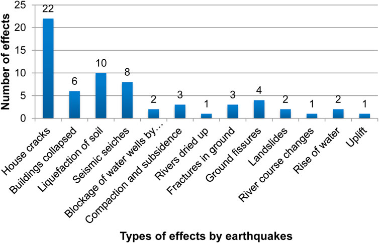
FIGURE 6. The types of impacts caused by earthquakes in Bangladesh (Source: reports numbers at the bottom of Table 1 #s 2, 3, 4, 5, 10, 11, 15, 21, 22, 23, 26, 47, 48, 50, 51, 52, 53, 54, 55, 56, 61, 62, 64, 65, 69, 70, 71, 75, 77, 80, 81, 83, 86, 99, 104, 111, 112, 114, 116, 127, 140, 143, 150, 151, 152, 153, 159, 161, 162, 163, 164, 165, 166, 167, 168).
The effects of earthquakes reports are obtained for 80 events (Table 1 events # 8, 9, 14,16, 17, 21, 23, 37, 38, 39, 42, 43, 44, 55, 64, 69, 74, 76, 79, 84, 85, 95, 97, 98, 107, 108, 161, 119, 153, 165, 168, 170, 178, 190, 191,196, 204, 209, 217, 236, 245, 260, 262, 268, 269, 274, 278, 282, 322, 333, 341, 363, 378, 382, 396, 401, 407, 408, 411, 426, 428, 429, 430, 439, 441, 442, 445, 446, 447, 452, 457, 459, 460, 475, 503, 512, 536, 561, 562). An analysis of 47 reports on 80 earthquakes suggests that in eight (i.e., Bandarban, Kurigram, Kishoreganj, Mymensingh, Sunamganj, Sirajganj, Sylhet, and Tangail) of 64 districts, the effects were over IX on the MMI scale (Figure 7). These districts are located in the northern region of Bangladesh and are close to the Bogra Fault System, Dauki Fault, Haluaghat Fault, Jamuna Fault, Madhupur Fault, Sylhet Fault, and Himalayan seismic sources. The results of the highest risk districts based on the effects of earthquakes measured on the MMI scale coincide with the current seismic zoning map of Bangladesh (Figure 2).
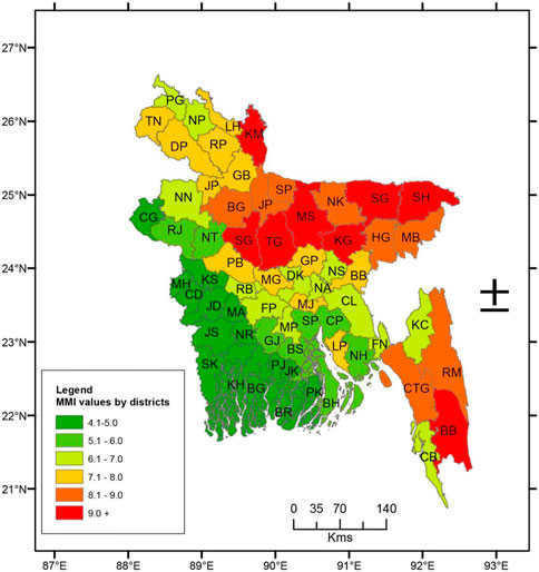
FIGURE 7. An MMI map of the average effects of 80 earthquakes in Bangladesh occurring between BC810 and AD2015 in Bangladesh and adjacent regions. BB, Bandarban; BE, Bagerhat; BG, Bogra; BH, Bhola; BR, Barguna; BS, Barisal; CB, Cox’s Bazar; CD, Chuadanga; CG, ChapaiNawabganj; CL, Comilla; CP, Chandpur; CTG, Chittagong; DK, Dhaka; DP, Dinajpur; FN, Feni; FP, Faridpur; GB, Gaibanda; GJ, Gopalganj; GP, Gazipur, HG, Habiganj; JD, Jhenidah; JP, Jaipurhat; JL, Jamalpur; JS, Jessore; JK, Jhalkati; KC, Khagrachari; KG, Kishoreganj; LP, Lakshmipur; LH, Lalmonirhat; KH, Khulna; KM, Kurigram; KS, Kustia; MA, Magura; MB, Moulvibazar; MG, Munshiganj; MP, Madaripur; MS, Mymensingh; MH, Meherpur; NA, Narayanganj; NH, Noakhali; NK, Netrokona; NN, Noaganj; NT, Nattore; NP, Nilphamari; NR, Narail; NS, Narshingdi; PB, Pabna; PG, Panchgarh; PJ, Pirojpur; PK, Patuakhali; RB, Rajbari; RJ, Rajshahi; RM, Rangamati; RP, Rangpur; SG, Sunamganj; SJ, Sunamganj; SH, Sylhet; SK, Satkhira; SP, Shariatpur; TG, Tangail; TN, Thakurgaon (Source: reports numbers at the bottom of Table 1 #s 2, 3, 4, 5, 10, 11, 15, 20, 21, 22, 24, 32, 33, 34, 35, 36, 37, 40, 41, 42, 43, 44, 46, 47, 48, 49, 51, 52, 53, 54, 56, 68, 71, 72, 79, 84, 85, 86, 87, 91, 93, 94, 95, 96, 97, 98, 99).
The damage intensity caused by earthquakes in Chittagong was rated VIII on the MMI scale. The high MMI value for Chittagong is due to the effects of historical and recent earthquakes that occurred in 1762, 1842, 1851, 1997, 1999, 2003, 2007, and 2008. Chittagong is located along the Arakan Subduction Zone and is close to seismic sources in Myanmar. The damage intensity reached VI on the MMI scale in Dhaka. Although, Dhaka city is comparatively far from seismic sources, the fragile infrastructure and fluvial delta experienced a multitude of different types of effects from earthquakes occurring from adjacent sources. The MMI in the SW districts were 5 or below indicating that they were prone to less damage.
5 Conclusion
This research documented and analysed geological, archaeological and documentary records of earthquakes in Bangladesh to better understand and quantify the hazard–a first step towards improved earthquake risk reduction. The key finding from this research reveals that using long-term hazard data in conjunction with spatial analysis could provide an opportunity to detect areas of high earthquake occurrences. However, records are only available for greater magnitude (7 and above) earthquakes of 1762, 1885, and 1997. No detailed records are available for lesser magnitude earthquakes. This research also supports the revision of current seismic zoning map of Bangladesh to include Chittagong and Dhaka in the high-risk zone for effective earthquake risk reduction. Finally, this research concludes that analyses of long-term data help identify new hazard exposure and develop knowledge that can be useful to formulate new disaster risk reduction policies and rectify existing ones in Bangladesh.
Data availability statement
The raw data supporting the conclusion of this article will be made available by the authors, without undue reservation.
Author contributions
The author confirms being the sole contributor of this work and has approved it for publication.
Conflict of interest
The author declares that the research was conducted in the absence of any commercial or financial relationships that could be construed as a potential conflict of interest.
Publisher’s note
All claims expressed in this article are solely those of the authors and do not necessarily represent those of their affiliated organizations, or those of the publisher, the editors and the reviewers. Any product that may be evaluated in this article, or claim that may be made by its manufacturer, is not guaranteed or endorsed by the publisher.
References
Akhter, S. H. (2010). “Earthquakes of Dhaka,” in Environment of capital Dhaka - plants wildlife gardens parks air water and earthquake. Editors M. A. Islam, S. U. Ahmed, and A. K. M. Rabbani (Ramna, Dhaka, Bangladesh: Asiatic Society of Bangladesh), 401–426.
Alam, E., and Dominey-Howes, D. (2016). A catalogue of earthquakes between 810BC and 2012 for the Bay of Bengal. Nat. Hazards 81 (3), 2031–2102. doi:10.1007/s11069-016-2174-7
Alam, E., and Dominey-Howes, D. (2014). An analysis of the AD1762 earthquake and tsunami in SE Bangladesh. Nat. Hazards 70 (1), 903–933. doi:10.1007/s11069-013-0841-5
Alam, E., Dominey-Howes, D., Goff, J., and Chagué-Goff, C. (2012). Tsunamis of the northeast Indian ocean with a particular focus on the Bay of bengal region—a synthesis and review Indian ocean with a particular focus on the Bay of bengal region– a synthesis and review. Earth-Science Rev. 114 (1–2), 175–193. doi:10.1016/j.earscirev.2012.05.002
Alam, M., Alam, M. M., Curray, J. R., Chowdhury, M. L. R., and Gani, M. R. (2003). An overview of the sedimentary geology of the Bengal Basin in relation to the regional tectonic framework and basin-fill history. Sediment. Geol. 155, 179–208. doi:10.1016/s0037-0738(02)00180-x
Alam, M. J., Bhuiyan, M. A. R., and Islam, M. R. “Seismic structural assessment of damaged Chittagong public library building during 27 July 2003 earthquake,” in Proceedings of the 4th International Conference on Earthquake Engineering, Taipei, Taiwan, October 2006.
Ali, M. H., and Choudhury, J. R. (2001). “Assessment of seismic hazard in Bangladesh,” in Disaster in Bangladesh: Selected readings. Disaster research training and management centre. Editor K. Nizamuddin (Dhaka, Bangladesh: University of Dhaka), 197.
Ambraseys, N., and Douglas, J. (2004). Magnitude calibration of north Indian earthquakes. Geophys. J. Int. 159, 165–206. doi:10.1111/j.1365-246x.2004.02323.x
Ambraseys, N. (2000). Reappraisal of north-Indian earthquakes at the turn of the 20th century. Curr. Sci. 79 (9), 1237–1250.
Anon, (1897b). Cablegraphic news. KalgoorieWestern argus. Parkes, Australia: National Library of Australia, 19.
Anon, (1843a). The asiatic journal and monthly register for British and foreign India, China and australasia. Leadenhall Street, London: Parbury, Allen, and Company, 25.
Anon, (2023). The journal of asiatic society of bengal. Huay Ya, Chonburi Province, Thailand: White Lotus Press, 1053.
Ansary, M. A., Al-Hussaini, T. M., and Sharfuddin, M. (2000). “Damage assessment of july 22, 1999 moheskhali earthquake, Bangladesh,” in Proceedings of the 8th ASCE specialty conference on probabilistic mechanics and structural reliability, Indiana, USA, July 2000, 22–26.
Bandyopadhyay, S., Das, S., and Kar, N. S. (2021). Avulsion of the Brahmaputra in Bangladesh during the 18th–19th century: A review based on cartographic and literary evidence. Geomorphology 384, 107696. doi:10.1016/j.geomorph.2021.107696
Banerji, R. D. (1923). Annual report. Archaeological society of India. Calcutta, India: Central Publication Branch, 80–81.
Bapat, A., Kulkarni, R. C., and Guha, S. K. (1983). Catalogue of earthquake in India and Neighborhood from historical period up to 1979. Roorkee, India: Indian Society of Earthquake Technology, 211.
Benerji, S. K. (1957). Earthquakes in the himalayan region. Jadavpur, Calcutta, India: Indian Association for the Cultivation of Science, 64.
Berninghausen, W. H. (1966). Tsunamis and seismic seiches reported from regions adjacent to the Indian Ocean. Bull. Seismol. Soc. Am. 56, 69–74. doi:10.1785/bssa0560010069
Bilham, R., and England, P. (2001). Plateau ‘pop-up’ in the great 1897 Assam earthquake. Nature 40, 806–809. doi:10.1038/35071057
Bmd, (2011). Earthquake data in and around Bangladesh from 1918 to 2010. Bangladesh meteorological department (BMD), meteorological complex, agargaon, Dhaka, government of the people’s republic of Bangladesh. Web access at http://www.bmd.gov.bd/Earthquake.php.
Campbell, L. D. (1809). A view of the history of hindustan and of the politics, commerce and literature of asia. London, UK: The Asiatic Society.
Chakrabarti, P. G. D., and Gosh, C. (2011). National workshop on earthquake risk management in the north east region Guwahati, Assam, India: National Institute of Disaster Management, 24–25.
Chandra, U. (1977). Earthquakes of Peninsular India-A seismotectonic study. Bull. Seismol. Soc. Am. 67 (5), 387–1413.
Chaudbury, M. H. (1965). “Seismology in India,” in Individual studies by participants to the international Institute of Seismology and earthquake engineering (Tokyo, Japan: International Institute of Seismology and Earthquake Engineering), 14–33.
Choudhury, J. R. (2005). Earthquake-tsunami: The threat looms. Independent weekend. Dhaka, Bangladesh: Free Press Ltd.
Curray, J. R., Emmel, F. J., Moore, D. G., and Raitt, E. W. (1982). “Structure, tectonics and geological history of the north-eastern Indian Ocean,” in The Ocean basin and margin. Editors A. E. M. Nairn, and F. G. Stchli (New York, NY, USA: Plenum Press), 399–450.
Das, J. D., Saraf, A. K., and Shujat, Y. (2010). A remote sensing technique for identifying geometry and geomorphological features of the Indo-Burman frontal fold belt. Int. J. Remote Sens. 31 (61), 4481–4503. doi:10.1080/01431160903154366
Dasgupta, S. “Earthquake geology, geomorphology and hazard scenario in northeast India: An appraisal,” in Proceedings of the National workshop on earthquake mitigation strategy in northeast, Guwahati, Assam, February 2011, 24–29.
Duda, S. J. (1965). Secular seismic energy release in the circum-Pacific belt. Tectonophysics 2 (5), 409–452. doi:10.1016/0040-1951(65)90035-1
Fergusson, J. (1863). On recent changes in the delta of the Ganges. Q. J. Geol. Soc. Lond. 19, 321–354. doi:10.1144/gsl.jgs.1863.019.01-02.35
Geoscience Australia, (2011a). Earthquake@Geoscience Australia. Symonston, Canberra, Australian: Geoscience Australia.
Geoscience Australia, (2011b). Earthquake@Geoscience Australia. Available:http://www.ga.gov.au/earthquakes/searchQuake.do?(Accessed 28th June, 2011).
Gere, J. M., and Shah, H. C. (1984). Terra non firma: Understanding and preparing for earthquakes. New York, NY, USA: W. H. Freeman, 204.
Gulston, E. (1763). An account of an earthquake at chattigaon: Translated from the Persian by mr. Edward gulston, in the service of the honourable east India company, and communicated by him to the reverend mr. Hirst. Philos. Trans. 53, 1683–1775.
Gupta, H., and Gahalaut, V. (2009). Is the northern Bay of bengal tsunamigenic? Bull. Seismol. Soc. Am. 99 (6), 3496–3501. doi:10.1785/0120080379
Gupta, H. K. (1993). Seismic hazard assessment in the Alpine belt from Iran to Burma. Ann. Di Geofis. 36 (3-4), 61–82.
Gutenberg, B., and Richter, C. F. (1965). Seismicity of the earth and associated phenomena. New York, NY, USA: Princeton University Press, Hafner Publishing Company, 310.
Hirst, W. (1763). An account of an earthquake in the east indies, of two eclipses of the sun and moon, observed at Calcutta. Philosophical Trans. 53, 1683–1775.
Hoque, M., and Alam, M. (1997). Subsidence in the lower deltaic areas of Bangladesh. Mar. Geod. 20 (1), 105–120. doi:10.1080/01490419709388098
Hough, S. E., Bilham, R., Ambraseys, N., and Feldl, N. (2005). Revisiting the 1897 shilong and 1905 kangra earthquake in the northern India: Site response, moho reflections and a triggered earthquake. Curr. Sci. 88 (10), 1632–1638.
Hunter, W. W. (1876). “A statistical account of bengal,” in Chittagong hill tracts, and districts of Chittagong, noakhali, tripperah, hill tripperah (London, UK: Trübner and Co.), 444.
Iris, (2023). Seismic event data. Seismological facility for the advancement of geoscience. access on 14 May 2023 at https://ds.iris.edu/ds/nodes/dmc/data/types/events/.
Isc, (2023). ISC bulletin: Event catalogue search. International seismological centre (ISC). accessed on 19 May 2023 at http://www.isc.ac.uk/iscbulletin/search/catalogue/.
Islam, S. I. (2004). Banglapedia: National encyclopedia of Bangladesh. Dhaka, Bangladesh: Asiatic Society of Bangladesh.
Islamabadi, A. (1987). Chattragram smwarani (A memorial in Chittagong) (in Bengali). Chittagong, Bangladesh: Azadi Printers Limited, 159.
Iyengar, R. N., Sharma, D., and Siddiqi, J. M. (1999). Earthquake history of India in medieval times. Indian J. Hist. Sci. 34 (3), 181–237.
Jaiswal, R., Rastogi, B. K., and Murty, T. S. (2008). Tsunamigenic sources in the Indian ocean. Sci. Tsunami Hazards 27 (2), 32–53.
Kamal, A. S. M. M. (2008). Seismic hazard assessment for Chittagong city corporation area, Bangladesh. Int. Geol. Congr. Oslo, 6–14. doi:10.4172/2167-0587.1000154
Kamaluddin, A. F. M., and Rahman, K. M. (1985). “The pattern of the structures of rural employment in Bangladesh – a study of the thanas in Sirajganj,” in Geographical essays (New Delhi, India: Inter India Publications).
Khan, A. A., and Chouan, R. K. S. (1996). The crustal dynamics and the tectonic trends in the Bengal Basin. J. Geodyn. 22 (3-4), 267–286. doi:10.1016/0264-3707(96)00022-1
Khan, A. A. (2004). Earthquake vulnerability and hazard assessment in the active collision margin of Bangladesh with special reference to Dhaka, Chittagong, and Sylhet triangular region. Bangladesh: Research Report Ministry of Science and Information and Communication Technology Government of Bangladesh, 96.
Khan, A. A. (2010). Earthquake, tsunami and geology of Bangladesh. Dhaka, Bangladesh: University Grant Commission of Bangladesh, 331.
Khan, A. A., and Hossain, M. M. (2005). Recurrence of 1885 bengal earthquake and hazard vulnerability status of Dhaka metropoliton city, Bangladesh. Orient. Geogr. 49 (2), 205–216.
Khan, A. A. (2012). Seismogenic sources in the Bay of Bengal vis-à-vis potential for tsunami generation and its impact in the northern Bay of Bengal coast. Nat. Hazards 61, 1127–1141. doi:10.1007/s11069-011-9970-x
Mandal, P., Rastogi, B. K., and Gupta, H. K. (2000). Recent Indian earthquakes. Curr. Sci. 79 (9), 368–379.
Martin, S., and Szeliga, W. (2010). A catalog of felt intensity data for 570 earthquakes in India from 1636 to 2009. Bull. Seismol. Soc. Am. 100 (2), 562–569. doi:10.1785/0120080328
Middlemiss, C. S. (1885). Reports on the bengal earthquake of july 14th, 1885. Rec. Geol. Surv. India 18, 200–221.
Milne, J. “Catalogue of destructive earthquakes,” in Proceedings of the 81st meeting of the British Association for the Advancement of Science, Portsmouth, London, 1911, 649–740.
Mithal, R. S., and Srivastava, L. S. (1962). “Seismicity of the area around Baraundi, Bihar,” in Proc. Symp. Earthquake eng (Roorkee, India: University of Roorkee), 527–538.
Morino, M., Kamal, A. S. M. M., Muslim, D., Ali, R. M. E., Kamal, M. A., Rahman, M. Z., et al. (2011). Seismic event of the Dauki Fault in 16th century confirmed by trench investigation at gabrakhari village, Haluaghat, Mymensingh, Bangladesh. J. Asian Earth Sci. 42, 492–498. doi:10.1016/j.jseaes.2011.05.002
Mukherjee, M., Fryar, A. E., and Thomas, W. A. (2009). Geologic, geomorphic and hydrologic framework and evolution of the Bengal basin, India and Bangladesh. J. Asian Earth Sci. 34, 227–244. doi:10.1016/j.jseaes.2008.05.011
Murty, T. S., and Rafiq, R. (1991). A tentative list of tsunamis in the marginal seas of the north Indian Ocean. Nat. Hazards 4 (1), 81–83. doi:10.1007/bf00126560
Nandy, D. R. (1994). Earthquake hazard potential of central and south Bengal Basin. Indian J. Earth Sci. 21 (2), 59–64.
Neic, (2023). Earthquake events. NOAA national centres for environmental information (NEIC). access on 21 May 2023 at https://www.ngdc.noaa.gov/hazel/view/hazards/earthquake/search.
Ngdc, (2012). Global significant earthquake database from 2000 B.C. to present. Available: http://www.ngdc.noaa.gov/hazard/earthqk.shtml (Accessed June 1, 2012).
Nutalaya, S., Sodsri, S., and Arnold, E. P. (1985). Series on Seismology. Thailand: Southeast Asia Association of Seismology and Earthquake Engineering and U. S. Geological Survey.
Oldham, R. D. (1883). A catalogue of Indian earthquakes from the earliest time to the end of A.D 1869. Memoirs Geol. Surv. India 19 (3), 163–215.
Paul, B. K., and Bhuiyan, R. H. (2010). Urban earthquake hazard: Perceived seismic risk and preparedness in Dhaka city, Bangladesh. Disasters 34 (2), 337–359. doi:10.1111/j.1467-7717.2009.01132.x
Pervez, I. A., and Ram, A. (1997). Probabilistic assessment of earthquake hazards in the North-East Indian peninsula and Hindukush regions. Pure Appl. Geophys. 149 (4), 731–746. doi:10.1007/s000240050049
Rajendran, C. P., Rajendran, K., Duarah, B. P., Baruah, S., and Earnest, A. (2004). Interpreting the style of faulting and paleoseismicity associated with the 1897 Shillong, northeast India, earthquake: Implications for regional tectonism. Tectonics 23 (TC4009), 419–429. doi:10.1029/2003tc001605
Rastogi, B. K., and Jaiswal, R. K. (2006). A catalogue of tsunamis in the Indian Ocean. Sci. Tsunami Hazards 25 (3), 128–143.
Rennell, J., and Banks, J. (1781). An account of the Ganges and burrampooter rivers. Philosophical Trans. R. Soc. Lond. 71, 87–114.
Richards, K., Brammer, H., and Saunders, L. P. (2021). The historical avulsion of the Tista River, and its relationship to the Brahmaputra: Map and archive evidence from 1750 to 1835. Geogr. J. 187 (3), 253–268. doi:10.1111/geoj.12391
Rizvi, S. N. H. (1970). Bangladesh district gazetteers, Sylhet. Dhaka, Bangladesh: Government of the People’s Republic of Bangladesh.
RizviS.N.H., (1969). East Pakistan district gazetteers: Dacca. Dhaka, Bangladesh: East Pakistan Government Press, 353.
Sarker, J. K., Ansary, M. A., Rahman, M. S., and Safiullah, A. M. M. (2010). Seismic hazard assessment for Mymensingh, Bangladesh. Environ. Earth Sci. 60 (3), 643–653. doi:10.1007/s12665-009-0204-4
Sharfuddin, M. (2010). “Earthquake hazard analysis for Bangladesh,”. MSc Thesis (Dhaka, Bangladesh: Department of Civil Engineering, Bangladesh University of Engineering and Technology).
Singh, K. (1966). Earthquakes in India and neighbourhood. Indian J. Meteorology Geophys. 4 (17), 521–528. doi:10.54302/mausam.v17i4.5753
Singh, V. P., and Shankar, D. (1992). On the seismicity and tectonic activity of the Bengal Basin. Mausam 43, 371–378. doi:10.54302/mausam.v43i4.3504
Steckler, M. S., Akhter, S. H., and Seeber, L. (2008). Collision of the ganges–brahmaputra delta with the Burma arc: Implications for earthquake hazard. Earth Planet. Sci. Lett. 273, 367–378. doi:10.1016/j.epsl.2008.07.009
Tillotson, E. (1951). The great Assam earthquake of august 15, 1950. Nature 167, 128–130. doi:10.1038/167128a0
United Nations Office for the Coordination of Humanitarian Affairs, (1993). India earthquake september 1993, UN DHA situation reports. New York, United States: United Nations Office for the Coordination of Humanitarian Affairs, 1–8.
Usgs, (2023). Earthquake hazard program. United states geological Survey (USGS). accessed on 17 May 2023 at https://earthquake.usgs.gov/data/comcat/.
Verelst, (1763). An account of the earthquakes that have been felt in the province of islamabad, with the damages attending them, from 2nd to the 19th of april, 1762: Translated from the Persian, and communicated to henry vansittart, esq; president and governor of fort william in bengal, by mr. Verelst, chief of the hon. East India company’s Affairs at islamabad. Philos. Trans. 53, 1683–1775.
Webster, J. E. (1911). Eastern bengal and Assam district gazetteer: Noakhali. Allahabad, India: The Pioneer Press, 107.
Keywords: earthquake, hazard, intensity, risk, data, Bangladesh
Citation: Alam E (2023) A Modified Mercalli Intensity map of Bangladesh: a proposal for zoning of earthquake hazard. Front. Earth Sci. 11:1187176. doi: 10.3389/feart.2023.1187176
Received: 15 March 2023; Accepted: 03 July 2023;
Published: 27 July 2023.
Edited by:
Sandipan Das, Symbiosis International University, IndiaReviewed by:
Andrea Tertulliani, National Institute of Geophysics and Volcanology (INGV), ItalyVoltaire Alvarado Peterson, University of Concepcion, Chile
Copyright © 2023 Alam. This is an open-access article distributed under the terms of the Creative Commons Attribution License (CC BY). The use, distribution or reproduction in other forums is permitted, provided the original author(s) and the copyright owner(s) are credited and that the original publication in this journal is cited, in accordance with accepted academic practice. No use, distribution or reproduction is permitted which does not comply with these terms.
*Correspondence: Edris Alam, ZWFsYW1AcmEuYWMuYWU=