 A. Rex Bunn
- Independent Researcher, Newcastle, NSW, Australia
Among the Seven Wonders of the Ancient World, only the Great Pyramid of Giza survives. Yet there is another, older than the seven, that was found and then lost again in the 19th century and once more located by the research herein: the White Terraces, named Te Tarata by indigenous peoples, of the Taupō Volcanic Zone in New Zealand. The greatest geoscience and tourist attractions in the southern hemisphere were the siliceous Pink and White Terraces. European, American, and British tourists bypassed the calcareous terraces at Saturnia, Yellowstone, and Pamukkale for the long sea voyage down to New Zealand. The 1886 Mount Tarawera eruption buried the siliceous terraces, decimating their indigenous owners and their tourism. An eruption crater lake now occupies much of the Rotomahana Basin in the Taupō Volcanic Zone, leading to assumptions that the Terraces were lost. However, no evidence was produced. The indigenous Māori owners did not believe they were lost. Controversy ensued. The resolution of this controversy is of economic and cultural importance as well as scientific interest. In 2011, a joint New Zealand-American project claimed to have found the Pink and White Terraces underwater in crater lake but produced no sinter samples. Recently, their claims were refuted. In Europe, terrestrial survey documents were unearthed, including compass bearings to the terraces by the German geologist Ferdinand Hochstetter. His survey records were digitally repatriated, and the reconstruction of his 1859 survey showed that the terrace springs lay outside the eruption crater. This renewed research in the Rotomahana Basin which has resolved the controversy. By studying topography and with the aid of Māori navigation knowledge, the geographic coordinates of the White Terraces have been triangulated and lie on land, on the shoreline outside the 1886 crater. Surprisingly, this evidence demonstrates that the White Terraces could have been located after the 1886 eruption by observation of the Rotomahana Basin with mapping available since 1864. Exploration and excavation of the Terraces are now possible. Even if degraded by the 1886 eruption, the White Terraces may earn a World Heritage listing and a second life in global tourism.
1 Introduction
Among the Seven Wonders of the Ancient World, only the Great Pyramid of Giza survives. Older than these seven is another ancient lost wonder of the new world in the southern hemisphere—the siliceous sinter White Terraces of the Taupō Volcanic Zone in New Zealand (Keam, 2016). The age of the White Terraces was first estimated by geophysicist Ron Keam (1932–2019) in 2016 (Keam, 2016). Following his method with the first evidence-based Lake Rotomahana altimetry in 2022 provides a White Terrace date of ∼5,000 BCE, making the White Terraces older than the Great Pyramid (Bunn, 2022a).
The White Terraces were the largest of three siliceous terraces in the Rotomahana Basin. With the Pink and Black Terraces, they formed the principal geothermal site of the Taupō Volcanic Zone. The White Terraces were first visited by Māori immigrants in the 13th century, while the first European visitors arrived in the mid-19th century. The Terraces became an international tourism attraction later that century and were presumed lost during the 1886 Mount Tarawera eruption (Smith, 1887). As they were not officially surveyed, their locations were uncertain. Thus, no evidence could be produced of their location or loss. Controversy over their survival continued until the 1940s. Indigenous Māori experts, e.g., Alfred Warbrick (1860–1940) believed that the Terraces had survived buried in ash (Warbrick, 1934; Warbrick, 1936). A 1954 eyewitness report gives possibly the finest firsthand account of the Terraces (Bennett, 1954). Claims have been made by generations of geoscience workers since, but none has produced a Terrace sample (De Ronde et al., 2016; GNS Science, 2019). The terraces passed into legend until 2011 with reports of finding in situ terraces by a joint New Zealand-American underwater project (de Ronde, 2011). The controversy resumed with an immediate challenge (Keir, 2012). Recently, the joint New Zealand-American project claims, based on photo interpretation and an unfinished map, were refuted (Bunn, 2020a; Bunn, 2020b; Bunn, 2021).
Figure 1 records the 1886 Mount Tarawera eruption rift passing southwest through the Tarawera massif, beneath Wahanga, Ruawahia, and the Tarawera peaks and the new crater Lake Rotomahana and on toward Waimangu. The inset right-side North Island map positions the Rotomahana Basin (inset yellow rectangle) inside the Taupō Volcanic Zone (inset white polygon). The maps in Figures 5, 9, 10, and 16 are also inset in Figure 1 as black rectangles with the matching figure number in the right lower corner for reference.
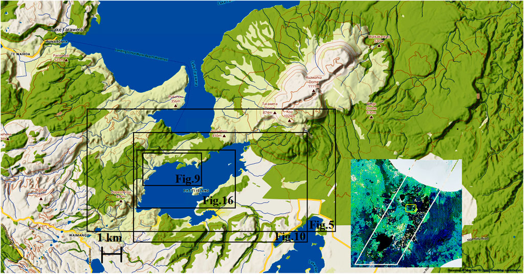
FIGURE 1. In the Rotomahana Basin within the Taupō Volcanic Zone, the rift from the 1886 Mount Tarawera eruption passes southwest beneath the Wahanga, Ruawahia, and Tarawera peaks and the new crater Lake Rotomahana before moving toward Waimangu. The inset map of the right side of the North Island positions the Rotomahana Basin (inset yellow rectangle) inside the Taupō Volcanic Zone (inset white polygon). The maps in Figures 5, 9, 10, and 16 are also inset in Figure 1 as black rectangles with the matching figure numbers in the right lower corners for reference (River Pilot).
In Europe in 2010, terrestrial survey documents were unearthed including compass bearings to the terraces by German geologist Ferdinand Hochstetter (1829–1884). His survey records were digitally repatriated and his 1859 survey was reconstructed, showing that the terrace springs lay outside the eruption crater and may, therefore, have survived in some form (Bunn and Nolden, 2016; Bunn and Nolden, 2018). The research question arose of how to validate these findings from survey resection and triangulate the survey with other lines of evidence. This led to a new examination of the 1886 Rotomahana Basin eruption crater, which now holds the enlarged Lake Rotomahana (incorporating the pre-eruption Lake Rotomakariri). By studying the pre- and post-eruption basin topography and with the aid of Mātauranga Māori knowledge, the geographic coordinates for the White Terrace can be triangulated. Surprisingly, the research led to the realization that geospatial evidence existed immediately after the June 1886 eruptions to provide a basic navigational route to the White Terrace. The evidence has never been recognized. The present work traces the chain of navigational waypoints (geographic reference points) leading to the White Terraces’ location. It triangulates this with terrestrial surveys and Māori mental-mapping records to complement the findings. The White Terraces’ (Te Tarata) latitude and longitude coordinates are now validated. However, these coordinates are of limited value given that the sites are overlain with ejecta from 1886 and chronic erosion. Altimetry is necessary to calculate how deeply the terraces are buried. These data were unclear as altimetry in the 19th century was primitive. For this reason, the first evidence-based altimetry for old Lake Rotomahana and the Terraces was recently published (Bunn, 2022a).
Subsequently, the author realized that much of the previous research was unnecessary, i.e., to navigate to the basic location of the White Terrace today or at any time since the 1886 eruption. All that was ever required was one large-scale map published in 1864, with an observer beside the Rotomahana crater or the new crater lake (Figure 2). If not on site, a second map published months after the 1886 eruption (Figure 3) could be used. These maps were taught in New Zealand schools, and no qualifications are needed to appraise the topography and find the basic White Terraces location. Both maps are available online (Hochstetter and Petermann, 1864a). The research hypothesis to be tested is that given the terrace spring coordinates have been resected by terrestrial surveys, these geographic coordinates can be verified by triangulation with topographic and Mātauranga Māori methods.
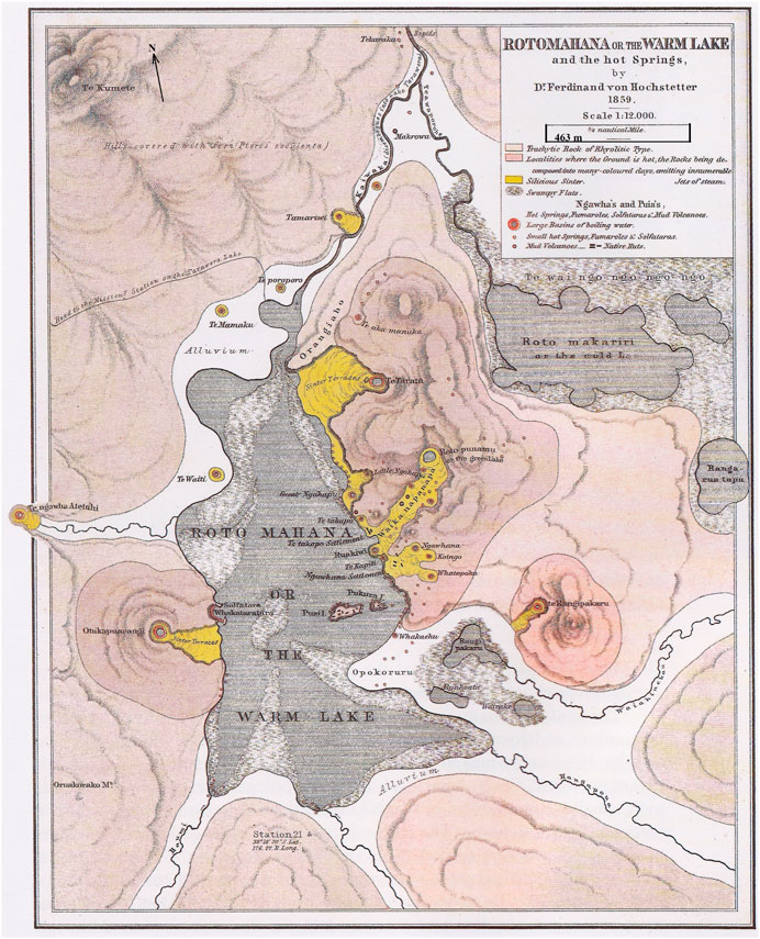
FIGURE 2. Map of Lake Rotomahana from the English edition of Hochstetter & Petermann’s Geological and Topographical Atlas of New Zealand, showing streams entering and leaving the lakes. Note the orientation from the north arrow (Hochstetter and Petermann, 1864a).
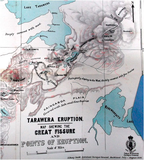
FIGURE 3. Rotomahana Basin in July−August 1886 (Smith, 1887).
2 Methods and data
The research model incorporates the Rotomahana Basin crater topography and cartography; lakes; streams; Mātauranga Māori records; and the Pink, Black, and White Terraces springs. Given the importance of altimetry, a three-dimensional approach is taken with proximal basin features, i.e., tracing the latitude, longitude, and altitude of key features over time before, during, and after the 1886 eruption.
We first examine the Rotomahana Basin crater topography, followed by the watercourses and basin lakes, Māori navigation, and finally the three terrace springs (Pink, Black, and White Terraces).
2.1 Rotomahana Basin topography and cartography
As shown in Figure 2, the pre-1886 Rotomahana Basin was m-shaped: characterized by a central ridge known as the Steaming Ranges (lying north-south with ∼125 geothermal features) and named by Daniel Mundy (1826–1881), (Mundy, 1875). The Māori name is unrecorded. Hochstetter first described the Steaming Ranges (also later called Pinnacle Ridge) containing the White Terraces as: “a hill—rising about 200 feet about the level of the lake, overgrown with fern and Manuka—which steams on more than a hundred other places” (Hochstetter, 1867). The ridge lay between longitude 176.432° E–176.44° E and was ∼1.4 km long, ∼60 m high, and ∼600 m wide. Its major axis lay north-south. The Waikanapanapa Valley divided it into north and south sections. The White Terrace spring and apron lay over the northern hillside. Thousands of tourists saw it there. Lakes were located on either side of the ridge: Lake Rotomahana on the west and Lake Rotomakariri on the east. To the west of Rotomahana lay a small flat flanked by the Kumete Ridge. To the east of Rotomakariri lay a small flat flanked by Mount Tarawera and the Tarawera massif, which overlooked the basin. From Kumete Ridge to Tarawera peak was 7 km. The White Terrace spring lay on the northwest tip of the Steaming Ranges. The Pink Terrace lay on the western shore of Lake Rotomahana with the Black Terrace between it and Kumete Ridge (Figures 2, 3).
The compact basin was packed with tourist features and lost nearly all its proximal landmarks in the eruption. Those that remained went unrecognized after 1886. Lacking Hochstetter’s 1859 survey, other present-day workers resorted to pre-1886 photographs and artwork, drawing sightlines on distal landmarks to estimate the proximal Terrace locations. The innate Type I (false-positive) errors in such photo-interpretation over the crowded compact basin prevented validation in the altered landscape (Bunn, 2019a; Bunn, 2020b; Bunn, 2021). Even with the only terrestrial survey data, it has taken six survey iterations over 7 years to establish the Terrace coordinates beyond a reasonable doubt. The present work triangulates them with topographic and Mātauranga Māori research.
Note: The nomenclature of the White Terraces, usually translated as Tattooed Rock (Te Tarata), is uncertain as there are few examples of tattooed rocks in New Zealand. The name may instead be a botanical term derived from the undulate leaves of the lemonwood tree (Pittosporum eugenioides or Pittosporum crassifolium) (Hochstetter, 1867). This is currently considered the more likely explanation given the recently translated Māori botanical name of the largest boiling spring in the series abutting Te Tarata, Te Aka Mānuka—The Mānuka Vine (personal communication: Rangitihi Pene, Chairman Hinemihi Marae, 24 September 2022). Mānuka is a flowering shrub of the myrtle family. The New Zealand species Leptospermum scoparium is valued for the honey collected by bees from its flower nectar. The dark honey has reported antibacterial and antiseptic properties and edible grades sell for $A200/kg, with skincare grades costing more. The adjacent Tarata and Mānuka geysers were probably named at the same time in the 13th century. In the absence of Māori records, the botanical origin for Te Tarata now appears likely.
Without Hochstetter’s survey, there was sufficient cartographic, topographic and historical record evidence as the sun rose that 10 June 1886; for the White Terraces location to be found in the altered landscape. Any competent observer with Hochstetter’s 1864 map could locate the White Terraces. After 1886, any desk researcher with the maps shown in Figures 2, 3 could solve the riddle of the missing Pink and White Terraces. None did.
It is trenchant criticism of the three government teams in 1886–1887 that they failed to recognize the evidence while including it in their reports. They were looking for a lake and disregarded evidence in the new landscape. The initial Tarawera massif eruption, i.e., from Wahanga peak, was witnessed on the night by Alfred Warbrick, with the rift starting on this eastern peak and proceeding southwest along the Ruawahia and Tarawera peaks of the Tarawera massif before creating the chasm in the side of Tarawera and then continuing under lakes Rotomakariri and Rotomahana and into the Okaro area along the Haumi Stream valley. This valley later became the Waimangu Valley. It followed an azimuth of ∼57°. The rift was in a state of chaos and was later compared to a zipper opening. While zippers were not invented in 1886, commonsense suggests that 1886 observers wishing to grasp the topography would look on either side of the rift for features forced apart by the rift to orient themselves in the landscape and answer the question that held the nation: did the Pink and White Terraces survive?
The Arawa Māori tribal elders, with different mapping and navigation methods, all observed that the Pink and White Terraces lay buried in mud (Warbrick, 1934; Warbrick, 1936). The government surveyors and geoscientists from 1886 forward either did not ask or did not listen.
Signposts lay in the Rotomahana crater. The first of these was the Steaming Ranges. This hill was traversed by every tourist between c. 1848 and 1886. Stephenson Percy Smith (1840–1922), the Assistant Surveyor General, refers to this hill in his eruption field report: “immediately to the north of the central lake there are some rugged pinnacles of black rock, rising to the height of the crater rim. These have a special interest as marking the site of some of the hills which formerly stood close to the White Terraces …” (Smith, 1887). Our reconstruction of Hochstetter’s survey bearings and our georeferencing of his cartography confirm Assistant Surveyor General Smith’s (1887) report that this northern hill was the surviving northern stump of the Steaming Ranges (Smith, 1887).
However, two sets of pinnacles were present, lying north and south of the rift stretching down from Mount Tarawera. This is shown in Smith’s (1886) manuscript and published maps, in period photography by George Valentine (1852–1890), and in paintings by Charles Blomfield (1848–1926), which provide a better perspective from the crater floor versus the photographers restricted to the northwest crater rim. The highest section of the northern pinnacles (The Pinnacle) is surrounded by steam and ejecta, joining it to the land on the north crater rim in Figures 3, 4.
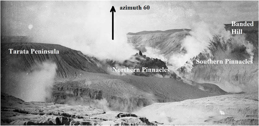
FIGURE 4. Tarata Peninsula abutting the northern pinnacles and Banded Hill abutting the southern pinnacles (and extending out of the shot). Note the azimuth 60° arrow to orient the image (Burton, MA_1323002 Te Papa).
Smith’s opinion that the northern pinnacles were located on the Steaming Ranges is confirmed by our surveying, which in turn supports Ron Keam’s observation: “…almost at its northern extremity, hosted Te Tarata …” (Keam, 2016).
2.2 Rotomahana Basin watercourses
Figure 2 shows five pre-eruption streams flowing into old Lake Rotomahana and one exiting the lake. On today’s River Pilot in Figures 5, 13 streams flow into the new Lake Rotomahana, and none exit. The increased stream number is due to the 1886 crater enlarging beyond the old lake shores save for a section between the Pink and White Terraces. The new lake is about ten times the surface area of the old. The 1886 eruption also altered the landscape with ejecta ≤30–50 m in depth infilling watercourses around the old lake. The new lake’s elevation is 35–37 m above the old. The pre-eruption streams have never been examined with those in Figure 5. This study reports the evidence from these watercourses.
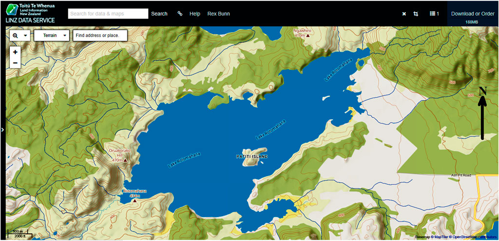
FIGURE 5. Rotomahana Basin topography detailing the post-eruption streams (New Zealand River Pilot). Refer to Figure 1 for location details.
2.3 Rotomahana Basin lakes
While Lake Rotomahana is a focus of this research, other significant bodies of water were present within the Rotomahana Basin (Figure 2), including Lake Rotomakariri, an unnamed adjacent lake referenced as Lake Rotomakariri 2, Rangarua Tapu, Rangipakaru, Ruahoata, Wairake, and Green Lake. These are important when tracing watercourses and making volumetric estimations of surface water in the Basin on 9 June 1886, i.e., the eruption eve. Lake Rangipakaru provides an index of the changes in depth of the shallow Lake Rotomahana, as it merged with Lake Rotomahana when the water level rose. The nearby Lake Tarawera is considered in this study only as it assists the evidence-based altimetry for Lake Rotomahana.
Given the increase in altitude, area, and depth of today’s Rotomahana crater lake, I refer to old Lake Rotomahana for the lake up to 9 June 1886 and new Lake Rotomahana for the lake after 10 June 1886. The Rotomahana crater required over 1 decade to fill with meteoric and catchment water.
2.4 Mātauranga Māori
Mātauranga Māori refers to the traditional knowledge of the indigenous Māori people of New Zealand. This population had been isolated in New Zealand since the 13th century and had no written language. The first Maori–English dictionary was completed in 1844, 42 years before the Tarawera eruption. Their traditional knowledge was recorded and transmitted orally. It is interdisciplinary and is now regarded alongside Western scientific knowledge. The Māori immigrants were Polynesian seafarers who navigated to New Zealand and developed a comprehensive mental-mapping record of their new country (Barton, 1998). This included giving place names (toponyms) to every stream, hill, lake, island, and feature to assist their land navigation. This was evident to the early Western visitors to Lake Rotomahana and can be seen in Figure 2 where the Rotomahana Basin is mapped with associative names, similar to mnemonics.
One toponym concerns the White Terrace and Te Aka Mānuka (The Mānuka Vine). The Mānuka Vine was a row of five hot springs extending north from Te Tarata in Figure 2. These can be visualized as a vine winding around the hillside, they may have appeared to the first Māori visitors.
2.5 The terrace springs
The White Terraces spring (also the Pink and Black Terraces springs) was singular not only for its age and beauty but also for its unprecedented elevation above the water table (Keam, 2016). This assists efforts of non-invasive imaging and drilling for it is now nearest the ground surface. Previous researchers failed to consider whether these three springs would continue pumping during and after the 1886 eruption. In this section, we examine 1886 reports and photography of the post-eruption landscape around the Rotomahana crater for evidence of continuing spring activity and water flows from the three terrace springs.
3 Results
Following the structure of the Methods section, the research-based findings are presented in the same sequence.
3.1 Rotomahana Basin topography and cartography
This section presents the core research evidence. The architecture of the 1886 Rotomahana eruption crater contained geographic reference points (waypoints) which enabled a lay individual in 1886 to navigate to the basic location of the White Terrace. Four Rotomahana crater navigation waypoints are shown in Figures 3, 4. These together with Mātauranga Māori form a fifth navigation route to the White Terrace.
3.1.1 Tarata Peninsula
In Figure 3, the first topographic waypoint overlooked by Smith and other 1886–1887 government and university survey teams is the promontory they observed north of the point labeled The Pinnacle. This feature extended south from the northern crater rim and was later termed the Tarata Peninsula. Surveyor Smith associated it with the Steaming Ranges (Smith, 1887). However, no one made the elementary deduction that as Tarata Peninsula was the northern stump of the Steaming Ranges, then regardless of the enormous crater and missing lakes the White Terraces, must be on the northwestern end of that stump and not on or near the south end. Another peninsula telltale is its southern border severed at 57°—the azimuth of the Tarawera eruption rift.
Surveyor Smith’s delineator Alpha Harding (1856–1945) in 1887 misrepresented this topography and placed the old lake and terraces in the crater south of the peninsula. This became conventional wisdom until 2011 when a New Zealand-American project placed them further south in the crater; relying on sonar imagery which I have suggested was misinterpreted (de Ronde et al., 2016; de Ronde et al., 2018; Bunn, 2020b; Bunn, 2021). The Rotomahana Basin topography was not corrected until Nolden and Bunn began reconstructing Hochstetter’s survey in 2016. Tarata Peninsula and the buried northern section of Orangiaho (Steaming Ranges) today have an elevation of 350–370 m above sea level (m a.s.l.), and the White Terrace spring survey location is 350–360 m a.s.l. The estimated pre-eruption elevation of the White Terrace spring was 331–336 m a.s.l. and Orangiaho was 340–363 m a.s.l.
The closest a geoscience worker came to locating the White Terrace was Keam in his final paper: “… today Te Tarata Peninsula … incorporates (buries) the post-eruption remnant of Flat Top Hill [the correct name is Orangiaho ARB]…” (De Ronde et al., 2018). Flat Top Hill (Orangiaho) was the northern tip of the Steaming Ranges. It extended 200–300 m from the White Terrace spring in Figure 2. Keam commented: “The White Terraces were once perched on the western (facing) flank of this ridge which appears highly modified after the eruption …” (De Ronde et al., 2018). Orangiaho (Flat Top Hill) abutted Te Aka Mānuka and the White Terraces; therefore, all three lay buried north of the crater.
3.1.2 The Pinnacles
In Figure 3, Stephenson Percy Smith, the Assistant Surveyor General, refers to this second overlooked waypoint in his field report: “immediately to the north of the central lake there are some rugged pinnacles of black rock, rising to the height of the crater rim … The exact position of the [White] terraces cannot be identified … but they were evidently … to the northwest of, the pinnacles” (Smith, 1887).
Two sets of steaming pinnacles appear in Figure 4: one to the north of the main crater and one to the south. The latter abutted an eminence in the crater, which was named Banded Hill. These steaming pinnacles, joined by a shallow curved ridge over the crater floor, connected Banded Hill (later christened Patiti Island to honor Alfred Warbrick and now recognized as Rangipakaru Hill) with the main ridge to the north of the crater (Bunn, 2020b). These formed an obvious pairing on either side of the rift. No one recorded this connection except the photographer of Figure 4.
3.1.3 Banded Hill (later Banded Island and now Te Rangipakaru)
The third overlooked crater waypoint is Banded Hill in Figures 3, 4. To 1886 observers on the northern crater rim (or to those with an aerial oblique view from Oruakorako, Rotomahana, or Hapeotoroa hills), Banded Hill lay 800 m southeast of Tarata Peninsula. Any 1886 observer with the map in Figure 2 (the only available large-scale map) would see that southeast of the Steaming Ranges lay a similar hill called Te Rangipakaru (translated as Broken Sky) at a similar relative elevation to that in Figure 4. Te Rangipakaru contained a tourist attraction, a large solfatara. It was first mapped in 1858 (Smith, 1858). It lay ∼150 m from Steaming Ranges at an elevation 82–100 m above the lake or 385–403 m a.s.l. (Bunn, 2022a). Banded Hill today is named Patiti Island and has an elevation of 404 m a.s.l. (Bunn, 2022a). The first mention of this coincidence between Te Rangipakaru and Banded Hill was made in 2016; however, its significance was overlooked (Keam, 2016).
Te Rangipakaru in 1885 and in 2016 as Patiti Island is photographed in Figure 6. The photographs are taken along azimuths 125° (top) and 135° (bottom). The anterior western side of Rangipakaru was lost in the eruption. Patiti Island is the eastern hill extending from the solfatara parados. This 1885 close-up view of the hill is from a large-format camera and fine-grain plate emulsion. These allow cropping and enlargement. The solfatara extends from left to right across the top photograph as Hochstetter recorded on his 30 April map. The solfatara scale and steaming fog confirm that geothermal activity predated the 1886 Tarawera eruption. This assists the question puzzling Tontini in 2015: the absence of a well-defined demagnetization anomaly at the Patiti hydrothermal system (Tontini et al., 2015). Hochstetter’s observation station on Puai Island is in the foreground. The eastern side of Te Rangipakaru survived the eruption. The lower ∼35 m is today submerged, with Patiti Island being the upper 66 m. In Figure 7, the posterior eastern side is shown in a 1910 lantern slide, taken along azimuth 217°. The island was unvegetated in 1910.
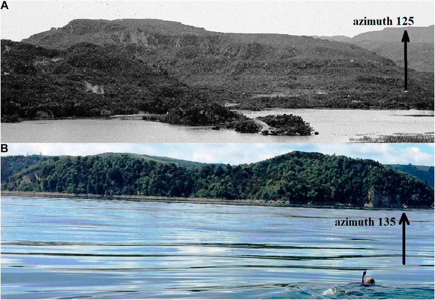
FIGURE 6. Rangipakaru Hill in 1885 (A) Burton Bros. Patiti Island in 2016 (B). (Ingrid Fisher). Note the 125° and 135° azimuths to orient the images. The author is scoping our first scuba dive off Tarata Peninsula.
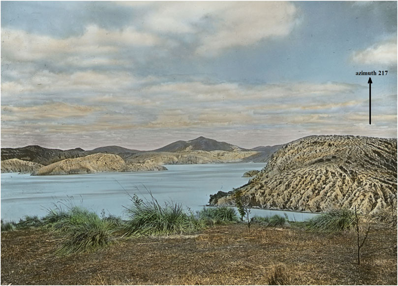
FIGURE 7. Patiti Island lantern slide c. 1910, taken from the Tourist Track landing on a 217° azimuth (Rose Archives, SUNY Brockport, Brockport, NY).
Had a field observer noted the coincidence of Banded and Rangipakaru hills in 1887, the Banded Hill−Tarata Peninsula distance is ∼800 m in Figure 3. This distance projected north from Te Rangipakaru in Figure 2 shows that the Tarata Peninsula ends over the Steaming Ranges above the Waikanapanapa Valley. In Figure 2, this valley bisected the Steaming Ranges and is considered the site of the Rotomahana phase of the Tarawera eruption (Keam, 2016). This further evidences that in 1886, the White Terraces could have been reported as lying buried north of the crater rim.
The Steaming Ranges appear in Figure 8 as Tarata Peninsula beyond the rim of Star Hill crater (marking Lake Makariri location in the foreground). Rangipakaru (Patiti Island) is to the left. In 1921, the land remained unvegetated, providing a Lidar-like perspective. It follows that as Tarata Peninsula continues north under the 1886 ejecta in Figure 8, the White Terrace spring must lie buried on land outside the crater as in Figure 9.
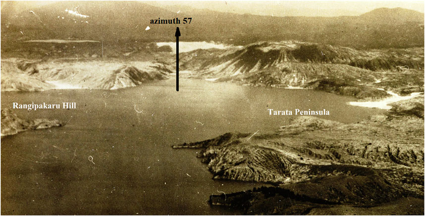
FIGURE 8. Lake Rotomahana, Rangipakaru Hill (now Patiti Island), and Tarata Peninsula c. 1921 looking southwest, along the rift azimuth at 57° (Cotton, 1921; Te Papa).
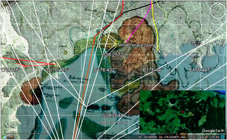
FIGURE 9. Georeferenced Steaming Ranges (in umber), over the Tarata Peninsula on Google Earth™, with Lake Rotomahana and White Terrace on the left and Lake Rotomakariri on the right. The river entry paths are shown and discussed. The overview map marks the location in the northern Taupō Volcanic Zone (Hochstetter’s 30 April 1859 map). Refer to Figure 1 for location details.
Tarata Peninsula, the Pinnacles, and Rangipakaru are navigation waypoints providing a route to the White Terraces. These should have led geoscience investigators to navigate to the White Terrace location using the maps available from 1864 and 1887. A backpacker, motorcyclist, or scuba team would use these waypoints in the Rotomahana crater today. I imagine the Arawa Māori elders navigated via these waypoints to satisfy themselves that the White Terraces survived the eruption. Investigators since 1886 have been oddly oblivious to the obvious.
In Figure 9, the area between the White Terrace and Tarata Peninsula is now a shallow lake inlet. Pre-eruption photography and georeferencing show this was an overlooked valley. This valley opened west and wound behind the Tarata embankment. It hosted the first two great boiling springs on the tourist path, Ngahutu and Ngahapu. Ngahutu Spring disappeared from the historical record, but this valley and its springs reenter the narrative for two reasons discussed herein. First, it contributed a low point to the post-eruption crater rim. Second, its springs each held ∼1.5 million liters of water.
3.2 Rotomahana crater watercourses
The fourth waypoints overlooked by all researchers from 1886 to 2023 are the watercourses in the Rotomahana Basin and crater. An examination of these enables the geospatial location of lakes Rotomahana and Rotomakariri and the White Terraces, after the 1886 eruption in Figures 2, 3, 5.
3.2.1 Rotomahana Basin streams exiting into old and new Lake Rotomahana
Note: Watercourses on this plateau are often dry due to percolation. This percolation is familiar to residents of Rotorua, where surface flooding is rare. Flow analysis at Lake Rotomahana in 2014 showed that 62,200 m3 of water percolates daily through the isthmus to Lake Tarawera (Bunn, 2014). The new Lake Rotomahana has no outlet stream. This is another overlooked signpost to post-eruption springs in reports from the time and by geologists to the present (Simmons and O’Sullivan, 2010; Keam, 2016). During and after the eruption, water flowed through the ejecta, carving piping and watercourses.
Apart from Hochstetter in 1859, no survey or large-scale mapping of the Rotomahana Basin was completed before the 1886 eruptions. Hochstetter and Petermann’s 1864 map showing lakes Rotomahana and Rotomakariri and associated streams is shown in Figure 2. Hochstetter mapped streams entering Lake Rotomahana from the south and east; one (Black Terrace Stream) from the west; and none from the north where the lake drained to Lake Tarawera down the Kaiwaka Stream (or Channel). No other pre-eruption watercourses west of Rotomahana are documented before 1886, although the topography suggests that they existed. The flow of surface water was west-to-northwest across the country to lakes Rotomahana and Tarawera and thence down Tarawera River to the Pacific Ocean.
3.2.1.1 Western streams
3.2.1.1.1 Black Terrace stream
The stream fed by the Black Terrace spring emptied into Lake Rotomahana north of the Pink Terrace between Te Whakataratara and Te Waiti in Figure 2. The seminal research on Black Terrace was published in 2017 and showed the occurrence of post-eruption spring flow there (Bunn, 2017a; Bunn, 2022b). Recently, this spatial research was extended to triangulate the locations of the Black Terrace spring, Black Terrace Stream, and Black Terrace Crater (Bunn, 2022b).
Today, as shown in Figure 5, five Strahler first-order streams drain Kumete Ridge to the east; one, the Wairua draining its western side, and one to the north. Three of the eastern streams drain the peaks along the ridge, entering the lake at Boat Launch Bay via Strahler fourth- and second-order streams. Two of these descend from Hochstetter’s landmark peaks “c” and “d” along the ridge (Bunn and Nolden, 2018). The “d” stream drains from the Te Kumete trig station. The main branch tracks over Black Terrace Stream beneath today’s forest road to Black Terrace and Black Terrace Crater in its Strahler third-order stretch. The River Pilot lists Black Terrace Stream here as Drain 1019568 (Land Information New Zealand, 2022). The drain deserves to be renamed.
These streams were noted by S.P. Smith in 1886 and, therefore, are probably on similar courses to their pre-1886 courses. Two more drain the eastern ridge and 1755276 is of pivotal interest to researchers, as it connects into the old and new Kaiwaka Streams in lower reaches. The other short northerly stream 1755688 now empties above Te Rata Bay. After studying contour lines, I consider that this stream on its pre-eruption course joined 1102173 and drained the eastern portion of Kumete north into Lake Tarawera. Today (like others) it is deflected southeast to join the Kaiwaka above its pre-eruption exit into Lake Tarawera. There are, to my knowledge, no reports of any stream entering the pre-eruption Kaiwaka from the west, only the Awaporohe from the east.
3.2.1.1.2 Eastern streams
In his 1886 map (Figure 3), Smith showed two streams debouching from the second and third gullies east of Rangipakaru Hill and tending toward the crater and Banded Hill (Smith, 1887). The three gullies and their streams lying between Waimangu and Lake Rerewhakaaitu are easily checked on today’s mapping and the River Pilot, for they exit into the new Lake Rotomahana in Figure 5 from the southeast.
3.2.1.1.3 Hangapoua Stream and Boiling River
Evidence existed of the pre-eruption topography in the Rotomahana–Rotomakariri crater from the first-responder visits in 1886 and for a decade while the crater lake filled. The first overlooked evidence was a hot stream flowing into the crater from south of the southern Pinnacles, southwest of Banded Hill. In Figure 10, the government investigators elected to name it Boiling River, though its branches entered the crater through the southern and southeastern walls, marking it as a pre-eruption feature. This was an enduring oversight (Smith, 1887).
FIGURE 10. Georeferencing showing the Boiling River branches in Smith’s 1886 map superimposed over Hangapoua Stream on Hochstetter’s 30 April map. It connects with streams 1283784 and 1283810. The Waiahinekahu connects to the existing stream 1102186. Note the three eastern gullies, issuing these streams then and now. The overview map marks the location in the northern Taupō Volcanic Zone.
When georeferencing Smith’s 1886 and Harding’s 1887 Rotomahana crater maps on Google Earth, (using Banded Hill and the southern embayment wall as control points in Figure 10), the Boiling River lies beneath the Hangapoua Stream course (Thomas, 1887). This stream entered the old lake at its southeastern corner, below lakes Ruahoata and Wairake. It is marked on August Petermann’s (1822–1878) 1864 map, which was commissioned by Hochstetter and familiar to the government’s General Survey Office delineators (Hochstetter and Petermann, 1864a). Today, the Boiling River−Hangapoua upper reaches are found on the River Pilot as streams 1283784 and 1283810.
Up to 1938, the area where these streams would enter the new Lake Rotomahana was dry land, as observed by James Healy OBE (1910–1994) the Rotorua town geologist (Healy, 1975). These Strahler second-order streams arise from the first and second gullies east of Waimangu on topographic mapping in Figure 10, and on Hochstetter’s maps (Figure 2).
3.2.1.1.4 Waiahinekahu Stream
More obvious was the second, unnamed stream marked by Smith, which entered the crater through the southeastern crater wall, east of Banded Hill (Figure 10). This Strahler second-order stream fed a pond in the crater floor. Its crater entry east of Banded Hill was another navigation aid for the Waiahinekahu Stream is marked on Hochstetter’s manuscript map and his published map at that location in Figure 2. Formerly, it wound around Rangipakaru Hill and fed Lake Rangipakaru. Smith marked its characteristic sickle-shaped course toward the crater on his map pointing at Banded Hill (the pre-eruption Te Rangipakaru) in Figure 10. This evidence has been in plain sight since 1886. The upper reaches of the Waiahinekahu can be seen today in stream 1102186 arising in the third easterly gully on Smith’s map and the River Pilot in Figure 5.
3.2.1.1.5 Station 21 stream
A third, (unnamed) first-order stream entered old Lake Rotomahana between the Haumi and Hangapoua streams, below Hochstetter’s observation Station 21. It is marked on his 30 April 1859, map and in Figure 2. This can be seen on the River Pilot and topographic mapping as Stream 1283776. Its lower course has, like others, been altered by the eruption.
3.2.1.1.6 Acid River
On Smith’s map in Figure 3 a fourth stream entered the northeast crater, joining a fifth stream on the crater floor. The government surveyors labeled the fourth as a new stream, Acid River, which exited into ponding on the crater floor, which they named new Lake Rotomakariri. This stream is mapped only on Hochstetter’s 29 April map and may have drained Lake Rangarua. It is today stream 1050539, a Strahler first-order stream entering the lake in the northeast corner. The northern branch would be stream 1102189, which today drains Mount Tarawera.
A sixth, first-order stream entered the crater east of Banded Hill, draining into a small pond. Its pre-eruption course is unclear, but it may have drained Lake Rangarua. A branch of the Waiahinekahu Stream is probable.
In summary, the three southeastern pre-eruption streams entering the old lake below Rangipakaru Hill appear on Hochstetter’s 1859 map, his 1864 published map (Figure 2), and Smith’s (1886) maps (Figure 3). They can be traced on today’s River Pilot and topographic mapping. But why did not Smith or generations of geoscience researchers join the dots connecting the streams to old Lake Rotomahana and its terraces? Given the bases of Māori mental mapping, these watercourses around the 1886 crater would have been interpreted by Ngāti Rangitihi and Tūhourangi elders as they assessed where the old lakes and terraces lay.
3.2.1.2 Southern streams
3.2.1.2.1 Haumi Stream
Stream 1502345 is marked on Hochstetter’s and Peterman’s mapping from the southwest in Figure 2. It drained Lake Okaro as it does again after a hiatus of ∼76 years. The lower reaches are renamed Waimangu Stream. This stream was blocked below Lake Okaro by the 1886 eruptions and did not run freely until the 1960s (Bell, 1906; Cross, 1963). In 1887, it should not have been drawn entering the Rotomahana crater (Thomas, 1887). The Haumi never flowed into the crater, until long after the crater filled to become the new Lake Rotomahana. The pre-eruption Haumi stream is shown on our georeferencing to coincide with today’s Waimangu Stream exit into the new lake, allowing for >12 eruptions which carved the valley entrance into its present configuration and erosion.
3.2.1.2.2 Northern streams
No streams entered old Lake Rotomahana from the north. Today, only three short streams drain Mount Tarawera into the new crater lake from the north.
3.2.2 Kaiwaka Channel
3.2.2.1 Pre-eruption Kaiwaka
Note: Given its forensic importance, the Kaiwaka Channel analysis is divided into pre- and post-eruption sections.
Only one stream exited old Lake Rotomahana. This has focal significance for the locations of the White Terraces and the old lake. The Kaiwaka Channel (or Stream) was the only waterborne tourist access to the terraces. Tourists transshipped from dugout lake canoes at the Kaiwaka exit into Lake Tarawera. In another error from the period, there was no village called Te Ariki at this exit. The nearest Tūhourangi Village was Kokotaia, which was located ∼500 m away around Rapatu Bay at NZAA site V16/70 (Bunn, 2017b; New Zealand Archaeological Association, 2018). Guests were poled or pushed up the steep, strong-flowing Kaiwaka, which drained Lake Rotomahana beside the White Terraces. Many tourists wrote about their alarming transits down the Kaiwaka. Hochstetter described his: “The Kaiwaka, the outlet of the Rotomahana … The word signifies canoe-eater or canoe-destroyer, probably from the rapids which are to be passed in the river, as canoes there strike the ground and are easily damaged” (Hochstetter, 1867).
In his 1887 eruption report, Smith noted: “… a strong stream of hot water formed the Kaiwaka river, which after a course of a mile, and a descent of 40 ft, fell into Tarawera Lake …” (Smith, 1887).
After the eruption, the first government survey report was unsatisfactory, and a second team was sent led by S.P. Smith. His report to parliament was flawed and hedged. It contributed to mistakes on the public record concerning the Pink and White Terraces. Smith’s 1887 report on the Terraces concluded: “The exact position of the [White] terraces cannot be identified, as the ground around where they formerly stood, has been blown away; but they evidently were close to, and to the northwest of the pinnacles … The site of the Pink Terraces cannot be identified with more certainty than that of the White Terrace” (Smith, 1887). Smith mentions that sinter had been found nearby, but was apparently unseen by him. Sinter occurred at many sites around this lake, not just at the terraces.
The likely reason for Smith’s inability to be more open on the locations and status of the terraces was that as Assistant Surveyor General, he was embarrassed by his department’s failure to complete a survey of the terraces, the greatest tourism asset in the country. His inability to accurately locate the terraces left the question open for 130 years until Hochstetter’s 1859 Terrace survey arrived back in New Zealand. In Smith’s 1887 report, the terraces appeared destroyed, which caused public anguish (Warbrick, 1934).
Smith’s (1887) report on the Kaiwaka concluded: “It was at a point due north from the centre of the lake that Kaiwaka River flowed out of Rotomahana. The valley has been completely filled up with sand and mud to a depth of 80 ft [24 m], forming as it were a great dam … though within a quarter of a mile of the crater rim, the hollow, deepening into a valley now occupied by a watercourse, can be seen and followed out to its junction with Lake Tarawera” (Smith, 1887). Smith drew the large-scale map for his 1887 report but did not publish his thoughts on the Kaiwaka, valley detail, watercourse, old lake coordinates, or the Awaporohe River. His unpublished 1886 manuscript map sketched the entry in a reentrant in the crater rim, at an azimuth of 17° (Smith, 1886).
In 1887, Harding first sketched locations for the old lake, the Kaiwaka, Awaporohe, and Hangapoua streams. These may have been suggested by Algernon P.W. Thomas (1857–1937) for whose report Harding drew this map (Thomas, 1887). His lake is 6% larger than the published Hochstetter map. It is closer to our surveyed lake size. His White spring positioning does not follow his superior, Smith’s report as Harding has the spring and terrace due north of the Pinnacle, where Smith says they lay to the northwest where we locate them. His Boiling River is superimposed on the Hangapoua. His Kaiwaka entry and Kaiwaka−Awaporohe entries gap are displaced eastward but at ∼1,070 m, his gap is consistent with our georeferenced gap. His Kaiwaka entry lies at an azimuth of 25° and differs from Smith in position. Harding placed his Kaiwaka entry in the rim cleft, which as reported herein, was formed above the Ngahutu Valley. This appears to be a desk mistake by the General Survey Office staff. Given the chaos along the crater rim in 1886 from eyewitness accounts, photographs, and artwork, no other landmark existed for this Kaiwaka−Awaporohe depiction by Harding. It seems to be an invention. In 1894, Smith published a large-scale map of the Rotomahana crater including Harding’s depiction of the old lake inside the new (Smith, 1894). Smith’s (1894) Kaiwaka entry position differs from Harding’s and his earlier efforts, lying now at an azimuth of 57°. These changes underline the artistic license applied to the Kaiwaka Channel.
Harding’s speculation was adopted in the absence of other cartography and persists. Nearby on the Rotomahana crater rim, a low point developed providing a convenient point to relate to Harding’s map. The Rotorua District Council installed an overflow pipe there in 1974 (Paterson, 2003). Generations of geologists followed Harding and adopted this overflow as the site of the New Kaiwaka datum.
3.2.2.2 Awaporohe Stream
This short stream drained Lake Rotomakariri to the north and joined the Kaiwaka before it emptied into Lake Tarawera, beside Pukekiore Hill. Their junction lay north of the fourth silica terrace at Tamariwi. Little was documented about this stream. It was sufficiently large to warrant a moored canoe where it crossed the tourist path. Hochstetter included it on his maps but never reached the stream or Lake Rotomakariri. It lay beside the Steaming Ranges to the east, as the Kaiwaka lay on its west. The stream entries were separated by ∼1,000 m by the Steaming Ranges. We georeferenced the junction of the two streams in 2018.
3.2.2.3 Kaiwaka Channel—post-eruption
After the eruption, a great watercourse was seen on the Rotomahana isthmus, between lakes Rotomahana and Tarawera, beginning ≤1,200 m below the crater. Smith recalled that the Kaiwaka exited the old lake at its northern end but was unable to position the old lake, the Kaiwaka, or the terraces relative to the crater beyond a guess. He recalled that the Kaiwaka was a mile long and was able to walk the lower third of it, for water flow had carved through the ejecta when the first rescue teams arrived days later (Figure 11).
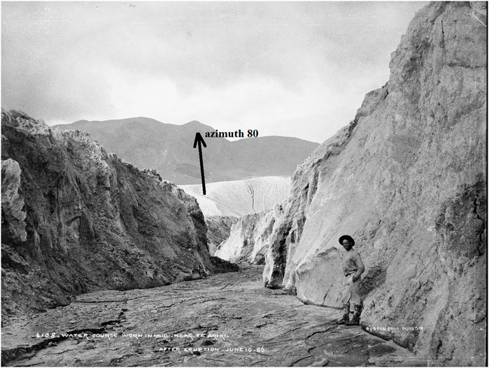
FIGURE 11. Kaiwaka Lower section, probably by Charles Spencer (1854–1933), for Burton Brothers, Dunedin, over 13–18/6/1886. The 80° azimuth is (approximately) on Koa Peak (MA_1043612 Te Papa).
In Figure 11, the erect man (∼1.7 m height from WWI army biometrics), enables measurement of the watercourse at ∼11 m wide and ∼9 m high. This is a section of the pre (and post) eruption Kaiwaka, in the lower third before Pukekiore Hill. It is almost as wide as the Tarawera River entry and aligned on Koa Peak. Runnels inside the watercourse indicate that it was antecedent. The size disparity shows that the course carried a major water flow during and/or after the eruption, which lasted 2 h as F.W. Hutton (1836–1905) reported: “At about 0330 h the activity on Wahanga and Ruawahia became more explosive … At the same time Rotomahana burst into eruption, throwing out a column of steam higher than that from Tarawera” (Hutton, 1887). Jim W. Cole states: “It was an explosive eruption, charged with the soft lake sediments of the old lakes Rotomahana and Rotomakariri, as well as volcanic rock intensively altered by earlier thermal activity, to form the Rotomahana Mud. The eruption was largely over by 0530 h” (Cole, 1970).
Nearly all the eruption surges carried to the west; hence, much airborne Lake Rotomahana water was dumped over and beyond Kumete Ridge rather than over the isthmus. Ian Nairn records one base surge passing over the Steaming Ranges position (Nairn, 1979). The Rotomahana eruption column was carried by south-southeast winds as it cooled and lake water vapor condensed. The 10–13 km column entered the stratosphere where water would not have condensed and fallen. The deposits near the lake itself were hot and dry (Nairn, 1979; 2002).
As the eruptions progressed southwest from Wahanga peak, the chasm eruption and that under Lake Rotomakariri likely preceded those under Lake Rotomahana. Cole suggested: “the explosions from The Chasm could have been caused by cold water draining from Lake Rotomahana into the eruptive fissure” (Cole, 1970). The chasm water would have come from Lake Rotomakariri to cause the chasm to erupt and to drain into the Chasm-Rotomakariri eruption fissure. Once the fissure extended under the Steaming Ranges, Rotomahana lake water would have drained into the growing fissural excavation” (Keam, 2016).
Cole states: “at the time of the eruption, superheated water, water vapour and liquid water would have boiled violently into the atmosphere” (Cole, 1970). Once this happened, natural water inflow at the Kaiwaka entrance ceased, save for continuing inflow from the White spring. However, a large water flow down the lower Kaiwaka watercourse appears in Figure 11. This occurred after the fall of ∼9 m of ash there on the night of 9 June and before the rivulets formed over the floor. It was evident by 13–15 June when rescue teams arrived and a warm stream of water still issued (Paterson, 2003). As no rain had fallen since the eruption, the rescue teams could not explain it. Some negotiated ∼300 m up this watercourse. They attributed the water to the Kaiwaka Valley, and the misconception was borne. None considered Tarata spring pumping above them. A 2014 Tarawera River volumetric study indicated that natural Kaiwaka outflow would have ended at the exit, about 1 h from the Rotomahana eruption, excluding spring water (Bunn, 2014).
Once the lake level dropped at the Kaiwaka entry due to inter-lake and fissural drainage and the eruption column, there was no lake water to account for this 100 m2 watercourse in Figure 11. The channel formed after Nairn’s northern base surge (Nairn, 1979). There was no rain. Nor can redeposited lake water account for the watercourse. Yet the evidence lies in Figure 11. The only source to carve out the great Kaiwaka watercourse both during and after the eruption was water from Te Tarata, the immense White Terrace spring, and nearby springs.
Our georeferencing of Hochstetter’s 30 April map shows the Tarata Spring located <100 m from Harding’s sketched Kaiwaka entry, which is ∼100 m from the rim saddle which formed. The two may be causally related. It lies close to the crater rim. As with Black Terrace spring, where continuing water flow fueled the 31 July eruption of Black Terrace Crater (Bunn, 2022b), it would continue pumping during the eruption until its supply pressure fell or its plumbing fractured. The rescue teams’ reports are consistent with a disturbance to the Tarata spring plumbing and water flows finding paths north through the ejecta to its pre-eruption course down the isthmus (Warbrick, 1934). How the Terrace springs continued pumping through the eruption is explained by geophysicist Keam: “a geothermal system is robust … it can survive major disruptions—even quite large volcanic eruptions through part of the same three-dimensional region it occupies” (Keam and Lloyd, 2016).
The basin volume and flow from the great spring and Te Aka Mānuka were sufficient to carve out piping within hours or days and connect with the original Kaiwaka course whose entry Hochstetter’s survey shows lay west of the saddle. This chain of evidence poses a question: why did Harding pick that spot on the crater rim for his Kaiwaka entry? Apart from the Ngahutu saddle depression, there is no sign of a stream entry draining north from the rim. In any case, the rim was ∼45 m above the Kaiwaka entry (Paterson, 2003). The rescue teams never approached the rim here as it was too hazardous. Moreover, the new surface there did not reflect the underlying topography (Nairn, 1979). Smith had a general idea of where the Kaiwaka entry lay and did not map it in 1886. It can only have been a guess by Harding.
The new Kaiwaka first appears in Harding’s 1887 map and Smith’s (1894) map, (Bunn and Nolden, 2018). On these maps, the watercourse is labeled as the start of the Kaiwaka Stream; however, the historical record and Smith’s report show no water flowing down the watercourse from the crater rim when he visited after the event. The new lake took 126 years to reach a height from which flow down this overflow channel could occur. The installed pipe only carries water when the lake occasionally overtops. The 1886 crater rim there was slightly lower forming a natural saddle as Keam describes: “in April 1974 an outlet culvert was constructed at the saddle where a natural overflow would have commenced had the lake ever risen sufficiently” (Keam and Lloyd, 2016).
The most likely reason for the saddle is shown in Figure 12. This shows it lies over the Ngahutu Valley, the valley between the White Terrace and the Steaming Ranges. The saddle has nothing to do with the Kaiwaka Channel. Harding’s artistic license with the Kaiwaka was accepted in 1887. Geologists to date have followed it. The rim saddle became the old Kaiwaka entry. The evidence herein shows it was not.
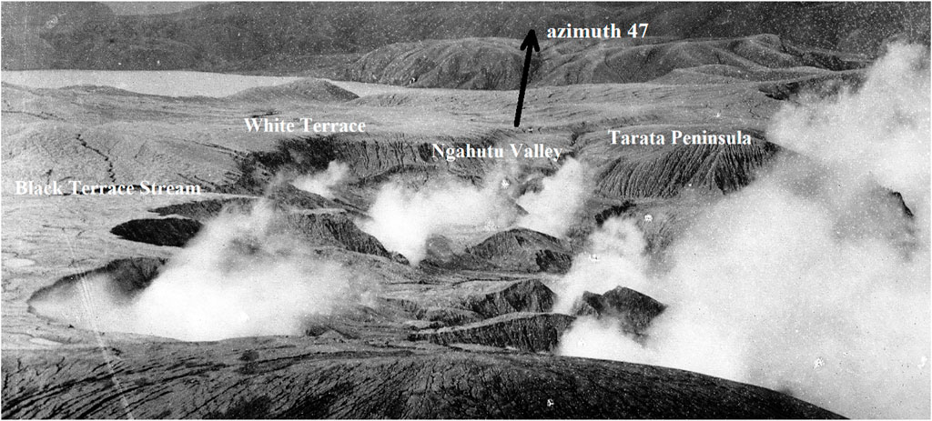
FIGURE 12. Muir’s photograph (cropped) of the northwest crater in late July–early August 1886. Black Terrace Stream and surface water are visible beside the near embayments, looking northeast at azimuth 47° (Te Papa MA_1023507).
3.3 Rotomahana basin lakes
The total pondage in the Rotomahana Basin was far less than geologists guessed. Volumetric analysis of the basin lakes from Hochstetter’s cartography, Smith’s report, and Alfred Warbrick’s and my field bathymetries indicate the basin contained ≤6 thousand million liters (0.006 km3) of impounded water.
This contrasts with Andrews’ estimate: “The volume of the environmental pre-eruptive total water volume is approximately 0.1 km3 (100,000 million liters), with the assumption that the entire volume was catastrophically removed or converted to steam during the eruption …” (Andrews, 2014). His provision is 17 times the actual basin pondage. His 0.1 km3 figure is probably a simple ratio estimate including surface and groundwater; hence, groundwater does not explain this variance (Cole, 1970).
The 1886 government survey teams noted water in the crater, some of which was redeposited lake water. I estimate the post-eruption crater water, from Smith’s and Harding’s mapping and reports, amounted to 1,367 million liters i.e., a quarter of the pre-eruption Rotomahana Basin water volume collected in the crater, in the weeks following the eruption. This is consistent with the 2014 catchment inflow to Lake Rotomahana of 62,000,000 liters per diem (Bunn, 2014).
As in Figure 13, Hochstetter described the Rotomahana Basin between Lake Rotomahana and Mount Tarawera thus: “Before leaving lake [sic] Rotomahana, the warm lake, however, I must also make mention of the Rotomakariri, or the cold lake, situated East of the Rotomahana at the foot of the Tarawera mountain” (Hochstetter, 1867).
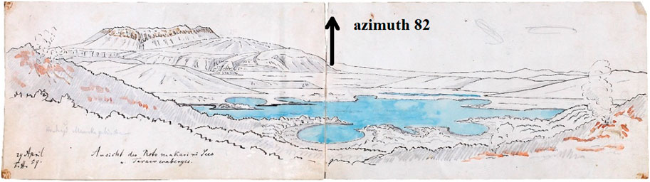
FIGURE 13. View of the Rotomakariri (cold lake) with the Tarawera mountain looking east, by Ferdinand Hochstetter, 29 April 1859 (Nolden & Nolden, 2013: 82).
He continues: “It is smaller than the Rotomahana and shows very remarkable circular coves reminding me of the circular tuff-crater basins in the vicinity of Auckland. However, having seen the lake only from the heights above the Rotomahana, I am not able to say how that phenomenon is to be explained. East of the Rotomakariri, there is another little water-basin, surrounded by swamps, and the joint outlet of both is the Awaporohe, which unites with the Kaiwaka river” (Hochstetter, 1867).
Cole described the basin: “There were two main lakes in the basin, the warm Lake Rotomahana and the cold Lake Rotomakariri. Lake Rotomahana was shallow and flowed out through Kaiwaka Stream into Lake Tarawera. Lake Rotomakariri was surrounded by numerous small sinter cones and flowed out through the Awaporohe Stream. Te Waingongongongo, the area between Lake Rotomakariri and Mount Tarawera, was swampy” (Cole, 1970).
3.3.1 The old and new Lakes Rotomahana
The old Lake Rotomahana is shown in Figure 2 (with the caveat that this published map by Petermann has 12 known defects. However, the legend is more legible). As the old and new crater Lakes Rotomahana are well documented in our papers, here I focus on those poorly documented lakes of the Rotomahana Basin (Bunn and Nolden, 2016; Bunn and Nolden, 2018: Bunn et al., 2018; Bunn, 2019b).
3.3.2 Lake Rotomakariri
This unusually shaped lake translates as the Cold Lake, versus Rotomahana the Warm Lake (a misnomer, for the mean temperature was ∼26°C). It was described by Smith:
“Lying between Rotomahana and the base of Tarawera Mountain, and about a quarter of a mile from the White terraces, was Rotomakariri, the cold-water lake, with an area of about twenty or twenty-five acres, between which and the mountain was a swampy valley called Waingongongongo…” (Smith, 1887).
A later description (paraphrasing Hochstetter and Smith), published by Sir Robert Stout (1844–1930) provides some idea of the lake’s dimensions and area.
“About a quarter of a mile to the east of the White Terrace was Rotomakariri, a lake of cold water, as the Maori name indicates, This was only one-third of a mile in length from west to east, and about half as much in width. Its shores showed numerous circular cones, which, Hochstetter states, reminded him of the volcanic tuff-craters of the neighbourhood of Auckland. Around Rotomakariri the ground was swampy, and several smaller pools of water occurred here” (Stout, 2016).
Stout’s paper describes Rotomakariri as ∼536 m by ∼270 m. Given its generally elliptical shape, the lake area was ∼28 acres. This compares with Smith’s estimate of 20–25 acres. Based on our georeferencing of the three maps showing Rotomakariri (Hochstetter 29 and 30 April and his published 1864 map); the areas are 47 acres by Hochstetter 29 April, 56 by his published map, and 79 acres by Hochstetter on 30 April. Estimating distances over water is subjective and variance is expected. Moreover, the shorelines of shallow lakes are mobile.
East of Lake Rotomakariri lay an unnamed lake of ∼10 acres which drained into Rotomakariri. I reference this as Lake Rotomakariri 2. Under Mount Tarawera, was the last named basin lake: Green Lake.
Smith estimated that Lake Rotomakariri was located about a quarter of a mile from the White Terraces. He does not give his location on the terrace and I adopt the observation station on Lucy’s Isle as his most likely datum. Lucy’s Isle is the forgotten name of the small island in the center of the White Terrace platform entrance (Bunn, 2022c). The western shore of Lake Rotomakariri lies ∼500 m east of Lucy’s Isle, consistent with Smith (Bunn, 2022c). Lucy’s Isle first appears in the literature in 1885 (Cowan, 1885). As Hochstetter documented the island in 1859 and omitted to name it, it is safe to presume it was named in the interim. Tribal permissions for the landform naming and the person’s name must have come from Te Tūhourangi. The likely individual is Ruihi (Lucy), the wife of Te Rangipūawhe (1826–1905), the ariki (paramount chief) of Te Tūhourangi (personal communication: Rangitihi Pene, 26 September 2022) (Talbot, 1882).
Hochstetter’s maps developed over his weekend visit in 1859. On 29 April, he drew Lake Rotomakariri for his diary based on aerial-oblique glimpses the day before from Kumete Ridge. His second draft was from the south, probably en route to Rangipakaru Hill and with a poor perspective from the flats. He first sketched a smaller lake lying perpendicular to the hill and with the tuff craters. He labeled it Kreis See (Circle Lake). His Awaporohe stream tracked out of sight north along the hillside. This draft was corrected to capture the size and orientation of the lake, parallel with the Steaming Ranges and with the Awaporohe and Kaiwaka junction included (Figure 2).
This correction may have taken place later at Te Mu, where he relates: “…the constant heavy rain preventing our departure … This delay was quite welcome to me, because by it I found time to finish the topographical sketches, deriving great benefits for my purpose from the excellent local knowledge of Mr. Spencer” (Hochstetter, 1867).
Hochstetter’s third lakes map of 30 April reproduced the size and orientation of his second draft at twice the scale. He did not reach the Rotomakariri shores, and it remains in outline on this defining Rotomahana map. This correction to the maps of Rotomakariri may have been the cause of Petermann’s mistaken depiction of Rotomakariri in his 1864 map in Figure 2. Petermann showed Rotomakariri perpendicular to the Ranges rather than parallel to it and displaced it south (perhaps as a larger Circle Lake). His mistake was accepted from 1861 until Hochstetter’s 30 April 1859 lake map was published in 2011.
3.3.3 Lake Rangarua Tapu
Below Lake Rotomakariri 2 and east of Waikanapanapa Valley lay another lake of ∼10 acres, one Hochstetter named Lake Rangarua Tapu. This kidney-shaped lake does not appear further in the literature. Hochstetter was given the name by guide Akutina Rangiheuea (? −1886). It connotes a spiritual significance for the Tūhourangi (or perhaps the Ngāti Rangitihi) for a literal translation indicates a sacred crater involving a group of people.
3.4 Mātauranga Māori
The topographic, watercourse, and lake navigation waypoints were relevant under Mātauranga Māori: the Māori topographic knowledge of the Rotomahana Basin. The extensive topographic nomenclature throughout the basin as evidenced in Hochstetter’s survey shows a developed Māori spatial mental map existed for their navigation across the region (Barton, 1998).
The leading published exponent of Mātauranga Māori for the region and period was Alfred Warbrick. He was the first Ngāti Rangitihi guide on the Terraces from 1885 and organized the first rescue teams in June 1886. After the eruption, he became the government Chief Guide at the new Waimangu Valley tourism attraction for 25 years. In his 33 years at the Rotomahana Basin, he reported finding no terrace fragments either on the surface or exposed by erosion. In 1936, on the 50th anniversary of the 1886 eruption, he gave his last interview (Warbrick, 1936):
“I am certain they are there to be rescued … I use the word 'rescued' deliberately. I admit that some men of my generation who were familiar with the Terraces and the general terrain of the region were as certain of their destruction as I am of their survival. It is an old controversy.”
“For the benefit of people of the younger generations it is necessary to explain that prior to the eruption there had never been a survey of the lake which would have fixed points from which the sites of the Terraces could have been accurately determined. I realise that in the absence of preexisting Survey maps theories as to the survival of the Terraces run the risk of being dismissed as personal opinion.”
“Had they been shattered in that vast upheaval, a convulsion which threw debris thousands of feet into the air, is it not reasonable to assume that some fragments of the easily identified material which formed them, would have been found? Not a piece of it has ever been picked up over the area." (Warbrick, 1936).
Had Warbrick known a terrestrial survey existed, he would have prosecuted his campaign to recover the terraces more forcefully in 1886. In this last 1936 interview, he reprised his plan to recover the Terraces:
“ … The scheme I suggest is the one I have advocated for years—that the waters of Lake Rotomahana should be lowered by 50 feet or 60 feet, a simple task requiring only the reopening of the old Kaiwaka channel into Lake Tarawera; and that then the steep shores at places I have marked should be excavated by means of sluices. A strong nozzle at each point would speedily remove the mud and ash deposit and prove, once and for ever, whether the Terraces exist." (Warbrick, 1936).
Ironically (and not having read Warbrick), I proposed a similar engineering method in 2014 for the PAWTL (Pink and White Terraces Limited) Project using siphons and Heron’s fountains (Bunn, 2014).
In his final 1936 interview, Warbrick inserted black arrows in Figure 14 pointing to the lake shores where he judged the buried Pink and White Terraces lay. His Pink Terraces lie in the second small bay below Boat Launch Bay and the White Terraces are a little west of Tarata Peninsula. The white arrows point to our Terrace locations in 2022 based upon the fifth and sixth iterations of Hochstetter’s survey and this geospatial paper. The 1936 and 2022 arrows point to the same shoreline locations. This vindicates Warbrick’s claims from Mātauranga Māori after 136 years while validating Hochstetter’s survey and the revised topography in this paper.
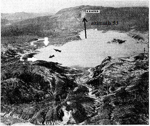
FIGURE 14. A c. 1936 aerial photograph of Lake Rotomahana, taken from the southwest. Warbrick’s 1936 black arrows point to his shoreline locations of the Terraces: the Pink Terraces in the second small bay below Boat Launch Bay and the White Terraces a little west of Tarata Peninsula. Based on Hochstetter’s survey, the white arrows point to our 2023 Terrace locations. The 1936 and 2023 arrows point to the same locations (New Zealand Herald, 16 May 1936, by permission).
Two of the navigation waypoints, Banded Hill with the Watercourses, confirm the location of Te Rangipakaru. Tarata Peninsula and Banded Hill determine that the White Terrace spring location is outside the crater. The addition of Mātauranga Māori probably enabled Warbrick to be more precise on the terrace locations in Figure 14. The 1907 Tohunga Suppression Act makes it difficult for us to research this. Hochstetter’s survey georeferencing is required to accurately establish the terrace coordinates outside the crater.
3.5 Terrace spring flows
Photographic evidence of terrace spring flows continuing after the Pink and White Terraces’ eruption is presented. The flow from the Black Terraces spring is documented elsewhere (Bunn, 2022b).
3.5.1 Post-eruption Pink Terrace flow
Given the evidence of post-eruption water flow from the White Terrace spring (Figure 11), I reexamined hundreds of photographs for evidence of water flow from the third Pink Terrace. This was carried out without great expectation, for this spring was smaller and survey cartography showed it lay close to the rim. Given the chaotic landform at the crater rim, few apart from Alfred Warbrick ventured there. He explored this part of the crater on about 8 July 1886, descending on a one-inch Manila rope to look for the Pink Terrace. He reported hot mud rivers flowing near a mound he associated with the Pink Terrace but was forced to evacuate by a fresh eruption (Warbrick, 1934).
Figure 12 shows a photograph of the rim where this occurred, taken by Frederick Muir (1852–1945) weeks later, from Hapeotoroa Hill. We navigate this print from right to left. The northern pinnacles are on the right, with the buried Steaming Ranges to their left. Next is the Ngahutu Valley cleft (the saddle), and the buried White Terraces. On their left is Black Terrace Stream emptying into what is now Boat Launch Bay (Bunn, 2022b). Next are two small and a third larger bay (sometimes termed Otukapuarangi Bay). The second small bay is close to where our 2016 georeferencing first placed the Pink Terrace (Bunn and Nolden, 2016). Three survey iterations later, we fix it close to this bay. As Jim Healy noted, “the original shape of the crater is remarkably well preserved” (Healy, 1975), and these crater bays remain on topographic mapping. Note the surface ponding between the second and third bays at nine o’clock.
Figure 15 shows a cropped photograph of this same area by Spencer, taken earlier that month. Water flows in Black Terrace Stream (white down arrows) as recently reported (Bunn, 2022b). South of this, between the second small bay and Otukapuarangi Bay, are collections of surface water. There are ∼20 ponds. On enlarging this photograph, one of these ponds (white up-arrow) appears right-sloping at 6°. This is unlikely to be lens barrel distortion given that the section is not central in the negative. The camera is level (using a plumb bob), and the print seems within normal limits. Rectilinear lenses were in wide use. Still water has a fluid level and does not slope. The distal portion of Black Terrace Stream shares the 6° slope. These waters are running and the outline of a possible runnel connecting with the ponds is seen at maximum enlargement.

FIGURE 15. Spencer’s photograph (cropped) of the northwest crater in July 1886, looking northeast. Black Terrace Stream, surface water, and the runnel are arrowed (Te Papa MA_1396152) (image deterioration is likely from poor print fixing).
When we compare this section of the crater rim with our published fifth and sixth iteration Pink Terrace location in Figure 16, the ponding, runnel, and terrace share the location between Boat Launch and Otukapuarangi bays close to the 1886 rim and the 2022 shore. This is also Warbrick’s 1936 location.
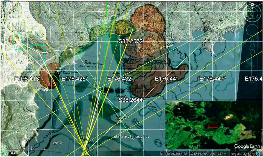
FIGURE 16. Our published iteration V–VI Pink Terrace spring location, lying along the same section of the crater rim in Figures 12, 15. (Bunn, 2019b). Hochstetter’s Pink Terrace spring bearing (in bold yellow) also strikes this spot, confirming Warbrick’s location. His White Terrace bearing (in bold yellow) also strikes the White spring. The overview map marks the location in the northern Taupō Volcanic Zone. Note that the survey stations and bearings in Figures 9, 16 were resected on different computers to replicate the findings. Refer to Figure 1 for more location details.
Previous researchers noticed surface water in this area and assumed it was rainwater or lake water from the eruption weeks before. The percolation and spring evidence herein provide a more credible explanation.
3.5.2 Post-eruption Tarata Spring flow
Unlike the topography of the Pink and Black Terraces, that around the White Terrace is complex. Cartography is of limited value while the large format, fine-grain photography from Mount Tarawera enables enlargement while retaining surface detail. In Figure 17, I show the Tarata Peninsula on the left and the White Terrace, separated by the Ngahutu Valley (so referenced as it is overlooked in historical records and is now underwater). A frontal view of this valley is inset. The Kaiwaka Channel is red, curving around to join the Awaporohe before its exit as Hochstetter and Smith observed. The Awaporohe Stream is yellow and enters 1 kilometer east of the Kaiwaka. Of Lake Rotomakariri. A surviving trace is Star Hill Crater in the eastern foreground. This appears to have erupted through one of the eastern tuff-crater basins in Figure 13. The new Lake Rotomahana overflow at the saddle is in mauve. Its watercourse merges with the Awaporohe, further explaining the early confusion. The main stream draining the Kumete Ridge, 1755276, is blue. As it follows the Kaiwaka course, it deserves the name.
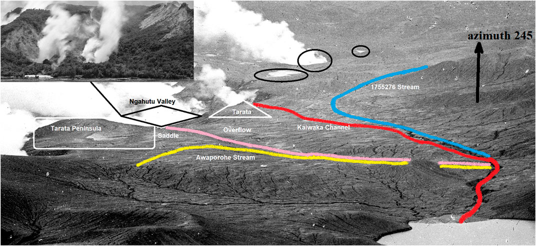
FIGURE 17. Post-eruption isthmus landmarks and streams looking west southwest along (approximately) azimuth 245° (Te Papa MA_1269460). Note: This 1886 Muir print is cropped and enhanced to improve watercourse visibility. Blue: main Kumete watercourse, red: Kaiwaka; yellow: Awaporohe; mauve: saddle overflow is mauve. The Black Terrace Stream, Black Terrace Crater, and Black Terrace are circled in black (left to right). The Ngahutu Valley is inset with the Ngahutu and Ngahapu springs. The Tarata (White Terrace) location is the same as Warbrick’s.
Little surface water was present over the isthmus apart from these watercourses and springs. This is negative evidence for the thesis that spring flows continued after the eruption and left evidence. The eruption on 31 July 1886, at the Black Terrace Crater demonstrates how spring water flow continued through June−July. Little rain fell between the eruption on 10 June and the photograph in Figure 11. Hence, part of the flow that carved out the enlarged lower Kaiwaka had to come from other sources such as Te Tarata, Aka Mānuka, Ngahutu, and Ngahapu springs. These eight springs contained ∼7–8 million liters (White Spring ∼3, Ngahutu and Ngahapu ∼1.5 each, and Te Aka Mānuka series 1–2)—sufficient to carve out the Kaiwaka below their junction (Hochstetter, 1867). The Awaporohe might also have contributed. Stream 1755276 would not have contributed until after significant rainfall. A recent meteorological study explained why the White Terrace spring (also the Black and Pink springs) would be prone to erupt during the Rotomahana eruption (Bunn, 2022c).
The architecture of the Tarata spring embankment appears unstable, unlike the Pink Terrace, where the embankment was broad, low, and stabilized by vegetation with a <45° batter. As shown in Figure 18, the White embankment was tall, with a cliff-like 70–90° batter (Hochstetter, 1867). It was unvegetated along its fretted northern wall. The northern cliff was narrow with a saddle connecting into Orangiaho (Flat Top Hill). Here on the northern extremity of the Steaming Ranges lay five more boiling springs, the largest of which was Te Aka Mānuka (The Mānuka Vine). These springs drained north into the Awaporohe and Kaiwaka streams. Should the saddle fracture during earth movement, the six springs (eight including Ngahutu and Ngahapu), could drain north forming the overflow channel and, thence, into the Awaporohe–Kaiwaka river system in Figure 2.

FIGURE 18. Fretted northern embankment of the White Terraces (Te Tarata), arrowed looking east with Orangiaho to the north. White Terrace, Rotomahana, (cropped) by Burton Brothers, Alfred Burton (Te Papa C.010595).
In summary, evidence exists of surface water and flows from the three Terrace springs during and after the eruption. We know the new Lake Rotomahana passes ∼2.6 million liters per hour into Lake Tarawera; given the same catchment areas for the old and new lakes, this must be similar to the pre-eruption Kaiwaka flow. For example, had the Tarata, Ngahutu, Ngahapu, and Aka Mānuka springs emptied on the night, their combined flow was sufficient to fill the Kaiwaka for about 2 h: coincidentally the period of the Rotomahana–Rotomakariri eruption.
4 Discussion
The topographic and riverine evidence in this paper has been available for 137 years. This examination integrates the historical record, cartography, photography, topography, altimetry, and Mātauranga Māori records. This canon forms a new paradigm for the Rotomahana Basin. The research traces the chain of navigation waypoints leading to the White Terraces’ location and triangulates this with terrestrial surveys and Mātauranga Māori mental mapping to validate the findings. The research hypothesis is accepted, i.e., that the surveyed White Terraces location is buried under ejecta from the 1886 eruption and is verified by triangulation.
Much of this topography was common Māori and public knowledge in 1886. While some visitors, for e.g., Edward Payton (1859–1944) and all Māori tribal elders together with Chief Guide Alfred Warbrick, recognized it, the powerful government General Survey Office staff wrote the official eruption account and disregarded the evidence.
With interdisciplinary hindsight and Hochstetter’s Rotomahana survey, this geospatial paper revises the historical record for the Rotomahana–Rotomakariri eruptions of 1886 across the Rotomahana Basin. There was sufficient, even abundant, evidence in the days after the eruption for rescue teams, the General Survey Office, and academic teams to locate the shoreline of the old Lake Rotomahana and the Pink, Black, and White Terraces in the absence of a survey. The government overlooked the existence of Hochstetter’s survey.
Banded Hill (Te Rangipakaru) and the Tarata Peninsula lay in plain sight of the first responders. The peninsula was associated in government reports with the Steaming Ranges and the White Terraces. It is clear that the White Terraces lay on the northwestern tip of this buried hill and must, therefore, lie outside the 1886 Rotomahana crater and the new crater Lake Rotomahana. However, this realization did not appear in the General Survey Office maps published in 1886, 1887, and 1894 (Smith, 1894). Rangipakaru Hill, the Pinnacles, and the Tarata Peninsula formed a topographic Chain of Evidence that was overlooked by colonial and all later investigators.
No effort was made to associate the rivers observed and named in the crater with known rivers, which soon percolated into the Rotomahana crater. These streams provided researchers with a means of positioning old Lake Rotomahana relative to the crater and enabled more accurate navigation to the Pink and White Terraces in 1886. Instead, the government’s General Survey Office left this to Thomas and Harding, who attempted to position the old lake and Terraces by sketching imaginary paths for the Haumi and Hangapoua streams in the crater. Ironically, the only stream they connected with an extra-crater, pre-eruption path was the Haumi. This was blocked by the eruption; hence, their sketched course was confected. The Haumi never entered the Rotomahana crater. They superimposed the Hangapoua over a crater feature named Boiling River but did not attempt to follow this outside the crater. Had they carried out so, the pre-eruption topography would have been revealed.
Instead, the General Survey Office effort was placed on the streams exiting the old lakes; i.e., the Kaiwaka and Awaporohe. The early field reports were conjectural and accepted by the General Survey Office into their government mapping. The amalgam of official, local Rotorua (excluding Māori), and academic field reports was constructed into the official eruption record, which put the public into a state of grief over the lost terraces. Given the lack of evidence in the General Survey Office reports, a public debate erupted and continued until the 1940s when the eruption generation passed on.
Only now, with this new topography, Mātauranga Māori, and Hochstetter’s terrestrial survey can we reconstruct the events impacting the Pink, White, and Black Terraces on that winter night in 1886. The layers of evidence published by Nolden and Bunn from Hochstetter’s survey diaries, maps, and 1860 Folio (Bunn and Nolden, 2023), together with the spatial, topographic, and Mātauranga Māori research corrects the historical record for the Rotomahana Basin.
Should traditional landowners elect to excavate the terrace sites this research will aid in the accurate field investigation. One day New Zealand’s lost Wonder of the World may again be revealed to the public gaze as Alfred Warbrick sought.
4.1 Elements of the new paradigm for the Rotomahana Basin
The key findings from these crater, lake, and river topographic analyses are shown in Figures 9, 17.
4.1.1 The Tarata Spring and scaled outline of White Terrace is shown in yellow.
4.2.2 The Brown Kaiwaka entry bearing ray from Hochstetter’s Observation Station 21 strikes the georeferenced location of the old Kaiwaka entry.
4.2.3 The Kaiwaka is in red, from Hochstetter’s survey, maps, and photography, together with today’s topography, contours, and vegetation.
4.2.4 The mauve ray is best called Harding’s Mistake and follows the Awaporohe course down the isthmus, connecting with the Kaiwaka.
4.2.5 The yellow path is the initial course of the Awaporohe, based on Hochstetter’s 29 April map.
4.2.6 The white path is the final course of the Awaporohe, based on Hochstetter’s 30 April map.
4.2.7 The Black path follows the Haroharo caldera in a series of coincidences with the Kaiwaka. These include superimposed crossings at the crater rim, parallel courses in the lower Kaiwaka, their second superimposition at the Kaiwaka exit, and their paths curving together around Pukekiore Hill (Tontini et al., 2015).
Note: Paths 4.2.4─4.2.6 join the Kaiwaka as it passes under Pukekiore Hill, consistent with historical records.
Other key Hochstetter survey findings in Figure 16 include:
4.2.8 Patiti Island overlaps Rangipakaru Hill.
4.2.9 The Black Terraces location at 9 o’clock.
4.2.10 The Steaming Ranges in umber.
4.2.11 The Pink Terraces location, verified by Hochstetter’s bearing in yellow striking the spring, as does the White Terraces bearing.
4.2.12 Hochstetter’s observation stations: his yellow rays leading to distal landmarks.
4.2.13 Green search boxes for Black Terrace and Black Terrace Crater.
4.2.14 The shore between the Pink and White Terraces, where the crater and old and new lake shores overlap.
4.2.15 The Ngahutu Valley between White Terrace spring and Waikanapanapa Valley is shown in the inset in Figure 17.
4.2.16 The basin lakes now have evidence-based altimetry in Figures 2, 16 (Bunn, 2022a).
Data availability statement
The original contributions presented in the study are included in the article, further inquiries can be directed to the corresponding author.
Author contributions
The author confirms being the sole contributor of this work and has approved its publication.
Funding
This research was self-funded by the author, in the public interest.
Acknowledgments
The author acknowledges an ongoing collaboration with Sascha Nolden, without whom this research at the Rotomahana Basin would not have been possible. A preprint of this manuscript was lodged with EarthArXiv at 10.31223/X50D29.
Conflict of interest
The author declares that the research was conducted in the absence of any commercial or financial relationships that could be construed as a potential conflict of interest.
Publisher’s note
All claims expressed in this article are solely those of the authors and do not necessarily represent those of their affiliated organizations, or those of the publisher, the editors, and the reviewers. Any product that may be evaluated in this article, or claim that may be made by its manufacturer, is not guaranteed or endorsed by the publisher.
References
Andrews, R. G. (2014). Approaches in experimental Volcanology: Bench-scale, field-scale and mathematical modelling of maar-diatreme systems. Thesis. Dunedin, New Zealand: University of Otago.
Barton, P. L. (1998). “Maori cartography and the European encounter,” in The history of cartography. Editor D. Woodward (Chicago, IL: Univ. of Chicago Press), 493–532. Book 3.
Bell, J. M. (1906). The great Tarawera volcanic rift, New Zealand. Geogr. J. 27 (4), 369–382. doi:10.2307/1776237
Bennett, W. (1954). The eruption of Mt Tarawera, interview NZBS 10/6/1954, 5.47–6.19. Available at: https://ngataonga.org.nz/collections/catalogue/catalogue-item?record_id=206243 (Accessed 2 13, 2022).
Bunn, A. R. (2017b). A note on Te Ariki. Conference. Available at: https://www.researchgate.net/publication/360560179_A_Note_on_Te_Ariki (Accessed 5 19, 2022).
Bunn, A. R. (2022c). Coandă and venturi effects at the Eighth Wonder of the World─ the white terrace. New Jersey: Authorea. doi:10.1002/essoar.10511924.1
Bunn, A. R. (2020a). Commentary: Locating relict sinter terrace sites at Lake Rotomahana, New Zealand, with Ferdinand von Hochstetter’s legacy cartography, historic maps, and LIDAR. Front. Earth Sci. 8, 68. doi:10.3389/feart.2020.00068
Bunn, A. R., Davies, N., and Stewart, D. (2018). Dr Hochstetter’s lost survey. Surveying+Spatial 94, 5–13. ISSN: 2382-1612. https://www.researchgate.net/publication/342994780_Dr_Hochstetter's_Lost_Survey.
Bunn, A. R. (2019b). Hochstetter’s survey of the Pink and White terraces: The final iteration. Surveying+Spatial 99, 30–35. ISSN: 2382-1612. https://www.researchgate.net/publication/335990572_Hochstetter's_Survey_of_the_Pink_and_White_Terraces_The_Final_Iteration.
Bunn, A. R., and Nolden, S. (2023). Ferdinand von Hochstetter’s November 1860 Folio of New Zealand survey data and the location of the Pink and White Terraces. EarthArXiv. California: California Digital Library. doi:10.31223/X5T365
Bunn, A. R., and Nolden, S. (2018). Forensic cartography with Hochstetter’s 1859 Pink and White terraces survey: Te Otukapuarangi and Te Tarata. J. R. Soc. N. Z. 48, 39–56. doi:10.1080/03036758.2017.1329748
Bunn, A. R., and Nolden, S. (2016). Te Tarata and Te Otukapuarangi: Reverse engineering Hochstetter’s Lake Rotomahana survey to map the Pink and white terrace locations. J. N. Z. Stud. NS23, 37–53. doi:10.26686/jnzs.v0i23.3988
Bunn, A. R. (2019a). Photographic embellishment and fakery at the Pink and White terraces. N. Z. Leg. 31.1, 5–10. ISSN: 0114-4189. https://www.academia.edu/42460863/Photographic_embellishment_and_fakery_at_the_Pink_and_White_Terraces_with_front_outside_rear_and_inside_front_cover_illustrations_and_notes_.
Bunn, A. R. (2014). “Raising the tattooed rock- A tourism proposal of national significance,” in Conference: Plenary Meetings of the TTA and PAWTL Project, Rotorua, NZ, May 2014. doi:10.13140/RG.2.2.32015.25765
Bunn, A. R. (2020b). Reconciling new and old surveys of the Pink and White terraces. Surveying+Spatial 102, 29–36. ISSN: 2382-1612. https://www.researchgate.net/publication/342976072_Reconciling_New_and_Old_Surveys_of_the_Pink_and_White_Terraces.
Bunn, A. R. (2017a). “Rediscovering Te Tuhi’s spring and Black Terrace Crater v1.5,” in PAWTL2 Conference Report, Rotorua, NZ, 2, Nov 2017. doi:10.13140/RG.2.2.27742.66886
Bunn, A. R. (2021). Submissions to the Māori affairs committee, New Zealand house of Representatives, on the Ngāti Rangitihi claims settlement bill, 2021. Available at: https://www.parliament.nz/en/pb/sc/submissions-and-advice/current?criteria.Keyword=bunn&criteria.Author=M%C4%81ori+Affairs+Committee&criteria.Timeframe=&criteria.DateFrom=2020-11-24&criteria.DateTo=&parliamentStartDate=2020-11-24&parliamentEndDate=&criteria.DocumentStatus=.
Bunn, A. R. (2022b). The Eighth wonder of the world in New Zealand─ the third, Black terrace. California: California Digital Library. doi:10.31223/X51D17
Bunn, A. R. (2022a). The first evidence-based altimetry for locating the lost Eighth wonder of the world: The Pink, Black and White terraces. Academia Letters. Article 5204. doi:10.20935/AL5204
Cole, J. W. (1970). Structure and eruptive history of the Tarawera volcanic complex. N. Z. J. Geol. Geophys. 13 (4), 879–902. doi:10.1080/00288306.1970.10418208
Cowan, F. (1885). Fact and fancy in New Zealand. The terraces of Rotomahana. Auckland: H. Brett, 23.
Cross, D. (1963). Soils and geology of some hydrothermal eruptions in the Waiotapu district. N. Z. J. Geol. Geophys. 6 (1), 70–87. doi:10.1080/00288306.1963.10420090
De Ronde, C. E. J., Fornari, D. J., Ferrini, V. L., Walker, S. L., Davy, B. W., LeBlanc, C., et al. (2016). The Pink and white terraces of Lake Rotomahana: What was their fate after the 1886 Tarawera eruption? J. Volcanol. Geotherm. Res. 314, 126–141. doi:10.1016/j.jvolgeores.2016.02.003
De Ronde, C. E. J. (2011). Scientists find part of Pink and White terraces under Lake Rotomahana. Available at: https://www.gns.cri.nz/Home/News-and-Events/Media-Releases/Scientists-find-part-of-Terraces (Accessed 5 17, 2022).
De Ronde, C. E. J., Tontini, F. C., and Keam, R. F. (2018). Where are the Pink and White terraces of Lake Rotomahana? J. R. Soc. N. Z. 48, 36–59. doi:10.1080/03036758.2018.1474479
GNS Science (2019). International expedition will reveal long-lost Pink Terraces - 10/06/2019. Available at: https://www.gns.cri.nz/Home/News-and-Events/Media-Releases-and-News/lost-pink-terraces (Accessed 6 28, 2022).
Healy, J. (1975). “Volcanic lakes,” in New Zealand lakes. Editors V. H. Jolly, and J. M. A. Brown (Auckland: Auckland University Press and Oxford University Press), 75–79.
Hochstetter, F. (1867). New Zealand: Its physical geography, geology and natural history with special reference to the results of government expeditions in the provinces of Auckland and nelson. Stuttgart: Cotta, 394–412.
Hochstetter, F., and Petermann, A. (1864a). Geological and topographical Atlas of New Zealand. Auckland: De Lattre.
Hochstetter, F., and Petermann, A. (1864b). The geology of New Zealand: In explanation of the geographical and topographical atlas of New Zealand. (translated by C. F. Fischer). Auckland: Delattre.
Hutton, F. W. (1887). The eruption of Mount Tarawera. Q. J. Geol. Soc. 43, 178–189. doi:10.1144/GSL.JGS.1887.043.01-04.16
Keam, R. F., and Lloyd, E. F. (2016). Post-1886-eruption Rotomahana hot springs. GOSA Trans. 13, 39. Available at: https://gosa.org/wp-content/uploads/2022/01/GOSA_Transactions13.pdf.
Keam, R. F. (2016). The Tarawera eruption, Lake Rotomahana, and the origin of the Pink and White terraces. J. Volcanol. Geotherm. Res. 314, 10. doi:10.1016/j.jvolgeores.2015.11.009
Keir, W. (2012). Bill Keir: Imagination needed to see terraces. 22/9/2012. Rotorua: Rotorua Daily Post. Available at: https://www.nzherald.co.nz/rotorua-daily-post/opinion/news/article.cfm?c_id=1503435&objectid=11075825 (Accessed 5 17, 2022).
Land Information New Zealand (2022). NZ River Name polygons (Pilot). Available at: https://data.linz.govt.nz/layer/103631-nz-river-name-polygons-pilot/(Accessed 5 17, 2022).
Nairn, I. A. (1979). Rotomahana-Waimangu eruption, 1886: Base surge and basalt magma. N. Z. J. Geol. Geophys. 22 (3), 363–378. doi:10.1080/00288306.1979.10424105
New Zealand Archeological Association (2018). NZAA site number V16/70, imperial site number N77/328. Available at: https://nzarchaeology.org/resources/google-earth-archaeology (Accessed 2 1, 2018).
Nolden, S., and Nolden, S. B. (2013). Hochstetter Collection Basel, Part 3 – New Zealand maps & sketches. Auckland: Mente Corde Manu, 78–82.
Simmons, S. F., and O’Sullivan, M. (2010). “Numerical model of the changes in geothermal activity in the Rotomahana-Waimangu system due to the 1886 eruption of Mt Tarawera,” in Proceedings World Geothermal Congress 2010. Available at: https://www.geothermalenergy.org/pdf/IGAstandard/WGC/2010/0646.pdf.
Smith, S. P. (1858). `Diary of journey to taupo Rotorua rangitikei from taranaki, 1858’ MS-2015-102. Wellington, Map: National Library.
Smith, S. P. (1894). Notes on the present state of the country immediately round the site of the eruption of Tarawera. Appendix to the journals of the House of Representatives, report for the year 1893–94. Wellington: Department of Lands and Survey, 82.
Smith, S. P. (1886). Sketch map of the Tarawera area following the eruption of 1886. Wellington: Turnbull Library. MapColl-r832.18cba/1886/Acc.57114.
Stout, R. (2016). The pamphlet collection of Sir Robert Stout: Volume 68 II. Geology of Tarawera and Rotomahana, NZETC. Wellington: Victoria University. Available at: https://nzetc.victoria.ac.nz/tm/scholarly/tei-Stout68-t21-body-d1-d2.html (Accessed 5 18, 2022).
Talbot, T. (1882). The new guide to the lakes and hot springs, and a month in hot water. Available at: https://nzetc.victoria.ac.nz/tm/scholarly/Stout64-fig-Stout64P001002a.html.
Thomas, A. P. W. (1887). Report on the eruption of Tarawera and Rotomahana. Wellington, Map: General Survey Office.
Tontini, F. C., de Ronde, C. E. J., Scott, B. J., Soengkono, S., Stagpoole, V., Timm, C., et al. (2015). Interpretation of gravity and magnetic anomalies at Lake Rotomahana: Geological and hydrothermal implications. J. Volcanol. Geotherm. Res. 314, 84–94.
Warbrick, A. (1936). The lost terraces. Auckland: New Zealand Herald. Volume LXXIII, Issue 22420. Available at: https://paperspast.natlib.govt.nz/newspapers/NZH19360516.2.198.25 (Accessed June 16, 2022).
Keywords: Rotomahana Basin, Ferdinand Hochstetter, geospatial, topography, Mount Tarawera eruption, Pink and White Terraces, Mātauranga Māori, Eighth Wonder
Citation: Bunn AR (2023) Resolving the 1886 White Terraces riddle in the Taupō Volcanic Zone. Front. Earth Sci. 11:1007148. doi: 10.3389/feart.2023.1007148
Received: 30 July 2022; Accepted: 09 March 2023;
Published: 28 March 2023.
Edited by:
Luis E. Lara, Servicio Nacional de Geología y Minería de Chile (SERNAGEOMIN), ChileReviewed by:
Georgina Stewart, Auckland University of Technology, New ZealandValerio Acocella, Roma Tre University, Italy
Copyright © 2023 Bunn. This is an open-access article distributed under the terms of the Creative Commons Attribution License (CC BY). The use, distribution or reproduction in other forums is permitted, provided the original author(s) and the copyright owner(s) are credited and that the original publication in this journal is cited, in accordance with accepted academic practice. No use, distribution or reproduction is permitted which does not comply with these terms.
*Correspondence: A. Rex Bunn, cmV4YnVubjIwMTVAZ21haWwuY29t