 Fei Ning
 Huixi Lin1
95% of researchers rate our articles as excellent or good
Learn more about the work of our research integrity team to safeguard the quality of each article we publish.
Find out more
ORIGINAL RESEARCH article
Front. Earth Sci. , 06 September 2022
Sec. Economic Geology
Volume 10 - 2022 | https://doi.org/10.3389/feart.2022.987020
This article is part of the Research Topic The Relationship between Petroleum Accumulation and Mineralization in Sedimentary Basins View all 19 articles
Proven to be closely linked to hydrocarbon accumulation, strike-slip faults are important hydrocarbon accumulation zones. In order to clarify the controlling effects of strike-slip faults on reservoirs, characteristics of two types of reservoirs, including strike-slip fault-controlled fracture caverns and strike-slip fault-dissolved fracture caverns in the central Tarim Basin, are delineated through detailed analyses of seismic data, tectonic evolution, and observations of the core and thin sections. High-density electrical logging was utilized for the modern karst area of South China to identify the development characteristics of the fractured-cavernous carbonate reservoirs. The development model of modern karst reservoirs was applied in the study of the Ordovician carbonate paleokarst in Tarim Basin to build the karst reservoir development model related to strike-slip faults. Modern karst investigation confirmed that the network of fracture systems formed by strike-slip faults was conducive to developing karst pores, while the tectonic slope provided hydrodynamic conditions for karstification. The karst fracture formed along the dissolved fractures at the top of the cave is not easily filled with debris, making it an important reservoir space outside the large karst caves. The Ordovician epikarst fracture-cavernous system is an important reservoir in the area from Shuntuoguole slope in the north of Tazhong uplift to the Tabei Uplift of the Tarim Basin. The reservoir, strike-slip faults, and unconformities together constitute a three-dimensional hydrocarbon accumulation system, which facilitates the migration and accumulation of oil and gas from deep source rocks to Ordovician karst fracture caverns and plays a significant role in hydrocarbon migration and accumulation.
Whether formed by tension torsion or compression torsion, strike-slip faults always damaged the surrounding rocks on both sides of fault planes during formation so as to induce the development of fractures and caverns (Peacock, 1991). Fractures and caverns not only provide major migration pathways and reservoirs for petroleum and natural gas but also are the main controlling factor for fluid seepage. The degree of development, distribution patterns, and connectivity of fractures and caverns control the migration and accumulation of oil and gas and affect the distribution of oil and gas reservoirs. In recent years, several wells of thousand-ton oil/gas production have been found in the strike-slip fault area in Tarim Basin, providing abundant evidence that the oil and gas reservoirs controlled by strike-slip faults, as a new type of reservoirs, have great exploration potential. These reservoirs controlled by strike-slip faults have long been an area where exploration and development of ultra-deep carbonate rocks in Tarim Basin are directed toward (Qi, 2020; Yang et al., 2020). Moreover, the exploration practices in reservoirs controlled by strike-slip faults in the Tarim Basin have also inspired the study of similar reservoirs in the Sichuan Basin and the Ordos Basin (Ma et al., 2018; He et al., 2021). In recent years, the generation and evolution of strike-slip faults inside basins and the mechanism for hydrocarbon accumulation have gradually become a focus point in structural geology and petroleum geology (Zhu et al., 2011; Ma D. et al., 2019; Han et al., 2019; He et al., 2019; Gu et al., 2020; Ma et al., 2020; Wu et al., 2020; Zhu et al., 2020). Controlled by the activities of strike-slip faults of multi-stages and fluid reformation, large-scale reservoirs were formed in the Ordovician carbonate rocks in Tazhong, Shuntuoguole, and Tabei uplifts of the Tarim Basin (Lu et al., 2017; Ding et al., 2020; Qi, 2020). The strike-slip fault system not only connects vertically with the source rock in the deep part but also has controlling effects on the migration and accumulation of oil and gas (Deng et al., 2018; Ma Y. et al., 2019; Han et al., 2019; Deng et al., 2021a). Although the discovered ultra-deep fault-controlled carbonate reservoir has reached 1 billion tons (Qi, 2020; Yang et al., 2020), the understanding of the control mechanism of strike-slip faults on fracture-cavernous reservoirs still lags behind exploration practice. Different from the conventional fault-related traps, the core issue for hydrocarbon enrichment in the strike-slip fault zone is the carbonate fracture-cavernous reservoir formed by the strike-slip faults, where the primary surrounding rock is the seal. It is of great guiding significance to establish the geological model for the distribution, spatial range, and morphology of fracture-cavernous reservoirs related to strike-slip faults in accordance of geological principles as it clarifies the enrichment patterns of strike-slip fault-controlled reservoirs and drives effective exploration and development.
Guizhou is located in the center of the southwest region of China’s bare karst area, where carbonate rocks are well developed. Through the study of karst development characteristics, main controlling factors, and models around strike-slip faults in the modern low-uplift areas of southern Guizhou, China, the development model for karst fracture caverns controlled by strike-slip faults is built, from which references can be drawn for the exploration and development of marine paleo-karst reservoirs in the deep strata of Tarim Basin.
The Tarim basin is a large-scale superimposed basin evolved with the Tarim craton. In episode I of the middle Caledonian, the West Kunlun of the southwestern margin combined with the Tarim craton (Sobel and Arnaud, 1999; Mattern and Schneider, 2000; Li et al., 2018; Qiu et al., 2019), forming multiple paleo-uplifts in the Tarim Basin. The NE-trending regional compression principal stress laid the foundation for the development of strike-slip faults in the Tarim Basin (Figure 1B). Later, the Tarim Basin was reconstructed by the superposition of multi-stage collision orogenic events (Gehrels et al., 2003; Yin et al., 2007; Wu et al., 2016), such as the combination of the Altun (in the southeastern margin) and the Tarim in episode III of the middle Caledonian, and the closure of the scissor-like difference of the southern Tianshan Ocean (in the northern margin) from east to west during the Hercynian. In the Indosinian-Himalayan period, Tarim Basin was mainly affected by the remote effect of the closure of the Paleo-Tethys Ocean and the Neo-Tethys Ocean (Mattauer et al., 1985; Hacker et al., 2000; Ratschbacher et al., 2003; Xiao et al., 2003, 2015; Zhu et al., 2021). The superimposed reformation of multi-stages in the Tarim Basin from Caledonian provides the dynamic source for the evolution of strike-slip faults inside the craton.

FIGURE 1. Distribution of strike-slip faults in Tarim Basin; (A) location of the Tarim Basin and Guizhou Province; (B) map showing the distribution and structural background of the Tarim Basin; (C) detailed map of distribution of the strike-slip fault belts in the eastern part of the Tarim Basin based on the interpretation of seismic data.
Under this background, strike-slip faults are widely developed inside the Tarim craton, which in the eastern part are primarily in the Tazhong Uplift and its north, the Shuntuoguole Uplift, and the Tabei Uplift (Figure 1C). Primarily in the NNE-trending near-parallel faults in the Tazhong Uplift and its northern slope and the NNE-NNW trending X-shaped faults in Tuoputai-Halahatang area of the Tabei Uplift, the strike-slip fault system is mainly developed in the middle and lower Ordovician carbonate rocks formed by the tectonic movement in the middle Caledonian (He et al., 2006; Jia et al., 2007) and experienced multiple activities in the later period (Deng, et al., 2021b; Wu, et al., 2021). Superimposed by multi-stages of fluid reformation, large-scale reservoirs were formed in the Ordovician carbonate rocks in the northern slope of the Tazhong Uplift, the Shuntuoguole Low Uplift, and the Tabei Uplift of the Tarim Basin (Lu et al., 2017; Ding, et al., 2020; Qi, 2020), which played an important role in hydrocarbon accumulation.
The Ordovician strata in the Tarim Basin are well-developed, with a few distinctive classifications of Ordovician lithostratigraphic units in Tazhong and Tabei areas representative of different paleogeographic environments and sedimentary types. The Ordovician in the Tazhong area is entirely comparable to that in the Tabei area, and both can be divided into three series and six formations (Table 1): The Lower Ordovician Penglaiba Formation, the Lower-Middle Ordovician Yingshan Formation, the Middle Ordovician Yijianfang Formation, the Upper Ordovician Sangtamu Formation, the Qiaerbake Formation, and the Lianglitage Formation. The Upper Yingshan-Qiaerbake Formation is absent in Tazhong area as it is only developed in the Shuntuoguole Low Uplift. The Lianglitage Formation in the Tazhong area has a great thickness and can be divided into three sections, namely, the argillaceous-banded limestone section, the granular limestone section, and the argillaceous limestone section. The Lianglitage Formation in the northern Tarim Basin is thin, only equivalent to the argillaceous-banded limestone with in the Tazhong area. In Shuntuoguole area, the Upper Ordovician can be divided into upper and lower sections with the exception of the Middle and Lower Ordovician, equivalent to the Santamu Formation and the Lianglitage Formation, respectively.
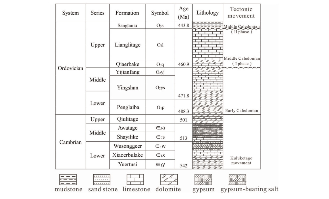
TABLE 1. Ordovician stratigraphic column of the study area.
The periods of reservoir formation are coinciding with the tectonic movement periods experienced by the basin, and the hydrocarbon distribution is closely related to fault activities. As one of the important fault types inside the craton basin, the strike-slip faults affect the reformation of carbonate rocks that leads to the development of a broken breccia zone and an induced fracture zone and the formation of aggregated fractures, cavities, and caves distributed along the fault plane. More importantly, it provides longitudinal pathways for upward and downward fluids and forms high-quality reservoir space for the dissolution and reformation of the carbonate rock.
The strike-slip faults are mostly developed in the carbonate strata of the Tarim Basin. Due to the different properties of the diagenetic fluid inside the fault zone, two types of reservoirs were developed in the Ordovician carbonate rock in the deep horizon, namely, the fault-controlled fracture caverns (Figures 2A,B) and the fault-dissolved fracture caverns (Figures 2C–F). Among them, the reservoir space types of carbonate reservoirs from the Tabei uplift to the southern Tahe area and Shuntuoguole area are dominated by large caves along the fault plane of major faults in the deep horizons, which are typical reservoirs of the fault-controlled fracture caverns (Deng, et al., 2018; Qi, 2020). In the core samples containing hydrothermal minerals such as the giant-crystal calcite and the authigenic quartz from multiple wells along the strike-slip fault zone in the northern slope of the Tazhong Uplift, there is dissolution along the fractures, and hydrothermal mineral filling or metasomatic bedrock can be observed (Figures 2C,D). This indicates an upward hydrothermal dissolution and reformation along the strike-slip faults. The reservoirs with well-developed dissolution pores and fractures in the lower part are classified as fault-dissolved fracture caverns (Li, et al., 2015). The characteristic of the fault-controlled fracture caverns is that the extensional breccia can be seen on the core picture (Figure 2A); meanwhile, intergranular fractures/pores and high-angle structural fractures are developed with a weak dissolution phenomenon on the core picture. The fault-dissolved fracture caverns, however, are developed by dissolution caused by meteoric freshwater or deep hydrothermal fluids. In addition, the net-shape strike-slip fault system is developed in the Tabei area of the Tarim Basin. Affected by the fault activities, the karstification of the Ordovician weathering crust is strong, with an increasing dissolution depth, forming a “lamination-like” distribution in the reservoir. The reservoir property is better along the faults, which embodies the control of the downward fluid by the strike-slip faults. The reservoir is dissolved by atmospheric freshwater, where the major reservoir spaces are dissolution pores, caves, and fractures (Figures 2E,F).
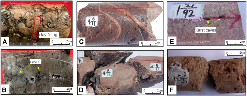
FIGURE 2. Core pictures show the characteristics of different types of reservoirs in Tarim Basin; (A,B) fractures and caves controlled by the strike-slip faults; clay filling can be seen in (A). Hydrothermal dissolved and modified reservoir controlled by the strike-slip faults can be seen in core pictures (C,D); (E,F) karst reservoir controlled by the strike-slip faults; karst caves can be seen in the core picture (E).
Three stages of karstification have been developed in the Tabei uplift (He, et al., 2019), the middle Caledonian, the early Hercynian, and the late Hercynian. During episode I of karstification in the middle Caledonian, the Middle-Lower Ordovician was exposed, where dissolved pores filled with grayish green argillaceous were developed in the top of the Yijiangfang Formation and large-scale caves along the faults, evidently controlled by the faults. In episode II of middle Caledonian, the uplifting of tectonic activity was more robust, leading to a greater difference in topographic elevation and better hydrodynamic conditions. However, surface water could only dissolve the early karst fracture caverns through faults and fractures because Middle-Lower Ordovician in most areas of the southern part in the Tabei uplift was covered by the formation with good water insulation. In the structural highs, the Lianglitage Formation and the Qiaerbake Formation of Upper Ordovician may have been completely eroded, which allowed the atmospheric fresh water to directly enter the Middle-Lower Ordovician for dissolution and reformation, where the karstification was strong. Due to the global ice age of the Late Ordovician-Early Silurian, the hydrodynamic and paleoclimate conditions were not favorable for karstification. In these areas covered by the Upper Ordovician, atmospheric fresh water primarily entered the Middle-Lower Ordovician along the fault. In the exposed area in the northern part, atmospheric fresh water directly dissolved and reformed the Middle-Lower Ordovician. The karstification of this stage is weak, while the faulting is strong (Figure 3).
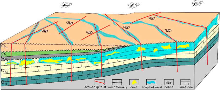
FIGURE 3. Model of reservoir reformation by the downstream fluid.
The early Hercynian tectonic activities have the characteristic of uplifting by stages, which enables the development of multiple karst systems. The karstification is constrained by the upper Ordovician mudstone and marlite aquifuge. The lithology of the upper Ordovician is complex. With thick mudstone existing in the Sangtamu Formation and the carbonate rocks in the Lianglitage Formation and the Qiaerbake Formation not being pure due to argillaceous, the development and extension length of fractures are limited. The fluid pathways can be easily filled by argillaceous, limiting the flow and dissolution along fractures. The fluid mainly dissolved and reformed the Middle-Lower Ordovician along the faults. The Middle-Lower Ordovician is a set of pure and tight carbonate rock, which is conducive for the development and extension of fractures and karstification.
There are also upstream fluid reformed reservoirs. The eruption of large-scale basalts in the Tarim Basin took place around 290–288 Ma (Yang, et al., 2007; Li, et al., 2008), mainly distributed in the western part of Tabei, Tazhong, and western regions of the basin. Several NE and NE strike-slip faults were developed in Shuntuoguole area, with high and steep occurrences. Places near the strike-slip fault were favorable for fracture development and deep fluid migration. At the end of the Late Ordovician, the underlying silicon-rich hydrothermal fluid of Cambrian rose along these NE strike-slip faults, and the fluid expanded and dissolved along the fractures. The reformation effect of the silicon-rich hydrothermal fluid on carbonate rocks was dissolution–metasomatism–cementation by acidic components on limestone, forming a porous silicified reservoir with diverse reservoir spaces (Figure 4).
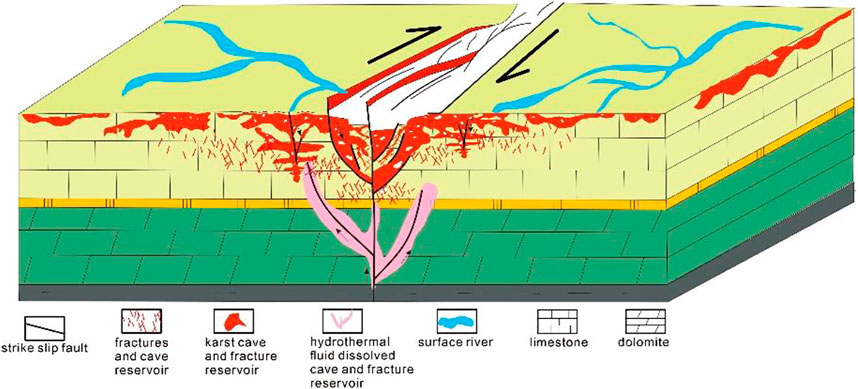
FIGURE 4. Reservoir model of different types controlled by strike-slip faults in the Tarim Basin.
In order to investigate the development characteristics of fault-controlled karst fracture caverns in carbonate reservoirs, underground high-density electrical logging was conducted in the karst of Neibanzhai Village, Maolan Nature Reserve, Libo County, Guizhou Province, China (Figure 5). Guizhou province, located in the southeast margin of the Yangtze Plate, is the most developed exposed karst area in China. There are three large NE-trending transpressional faults across the study area (Figure 5C), which belong to the Neocathaysian structure in terms of the structural system. Influenced by Yanshan movement and Indosinian movement, the main structures in the study area occurred, developed, and formed during this period (Liu, et al., 2010). The landform of this area is characterized by peak cluster depression (Figure 5B) mainly composed of Carboniferous carbonate rocks. The NE-trending Banzhai compression-torsion faults are developed in this area, where the main fault strike is about 35°, the dip ranges from 110° to 140°, the dip angle is larger than 60°, the length is more than 10 km, and the width of the fracture zone is between 10 and 40 m. The fault is filled with mylonite and breccia, with calcite vein and argillaceous filled in some parts. The breccia, composed of dolomitic limestone, varies in width. Affected by the Banzhai compression-torsion fault, fractures are relatively developed in the bedrock. There is karst development in the fracture zone, and micro-geomorphologies such as water-falling caves and karst caves are frequently observed in depressions.
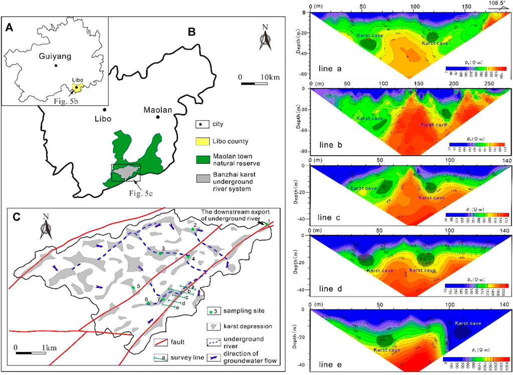
FIGURE 5. Location of the karst-developed areas in Banzhai village and the apparent resistivity quasi-section intersected by the Banzhai fault; the geographical location of Figure 5A is shown in Figure 1A; (A) geographic outline of Guiyang Province; (B) location and geographic outline of Libo county and Maolan natural reserve; (C) hydrogeological sketch map of the Banzhai underground River system, where there is the target area.
Five profile lines perpendicular to the Banzhai fault were surveyed using high-density resistivity logging, all of which were located in the flat valley of the fault zone, crossing the valley in the NW-SE direction (Figure 5C). The length of profile a is 200 m, that of profile b is 300 m, and those of profiles c and d are 150 m. The topography in the valley has little fluctuation. As shown in Figure 5, horizons in each profile are clear. The thickness of the overburden strata is between 0 and 8 m, showing low resistivity, where the apparent resistivity is mostly below 200 Ω m. The apparent resistivity of deep bedrock is high, mostly above 500 Ω m. The relatively low resistivity in the deep high resistivity can be inferred as karst anomaly caused by low-resistivity fillers such as water or muddy and sandy sediments in the karst. Based on the comprehensive analysis of the apparent resistivity quasi-section of each profile, combined with characterization of physical properties of rocks and previous learnings of this area, it is concluded that two sets of karst caves (karst conduits) were developed in the valley, located on both sides of the core of the fault zone. These two sets of karst caves are expected to be interconnected, constituting the underground river system of Banzhai.
Because water capable of erosion is one of enabling conditions for karst development, the evaluation of water erosivity is an important foundational work in karst research. The driving force of karstification is provided by the karst dynamic system consisting of three phases: the solid phase, the liquid phase, and the gas phase. When the CO2 gas phase in the system reaches chemical equilibrium with liquid and solid phases, nine kinds of ions or molecules would be found in liquid-phase water, and the chemical equilibrium involves three phases and nine equilibrium constants. Calcite saturation index SIc and partial pressure of carbon dioxide Pco2 are two important indicators in karst hydrology and geochemistry.
In this study, seven outcrop samples of groundwater were collected from the karst underground river basin area near the Banzhai fault in Libo County, Qiannan Prefecture, Guizhou Province, and the geological, structural, and hydrogeological characteristics of the underground river system were systematically analyzed.
The karst groundwater system in the karst underground river basin near the Banzhai fault is an epikarst system chemically driven by CO2. The major fault system has a significant controlling effect on karstification, which is demonstrated in the controlling effect the large compressional torsional faults and joint systems have on the distribution of depressions and major runoff channels. Hydrogeochemical characteristics are representative of this macro-control effect to a certain extent. The calcite saturation index of the main water points in the study area is between 0.007 and 0.217 (Table 2), less than 0.8, which has not met the favorable conditions for large-scale deposition of calcium carbonate, indicating that the system is still under the process of dissolution and migration of carbonate rocks, and karst is still developing in progress.
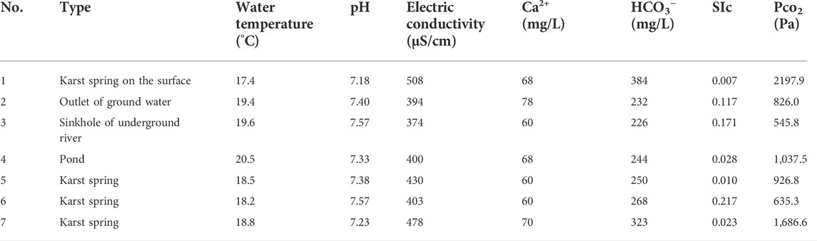
TABLE 2. Hydrochemical Parameters of Important Water Points of the Underground River Basin in Banzhai (The sampling positions are shown in Figure 5C).
The karst valley is controlled by the geochemical characteristics of surface water and the elevation differences in the landform during its development. In the upstream region of the Banzhai underground river basin, there is less surface water runoff, a low partial pressure of CO2, a high CaCO3 saturation index, and relatively slow karst development rates. In contrast, in the downstream flooded dam and the outlet of the underground river, there is more surface water runoff corresponding with a high partial pressure of CO2 and a low CaCO3 saturation index, resulting in a strong dissolution ability.
Faulting is foundational to modern karst development. Affected by regional stress, strike-slip faulting results in the development of a series of rhombus-shaped pull-apart regions around the fault zone. Under the atmospheric precipitation and karst reformation in the later stage, these pull-apart regions were further developed into rhombus-shaped karst valleys. The Genggan valley in Banzhai, Libo, Guizhou, is the most representative of this phenomenon. The lengths and widths of the karst valleys developed in the pull-apart areas generally range from hundreds of meters to 2–3 km. While the karst valley formed in the pull-apart area, the surrounding remains turned into mountains that are hundreds to thousands of meters high. In the karst valley formed under the regional major faults, the karst further expands along the fractures or jointed karst pore fissures, forming abundant karst pores, while karst caves of underground streams can be developed from multiple secondary faulting (Figure 6).
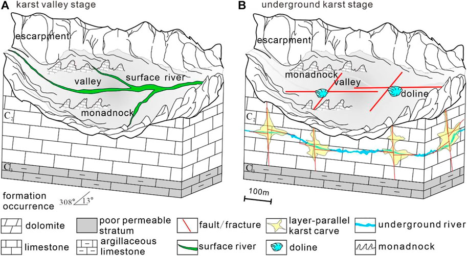
FIGURE 6. Development model of modern karst controlled by strike-slip faults; (A) karst valley stage, an extensional depression is developed at the junction of the two faults, and the river dissolves along the fracture; (B) underground karst stage, underground river is dissolved along the fault and karst depression is developed, typical geological phenomena such as monadnocks and dolines developed in karst depression.
Similar geological conditions for karst development can be found in the north slope of Tazhong toward Tabei area of the Tarim Basin. The NNE near-parallel fault system in the Tazhong Uplift and its northern slope and the NNE-NNW trending X-shaped faults in Tuoputai-Halahatang area of the Tabei Uplift provide the foundation for karstification. Multiple strike-slip faults were interconnected. From the Taibei Uplift to Shuntuoguole area, the Ordovician carbonate strata gradually transitioned from uplifted to buried. The development of the tectonic slope in Ordovician carbonate provided hydrodynamic conditions for karstification, which is consistent with the modern karst model. Controlled by fault connection and the tectonic slope in carbonate rock, atmospheric precipitation continues to percolate from the exposure area in the uplift of Tabei into the buried area of Shuntuoguole area in the south, forming a certain degree of karstification in Ordovician carbonate rocks in Shuntuoguole area, improving the reservoir.
In fact, many drilling data from the Tabei uplift to Shuntuoguole have confirmed the presence of kartisfication in Ordovician carbonate rocks. The middle-lower part of the Yijianfang Formation and the top of Yingshan Formation is dominated by intra-platform shoal by drilling data on the Shuntuoguole, where the lithology is mainly bright crystal algal limestone, with an average porosity of 3.4% and a permeability of 3.64×10⁻³ μm2. Thin core sections of the calcite showed no luminosity during cathodoluminescence experiments, and the main reservoir space is intragranular micro-pores of algal debris. It may be related to the quasi-syngenetic exposure and dissolution. The dissolution of atmospheric precipitation karst can be seen in all the carbonate rocks from multiple wells in the Yijianfang Formation and the Yingshan Formation (Figure 7). The bottom of the dissolved pores is karst residual material, and the top is filled with calcite. No luminosity can be obtained in cathodoluminescence experiments, indicating a result of the dissolution and reformation from atmospheric precipitation.

FIGURE 7. Fillings in Ordovician carbonate karst caves of Shuntuoguole area. (A) Bottom structure of atmospheric water karst; the bottom of the dissolved cave (upper corner on the right) is filled with dissolved residual, and the top of the dissolved pore (lower corner on the left of the pore) was filled by calcite, Shunbei area, O2yj. (B) Bottom structure for karst of atmospheric water; the dissolution residual is filled in dolomite particles at the bottom of dissolution pore (lower corner on the right), and calcite is filled at the top of the dissolution pore, Shunbei area, O1y. (C) Filled calcite at the top of the dissolved pore is not luminous, and the residue at the bottom is bright blue, as a clay debris residue, Shunbei area, O2yj. (D) Bottom structure for atmospheric karst; dissolved residuals are filled in dolomite particles at the bottom of dissolved pores (lower corner on the right) without luminosity, and calcite is filled in dissolved pores in at the top without luminosity, Shunbei area, O1y.
In addition, according to the modern karst model, nearly vertical karst fractures with meters wide can be developed via dissolution at the top of large karst fracture caves, where it is less likely be filled by debris. These vertical fractures can be well sustained, making it a great reservoir space outside the large karst caves. With the strike slip fault activities in Shuntuogol area of Tarim Basin, a large number of nearly vertical fracture systems can be developed in the Shuntuoguole area of the Tarim Basin following strike-slip faulting, producing abundant karst fractures along these fracture systems which are excellent reservoirs with significant opportunities for oil and gas accumulation.
The core issue for oil and gas enrichment in the fault zone of Shuntuoguole of the Tarim Basin is high-quality carbonate fracture caverns formed by strike-slip faults. The superposition of three stages of tectonic movements and the paleokarst in the middle Caledonian resulted in a large number of dissolved pores, large caves, and dissolved fractures in the middle-lower Ordovician strata, forming large-scale karst fracture-cavernous reservoirs that provide the basis for oil and gas accumulation. Large faults and regional unconformities provide advantageous migration pathways favorable for hydrocarbon accumulation (Figure 8). Inside the large strike-slip faults or at the intersections of conjugate faults where karst fracture-cavernous reservoirs are developed, oil and gas production is higher than that of nearby wells, indicating that these deep and large faults are the main pathways for upward migration of oil and gas. Three regional unconformities developed in the middle Caledonian, together with deep and large strike-slip faults and the Ordovician karst fracture-cavern system, constitute a three-dimensional oil and gas conduction system enabling oil and gas to migrate from deep source rocks to Ordovician karst fracture-cavernous reservoirs.
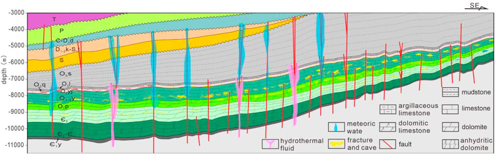
FIGURE 8. Patterns of hydrocarbon accumulation related to strike-slip faults in Tarim Basin.
The dissolution caused by the downstream fluid or karstification induced by the upstream fluid is common in Ordovician carbonate rocks in the strike-slip faults area of the Tarim Basin. It is also the most essential reservoir-forming mechanism, primarily developed in Tabei of the Tarim Basin with the characteristic of developing in multiple stages that can be roughly categorized into four. The first stage is the dissolution of atmospheric water or atmospheric water–seawater mix controlled by parasequences resulting from sea level changes, which is marked by intergranular dissolved pores and dissolved pores in dolomite of the Penglaiba Formation and dissolved pores in granular limestone of the Yijianfang Formation, the Lianglitage Formation, and the Sangtamu Formation. The second stage is the dissolution of atmospheric water controlled by the unconformities in the middle Caledonian, marked by the dissolved pores or dissolved fracture caverns in the upper part of the Yijianfang Formation and the upper part of the Lianglitage Formation. The third stage is the dissolution of atmospheric water controlled by the angle unconformity of the early Hercynian. However, this stage of karst in southern Tahe is not the leading effect like the main area because Shuntuoguole area had been located below the phreatic surface. It plays a secondary role and is characterized by fracture-controlled karst locally. The fourth stage is the hydrothermal karstification related to hydrothermal activities after the Hercynian. Most strike-slip faults in Shuntuoguole area were faulted through the bedrock, providing a pathway for upward hydrothermal fluids. However, their contribution to the reservoir is limited due to the fact that the dissolution of hydrothermal fluids is always accompanied by metasomatism and cementation. Among these four stages, the first two, especially the second stage of middle Caledonian, have the greatest effects on the development of the Ordovician carbonate reservoir in the southern Tahe area.
The strike-slip faults in the study area are well developed, where the fault network is composed of small dissolved collapse faults and major faults. The major faults can be faulted downward through Cambrian or deeper and upward to Carboniferous, which very well connects the Cambrian-Ordovician source rocks and the Ordovician reservoir vertically. The analysis of fault activities reveals that these faults can be active for multi-stages, from the early Hercynian to the period after the end of Hercynian. They are compatible with a large amount of multi-stage oil and gas generation by forming an effective vertical migration system. The development of vertical structural fractures in multi-stages and high-angle oblique horizons improves the condition of the vertical migration system. Based on the core observations, it can be revealed that the tectonic fractures in the Ordovician carbonate profile in the area are characterized by vertical and high-angle oblique planes, regardless of whether calcite is fully filled or partially filled in the structural fractures. The comprehensive study of the petrological relationship and geochemical characteristics show that these are the result of tectonic stress after stages of the Caledonian, the early Hercynian, the Indosinian-Yanshanian, and the Himalayan. These fractured calcites are rich in hydrocarbon inclusions or have hydrocarbons of several stages preserved in effective fractures, which validates the important role these fractures play in the hydrocarbon migration in practice via improving the conditions to complement the faults in constituting a complete vertical conduction system.
Second, the development of multi-stages of unconformities makes a superior lateral conduction condition. The top of the Yijianfang Formation is a parallel unconformity formed in stage I of the Middle Ordovician, and the top of the Lianglitage Formation is a parallel unconformity formed in stage II of the Middle Ordovician, both of which play an important role not only in the formation of the Ordovician reservoir but also in the entrapment, migration, and accumulation of oil and gas in the Ordovician enabling the oil and gas lateral conduction system to be effectively developed. Carbonate rocks nearby the underneath of the unconformity become good reservoirs after leaching and corrosion by atmospheric water, forming the lateral conduction system for oil and gas. Karstification and reformation from atmospheric water in the Hercynian was robust, characterized by the development of large cave systems horizontally or nearly horizontally. On one hand, they created excellent reservoir conditions; on the other hand, they also formed a good lateral conduction system.
(1) Under the combined action from strike-slip faulting and the underground fluid, the strike-slip faults not only affect the upstream hydrothermal dissolution and reformation but also conduct the dissolution of the downstream fluid by atmospheric freshwater, resulting in the development of fault-controlled fractured-cavernous reservoirs, fault-dissolved fracture-cavernous reservoirs, or fault-controlled fracture-porous reservoirs in dense carbonate rocks and the development of dissolved pores, caves, and fractures.
(2) According to the modern karst model, the network fault system formed by strike-slip faults is conducive to the development of karst pores, while the tectonic slope provides hydrodynamic conditions for karstification. Karst fractures developed by dissolution along fractures can be formed in the top of the caves, which are less likely to be filled by debris, making it an important reservoir space outside the large karst caves.
(3) The quality of reservoirs formed by the downstream fluid in carbonate rocks is better than that of the upstream hydrothermal fluid, which has a relatively positive impact on hydrocarbon accumulation. The Ordovician karst fracture-cavernous system, unconformities, and strike-slip faults together constitute a three-dimensional oil and gas conduction system that provides conditions for oil and gas migration and accumulation from the deep source rock to the Ordovician karst reservoir.
The original contributions presented in the study are included in the article/supplementary material; further inquiries can be directed to the corresponding author.
FN: conceptualization, methodology, investigation, writing—Original Draft. HL: supervision; CZ: formal analysis; JY: investigation; PL: geophysical research, HS: investigation, data curation.
This research was funded by the National Natural Science Foundation of China (Nos. 41972128, 41872161), with additional support from the Strategic Priority Research Program of the Chinese Academy of Sciences (Grant No. XDA14010402).
The authors declare that the research was conducted in the absence of any commercial or financial relationships that could be construed as a potential conflict of interest.
All claims expressed in this article are solely those of the authors and do not necessarily represent those of their affiliated organizations or those of the publisher, the editors, and the reviewers. Any product that may be evaluated in this article or claim that may be made by its manufacturer is not guaranteed or endorsed by the publisher.
Deng, S., Li, H., Zhang, Z., Wu, X., and Zhang, J. (2018). Characteristics of differential activities in major strike-slip fault zones and their control on hydrocarbon enrichment in Shunbei area and its surroundings, Tarim Basin. Oil Gas. Geol. 39 (5), 38–48. (in Chinese with English abstract). doi:10.11743/ogg20180503
Deng, S., Liu, Y., Liu, J., Han, J., Wang, B., and Zhao, R. (2021a). Structural styles and evolution models of intracratonic strike-slip faults and the implications for reservoir exploration and appraisal: A case study of the Shunbei area, Tarim basin. Geotect. Metallogenia 45 (6), 1111–1126. doi:10.16539/j.ddgzyckx.2020.05.015 (in Chinese with English abstract)
Deng, S., Zhao, R., Kong, Q., Li, Y., and Li, B. (2021b). Two distinct strike-slip fault networks in the Shunbei area and its surroundings, Tarim Basin: Hydrocarbon accumulation, distribution and controlling factors. Am. Assoc. Pet. Geol. Bull. 106 (1), 77–102. doi:10.1306/07202119113
Ding, Z., Wang, R., Chen, F., Yang, J., Zhu, Z., Yang, Z., et al. (2020). Origin, hydrocarbon accumulation and oil-gas enrichment of fault-karst carbonate reservoirs: A case study of ordovician carbonate reservoirs in south Tahe area of halahatang oilfield. Tarim Basin. Pet. Explor. Dev. 47 (2), 78–88. doi:10.11698/PED.2020.02.07 (in Chinese with English abstract)
Gehrels, G. E., Yin, A., and Wang, X. (2003). Magmatic history of the northeastern Tibetan Plateau. J. Geophys. Res. 108 (B9), 2423. doi:10.1029/2002jb001876
Gu, Y., Huang, J., Jia, C., Shao, Z., Sun, Y., and Lu, Q. (2020). Research progress on marine oil and gas accumulation in Tarim Basin. Pet. Geol. Experi. 42 (1), 1–12. doi:10.11781/sysydz202001001 (in Chinese with English abstract)
Hacker, B. R., Ratschbacher, L., Webb, L., McWilliams, M. O., Ireland, T., Calvert, A., et al. (2000). Exhumation of ultrahigh‐pressure continental crust in east central China: Late Triassic‐Early Jurassic tectonic unroofing. J. Geophys. Res. 105 (B6), 13339–13364. doi:10.1029/2000jb900039
Han, J., Su, Z., Chen, L., Guo, D., Zhang, Y., Ji, Y., et al. (2019). Reservoir-controlling and accumulation-controlling of strike-slip faults and exploration potential in the platform of Tarim Basin. Acta Pet. Sin. 40 (11), 1296–1310. doi:10.1016/j.marpetgeo.2017.08.033 (in Chinese with English abstract)
He, D., Zhou, X., Zhang, C., Yang, W., and Shi, X. (2006). Characteristics of geologic framework of multicycle superimposed basin in Tarim basin. China Pet. Explor. 11 (1), 316–417. (in Chinese with English abstract).
He, F., Qi, R., Wang, F., Deng, J., Cheng, L., and Hu, T. (2021). Tectonic genesis of triassic yanchang formation valley systems, southern Ordos Basin. Oil Gas. Geol. 42 (05), 1056–1062. doi:10.11743/ogg20210504 (in Chinese with English abstract)
He, Z., Yun, L., You, D., Peng, S., Zhang, H., Wang, K., et al. (2019). Genesis and distribution prediction of the ultra-deep carbonate reservoirs in the transitional zone between the Awati and Manjiaer depressions, Tarim Basin. Earth Sci. Front. 26 (1), 13–21. doi:10.13745/j.esf.sf.2018.12.20 (in Chinese with English abstract)
Jia, C., Li, B., Zhang, X., and Li, C. (2007). Formation and evolution of the Chinese marine basins. Chin. Sci. Bull. 52 (S1), 1–11. (in Chinese). doi:10.1007/s11434-007-6012-x
Li, S., Zhao, S., Liu, X., Cao, H., Yu, S., Li, X., et al. (2018). Closure of the proto-Tethys Ocean and early paleozoic amalgamation of microcontinental blocks in east asia. Earth. Sci. Rev. 186, 37–75. doi:10.1016/j.earscirev.2017.01.011
Li, Y., Ye, N., Yuan, X., Huang, Q., Su, B., and Zhou, R. (2015). Geological and geochemical characteristics of silicified hydrothermal fluids in Well Shunnan 4, Tarim Basin. Oil Gas. Geol. 36 (06), 934–944. doi:10.11743/ogg20150608 (in Chinese with English abstract)
Li, Z., Yang, S., Chen, H., Yu, X., and Langmuir, C. H. (2008). Chronology and geochemistry of taxdnan basalts from the Tarim Basin: Evidence for permian plume magmatism. Acta Petrol. Sin. 24 (5), 959–970. (in Chinese with English abstract).
Liu, L. P., Li, S. Z., Dai, L. M., Wang, Y., J., Liu, B., Jin, C., et al. (2010). Structural characteristics and evolution in Guizhou province, west of xuefeng mountain. Chin. J. Geol. 45 (1), 228–242. (in Chinese with English abstract).
Lu, X., Wang, Y., Tian, F., Li, X., Yang, D., Li, T., et al. (2017). New insights into the carbonate karstic fault system and reservoir formation in the Southern Tahe area of the Tarim Basin. Mar. Pet. Geol. 86, 587–605. doi:10.1016/j.marpetgeo.2017.06.023
Ma, D., Wang, Z., Duan, S., Gao, J., Jiang, Q., Jiang, H., et al. (2018). Strike-slip faults and their significance for hydrocarbon accumulation in Gaoshiti-Moxi area, Sichuan Basin, SW China. Petroleum Explor. Dev. 45 (5), 851–861. (in Chinese with English abstract). doi:10.1016/s1876-3804(18)30088-0
Ma, D., Wu, G., Zhu, Y., Tao, X., Chen, L., Li, P., et al. (2019). Segmentation characteristics of deep strike slip faults in the Tarim basin and its control on hydrocarbon enrichment: Taking the ordovician strike slip fault in the halahatang oilfield in the Tabei area as an example. Earth Sci. Front. 26 (1), 225–237. doi:10.13745/j.esf.sf.2019.1.10 (in Chinese with English abstract)
Ma, Y., He, Z., Zhao, P., Zhu, H., Han, J., You, D., et al. (2019). A new progress in formation mechanism of deep and ultra-deep carbonate reservoir. Acta Pet. Sin. 40 (12), 1415–1425. doi:10.7623/syxb201912001 (in Chinese with English abstract)
Ma, Y., Li, M., Cai, X., Xu, X., Hu, D., Qu, S., et al. (2020). Mechanisms and exploitation of deep marine petroleum accumulations in China: Advances, technological bottlenecks and basic scientific problems. Oil Gas. Geol. 41 (04), 655683–656672. doi:10.11743/ogg20200401 (in Chinese with English abstract)
Mattauer, M., Matte, P., Malavieille, J., Tapponnier, P., Maluski, H., Qin, X. Z., et al. (1985). Tectonics of the qinling belt: Build-up and evolution of eastern asia. Nature 317 (6037), 496–500. doi:10.1038/317496a0
Mattern, F., and Schneider, W. (2000). Suturing of the proto- and paleo-tethys oceans in the western Kunlun (xinjiang, China). J. Asian Earth Sci. 18 (6), 637–650. doi:10.1016/s1367-9120(00)00011-0
Peacock, D. C. P. (1991). Displacements and segment linkage in strike-slip fault zones. J. Struct. Geol. 13 (9), 1025–1035. doi:10.1016/0191-8141(91)90054-m
Qi, L. (2020). Characteristics and inspiration of ultra-deep fault-karst reservoir in the Shunbei area of the Tarim Basin. China Pet. Explor. 25 (1), 102–111. (in Chinese with English abstract).
Qiu, H., Deng, S., Cao, Z., Yin, T., and Zhang, Z. (2019). The evolution of the complex anticlinal belt with crosscutting strike-slip faults in the central Tarim Basin, NW China. Tectonics 38, 2087–2113. doi:10.1029/2018tc005229
Ratschbacher, L., Hacker, B. R., Calvert, A., Webb, L. E., and Hu, J. (2003). Tectonics of the qinling (Central China): Tectonostratigraphy, geochronology, and deformation history. Tectonophysics 366 (1–2), 1–53. doi:10.1016/S0040-1951(03)00053-2
Sobel, E. R., and Arnaud, N. (1999). A possible middle Paleozoic suture in the Altyn Tagh, NW China. Tectonics 18 (1), 64–74. doi:10.1029/1998tc900023
Wu, C., Yin, A., Zuza, A. V., Zhang, J., Liu, W., and Ding, L. (2016). Pre-Cenozoic geologic history of the central and northern Tibetan Plateau and the role of Wilson cycles in constructing the Tethyan orogenic system. Lithosphere 8 (3), 254–292. doi:10.1130/l494.1
Wu, G., Ma, B., Han, J., Guan, B., Chen, X., Yang, P., et al. (2021). Origin and growth mechanisms of strike-slip faults in the central Tarim cratonic basin, NW China. Petroleum Explor. Dev. 48 (3), 595–607. (in Chinese with English abstract). doi:10.1016/s1876-3804(21)60048-4
Wu, G., Zhang, T., Zhu, Y., Wan, X., and Xiong, C. (2020). The architecture, distribution and growth of carbonate fault damage zone. Chin. J. Geol. 55 (1), 68–80. (in Chinese with English abstract).
Xiao, W. J., Windley, B., Hao, J., and Zhai, M. G. (2003). Accretion leading to collision and the permian solonker suture, inner Mongolia, China: Termination of the central asian orogenic belt. Tectonics 22, 1069–1089. doi:10.1029/2002tc001484
Xiao, W., Windley, B. F., Sun, S., Li, J., Huang, B., Han, C., et al. (2015). A tale of amalgamation of three permo-triassic collage systems in central asia: Oroclines, sutures, and terminal accretion. Annu. Rev. Earth Planet. Sci. 43 (1), 477–507. doi:10.1146/annurev-earth-060614-105254
Yang, H., Deng, X., Zhang, Y., Xie, Z., Li, Y., Li, S., et al. (2020). Great discovery and its significance of exploration for Ordovician ultra-deep fault-controlled carbonate reservoirs of Well Manshen 1 in Tarim Basin. China Pet. Explor. 25 (3), 17–27. (in Chinese with English abstract).
Yang, S., Li, Z., Chen, H., Santosh, M., and Yu, X. (2007). Permian bimodal dyke of Tarim Basin, NW China: Geochemical characteristics and tectonic implications. Gondwana Res. 12 (1), 113–120. doi:10.1016/j.gr.2006.10.018
Yin, A., Manning, C. E., Lovera, O., Menold, C. A., Chen, X. H., and Gehrels, G. E. (2007). Early Paleozoic tectonic and thermomechanical evolution of ultrahigh‐pressure (UHP) metamorphic rocks in the northern Tibetan Plateau, Northwest China. Int. Geol. Rev. 49 (8), 681–716. doi:10.2747/0020-6814.49.8.681
Zhu, G., Sun, C., Zhao, B., Li, T., Chen, Z., Yang, H., et al. (2020). Formation, evaluation technology and preservation lower limit of ultra-deep ancient fracture-cavity carbonate reservoirs below 7000 m. Nat. Gas. Geosci. 31 (5), 5–19. doi:10.11764/j.issn.1672-1926.2020.04.013 (in Chinese with English abstract)
Zhu, G., Yang, H., Zhu, Y., Gu, L., Lu, Yu., Su, J., et al. (2011). Study on petroleum geological characteristics and accumulation of carbonate reservoirs in Hanilcatam area, Tarim basin. Acta petro. Sin. 27 (03), 827–844. (in Chinese with English abstract).
Keywords: strike-slip (fault), characteristics of reservoirs, modern karst environment, development model, carbonate layer, Tarim Basin
Citation: Ning F, Lin H, Zhou C, Yun J, Li P and Song H (2022) Characteristics of strike-slip fault-related reservoirs and the significance for hydrocarbon accumulation in the central Tarim Basin: Insights from the modern karst model. Front. Earth Sci. 10:987020. doi: 10.3389/feart.2022.987020
Received: 05 July 2022; Accepted: 04 August 2022;
Published: 06 September 2022.
Edited by:
Deyu Gong, Research Institute of Petroleum Exploration and Development (RIPED), ChinaReviewed by:
Xiaoqun Yang, Institute of Geology and Geophysics (CAS), ChinaCopyright © 2022 Ning, Lin, Zhou, Yun, Li and Song. This is an open-access article distributed under the terms of the Creative Commons Attribution License (CC BY). The use, distribution or reproduction in other forums is permitted, provided the original author(s) and the copyright owner(s) are credited and that the original publication in this journal is cited, in accordance with accepted academic practice. No use, distribution or reproduction is permitted which does not comply with these terms.
*Correspondence: Fei Ning, bmluZ2ZlaTAzN0BhbGl5dW4uY29t
Disclaimer: All claims expressed in this article are solely those of the authors and do not necessarily represent those of their affiliated organizations, or those of the publisher, the editors and the reviewers. Any product that may be evaluated in this article or claim that may be made by its manufacturer is not guaranteed or endorsed by the publisher.
Research integrity at Frontiers
Learn more about the work of our research integrity team to safeguard the quality of each article we publish.