 Ahmed Karmaoui1*
 Abdelkrim Ben Salem2
 Samir El Jaafari3
 Hassan Chaachouay4Adil Moumane5
 Lhoussain Hajji6
- 1Bioactives, Health and Environment Laboratory, Epigenetics team (Moulay Ismail University, Meknès), Faculty of Science and Techniques, Moroccan Center for Culture and Science, Errachidia, Morocco
- 2Research Center Plant and Microbial Biotechnologies, Biodiversity and Environment (BioBio), Faculty of Sciences, Mohammed V University in Rabat and Moroccan Center for Culture and Sciences (SCCS), Rabat, Morocco
- 3Cluster of Competency on Health and Environment, Moulay Ismail University of Meknes, Meknes, Morocco
- 4Bioactives, Health and Environment Laboratory, Epigenetics, Health and Environment Unit, Faculty of Science and Techniques, Errachidia, Moulay Ismail University, Meknes, Morocco
- 5Department of Geography, Ibn Tofail University, Kenitra, Morocco
- 6Bioactives, Health and Environmental Laboratory, Epigenetics, Moulay Ismail University, Meknes, Morocco
The study investigates the land use and land cover (LULC) in Errachidia province (Pre-Saharan of Morocco) in the period 2005–2020. To this end, remote sensing (RS) tools such as LULC, the normalized difference vegetation index (NDVI), the normalized difference water index (NDWI), the Enhanced Vegetation Index (EVI), Gravity Recovery and Climate Experiment (GRACE) satellite data, and precipitations were processed and combined. The monitoring of LULC over this period reveals different changes in this area. Generally, for water bodies, two trends can be observed, an increasing trend since 2006 and a decreasing trend from 2011 to the present. However, an increasing trend was recorded for the urban-and-built-up-lands and the grasslands categories. NDVI, NDWI, and EVI showed three major peaks recorded in the same periods (in 2007, 2009, and 2015). In terms of water storage, three phases were found. The first depicted the lowest groundwater quantities with a decreasing trend, which corresponds to a period of drought and/or human pressure. The second phase, the most important that recorded the greatest storage of water while the third phase corresponds to low storage with a decreasing trend. LULC of croplands reveals a slightly increasing trend from 2012 to 2020, which shows an orientation to an extension of crops mainly of date palm encouraged by government programs. A strong correlation between the seasonal NDVI and water storage using GRACE-Data for the period was found. In the end, recommendations on the adaptation to CC were proposed. The findings demonstrate that RS techniques are useful tools to detect hydrological droughts, observe, and conserve land resources. In arid areas such as Errachidia, the solution lies in rationalizing the use of water resources protecting them from uncontrolled anthropogenic events, which may alleviate the pressure. To support local sustainable development, environmental scientists and decision-makers may use the outputs of this study.
Introduction
Globally, climate change (CC) and extreme events such as droughts are expected to affect both the terrestrial and aquatic productive ecosystems. Many recent studies show the impact of CC and/or drought on terrestrial and aquatic ecosystems (Häder and Barnes, 2019), mainly water surface and groundwater (Wang et al., 2022) in arid and semi-arid zones (Zhang et al., 2021). Drought is a devastating and costly disaster that continuously affects various climatic zones in the world (Hoque et al., 2020). It poses serious economic and ecological concerns (Xie and Fan, 2021). It has a considerable effect on socio-ecological systems in the entire world, particularly in arid and semi-arid areas (Karmaoui et al., 2021). The vulnerability of arid regions areas is progressively increasing, which affects the wellbeing of a large population. In a recent study, Spinoni et al., 2021 demonstrated how will the increase of arid areas affect croplands, pastures, forests (land-use), and people in the 21st century. In this study, the authors showed that at 1.5°C warmings, around 1.4% of global land is expected to convert to arid and at 4°C to 4.5%. Consequently, some associated problems such as migration, land degradation (Hermans and McLeman, 2021), and waterbody such as river issues (Noorisameleh et al., 2020) are emerging. The hydrologic balances and input supplies are directly affected by CC and droughts. This may constitute a serious impact on crop and livestock production. The impact of anthropogenic factors is also omnipresent that may be seen in the reduction of water storage and natural vegetation cover particularly, in arid and semi-arid regions.
A variety of methods and techniques were developed and tested to assess the state of these natural resources and the impact of CC, extreme events, and anthropogenic pressure including geospatial techniques (GSTs) such as remote sensing (RS). GSTs are used to assess groundwater (Moumane et al., 2021), water erosion (soil elimination by water) (Ben Salem et al., 2019; Ougougdal et al., 2020), seasonal crop estimates (Gonzalez-Gonzalez and Guertin, 2021), and drought vulnerability (Hoque et al., 2020). From a methodological point of view, the techniques used to explore the impact of CC and drought are numerous. LULC is a relevant example used frequently in ecosystem monitoring and management. To alleviate drought risks, Fan et al., 2021 explored the importance of spatial heterogeneity in land planning optimization. However, Yifru et al., 2021 evaluate the effect of LULC on water yield and groundwater recharge based on an integrated model. The NDVI tool is used also to assess the impact of drought and CC. Nanzad et al., 2019 used the NDVI anomaly to monitor drought and explore the association with climatic factors in the period 2000–2016. The authors found that NDVI anomaly varied according to LULC type; it is positively correlated with precipitation, and negatively linked to temperature. Otherwise, Xie and Fan, 2021 derived drought indices from Moderate Resolution Imaging Spectroradiometer (MODIS) vegetation indices (NDVI/EVI). NDWI is another interesting tool used also to study hydrological droughts (Noorisameleh et al., 2020). As is the case with NDVI, NDWI, and EVI for surface observations, underground can be also observed and studied using satellite observation such as the Grace Satellite data, one of the most extensively used tools to assess water storage among other applications. It gives monthly observations in water equivalent thickness. In this context, and to track seasonal and monthly drought, the study of Kumar et al. (2021) is a relevant example that used GRACE-based terrestrial water storage.
Connections between water, water storage, vegetation cover, land cover, and rainfall interact in a complex way and are not well studied in the oasis provinces in the pre-Sahara of Morocco. More particularly, the Errachidia province is understudied in terms of the application of LULC, NDVI, NDWI, and EVI. The most recent relevant study conducted in the area on water resources was about the hydrogeology of a complex aquifer system in the Upper Guir Basin near Errachidia (Abdelfadel et al., 2020). Using field measurements and descriptive statistics, this last study recommended the orientation to quantitative assessment of the water resources. The second study used a groundwater flow model to investigate the hydrogeological aspect of the oasis-system aquifer (Bouaamlat et al., 2016). This study reported that since the construction of Hassan Addakhil Dam (the largest dam in the province), piezometric heads have become dependent on annual changes rather than seasonal variations. According to this same study, these heads are influenced by recurrent droughts. A third study is focused on mechanisms of groundwater salinization in the Ziz Basin (Lgourna et al., 2015) reporting that this basin is completely dependent on groundwater and its salinization causes a reduction of the quality of drinking water and the local agricultural productivity in this region.
Research in this area reflects the scarcity of recent studies in the area that use the RS methods in a vulnerable area to CC and human pressure. Given this gap, research effort in this vulnerable area using more accurate and reliable methods such as RS techniques is required. Combined with Geographic Information Systems (GIS), these techniques present a decisive contribution to studying the environmental problems, disasters, resources, and land use (Essahlaoui and Abba, 2012).
The purpose of this study was to 1) explore the LULC changes in the province of Errachidia, 2) quantify the vegetation cover using different RS techniques in 2005–2020, and 3) estimate the terrestrial water storage in the province of Errachidia using RS techniques.
Materials and methods
Study area
The province of Errachidia or province of 330 days of sunshine has seven urban communes and 22 rural communes, with a population of 418,451 inhabitants (2014, the last official census), spread over an area of 27,037 km2 (HCP, 2019). Being located in the pre-Saharan zone of Morocco, this province was used as a study area due to its ecological importance since its oases were declared as a biosphere reserve by UNESCO in 2000 and because it supports the socio-economic status of a large population. However, the economy of the province is based mainly on agriculture, which makes the province very dependent on water resources and people’s lives are closely linked to climate. This is the case of the majority of oases on a global scale. As stated by Kabiri et al., 2012, in general, the situation of the oases is of significant importance, it is estimated that around 150 million people live in oases on a global scale and that have confronted livelihoods issues induced by environmental deterioration trends. This was reported also by Puy et al., 2018 in the context of the province of Errachidia advancing that desert oases constitute fragile agrarian zones, highly vulnerable to sand dunes induced by wind, clearly observed in the two oases of Merzouga and Hassilabiad that are surrounded by dunes.
Administratively, the province belongs to the southeastern region called Draa-Tafilalet, which is characterized by arid to semi-arid climates (El hafyani et al., 2019). It is crossed by two important Wadis Ziz and Ghriss that fed one of the biggest palm groves in the world (Eddouks et al., 2017) (Figure 1). From a geographical point of view, the altitudes change from more than 2000 m in the high Atlas Mountain (Northwestern) to approximately 400 m in the Saharan lowlands (Northwestern) (Figure 1). This variation in altitude contributes as well to a diversity of climate from north to south. Precipitations in the province are irregular in time and space from more than 250 mm in the highlands (High Atlas) to 130 mm near the city of Errachidia to less than 75 mm in the desert (Tafilalet plain) (HCP, 2018), which indicates hyper-arid climate conditions in Tafilalet Basin (Herzog et al., 2021). More precisely, the annual rainfall is 70 mm at Erfoud (the south) and 290 mm at Imilchil (the northern area) while the temperatures range from −5°C to 40°C (Ben Salem et al., 2011). The average annual population growth rate from 2004 to 2014 in the urban area is about 1.4% and −0.2% in the rural area (HCP, 2014). The urbanization rate in the province is about 46.4% the highest in the Draa-Tafilalet region (HCP, 2018). This province is exposed to many environmental issues such as floods (Karmaoui and Balica, 2021), prolonged droughts, dam silting, desertification (Mainguet et al., 2011), and a very important erosion rate (Ben Salem et al., 2019), and human pressure such as deforestation (Karmaoui et al., 2022).
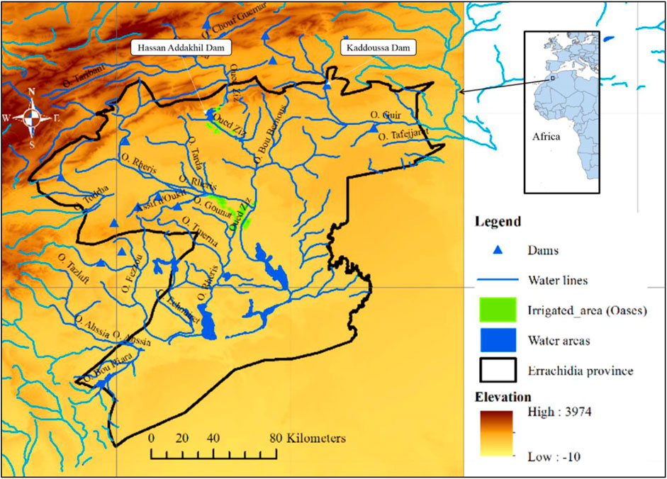
FIGURE 1. Localization of the study area, the Errachidia Province, Southeastern Morocco. SRTM elevation data offers Digital Elevation Model (DEM) at global scope with a resolution of 30 m. It was downloaded from NASA Earth Data Server (https://urs.earthdata.nasa.gov) using the QGIS software, version 3.1.15). SRTM Downloader Plugin was developed by Dr Horst Duester from Source pole AG.
Hydrologically, the province is associated with surface water derived from High Atlas Mountain and stored in Hassan Addakhil Dam, and from groundwater stored in Tafilalet. This reservoir with a capacity of 347 Mm3 provides the province with water for human and agriculture uses (HCP, 2019). It plays also a recharge role for the southern part of the Jurassic aquifer of the High Atlas (Ben-said et al., 2017). The groundwater of the Tafilalet is a considerable water resource (Bouaamlat et al., 2016) and the aquifer recharge is basically related to the high altitudes precipitations (Abdelfadel et al., 2020). Rainfall events in the High Atlas are also in the origin of frequent fluvial sediment driven towards the Tafilalt Basin (Herzog et al., 2021). In the most southern area, particularly in Erg Chebbi, groundwater is normally, accessed by “Khettaras,” traditional groundwater galleries, and shallow wells (García-Rodríguez et al., 2014).
The province includes several palm groves dominated by the date palm that offers a micro-humid climate supporting diversified agricultural production an essential pillar of local food security. Being the principal element of the oasis system, the date palm has considerable socioeconomic, and ecological roles including the important source of food for people and livestock (Sedra et al., 2015), the microclimate that supports several associated crops, and ecological equilibrium (Meddich et al., 2015). These palm groves are dependent on groundwater-fed by the hydrological regime of Wadis (Oueds) and rivers of the province (Bouaamlat et al., 2016). Any change in this regime induced by CC may influence agricultural production and then food security. Otherwise, this area faces many challenges such as soil and water salinization, desertification, and silting, mainly in the downstream area, Bayoud disease (a disease that affects the production of date palm), and the effect of droughts. For reference, Bayoud disease is caused by Fusarium oxysporum f. Sp. Albedinis (Foa), the first threat of date palm (Phoenix dactylifera L.) in Morocco (Essarioui and Sedra, 2017). This disease appeared and spread throughout all Moroccan oases, killing about 10 million palm trees (Sedra, 2012), which constitutes a real threat to the oasis system. Currently, the high-value varieties such as “Bouffegous” and “Mejhool” are highly sensitive and needs urgent management to fight against this disease (Bouhlali et al., 2020) and this may contribute to the protection of the entire oases.
Methodology
In the current study, we attempted to identify the potentials and areas of weakness in the province’s environment and emphasize the role of anthropogenic factors in accelerating vulnerability. It sheds light on the spatiotemporal changes that happened in the fifteen last years in land uses and water resources. The choice of the period 2005–2022 is based on the availability of GRACE satellite data that started from 2002 to currently.
Field data are rare or absent sometimes, inaccurate, or inaccessible for researchers in most cases, which suggests looking for alternative methods to collect data. Relevant data were obtained from prestigious databases, processed, and then used to reflect the general state and evolution of the resources and LULC of the province. This study considered land cover as the physical land kind including open water or forest while land use refers to human intervention on land (National Oceanic and Atmospheric Administration: https://oceanservice.noaa.gov/welcome.html).
Due the considerable area of the province (27,037 km2), a series of data sets from the MODIS Land Cover Type Product (MCD12Q1) that map global land cover of 500 m (spatial resolution) was used. The MCD12Q1 is generated based on supervised classification of MODIS reflectance data (Friedl et al., 2010) and the University of Maryland classification scheme (Hansen et al., 2000). To explore the droughts and anthropogenic impacts in the province of Errachidia, recognized indices such as NDVI, NDWI, EVI, LULC, water storage, and precipitations were estimated. The associated data of the images extracted using these indices were exported to the GIS tools to extract the values of changes of the LULC classes.
The first index is NDVI, it is a useful tool to create images of the vegetation cover (relative biomass). It can be used to explore drought (Xie and Fan, 2021), desertification (Kumar et al., 2020), and agricultural production (de la Casa et al., 2021). The Vegetation Index data was downloaded from Moderate Resolution Imaging Spectroradiometer (MODIS) satellite imagery from January 2005 to December 2020 (https://earthexplorer.usgs.gov/). The NDVI has been categorized into eight classes including urban and built-up lands, savannas, open shrublands, non-vegetated lands, grasslands, croplands, water bodies, and closed shrublands. Several studies have used NDVI to detect, assess, and monitor drought (Nanzad et al., 2019) and land degradation (Higginbottom and Symeonakis, 2014; Kumar et al., 2022). This index also estimates agricultural production (Roznik et al., 2022) and map fire risk (Michael et al., 2021). The NDVI calculation is based on the difference between the visible red band and the near-infrared band (Eq. 1).
where NIR refers to the reflection in the near-infrared spectrum and RED refers to reflection in the red range of the spectrum.
The values of NDVI vary in a scale ranging from −1.0 to 1.0 where negative values correspond to water, snow, and clouds, values near zero to bare soil, and higher values indicate dense vegetation.
To validate the values of the NDVI, an additional vegetation index, the EVI was used. It is frequently applied also to investigate drought (Xie and Fan, 2021). This Landsat index is used to quantify vegetation greenness like NDVI. It was proposed by Liu and Huete, 1995 with improved sensitivity to dense biomass regions. The estimations of the EVI index is based on Eq. 2. Layers used are of 1_km_monthly_EVI (MOD13A3.006) (Didan, 2015).
where NIR, surface reflectance in near-infrared; RED, and BLUE are surface reflectance in red and blue bands. L used to adjust for canopy background, C corresponds to the coefficients for atmospheric resistance. Several studies combined the use of NDWI and NDVI to enhance the difference between surface features (background) and water (Lu et al., 2011; Acharya et al., 2017). The normalized difference water index was proposed by Gao (Gao, 1995) to monitor the vegetation liquid water from space. It was used to study hydrological droughts (Noorisameleh et al., 2020) and for managing the soil moisture and the water bodies (Alsaady and Mohammed, 2021). The NDWI allows to determine moisture content in plants and soil using Eq. 3. Layers used are of 1_km_monthly reflectance (MOD13A3.006) (Didan, 2015).
where NIR reflects the near-infrared in the interval of 0.841–0.876 nm, and SWIR refers to short wave infrared.
A different RS technique was used to support the NDWI and validate the general trend of water resources in the study area. Otherwise, the agroecosystems of the province are based primarily on groundwater, which makes it crucial indicator of ecosystem dynamic in the province. The GRACE mission monitored the monthly dynamic of water storage to understand how this arid area is evolving. In fact, the Gravity observations of the Gravity Recovery and Climate Experiment Follow On (GRACE-FO) mission has been launched on 17 March 2002 to observe the Terrestrial water storage (TWS) changes that are linked to droughts (deficit of water) and flooding (surplus) (Girotto and Rodell, 2019). Data was extracted using the NASA GRACE Data Analysis Tool (DAT) where all data have been interpolated to a 1x1 degree grid. GRACE-FO satellites were used to estimate the equivalent water thickness (EWT) or water mass anomalies. The EWT refers to the total TWS changes from groundwater and aquifers, surface water such as lakes, reservoirs, rivers, snow, and soil moisture. Equivalent water thickness represents the total mass anomalies over land (sum of all water components in most cases—plus potentially non-hydrological signals that haven’t been removed such as large earthquakes) (Landerer and Cooley, 2021).
Remote sensing precipitation data: Data of the precipitation parameter was exported from the database POWER data access viewer through https://power.larc.nasa.gov/data-access-viewer/. Observed precipitations: Total annual rainfall and monthly rainfall.
The rainfall data used in this study constitutes the total annual rainfall and monthly rainfall of the four watersheds in which the province of Errachidia belongs to Guir, Ziz, Rheris, and Maider (GZRM), as well as those of the stations bordering them. This data was collected from 23 stations (Table 1) provided by the “Agence des Bassins Hydrauliques GZRM.” They are included between the hydrological year (1956/1957) and the year (2013/2014). In Morocco, the hydrological year begins on September 1 and ends on August 31 of the following year.
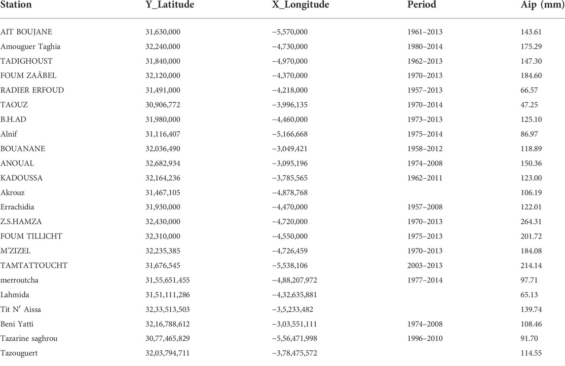
TABLE 1. Total annual rainfall and monthly rainfall. Source of data: archives of the “Agence des Bassins Hydrauliques GZRM.” AIP: Average interannual precipitation.
For the geographic Information System, QGIS 3.16. Software was used for the map creation and analysis of precipitations by data interpolation. The interpolation method used is Inverse Distance Weighting (IDW). The isohyets or lines (curves) of equal rainfall are plotted with the QGIS mapping software taking into account the geographical and topographic coordinates and the rainfall at the different rainfall stations.
The statistical analysis was performed using R software and XLSTAT to conduct the correlations (coefficient of determination R2, Bravais Pearson correlation R, p-value test, and correlogram.
For the RS techniques, data used in this study was downloaded using the application for Extracting and Exploring Analysis Ready Samples (AρρEEARS) (AρρEEARS, 2021). This AρρEEARS provides data values and the associated quality (For more information, refer to the link: https://appeears.earthdatacloud.nasa.gov/).
Results
Land use and land cover change and precipitation of the period 2005–2020
The findings show that the type of soil without vegetation (Non-vegetated lands) corresponds to the major part of the land use, which exceeds 90% of the total area of Errachidia. Compared to the spatial distribution of precipitation, this large bare area is strongly associated with the area with the lowest precipitations, which indicate that the province has high exposure to meteorological sources (Figure 2). The spatial analysis of precipitation has shown that the province is most exposed to drought and most vulnerable to anthropogenic pressure. The vegetation is concentrated in the mountainous areas in the northwestern where the annual precipitation exceeds 160 mm and in the oasis ecosystems through the province (the palm groves) (Figure 2).
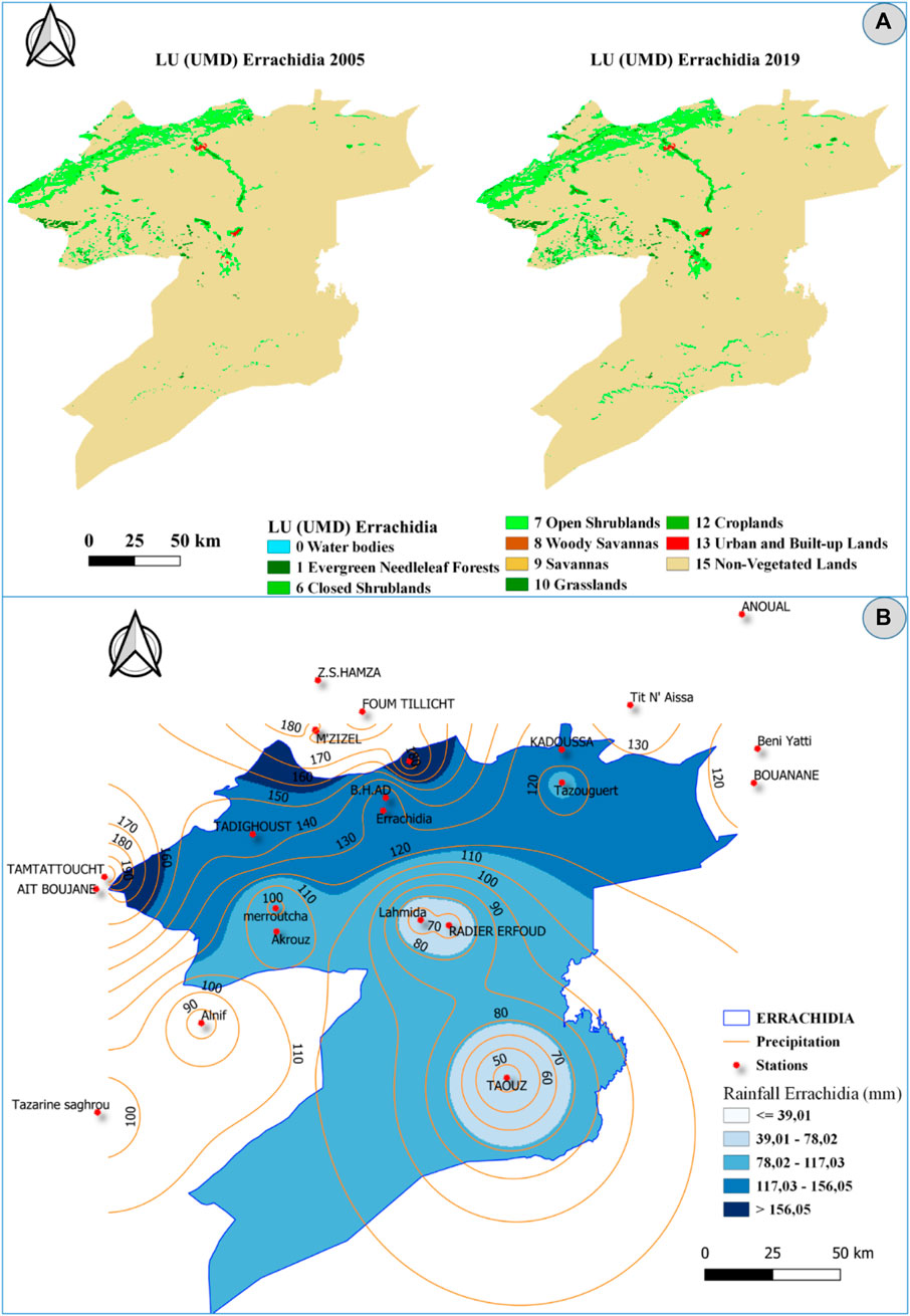
FIGURE 2. Characteristics of land use land cover and precipitation of Errachidia province. (A) LULC change and (B) precipitation of the studied period. Data of LULC: University of Maryland (UMD) (Michael et al., 2021); UMD scheme are provided at a 0.05° spatial resolution. The data source of precipitations: Archives of Agence des Bassins Hydrauliques of Guir, Ziz, Rheris, and Maider, see also Table 1.
The monitoring of LULC over the last 15 years reveals different changes in the province whether for urban and built-up lands, savannas, open shrublands, von-vegetated lands, grasslands, croplands, water bodies, and closed shrublands (Figure 3). The trends differ significantly from type to type. For surface water resources, generally, two trends can be observed, an increasing trend since 2006 and a decreasing trend from 2011 to the present. A similar evolution was also observed for closed shrublands, and savannas. Regarding the croplands, an increasing percentage was recorded from 2005 to 2009 and a decreasing trend from 2009 to 2012, then an increase again to the present. However, a positive trend in occupancy percentage was observed for the open shrublands category and continued growth for the urban and built-up lands, and the grasslands category. Concerning the type of soil without vegetation (Non-vegetated lands) followed a decreasing trend during the period 2005–2020.
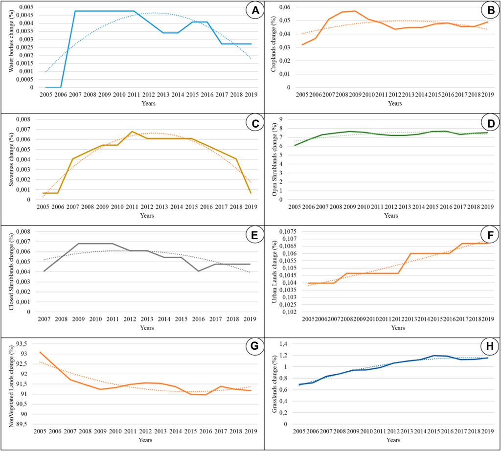
FIGURE 3. Land cover and land use percentage (%) change in the province of Errachidia (Southeastern Morocco) in the period between 2005 and 2020. (A) water bodies; (B) croplands; (C) savannas; (D) open shrublands; (E) closed shrublands; (F) urban lands; (G) non-vegetated lands; and h, grasslands. Dotted lines: polynomial trendline.
Coupling normalized difference vegetation index, normalized difference water index, enhanced vegetation index, water storage, and land use and land cover
The trend in vegetation cover was measured using the NDVI and EVI indices, which estimate the variation in greenery while the NDWI measured the vegetation liquid water over a period of time. The results show a similarity in the variation from 2005 to 2020 in this province (Figure 4) confirmed by a strong to very strong correlation using the statistical analysis. Indeed, three major peaks in the percentage of vegetation cover were recorded in the same periods. The first corresponds to an increase in 2007, the second in 2009, and the third, which is the most important in 2015. In general, the trend for the period 2005–2020 is negative with a marked fluctuation. Based on NDVI, NDWI, and EVI anomalies during the period from 2005 to 2020, the province experienced long periods of drought and the most affected years were 2005, 2006, 2010, 2011, 2012, 2019, and 2020. This indicates that these indices can help identify both the drought frequency and the wet years, periods with maximum values of greenery as showed in the years of 2007, 2009, and 2015 that coincide with maximum values of water bodies as depicted in Figure 4.
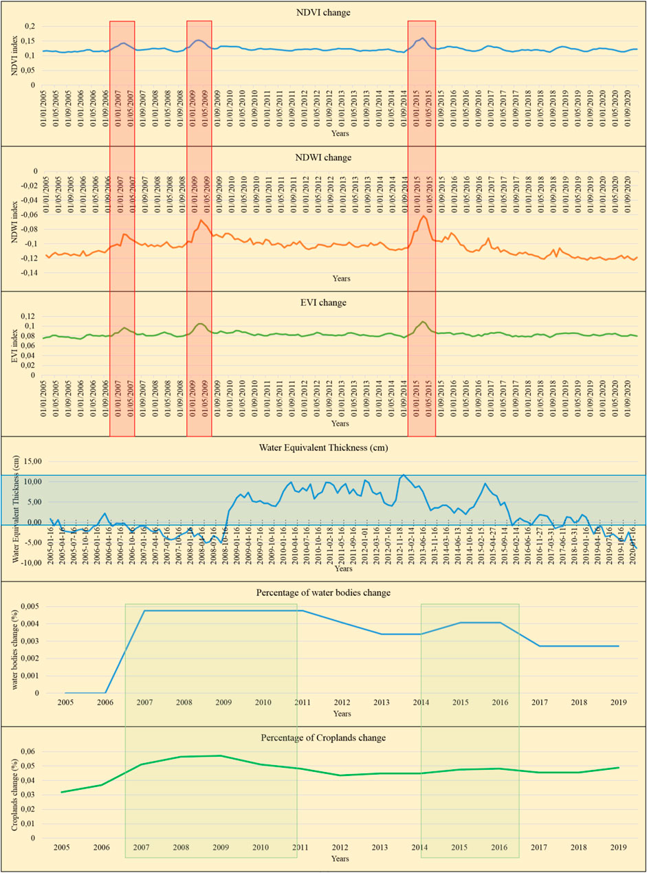
FIGURE 4. Comparison of water resources and vegetation cover coupling NDVI, NDWI, EVI, Water Equivalent Thickness, and LULC change (water bodies) in the province of Errachidia using remote sensing techniques.
In terms of water storage, the GRACE model shows a significant change in the province, which can be divided into three types of variations or phases (Figure 4). The first phase lasted 4 years (2005–2008), the second was from 2008 to 2015, and the third one lasted 5 years from 2015 to 2020. The first phase recorded the lowest quantities (water Eq.) with a decreasing trend, which corresponds to a period of drought and/or human pressure. The second phase, the most important and which recorded the greatest storage of water, which of course fluctuates significantly from year to year. It shows a good water supply and the big fluctuation may testify to big exploitation. The third phase corresponds to low storage with a decreasing trend, which may be explained by a low surface water supply and anthropogenic pressure on these resources. Statistically, the quantity of Water Eq. extracted using GRACE tool is moderate to strongly positive associated with the water quantity observed using NDWI (0.74) and the vegetation cover using EVI (0.68). The use of different RS methods to estimate the change may validate the applicability despite the very small areas of water and vegetation cover reported to the total areas of this desert province. This suggest investigating the LULC to smallest areas to cover the areas where the water and vegetation are localized such as the Valleys, the Wadi, and the palm groves.
The comparison of the percentages of water resources and cropland produced in the context of LULC reveals two parallel peaks with a slightly increasing trend (Figure 4). This shows an orientation to an extension of crops mainly of date palm and associated crops. The first peak is the largest and most widespread that lasted 5 years from 2007 to 2011 and the second peak lasted 2 years 2015–2016, noting also the start of a third peak for cropland from 2018.
The annual values from 2005 to 2020 (The average of the 12 months of each year) were compiled (Figure 5) and correlated using Pearson coefficient. The results revealed a moderate to strong correlation between water equivalents estimated using GRACE-data and EVI, NDVI, and NDWI values. This may indicate and validate the trends recorded.
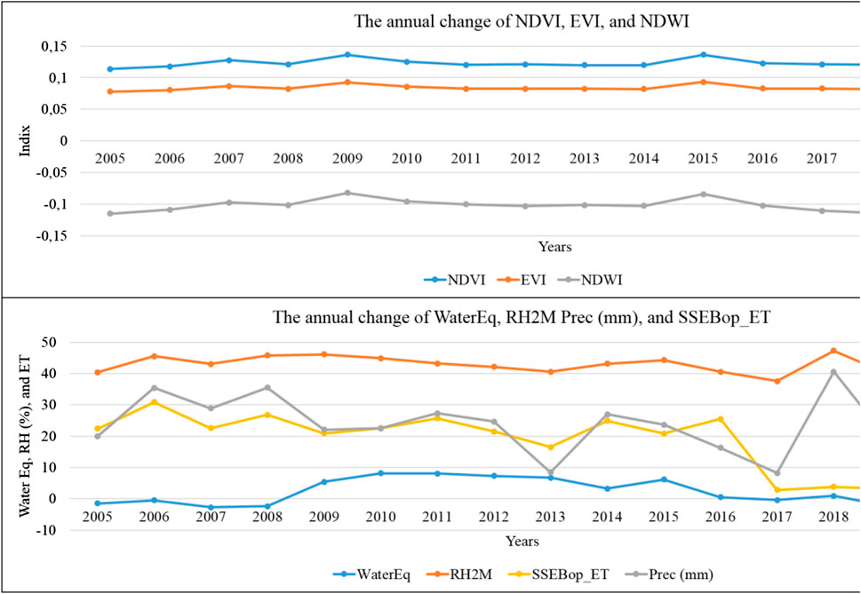
FIGURE 5. The annual changes from 2005 to 2020 (The average of the 12 months of each year).
Using Pearson Correlation Coefficient, the results revealed that NDVI is moderate to strong positive correlated with EVI (0.7265), NDWI (0.55), and relative humidity (0.697) while EVI is moderate to strong associate with NDWI (0.7521) and water equivalent (0.6834) and weak to relative humidity (0.498) and precipitation (0.484) (Table 2). However, NDWI is moderate to strong associated with water equivalent (0.7423), to relative humidity (0.639), and precipitation (0.5181). This indicates the importance of combining these indices to monitor the vegetation cover and water bodies.
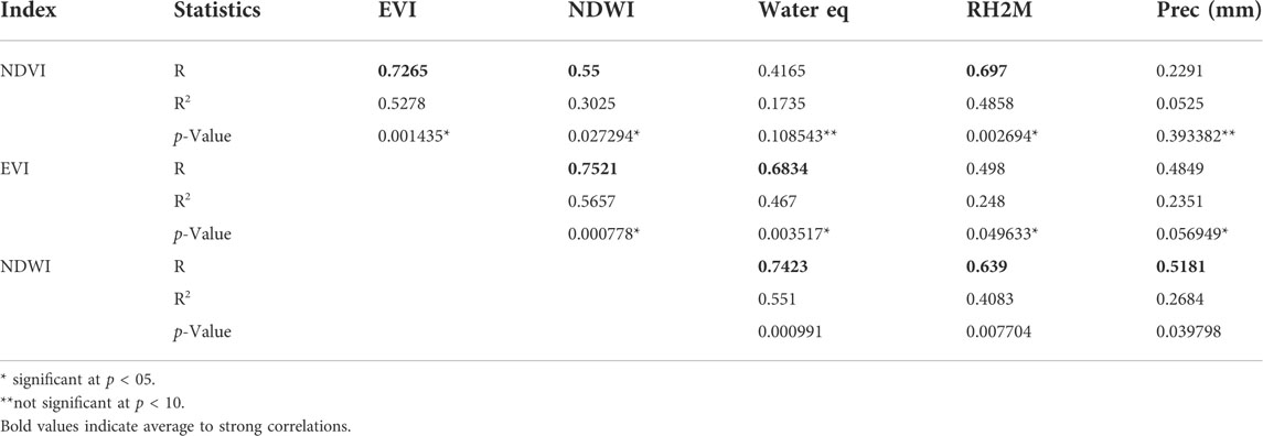
TABLE 2. Correlation between the RS variables using the Social Science Statistics calculator. R, Pearson Correlation Coefficient, and R2 is the coefficient of determination. Bold values refer to moderate to strong correlation.
To understand the seasonal behaviour of vegetation cover and groundwater storage in the province, data from NDVI and GRACE satellites for the period 2005–2020 were processed and coupled (Figure 6). The curve shows a very strong correlation (with R: 0.83 and R2: 0.69) of the two indicators with a biphasic form. The first peak is recorded in March in the heart of the spring season and the second peak is in December in winter.
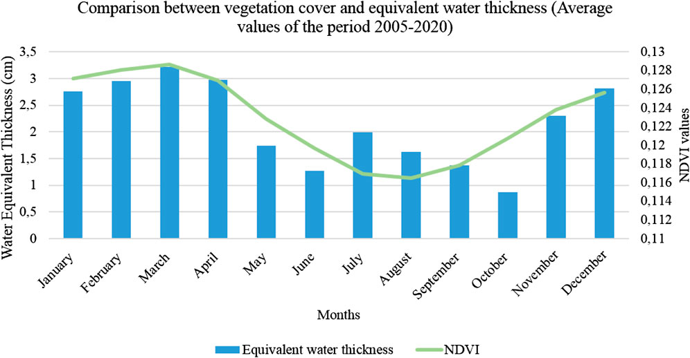
FIGURE 6. Change in the vegetation cover and the equivalent water thickness of Errachidia province in the period between 2005 and 2020 using remote sensing methods.
Discussion
In the context of CC, the precipitation is expected to change, which affects the vegetation conditions. The precipitations are rare in the areas “non-vegetated lands” mostly in the southeastern area of the province. Relative dense vegetation cover is correlated spatially with high precipitations in the northwest area, in High Atlas Mountains that exceed 160 mm. However, vegetation cover is observed also in areas with low precipitation, particularly in oases ecosystems. Certainly, the oases are present along with the province in areas with low precipitation but this distribution is due to the Hassan Addakhil Dam releases and the groundwater resources. In recent years, due to the drought observed (low inflows) in the Ziz watershed, the Hassan Addakhil dam has decreased continuously (Ben-said et al., 2017). An additional issue related to this dam is the siltation due to soil erosion. Ben Salem et al., 2011 advanced that if the high sediment transport rates in rivers are uninterrupted, the dam will not be completely functional for irrigation on the horizon of 2030. Otherwise, Manaouch et al., 2020 reported that with an initial capacity of 380 Mm3 in 1973, this dam experienced a siltation rate of 1.47 Mm3/year. These trends show an increasing pressure on water resources and soil quality in upstream areas. Always related to soil and erosion, desertification is another serious problem encountered in the area. According to Sinsin et al., 2021, it alters more than 250,000 ha in Errachidia, which cause the extension of the desert (dunes, regs, and hamadas) that affect cultivated areas, water bodies, and dwellings. This study predicted that the area of sand dunes would grow by 1.7% per year in the period between 2019 and 2069.
Otherwise, the oases in the entire world are linked mainly to groundwater and this may increase their vulnerability to both CC and human overuse. The water supply in this area (the upstream) is the main source of water of the Ziz Basin (Lgourna et al., 2015) that fed the groundwater the principal source of drinking water and for the agriculture of the province. In the last decade, the monitoring of LULC shows a decreasing trend of water bodies. This trend can be explained by a prolonged drought that recorded in the area and the orientation of the local population toward an expansion of the crop-land area. This was confirmed by the increasing trend in the percentage of croplands in this last decade. This anthropogenic pressure was observed also for the urban-and-built-up-lands.
The trend in buildup area was validated using extracted data using Google Earth image (High accurate data) between 2007 and 2020 (available images) (Figure 7). An increasing trend in the urban area was highlighted and may explain the recorded evolution.
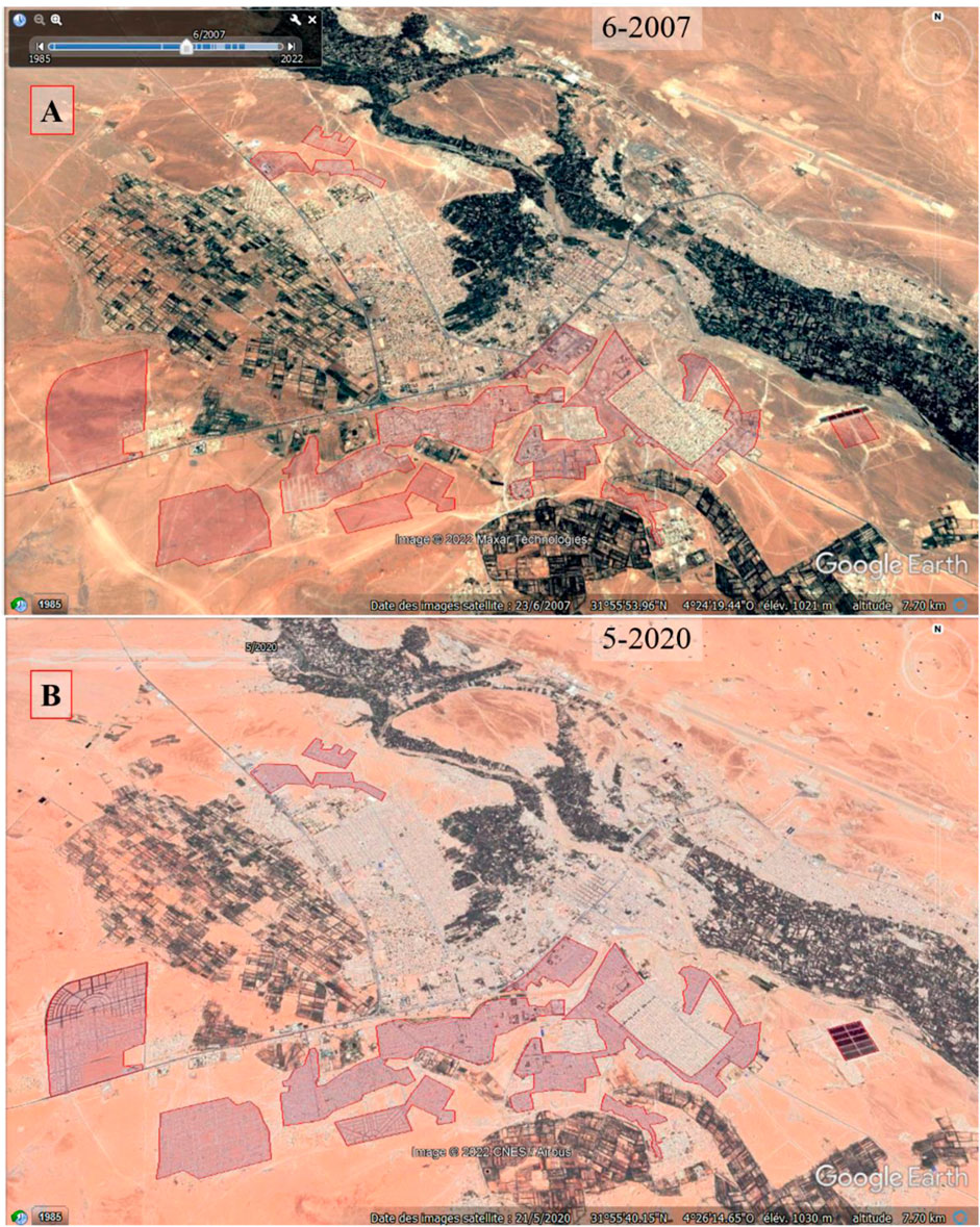
FIGURE 7. Change of the buildup area of Errachidia city in two years using Google Earth images. (A) in 2007; and (B) in 2020.
In the last 2 decades, the non-vegetated-lands area that represents the major land cover area decreased by 2%. This may indicate an increasing human pressure reflected in the average annual population growth rate from 2004 to 2014 in the urban area that estimated about 1.4 (HCP, 2014) and the urbanization rate about 46.4% the highest in the Draa-Tafilalet region (HCP, 2018). This trend places significant stress on ecosystems and particularly on groundwater resources. This impact will not be without effect on the aquatic and terrestrial ecosystems of the province. Using GRACE Model that estimates water storage including groundwater, the outputs show a strong decreasing trend in the last decade. It is additional proof that reflects the depletion of groundwater. This is consistent with the result of a study conducted on a water table aquifer located in Erg Chebbi (100-km2 dune complex) suggesting that this aquifer has been reduced by about 30% due to overuse in less than 50 years with a total consumed 20–60 Mm3 (García-Rodríguez et al., 2014). This last study reported also that for years, water requirements have overpassed the replenishment rate of the aquifer and this has induced a depletion of the water table.
This will constitute a further negative effect on the drinking water supply and agriculture. The regression trend can lead to advanced land degradation and a growing water resource-dependence accelerated by CC and droughts. In fact, according to Hermans and McLeman (Hermans and McLeman, 2021), droughts are serious drivers of land degradation, which causes the dependence of rural populations on resources and then conducted significantly to livelihood losses and migration. According to Kivivuori et al., 2012, plus the lack of jobs in rural areas, CC that makes drought longer, and desertification more extensive force inhabitants to migrate. Droughts and CC have also considerable impacts on water bodies such as rivers in arid and semi-arid areas (Noorisameleh et al., 2020).
The orientation to an extension of crops mainly of date palm and associated crops reflected in the increase of the percentage of the area was supported by the local and national governmental strategies. According to the report of the National Communication of Morocco to the United Nations Framework Convention on CC (Ministry in charge of the Environment) (MDMEMEE, 2016), the government launched a phoenicicultural program. This program aimed to plant one million date palms in the oases of Errachidia province with an initial budget of MAD 1.25 billion, followed by a second tranche of MAD 3.23 billion to cover until 2030 (MDMEMEE, 2016). In this report, the government conducted two programs that target the oasis development and the return of young people to the abandoned oases and their greening. The extension of date palm and other crops was recorded using Google Earth images. The change of this area near the HED and city of Errachidia is an example of this extension as shown in figure 7. A clear trend can be observed between June 2007 and Mai 2020 (available images). In 2007, in the selected area, there were no farms but in 2020 (Black square), the area was invaded by new farms with large reservoir for irrigation (Red and Yellow squares), estimated to 83 farm-reservoirs (Figure 8).
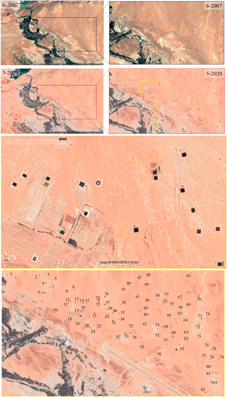
FIGURE 8. Change of the buildup area of Errachidia city in 2 years 2007 and 2020 using Google Earth images.
The regional office for agricultural development of Tafilalet (Errachidia) has published a note on the Project for the Development of Irrigation and Adaptation of Irrigated Agriculture to CC downstream of the Kaddoussa Dam (PDIAAI-CC) which aims to “adapt to CC through the transformation of irrigation and integrated territorial development.” Over a length of about 60 km, the project area covers the valley of the Guir wadi from the site of the Kaddoussa Dam to the Sehli perimeter downstream. According to this source, the extensions outside the oasis concern 4,075 ha of collective land operated by rights holders and investors mostly from outside the area. According to the official website of the Ministry of Agriculture of Morocco, this project was launched in 2018 for 836 million MAD, covers an area of 5,000 ha and should benefit 5,500 farmers in the Province. It should generate an increase in the added value of 50,000 MAD/ha/year according to the same source (https://www.agriculture.gov.ma/fr/projet/lirrigation-adaptee-aux-changements-climatiques).
The most relevant strategy in the field of agriculture is “Plan Maroc Vert,” which was implemented with the purpose to maximize industrial agriculture and alleviate poverty through the encouragement and the funding of economic irrigation practices and the use of solar energy to optimize productivity and tackle CC. However, this project is a double-edged sword because the financing of this free energy can cause the overexploitation of underground water resources that are difficult to renew (Benabderrazik et al., 2021). The soil and water in drylands are already fragile and exposed to salinity so they cannot support a growing population with such growing needs. In fact, from the Hassan Addakhil Dam (the big dam of the province) in upstream (North)-downstream (South) direction a considerable change in groundwater quality was found, mainly an increase in salinity from upstream with TDS −460 mg/L to downstream with a TDS −16,000 mg/L (Lgourna et al., 2015). This increasing rate in groundwater salinity was observed in similar oases regions of Morocco and also in the golf from the United Arab Emirates (Moumane et al., 2021; Gómez-Alday et al., 2022). The use of solar energy in the context of groundwater desalination is a promising strategy to adapt to CC and drought effects. Desalination is an ideal solution to solve the problem of water scarcity in dry areas (Mostafaeipour et al., 2021). The use of local crop varieties and livestock well adapted to arid climates are also ideal solutions to rationalize consumption and support soil fertility.
Outputs suggest that this province is, on a level, fragile to effects from meteorological, and socioeconomic sources. This trend implies that the province faces significant issues. Groundwater depletion represents the next most critical aspect of the province. These induce loss of vegetation, water, and soil qualities. These problems are consistent with those recorded for the province of Zagora that seriously affect local human beings (Karmaoui et al., 2021). Observed in the fully drying up of Iriki Lake, the migration, and degradation of a large part of the oasis of M’Hamid in the downstream of Zagora attributed to the construction of Mansour Eddahbi Dam in the upstream area of the province, the water overuse, and the prolonged periods of droughts. This was found by Karmaoui et al., 2018 in Zagora province, a neighbouring province in the southern part (more driest), reporting that this area is projected to suffer an increasing trend in dry years over the current century (2010–2099). According to this study, two additional impacts were explored, the high rate of evaporation that influences the soil moisture and its productivity (vegetation greenness) accelerated by the human pressure.
Despite the complex interactions between the impact of CC, anthropogenic pressure, and LULC classes, an attempt to distinguish these effects are provided to highlight which LULC class change results from CC and which from anthropogenic effect. Land-use type such as urbanization is influenced totally by human intervention to respond to the population and economic growth as reflected in the growth rate recorded in Errachidia as mentioned above. This development requires as well as an increase in the creation of new croplands and the conversion to permanent agriculture (apple tree and plum trees in mountainous area while palm and olive trees in the plains areas toward the south). However, this trend may be subject to climate risks in the near future, which can result in the reduction of water supply and then this threatens the local economy and particularly, the food security. The slight change in closed shrublands and savannas may be primarily due to the reported impact of nomads practices such as overgrazing that causes soil erosion and then the degradation of principally the juniper and the drought trend in the last decade. In the final report of the project of rural development in Errachidia Province, transhumant grazing is reported to be much practiced and during winter, livestock is grazed in the province and transferred to other provinces in summer to look for water and grazing grass areas (MI, 2012). In this governmental report, in addition to the over-grazing caused by inhabitants and nomads, farmland reclamation was also recorded. Wood harvesting constitutes an additional potential factor that can cause this slight decreasing trend. This was confirmed also by official data on the use of firewood from the Moroccan High Commission for Planning. In fact, according to the national census of population and housing of Morocco, the firewood used by the total provincial households represents 30.5% and 50% in rural areas (HCP, 2019), which indicates a strong pressure on local ecosystems. Otherwise, as stated by the global forest watch (https://www.globalforestwatch.org/), the province of Errachidia lost 0.0655ha of tree cover in the period 2001–2020, which is equivalent to a regression of about 3.6% since 2000. Concerning the change in water resources, the impact of both climate change and anthropogenic components is relatively easy to describe and demonstrate. Reported to the total area of the province, the water bodies are generally rare and the estimated change is slight since the area is arid. This decreasing trend in the last decade is probably attributed to multiple factors, climatic and anthropogenic. Particularly, it is due to the reduced supply because of the decreasing of the total annual precipitation, the high rate of evaporation, and the strong demand by a growing population.
Generally, according to the CC scenarios, the precipitations are likely to decrease while temperatures are likely to increase, which indicates a growing risk of droughts both at national and regional scales. Given this common trend in the oasis provinces with different degradation speeds, integrated management of water resources in this arid area is mandatory to reach sustainable development. Human impact and droughts seem to have the most dangerous influence on the provincial ecosystems particularly, the groundwater. Groundwater management is crucial and requires a participative and cooperative approach that involves government, local population, NGOs, farmers, competent authorities, particularly the water and agriculture administrations. Based on results using NDVI, NDWI, and EVI, Errachidia is subject to periods of drought that last several years and which can cause considerable losses through the regression of production. Thus, the current study strengthens the understanding of LULC and water storage potentials of the province. The use of different RS methods to estimate the change may validate the applicability despite the very small areas of water and vegetation cover reported to the total areas of this desert province. This suggest investigating the LULC to smallest areas to cover the areas where the water and vegetation are localized such as the Valleys, the Wadi, and the palm groves.
Limitations of the study
The RS techniques used in the current study allow to survey various aspects of land use and land cover, vegetation, weather, drought, water resources, urbanization, and agriculture. However, the application of these techniques is associated also with some limitations in terms of spatial scale, including the smallest scale of the study when applying the RS methods. The low resolution of the monthly water storage derived from GRACE-FO data is a second example. For this data, the equivalent water thickness represents the total mass anomalies over land plus potentially non-hydrological signals that haven’t been removed such as large earthquakes.
The temporal scale (2005–2020) of the RS application is also a limitation of this study. The observed data of precipitation in the 23 stations are heterogeneous and sometimes does not cover the entire period. These weaknesses can be resolved for upcoming research using a study on several provinces on a longer period using the most representative stations with complete data. The disregard of the field survey method is due to its expensive cost and a long time to conduct it. The lack of an updated database including the data on vegetation and water resources in the area makes it difficult to conduct this kind of study.
Conclusion
The current study takes advantage of RS technology using tools such as LULC, NDVI, NDWI, EVI, and GRACE Satellite data in a vulnerable and understudied area. To our knowledge, there are no studies combining these tools in the province of Errachidia. The paper provides a diagnosis of the states and trends of land and water resources of this arid province that is presently highly impacted by incidental effects from human pressure and drought. Moreover, groundwater, the soil quality, natural ecosystem are therefore at risk from the ongoing land development in the province. The findings of the current research reveal that significant changes in this province were explored. A decreasing trend in water bodies from 2011 to present, an increasing trend was recorded for the urban-and-built-up-lands and the grasslands categories, an increasing trend in the second half of the studdy period for croplands while the non-vegetated-lands followed a decreasing trend. The outputs of the indices NDVI, NDWI, and EVI showed three major peaks recorded in the same periods (in 2007, 2009, and 2015) explained by serious dry condition. In general, the trend for the entire period is negative with a marked fluctuation. In terms of groundwater resources, the GRACE model shows three phases. The first recorded the lowest groundwater quantities with a decreasing trend, which corresponds to a period of drought and/or human pressure. The second phase, the most important and which recorded the greatest storage of water. The third phase corresponds to low storage with a decreasing trend. LULC of water resources and cropland reveals two parallel peaks with a slightly increasing trend. This shows an orientation to an extension of crops mainly of date palm observed in an increasing number of installed farm-reservoirs near the city and in Boudnib area. A high correlation between NDVI and water storage-Data for the period was found, with a biphasic form. For the annual change of the period 2005–2020, the correlations revealed that NDVI_is moderate to strongly positive correlated with EVI (0.7265), NDWI (0.55), and relative humidity (0.697) while EVI is moderate to strongly associated with NDWI (0.7521) and water equivalent (0.6834), and weak to relative humidity (0.498), and precipitation (0.484). However, NDWI is moderate to strong associated with water equivalent (0.7423), relative humidity (0.639), and precipitation (0.5181). This indicates the importance of combining these indices to monitor the vegetation cover and water bodies. The statistical correlation change in the water storage and vegetation cover may indicate the sensitivity of these desert ecosystems and the vulnerability for any new extensions mainly for the unsustainable crops. The extensions should be performed with caution since the increasing areas of cropland intended for export may increase the overuse of groundwater in an arid area. This trend may threatens the sustainability of the desert ecosystems of the province and influence the capacity of the region to supply the drinking water for a growing urbanization. Indications and signs of this began to appear in the drying up of Iriki Lake in the neighboring province of Zagora and in some sites including the total drying up of Ain Msky in the study area.
The results showed that RS techniques are important approaches to detect hydrological droughts, observe, and conserve land and water resources. In areas such as Errachidia, rationalizing the use of water resources is needed to support sustainable development purposes in drylands, environmental scientists and decision-makers may use the outputs.
About decision-making, it can be concluded that the vulnerability of the Errachidia to the water-associated issues would be progressively overcome with careful management of ecosystem services and the monitoring of human uses.
Experimentation on human subjects
We confirm that the study complies with all regulations and confirmation that informed consent was obtained.
Data availability statement
The raw data supporting the conclusion of this article will be made available by the authors, without undue reservation.
Author contributions
Conceptualization, AK; data curation, AB; investigation, AK and LH; methodology, AK and AB; project administration, SE, HC, and LH; Resources, AK, AB, AM, SE, HC, and LH; supervision, SE and LH; writing—original draft, AK; writing—review and editing, AK, AB, AM, SE, HC, and LH.
Funding
This work was supported by the Institutional University Cooperation program with Moulay Ismail University, which is funded by the VLIR-UOS (Phase I: 2017–2021; Contract no MA2017IUC038A104).
Acknowledgments
Many thanks to the reviewers for their valuable review comments.
Conflict of interest
The authors declare that the research was conducted in the absence of any commercial or financial relationships that could be construed as a potential conflict of interest.
Publisher’s note
All claims expressed in this article are solely those of the authors and do not necessarily represent those of their affiliated organizations, or those of the publisher, the editors and the reviewers. Any product that may be evaluated in this article, or claim that may be made by its manufacturer, is not guaranteed or endorsed by the publisher.
Appendix A:
Correlation between the trend in vegetation cover using the NDVI, NDWI, and EVI over the period of the study using the statistical analysis
References
Abdelfadel, F., Hilali, M., Fontaine, C., El Albani, A., Mahboub, A., Eloy, L., et al. (2020). Hydrogeology of a complex aquifer system in semi-arid mountainous region: The eastern upper Guir Basin in the high Atlas (Morocco). Water 12 (10), 2849. doi:10.3390/w12102849
Acharya, T. D., Subedi, A., Yang, I. T., and Lee, D. H. (2017). Combining water indices for water and background threshold in Landsat image. Multidiscip. Digit. Publ. Inst. Proc. 2 (3), 143. doi:10.3390/ecsa-4-04902
Alsaady, W. F., and Mohammed, R. (2021). Detecting of climatic drought by combination geo-information system and remote sensing in semi-arid zones: A case study. Mater. Today Proc. doi:10.1016/j.matpr.2021.04.625
AρρEEARS (2021). Application for extracting and exploring analysis Ready Samples (AppEEARS). Ver. 2.67. Sioux Falls, South Dakota, USA: NASA EOSDIS Land Processes Distributed Active Archive Center (LP DAAC), USGS/Earth Resources Observation and Science (EROS) Center. Available at: https://lpdaacsvc.cr.usgs.gov/appeears (Accessed December 25, 2021).
Ben Salem, A., Messouli, M., and Yacoubi-Khebiza, M. (2011). Developing an oasis-based water management tool: Ecohydrologic approach and weap software for a large arid catchment in Morocco. Int. J. Water Resour. Arid Environ. 1 (6), 387–396. Available at: https://www.psipw.org/attachments/article/308/IJWRAE_1(6)387-396.pdf.
Ben Salem, S., Ben Salem, A., Karmaoui, A., Khebiza Yacoubi, M., and Messouli, M. (2019). Quantification and evaluation of water erosion: Application of the model SDR – InVEST in the Ziz Basin in south-east Morocco decision support Methods for assessing flood Risk and vulnerability. Igi Glob. doi:10.4018/978-1-5225-9771-1.ch007
Ben-said, E., Boukdir, A., Mahboub, A., Younsi, A., El Moquaddam, K., Alili, L., et al. (2017). Apport de la statistique à l’étude des interactions entre la nappe jurassique et le barrage Hassan Addakhil (Errachidia). Am. J. Innov. Res. Appl. Sci. 5 (6), 476–486. Available at: https://american-jiras.com/Abstract10_December_2017.html.
Benabderrazik, K., Kopainsky, B., Tazi, L., Joerin, J., and Six, J. (2021). Agricultural intensification can no longer ignore water conservation – a systemic modelling approach to the case of tomato producers in Morocco. Agric. Water Manag. 256, 107082. doi:10.1016/j.agwat.2021.107082
Bouaamlat, I., Larabi, A., and Faouzi, M. (2016). Hydrogeological investigation of an oasis-system aquifer in arid southeastern Morocco by development of a groundwater flow model. Hydrogeol. J. 24 (6), 1479–1496. doi:10.1007/s10040-016-1409-8
Bouhlali, E. D. T., Derouich, M., Ben-Amar, H., Meziani, R., and Essarioui, A. (2020). Exploring the potential of using bioactive plant products in the management of Fusarium oxysporum f. sp. albedinis: The causal agent of bayoud disease on date palm (phoenix dactylifera L.). Beni. Suef. Univ. J. Basic Appl. Sci. 9 (1), 46–49. doi:10.1186/s43088-020-00071-x
de la Casa, A., Ovando, G., and Díaz, G. (2021). Linking data of ENSO, NDVI-MODIS and crops yield as a base of an early warning system for agriculture in Córdoba, Argentina. Remote Sens. Appl. Soc. Environ. 22, 100480. doi:10.1016/j.rsase.2021.100480
Didan, K. (2015) MOD13A3 MODIS/terra vegetation indices monthly L3 global 1km SIN grid V006. NASA EOSDIS Land Processes DAAC. Accessed December 25, 2021. doi:10.5067/MODIS/MOD13A3.006
Eddouks, M., Ajebli, M., and Hebi, M. (2017). Ethnopharmacological survey of medicinal plants used in Daraa-Tafilalet region (Province of Errachidia), Morocco. J. Ethnopharmacol. 198, 516–530. doi:10.1016/j.jep.2016.12.017
El hafyani, M., Essahlaoui, A., El baghdadi, M., Teodoro, A. C., Mohajane, M., El hmaidi, A., et al. (2019). Modeling and mapping of soil salinity in Tafilalet plain (Morocco). Arab. J. Geosci. 12, 35. doi:10.1007/s12517-018-4202-2
Essahlaoui, A., and Abba, M. (2012). Contribution of remote sensing and GIS for the study of the evolution of the spatial and temporal of land use in the Ziz Middle, Errachidia region (Morroco). Res. J. Earth Sci. (RJES) 4 (2), 37–43. Available at: https://www.cabdirect.org/cabdirect/abstract/20133387976.
Essarioui, A., and Sedra, M. H. (2017). Lutte contre la maladie du bayoud par solarisation et fumigation du sol. Une expérimentation dans les palmeraies du Maroc. Cah. Agric. 26 (4), 45010. doi:10.1051/cagri/2017043
Fan, P. Y., Chun, K. P., Mijic, A., Tan, M. L., He, Q., and Yetemen, O. (2021). Quantifying land use heterogeneity on drought conditions for mitigation strategies development in the Dongjiang River Basin, China. Ecol. Indic. 129, 107945. doi:10.1016/j.ecolind.2021.107945
Friedl, M. A., Sulla-Menashe, D., Tan, B., Schneider, A., Ramankutty, N., Sibley, A., et al. (2010). MODIS Collection 5 global land cover: Algorithm refinements and characterization of new datasets. Remote Sens. Environ. 114 (1), 168–182. doi:10.1016/j.rse.2009.08.016
Gao, B. C. (1995). “Normalized difference water index for remote sensing of vegetation liquid water from space,” in Imaging spectrometry (Bellingham, Washington, USA: International Society for Optics and Photonics), Vol. 2480, 225–236. doi:10.1117/12.210877
García-Rodríguez, M., Antón, L., and Martinez-Santos, P. (2014). Estimating groundwater resources in remote desert environments by coupling geographic information systems with groundwater modeling (Erg Chebbi, Morocco). J. arid Environ. 110, 19–29. doi:10.1016/j.jaridenv.2014.05.026
Girotto, M., and Rodell, M. (2019). “Terrestrial water storage,” in Extreme hydroclimatic events and multivariate hazards in a changing environment (Amsterdam, Netherlands: Elsevier), 41–64. doi:10.1016/B978-0-12-814899-0.00002-X
Gómez-Alday, J. J., Hussein, S., Arman, H., Alshamsi, D., Murad, A., Elhaj, K., et al. (2022). A multi-isotopic evaluation of groundwater in a rapidly developing area and implications for water management in hyper-arid regions. Sci. Total Environ. 805, 150245. doi:10.1016/j.scitotenv.2021.150245
Gonzalez-Gonzalez, M. A., and Guertin, D. P. (2021). Seasonal bean yield forecast for non-irrigated croplands through climate and vegetation index data: Geospatial effects. Int. J. Appl. Earth Observation Geoinformation 105, 102623. doi:10.1016/j.jag.2021.102623
Häder, D. P., and Barnes, P. W. (2019). Comparing the impacts of climate change on the responses and linkages between terrestrial and aquatic ecosystems. Sci. Total Environ. 682, 239–246. doi:10.1016/j.scitotenv.2019.05.024
Hansen, M. C., DeFries, R. S., Townshend, J. R., and Sohlberg, R. (2000). Global land cover classification at 1 km spatial resolution using a classification tree approach. Int. J. remote Sens. 21 (6-7), 1331–1364. doi:10.1080/014311600210209
HCP (2014). High commission for planning based on the last census of population and housing. Royaume du Maroc: HCP. Available at: http://rgphentableaux.hcp.ma/Default1/.
HCP (2019). Monographie de la province d’Errachidia. Royaume du Maroc: High Commission for Planning. Direction Regionale de Draa-Tafilalet, 101.
HCP (2018). Regional monograpghy of 2016. Royaume du Maroc: High Commission for Planning. Direction Regionale de Draa-Tafilalet, 149.
Hermans, K., and McLeman, R. (2021). Climate change, drought, land degradation and migration: Exploring the linkages. Curr. Opin. Environ. Sustain. 50, 236–244. doi:10.1016/j.cosust.2021.04.013
Herzog, M., Henselowsky, F., and Bubenzer, O. (2021). Geomorphology of the Tafilalt Basin, South-East Morocco–implications for fluvial–aeolian dynamics and wind regimes. J. Maps 17 (2), 682–689. doi:10.1080/17445647.2021.1990805
Higginbottom, T., and Symeonakis, E. (2014). Assessing land degradation and desertification using vegetation index data: Current frameworks and future directions. Remote Sens. 6, 9552–9575. doi:10.3390/rs6109552
Hoque, M. A. A., Pradhan, B., and Ahmed, N. (2020). Assessing drought vulnerability using geospatial techniques in northwestern part of Bangladesh. Sci. Total Environ. 705, 135957. doi:10.1016/j.scitotenv.2019.135957
Kabiri, L. (2012). “Desertification trends and local action in the oases of Tafilalt, south-east Morocco (8-19),” in Encounters across the Atlas: Fieldtrip in Morocco 2011. Editors P. Minoia, and I. Kaakinen, 142. ISSN 0786-2172. Available at: https://iris.unito.it/retrieve/handle/2318/1790340/764713/Encounters_Across_The_Atlas_Fieldtrip_in.pdf.
Karmaoui, A., and Balica, S. (2021). A new flood vulnerability index adapted for the pre-Saharan region. Int. J. River Basin Manag. 19 (1), 93–107. doi:10.1080/15715124.2019.1583668
Karmaoui, A., El Jaafari, S., Chaachouay, H., and Hajji, L. (2021). The socio-ecological system of the pre-sahara zone of Morocco: A conceptual framework to analyse the impact of drought and desertification. GeoJournal 2021, 1–14. doi:10.1007/s10708-021-10546-8
Karmaoui, A., Minucci, G., Messouli, M., YacoubiKhebiza, M., Ifaadassan, I., and Babqiqi, A. (2018). “Climate change impacts on water supply system of the middle Draa valley in south Morocco,” in Climate change, food security and natural resource management. Editors M. Behnassi, O. Pollmann, and H. Gupta (Cham: Springer). doi:10.1007/978-3-319-97091-2_8
Karmaoui, A., Sereno, D., Maia, C., Campino, L., El Jaafari, S., Chaachouay, H., et al. (2022). A conceptual model for understanding the zoonotic cutaneous leishmaniasis transmission risk in the Moroccan pre-Saharan area. Parasite Epidemiol. Control 17, e00243. doi:10.1016/j.parepi.2022.e00243
Kivivuori, B., Niemelä, J., and Andersson, M. (2012). “Rural-urban migration in the Tafilalet region (72-82),” in Encounters across the Atlas: Fieldtrip in Morocco 2011. Editors P. Minoia, and I. Kaakinen, 142. ISSN 0786-2172. Available at: https://iris.unito.it/retrieve/handle/2318/1790340/764713/Encounters_Across_The_Atlas_Fieldtrip_in.pdf.
Kumar, B. P., Babu, K. R., Anusha, B. N., and Rajasekhar, M. (2022). Geo-environmental monitoring and assessment of land degradation and desertification in the semi-arid regions using Landsat 8 OLI/TIRS, LST, and NDVI approach. Environ. Challenges 8, 100578. doi:10.1016/j.envc.2022.100578
Kumar, B. P., Babu, K. R., Ramachandra, M., Krupavathi, C., Swamy, B. N., Sreenivasulu, Y., et al. (2020). Data on identification of desertified regions in Anantapur district, Southern India by NDVI approach using remote sensing and GIS. Data brief 30, 105560. doi:10.1016/j.dib.2020.105560
Kumar, K. S., Rathnam, E. V., and Sridhar, V. (2021). Tracking seasonal and monthly drought with GRACE-based terrestrial water storage assessments over major river basins in South India. Sci. Total Environ. 763, 142994. doi:10.1016/j.scitotenv.2020.142994
Landerer, F. W., and Cooley, S. S. (2021). Gravity Recovery and climate experiment follow-on (GRACE-FO). Level-3 data product, user handbook. La Cañada Flintridge, California: NASA Jet Propulsion Laboratory, 62.
Lgourna, Z., Warner, N., Bouchaou, L., Boutaleb, S., Hssaisoune, M., Tagma, T., et al. (2015). Elucidating the sources and mechanisms of groundwater salinization in the Ziz Basin of southeastern Morocco. Environ. Earth Sci. 73 (1), 77–93. doi:10.1007/s12665-014-3396-1
Liu, H. Q., and Huete, A. (1995). A feedback based modification of the NDVI to minimize canopy background and atmospheric noise. IEEE Trans. Geosci. Remote Sens. 33 (2), 457–465. doi:10.1109/TGRS.1995.8746027
Lu, S., Wu, B., Yan, N., and Wang, H. (2011). Water body mapping method with HJ-1A/B satellite imagery. Int. J. Appl. Earth Observation Geoinformation 13 (3), 428–434. doi:10.1016/j.jag.2010.09.006
Mainguet, M., Dumay, F., Kabiri, L., and Rémini, B. (2011). “Prodromes of desertification in the oasis of tafilalet (Morocco) and specific local solutions,” in Coping with global environmental change, disasters and security, hexagon series on human and environmental security and peace. Editors H. G. Brauch, Ú. Oswald Spring, C. Mesjasz, J. Grin, P. Kameri-Mbote, B. Chourouet al. (Berlin, Heidelberg: Springer Berlin Heidelberg), 901–919. doi:10.1007/978-3-642-17776-7_53
Manaouch, M., Zouagui, A., and Fenjiro, I. (2020). “Regional-scale modeling of water erosion and sediment yield in a semi-arid context: Case study of Ziz upper watershed in south-eastern Morocco,” in Proceedings of the 4th Edition of International Conference on Geo-IT and Water Resources, Geo-IT and Water Resources, 1–5. doi:10.1145/3399205.3399209
MDMEMEE (2016). 3e RAPPORT, Communication Nationale du Maroc à la Convention Cadre des Nations Unies sur les Changements Climatiques. Avril 2016. Royaume du Maroc: Ministère Délégué auprès du Ministre de l’Energie, des Mines, de l’Eau et de l’Environnement Chargé de l’Environnement, 296.
Meddich, A., Jaiti, F., Bourzik, W., El Asli, A., and Hafidi, M. (2015). Use of mycorrhizal fungi as a strategy for improving the drought tolerance in date palm (Phoenix dactylifera). Sci. Hortic. 192, 468–474. doi:10.1016/j.scienta.2015.06.024
MI (2012). Ministère de l’intérieur Diréction Général des Collectivités Locales. The study on the project of rural development in Errachidia Province. Bangkok, Thailand: Japan International Cooperation Agency SANYU CONSULTANTS INC, 211. Final Report, February 2012.
Michael, Y., Helman, D., Glickman, O., Gabay, D., Brenner, S., and Lensky, I. M. (2021). Forecasting fire risk with machine learning and dynamic information derived from satellite vegetation index time-series. Sci. Total Environ. 764, 142844. doi:10.1016/j.scitotenv.2020.142844
Mostafaeipour, A., Mohammadi, S. M., Najafi, F., and Issakhov, A. (2021). Investigation of implementing solar energy for groundwater desalination in arid and dry regions: A case study. Desalination 512, 115039. doi:10.1016/j.desal.2021.115039
Moumane, A., El Ghazali, F. E., Al Karkouri, J., Delorme, J., Batchi, M., Chafiki, D., et al. (2021). Monitoring spatiotemporal variation of groundwater level and salinity under land use change using integrated field measurements, GIS, geostatistical, and remote-sensing approach: Case study of the feija aquifer, middle Draa watershed, Moroccan sahara. Environ. Monit. Assess. 193, 769. doi:10.1007/s10661-021-09581-2
Nanzad, L., Zhang, J., Tuvdendorj, B., Nabil, M., Zhang, S., and Bai, Y. (2019). NDVI anomaly for drought monitoring and its correlation with climate factors over Mongolia from 2000 to 2016. J. Arid Environ. 164, 69–77. doi:10.1016/j.jaridenv.2019.01.019
Noorisameleh, Z., Khaledi, S., Shakiba, A., Firouzabadi, P. Z., Gough, W. A., and Mirza, M. M. Q. (2020). Comparative evaluation of impacts of climate change and droughts on river flow vulnerability in Iran. Water Sci. Eng. 13 (4), 265–274. doi:10.1016/j.wse.2020.05.001
Ougougdal, H. A., Khebiza, M. Y., Messouli, M., Bounoua, L., and Karmaoui, A. (2020). Delineation of vulnerable areas to water erosion in a mountain region using SDR-InVEST model: A case study of the ourika watershed, Morocco. Sci. Afr. 10, e00646. doi:10.1016/j.sciaf.2020.e00646
Puy, A., Herzog, M., Escriche, P., Marouche, A., Oubana, Y., and Bubenzer, O. (2018). Detection of sand encroachment patterns in desert oases. The case of Erg Chebbi (Morocco). Sci. total Environ. 642, 241–249. doi:10.1016/j.scitotenv.2018.05.343
Roznik, M., Boyd, M., and Porth, L. (2022). Improving crop yield estimation by applying higher resolution satellite NDVI imagery and high-resolution cropland masks. Remote Sens. Appl. Soc. Environ. 2022, 100693. doi:10.1016/j.rsase.2022.100693
Sedra, H. (2012). “Date palm farmer guide: Implementation and management of date palm orchards,” Paper cover in French (Guide du Phoeniciculteur: Mise en place et conduite des vergers phoénicicoles) (Morocco: INRA), 311. ISBN/IPC: 978-9954-8602-8-1.
Sedra, M. H. (2015). “Date palm status and perspective in Morocco,” in Date palm genetic resources and utilization. Editors J. M. Al-Khayri, S. M. Jain, and D. V. Johnson (Dordrecht: Springer Netherlands), 257–323. doi:10.1007/978-94-017-9694-1_8
Sinsin, T., Mounir, F., and El Aboudi, A. (2021). Modeling and assessing driving factors of the spatial and temporal dynamics of the sand dunes in the district of Errachidia, Morocco. Arab. J. Geosci. 14 (20), 2111–2125. doi:10.1007/s12517-021-08423-2
Spinoni, J., Barbosa, P., Cherlet, M., Forzieri, G., McCormick, N., Naumann, G., et al. (2021). How will the progressive global increase of arid areas affect population and land-use in the 21st century? Glob. Planet. Change 205, 103597. doi:10.1016/j.gloplacha.2021.103597
Wang, F., Lai, H., Li, Y., Feng, K., Zhang, Z., Tian, Q., et al. (2022). Identifying the status of groundwater drought from a GRACE mascon model perspective across China during 2003–2018. Agric. Water Manag. 260, 107251. doi:10.1016/j.agwat.2021.107251
Xie, F., and Fan, H. (2021). Deriving drought indices from MODIS vegetation indices (NDVI/EVI) and Land Surface Temperature (LST): Is data reconstruction necessary? Int. J. Appl. Earth Observation Geoinformation 101, 102352. doi:10.1016/j.jag.2021.102352
Yifru, B. A., Chung, I. M., Kim, M. G., and Chang, S. W. (2021). Assessing the effect of land/use land cover and climate change on water yield and groundwater recharge in East African Rift Valley using integrated model. J. Hydrology Regional Stud. 37, 100926. doi:10.1016/j.ejrh.2021.100926
Keywords: Drought, Water, Groundwater, dryland, vegetation cover, NDVI, arid areas, oasis
Citation: Karmaoui A, Ben Salem A, El Jaafari S, Chaachouay H, Moumane A and Hajji L (2022) Exploring the land use and land cover change in the period 2005–2020 in the province of Errachidia, the pre-sahara of Morocco. Front. Earth Sci. 10:962097. doi: 10.3389/feart.2022.962097
Received: 09 June 2022; Accepted: 19 October 2022;
Published: 10 November 2022.
Edited by:
Shuisen Chen, Guangzhou Institute of Geography, ChinaReviewed by:
Sudhir Kumar Singh, Allahabad University, IndiaBoutasknit Abderrahim, Cadi Ayyad University, Morocco
Copyright © 2022 Karmaoui, Ben Salem, El Jaafari, Chaachouay, Moumane and Hajji. This is an open-access article distributed under the terms of the Creative Commons Attribution License (CC BY). The use, distribution or reproduction in other forums is permitted, provided the original author(s) and the copyright owner(s) are credited and that the original publication in this journal is cited, in accordance with accepted academic practice. No use, distribution or reproduction is permitted which does not comply with these terms.
*Correspondence: Ahmed Karmaoui, YS5rYXJtYW91aUB1bWkuYWMubWE=