
94% of researchers rate our articles as excellent or good
Learn more about the work of our research integrity team to safeguard the quality of each article we publish.
Find out more
ORIGINAL RESEARCH article
Front. Earth Sci., 30 August 2022
Sec. Structural Geology and Tectonics
Volume 10 - 2022 | https://doi.org/10.3389/feart.2022.956594
This article is part of the Research TopicEffects of Deep Fluids in Hydrocarbon Accumulations in Sedimentary BasinsView all 26 articles
 Rui Sun1
 Xingzong Yao2
 Xiayang Wang3Keqiang Wu1Yinxue Han4Jianyong Xu1Haizhang Yang1Hongyi Li1Qingbo Zeng1
 Zezhang Song5,6*
As the main target of deepwater oil and gas exploration, submarine fans are also the frontier and focus of sedimentology research. Based on the latest three-dimensional (3D) seismic data covering the study area, as well as heavy mineral, rare earth elements, and other data and guided by the theory of seismic sedimentology, this study analyzes the lower Miocene provenance system and sediment dispersion system in the eastern deepwater area of the Qiongdongnan Basin, northern South China Sea, from the perspective of source-to-sink system research. Our research defines the sediment supply function of provenance, paleogeomorphology and valley transport system, sedimentation results and distribution, and the coupling relationship between the source–channel–sink system and comprehensively constructs a set of application guidelines of source-to-sink system research to guide the exploration and prediction of favorable play in the study area and other similar basins. This study shows that in the early Miocene, as controlled by tectonics and paleogeomorphology, uplift areas developed on both the northern and southern sides of the Songnan, Baodao, and Changchang Sags in the Qiongdongnan Basin and small provenances of near-sag uplifts were found in the southern part of the sag. The provenance area in the northern part of the sag was large but not unified, and it formed different provenance systems consisting of the Hainan Uplift in the northern Songnan Sag, Hainan Uplift in the northern Baodao Sag, and Shenhu Uplift in the northern Changchang Sag. A series of canyon systems that developed in the early Miocene were the main channels for sediment transport from the shelf to the slope in the northern Songnan, Baodao, and Changchang Sags. In the early stage of the early Miocene, due to regional sea level decline, the scale of the canyons was generally large, and the scale of the canyons on the northern edge of the Songnan Sag was significantly larger than that of the Baodao Sag. As the relative sea level rose, the canyons became small, narrow, and shallow in the late stage of the early Miocene. Under the dual control of the “source–channel” system, multiple “delta–canyon–submarine fan” depositional systems developed in the Songnan, Baodao, and Changchang Sags in the early Miocene, and large deltas in the depositional systems were mainly located along the northern part of the sag and prograded to the shelf edge of the northern Songnan, Baodao, and Changchang Sags from north to south, providing a good material basis for the development of deepwater sediments.
In recent years, gravity flow deposits have been an important topic in sedimentary basin research and oil and gas exploration. More than 60 countries have conducted oil and gas exploration to search for deepwater gravity flow deposits, and the exploration results are remarkable, especially in the Gulf of Mexico Basin, the Bay of Bengal Basin, the North Sea Basin, and the Congo Basin, where large oil and gas fields have been discovered successively (Stow and Mayall, 2000). Although research and exploration of gravity flow deposits in China started relatively late, remarkable oil and gas discoveries have been made in the Pearl River submarine fans in the Baiyun Sag of the Pearl River Mouth Basin (Pang et al., 2006, 2007; Xie W. Y. et al., 2008), the Dongfang submarine fans in the Yinggehai Basin (Xu H. Z. et al., 2014; Xie and Huang, 2014), and the Central Canyon in the Qiongdongnan Basin (QB) (Wang, 2012; Xu X. D. et al., 2014); these discoveries also confirm that deepwater depositional systems are an important research field and main direction for breakthroughs in deepwater oil and gas exploration in the northern South China Sea. Clarifying the source-to-sink system and sedimentary characteristics of the submarine fans in the deepwater area of the northern South China Sea is the key to exploration breakthroughs, and it is also an intensely debated research topic of the deepwater depositional system in the northern South China Sea (Xie et al., 2016).
Domestic and foreign scholars have carried out research on the types of source-to-sink systems according to the differences in provenance, sediment transport channels, and depositional system types (Martinsen et al., 2005, 2010). Lin et al., 2015 studied the geomorphic evolution and source-to-sink system of the Earth’s surface, discussed the geomorphic unit composition of the source-to-sink from land to ocean, and summarized the basic model of the source-to-sink system from erosion to sedimentation and from land to the ocean. Pang et al., 2007 established a source-to-sink coupling system in a 13.8 Ma shelf edge delta and submarine fans on a slope in the Pearl River Mouth Basin according to the sedimentary system response relationship between the shallow shelf and deepwater slope of the passive continental margin basin in the northern South China Sea. Zhu et al., 2014 applied sequence stratigraphy and the theory of seismic sedimentology and paleogeomorphic restoration and combined it with 3D high-resolution seismic data to carefully characterize the source channels and depositional systems of the Dongying Formation on the west slope of the Bozhong Sag; they established three different spatial source–channel–sink coupling modes based on the differences in sediment channels to guide the prediction of favorable reservoirs in the region. Xu et al., 2017 believed that source system analysis, reservoir quantitative prediction, multidisciplinary and multimethod integration, and the formation of industrial application standards are the future trends in the development of source-to-sink sedimentary system research.
The Central Depression Belt is the largest secondary structural unit in the Qiongdongnan Basin, and it is estimated that prospective oil and gas resources account for more than 60% of the total resources in the basin (Xie et al., 2016). At present, major natural gas discoveries have been made in the Central Canyon, which developed during the late Miocene and Neogene in the Ledong and Lingshui Sag segments and has proven reserves of more than 100 billion cubic meters. The first deepwater gas field in Chinese waters has been found in the Ledong and Lingshui Sags, with a reserve scale up to 100 billion cubic meters (Wang, 2012, 2016; Xu H. Z. et al., 2014); this discovery is a significant oil and gas breakthrough in the western segment of the deep waters of the QB. However, the Songnan, Baodao, and Changchang Sags in the deepwater area of the Qiongdongnan Basin, as a large hydrocarbon-rich depression (Zhang et al., 2014), have not yet obtained a breakthrough in commercial oil and gas exploration. The main reason is that the sedimentary environment and sedimentary system of the eastern Central Depression are not thoroughly and objectively understood (Xie et al., 2016). Affected by the regional tectonic pattern of uplifts alternating with sags, the QB generally contains multiple sedimentary offloading areas and lacks injection by large rivers with large drainage areas. The basin generally has a scattered and small-scale provenance. The sedimentary systems are mainly proximal (fan) deltas. The scales of the deltas are relatively small, their volumes are relatively limited, and the reservoir types and spatial distributions are complex. Therefore, an analysis of the source-to-sink system is essential for understanding the filling and evolution process of basins, analyzing the temporal and spatial distribution of sand bodies, discussing the main factors controlling sand body development, predicting the favorable development zone of sand bodies, and optimizing the exploration zone and exploration targets. Based on the latest 3D seismic data, this study analyzes the source-to-sink system of submarine fans developed in the lower Miocene strata in the eastern deepwater area of the QB to attain an essential foundation for oil and gas exploration.
The Qiongdongnan Basin, located in the western segment of the northern continental margin of the South China Sea, is a Cenozoic passive continental margin rift basin formed under the action of regional extensional stress during the expansion of the new South China Sea, which includes the Northern Depression Belt, the Central Uplift Belt, the Central Depression Belt, and the Southern Uplift Belt (Zhang et al., 2007, 2015; Lei et al., 2011). The deepwater area (water depth >300 m) is nearly 4.5 × 10⁴ km2, is bounded by the Songnan Low Uplift, and is divided into the Ledong and Lingshui Sags in the west and the Songnan, Baodao, and Changchang Sags in the east (Figure 1).
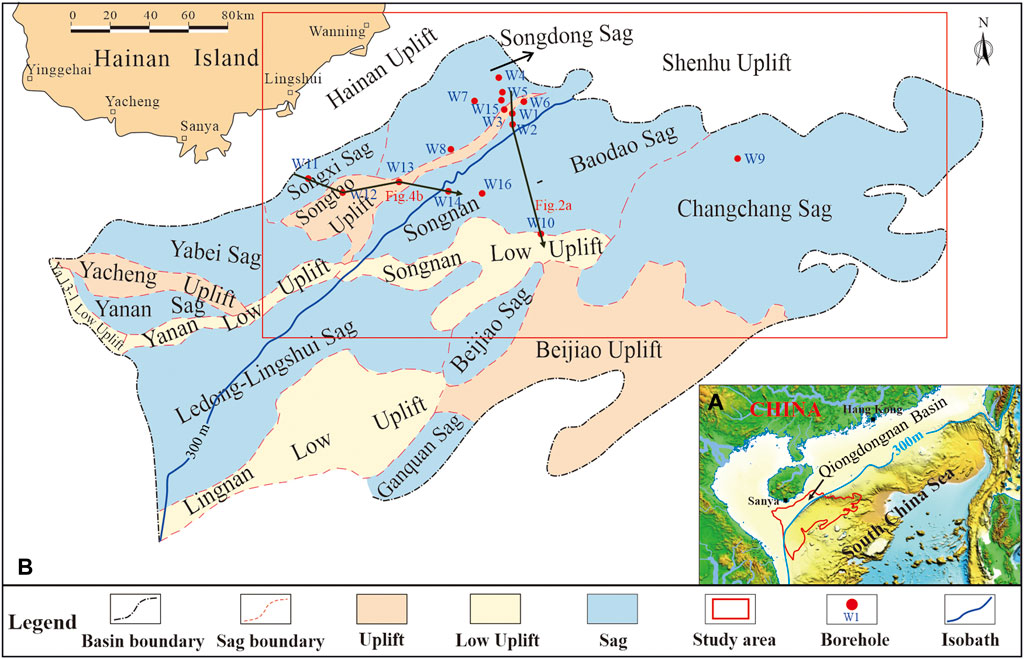
FIGURE 1. Tectonic units of the Qiongdongnan Basin, which is divided into the Ledong and Lingshui Sags in the west and the Songnan, Baodao, and Changchang Sags in the east, with the Songnan Low Uplift as the boundary. (A) shows the location of the Qiongdongnan Basin in the northern South China Sea, (B) shows the tectonic units of the Qiongdongnan Basin, and the red rectangle shows the study area.
The tectonic evolution of the Qiongdongnan Basin has been affected by the Pacific–Philippine Sea plate, India-Eurasia plate, South China Sea expansion, and Red River Fault and regional tectonic events that have occurred around Taiwan (Xie Y. H. et al., 2008; Yu et al., 2009; Su et al., 2012; Huang et al., 2014; Xie, 2014; Wang D. W. et al., 2015; Hui et al., 2016). The Tibetan Plateau uplift event led to development of large-scale sedimentation and subsidence in the Ledong and Lingshui Sags during the neotectonic period because it is close to the Red River Fault Zone. The South China Sea expansion event led to a change in the fault stress direction of the Songnan, Baodao, and Changchang Sags because it is close to the northwestern subbasin. The tectonic evolution of the QB experienced four stages: rifting, rift-depression, thermal sedimentation, and accelerated sedimentation (Li et al., 2006; Hu et al., 2013; Franke et al., 2014; Cao et al., 2015; Morley, 2016). During the sedimentary period of the Yacheng Formation in the early Oligocene, littoral facies developed in the northern and southern margins of the basin, neritic facies developed in the center of the basin, and small fan deltas developed in the northern part of the basin. During the sedimentary period of the Lingshui Formation in the late Oligocene, the relative sea level continued to rise, and the sedimentary range of neritic facies in the center of the basin increased significantly. During the sedimentary period of the Sanya Formation in the early Miocene, the basin entered the depression period, and the bathyal facies began to develop in the center of the basin. The supply of terrigenous debris to the northern slope zone was sufficient, delta deposits developed, and many submarine fans developed in the semi-deep sea at the front of the delta. During the sedimentary period of the Meishan Formation in the middle Miocene, the basin was dominated by littoral and neritic facies, and reefs developed locally on the southern margin of the basin. During the sedimentary periods of the Huangliu Formation in the late Miocene and the Yinggehai Formation in the Pliocene, due to the continuous transgression, the sedimentary range of the basin’s bathyal facies was further expanded, large-scale submarine fans developed on the western edge of the basin, and a large-scale Central Canyon developed in the center of the basin (Figure 2; Gong et al., 2014; Wang et al., 2013, Wang Z. F. et al., 2015; Yuan et al., 2009; Zhao Z. X. et al., 2015; Xie et al., 2007; Shao et al., 2010; Sun et al., 2019).
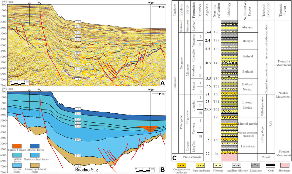
FIGURE 2. (A,B) show stratum filling (the location of the seismic profile is shown in Figure 1) and (C) shows a comprehensive chart of the eastern deepwater area in the Qiongdongnan Basin. The sedimentary system of submarine fans studied in this article belongs to the lower Miocene Sanya Formation.
The data used in this study include 2D and 3D seismic data, logging data, and rare earth element (REE) data. The density of the 2D seismic survey line in the study area is 4 × 4 km, and the total area of three-dimensional seismic data is approximately 10,000 km2. More than 20 wells have been drilled in the lower Miocene strata in the eastern deepwater area of the QB. Acoustic and density logging data are used to produce synthetic seismograms for well–seismic correlation. This study provides the heavy mineral components of five wells (W2, W6, W7, W9, and W10) and makes a comparative analysis with the research results of Cao et al., 2015. The REE data used for provenance analysis and comparison are mainly derived from the analytical results of predecessors in different regions. Among them, the REE data of the Red River are derived from Wang et al., 2011 and Zhao et al., 2015a, the REE data of Hainan Island are quoted from Shao et al., 2010, and the REE data of eastern Vietnam are from Zhao M. et al., 2015.
Based on an investigation and summary of previous research results, guided by the theoretical results of seismic sedimentology, the provenance system and sediment dispersion system of the lower Miocene Sanya Formation in the eastern deepwater area of the QB are analyzed from the perspective of the source-to-sink system by applying the geological, drilling and logging, core and 3D seismic data in the study area to clarify the formation and sediment supply of provenance, the gully transport system, sedimentary response, and distribution characteristics and establish a depositional model to guide the exploration of favorable play.
Five typical sedimentary facies, namely, submarine fan, delta, littoral, neritic and bathyal are identified through the analysis of seismic facies and single-well facies of the lower Miocene Sanya Formation in the Songnan, Baodao, and Changchang Sags in the eastern deepwater area of the QB.
The submarine fan is a composite sedimentary body developed on continental slopes and deep-sea basins and formed by sediment gravity flow. The submarine fan facies is an important sedimentary facies type of the Sanya Formation. The drilling of well W16 encountered the submarine fan facies of the Sanya Formation in the lower Miocene strata. The lithology of the Sanya Formation is light gray fine sandstone, siltstone and gray argillaceous siltstone, and interbedded mudstone with unequal thickness. The 3,650-m core of the first member of the Sanya Formation is siltstone, and the 3,954.8-m core of the second member of the Sanya Formation is fine sandstone (Figure 3). On the seismic profile, the submarine fan presents medium–strong amplitudes, continuous medium–low frequencies, and subparallel or wavy reflections, which have flat bottoms, are vertical to the direction of water flow, and mound reflections (Figure 3).
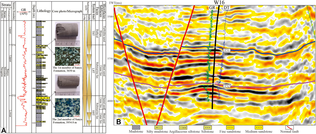
FIGURE 3. Response characteristics of submarine fan facies in drilling profile (A) and seismic profile (B). The submarine fan facies in the seismic profile shows continuous medium–low frequency and subparallel medium–strong amplitudes.
The delta facies presents S-shaped progradation or oblique progradation reflections on the seismic profile, with medium amplitude and good continuity. The delta facies of the lower Miocene Sanya Formation in the northern shelf of the Songnan and Baodao Sags is generally an oblique progradation reflection, which represents a progradation structure under shallow water conditions with a strong hydrodynamic force on a gentle slope. The delta facies in the shelf margin generally presents an S-shaped progradation reflection, which indicates a rapid increase in water depth and rapid unloading of sediments. Wells W11 and W12 encountered the delta deposits of the Sanya Formation. The logging curves are mainly funnel-shaped and bell-shaped, reflecting the estuary bar and underwater distributary channel deposits of the continental shelf delta front subfacies. Based on the lithological comparison of the drilled wells, deltas developed in the early and late stages of the Sanya Formation deposition on the narrow shelf of the northern Songnan Sag, and the fine sandstone content is high. Especially in the lowstand system tract of the first member of the Sanya Formation, large-scale fine sandstone delta facies is developed on the shelf edge, which is conducive to the development of sandstone reservoirs in deep water (Figure 4).
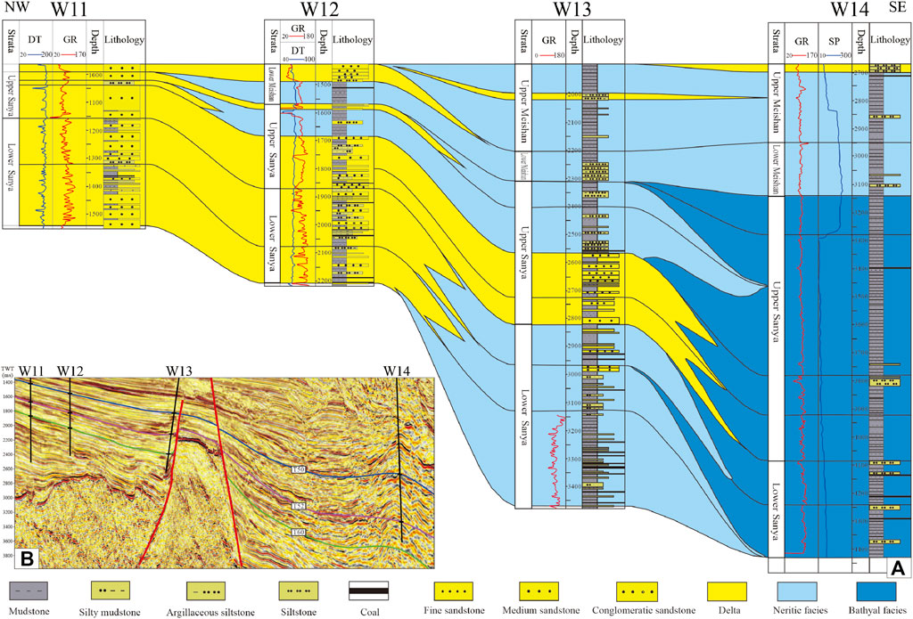
FIGURE 4. Cross-well facies profile (A) and corresponding seismic profile (B) of the lower Miocene Sanya Formation in the northern Songnan Sag, showing the characteristics of logging and seismic data of delta, littoral, and bathyal facies on the continental shelf margin.
The littoral facies shows medium and weak amplitudes, medium frequencies, poor continuity, and subparallel or wavy reflections on the seismic profile, indicating a certain amount of water turbulence. The seismic reflections of neritic facies are characterized by medium–high frequencies, medium–strong amplitudes, and parallel continuous reflections, which indicate a relatively stable sedimentary environment. Well W13 is mainly composed of a large set of gray mudstones mixed with argillaceous siltstone, which likely represents neritic facies deposition, based on combined lithological and paleontological data. The bathyal facies presents medium-to-low frequencies, medium-to-weak amplitudes, and continuous parallel seismic reflections, indicating a stable deepwater mud-rich sedimentary environment. Well W14 is mainly composed of a large set of gray mudstones, which is likely a bathyal facies deposit, according to combined lithological and paleontological data.
In the Miocene in the Qiongdongnan Basin, shelf breaks began to develop in the northern continental margin of the Central Depression against the gentle slope sedimentary background due to differences in subsidence and sedimentation. On the seismic profile, the sedimentary strata in the continental shelf area are gentle and have a low gradient, while the gradient of the sedimentary strata in the continental slope is relatively large. Therefore, the abrupt change point of the strata gradient is determined as the slope break point. We identified a series of shelf break points and connected them, forming a line called the shelf break belt of the Songnan, Baodao, and Changchang Sags. During the early Miocene sedimentary period, the shelf break belt was located along the northern edge of the Songnan and Baodao Sags in a southwest‒northeast trend. The shelf break obviously migrated into the sag from the early stage to the late stage of the early Miocene (Figure 5). Shelf marginal deltas generally develop above the shelf break belt, and submarine fan systems may have developed below the shelf break belt.

FIGURE 5. Shelf break belt on the continental shelf margin in the early Miocene in the eastern deepwater area of the QB. The abrupt change point of the strata gradient is defined as the shelf break point (A), and the shelf breakpoints are connected into a line, which is the shelf break belt (B).
In the early stage of the early Miocene, bathyal facies developed in the Songnan, Baodao, and Changchang Sags of the QB; littoral and neritic facies were widely developed in the Songtao Uplift, Songdong Sag, and Songxi Sag; and extensive littoral facies developed in the Shenhu Uplift. Four delta depositional systems developed in the northern shelf area of the Songnan, Baodao, and Changchang Sags. The delta was large, greater than 800 km2. Canyon–submarine fan depositional systems were widely developed in the deepwater area at the fronts of the deltas. Among them, the northern delta of the Songnan Sag was connected with the Hainan Uplift, and the delta facies present typical oblique progradation reflection characteristics (Figure 6). The area (km2)/thickness (ms) ratios of submarine fans developed on the northern steep slope of the Songnan and Baodao Sags are generally less than 2, and the thicknesses and areas of submarine fans are large and small, respectively. However, the submarine fans in the southern margin of the Changchang Sag and Baodao Sag located on the gentle slope had large areas and small thicknesses, and the area (km2)/thickness (ms) ratios are generally greater than 4.
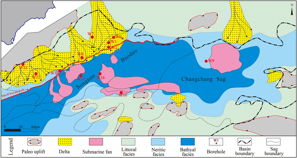
FIGURE 6. Sedimentary facies of the early stage of the lower Miocene strata (the second member of the Sanya Formation) in the eastern deepwater area of the Qiongdongnan Basin.
In the late stage of the early Miocene, the Songnan, Baodao, and Changchang Sags in the QB basically inherited the early sedimentary pattern, but the sedimentary range of the bathyal facies was further expanded, and the littoral facies was reduced. Due to the rapid decline in sea level in the late stage of the early Miocene and the increase in provenance supply on Hainan Island, longitudinally superimposed canyon–submarine fan complex deposits developed in the Songnan Sag under the continuous supply of two large deltas in the north; the complex deposits are generally lenticular and have continuous medium–strong amplitude reflections; two deltas with a combined area of more than 3,000 km2 formed in the northern Baodao Sag. The front edge of the western delta partially crossed the shelf break, forming two submarine fans with a combined area of nearly 800 km2 in the sag. The eastern delta was located in the shelf area, and the front-end submarine fan did not develop. Two large-scale submarine fans developed in the middle of the Changchang Sag, with a total area of approximately 1,100 km2, showing parallel continuous reflections of medium frequency and medium–strong amplitude on the seismic profile, and the fans pinched out to bathyal facies mudstone (parallel continuous reflections of medium–low frequency and medium and weak amplitude). It is speculated that it was a submarine fan system that formed under the influence of ocean currents and was located along the axis of the Changchang Sag (Figure 7). Similar to the early stage of the lower Miocene sedimentary strata, the area (km2)/thickness (ms) ratio of the submarine fan located in the steep slope area was small, while the area (km2)/thickness (ms) ratio of the submarine fan in the gentle slope area was large.
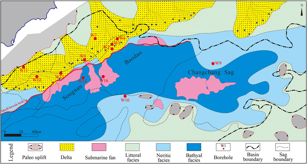
FIGURE 7. Late-stage sedimentary facies of the lower Miocene strata (the first member of the Sanya Formation) in the eastern deepwater area of the Qiongdongnan Basin.
Paleo-submarine landforms have an important influence on the plane distribution of the delta–submarine fan depositional system; this influence is mainly indicated by the influence of continental shelf landforms on the plane distribution of the delta sedimentary system and its seaward prograding distance, the type of slope break zone and the slope gradient on the scale and sedimentary structure of submarine canyons and submarine fans, and the influence of basin submarine landforms on the distribution of submarine fan depositional systems.
In the early stage of the early Miocene, uplift areas developed on both the northern and southern sides of the Songnan, Baodao, and Changchang Sags, confirming the existence of two large provenance zones in the north and south (Figure 8A). The northern provenance zone was mainly located in the Hainan Uplift in the northern Songxi Sag and a local uplift within the Shenhu Uplift in the northern Baodao and Changchang Sags; the zone had a large provenance area and planar distribution. The southern provenance area was mainly a local uplift within the southern uplift, and single-provenance areas were small and scattered. At the same time, a wide and gentle continental shelf developed in the northern Songnan, Baodao, and Changchang Sags, and the seawater depth was shallow, which was conducive to the long-distance transport of sediments and provided favorable conditions for the development of a large delta–submarine fan depositional system in the Songnan, Baodao, and Changchang Sags. In the early stage of the early Miocene, the Baodao and Changchang Sags were the sedimentary centers of the eastern section of the QB. The Baodao and Changchang Sags developed an east‒west-trending and southeast-trending depression zone, and the slope break zone was located in a nearly east‒west-trending zone. Together with the uplift in the northwestern Baodao Sag and the northern Changchang Sag, the development position and distribution direction of sedimentary systems, such as deltas and submarine fans, in the sag were determined.
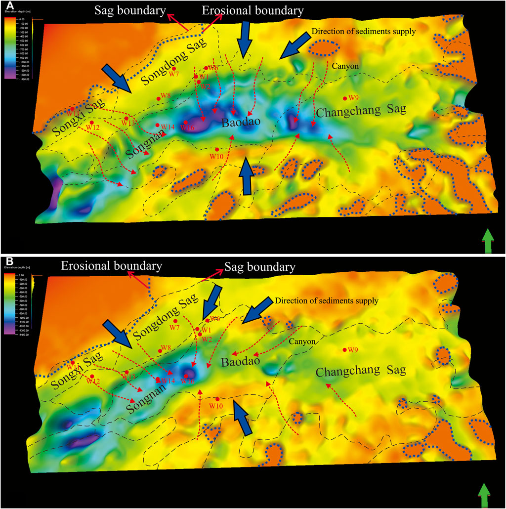
FIGURE 8. Paleogeomorphic map of the lower Miocene sedimentary period in the eastern deepwater area of the Qiongdongnan Basin. (A) shows the paleogeomorphic map of the early stage of the lower Miocene strata (the second member of the Sanya Formation), and (B) shows the paleogeomorphic map of the late stage of the lower Miocene strata (the first member of the Sanya Formation).
In the late stage of the early Miocene, the exposed area of the northern uplift area increased compared with that in the early stage, which reduced the area of the northern shelf of the Songnan, Baodao, and Changchang Sags; however, it still maintained gentle geomorphic characteristics, which was more conducive to the transport of sediments to the continental slope basin bottom (Figure 8B). The paleogeomorphic map shows that the early sedimentary center of the eastern section of the QB moved westward from the Baodao and Changchang Sags to the Songnan and Baodao Sags. The sedimentation rate of the Changchang Sag decreased significantly, and the distribution of the slope break zone also shifted to a nearly southwest‒northeast trend. This transformation may be related to the increase in the outcrop area in the Hainan Uplift, which determines the number and distribution of submarine fans in the Songnan and Baodao Sags.
Previous studies have shown that Hainan Island, the Red River, Central Vietnam, and the Southern Uplift are four potential provenance areas in the QB. The analytical results of heavy mineral data from the lower Miocene strata in wells W2, W6, W7, W9, and W10 in the Songnan, Baodao, and Changchang Sags (well locations are shown in Figure 1) indicate that the heavy mineral assemblage from the northern part of the Songnan Sag in the lower Miocene strata consists of magnetite + hematite–limonite + leucosphenite and is characterized by the high proportion of leucosphenite; the drilling result reveals that the heavy mineral assemblage from the northern part of the Baodao Sag in the lower Miocene strata consists of leucosphenite + magnetite + hematite–limonite and is characterized by a high proportion of hematite–limonite; drilling in the Changchang Sag reveals that the heavy mineral assemblage of the sag in the lower Miocene strata consists of zircon + magnetite + hematite–limonite; well W10 in the southern margin of the Baodao Sag reveals that the heavy mineral assemblage of the sag in the lower Miocene strata has a typical characteristic high proportion of leucosphenite (Figure 9). This heavy mineral assemblage is basically consistent with the heavy mineral assemblage (ilmenite + zircon) of the parent rock from Hainan Island. However, the heavy mineral assemblage of the sag is different from the heavy mineral assemblages from the estuary of the Red River (magnetite + ilmenite + garnet + hematite–limonite + epidote + hornblende) and central Vietnam (zircon + tourmaline + rutile + leucosphenite + ilmenite + apatite). Cao et al., 2015 analyzed the plane distribution of the stable heavy minerals in the lower Miocene strata of the Songnan and Baodao Sags via the heavy mineral ZTR index; their analysis indicates that the provenance of the Songnan and Baodao Sags in the lower Miocene was mainly from the Hainan Uplift, and part of an area of the sag was also possibly affected by volcanic activity. This study shows that the provenance area of Hainan Island can also be divided into three provenance areas that exist in the western area (north of Songnan Sag), central area (north of Baodao Sag), and eastern area (north of Changchang Sag). In summary, during the sedimentary period of the early Miocene, four provenance areas existed in the northern and southern belts of the Songnan, Baodao, and Changchang Sags of the QB. The western provenance and central provenance mainly controlled the distribution of the delta–canyon–submarine fan system in the sag.
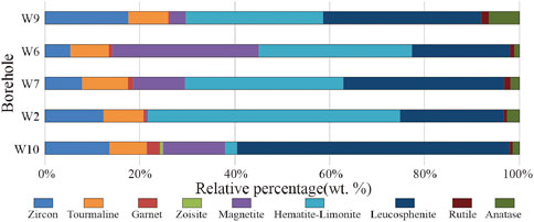
FIGURE 9. Heavy mineral assemblage of the lower Miocene Sanya Formation in the eastern deepwater area of the Qiongdongnan Basin; the well locations are shown in Figure 1.
The average REE content of the lower Miocene sandstone samples acquired from wells W7, W6, and W2 in the northern Songnan and Baodao Sags is 162.15, and the average La/Yb ratio is 8.95 (well locations are shown in Figure 1). The light rare earth elements (LREEs) are of relative enrichment, the average ΣLREE/ΣHREE ratio is 8.25, and the average La/Sm ratio is 3.67. The distribution of heavy rare earth elements (HREEs) is relatively flat; the average Gd/Yb ratio is 1.95, and the average Gd/Lu ratio is 2.09. The Eu anomaly appears to be negative. The average δEu is 0.72, the Ce anomaly is not apparent, and the average δCe is 1.06.
Comparing the three potential provenances, the LREEs of sediments from the Red River are of relative enrichment, while Eu and Ce are of relative depletion (δCe is 0.49 and δEu is 0.57); Gd, Tb, Dy, and Tm are of relative enrichment in the HREEs. In Central Vietnam, the Eu anomaly in the provenance area is apparently negative, δEu is 0.58, and the LREEs are of relative enrichment; the ΣLREE/ΣHREE ratio is 10.68, the La/Sm ratio is 5.42, the HREEs are relatively flat, and the Gd/Yb and Gd/Lu ratios are both low, with values of 1.18 and 1.23, respectively. On Hainan Island, LREEs are also of relative enrichment, ΣLREE/ΣHREE ratios are within 10.74–13.64, La/Sm ratios are within 3.11–5.24, HREEs are relatively flat, and Gd/Yb and Gd/Lu ratios are within 1.70–2.72 and 1.76–1.82, respectively. Combined with the REE distribution patterns, the REE distribution patterns of the lower Miocene sandstone samples from wells W7, W6 and W2 are similar to those of Hainan Island (Figure 10).
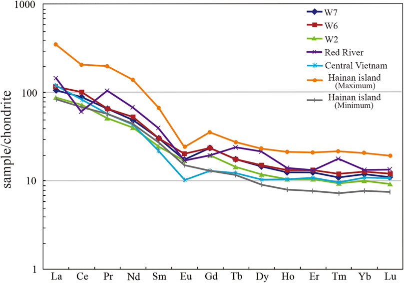
FIGURE 10. REE distribution of the lower Miocene strata in the eastern deepwater area of the Qiongdongnan Basin. Data on sediments in Hainan Island were derived from Shao et al., 2010, data on sediments in the Red River were derived from Wang et al., 2011 and Zhao et al., 2015a, and data on sediments in Central Vietnam were derived from Cao et al., 2015.
Submarine canyons are the main channels by which gravity flows transport continental shelf sediments to the deep-sea plain (Babonneau et al., 2013; Gales et al., 2014; Martín-Merino et al., 2014; Pickering et al., 2015), and they are the intermediate link in the source-to-sink system on the continental margin (Parra et al., 2012; Matenco and Andriessen, 2013; Prizomwala et al., 2014; Bentley et al., 2016). The scale of development and shape of the distribution of submarine canyons, as well as the distance and connection characteristics between the head and the source area, have an important impact on the scale, spatial distribution, and sand-bearing properties of submarine fan depositional systems.
In the early stage of the early Miocene, a series of submarine canyons developed on the northern shelf margin of the Songnan and Baodao Sags, and they showed typical downward-cutting erosion and internal two-way upward-filling deposition on the seismic profile. Longitudinally, the scale of canyon development in the early stage of the early Miocene was larger than that in the late stage (Figure 11). The variance attribute is a kind of temporal seismic attribute that uses the similarity between adjacent signals to describe the heterogeneity of strata and lithology and reflects the discontinuous information in the data volume, which can be used to identify the appearance of submarine canyons. The variance seismic attribute map shows that the scale of the canyon system decreases from bottom to top in the lower Miocene strata (Figure 12), and these canyons controlled the distribution of the submarine fan system in the early Miocene, especially in the early stage of the early Miocene.
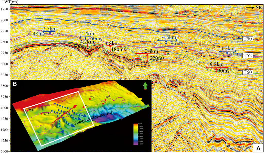
FIGURE 11. Seismic reflection characteristics of the canyons in the lower Miocene Sanya Formation in the northern Songnan Sag (A). The widths of the canyons in the early stage of the early Miocene were 4.2–7.6 km, and the heights were 60–220 ms. The widths of the canyons in the late stage of the early Miocene were 2.2–4.8 km, and the heights were 48–96 ms. The scale of the canyons in the early stage of the early Miocene is significantly larger than that in the late stage of the early Miocene. (B) shows the paleogeomorphic map of the early stage of the early Miocene.
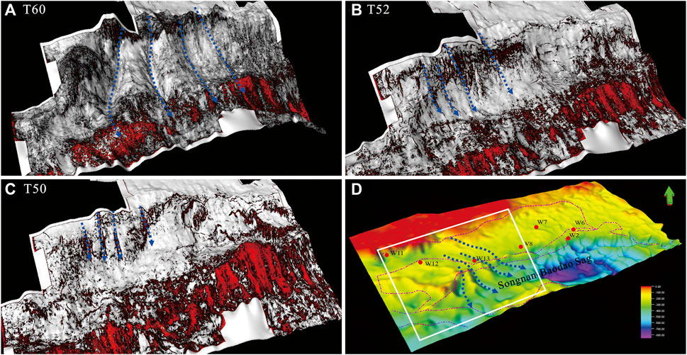
FIGURE 12. Seismic variance attribute map of canyons in the lower Miocene Sanya Formation in the northern Songnan Sag. (A) is the variance attribute map of the T60 interface, (B) is the variance attribute map of the T52 interface, (C) is the variance attribute map of the T50 interface, and (D) is the paleogeomorphic map of the early stage of the early Miocene.
The submarine fan–channel complexes developed in the lower Miocene Sanya Formation of the Songnan Sag. The submarine fan facies are characterized by lenticular medium–continuous variable-amplitude seismic reflections, and the channel facies shows bidirectional upwelling and medium–continuous medium–strong-amplitude seismic reflections (Figures 13A,B). The submarine fan facies were mainly deposited in the Baodao Sag, and they are characterized by lenticular medium–good continuous medium–strong-amplitude seismic reflections (Figures 13C,D). The root mean square (RMS) amplitude seismic attribute is used to square the average value of the square of the amplitude to indicate the average change level of the amplitude. It is sensitive to strong amplitudes and can distinguish lithological characteristics, which can be used to assist in identifying submarine fan sand bodies. The RMS amplitude seismic attribute shows the general horizontal distribution range of the submarine fans (Figures 13E,F). In addition, the seismic profile clearly shows that sediment transport channels (Figures 13G,H) and some canyons are inherited and developed. Based on the abovementioned source-to-sink analysis, the horizontal distribution range of submarine fans in the lower Miocene Sanya Formation of the Songnan Sag is depicted. The research methods of other submarine fans in the study area are similar.
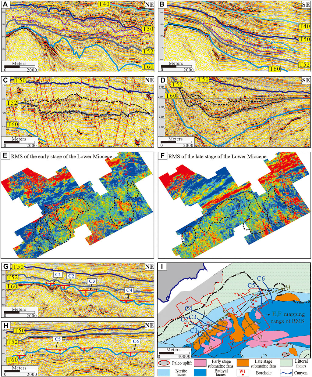
FIGURE 13. Seismic profile and RMS seismic attribute map of the submarine fans in the lower Miocene Sanya Formation. (A) and (B) are the seismic profiles of the submarine fans passing through the Songnan Sag on the west side in the direction of the vertical source and along the direction of the source, respectively. (C,D) are the seismic profiles of the submarine fans passing through the Baodao Sag on the east side in the direction of the vertical source and along the direction of the source, respectively. (E,F) are the RMS seismic attribute maps of the early and late stages of the early Miocene, respectively; (G,H) show the sediment transport channels at the upper end of the submarine fans on the east and west, respectively; and (I) shows the horizontal distribution of the submarine fans.
The Songnan, Baodao, and Changchang Sags in the QB developed a north–south dual provenance in the early Miocene, and the Hainan Uplift that developed in the northern part of the sag is the main provenance area. The sediments from the Hainan Uplift formed multiple deltas in the gentle continental shelf of the northern Songnan and Baodao Sags. The source of the sediments was close to the continental shelf; multiple submarine canyons developed at the continental shelf margin. Gravity flows transported the delta front sediments at the continental shelf margin to the inside of the Songnan and Baodao Sags through submarine canyons, and several submarine fans of different scales were formed. This article summarizes the source-to-sink model of the lower Miocene submarine fans in the Songnan, Baodao, and Changchang Sags, Qiongdongnan Basin, as shown in Figure 14.
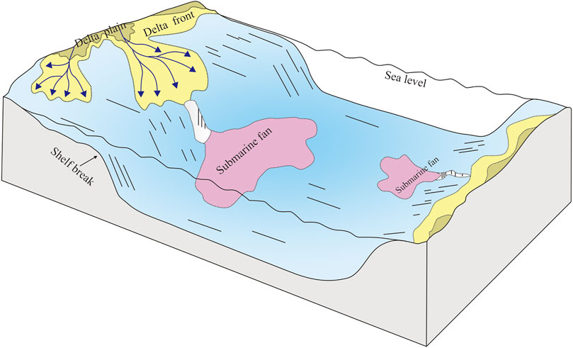
FIGURE 14. Depositional model of submarine fans in the eastern deepwater area of the Qiongdongnan Basin.
From the perspective of the source-to-sink system, this study analyzes the lower Miocene provenance systems and sediment dispersion systems in the eastern section of the deepwater area of the Qiongdongnan Basin in the northern South China Sea; defines the provenance supply, paleogeomorphology and sediment transport system, sedimentation results and distribution; and comprehensively constructs a set of source-to-sink system research methods. Based on factors such as provenance area, sand-bearing properties of deltas, continental shelf width, and connectivity between canyons and deltas, this study believes that the Songnan Sag in the eastern deepwater area of the Qiongdongnan Basin is a favorable area for the development of submarine fan facies in the Sanya Formation. The Songnan Sag has high hydrocarbon generation intensity. Miocene submarine fans are mostly located in the sag and above mature source rocks, and the reservoir formation conditions are good. This study recommends focusing on the main parts of large-scale submarine fans in the early stage of exploration, and main channel drilling is preferred.
Based on the source-to-sink analysis of submarine fans developed in the Sanya Formation of the Songnan, Baodao, and Changchang Sags, the results can be concluded as follows.
1) In the eastern deepwater area of the lower Miocene strata in the Qiongdongnan Basin, uplift areas developed on both the northern and southern sides of the Songnan, Baodao, and Changchang Sags, in which the southern part of the sag is a small provenance near-concave uplift; the provenance area in the northern part of the sag is large, but the provenance direction is different, which resulted in different provenance systems, including the Hainan Uplift in the northern Songnan Sag, the Hainan Uplift in the northern Baodao Sag, and the Shenhu Uplift in the northern Changchang Sag.
2) During the sedimentary period of the early Miocene, a series of canyons developed in the Songnan, Baodao, and Changchang Sags of the QB and were the primary channels for sediment transport from the shelf to slope. During the early stage of the early Miocene, the size of the canyons was larger due to the descending regional sea level, while the size of the canyons was smaller during the late stage of the early Miocene.
3) Under the control of multiple provenance areas, multiple delta–canyon–submarine fan depositional systems developed in the Songnan, Baodao, and Changchang Sags of the QB. The large deltas were distributed along the northern part of the sag and were deposited to the edge of the shelf of the Songnan, Baodao, and Changchang Sags from north to south, which provided a good material basis for the development of deepwater sediments. The deepwater sedimentary deposits in the steep slope area of the northern Songnan, Baodao, and Changchang Sags are mainly canyon–submarine fan complex deposits, while submarine fan facies are mainly developed in the gentle slope and central part of the sag.
The original contributions presented in the study are included in the article/Supplementary Material; further inquiries can be directed to the corresponding author.
Methodology and writing—original draft preparation, RS; supervision, ZS; investigation, XY and XW; visualization and formal analysis, KW, YH, JX, HY, HL, and QZ; writing—review and editing, RS and ZS.
The present research was funded by the National Science and Technology Major Project of the Ministry of Science and Technology of China, grant number 2016ZX05026-007.
We thank the CNOOC for providing core samples and necessary data.
RS, KW, JX, HY, HL and QZ are employed by CNOOC. XW is employed by PetroChina. YH was employed by XDEC Mudlogging Branch Company.
The remaining authors declare that the research was conducted in the absence of any commercial or financial relationships that could be construed as a potential conflict of interest.
All claims expressed in this article are solely those of the authors and do not necessarily represent those of their affiliated organizations, or those of the publisher, the editors, and the reviewers. Any product that may be evaluated in this article, or claim that may be made by its manufacturer, is not guaranteed or endorsed by the publisher.
Babonneau, N., Delacourt, C., Cancouët, R., Sisavath, E., Bachèlery, P., Mazuel, A., et al. (2013). Direct sediment transfer from land to deep-sea: Insights into shallow multibeam bathymetry at La Réunion Island. Mar. Geol. 346, 47–57. doi:10.1016/j.margeo.2013.08.006
Bentley, S. J., Blum, M. D., Maloney, J., Pomd, L., and Paulsell, R. (2016). The Mississippi River source-to-sink system: Perspectives on tectonic, climatic, and anthropogenic influences, Miocene to Anthropocene. Earth. Sci. Rev. 153, 139–174. doi:10.1016/j.earscirev.2015.11.001
Cao, L. C., Jiang, T., Wang, Z. F., Zhang, Y. Z., and Sun, H. (2015). Provenance of upper Miocene sediments in the Yinggehai and qiongdongnan basins, northwestern south China sea: Evidence from REE, heavy minerals and zircon U–Pb ages. Mar. Geol. 361, 136–146. doi:10.1016/j.margeo.2015.01.007
Franke, D., Savva, D., Pubellier, M., Steuer, S., Mouly, B., Auxietre, J.-L., et al. (2014). The final rifting evolution in the South China Sea. Mar. Petroleum Geol. 58, 704–720. doi:10.1016/j.marpetgeo.2013.11.020
Gales, J. A., Leat, P. T., Larter, R. D., Kuhn, G., Hillenbrand, C. D., Graham, A. G. C., et al. (2014). Large-scale submarine landslides, channel and gully systems on the southern Weddell Sea margin, Antarctica. Mar. Geol. 348, 73–87. doi:10.1016/j.margeo.2013.12.002
Gong, C. L., Wang, Y. M., Hodgson, D. M., Zhu, W. L., Li, W. G., Xu, Q., et al. (2014). Origin and anatomy of two different types of mass–transport complexes: A 3D seismic case study from the northern South China sea margin. Mar. Petroleum Geol. 54, 198–215. doi:10.1016/j.marpetgeo.2014.03.006
Hu, B., Wang, L. S., Yan, W. B., Liu, S. W., Cai, D. S., Zhang, G. C., et al. (2013). The tectonic evolution of the Qiongdongnan Basin in the northern margin of the South China Sea. J. Asian Earth Sci. 77, 163–182. doi:10.1016/j.jseaes.2013.08.022
Huang, B. J., Wang, Z. F., and Liang, G. (2014). Natural gas source and migration-accumulation pattern in the central canyon, the deep-water area. Qiongdongnan basin. China Offshore Oil Gas 26 (5), 8–14.
Hui, G. G., Li, S. Z., Guo, L. L., Zhang, G. X., Gong, Y. H., Somerville, I. D., et al. (2016). Source and accumulation of gas hydrate in the northern margin of the South China Sea. Mar. Petroleum Geol. 69, 127–145. doi:10.1016/j.marpetgeo.2015.10.009
Lei, C., Ren, J. Y., Li, X. S., Tong, C. X., Yin, X. Y., and Min, H. (2011). Structural characteristics and petroleum exploration potential in the deep-water area of the Qiongdongnan Basin, South China Sea. Petroleum Explor. Dev. 38 (5), 560–569.
Li, X. X., Zhong, Z. H., Dong, W. L., Sun, Z., Wang, L. S., Xia, B., et al. (2006). Paleogene rift structure and its dynamics of Qiongdongnan Basin. Petroleum Explor. Dev. 33 (6), 713–721. doi:10.3321/j.issn:1000-0747.2006.06.014
Lin, C. S., Xia, Q. L., Shi, H. S., and Zhou, X. H. (2015). Carvedilol use is associated with reduced cancer risk: A nationwide population-based cohort study. Int. J. Cardiol. 22 (1), 9–13. doi:10.1016/j.ijcard.2015.02.015
Martín-Merino, G., Fernández, L. P., Colmenero, J. R., and Bahamonde, J. R. (2014). Mass-transport deposits in a Variscan wedge-top foreland basin (Pisuerga area, Cantabrian Zone, NW Spain). Mar. Geol. 356, 71–87. doi:10.1016/j.margeo.2014.01.012
Martinsen, O. J., Lien, T., and Jackson, C. (2005). Cretaceous and Palaeogene turbidite systems in the North Sea and Norwegian Sea Basins: Source, staging area and basin physiography controls on reservoir development. Pet. Geol. Conf. Ser. 6, 1147–1164. doi:10.1144/0061147
Martinsen, O. J., Somme, T. O., Thurmond, J. B., Hanse, W. H., and Lunt, I. (2010). Source-to-sink systems on passive margins: Theory and practice with an example from the Norwegian continental margin. Pet. Geol. Conf. 7, 913–920. doi:10.1144/0070913
Matenco, L., and Andriessen, P. (2013). Quantifying the mass transfer from mountain ranges to deposition in sedimentary basins: Source to sink studies in the Danube Basin-Black Sea system. Glob. Planet. Change 103, 1–18. doi:10.1016/j.gloplacha.2013.01.003
Morley, C. K. (2016). Major unconformities/termination of extension events and associated surfaces in the South China Seas: Review and implications for tectonic development. J. Asian Earth Sci. 120, 62–86. doi:10.1016/j.jseaes.2016.01.013
Pang, X., Peng, D. J., Chen, C. M., Zhu, M., He, M., and Shen, J. (2007). Three hierarchies "Source-Conduit-Sink" coupling analysis of the Pearl River deep-water fan system. Acta Geol. Sin. 81 (6), 857–864. doi:10.3321/j.issn:0001-5717.2007.06.016
Pang, X., Shen, J., Yuan, L. Z., Lian, S., and Shu, Y. (2006). Petroleum prospect in deep-water fan system of the Pearl riverin the south China sea. Acta Pet. Sin. 27 (3), 11–15. doi:10.3321/j.issn:0253-2697.2006.03.003
Parra, J. G., Marsaglis, K. M., Rivera, K. S., Dawson, S. T., and Walsh, J. P. (2012). Provenance of sand on the Poverty Bay shelf, the link between source and sink sectors of the Waipaoa River sedimentary system. Sediment. Geol. 280, 208–233. doi:10.1016/j.sedgeo.2012.04.012
Pickering, K. T., Corregidor, J., and Clark, J. D. (2015). Architecture and stacking patterns of lower-slope and proximal basin-floor channelised submarine fans, Middle Eocene Ainsa System, Spanish Pyrenees: An integrated outcrop-subsurface study. Earth. Sci. Rev. 144, 47–81. doi:10.1016/j.earscirev.2014.11.017
Prizomwala, S. P., Bhatt, N., and Basavaiah, N. (2014). Provenance discrimination and Source-to-Sink studies from a dryland fluvial regime: An example from Kachchh, Western India. Int. J. Sediment Res. 29 (1), 99–109. doi:10.1016/s1001-6279(14)60025-1
Shao, L., Li, A., Wu, G. X., Li, Q. Y., Liu, C. L., and Qiao, P. J. (2010). Evolution of sedimentary environment and provenance in Qiongdongnan Basin in the north south China sea. Acta Pet. Sin. 31 (4), 548–552. (in Chinese with English abstract). doi:10.7623/syxb201004005
Stow, D. A. V., and Mayall, M. (2000). Deep-water sedimentary systems: New models for the 21st century. Mar. Petroleum Geol. 17 (2), 125–135. doi:10.1016/s0264-8172(99)00064-1
Su, L., Zheng, J. J., Chen, G. J., Zhang, G. C., Guo, J. M., and Xu, Y. C. (2012). The upper limit of maturity of natural gas generation and its implication for the Yacheng formation in the Qiongdongnan Basin, China. J. Asian Earth Sci. 54 (55), 203–213. doi:10.1016/j.jseaes.2012.04.016
Sun, R., Han, Y. X., Zeng, Q. B., Wang, X. Y., Zhang, G. C., Zhang, Z. G., et al. (2019). Sedimentary characteristics of Yacheng Formation in the eastern deepwater area in Qiongdongnan Basin and their control on marine source rocks. Acta Pet. Sin. 40 (S2), 57–66. doi:10.7623/syxb2019S2006
Wang, D. W., Wu, S. G., Qin, Z. L., Spence, G., and Lü, F. L. (2013). Seismic characteristics of the Huaguang mass transport deposits in the Qiongdongnan Basin, South China Sea: Implications for regional tectonic activity. Mar. Geol. 346, 165–182. doi:10.1016/j.margeo.2013.09.003
Wang, D. W., Wu, S. G., Yao, G. S., and Wang, W. W. (2015b). Architecture and evolution of deep-water cyclic deposits in the Qiongdongnan Basin, south China sea: Relationship with the pleistocene climate events. Mar. Geol. 370, 43–54. doi:10.1016/j.margeo.2015.10.002
Wang, Y. F., Wang, Y. M., Li, D., and Xu, Q. (2011). Features and source analysis on early Pliocene sedimentary rare Earth element (REE) in Central Canyon of Qiongdongnan Basin. J. oil gas Technol. 13, 50–54. (in Chinese with English abstract). doi:10.3969/j.issn.1000-9752.2011.06.011
Wang, Z. F. (2012). Important deepwater hydrocarbon reservoirs: the Central Canyon system in the Qiongdongnan Basin. Acta Sedimentol. Sin. 30 (4), 646–653. doi:10.14027/j.cnki.cjxb.2012.04.002
Wang, Z. F., Sun, Z. P., Zhang, Y. Z., Guo, M., Zhu, J., Huang, B., et al. (2016). Distribution and hydrocarbon accumulation mechanism of the giant deep-water Central Canyon gas field in Qiongdongnan Basin, northern South China Sea. China Pet. Explor. 21 (4), 54–64. doi:10.3969/j.issn.1672-7703.2016.04.006
Wang, Z. F., Sun, Z. P., Zhu, J. T., Guo, M. G., and Jiang, R. F. (2015a). Natural gas geological characteristics and great discovery of large gas fields in deep-water area of the Western South China Sea. Nat. Gas. Ind. B B2, 489–498. doi:10.1016/j.ngib.2016.03.001
Xie, W. Y., Zhang, Y. W., Sun, Z., and Jiang, J. Q. (2007). Characteristics and formation mechanism of faults in Qiongdongnan Basin. Mar. Geol. Quat. Geol. 27 (1), 71–78. doi:10.16562/j.cnki.0256-1492.2007.01.009
Xie, W. Y., Zhang, Y. W., and Sun, Z. (2008a). The mechanism research of the formation of the Qiongdongnan basin during the Cenozoic through modeling experiments. Earth Sci. Front. 15 (2), 232–241. doi:10.1258/026835507780346150
Xie, Y. H., Fan, C. W., Zhou, J. X., Zhang, Y. Z., Tan, J. C., and Ren, K. Y. (2016). Sedimentary features and controlling factors of the gravity flows in submarine fan of Middle Miocene in the Qiongdongnan Basin. Nat. Gas. Geosci. 27 (2), 220–228. doi:10.11764/j.issn.1672-1926.2016.02.0220
Xie, Y. H., and Huang, B. J. (2014). Characteristics and accumulation mechanisms of the Dongfang 13-1 high temperature and overpressured gas field in the Yinggehai Basin, the South China Sea. Sci. China Earth Sci. 44 (8), 2799–2807. doi:10.1007/s11430-014-4934-0
Xie, Y. H. (2014). Significant breakthrough in proprietary deep-water natural gas exploration in the northern South China Sea and its inspiration. Nat. Gas. Ind. B B1, 221–229. doi:10.1016/j.ngib.2014.11.015
Xie, Y. H., Wang, Z. F., and Tong, C. X. (2008b). Petroleum geology of Yacheng 13-1, the largest gas field in China's offshore region. Mar. Petroleum Geol. 25, 433–444. doi:10.1016/j.marpetgeo.2008.01.006
Xu, C. G., Du, X. F., Xu, W., and Zhao, M. (2017). New advances of the “source-to sink” system research in sedimentary basin. Oil Gas Geol. 38 (1), 1–11. doi:10.11743/ogg20170101
Xu, H. Z., Zhang, Y. Z., Lin, C. M., Pei, J. X., and Liu, Y. (2014a). Characteristics and key controlling factors of natural gas accumulation in the Central Submarine Canyon, Qiongdongnan Basin. Acta Geol. Sin. 88 (9), 1741–1752. doi:10.3969/j.issn.0001-5717.2014.09.010
Xu, X. D., Zhang, Y. Z., and Pei, J. X. (2014b). Gas accumulating models and exploration stratergy for high quality natural gas in the Dongfang Area, Yinggehai Basin. Acta Geol. Sin. 88 (5), 956–965. doi:10.3969/j.issn.0001-5717.2014.05.012
Yu, J. F., Pei, J. X., and Xu, J. (2009). New insight into oil and gas exploration in Miocene and Late Oligocene strata in Qiongdongnan basin. J. Earth Sci. 20, 811–823. doi:10.1007/s12583-009-0055-7
Yuan, S. Q., Yao, G. S., Lü, F. L., Hu, B., He, X. S., Wang, B., et al. (2009). Features of late cenozoic deepwater sedimentation in southern Qiongdongnan Basin, northwestern South China Sea. J. Earth Sci. 20, 172–179. doi:10.1007/s12583-009-0017-0
Zhang, G. C., Mi, L. J., Wu, S. G., Tao, W. X., He, S. B., and Lü, J. J. (2007). Deepwater area-the new prospecting targets of northern continental margin of South China Sea. Acta Pet. Sin. 28 (2), 15–21. doi:10.3321/j.issn:0253-2697.2007.02.003
Zhang, G. C., Qu, H. J., Liu, S. X., Xie, X. J., Zhao, Z., and Shen, H. L. (2015). Tectonic cycle of marginal sea controlled the hydrocarbon accumulation in deep-water areas of South China Sea. Acta Pet. Sin. 36 (5), 533–545. doi:10.7623/syxb201505002
Zhang, G. C., Zhang, Y. N., Shen, H. L., and He, Y. (2014). An analysis of natural gas exploration potential in the Qiongdongnan Basin by use of the theory of joint control of source rock and geothermal heat. Nat. Gas. Ind. 34 (1), 18–27. doi:10.3787/j.issn.1000-0976.2014.01.003
Zhao, M., Shao, L., Liang, J. S., and Li, Q. Y. (2015a). No Red River capture since the late Oligocene: Geochemical evidence from the northwestern south China sea. Deep Sea Res. Part II Top. Stud. Oceanogr. 122, 185–194. doi:10.1016/j.dsr2.2015.02.029
Zhao, Z. X., Sun, Z., Wang, Z. F., Sun, Z. P., Liu, J. B., and Zhang, C. M. (2015b). The high resolution sedimentary filling in Qiongdongnan Basin, northern South China sea. Mar. Geol. 361, 11–24. doi:10.1016/j.margeo.2015.01.002
Keywords: lower Miocene, submarine fan, source-to-sink system, Qiongdongnan Basin, South China Sea
Citation: Sun R, Yao X, Wang X, Wu K, Han Y, Xu J, Yang H, Li H, Zeng Q and Song Z (2022) Source-to-sink system and sedimentary characteristics of the lower Miocene submarine fans in the eastern deepwater area of the Qiongdongnan Basin, northern South China Sea. Front. Earth Sci. 10:956594. doi: 10.3389/feart.2022.956594
Received: 30 May 2022; Accepted: 25 July 2022;
Published: 30 August 2022.
Edited by:
Chen Zhang, Chengdu University of Technology, ChinaReviewed by:
Zengxue Li, Shandong University of Science and Technology, ChinaCopyright © 2022 Sun, Yao, Wang, Wu, Han, Xu, Yang, Li, Zeng and Song. This is an open-access article distributed under the terms of the Creative Commons Attribution License (CC BY). The use, distribution or reproduction in other forums is permitted, provided the original author(s) and the copyright owner(s) are credited and that the original publication in this journal is cited, in accordance with accepted academic practice. No use, distribution or reproduction is permitted which does not comply with these terms.
*Correspondence: Zezhang Song, c29uZ3p6QGN1cC5lZHUuY24=
Disclaimer: All claims expressed in this article are solely those of the authors and do not necessarily represent those of their affiliated organizations, or those of the publisher, the editors and the reviewers. Any product that may be evaluated in this article or claim that may be made by its manufacturer is not guaranteed or endorsed by the publisher.
Research integrity at Frontiers
Learn more about the work of our research integrity team to safeguard the quality of each article we publish.