 Fei Jiang
 Guang Fu1
- 1School of Earth Sciences, Northeast Petroleum University, Daqing, China
- 2PetroChina Dagang Oilfield Company, Tianjin, China
Oil-source faults play an important role in controlling hydrocarbon accumulation, and traps near these faults are often the most favorable positions for hydrocarbon accumulation. However, not all nearby traps can accumulate oil and gas. Therefore, it is necessary to predict favorable positions of hydrocarbon accumulation controlled by oil-source faults. Based on the analysis of hydrocarbon accumulation patterns near oil-source faults, a new method coupling hydrocarbon transportation positions of oil-source faults and favorable traps to predict favorable hydrocarbon accumulation positions is proposed. In this method, the hydrocarbon transportation positions are identified by the paleo activity rate during the hydrocarbon accumulation period; the favorable traps are identified by superimposing the position of fault traps, the lateral sealing position of faults, and the distribution of sand bodies with the ability to store oil and gas. Finally, the sites of overlap between the hydrocarbon transportation positions and the favorable traps are regarded as favorable positions for hydrocarbon accumulation under the control of oil-source faults. This method is applied to predict the favorable positions of hydrocarbon accumulation in the Ban 2 oil group of the Shahejie Formation near the Dazhangtuo fault, in the Qikou Sag (Bohai Bay Basin, East China). The results showed that the favorable positions of oil and gas accumulation along the Dazhangtuo fault in the Ban 2 oil group are mainly distributed in the northeast and center of the fault, and match well with the locations of the discovered oil and gas. Therefore, this method is useful to predict favorable hydrocarbon accumulation positions controlled by oil-source faults.
Introduction
Hydrocarbon exploration practice shows that oil-source faults play an important role in controlling hydrocarbon migration and accumulation in the accumulation model of “lower-generation and upper-storage” (Hooper, 1991; Aydin, 2000; Zeng and Jin, 2003; Luo, 2010; Fossen and Rotevatn, 2016; Fu et al., 2019; Zhang and Fu, 2022). On the one hand, oil-source faults are the main pathways for vertical hydrocarbon migration (Hooper, 1991; Losh, 1998; Goldsworthy and Jackson, 2001; Luo, 2010; Jiang et al., 2018; Fu et al., 2021). On the other hand, fault activities not only form fault-associated traps but also break rocks to form fractures that can provide storage space for oil and gas (Schlische, 1995; Jackson et al., 2006; Gong et al., 2019; Zeng et al., 2022). Therefore, traps near oil-source faults are often the most favorable positions for hydrocarbon accumulation. However, influenced by the differences in geological conditions, such as fault transportation capacity (Hooper, 1991; Jiang et al., 2018; Fu et al., 2019), reservoir distribution (Luo et al., 2012; Zhou et al., 2019; Liu et al., 2020; Gong et al., 2021a), and fault lateral sealing ability (Zhang et al., 2010; Lyu et al., 2021), not all traps near the same oil-source fault can accumulate oil and gas, only some traps can form oil and gas reservoirs. Therefore, predicting favorable positions for hydrocarbon accumulation controlled by oil-source faults is necessary and has an important guiding significance for the hydrocarbon exploration of the accumulation model of “lower-generation and upper-storage.”
Regarding the controlling effect of oil-source faults on hydrocarbon accumulation and distribution, there have been many studies on faults transporting hydrocarbons (Aydin, 2000; Fu and Wang, 2019; Cong et al., 2020; Liang et al., 2022), fault zone structures (Allan, 1989; Bense, et al., 2003; Zhang et al., 2022), fault lateral sealing ability (Chen et al., 2010; Fossen and Rotevatn, 2016; Lyu et al., 2016), source-fault configurations (Song et al., 2019; Zhang et al., 2022), fault-sand configurations (Fu et al., 2019; Zhou et al., 2019; Luo et al., 2020), fault-caprock configurations (Kumar et al., 2019; Shi et al., 2019; Wang et al., 2021), the development degree of sand bodies (Luo et al., 2012; Fu and Yu, 2021), fault trap characteristics (Jackson et al., 2006; Hu and Lyu, 2019; Song et al., 2020), etc., many studies have confirmed that the hydrocarbon accumulation position near an oil-source fault is related to the transportation capacity of the oil source fault (Lampe et al., 2012; Jiang et al., 2017; Liu et al., 2017; Fu and Wang, 2018). Not all parts of an oil-source fault can vertically migrate hydrocarbon and there are dominant migration conduits. Sites with relatively high fault activity rates are conducive to the transportation of hydrocarbons and favorable locations for fault-controlled hydrocarbon accumulation (Jiang et al., 2018; Cong et al., 2020; Fu et al., 2021). In addition, under the action of regional tectonic activity, a large number of fractures can be formed in sand bodies near a fault, which is conducive to the lateral migration of the vertically moving hydrocarbons to the sand bodies (Luo et al., 2012; Wang et al., 2016; Fu et al., 2019; Yang et al., 2020; Gong et al., 2021b). Therefore, sand bodies deposited near an oil-source fault are favorable locations for hydrocarbon accumulation. Some studies on the distribution and effectiveness of traps reveal that traps are conducive to the accumulation of oil and gas only when the faults are sealed laterally (Zhang et al., 2010; Lyu et al., 2016; Hu and Lyu, 2019; Song et al., 2020). Thus, the lateral sealing location, which is favorable for hydrocarbon accumulation and preservation, is regarded as a favorable position for oil and gas accumulation.
The above studies have significantly deepened our understanding of the control of oil-source faults on hydrocarbon accumulation and improved the accuracy of hydrocarbon prediction near oil-source faults. However, existing studies on oil-source faults controlling hydrocarbon accumulation are more focused on the study of hydrocarbon transportation capacity and trap conditions (Luo, 2010; Lampe et al., 2012; Fu and Wang., 2018; Song et al., 2020; Zhang et al., 2022). Comprehensive studies of hydrocarbon transportation and traps are relatively scarce (Fu and Yu, 2021). There is still no uniform understanding and relatively effective methods for the prediction of favorable positions for hydrocarbon accumulation.
Therefore, this study aims to propose an applicable method of predicting favorable positions for hydrocarbon accumulation controlled by oil-source faults. To achieve this goal, the hydrocarbon accumulation pattern near oil-source faults is first analyzed. Then, a new method to predict favorable positions for hydrocarbon accumulation near oil-source faults is proposed and is applied to the Dazhangtuo fault (an oil-source fault) in the Qikou Sag, Bohai Bay Basin to verify the feasibility of the method. The results are helpful to guide hydrocarbon exploration near oil-source faults in petroliferous basins.
Hydrocarbon Accumulation Patterns Near Oil-Source Faults
In the accumulation model of “lower-generation and upper-storage,” hydrocarbons generated in the underlying source rock first vertically migrate to the upper target reservoir along the dominant conduits of an oil-source fault; then, hydrocarbons in the reservoir migrate to nearby traps under the action of buoyancy. The main reason why hydrocarbons can accumulate near oil-source faults is that hydrocarbons transported by oil-source faults couple (match) with traps near oil-source faults (Fu and Yu, 2021). For a specific layer, there are three types of hydrocarbon accumulation patterns near oil-source faults:
1) There exists an effective trap near the dominant transportation conduit of an oil-source fault; thus, hydrocarbons can accumulate in the trap, such as in case A in Figure 1. 2) The position where the trap is located has no dominant transportation conduit, that is, there is no source of hydrocarbons, so hydrocarbon reservoirs cannot be formed in the trap, as shown in case B in Figure 1. 3) There are no effective traps near the dominant transportation conduit, the hydrocarbons will continue to migrate upwards; thus, hydrocarbon reservoirs cannot be formed in the target layer, as shown in case C in Figure 1.
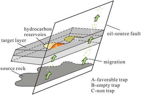
FIGURE 1. Schematic diagram of hydrocarbon accumulation patterns controlled by an oil-source fault.
Therefore, only when fault-transported hydrocarbon positions are coupled with traps can hydrocarbons accumulate to form reservoirs. If either the hydrocarbons or the trap is absent; or even if both of them are present, but they are not coupled in space, hydrocarbon reservoirs cannot form. The coupling sites of hydrocarbon transportation positions and favorable traps are favorable positions for hydrocarbon accumulation controlled by oil-source faults.
Prediction Method
According to the above patterns, modified from the method in the literature of Fu and Yu (2021), a new method to predict favorable positions for hydrocarbon accumulation controlled by oil-source faults is proposed in this study. First, hydrocarbon transportation positions of oil-source faults and favorable traps near oil-source faults are identified. Then, by overlapping the identified hydrocarbon transportation positions and the traps, favorable positions for hydrocarbon accumulation are identified along with the areas of overlap. Therefore, the key contents of this method are the identification of hydrocarbon transportation positions and favorable traps.
Identification of Hydrocarbon Transportation Positions
First, the distribution of oil-source faults is determined according to the method in the literature (Fu and Wang, 2018), i.e., a fault that connects the source rock and target reservoir and stays active during the hydrocarbon accumulation period is regarded as an oil-source fault. Second, based on seismic data, the paleo fault throws of oil-source faults in the target layer during the hydrocarbon accumulation period are identified by using the maximum fault throw subtraction method (David and Bruce, 2009); then, the paleo fault throw is divided by fault activity time to obtain the paleo activity rate of different parts of the oil-source fault during the hydrocarbon accumulation period. Third, the minimum paleo activity rate (Vmin) at discovered oil and gas wells in the study area is determined; this minimum value is the threshold required for oil-source faults to transport hydrocarbons, as shown in Figure 2A. Only when the fault paleo activity rate is greater than the Vmin are the associated fractures in the fault zone developed; thereby, oil and gas can be transported along oil-source faults and be found in drilling wells. Otherwise, no oil and gas will be found. Lastly, areas where the paleo activity rate of oil-source faults is greater than the Vmin are identified to be favorable hydrocarbon transportation positions.
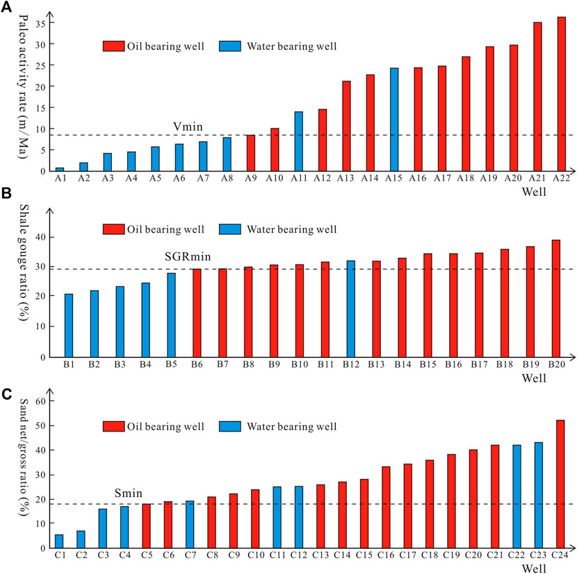
FIGURE 2. Schematic diagram of determining the thresholds of hydrocarbon transportation and accumulation (modified from Fu and Yu, 2021; Zhang and Fu, 2022). (A) Determination of threshold required for oil-source faults to transport hydrocarbons. (B) Determination of threshold required for faults to laterally seal hydrocarbons. (C) Determination of threshold required for sand bodies to store hydrocarbons. Vmin = threshold of paleo activity rate; SGRmin = threshold of shale gouge ratio; Smin = threshold of sand net/gross ratio.
Identification of Favorable Traps
Favorable traps near oil-source faults can be identified based on the identification of the position of fault traps, the lateral sealing position of faults, and the position of sand bodies that can store oil and gas. The area where the above three positions overlap is a favorable trap that can entrap hydrocarbons (Figure 3).
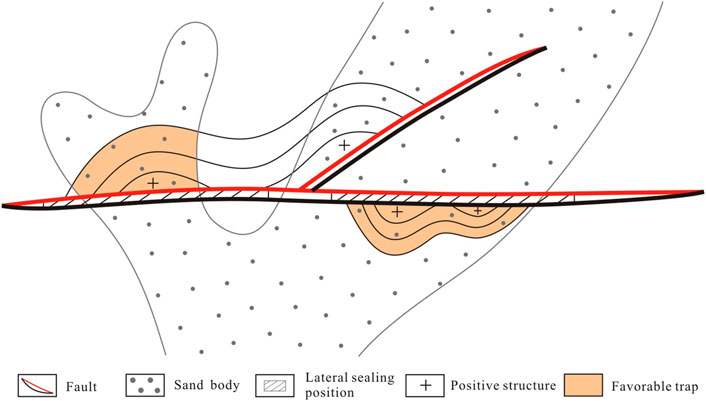
FIGURE 3. Schematic diagram of determining the favorable traps near oil-source faults.
The types of fault traps mainly include faulted anticlines, fault-block traps, and fault-screened traps. In terms of identifying the position of fault traps from the aspect of morphology, faulted anticlines, and fault-block traps can be directly identified from structural maps, while fault-screened traps can only be distinguished according to the configuration between the strata and the faults in seismic profiles.
The lateral sealing position of faults can be quantitatively determined by using the shale gouge ratio (SGR) method (Yielding et al., 1997; Song et al., 2020). First, the SGR of faults in the target layer is calculated using Eq. 1 with information from drilling and seismic data.
where SGR is the shale gouge ratio of fault rocks (%), Hi is the thickness of the i-th layer that is disrupted by the fault (m), Ri is the shale content of the i-th layer that is disrupted by the fault (%), L is the fault throw of the fault (m), and
Then, the SGR at the tested wells in the study area is counted, and the minimum shale gouge ratio (SGRmin) at the oil and gas wells is taken as the threshold required for faults to laterally seal hydrocarbons, as shown in Figure 2B. This is because only when the shale gouge ratio of a fault is greater than the SGRmincan oil and gas be trapped by the fault and accumulate in the trap; thus, oil and gas can be found by drilling wells here. Otherwise, no oil and gas will be found. Lastly, areas where the shale gouge ratio is greater than the SGRmin are recognized to be the lateral sealing positions of faults.
To determine the position of sand bodies that can store oil and gas, drilling data should be used to calculate the sand net/gross ratio of the target layer near the oil-source faults. Then, the sand net/gross ratio of test wells in the target layer is counted, and the minimum sand net/gross ratio (Smin) at the oil and gas wells is regarded as the threshold required for sand bodies to store hydrocarbons, as shown in Figure 2C. This is because only when the sand net/gross ratio of a layer is greater than the Smin can sand bodies have connectivity and store oil and gas; otherwise, oil and gas can hardly migrate from oil-source faults to sand bodies. Lastly, areas where the sand net/gross ratio of the target layer is greater than the Smin are circled and considered to be the locations of sand bodies that can store oil and gas.
Example Application
In this study, the Dazhangtuo fault (an oil-source fault) in the Qikou Sag, Bohai Bay Basin, East China is taken as an example to apply the above method to predict favorable hydrocarbon accumulation positions. Moreover, the prediction results and the discovered oil and gas are compared to verify the feasibility of this method.
Geological Setting
The Bohai Bay Basin is the largest petroliferous basin in eastern China, it has an area of approximately 2 × 10⁵ km2 (Zhou et al., 2012). The Bohai Bay Basin is divided into seven depressions by four uplifts, among which the Huanghua Depression is located in the center of the Bohai Bay Basin (Figure 4B; Chen et al., 2014; Song et al., 2021). The Huanghua Depression is rich in oil and gas resources in the Cenozoic strata and comprises two secondary depressions, i.e., the Qikou Sag and the Cangdong Sag (Zhou et al., 2019). The Qikou Sag, the largest sag in the Huanghua Depression, is an intracontinental rift lake basin (Huang et al., 2012). The sag has undergone tectonic evolution from the Paleogene rift stage to the Neogene depression stage. During the rifting stage, the structural framework of the main sag, five sub-sags, and four bulges were formed (Figure 4C; Huang et al., 2012; Zhou et al., 2019).
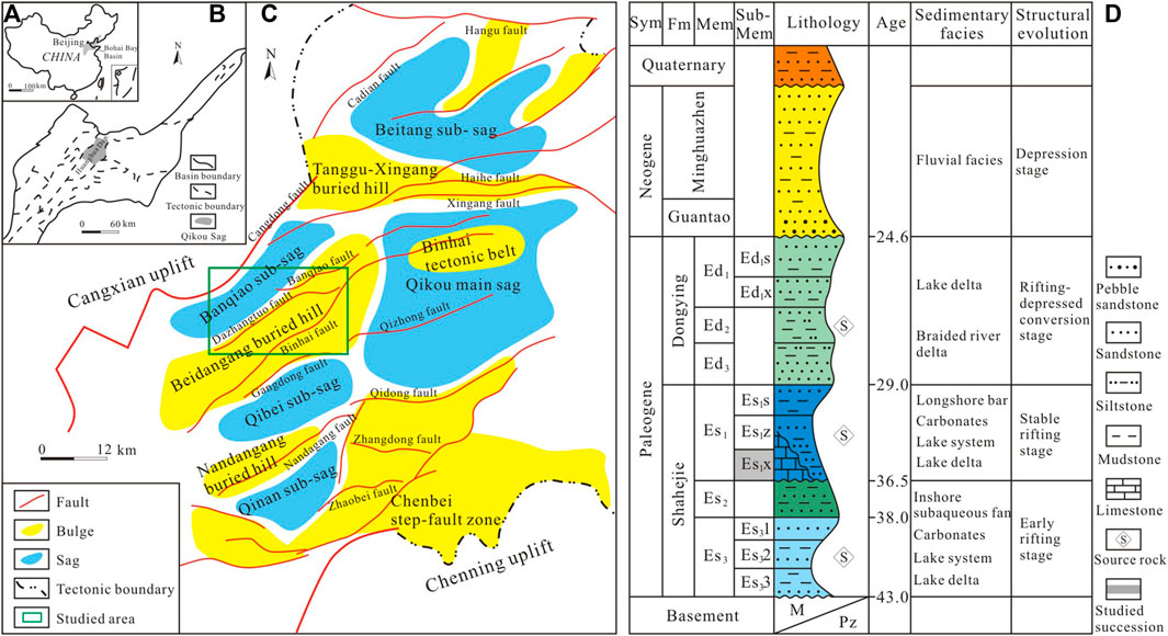
FIGURE 4. Regional geological map and stratigraphic comprehensive histogram of the Qikou Sag, Bohai Bay Basin. (A) Location of the Bohai Bay Basin. (B) Location of the Huanghua Depression. (C) Geological map of the Qikou Sag. (D) Stratigraphic histogram of the Qikou Sag. Sym = system, Fm = formation, Mem = member, Sub-Mem = sub-member (modified from Huang et al., 2012; Song et al., 2022).
The Palaeogene and Neogene stratigraphy in the Qikou Sag include, from bottom to top, the Shahejie Formation (Es), the Dongying Formation (Ed), the Guantao Formation (Ng), and the Minghuazhen Formation (Nm) (Figure 4D; Huang et al., 2012; Song et al., 2022). The Es, which is subdivided into the third (Es3), second (Es2), and first (Es1) members, is one of the main targets for hydrocarbon exploration in the sag. The Es3 and Es2 mostly consist of dark-gray mudstone and sandstone, representing a delta-lake-subaqueous fan sedimentary system. During the period of deposition of the Es1, the sag was dominated by a lake-delta-carbonate platform sedimentary system where mudstone, sandstone, and limestone were deposited (Song et al., 2022). Es3 and Es1 are regarded as the principal source rocks for crude oil (Figure 4D; Wang et al., 2014; Zhu et al., 2022). Es3, Es2, and Es1 are all favorable reservoirs, and many industrial oil and gas reservoirs have been discovered in the lower sub-member (Es1x) of the first member of the Shahejie Formation (Wang et al., 2014; Shi et al., 2019). Hydrocarbon accumulation in the Qikou Sag mainly occurred from the end of the deposition of the Guantao Formation to the present (Jin et al., 2019). In this study, the Es1x is the study interval, and the Ban 2 oil group of the Es1x is further considered.
Due to multistage tectonic movements, a large number of master faults are developed in the sag (Zhou et al., 2012). Most of these faults are connected with the source rock of the Es3 or the Es1 to form oil-source faults; these faults include the Banqiao fault, the Dazhangtuo fault, the Nandagang fault, and the Gangdong fault. (Figure 4C). It has been demonstrated that the vertical migration of hydrocarbons along faults is the main hydrocarbon migration model of oil and gas in the Cenozoic strata (Zhou et al., 2019; Zhu et al., 2022). The discovered oil and gas are obviously controlled by oil-source faults. For example, under the control of the Dazhangtuo fault, oil and gas in the Es1x are differentially enriched near the fault. Therefore, the Dazhangtuo fault can be used as a good example for predicting the favorable positions of oil-source faults controlling hydrocarbon accumulation.
The Dazhangtuo fault lies in the north of the Qikou Sag and is adjacent to the Banqiao sub-sag (Figure 4C). It has an extended length of 21.3 km and a dip angle of 55°–62°. The Dazhangtuo fault is a long-term developed normal fault and was active during the hydrocarbon accumulation period (from the end of deposition of the Guantao Formation to the present). Moreover, as shown in Figure 5A, the Dazhangtuo fault connects the source rock of Es3 and the reservoir of Es1x. Therefore, it is an oil-source fault for the Es1x. According to exploration results, a large amount of oil and gas have been discovered in the Shahejie Formation near the Dazhangtuo fault, and the Ban 2 oil group of the Es1x is a principal producing layer. As can be seen from Figure 5B, the oil and gas discovered in the Ban 2 oil group near the Dazhangtuo fault are abundantly distributed in the northeast with a small amount in the southwest; this result is predominantly controlled by the Dazhangtuo fault. Therefore, whether it is possible to accurately predict the locations of favorable hydrocarbon accumulation spots controlled by the Dazhangtuo fault in the Ban 2 oil group is very important for guiding hydrocarbon exploration in this area.

FIGURE 5. Characteristics of the Dazhangtuo fault. (A) Seismic section of the Dazhangtuo fault, location of the section shown in Figure 5B. (B) Oil and gas distribution of the Ban 2 oil group and fault traps around the Dazhangtuo fault in the Qikou Sag. Nm = Minghuazhen Formation; Ng = Guantao Formation; Ed = Dongying Formation; Es1s, Es1z, and Es1x = the upper, middle, and lower sub-member of the first member of the Shahejie Formation; Es2, Es3 = the second, third member of the Shahejie Formation.
Hydrocarbon Transportation Positions Along the Dazhangtuo Fault
First, fault throws from different survey lines of the Dazhangtuo fault in the Ban 2 oil group were calculated using 3D seismic data. Second, the maximum fault throw subtraction method was used to restore the fault throws to the paleo fault throws during the hydrocarbon accumulation period. Then, the paleo fault throw is divided by the fault activity time to obtain the paleo activity rate (Figure 6). It can be seen from the results that the paleo activity rates of the Dazhangtuo fault are mostly greater than 5 m/Ma, and the areas with high paleo activity rates are distributed in the center of the fault, showing a decreasing trend from the middle to the ends of the northeast and southwest (Figure 6). The minimum paleo activity rate required for oil-source faults to transport hydrocarbons is about 4 m/Ma in the Qikou Sag (Figure 7A). Therefore, it is determined that except for the northeast and southwest of the Dazhangtuo fault, the rest of the fault are all locations where hydrocarbons were transported (Figure 6).
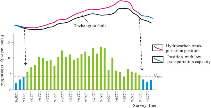
FIGURE 6. Determination of hydrocarbon transportation position along the Dazhangtuo fault.
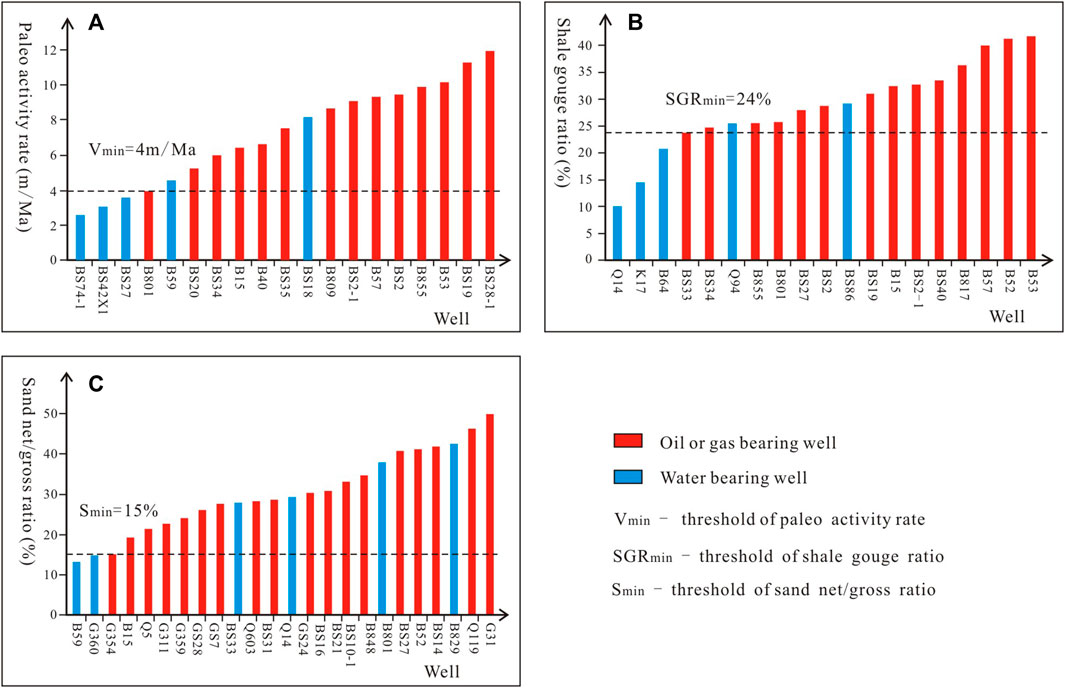
FIGURE 7. Parameter thresholds of hydrocarbon transportation and accumulation in the Ban 2 oil group in the Qikou Sag. (A) Threshold of hydrocarbon transportation of oil-source faults. (B) Threshold of laterally sealing positions of faults. (C) Threshold of sand bodies storing oil and gas.
Favorable Traps Along the Dazhangtuo Fault
According to the above method, favorable traps along the Dazhangtuo fault are identified from three aspects: the position of fault traps, the lateral sealing position of the fault, and the distribution of sand bodies that can store oil and gas.
In terms of the position of the fault traps, it can be seen from Figure 5B that there are fault anticlines in the northeast and southwest of the hanging wall, and fault-block traps in the northeast of the footwall of the Dazhangtuo fault in the Ban 2 oil group. Although there are no structural traps developed in the middle of the fault on the structural map, the analysis of the configuration between the Dazhangtuo fault and the Ban 2 oil group through seismic profiles shows that fault-screened traps could have developed in the middle part (Figure 5A). Therefore, fault traps from the aspect of morphology are developed near the entire Dazhangtuo fault, especially in the hanging wall of the fault.
In terms of the lateral sealing position, the fault throw of the Dazhangtuo fault in the Ban 2 oil group and the thickness and shale content of the layer disrupted by the fault were calculated using drilling and seismic data. Then, the SGR was calculated using Eq. 1 (Figure 8A). According to the relationship between the SGR and the oil and gas distribution in the Qikou Sag, the minimum shale gouge ratio required for faults to laterally seal oil and gas is about 24% (Figure 7B). Therefore, the lateral sealing positions of the Dazhangtuo fault are mainly distributed in its central and northeastern parts (Figure 8A).
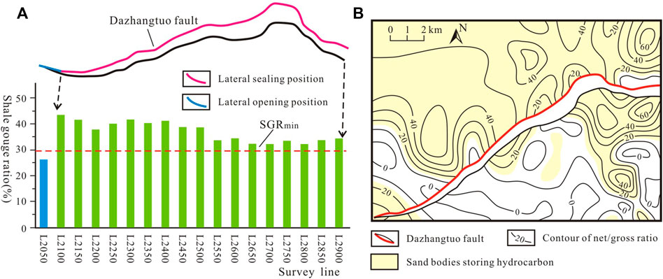
FIGURE 8. Determination of hydrocarbon accumulation positions along the Dazhangtuo fault. (A) Lateral sealing position of the Dazhangtuo fault in the Ban 2 oil group. (B) the area of sand bodies storing hydrocarbons in the Ban 2 oil group.
In terms of the distribution of sand bodies that can store oil and gas, the sand net/gross ratio of the Ban 2 oil group near the Dazhangtuo fault was calculated using drilling data (e8B). According to the relationship between the sand net/gross ratio of the Ban 2 oil group and the oil and gas distribution in the Qikou Sag, the minimum sand net/gross ratio required for sand bodies to store oil and gas is about 15% (Figure 7C). Based on this, it is determined that sand bodies with the ability to store oil and gas in the Ban 2 oil group near the Dazhangtuo fault are mainly located in the central and northeastern parts of the hanging wall and the northeastern part of the footwall (Figure 8B).
By overlapping the position of fault traps, the fault lateral sealing position, and the distribution of sand bodies with the ability to store oil and gas, favorable traps near the Dazhangtuo fault in the Ban 2 oil group were identified, these traps are mainly distributed in the central and northeastern portions of the fault (Figure 9).
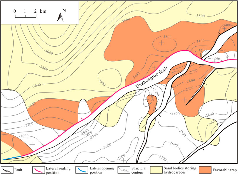
FIGURE 9. Identification of favorable traps along the Dazhangtuo fault in the Ban 2 oil group in the Qikou Sag.
Favorable Hydrocarbon Accumulation Positions Along the Dazhangtuo Fault
By superimposing the identified hydrocarbon transportation positions and the favorable traps along the Dazhangtuo fault, it was found that the favorable positions (coupling sites) for hydrocarbon accumulation in the Ban 2 oil group are mainly distributed in the northeast and center of the fault (Figure 10). Meanwhile, the discovered oil and gas near the Dazhangtuo fault are just located at or near the favorable hydrocarbon accumulation positions identified by the newly proposed method (Figure 10). However, almost all of the water-bearing wells are located in unfavorable positions for hydrocarbon accumulation. Due to a lack of oil-gas supply or a lack of favorable traps, no oil and gas reservoirs are present in unfavorable positions for hydrocarbon accumulation. These include Well B59 which is not near hydrocarbon transportation position and Wells B801 and B84 which are not near favorable traps (Figure 10). Therefore, the sites where hydrocarbon transportation positions overlap with favorable traps are the main locations for hydrocarbon accumulation. This is because only in the overlapping positions could hydrocarbons generated in the source rock of the Es3 migrate to the overlying Ban 2 oil group through conduits of the Dazhangtuo fault and then subsequently laterally migrate to favorable traps to form oil and gas reservoirs.
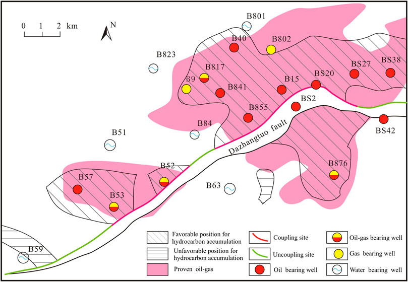
FIGURE 10. Prediction of favorable positions for hydrocarbon accumulation along the Dazhangtuo fault in the Ban 2 oil group.
In addition, due to the inaccurate identification of the fault traps, the area of proven oil and gas is larger than that of the predicted favorable positions for hydrocarbon accumulation. At present, the accurate identification of traps is still a key problem in hydrocarbon exploration, and many factors may lead to the inaccurate identification of traps, such as the accuracy of the structural map, the prediction accuracy of sand bodies, and the recognition accuracy of fault and sand configuration. Therefore, on the basis of adopting this method, the identification of favorable traps should be strengthened, which is also the aspect that the authors want to improve later.
Conclusion
1) The sites where hydrocarbon transportation positions overlap with favorable traps are the favorable locations for hydrocarbon accumulation controlled by oil-source faults.
2) A method of coupling hydrocarbon transportation positions and favorable traps to predict favorable hydrocarbon accumulation positions controlled by oil-source faults is established. In the method, the paleo activity rate is used to determine hydrocarbon transportation positions; the morphology of fault traps, fault lateral sealing position, and the distribution of sand bodies storing oil and gas are superimposed to obtain the locations of favorable traps.
3) The favorable hydrocarbon accumulation positions along the Dazhangtuo fault in the Ban 2 oil group in the Qikou Sag are the northeastern and central parts, which is consistent with the discovered oil and gas distribution.
4) The successful application of the proposed method to the Dazhangtuo fault shows that it is suitable for predicting favorable hydrocarbon accumulation positions controlled by oil-source faults in petroliferous basins.
Data Availability Statement
The raw data supporting the conclusions of this article will be made available by the authors, without undue reservation.
Author Contributions
FJ and GF presented the idea and design of the research. FJ wrote the manuscript and led the data analysis and interpreted the results with HW and XH. GH, XD, and WZ contributed to review and writing of the revised manuscript. All authors contributed to manuscript revision and approved it for publication.
Funding
This research was supported by the National Natural Science Foundation of China (Grant No. 41872157; 42002140), the Key Laboratory for the Formation Mechanism and Resource Evaluation of Oil and Gas Reservoir in Heilongjiang province (Grant NO. KL20190103) and the Young Science Foundation of Northeast Petroleum University (Grant NO. 2018QNL-27).
Conflict of Interest
GH, XD, and WZ were employed by the company PetroChina Dagang Oilfield Company.
The remaining authors declare that the research was conducted in the absence of any commercial or financial relationships that could be construed as a potential conflict of interest.
Publisher’s Note
All claims expressed in this article are solely those of the authors and do not necessarily represent those of their affiliated organizations, or those of the publisher, the editors, and the reviewers. Any product that may be evaluated in this article, or claim that may be made by its manufacturer, is not guaranteed or endorsed by the publisher.
Acknowledgments
The authors gratefully acknowledge the Science and Technology Innovation Team in Heilongjiang Province and PetroChina Dagang Oilfield Company for their help in this study.
References
Allan, U. S. (1989). Model for Hydrocarbon Migration and Entrapment within Faulted Structures. Am. Assoc. Pet. Geol. Bull. 73, 803–811. doi:10.1306/44B4A271-170A-11D7-8645000102C1865D
Aydin, A. (2000). Fractures, Faults, and Hydrocarbon Entrapment, Migration and Flow. Mar. Petroleum Geol. 17 (7), 797–814. doi:10.1016/S0264-8172(00)00020-9
Bense, V. F., Van den Berg, E. H., and Van Balen, R. T. (2003). Deformation Mechanisms and Hydraulic Properties of Fault Zones in Unconsolidated Sediments; the Roer Valley Rift System, The Netherlands. Hydrogeology J. 11 (3), 319–332. doi:10.1007/s10040-003-0262-8Introduction
Chen, S., Wang, H., Wu, Y., Huang, C., Wang, J., Xiang, X., et al. (2014). Stratigraphic Architecture and Vertical Evolution of Various Types of Structural Slope Breaks in Paleogene Qikou Sag, Bohai Bay Basin, Northeastern China. J. Petroleum Sci. Eng. 122, 567–584. doi:10.1016/j.petrol.2014.07.003
Chen, W., Wu, Z. P., Hou, F., Li, W., and Hou, X. B. (2010). Study on Hydrocarbon Migration along Fault Strike. J. China Univ. Petroleum Ed. Nat. Sci. 34 (6), 25–30. doi:10.3969/j.issn.1673-5005.2010.06.005
Cong, F., Zhang, H., Hao, F., and Xu, S. (2020). Direct Control of Normal Fault in Hydrocarbon Migration and Accumulation in Northwestern Bozhong Subbasin, Bohai Bay Basin, China. Mar. Petroleum Geol. 120, 104555. doi:10.1016/j.marpetgeo.2020.104555
David, M. D., and Bruce, D. T. (2009). Four-dimensional Analysis of the Sembo Relay System, Offshore Angola: Implications for Fault Growth in Salt-Detached Settings. Am. Assoc. Pet. Geol. Bull. 93 (6), 763–794. doi:10.1306/02230908094
Fossen, H., and Rotevatn, A. (2016). Fault Linkage and Relay Structures in Extensional Settings-A Review. Earth-Science Rev. 154, 14–28. doi:10.1016/j.earscirev.2015.11.014
Fu, G., Liang, M. G., and Li, J. R. (2021). Improved Prediction Method of Favorable Positions for Oil and Gas Transport of Active Oil-Source Faults. J. China Univ. Petroleum Ed. Nat. Sci. 45 (6), 42–50. doi:10.3969/j.issn.1673-5005.2021.06.005
Fu, G., Liang, M. G., and Li, Q. Q. (2019). Effectiveness of Transporting Oil and Gas of Source-Fault-Sandstone Space Matching. J. China Univ. Min. Technol. 48 (3), 584–591. doi:10.13247/j.cnki.jcumt.000956
Fu, G., and Wang, H. R. (2018). Determination Method and its Application of Favorable Positions for Hydrocarbon Transport in Oil-Source Fault during Different Periods. Acta Pet. Sin. 39 (2), 180–188. doi:10.7623/syxb201802006
Fu, G., and Wang, H. R. (2019). Prediction Method of Favorable Position in Oil-Gas Accumulation Around Oil-Source Fault and its Application. Geotect. Metallogenia 43 (1), 69–76. doi:10.16539/j.ddgzyckx.2019.01.006
Fu, G., and Yu, T. (2021). Proposed Method for Predicting Favorable Locations for Oil and Gas Migration and Accumulation in Source-Faulted-Sand Zones Near Faults and its Application. Acta Sedimentol. Sin. 1, 13. doi:10.14027/j.issn.1000-0550.2021.071
Goldsworthy, M., and Jackson, J. (2001). Migration of Activity within Normal Fault Systems: Examples from the Quaternary of Mainland Greece. J. Struct. Geol. 23 (2-3), 489–506. doi:10.1016/S0191-8141(00)00121-8
Gong, L., Fu, X., Wang, Z., Gao, S., Jabbari, H., Yue, W., et al. (2019). A New Approach for Characterization and Prediction of Natural Fracture Occurrence in Tight Oil Sandstones with Intense Anisotropy. Am. Assoc. Pet. Geol. Bull. 103 (6), 1383–1400. doi:10.1306/12131818054
Gong, L., Gao, S., Liu, B., Yang, J., Fu, X., Xiao, F., et al. (2021a). Quantitative Prediction of Natural Fractures in Shale Oil Reservoirs. Geofluids 2021, 1–15. doi:10.1155/2021/5571855
Gong, L., Wang, J., Gao, S., Fu, X., Liu, B., Miao, F., et al. (2021b). Characterization, Controlling Factors and Evolution of Fracture Effectiveness in Shale Oil Reservoirs. J. Petroleum Sci. Eng. 203, 108655. doi:10.1016/j.petrol.2021.108655
Hooper, E. C. D. (1991). Fluid Migration along Growth Faults in Compacting Sediments. J. Petroleum Geol. 14 (2), 161–180. doi:10.1111/j.1747-5457.1991.tb00360.x
Hu, X. L., and Lyu, Y. F. (2019). Improvement of Lateral Sealing Evaluation of Faults Based on SGR Threshold. J. China Univ. Min. Technol. 48 (6), 1330–1342. doi:10.13247/j.cnki.jcumt.001045
Huang, C., Wang, H., Wu, Y., Wang, J., Chen, S., Ren, P., et al. (2012). Genetic Types and Sequence Stratigraphy Models of Palaeogene Slope Break Belts in Qikou Sag, Huanghua Depression, Bohai Bay Basin, Eastern China. Sedimentary Geol. 261-262, 65–75. doi:10.1016/j.sedgeo.2012.03.005
Jackson, C. A. L., Gawthorpe, R. L., and Sharp, I. R. (2006). Style and Sequence of Deformation during Extensional Fault-Propagation Folding: Examples from the Hammam Faraun and El-Qaa Fault Blocks, Suez Rift, Egypt. J. Struct. Geol. 28 (3), 519–535. doi:10.1016/j.jsg.2005.11.009
Jiang, G. P., Fu, G., and Sun, T. W. (2017). Determination of Hydrocarbon Transporting Capacity and Hydrocarbon Enrichment Differences of Oil Source Faults Using Seismic Data. Prog. Geophys. 32 (1), 160–166. doi:10.6038/pg20170122
Jiang, Y., Zhao, K., Liu, J., and Lü, X. (2018). A Quantitative Method for Evaluating the Transporting Capacity of Oil-Source Faults in Shallow Formation of Oil-Rich Sags. Acta Geol. Sin. - Engl. Ed. 92 (4), 1678–1679. doi:10.1111/1755-6724.13663
Jin, F., Wang, X., Li, H., Wu, X., Fu, L., Lou, D., et al. (2019). Formation of the Primary Petroleum Reservoir in Wumaying Inner Buried-Hill of Huanghua Depression, Bohai Bay Basin, China. Petroleum Explor. Dev. 46 (3), 543–552. doi:10.1016/S1876-3804(19)60034-0
Kumar, P. C., Omosanya, K. d. O., Alves, T. M., and Sain, K. (2019). A Neural Network Approach for Elucidating Fluid Leakage along Hard-Linked Normal Faults. Mar. Petroleum Geol. 110, 518–538. doi:10.1016/j.marpetgeo.2019.07.042
Lampe, C., Song, G., Cong, L., and Mu, X. (2012). Fault Control on Hydrocarbon Migration and Accumulation in the Tertiary Dongying Depression, Bohai Basin, China. Am. Assoc. Pet. Geol. Bull. 96 (6), 983–1000. doi:10.1306/11031109023
Liang, M., Fu, G., Han, X., and Li, Q. (2022). Mapping of Oil-Source Faults in Reservoir-Cap Rock Combinations without a Source Rock. Energy Geosci. 3 (2), 103–110. doi:10.1016/j.engeos.2021.11.007
Liu, B., Song, Y., Zhu, K., Su, P., Ye, X., and Zhao, W. (2020). Mineralogy and Element Geochemistry of Salinized Lacustrine Organic-Rich Shale in the Middle Permian Santanghu Basin: Implications for Paleoenvironment, Provenance, Tectonic Setting and Shale Oil Potential. Mar. Petroleum Geol. 120, 104569. doi:10.1016/j.marpetgeo.2020.104569
Liu, J. Q., Zhang, T., Sun, T. W., Sun, Y. H., and Wang, Y. T. (2017). Controlling Effect of Conducting Capacity of Oil Source Faults on Oil and Gas Distribution. Special Oil Gas Reservoirs 24 (5), 27–31. doi:10.3969/j.issn.1006-6535.2017.05.005
Losh, S. (1998). Oil Migration in a Major Growth Fault: Structural Analysis of the Pathfinder Core, South Eugene Island Block 330, Offshore Louisiana. Am. Assoc. Pet. Geol. Bull. 82 (9), 1694–1710. doi:10.1306/1d9bcb79-172d-11d7-8645000102c1865d
Luo, Q. (2010). Concept, Principle, Model and Significance of the Fault Controlling Hydrocarbon Theory. Petroleum Explor. Dev. 37 (3), 316–324. doi:10.1016/S1876-3804(10)60035-3
Luo, X. R., Lei, Y. H., Zhang, L. K., Chen, R. Y., Chen, Z. K., Xu, J. H., et al. (2012). Characterization of Carrier Formation for Hydrocarbon Migration: Concepts and Approaches. Acta Pet. Sin. 33 (3), 428–436. doi:10.7623/syxb201203012
Luo, X., Zhang, L., Lei, Y., and Yang, W. (2020). Petroleum Migration and Accumulation: Modeling and Applications. Am. Assoc. Pet. Geol. Bull. 104 (11), 2247–2265. doi:10.1306/0422201618817104
Lyu, Y., Hu, X., Jin, F., Xiao, D., Luo, J., Pu, X., et al. (2021). Quantitative Evaluation of Lateral Sealing of Extensional Fault by an Integral Mathematical-Geological Model. Petroleum Explor. Dev. 48 (3), 569–580. doi:10.1016/S1876-3804(21)60046-0
Lyu, Y., Wang, W., Hu, X., Fu, G., Shi, J., Wang, C., et al. (2016). Quantitative Evaluation Method of Fault Lateral Sealing. Petroleum Explor. Dev. 43 (2), 340–347. doi:10.1016/S1876-3804(16)30040-4
Schlische, R. W. (1995). Geometry and Origin of Fault-Related Folds in Extensional Settings. Am. Assoc. Pet. Geol. Bull. 79 (11), 1661–1678. doi:10.1306/7834DE4A-1721-11D7-8645000102C1865D
Shi, J. J., Li, L. L., Du, L., and Song, Y. G. (2019). Dynamic Damage of Fault to Caprock and its Influence on Hydrocarbon Transport: a Case Study of Gangdong Fault in Qikou Sag, Bohai Bay Basin. Acta Pet. Sin. 40 (8), 956–964. doi:10.7623/syxb201908006
Song, X., Meng, L., Fu, X., Wang, H., Sun, Y., and Jiang, W. (2020). Sealing Capacity Evolution of Trap-Bounding Faults in Sand-Clay Sequences: Insights from Present and Paleo-Oil Entrapment in Fault-Bounded Traps in the Qinan Area, Bohai Bay Basin, China. Mar. Petroleum Geol. 122, 104680. doi:10.1016/j.marpetgeo.2020.104680
Song, Y., Cao, Q., Li, S., Hu, S., Zhu, K., Ye, X., et al. (2021). Salinized Lacustrine Organic-Rich Shale Influenced by Marine Incursions: Algal-Microbial Community, Paleoenvironment and Shale Oil Potential in the Paleogene Biyang Depression, East China. Palaeogeogr. Palaeoclimatol. Palaeoecol. 580, 110621. doi:10.1016/j.palaeo.2021.110621
Song, Y., Li, S., and Hu, S. (2019). Warm-humid Paleoclimate Control of Salinized Lacustrine Organic-Rich Shale Deposition in the Oligocene Hetaoyuan Formation of the Biyang Depression, East China. Int. J. Coal Geol. 202, 69–84. doi:10.1016/j.coal.2018.11.016
Song, Y., Ye, X., Shi, Q., Huang, C., Cao, Q., Zhu, K., et al. (2022). A Comparative Study of Organic-Rich Shale from Turbidite and Lake Facies in the Paleogene Qikou Sag (Bohai Bay Basin, East China): Organic Matter Accumulation, Hydrocarbon Potential and Reservoir Characterization. Palaeogeogr. Palaeoclimatol. Palaeoecol. 594, 110939. doi:10.1016/j.palaeo.2022.110939
Wang, F., Chen, D., Du, W., Zeng, J., Wang, Q., Tian, Z., et al. (2021). Improved Method for Quantitative Evaluation of Fault Vertical Sealing: A Case Study from the Eastern Pinghu Slope Belt of the Xihu Depression, East China Sea Shelf Basin. Mar. Petroleum Geol. 132, 105224. doi:10.1016/j.marpetgeo.2021.105224
Wang, H. R., Fu, G., and Sun, T. W. (2016). Restoration of Paleo Transition Zone of Oil Source Fault and its Favorable Conditions for Hydrocarbon Transportation_ (10) Fault as an Example. Nat. Gas. Geosci. 27 (10), 1848–1854. doi:10.11764/j.issn.1672-1926.2016.10.1848
Wang, Z. S., Hua, S. J., Yu, X. M., and Jiang, W. Y. (2014). Grading Evaluation and High Quality Source Rock Distribution in Qikou Sag. Nat. Gas. Geosci. 25 (12), 1896–1902. doi:10.11764/j.issn.1672-1926.2014.12.1896
Yang, H., Xu, C., Niu, C., Qian, G., Li, Z., Gao, Y., et al. (2020). Quantitative Evaluation of Hydrocarbon Accumulation Pattern and the Controlling Factors in the Neogene of Huanghekou Sag Bohai Bay Basin. Oil & Gas Geol. 41 (2), 259–269. doi:10.11743/ogg20200203
Yielding, G., Freeman, B., and Needham, D. T. (1997). Quantitative Fault Seal Prediction. Am. Assoc. Pet. Geol. Bull. 81 (6), 897–917. doi:10.1306/522B498D-1727-11D7-8645000102C1865D
Zeng, J., and Jin, Z. (2003). Experimental Investigation of Episodic Oil Migration along Fault Systems. J. Geochem. Explor. 78-79, 493–498. doi:10.1016/S0375-6742(03)00087-6
Zeng, L., Gong, L., Guan, C., Zhang, B., Wang, Q., Zeng, Q., et al. (2022). Natural Fractures and Their Contribution to Tight Gas Conglomerate Reservoirs: A Case Study in the Northwestern Sichuan Basin, China. J. Petroleum Sci. Eng. 210, 110028. doi:10.1016/j.petrol.2021.110028
Zhang, L., Liao, Z., Long, K., Carpenter, B. M., Zou, H., and Hao, F. (2022). Fundamental Constraints of Lithologically-Controlled Fault Networks on Gas Migration and Accumulation for Fractured Carbonates in the Western Sichuan Basin, China. J. Petroleum Sci. Eng. 208, 109502. doi:10.1016/j.petrol.2021.109502
Zhang, L., Luo, X., Liao, Q., Yang, W., Vasseur, G., Yu, C., et al. (2010). Quantitative Evaluation of Synsedimentary Fault Opening and Sealing Properties Using Hydrocarbon Connection Probability Assessment. Am. Assoc. Pet. Geol. Bull. 94, 1379–1399. doi:10.1306/12140909115
Zhang, B., and Fu, G. (2022). Identification Method of Evolution Patterns of Favorable Oil and Gas Channels at Source Fault Configuration and its Application. Front. Earth Sci. 10, 856321. doi:10.3389/feart.2022.856321
Zhou, L., Fu, L., Lou, D., Lu, Y., Feng, J., Zhou, S., et al. (2012). Structural Anatomy and Dynamics of Evolution of the Qikou Sag, Bohai Bay Basin: Implications for the Destruction of North China Craton. J. Asian Earth Sci. 47, 94–106. doi:10.1016/j.jseaes.2011.06.004
Zhou, L., Han, G., Dong, Y., Shi, Q., Ma, J., Hu, J., et al. (2019). Fault-sand Combination Modes and Hydrocarbon Accumulation in Binhai Fault Nose of Qikou Sag, Bohai Bay Basin, East China. Petroleum Explor. Dev. 46 (5), 919–934. doi:10.1016/S1876-3804(19)60249-1
Zhu, C., Gang, W., Zhao, X., Chen, G., Pei, L., Wang, Y., et al. (2022). Reconstruction of Oil Charging History in the Multi-Source Petroleum System of the Beidagang Buried-Hill Structural Belt in the Qikou Sag, Bohai Bay Basin, China: Based on the Integrated Analysis of Oil-Source Rock Correlations, Fluid Inclusions and Geologic Data. J. Petroleum Sci. Eng. 208, 109197. doi:10.1016/j.petrol.2021.109197
Keywords: hydrocarbon migration, hydrocarbon accumulation mechanism, fault lateral sealing, fault trap, Bohai Bay Basin
Citation: Jiang F, Fu G, Han G, Dong X, Zhang W, Wang H and Hu X (2022) Prediction of Favorable Positions for Hydrocarbon Accumulation Controlled by Oil-Source Faults: A Case of Dazhangtuo Fault in the Qikou Sag, Bohai Bay Basin, East China. Front. Earth Sci. 10:908812. doi: 10.3389/feart.2022.908812
Received: 31 March 2022; Accepted: 05 May 2022;
Published: 17 June 2022.
Edited by:
Wei Ju, China University of Mining and Technology, ChinaReviewed by:
Pingchang Sun, Jilin University, ChinaYu Song, China University of Geosciences Wuhan, China
Copyright © 2022 Jiang, Fu, Han, Dong, Zhang, Wang and Hu. This is an open-access article distributed under the terms of the Creative Commons Attribution License (CC BY). The use, distribution or reproduction in other forums is permitted, provided the original author(s) and the copyright owner(s) are credited and that the original publication in this journal is cited, in accordance with accepted academic practice. No use, distribution or reproduction is permitted which does not comply with these terms.
*Correspondence: Fei Jiang, amlhbmdmZWlzY0AxMjYuY29t