- 1Center for Hydrogeology and Environmental Geology Survey, CGS, Baoding, China
- 2School of Automation Engineering, University of Electronic Science and Technology of China, Chengdu, China
- 3Technology Innovation Center for Geological Environment Monitoring, MNR, Baoding, China
The equal time interval sampling in the existing landslide monitoring system cannot detect the abnormal change of landslides in real time. This study proposes a novel landslide monitoring method based on the long range (LoRa) network and intelligent sensing Internet of Things (IoT) to address these drawbacks. The overall structure, hardware circuit, and software design of intelligent sensing monitoring technology are described comprehensively. The designed adaptive data collection strategy can effectively capture abnormal changes in the landslide monitoring parameters, which provides a better alternative monitoring scheme for the real-time data collection of disaster body status. Furthermore, it can ensure data accuracy for the research of intelligent large-scale landslide disaster monitoring and prediction. The field test demonstrates that the proposed system presents the technical characteristics of low power consumption, self-organizing network, stable and reliable communication, and long transmission distance, which is effective for mountain landslide monitoring in harsh environments.
1 Introduction
Landslide is one of the most common and extremely threatening geological disasters in the world (Yin et al., 2009; Zhang et al., 2021). Extreme climatic conditions and human engineering activities have resulted in an increasing frequency of landslides. Landslides are characterized by fast movement, abrupt nature and strong concealment, which pose a considerable threat to the safety of residents and their property. Real-time dynamic deformation monitoring and early warning information of landslides can effectively reduce the potential casualties (Shruti et al., 2018). This approach is crucial for the prevention and mitigation of major geological disasters. The wireless sensor network has gradually become the most important technology for landslide monitoring as it does not depend on fixed network facilities (Azzam et al., 2010; Kay et al., 2014; Martina et al., 2015; Kumar et al., 2019). It is inexpensive, self-networking and highly reliable. Various wireless sensor networks (WSN) have been designed to realize the dynamic monitoring of landslides, such as the landslide wireless sensor monitoring network based on inertial navigation (Giri et al., 2019), landslide prediction and forecast system based on geotechnical parameters using LabVIEW visualization software and NI wireless sensor network platform (AhmedMoyed et al., 2019), and low power vibration WSN for early monitoring of landslide (Somchai et al., 2016; Jeong et al., 2020). Giorgetti et al. (2016) proposed a robust WSN for landslide monitoring and risk management and designed a node topology based on the CC2530 wireless sensor. Intrieri et al. (2012) developed a WSN based on extensometers, thermometers, rain gauges, and video surveillance, which explained the monitoring and early warning system in detail with the help of a case study. Adeel et al. (2019) reported that wireless communication technologies such as the Internet of Things (IoT), WSN, and 5G wireless communication present significant potential for the monitoring and prediction of geological disasters. Cui et al. and Sanchez-Iborra et al. designed IoT monitoring systems in different scenarios (Cui et al., 2018; Ramon et al., 2018) The studies presented above have proposed a novel approach for landslide geological disaster monitoring and have achieved certain research results.
The existing landslide wireless monitoring systems face the limitations of slow networking speed, data transmission lag, limited transmission distance, and high-power consumption. They cannot realize the large-scale, long-distance, and ad-hoc network monitoring of landslides; the reliability and stability of the transmission monitoring data cannot be ensured (Sandra et al., 2020). Therefore, this study proposes a novel wireless sensor landslide monitoring system through the application of Long Range (LoRa) wireless communication network technology to monitor landslides in complex mountainous areas. The system consists of field monitoring collection nodes and gateway nodes, and primarily collects and sends monitoring data through various on-site monitoring and collection nodes (Haziel et al., 2018; Lorenzo et al., 2019; Sandra et al., 2020). The aggregated data is then packaged and uploaded to a remote cloud server via a 4G mobile network. A geological disaster monitoring and early warning management system based on the C # language is used as the host computer software for data collection to realize the real-time display, data analysis, and early warning information release of field monitoring data. The wireless landslide monitoring system presents the advantages of light deployment, low cost, and low power consumption, which can be applied for the monitoring and early warning of landslides in harsh outdoor environments and are therefore effective for the prevention and management of landslides.
2 Overall System Design
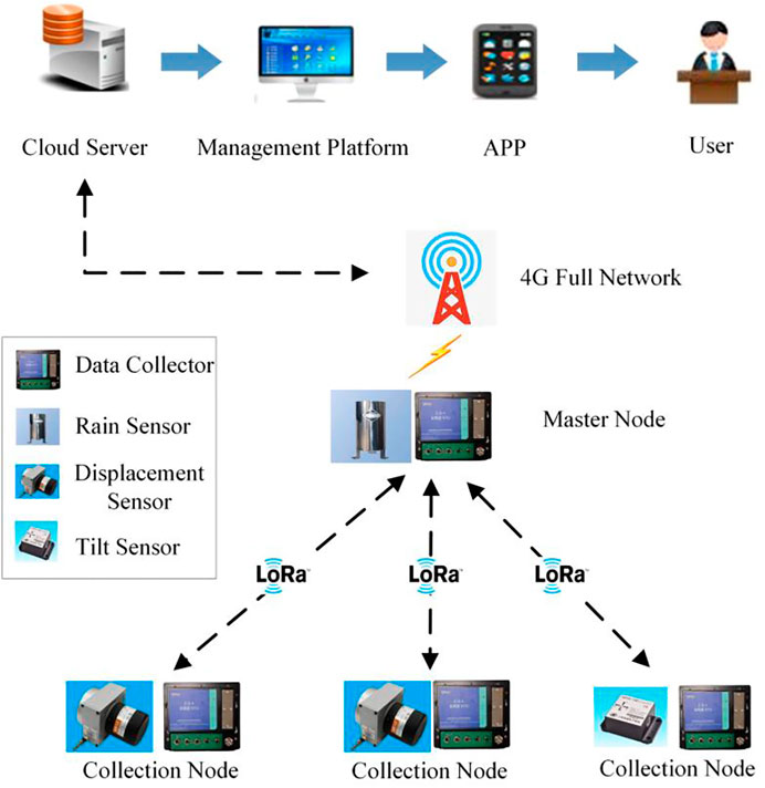
The landslide monitoring system is composed of two main parts: on-site monitoring, and collection and gateway nodes. The on-site monitoring and collection nodes are composed of an STM32L071RBT6 microprocessor, monitoring sensors (rainfall, displacement, tilt, acceleration), and the LoRa transmission module. The STM32 microprocessor processes the sensor data acquired by each collection node and transfers it to the gateway node through the LoRa module. The gateway node is composed of the STM32L071RBT6 microprocessor, LoRa module, and 4G full Netcom module. The STM32 microprocessor receives the sensor monitoring data, which is sent by the point reduction of each field monitoring terminal using the LoRa technology to transmit the monitoring data to the data monitoring center through the 4G full network modules (Du and Liu, 2019; Zhao et al., 2019; Guan-Peng et al., 2020; Wu and Sun, 2020). The host computer software in the server performs the storage, analysis, processing, display, and comprehensive early warning of the monitoring data (Wan et al., 2018; Zhang and Zhou, 2019). The landslide disaster mutation data can be simultaneously transmitted to managers and experts to make emergency decisions while reducing the power consumption of the equipment. Figure 1 presents the schematic diagram of the overall structure of the landslide monitoring system.
The system exhibits the characteristics of intelligent perception, intelligent collection, collaborative linkage, and intelligent early warning. It primarily comprises the following four layers:
1) The perception layer: It employs various monitoring sensors for the recognition and perception of environmental factors and deformation related to landslides.
2) The transmission layer: It employs the new generation of IoT (LoRa), Beidou, or maritime technology to transmit the disaster monitoring data obtained by the field monitoring sensor to the monitoring and early warning cloud platform, and creates the bidirectional transmission and command control of data information between the perception layer and the cloud server side.
3) The data layer: It performs intelligent perception database storage to monitor the data acquired on-site, and realizes the intelligent multi-source monitoring data fusion processing and visual representation of landslides.
4) The application layer: It comprehensively analyzes and determines the multi-source and multi-field monitoring data of the data layer, and provides various data support and decision-making application services for geological disaster managers and technicians.
3 Circuit Design of Landslide Monitoring System
The landslide monitoring system must be capable of multi-source real-time data collection, to collect the real-time sensor monitoring data such as rainfall, crack displacement, acceleration, and inclination of disaster bodies. This study proposes an intelligent sensing monitoring technology for abnormal variation of sensor data, which can monitor the changes in the parameters of each monitoring sensor, and perform the collection, perception, identification, convergence, and transmission of the monitoring sensors in real time (Zhang and Zhou, 2019; Zhao et al., 2019). A landslide disaster self-organizing network and an adaptive monitoring technology suitable for complex field environment are constructed through the design of an intelligent data collection algorithm based on a sensor abnormal data trigger collection and encryption collection strategy.
3.1 Microcontroller
The STM32L071 microcontroller includes the ARM Cortex-M0+ core, which is a low-cost and low-power RISC controller based on a 32 bit ARM architecture. It has a maximum operating frequency of 32 MHz and integrates various high-performance industrial interconnect standard interfaces, including 10 timers, AD Analog-to-digital conversion, DA digital-to-analog conversion, a wireless network interface, an external 2 Kbit IIC interface, and an SPI mode MicroSD storage interface. The microcontroller can realize three low-power working modes of sleep, shutdown, and standby, which is widely employed in the low power consumption field of IoT.
3.2 LoRa Module
LoRa is a low-power, long-distance wireless modulation and demodulation technology which uses the spread spectrum scheme. It is the first ultra-long-distance wireless transmission scheme to be popularized and applied by Semtech Corporation of America as a modulation technology of the linear frequency modulation spread spectrum. It presents a significantly higher receiving sensitivity and can achieve a longer communication distance than other modulation technologies. The main functional indicators of LoRa include: 1) Long transmission distance; the effective distance is 2–5 km in urban areas and 5–10 km in the field. 2) Flexible working frequency and supporting ISM frequency bands such as 433/868/915 MH. 3) Flexible access and large capacity; the gateway supports random access of nodes to the network and a single gateway supports the connection of thousands of LoRa nodes. 4) Strong real-time supporting full-duplex communication, and uplink and downlink concurrency. 5) Simple network topology; the stability of the star network is especially high. 6) Strong anti-interference ability; LoRa has excellent spread spectrum modulation and forward error correction capability when compared to the traditional FSK modulation technology. The LoRa wireless module in this system employs the SX1278 RF chip made by Semtech. The chip has a transmission power of 30 dBm (1 W) and supports LoRa spread spectrum and self-organizing network technology, which is suitable for wireless data communication transmission in complex environments. There are no additional relay devices and complex communication infrastructures in this system, considering that the effective monitoring range of the field landslide test site is less than 3 km.
3.3 Power Supply System Design
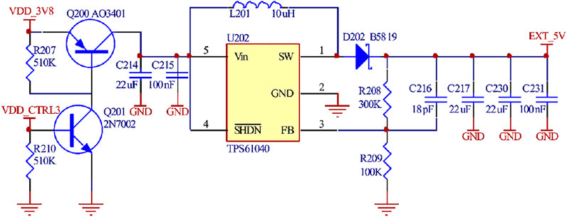
Because the landslide monitoring equipment needs to work stably in the wild environment for a long time. Therefore, the system adopts floating rechargeable lithium iron phosphate battery and solar panel power supply, and the lithium battery parameter is designed as 12V/10 Ah. The system must provide voltage supplies of 3.8 and 3.3 V. The 3.8 V voltage is provided by the TPS54260-Q1 conversion (Figure 2). The TPS54260-Q1 can achieve low-power voltage conversion within the range of 3.5–60 V, and can provide a maximum output current of 2.5 A. It is suitable for voltage conversion in the field of automatic control. The 3.3 V voltage is provided by SPX5205 conversion (Figure 3). The peripheral circuit of the chip is simple, and the output voltage is highly accurate. Additionally, TPS61040 converts 3.8 V to a standard voltage of 5 V for the displacement and inclination sensors, as shown in Figure 4.
3.4 Sensor Circuit Design
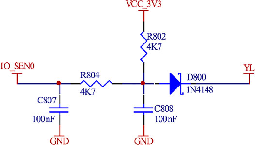
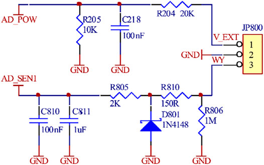
The circuit design of the rainfall monitoring sensor is very simple. It primarily uses the tipping bucket rainfall sensor to convert the output of the switching quantity by using the pulse voltage value. The microcontroller obtains the on-site rainfall monitoring data via counting. The displacement sensor circuit primarily uses the 12-bit ADC circuit inside the microprocessor to obtain the displacement data, which is converted into the corresponding voltage value output by changing the resistance value of the displacement sensor. Figures 5, 6 illustrate the rainfall and displacement sensors.
3.5 Collection Sub-node Design
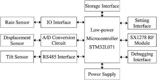
The collection sub-node is an optimized integration of sensors, data acquisition instruments, LoRa wireless modules, and power supply systems. It focuses on the collection of the sensor data for each monitoring point of the landslide, as shown in Figure 7. The main functions of the collecting sub-nodes include (1) collecting sensor data such as the rainfall, crack displacement, and soil pressure data; (2) establishing two-way communication control with LoRa master node and sending data to the master node. The rainfall sensor collects the data through the IO interface of the switch quantity, the crack displacement collects the data through the AD conversion circuit, and the tilt sensor collects the data using the RS485 interface.
3.6 Master Node Design
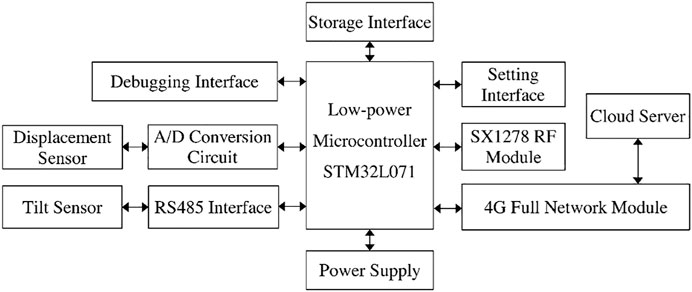
The main function of the node is to realize bidirectional protocol control with the cloud server and to collect the monitoring data of each sub-node, as shown in Figure 8. The master node collects the data of each sub-node and sends the monitoring data to the cloud server through 4G or Beidou short message. Additionally, the master node also performs the data acquisition function; the rainfall acquisition function is usually included in the master node.
4 Software Design of Landslide Monitoring System
The proposed system includes an effective multi-task scheduling mechanism, which can perform the simultaneous real-time data acquisition of multi-monitoring parameters of landslides and thus, effectively control the power consumption. Through The two-way control presented by the geological disaster monitoring and early warning information management platform enables the real-time activation of the on-site acquisition nodes, and the prompt and accurate upload of the on-site landslide monitoring data (Dong and Huang, 2017; Han et al., 2020).
4.1 Application Layer Communication Protocol Design
The system designs the application layer protocol for the master node and the sub-node, and synchronously realizes the encapsulation and transparent transmission of each packet. The data transmission between the master node and the sub-node is performed through the data frame, and the CRC16 algorithm is used to verify the corresponding data. In the sensor data acquisition process, the cloud server first sends the protocol instructions to each acquisition sub-node through the main node. The data is returned to the acquisition sub-node after the field sensor obtains the protocol response. Subsequently, the acquisition sub-nodes process their monitoring data, which are sent to the master node after packaging. Lastly, the main node sends all the monitoring data to the cloud server.
This study designs a flexible LoRa data transmission communication protocol, in which the data transmission mode adopts the data frame mode. A one-to-many mapping relationship can be immediately established between the gateway nodes and collection nodes after the LoRa wireless sensor network is created. Tables 1 and 2 present the frame structures used to upload data and send commands.
The system employs a star ad-hoc network for communication and transmission between the gateway (master) node and collection nodes. The LoRa module defines the corresponding upload data frame and the command frame for the collection node and the gateway node. The frame header of the upload data frame is 0 × 55, the address is the device address of the collection node, the type is the monitoring sensor type, and the length is the length of monitoring sensor data. There are two states: normal and threshold. The frame header of the issued command frame is 0 x FF, and the data content is the device address of the collection node being queried.
4.2 Ad-Hoc Network Design of Master Node and Sub-node
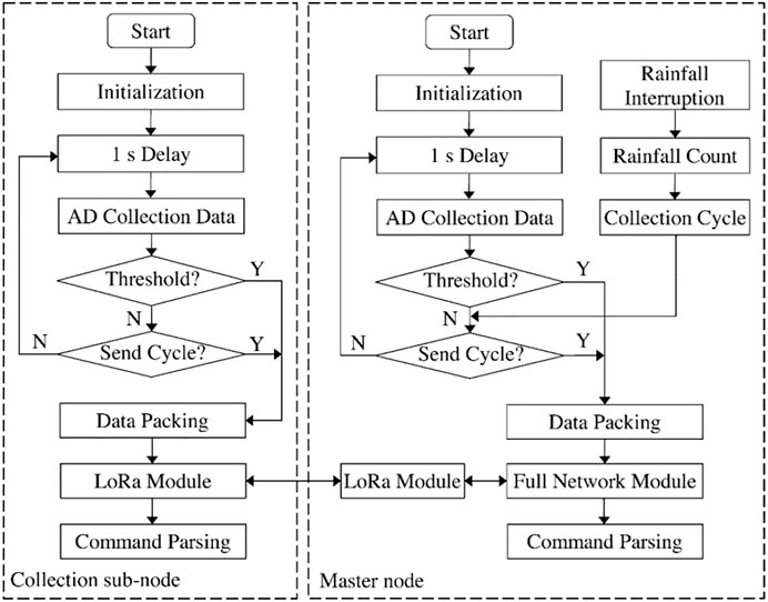
The proposed system uses the main node and sub-node to build the landslide wireless ad-hoc network, which can support three data acquisition methods: timing acquisition, broadcast acquisition, and threshold trigger acquisition. A single-to-many mapping relationship is established between the main node and the sub-node when the field wireless ad hoc network is established. The master node and the sub-node form a local self-organizing network through the LoRa communication protocol for landslide monitoring, and collect data from the rainfall, crack displacement, and other monitoring sensors. Figure 9 illustrates the flow chart of the master node and sub-node ad-hoc network.
4.3 Software Design of the Host Computer
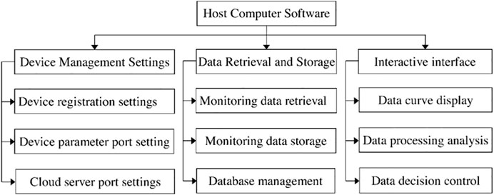
The geological disaster monitoring and early warning information management platform is used to store, display, query, analyze, and process the collected on-site monitoring data. The host computer software is realized using the Visual Studio development platform, and the corresponding software modules are developed through the C#.Net form application. The platform mainly includes equipment management settings, data retrieval and storage, human-computer interaction interface, and other functions. Figure 10 presents the host computer function module diagram.
4.4 Low-Power Software Design
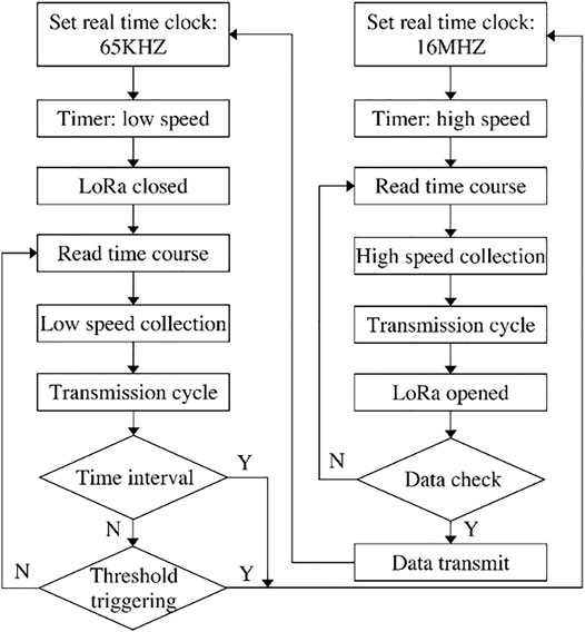
Geological disaster monitoring equipment is generally installed in dangerous areas with adverse disaster body deformation or in areas where manual work is inconvenient. The normal operation of the equipment is primarily focused on the power supply and communication networks. Figure 11 presents the flow chart of the low power collection sub-node software. The proposed system presents the low power consumption software design to solve the network transmission of wireless ad-hoc networks by proposing two work modes: the frequency conversion working mode and the collection trigger mode (Somchai et al., 2016; Wang and Zhu, 2020). When the equipment is operated in the normal mode, the main frequency of the microcontroller is reduced from 16 MHz to 65 kHz, which ensures that the equipment can be operated in each function module at a low speed, while closing the communication interface. In the collection trigger mode, the device data collection interface is in the low-speed real-time monitoring mode. The result of the collected data exceeds the present threshold when there is an abrupt change in one of the multiple monitoring parameters; the device is immediately activated and enters the high-speed operation mode. The system simultaneously opens the communication interface and sends the variation value collected by the sub-master node to the remote geological disaster monitoring and early warning cloud server. The system enters a low-speed operation mode when it is confirmed that the data is sent successfully. In low speed operation mode, the working current of the device can be as low as 1 mA. This design ensures that the power supply capacity of the equipment is maintained without losing useful data.
5 Test Analysis
5.1 Deployment of Monitoring Equipment
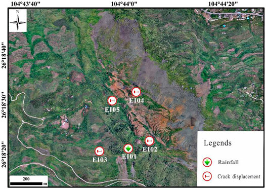
The Jianshanying disaster area in the Shuicheng County of the Guizhou Province is selected as the landslide disaster testing site, and the function of the landslide monitoring system is analyzed. This area is characterized by complex terrain, large and diverse damage area, scattered debris, cracks, and other characteristics. Five sets of equipment, numbered EI01 ∼ EI05, are built in this region. EI01 is used as the gateway master node to monitor the rainfall, and EI02 ∼ EI05 are used as the collection sub-nodes to monitor the deformation of surface cracks at four key disaster points (Figure 12).
5.2. Test Data
The monitoring data of nearly 9 months, from 15 December 2019, to 10 September 2020, are selected for data analysis. The interval of timed return in the working mode of the system is 1 h. The data collection port is simultaneously turned on to trigger the return mode, and the thresholds for rain trigger and displacement trigger return are set to 0.2 and 20 mm, respectively.
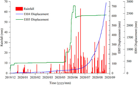
It can be observed from the data that the landslide monitoring system based on LoRa obtains real-time monitoring data of landslide rainfall and displacement sensor changes, and presents a comparative analysis of the displacement and deformation of cracks in the landslide, as shown in Figure 13. The red column represents landslide rainfall monitoring data, the green curve represents landslide EI05 displacement monitoring data, and the blue curve represents landslide EI04 displacement monitoring data.
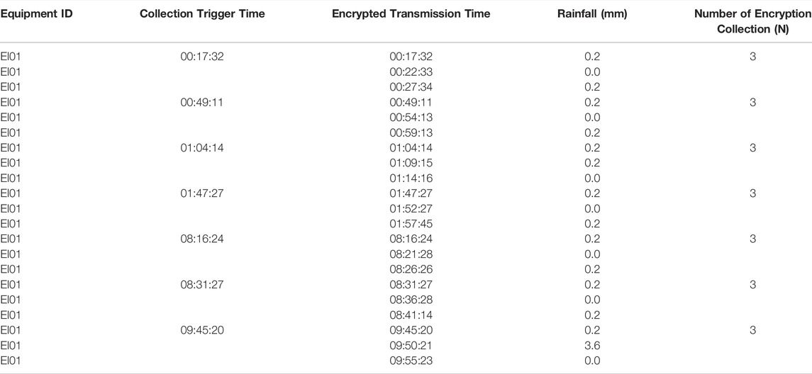
The rainfall and displacement are primarily analyzed to achieve adaptive encryption data collection. There was intermittent rainfall at the Jianshanying disaster site in Shuicheng County from January 4 to 10 January 2020. Each rainfall triggers the encryption collection and return of the master node EI01 device, and the encryption returns three pieces of data each time. The encrypted collection interval is 5 min. It is can be observed that the fracture displacement presents an increasing trend under the coupling effect of rainfall, and the fracture displacement varies significantly under the condition of heavy rainfall.
5.3 Results Analysis
Through the monitoring data, it can be concluded that the designed monitoring system can well capture the displacement change of landslide cracks. The EI01 device triggered the collection and return mechanism several times when it started raining at 0:17 on 6 January 2020. The return interval is approximately 5 minutes (Table 3). If it is triggered again in the process of the three encrypted returns, the trigger condition is ignored, and the trigger data are counted into the next 5 minute cycle.
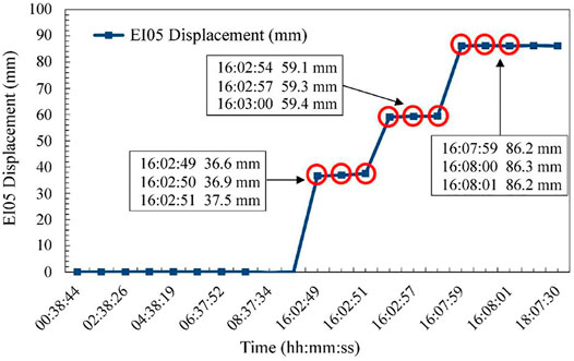
In addition, the real-time collection and backhaul of the displacement collection sub-node is high. The encrypted collection and backhaul interval after each trigger is 1 s, and the encrypted backhaul is performed thrice. According to the analysis of the returned data, the displacement monitoring points, EI02 and EI03, are relatively stable, and there is no displacement change as of 10 September 2020. However, the displacement of the EI04 and EI05 displacement monitoring points varies significantly as shown in Figure 13. Figure 14 presents one case that proves the accuracy of adaptive data transmission.
The EI05 displacement monitoring point recorded a sudden change on 15 December 2019, and the displacement change reached 86.2 mm in a short period of time. The EI05 monitoring point detected a sudden change of displacement data from 0 to 36.6 mm at 16:02:49 on 15 December 2019, exceeding the preset threshold of 20 mm, triggering the return mechanism and collecting once every 1 s, presenting a total of Pass three pieces of data. Since the device has not entered the low power consumption mode within a short period, the data mutation was again recorded to reach 59.1 mm at 16:02:54, exceeding the threshold of 20 mm, and the retransmission mechanism was triggered again with only an interval of 3 s. At 16:07:59, the data abruptly changed to 86.2 mm, and the changes of surface cracks were accurately captured thrice.
According to the preliminary investigation and on-site installation of the equipment, the EI04 equipment was installed in the landslide crushing zone and the EI05 equipment was installed at the trailing edge of the landslide. The two monitoring points were relatively unstable, and the consistency of the data changes was verified simultaneously.
6 Conclusion
This study proposes an IoT architecture for landslide monitoring using a LoRa network. The design of the overall structure and the software and hardware design scheme of intelligent perception monitoring technology are explained in detail. The findings of the study are presented below:
1) This study presents a novel solution for landslide monitoring, which meets the technical requirements of landslide geological disaster data acquisition to solve the problem of poor network communication in complex mountain field environments. An embedded microcontroller, a LoRa ad-hoc network, and 4G network technology are used to realize the real-time dynamic monitoring of landslides.
2) The proposed system presents flexible operation by using single chip frequency control, low speed monitoring of data acquisition port, and trigger return of monitoring threshold, which effectively controls the power consumption of the system to a certain extent and ensures the power supply of the field monitoring equipment.
3) The wireless ad-hoc landslide monitoring system proposed in this paper can effectively solve the system power consumption and communication transmission problems. It can realize long-distance sensor networking and data interconnection in the landslide monitoring range, and ensure the stability, and real-time and reliable upload of field monitoring data.
4) The geological disaster monitoring and early warning information management platform can be used to immediately understand and view the deformation data of landslides, and can also provide an effective technical reference for geological disaster management personnel and emergency experts in order to minimize casualties and property loss.
Although the designed monitoring system has achieved a good design effect, further research is needed to ensure that the system can work more stably and reliably.
1) In the system software work, it is necessary to improve the accuracy of data acquisition. Currently, second-level acquisition frequency has been achieved, and the next step is to achieve millisecond sampling accuracy.
2) The influence of external factors on the monitoring system should also be considered, mainly referring to the interference of LoRa’s transmission signal, because in the actual monitoring, there will be heavy rainfall, fog and tree cover, etc.
3) The results show that for a certain range of landslides, the LoRa ad hoc network reflects the advantages of wireless sensor networks, but for larger-scale and larger-volume landslides, it needs to be further verified, and additional relays may be required to realize the efficient transmission of data.
Data Availability Statement
The original contributions presented in the study are included in the article/Supplementary files, further inquiries can be directed to the corresponding author.
Author Contributions
conceptualization, CW and QM; methodology, CW, WG, and QM; validation, WC, WG, and QM; formal analysis, CW, WG, KY, XW, and QM; investigation, CW, WG, and QM; resources, CW, WG, KY, and QM; data curation, CW, WG, XW, and QM; writing—“original draft preparation, CW, WG, and QM; writing—”review and editing, CW, WG, and QM; supervision, CW, and QM; project administration, CW, and QM; All authors have read and agreed to the published version of the manuscript.
Conflict of Interest
The authors declare that the research was conducted in the absence of any commercial or financial relationships that could be construed as a potential conflict of interest.
Publisher’s Note
All claims expressed in this article are solely those of the authors and do not necessarily represent those of their affiliated organizations, or those of the publisher, the editors and the reviewers. Any product that may be evaluated in this article, or claim that may be made by its manufacturer, is not guaranteed or endorsed by the publisher.
Acknowledgments
This work was supported by National Key Research and Development Program of China (No. 2019YFC1509601), Geological Survey Projects of China Geological Survey (No. DD20221747 and No. DD20190639).
References
AhmedMoyed, M. M., Narsimhulu, G., and Sreenivasa Rao, D. (2019). Instrumentation for Measurement of Geotechnical Parameters for Landslide Prediction Using Wireless Sensor Networks. Soft Comput. Signal Process. 898, 437–445. doi:10.1007/978-981-13-3393-4_45
Adeel, A., Mandar, G., Saadullah, F., Ieracitano, C., Dashtipour, K., Larijan, H., et al. (2019). A Survey on the Role of Wireless Sensor Networks and IoT in Disaster Management. Geol. Disaster Monit. Based Sens. Netw., 57–66. doi:10.1007/978-981-13-0992-2_5
Azzam, R., Arnhardt, C., and Fernandez-Steeger, T. M. (2010). Monitoring and Early Warning of Slope Instabilities and Deformations by Sensor Fusion in Self-Organized Wireless Ad-Hoc Sensor Networks.Pdf. J. SE Asian Appl. Geol. 2 (3), 163–169. doi:10.22146/jag.7259
Cui, Y., Liu, H., Zhang, M., Stankovski, S., Feng, J., Zhang, X., et al. (2018). Improving Intelligence and Efficiency of Salt Lake Production by Applying a Decision Support System Based on IOT for Brine Pump Management. Electronics 7 (8), 1–22. doi:10.3390/electronics7080147
Dong, H., and Huang, S. (2017). Design and Implementation of Intelligent Agriculture System Based on LoRa Technology. Inf. Techology Netw. Secur. 36 (22), 106–108. doi:10.19358/j.issn.1674-7720.2017.22.028
Du, K., and Liu, S. (2019). Design of LoRa-Based Real-Time State Monitoring System for Laboratory Equipment. Mod. Electron. Tech. 42 (24), 46–49. doi:10.16652/j.issn.1004-373x.2019.24.011
Intrieri, E., Giovanni, G., Francesco, M., Fanti, R., Casagli, N., et al. (2012). Design and Implementation of a Landslide Early Warning System. Eng. Geol. 147-148, 124–136. doi:10.1016/j.enggeo.2012.07.017
Giri, P., Ng, K., and Phillips, W. (2019). Wireless Sensor Network System for Landslide Monitoring and Warning. IEEE Trans. Instrum. Meas. 68 (4), 1210–1220. doi:10.1109/tim.2018.2861999
Giorgetti, A., Matteo, L., Emanuele, T., Barla, M., Gigli, G., Casagli, N., et al. (2016). A Robust Wireless Sensor Network for Landslide Risk Analysis: System Design, Deployment, and Field Testing. IEEE Sensors J. 16 (16), 6374–6386. doi:10.1109/jsen.2016.2579263
Guan-Peng, F., Li, Y-J., and Wang, Y-J. (2020). Design of Monitoring System for Partial Discharge Based on Ultrasonic Sensor and STM32. Instrum. Tech. Sens. (6), 55–58. doi:10.3969/j.issn.1002-1841.2020.06.013
Han, W., Yao, X., and Huang, X. (2020). Monitoring System of Photovoltaic Power Station Based on LoRa. Instrum. Tech. Sens. (6), 59–62. doi:10.3969/j.issn.1002-1841.2020.06.014
Haziel, L., Andrias Izaac, L., Abdi, W., and Alaydrus, M. (2018). Wireless Sensor Network Design for Earthquake’s and Landslide’s Early Warnings. Indonesian J. Electr. Eng. Comput. Sci. 11 (2), 437–445. doi:10.11591/ijeecs.v11.i2.pp437-445
Jeong, S., Ko, J., and Kim, J. (2020). The Effectiveness of a Wireless Sensor Network System for Landslide Monitoring. IEEE Access 8, 8073–8086. doi:10.1109/access.2019.2960570
Kay, S., Kristina, G., and Markus, K. (2014). An Internet-Enabled Wireless Multi-Sensor System for Continuous Monitoring of Landslide Processes. Int. J. Eng. Technol. 6 (6), 520–529. doi:10.7763/ijet.2014.v6.752
Kumar, S., Duttagupta, S., Rangan, V. P., and Ramesh, M. V. (2019). Reliable Network Connectivity in Wireless Sensor Networks for Remote Monitoring of Landslides. Wirel. Netw. 26 (3), 2137–2152. doi:10.1007/s11276-019-02059-7
Lorenzo, G., Vanni, M., Giuseppe, B., Rugini, L., and Frescura, F. (2019). An IoT Architecture for Continuous Livestock Monitoring Using LoRa LPWAN. Electronics 8 (12), 1–28. doi:10.3390/electronics8121435
Martina, S., Michael, K., Michael, B., and Straub, D. (2015). Forecasting Rock Slope Failure: How Reliable and Effective Are Warning Systems? Landslides 13 (4), 737–750. doi:10.1007/s10346-015-0605-2
Ramon, S-I., Ignacio, G. L., Christian, S., Couñago, E., and Skarmeta, A. (2018). Tracking and Monitoring System Based on LoRa Technology for Lightweight Boats. Electronics 8 (1), 1–18. doi:10.3390/electronics8010015
Sandra, S., Laura, G., Jaime, L., Bosch, J., and Vega-Rodríguez, R. (2020). LoRaWAN Network for Fire Monitoring in Rural Environments. Electronics 9 (3), 1–29. doi:10.3390/electronics9030531
Shruti, N., Sajinkumar, K. S., Thomas, O., Anuja, V. J., Samuel, R. A., Muraleedharan, O., et al. (2018). Early Warning System for Shallow Landslides Using Rainfall Threshold and Slope Stability Analysis. Geosci. Front. 9 (6), 1871–1882. doi:10.1016/j.gsf.2017.10.008
Somchai, B., Boonyang, P., and Sriwichai, S. (2016). Development of Low Cost Vibration Sensor Network for Early Warning System of Landslides. Energy Procedia 89, 417–420. doi:10.1016/j.egypro.2016.05.055
Wan, X., Cui, J., Yang, Y., Jiang, X., and Sohail, S.M, (2018). Research on Transmission Measurement System for LoRa Wireless Underground Sensor Network. J. South China Agric. Univ. 39 (3), 118–124. doi:10.7671/j.issn.1001-411X.2018.03.018
Wang, P., and Zhu, C. (2020). Design of Wireless Battery Monitoring System with Low Power Consumption Based on STM32. Electr. Meas. Instrum. 57 (6), 114–119. doi:10.19753/j.issn1001-1390.2020.06.018
Wu, L., and Sun, Y. (2020). Design of Long-Distance Monitoring System for Bridge Cable Force Based on Lora. Comput. Eng. Softw. 41 (1), 216–219. doi:10.3969/j.issn.1003-6970.2020.01.047
Yin, Y., Wang, F., and Sun, P. (2009). Landslide Hazards Triggered by the 2008 Wenchuan Earthquake, Sichuan, China. Landslides 6 (2), 139–152. doi:10.1007/s10346-009-0148-5
Zhang, M., and Zhou, Z. (2019). Design of Remote Monitoring System Based on LoRa. Transducer Microsyst. Technol. 38 (7), 95–98. doi:10.13873/J.1000-9787(2019)07-0095-04
Zhang, Y., Chen, X., Liao, R., Wan, J-L., He, Z-Y., Zhao, Z-X., et al. (2021). Research on Displacement Prediction of Step-type Landslide under the Influence of Various Environmental Factors Based on Intelligent WCA-ELM in the Three Gorges Reservoir Area. Nat. Hazards 107, 1709–1729. doi:10.1007/s11069-021-04655-3
Keywords: Landslide monitoring, Internet of Things, Wireless Sensor Networks, LORA, adaptive data collection
Citation: Wang C, Guo W, Yang K, Wang X and Meng Q (2022) Real-Time Monitoring System of Landslide Based on LoRa Architecture. Front. Earth Sci. 10:899509. doi: 10.3389/feart.2022.899509
Received: 18 March 2022; Accepted: 23 May 2022;
Published: 06 June 2022.
Edited by:
Thomas Oommen, Michigan Technological University, United StatesReviewed by:
Sajinkumar KS, University of Kerala, IndiaTejo Bheemasetti, South Dakota School of Mines and Technology, United States
Sujatha Evangelin Ramani, SASTRA University, India
Copyright © 2022 Wang, Guo, Yang, Wang and Meng. This is an open-access article distributed under the terms of the Creative Commons Attribution License (CC BY). The use, distribution or reproduction in other forums is permitted, provided the original author(s) and the copyright owner(s) are credited and that the original publication in this journal is cited, in accordance with accepted academic practice. No use, distribution or reproduction is permitted which does not comply with these terms.
*Correspondence: Qingjia Meng, bWVuZ3FpbmdqaWFAbWFpbC5jZ3MuZ292LmNu
 Chenhui Wang
 Wei Guo1,3