
94% of researchers rate our articles as excellent or good
Learn more about the work of our research integrity team to safeguard the quality of each article we publish.
Find out more
ORIGINAL RESEARCH article
Front. Earth Sci., 29 September 2022
Sec. Geohazards and Georisks
Volume 10 - 2022 | https://doi.org/10.3389/feart.2022.877161
This article is part of the Research TopicIntegrated Disaster Risk Management: From Earth Sciences to Policy MakingView all 17 articles
 Pascal Lièvre1†
 Eléonore Mérour1*†
 Julie Morin2Luisa Macedo Franco3Domingo Ramos Palomino4Marco Rivera Porras3Pablo Masías Alvarez4Benjamin van Wyk de Vries5
This paper proposes a new way of understanding the debate between vulnerability and resilience. We mobilize on the theoretical level the notion of “paradigm” in the sense of Kuhn and, on the methodological level, Foucault’s notion of “apparatus” to understand volcanic risk management practices. Through an interdisciplinary approach, combining management, geography and Earth sciences, we study the evolution of volcanic risk management practice in Arequipa (Peru) from the 1990s to the present. To do this, we look at the history of volcanic risk management in Arequipa, using a qualitative interview methodology based on six in-depth centered interviews from the main actors of this history, supported by a 2-month ethnography which allowed access to large institutional documentation (reports, studies, archives, maps, pictures...). Management practices in Arequipa appear to be centered on the paradigm of vulnerability since the 1990s. Some operations since 2015 named as resilient emerge but they are still inscribed in the vulnerability paradigm. The results show the relevance of the theoretical and methodological framework chosen for Arequipa but also the possibility of using it in a more general way.
The purpose of this paper is to make a theoretical proposal to account for volcanic risk management practices through an interdisciplinary approach combining management, geography and Earth sciences. We note on the one hand a deficit of theorization around “management practices” in the field of Earth sciences (Donovan and Oppenheimer, 2014) and on the other hand a difficulty in distinguishing and articulating practices in reference to the concepts of vulnerability and resilience.
Volcanic risk management practices are associated with the notion of vulnerability and/or resilience, which are relatively intertwined and connected notions as expressed by Cutter et al. (2008). To clarify the debate, we approach the interaction between vulnerability and resilience from the notion of paradigm in the sense of Thomas Kuhn (1972), considering that within each paradigm, there is always “a point of view on the world” beyond the theoretical part. The passage from one paradigm to another paradigm is always a radical change of point of view capable of better integrating a number of questions posed by the previous paradigm. Thus, it is possible to propose a reading grid of the two paradigms by pair of contrasts. The multiplication of works on vulnerability and resilience, but also of the links between them in the field of volcanic risk management, makes a conceptual clarification necessary.
Recent studies also note the lack of literature to articulate practices in relation to vulnerability and resilience (Miller et al., 2010; Fekete et al., 2014). To answer this deficit, we refer to a new current of research in social sciences centered on practice from the seminal works of Foucault (2001; 2009), Giddens (1979), Bourdieu (1972) and Latour (2006). Based on a narrative on the history of volcanic risk management in Arequipa, we highlight local risk management practices and their arrangement in an apparatus, considered as a methodological tool. We approach the notion of “apparatus” in the sense of Foucault (2001), extended in organization and management sciences (McKinlay and Starkey, 1998; Gilbert and Raulet-Croset, 2021). We use the notion of apparatus as a methodological tool to understand management practices as a set of heterogeneous elements such as theoretical frameworks, tools, institutions, places, etc. These social and material elements are linked together in order to obtain a performance (Foucault, 2001). This way of understanding practices is close to the theory of assemblage in the geography of risk (Donovan, 2017) which is based on the work of Latour (2006).
First, we review the links between vulnerability and resilience through the notion of “paradigm” in the sense of Kuhn (1972) to clarify the transition from vulnerability to resilience. Secondly, we present the context of Arequipa and the methodology through the notion of apparatus (Foucault, 2001). In the third part, we present the factual evolution of volcanic risk management practices in Arequipa, Peru, as close as possible to the categories constructed by the stakeholders since the 1990s. In a fourth step, we test our theoretical grid to interpret this history. In a conclusion, we identify the main contributions of this work, the related limitations and future perspectives.
Volcanic risk management practices are associated with the notion of vulnerability and/or resilience, which are relatively related, intertwined, and connected notions as expressed by Cutter et al. (2008). To clarify, we proposed to approach the interaction between these two notions from the notion of paradigm in the sense of Kuhn, considering that within each paradigm there is always beyond the theoretical part “a point of view on the world,” and that the passage from one paradigm to another paradigm is always a radical change of point of view able to better integrate a number of questions posed by the previous paradigm. Thus, it was possible to propose a reading grid of the two paradigms by pair of contrasts.
We mostly rely on the literature in geography on the concepts of vulnerability and resilience in their approach to natural or technological hazard management. This literature is very large, in terms of the number of articles published over the last 40 years (Barroca et al., 2013, see Figure 1). It is also extremely complex (Morin, 2008) in the sense that contradictory and opposing logic emerges, while links are also proposed between the literature on the two concepts (Fuchs and Thaler, 2018). As Cutter (2018:257) reminds us, “Vulnerability and resilience are well known and often discussed concepts in disaster research. Depending on the disciplinary, methodological, or philosophical perspective, these two concepts have very distinct and contested meanings and research traditions.”.At the same time, many researchers propose to establish links between these two concepts (i.e. Adger, 2006; Folke, 2006; Cutter, 2006; Gallopín, 2006; Turner, 2010; Miller et al., 2010; Cutter, 2018). Some even speak of a continuum between these two approaches by suggesting “social vulnerability” as a bridge between the two (Cutter, 2006; Miller et al., 2010; Provitolo, 2010).
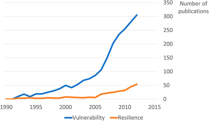
FIGURE 1. Geography publications with “vulnerability” or “resilience” in their title, based on data available on Web of Science (reproduction from Barroca et al., 2013).
We approach the debate between vulnerability and resilience in geography from the notion of paradigm in the sense of Kuhn (1972): a succession of paradigms that each time constitute “a new world view,” combined with a theoretical corpus, methods, emblematic cases, indicators, etc. One can understand a previous paradigm one from the point of view of a new paradigm 2, but not vice versa. Kuhn (1972) defends the idea of the relevance of paradigms in the development of science, as they allow a community to focus on a certain type of problems and solutions.
We suggest a reading of the debates between vulnerability and resilience from a paradigm point of view. Thus, we consider vulnerability as the first paradigm, which proposes to address the issue of so-called “natural” risk management and which has been constructed since the 1970s. White (1974), geographer at the University of Chicago, appeared as the precursory proponent of this approach, which was to become the dominant paradigm in the 1990s (Cutter, 1996; Dauphiné 2001; Adger, 2006). The emergence of the resilience paradigm in the 2000s can be understood as a response to the problems faced by the vulnerability paradigm. It is in this way that we interpret the work of Alexander (2013) in his etymological journey around resilience. The concept comes from ecology and psychology and challenges social science (and geographic approaches) to risk reduction by proposing a new approach. Other researchers also considered this evolution (Dauphiné and Provitolo, 2007; Barroca et al., 2013; Tomassi, 2018). At present, both paradigms are not equally mature, and the resilience paradigm is still in an exploratory stage compared to the vulnerability paradigm, as can be seen from the quotes below:
“To reduce the damage from disasters, practitioners have for centuries proposed a strategy to improve the resistance of societies to a hazard. They calculate increasingly precise predictable magnitudes of the hazard, and then persuade officials to build defensive equipment to protect society. Following this strategy, they built dykes along rivers and then dams upstream against flooding. Anti-seismic measures are also part of this approach, effective when the precise impact of the hazard can be predicted. However, this situation is exceptional. There are many reasons why it is often impossible to obtain accurate results and therefore to properly calibrate structures. It is then possible to adopt another strategy based on the concept of resilience. This second strategy aims, not to oppose the hazard, but to reduce its impacts as much as possible.” (Translated from Dauphiné and Provitolo, 2007:115–125).
“At the turn of the millennium, after having put forward the concept of vulnerability, resulting from the politicization of risk and disaster studies during the 1970s, risk management was enriched by a new notion, that of resilience. This concept has enabled us to renew the way in which we conceive the relationship between urban society and risks (natural or technological) in a context of climate change, high uncertainty and increasing number of disasters. At a time when we thought we had mastered natural hazards thanks to technology, the latter revealed its unthinkable aspects and the fragility that accompanies it. Sometimes seen as the positive side of vulnerability, resilience is an integrative notion with a fairly broad meaning that concerns not only the capacities of a social group and/or a territory (or, more broadly, a socio-technical or ecological system, etc.) to cope with a disaster, but also its ability to recover from this disruption and turn it into an “opportunity.”” (Translated from Tomassi, 2018:1).
As these two extracts show, it is in the face of imprecise, or unmeasurable risk predictions that resilience emerged as another way of approaching risk management from what we must call uncertainty. An important distinction must be made between the notion of risk and that of uncertainty. Vulnerability is based on a classical vision of risk, i.e., a potential danger whose probability of occurrence can be calculated objectively and historically (Fischhoff et al., 2011). In this perspective, uncertainty is ultimately understood as risk and if objective probabilities are not possible to know, subjective probabilities will be mobilised, using the point of view of experts, making a reduced distinction or merging these two without making any logical distinction between these two categories. Taking the limitations of this approach to risk as our starting point, we will explore uncertainty in order to address the new perspective of resilience. This is a “radical uncertainty” in the sense of Knight (1921), and Callon et al. (2009) point out, that the notion of uncertainty can be understood more precisely in terms of the unknown, i.e., “the only thing we know is that we do not know.” Therefore, an improvement of the overall resilience of a system is to improve its ability to cope with the unknown, i.e., with situations that cannot be anticipated. These two perspectives, a risk-based approach to vulnerability and an uncertainty-based approach to resilience, represent a radical theoretical opposition in the way risk management is approached. This radical opposition between risk and uncertainty has been tackled head-on by economists and sociologists such as Dupuy and Grinbaum (2005) and Callon et al. (2009).
Barroca et al. (2013) suggest presenting vulnerability and resilience as two opposing perspectives, although there is also work that tends toward the unification of the two concepts. Vulnerability is centred on a state of fragility of a territory in reference to a potential danger, from an analytical perspective, and the resilience on a capacity to cope and learn from a potential danger, from a systemic and complexity perspective. We have retained from Barroca et al. (2013) the opposition of vulnerability and resilience, employing on one hand, an analytical approach and, on the other, a systemic approach based on the work of Le Moigne (1977).
We propose to account for the debate between vulnerability and resilience paradigm as an opposition between two world views that can be radically opposed in terms of definition, basic principle, approach, starting point, nature of the solution, characterization of the approach, focus and finally in their problems and limitations.
We retain the definition proposed by Kelman et al. (2015) in their article, where they borrowed from the work of the IPCC 2013-2014. Vulnerability is, “The propensity or predisposition to be adversely affected. Vulnerability encompasses a variety of concepts including sensitivity or susceptibility to harm and lack of capacity to cope and adapt.” We retain two basic elements 1) “a propensity to be adversely affected” by something potentially dangerous and 2) an inability to cope. This is a static state of fragility. This idea is reflected in the benchmark paper of Adger (2006): “Vulnerability is the state of susceptibility to harm from exposure to stresses associated with environmental and social change and from the absence of capacity to adapt.” Resilience is defined as The capacity of a social-ecological system to cope with a hazardous event or disturbance, responding or reorganizing in ways that maintain its essential function, identity, and structure, while also maintaining the capacity for adaptation, learning, and transformation. We retain two important elements which make resilience appear the opposite of vulnerability as: 1) “the capacity (...) to cope with a potentially dangerous situation” (p. 132, Kelman et al., 2015), and 2) the ability to learn from this event. It is a dynamic capacity to learn. We propose a comparison of these two concepts below (see Table 1).
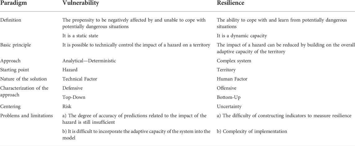
TABLE 1. The contrasts between the paradigms of vulnerability and resilience.
The vulnerability paradigm is based on a basic principle: it is technically possible to control the impact of a hazard on a territory. It is an analytical and deterministic approach. The starting point of the analysis is the study of the hazard and its probability of occurrence, and the ability to assess the probability of the hazard causing damage to the area. The solution is technical. It is a defensive, top-down approach, centered on a classic risk approach. This perspective poses problems of two kinds: 1) the degree of precision of the forecasts related to the impact of the hazard often appears insufficient and the reality deviates from the established scenarios, 2) it is difficult to integrate into the model the adaptive capacity of the system.
The resilience paradigm is based on a basic principle: the capacity of a territory to adapt can reduce the impact of a hazard. The starting point of the analysis is the study of the characterization of the socio-technical system that constitutes the territory. It is a complex system approach. The solution is based on the capacities of individuals, groups and the territory to deal with the actual situation. It is an offensive, bottom-up approach, centered on an approach to uncertainty (Callon et al., 2009). The problems encountered by this perspective are twofold: the difficulty of constructing indicators for measuring resilience and the complexity of implementing them.
We will continue the discussion on the relationship between the two paradigms in terms of their complementarity or their substitution with possible integration or replacement by complete rupture. As recommended by some authors (Miller et al., 2010; Fekete et al., 2014), we aim to provide a new way to link the vulnerability and resilience paradigms to their effective practices by applying them in a specific territory: the city of Arequipa in Peru.
Arequipa is a city of 1.1 million inhabitants in southern Peru (INEI, 2018), with a historical centre listed as UNESCO World Heritage, and city outskirts rapidly expanding, with informal urbanization, into areas exposed to geological, seismic, and hydro-meteorological hazards. Arequipa is framed by three large volcanoes: Chachani, El Misti and Pichu Pichu. El Misti is active and constitutes a probable eruption threat for the city, Chachani is potentially active, and all three volcanoes host a major risk of torrential floods and lahars (volcanic debris flows). We illustrate the volcanic context and some risk reduction measures below (see Figure 2).
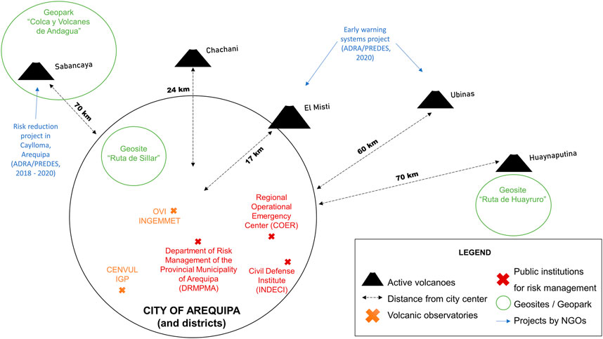
FIGURE 2. Volcanic context and risk management stakeholders in and around Arequipa.
El Misti erupted last in 1440–1470 AD (Thouret et al., 1995) and has a 2000–4000-years highly hazardous Plinian eruptive cycle (Cobeñas et al., 2012). The volcano currently exhibits only slight gas plumes and is not an immediate hazard. However, the numerous ravines originating from El Misti and that cross the city of Arequipa are major features in terms of risk in Arequipa, as the city experiences destructive events related to torrential rains almost every year. The monopolization of attention on these hazards that occur annually counter-intuitively hinders risk awareness about a potential eruption, even though such events should raise attention to the lahars that would be induced in the event of a large eruption by the remobilization of freshly deposited volcanic material (Sandri et al., 2014).
Less than 75 km northwest of Arequipa, two other volcanoes are currently erupting, and have been doing so regularly for the past 30 years: the Sabancaya volcano (70 km northwest) and the Ubinas volcano (about 60 km east, in the Moquegua province). Like El Misti, they are continuously monitored by the Geophysical Institute of Peru (IGP) and the Volcanic Observatory of the Geology, Mining and Metallurgy Institute (OVI-INGEMMET). Risk management programs around volcanoes in southern Peru involve different stakeholders, such as: the Regional Operational Emergency Center (COER), the National Institute of Civil Defense (INDECI), the National Center for Disaster Risk Estimation, Prevention and Reduction (CENEPRED) and the Department of Risk Management of the Provincial Municipality of Arequipa (DRMPMA).
Since 2014, all of these stakeholders have been part of the national disaster risk management system (SINAGERD). The COER is in charge of coordinating emergency risk management at the regional level, and the INDECI relies on it to act operationally in helping the population before, during and after disasters. The DRMPMA is in charge of all the work and training to be done on the culture of risk management in its provincial territory, which includes the city of Arequipa and its districts. In this paper, we propose to document the different volcanic risk management practices in Arequipa in the last 30 years.
We chose a qualitative methodology to approach the stakeholders’ volcanic risk management practices as closely as possible in situ in order to document the links that unite them to vulnerability and resilience paradigms. We made a literature review on the vulnerability and resilience paradigms in geography to better understand the theoretical discussion and analyze their influence on policies and regulations in Arequipa. To approach the notion of practice theoretically, we rely on the growing body of seminal work in the contemporary social sciences around Foucault (2001), Foucault (2009); Giddens (1979), Bourdieu (1972), and Latour (2006). It is a real turning point in the field of social sciences. The book directed by Schatzki et al. (2001) constitutes an important step in this direction, it is through practices (which include actions and interactions) that we can understand the organization, reproduction and transformation of social life. This perspective has given rise to important developments in the field of management science via what is known as the Strategy-As-Practice (SAP) current (Whittington, 1996; Jarzabkowski, 2003; Golsorkhi et al., 2010; Fenton and Langley, 2011; Rouleau, 2013; Whittington, 2017).
To approach volcanic risk management practices, we did an ethnographic investigation in residence in the main volcanic observatories (Geophysical Institute of Peru (IGP) and the Volcanic Observatory of the Geology, Mining and Metallurgy Institute (OVI-INGEMMET) between January and March, 2020. This led to the writing of a field diary (100 pages) and six in-depth centered interviews.
For these interviews, we selected historical actors from IGP, INGEMMET, and LMV who lived the early times of the work done in Arequipa (around 1994–2002). They were anonymous and their average duration was around 50 min. We conducted our interviews with an approach centered on the historical, chronological and living experiences of the interviewees to allow them to produce a fluid discourse (Morris, 2015) while we addressed several themes during the conversation: materiality and symbolism around the volcano, volcanic risk management, political and media stakes, the way scientist and institutions are perceived, and their experience of a lived extreme event i.e., a disaster or a crisis. This method seems particularly suited to the construction of a narrative from the stories lived by the actors because it produces “a way of knowing” (Seidman, 2006).
Interviews were analyzed with a grounded theory approach (Glaser and Strauss, 2017) using a constant comparison analysis to select the different activities reported and to code them as practices. This coding allowed the emergence of indigenous categories (“risks awareness center,” “volcanic eruption simulation,” etc.) that represent practices developed in Arequipa. We do not pretend to list exhaustively all the practices observed in Arequipa but we highlight those that have been major steps in improving risk management. Obviously, the choices made are not of the order of establishing a hierarchy of values, but of a will to show the variety of practices in an objective synthesis.
We collected a rich documentation that have helped us to triangulate the data and chart the progression of ideas on how to deal with the negative effects of volcanic and other associated hazards (i.e., lahars, hail, snow, earthquakes). This is done by following the scientific literature specifically focused on Arequipa from the 1990s and reports from governmental bodies, such as geological surveys (IGP, OVI-INGEMMET), observatories and civil defense. Such reports are considered the main local way of science communication.
We used all this documentation to reconstruct the history through a realist narrative approach, “to put ethnography on the intellectual and literary map” as described by Van Maanen (2011) and based on the proposition for a Foucaldian approach to narratives (Tamboukou, 2008). Throughout the narrative below, we factually reference all the management practices carried out by the actors around the monitoring and management of volcanic risks in Arequipa. We follow Foucault’s genealogical approach (2009) to illustrate the way these elements combine in a genealogical map and create an assemblage that fulfills a role in volcanic risk management.
Indeed, the notion of apparatus (Foucault, 2001; Foucault, 2009) is an assemblage that associates technical and social elements in the production of a performance. Management sciences have taken up this notion and adapted it for many years (McKinlay and Starkey, 1998; Gilbert and Raulet-Croset, 2021) to define a management apparatus as:
a) a set of heterogeneous elements,
b) which are linked together,
c) with the aim of producing a performance in relation to an activity.
The assemblage includes elements of different nature: stakeholders and institutions, theoretical frameworks, plans, events, projects, tools, places, etc. We will look at the practices in relation to theses elements which are crucial to developing volcanic risk management. The links between them make the performance of the system and may evolve during the history of the system. Based on these principles, two possibilities have been proposed: The Actor Network Theory (Latour, 2006) divides human and non-human actors, but we rely on the approach based on management instruments, which includes material and social elements in their assemblage (Gilbert and Raulet-Croset, 2021). This could eventually fit with the research field around Disaster Risk Management Assemblage (DRMA), a research current that proposes to approach Disaster Risk Management (DRM) from an assembly theory (Grove, 2013; Angell, 2014; Grove and Adey, 2015; Gillard et al., 2016; Donovan, 2017; Marks, 2019; McGowran and Donovan, 2021).
This methodology allows us to analyze practices around volcanic risk management in Arequipa and discuss them in relation to the vulnerability and resilience paradigm. This could eventually help stakeholders to review their experience around volcanic risk assessment and management in Arequipa from a reflective, historical and social perspective, as recommended by Gaillard (2010) to move away from a technocratic vision of disasters.
In the early 1990s, little was known about the eruptive potential of the volcanoes of southern Peru, although this area was considered one of the most dangerous in the world, also facing seismic and meteorological hazards (De Silva and Francis, 1991). Despite a series of studies conducted by a few researchers before the 1990s (Bullard, 1962; Hoempler, 1962; Gonzalez Ferran, 1990; Huaman-Rodrigo et al., 1993), volcanic monitoring was still in its infancy and risk management was almost very limited, but IGP started the volcanic monitoring of Sabancaya volcano between 1988 and 1994. A study conducted locally in Arequipa at the University of San Agustin (UNSA) provided the first basis of knowledge about the potential hazards of El Misti (Macedo, 1994; Masuno Kosaka et al., 2000). The arrival of Jean Claude Thouret (IRD) in 1995 (Thouret et al., 1995) in Arequipa started the first hazard assessment studies of the volcanoes: Ubinas, Huaynaputina, Ticsani, Misti, and the training of several volcanologists.
At the beginning of the 2000s, Peru was largely under-resourced in terms of human and organizational resources to deal with natural hazards, especially in southern Peru. The institutions such as INGEMMET and IGP, which operate volcano mapping and monitoring, were based in Lima and had no local Arequipa branch. The IGP installed a volcanology office in Arequipa in 1988, due to the reactivation of the Sabancaya volcano which continues to present. IGP thus began a temporary monitoring of volcanoes that developed slowly until 2004. Over this period, a telemetric seismic network was installed at El Misti in partnership with the French Institute for Development (IRD), and the Regional Government of Arequipa. The volcanoes gradually began to have monitoring equipment installed with help from foreign donations (such as from the USGS), but between the years 2000 and 2010, some of the institutions had great financial difficulties, preventing the development of their activities.
The geographers Degg and Chester (2005) proposed an initial history of this research, noting that there have been two major research agendas around vulnerability in Peru, and particularly in Arequipa: a first focused on physical factors related to vulnerability, and a second more integrated approach, led by Jean-Claude Thouret, aimed at considering the social factors in urban areas related to risk. A first agenda of research has helped to clarify the eruptive processes and hazards of different volcanoes in the region such as Sabancaya which erupted in 1990 (Thouret et al., 1994), and Huaynaputina which had a massive eruption in February 1600 AD (Juvigné et al., 1997), Ubinas volcano (Thouret et al., 2005) and El Misti volcano (Thouret et al., 1995; Thouret et al., 2001), which also erupted around 1440–1470 AD. Jean-Claude Thouret was primarily preoccupied with El Misti, since it looms over the city of Arequipa, threatening nearly one million inhabitants (as of 2001). He, therefore, introduced the second agenda of social vulnerability with Robert d’Ercole (D'Ercole et al., 1994; Thouret and D'Ercole, 1996; Thouret, 2002). The development context of Peru, with few means to cope with disasters, was highlighted and thus became one of the major issues of this paradigm.
In the wake of the work of Peruvian scientists and practitioners, the first operational project called “Eaux de source au Pérou” (EDSAP: “spring water in Peru,” Levieux et al., 2007) coordinated by Anthony Finizola (LMV), through the French based NGO “Volcan-Explor-Action” (VEA). The purpose of this project was to establish a first awareness center at the Museo Andino with the implementation of educational posters, still hung as of 2020.
A group of researchers from the USGS, UNSA, the University of Buffalo (Unites States), the National Autonomous University of Mexico (UNAM) and the LMV constructed an essential volcanology tool: the hazard map of El Misti volcano. The construction of the hazard map was intended to consider several types of hazards: 1) hazards related to pyroclastic flows on the slopes of the volcano, 2) hazards generated by ballistics and tephra, 3) hazards related to lahars, and finally 4) hazards related to possible rock avalanches caused by the collapse of a flank of the volcano. This hazard map was finalized and published in 2006 (Mariño et al., 2006). We will show that it became an important interface around which the stakeholders in charge of volcanic monitoring and then those of risk management in Arequipa gathered in the framework of their activities. In particular, it was mobilized for the organization of the first public event related to risk management: the first simulation of a volcanic eruption of El Misti in 2009 with the participation of all the stakeholders in charge of risk management (INDECI, COER, and DRMPMA) and the volcanic observatories of INGEMMET and IGP.
Since 2005, INGEMMET has organized seven international forums on volcanic risk (2005, 2006, 2007, 2008, 2010, 2013, and 2015) with an increasing number of presentations from foreign participants, both from southern and northern countries. They also started the monitoring of Ubinas volcano in 2006. The eruption of Ubinas volcano between 2006 and 2009 (in the region of Moquegua, bordering the Arequipa region) was a catalyst in the organization of the first volcanic eruption simulation in Arequipa (2009). Indeed, for the first time, stakeholders had to manage an eruptive crisis that threatened villages, and they managed to successfully evacuate inhabitants (Rivera et al., 2010), despite facing very complicated conditions (lack of staff, knowledge and organization of the authorities).
In 2011, the Risks Awareness Center1 opened in Arequipa to raise awareness of the various seismic, electrical and volcanic risks. The creation of the center is a decision of General Carlos Nacarino of the INDECI following the magnitude 8.4 earthquake that hit the city of Arequipa in 2001, and that left a deep trace in the memory of the inhabitants. It was intended for schoolchildren of the Province and reflects the dialogue that has been operated between a number of actors, as the development of the different educational rooms of the center was made through the participation of all actors in charge of monitoring and management of volcanic risks (INGEMMET, IGP, INDECI, COER, DRMPMA, and VEA).
After being hosted in the premises of the INDECI, with few resources to carry out its activities, INGEMMET inaugurated in 2013 its first volcanic observatory place in Arequipa and continued to work with LMV scientists on a second operational project with Peruvian school children called “Geoscientific communication problem with communities for disaster prevention and land planning in Peru” (Macedo et al., 2014).
In 2013, all the actors of risk management in Arequipa, COER, INDECI, DRMPMA, as well as the institutions in charge of volcanic monitoring (IGP, INGEMMET, UNSA) created a coordination platform for volcanic risk management, but its sustainability was difficult to maintain and raised many discussions. In 2014, Peru adopted its first plan for a national disaster risk management system (SINAGERD, 2014) that was implemented at different scales (national, regional, and local). This new structuration will permanently change the consideration of volcanic risk management in Peru, especially for Arequipa, by allowing a link between national risk management policies and their local application, with financial means and stronger inter-institutional coordination.
The “Café con ciencia” has been organized in 2019 by the IRD, the LMV and the Alliance Française in Arequipa (with the presence of INDECI, INGEMMET, and DRMPMA). Other recent projects—many of which are still ongoing -, are being conducted in the Arequipa region, such as the one on risk reduction in the town of Caylloma around the Sabancaya volcano by the NGO PREDES (Center for Disaster Studies and Prevention) between 2018 and 2020. This NGO, involved for 10 years in risk reduction in the region of Arequipa, joined a new actor, the NGO ADRA (Adventist Development and Relief Agency) to inaugurate in 2020 a new project called, “Preparados Ante Volcanes y Sismos” (“Prepared to face Volcanoes and Earthquakes”) that consists of developing early warning systems in the regions of Arequipa (El Misti) and Moquegua (Ubinas), as recommended by the UNDRR. In addition, an interactive 3D map of the risks related to El Misti has been built between 2014 and 2020 by INGEMMET.
Further studies were developed on volcanic risk perception in Arequipa, such as the project “Risk perception around el Misti Volcano” in two neighborhoods of Arequipa variably exposed to hazard risk (Jacquez and Rouquette, 2021, in collaboration with the Geophysical Institute of Peru (IGP)). Another project is being conducted by the IGP around volcanic risk perception coordinated by Luisa Macedo (Andina, 2021) with a population of about 5,000 university students in Arequipa. In the meantime, IGP opened in 2018 his new volcanic observatory in Arequipa named CENVUL (El Centro Vulcanológico Nacional), and inaugurated his new building in 2022.
New activities based on geological heritage emerged in Arequipa in the 2010s (led by INGEMMET). They aim to consider such heritage and the role of the Earth sciences and governments in the preservation of geological sites of interest (Gray, 2004; Brocx and Semeniuk, 2007) and in particular the construction of a new UNESCO program around geoparks (Patzak and Eder, 1998). Between 2013 and 2019, Benjamin van Wyk de Vries engaged in theoretical deepening and reported on the need for geoheritage to develop knowledge and find new ways to answer questions posed by society, pointing to the difficulties of dialogue between different stakeholders facing disaster risk who have a different use of science (van Wyk de Vries, 2013; Olive-Garcia and van Wyk de Vries, 2017). In 2019, he argued that it is necessary to establish a relationship between hazard and risk via the design of geosites (van Wyk de Vries and Vereb, 2019).
In 2018, van Wyk de Vries and a group of international colleagues proposed the UNESCO International Geoscience Programme project n°692 ′Geoheritage for Geohazard Resilience, in which the inventory of potential geosites around Arequipa was made (Salazar et al., 2021). The geosites are characterized by a set of geological and landscape areas, with different levels of protection and vulnerability, in which all the information on the local human presence, geosphere, and biosphere are made available to increase awareness of the overall risk.
The “Ruta de Sillar” (the Sillar route) is a tourist excursion that takes visitors from the historic city, to observe the Inca terraces above Arequipa and El Misti volcano, and then visits the Sillar quarries at Añashuayco, the extraction area of the Sillar stone. The Sillar quarries and the canyon are high risk areas, frequently affected by floods and debris flows. The conception of the Sillar Quarry as a geosite has led to a discussion with the miners in place (for whom the extraction of Sillar is a basic income), as well as other actors (INGEMMET, IRD, and UNESCO) in order to further develop this geotouristic zone to raise awareness of natural risks, while increasing the tourist offer, increasing visitation, integrating safety measures, and importantly assisting in the regularization of the quarrymen’s legal posession of their lands and workplace.
The consideration of the communities with respect to volcanic environments and risks prompted numerous presentations at the “Volcanes y Comunidad” colloquium by INGEMMET in August 2020, mainly around the Latin American geology community, and also in other international meetings. Another geosite project, “Ruta de Huayruro” in Omate (Moquegua, 70 km from Arequipa), was also initiated by INGEMMET to raise awareness of the Huaynaputina eruption in 1,600 (VEI 6) that devastated several villages (Mariño et al., 2021). The first geotourism excursion was organized on the Ruta de Huayruro in April 2020.
This history allows us to account for the emergence of subsequent practices that Peruvian practitioners and local actors have developed in its wake. For example, the hazard map has become a fundamental mediation tool around which risk management is organized for the institutions of COER, CENEPRED, INDECI, DRMPMA. New simulations of volcanic eruptions of El Misti were carried out in 2010, 2018, and 2019, contributing to the knowledge of the hazards posed by the volcano. Since 2018, the regional government of Arequipa has issued an executive resolution enthroning the month of April as “Volcanology Month” in the region of Arequipa, during which many events are co-organized by INGEMMET and the regional government of Arequipa for professional and civic audience. The technological development that Peru has experienced in the last 30 years with the massive use of social networks, also allows institutions to communicate and Arequipeños to be better informed about the eruptive potential of the volcano, which is also considered with pride and an emblem for the city.
This history has allowed us to identify and select a significant amount of practices around the development of volcano monitoring and disaster risk management in Arequipa. We propose to use this history as a basis to account for the affiliation of these different activities with the paradigms of vulnerability and resilience.
First, as stated by Foucault (2001), Foucault (2009), the apparatus is an arrangement of plans, stakeholders and institutions, theoretical frameworks, events, projects, tools, places, i.e., elements that we can point to in our narrative as risk management practices that have been fundamental to the development of risk management in Arequipa.
- There are several theoretical frameworks: they are the result of a thorough theoretical structuring of an idea (volcanic hazards as a whole, or studies on the eruptive processes of volcanoes) and are therefore important elements to develop a common knowledge around risk management, validated by peers. We documented many studies that have been conducted in Arequipa and have led to a great improvement of the initial situation on volcanic risk management (Macedo, 1994; Juvigné et al., 1997; Thouret et al., 2005; Thouret et al., 1995; D'Ercole et al., 1994; Thouret and D'Ercole, 1996; Thouret, 2002; Masuno Kosaka et al., 2000; Degg and Chester, 2005; Rivera et al., 2010; van Wyk de Vries and Vereb, 2019).
- There are also projects carried out by similar actors or in connection with theoretical frameworks, as operative projects that have an influence on risk management actors but also on local populations (“spring water in Peru,” Levieux et al., 2007; Macedo et al., 2014; Jacquez and Rouquette, 2021, Andina, 2021), in collaboration with the Geophysical Institute of Peru (IGP) and the UNESCO International Geoscience Programme project n°692 ′Geoheritage for Geohazard Resilience in collaboration with Geological institute of Peru (INGEMMET) (Salazar et al., 2021).
- There are tools that are generally developed in the framework of risk management, mostly in the vulnerability one (the Hazard map; the Risks Awareness Center, a coordination platform for volcanic risk management, early warning systems, interactive 3D map of the risks, Geosites).
- In this apparatus we also find events that allow to create links between risk management professionals and the population to raise awareness about volcanic risk management (the first simulation of a volcanic eruption of El Misti in 2009, INGEMMET’s international forums (2005–2015), “Café con ciencia,” “Volcanes y Comunidad” colloquium, The first geotourism excursion, “Volcanology Month” in April).
- Finally, the apparatus is composed of a myriad of institutions: INGEMMET (established in 2013); CENVUL-IGP (established in 2018); INDECI; CENEPRED; COER; DRMPMA; ADRA; PREDES that have learned to collaborate together over 30 years.
All these risk management practices have contributed to forming this apparatus, but we can further analyze what allowed their emergence and structuring in Arequipa.
Second, we can retrospectively identify two major sets of studies that provided a significant anchor and agenda for subsequent practices in Arequipa: first, the reflections by Robert D'Ercole and Jean-Claude Thouret based on the vulnerability paradigm (D'Ercole et al., 1994; Thouret and D'Ercole, 1996; Thouret, 2002), and then those of Benjamin van Wyk de Vries based on the resilience paradigm (van Wyk de Vries and Vereb, 2019). In order to better understand the influence of these scientific studies, we propose to represent the set of practices carried out in Arequipa through a map in a genealogical perspective (see Figure 3). This representation highlights the importance of these seminal studies that we consider retrospectively as a theoretical framework that guided the practices carried out over 3 decades in Arequipa.
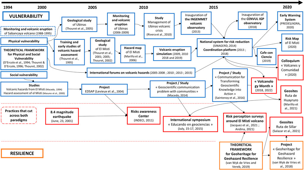
FIGURE 3. Genealogical map of the practices between vulnerability and resilience in Arequipa (1994—2020).
Indeed, it is through the studies of Jean-Claude Thouret (considered as a “Theoretical framework for Physical and Social Vulnerability” in Arequipa2, see Table 2), that can be seen to be the starting point of the whole volcanic risk management apparatus in Arequipa (including both the physical and social component of vulnerability). This apparatus shows a great variety of elements: geological studies of El Misti, projects like new early warning systems, tools like the map of hazards and risks, places like the volcanic observatory of the INGEMMET and events like the simulations of volcanic eruption or the “Cafe con Ciencia.” It should be noted that a natural event like the eruption of the Ubinas volcano plays a role in the apparatus. Among the actors who participate in this apparatus, we can distinguish official institutions in charge of volcano monitoring, volcanology research laboratories, organizations in charge of the risk management plan but also mayors, the Andean museum, the Alliance Française, and also NGOs. All of these elements gradually transform a theoretical framework into an operational apparatus. We can note in this regard that this operational apparatus was co-constructed between risk management practitioners, volcanological engineers and scientists in a spontaneous way while there was only a weak institutional structuring around risk management in Arequipa and few means to develop it. Indeed, it is only since 2014 with the establishment of SINAGERD that Peru has had a risk management policy articulated between the local and national levels. Thus, local risk management practices have significantly increased interest, funding, and knowledge dissemination in the city of Arequipa, as well as the institutional structuring of risk management with a specific program.
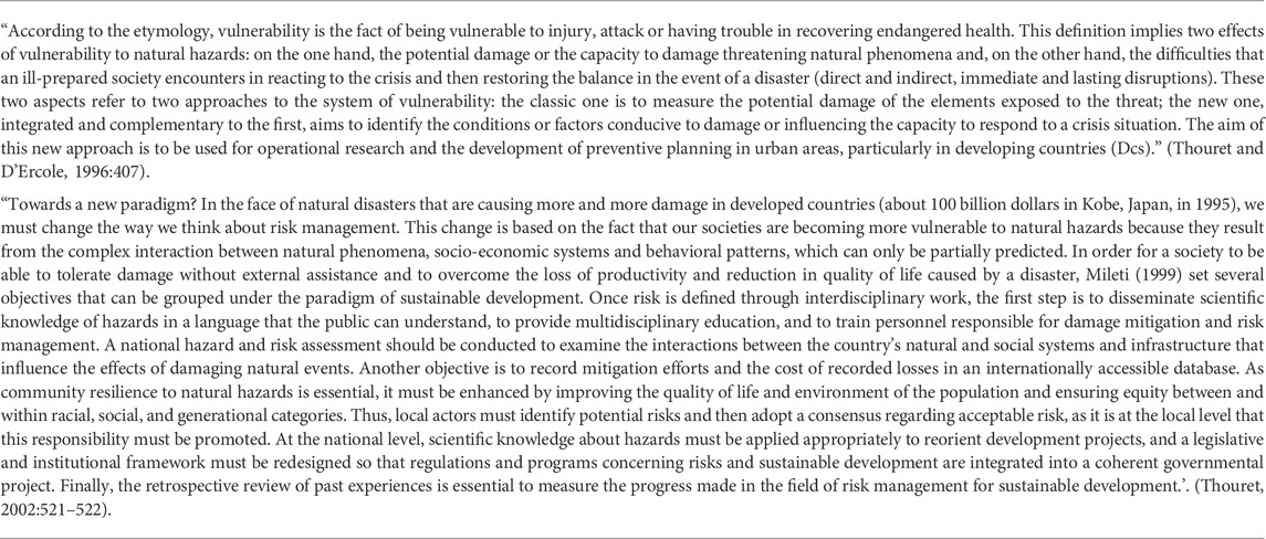
TABLE 2. Theoretical framework for Physical and Social Vulnerability’ in Arequipa.
The resilience-centered volcanic risk management apparatus in Arequipa developed in the Geoheritage for Geohazard Resilience project also starts with a “Theoretical framework for Geoheritage for Geohazard Resilience” in Arequipa (see Table 3).
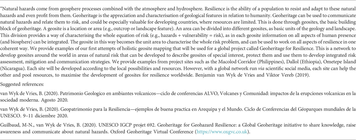
TABLE 3. Theoretical framework for Geoheritage for Geohazard Resilience in Arequipa.
Van Wyk de Vries investigates approaches based on the social vulnerability paradigm but introduce resilience operations through geosites design. Indeed, the geosites are not only tools with a defensive vocation: they emerge thanks to the co-construction with stakeholders initially not concerned by risk management but affected by risk (the miners of the Sillar quarry), they have the vocation to respond to the tourist demand while respecting the geological heritage, and above all, they are educational and sensitive apparatuses that include artistic approaches (realization of frescoes by the miners) as much as sensorial landscape places.
Practices are less numerous for the “Theoretical framework fo Geoheritage for Resilience” because of the recent history of the apparatus, which started just in the last few years. On the other hand, this apparatus will play a specific role depending on the places chosen for the geosites. The same stakeholders are involved in this apparatus as in the vulnerability apparatus, which proves the interest of this approach but also its complementarity in relation to the vulnerability one, in which they are all involved. In Arequipa, there is an articulation between the two paradigms that can be described as a paradigm of physical and social vulnerability, with social vulnerability being mitigated by resilience operations such as the geosites and the risks awareness center, because the choice of locations is partly based on the well used equation: Risk = Hazard + Vulnerability.
We question the articulation between the vulnerability and resilience paradigms in Arequipa through practices which are not all linked to a single Theoretical framework but both of them. Indeed, risk perception is the end point of the “Theoretical framework for Physical and Social Vulnerability” (Thouret, 2002): “As community resilience to natural hazards is essential, it must be enhanced by improving the quality of life and environment of the population and ensuring equity between and within racial, social, and generational categories.” Thus, local actors must identify potential risks and then adopt a consensus regarding acceptable risk, as it is at the local level that this responsibility must be promoted. Risk perception is also the starting point of the “Theoretical framework for Geoheritage for Geohazard Resilience,” which implies the presence of four border objects, straddling the two paradigms that establish connections between them. These are:
- The project of the Ruta de Huayruro carried by the stakeholders of the “Theoretical framework for Physical and Social Vulnerability,” and influenced by the contributions of the Geoheritage section at INGEMMET. We justify their place here in the transition they make towards the consideration of factors related to awareness and education: “these resources can help promote awareness of geological risks through dissemination and education, which aims at mitigating the risk of disasters” (Mariño et al., 2021);
- A link can also be made between the studies conducted on geoscientific communication around the “Theoretical framework for Physical and Social Vulnerability” that lead to the design of Ruta de Huayruro (Macedo et al., 2014; Saintenoy et al., 2016) and the current projects on risk perception around El Misti that approach the designs of the “Theoretical framework for Geoheritage for Geohazard Resilience” (Jacquez et al., 2019; Andina, 2021);
- The Risks Awareness Center, whose initiative emerges due to an expert in the field and whose objective is to enable the dissemination of knowledge on risks. This approach was initiated and made possible due to the personal initiative of General Carlos Nacarino, who succeeded in surrounding his idea with entrepreneurs from the region to finance it. This center is at first a pedagogical tool that fits into the paradigm of social vulnerability, but the individual initiative of the general coupled with the participation of citizens and institutions involved in risk management, has allowed a bottom-up co-construction that we consider as a resilient approach. However, local communities that experience the risks were not involved (except for financial support), but only invited to come and experience it once it was constructed. This is why we will place it at the junction between the two paradigms;
- The “Volcanes y Comunidad” colloquium, brought together stakeholders from both theoretical frameworks around presentations oriented to vulnerability and risk perception in a resilient approach.
We propose a complete representation of both risk management apparatuses that have been built up over 30 years around the two main theoretical frameworks related to an apparatus, with the representation of these border objects that reflect the porous boundaries between the two paradigms (see Figure 3). The question of genealogy is always in the background with Michel Foucault’s work, as he pays particular attention to the history of apparatuses, and to the way in which the links are constituted throughout history (Foucault, 2009). That is why we suggested a genealogical representation that documents the emergence of different practices over 30 years, and highlight their place in the vulnerability and resilience paradigms.
Regarding the articulation between the two paradigms of volcanic risk management in Arequipa, the vulnerability paradigm structures the whole, it appears in both the physical and social aspects. The proposition around the Theoretical framework for Geoheritage for Geohazard Resilience can be described as a place-based resilience operation from a classical vulnerability approach, as another way of understanding social vulnerability.
We could also integrate other elements of the apparatus, such as the doctrines of institutions, and the logics of power between actors in further work as proposed by Donovan (2017). We are aware that such a conceptualization implies rather top-down structural logics of knowledge transfer between North and South (Bankoff, 2004; Gaillard et al., 2010). However, the theoretical framework could be the creation of local stakeholders that will organize themselves around a singular idea to defend, which could be the first link towards the realization of community activities based on its own decisions to build a common meaning. With our proposal, we show that we can design a risk management apparatus thought to include participatory approaches with citizens of the civil society (Cadag et al., 2018). Indeed, a study suggests energising this stream around livelihoods through the practice approach (Sakdapolrak, 2014). We point out that the field of livelihoods is absent from studies on El Misti volcano, while it is considered a fundamental factor in both paradigms, in other volcanic areas, including nearby ones such as Ecuador (Kelman and Mather, 2008; Barclay et al., 2019).
Finally, the last point to be addressed is the role played by studies on the differentiated perception of risk by the inhabitants in the management of volcanic risks. It is interesting to note that several surveys are undertaken in both the vulnerability and resilience apparatuses. But what to do with the results of this type of investigation? In the vulnerability paradigm, it can be used as an indicator of the difficulty of building a consensus around the perception of risk. In the resilience paradigm, it can be used as the first step in a new approach to risk management, which would consist of mapping the worlds of sensitivity in volcanic risk management and using this mapping to co-construct an apparatus (Lièvre et al., 2021). The challenge is to build an apparatus along the way that avoids the collapse of meaning for this wide variety of actors. The construction of meaning (sensemaking) is the prerequisite for actors to behave in an extreme event, a volcanic eruption (Lièvre et al., 2019). In this perspective, the set of operations linked to the vulnerability paradigm could be considered as a part of the anticipatory capacity of a resilience approach (Hollnagel et al., 2006).
We participate in the extremely rich, fertile, but complex debates between vulnerability and resilience within geography and Earth sciences by proposing to approach them from the paradigm perspective in Kuhn’s sense. As we have shown, this is a plausible interpretation we can make of these debates (Dauphiné and Provitolo, 2007; Cutter, 2018). We are moving historically from the vulnerability paradigm to the resilience paradigm in risk management. The transition from one paradigm to another is always a radical change of viewpoint that can better integrate a number of questions posed by the previous paradigm. Thus, we have suggested distinguishing the two paradigms in a radical way by pairs of contrasts, in order to better situate the oppositions but also the links that can be established between these two ways of understanding risk management.
We have shown the relevance of mobilizing this paradigm grid of vulnerability and resilience to account for the evolution of volcanic risk management practices in Arequipa from the 1990s to the present. The vulnerability paradigm implies developing defensive activities around the eruptive potential of El Misti. For example, new early warning systems, a national risk management system, studies of the probability of being affected by the risks based on calculations... Shortly, practices that aim to calculate, control and minimize the risk. Despite the work carried out in Arequipa, this approach teaches us that it is difficult for the population to imagine the risks caused by a potential eruption, having never had the experience of this type of event. There is an awareness at the local level that disaster prevention also depends on the resilience of society, that is, the local capacity to cope with disasters of volcanic origin. A factor that tends to be minimized in the technology-based vulnerability paradigm. This implies thinking about other, more offensive strategies that we consider under the umbrella of the resilience paradigm.
From 2015, a secondary theoretical framework appears around geoheritage and resilience. We suggest to refer to Table 1 to understand the place of this theoretical framework between vulnerability and resilience. First, it is centered on risk rather than on uncertainty, as something we do not know in advance, but it tends towards the resilience paradigm by taking the territory and the capacity to adapt as a basic principle. Secondly, it emphasizes the involvement of the human factor, which is the starting point of the solution to a problem in the resilience paradigm. Geosites are a more grounded approach around risk knowledge, as they are “units” that holistically bring together what was previously generally separated. The geosite is a site where risk can be experienced, it is not only cognitively apprehended out of context but corporeally. It thus implies this pedagogical dimension in situation, bringing a pedagogical value to the apparatus. Finally, the geosite is also an essential place to live for certain workers (the miners). The geosite brings an essential “ecological and corporal anchoring” on the risks that are contextualized instead of being only “perceived” by surveys on risk perception whose results do not seem to show a particular evolution in Arequipa.
Nevertheless, the starting point of geosites in this case is places deliberately identified as particularly vulnerable (natural and societal). Therefore, we consider the geosite as a resilient operation but with a theoretical framework at the junction between the vulnerability and resilience paradigms. Practically, this geoheritage work has had the effect of assisting the local people in stabilizing their livelihoods and social situation, and with improved economy and standing assisted them to defend their interests, and take a lead in their own disaster risk reduction practices from their own point of view backed up by the scientific community. There are links between practices around vulnerability and resilience but some of them are independent, separate and autonomous as the risks awareness center, a spontaneous resilience operation that does not refer to a theoretical framework. It is a highly practical personal response.
We narrated 30 years of the history of volcanic risk management in Arequipa and used the notion of “apparatus” as a methodological tool in the sense of Foucault (2001); Foucault (2009) to highlight and order the different practices. As we mentioned, by entering the apparatus understood as a set of heterogeneous elements linked together in order to produce an activity, we find links with assemblage theories (Donovan, 2017; McGowran and Donovan, 2021) based on Latour’s work (2006). We analyze this apparatus, not directly through the actors, but through the manifestation of what they do: they produce theoretical frameworks; make studies, maps, simulations; organize symposiums and workshops; set up projects and build up institutions. It includes many elements, of different forms: theoretical frameworks, geological studies, hazard map, risk map, simulation, symposiums, forums, surveys on risk perception, café con ciencia and geotourism.
The apparatus makes it possible to identify both the local anchoring of these activities (geosites, simulations, etc.) and the ideal or theoretical elements that are sometimes external to the local context and yet play a decisive role in the development of the apparatus. We produced a genealogical map (Figure 3) of the apparatus that provides a historical account of the evolution of risk management practices in Arequipa. We then highlighted the specificity of the theoretical framework that allows to order and energize all the elements of the apparatus, in an assemblage, relative to the context of Arequipa in Southern Peru. We found that the “paradigm” in the sense of Kuhn (1972) could be associated with vulnerability and resilience to document volcanic risk management. The apparatus is the arrangement that makes it possible to account for the effective links between the theoretical framework, itself anchored in a paradigm, and the development of activities by risk management actors (see Figure 4 below). We must precise that the links highlighted pre-exist the researcher’s analysis and constitute the “performance” of the collective action (Gilbert and Raulet-Croset, 2021) thanks to the activities carried out over a long period of time.
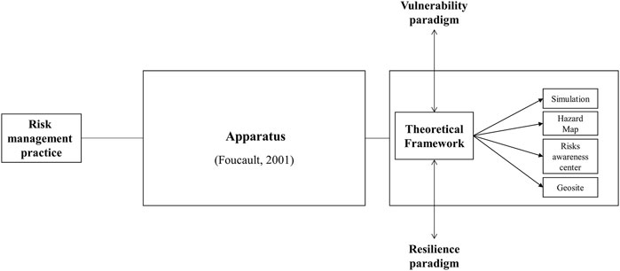
FIGURE 4. Framework for risk management practice between vulnerability and resilience.
This proximity shows that we can better link together the scattered activities carried out by the actors that are sometimes difficult to organize around a common thread. The apparatus organizes all the activities and allows to bring out in a concrete and orderly way what has already been realized under the aegis of a theoretical framework, in a non-linear way and not always conscious by the actors. Furthermore, it is possible to mobilize this theoretical framework in a general way beyond the single case of Arequipa, to document volcanic risk management practices elsewhere in the world between vulnerability and resilience as recommended by recent studies (Miller et al., 2010; Fekete et al., 2014).
We showed the strength of the theoretical framework and the academic works to enroll people and develop activities around an idea. Nevertheless, these studies are mostly conducted by foreign Western scientists, which is a limit from the point of view of the self-determination of local actors in the production of ideas. The major problem is structural, Peru does not have university structures as important as in the West in the field of volcanology, which implies an important transfer of knowledge from North to South (Gaillard et al., 2010). However, scientists have also promoted the learning of Peruvian actors by allowing them to study in France in master’s degree programs, which has considerably increased local know-how, skills and development of observatories in volcanology. Thus, along the way, the initiative initially carried by the “North” slides towards the assumption of responsibility by the “South” for its own practices and ideas to develop. The independent civil defense center (risks awareness center) was an early form of this, and the geoheritage program, based on prior community consultation and working with communities. In this latter, the external actors (international researchers) take a secondary role in an activity fully integrated with the locals. The “international experts” are integrated into this apparatus as members, financiers, advisors but are no longer “top dogs,” but rather one of the pack.
The political and institutional implications of these analyses suggest that we need to invent new ways of organizing ourselves in the face of a potential volcanic eruption, in addition to those developed in the vulnerability paradigm. In this case, it would be necessary to develop proactive strategies located as close as possible to the population. Each district of Arequipa has a district mayor around whom “juntas” (councils) are organized to deal with issues involving the members of these communities. These are opportunities to develop livelihoods (Kelman and Mather, 2008; Barclay et al., 2019) at the intersection of scholarship and practices that include knowledge, politics, scales and different dynamics at the scale of a territory (Scoones, 2009). There are therefore opportunities for finer articulation between the different scales of a territory, and this by encouraging new practices closer to the actors, those who live the risks, and not only in a representational dimension of risk.
We can identify limitations of this research as areas for research development. The different elements highlighted thanks to the apparatus as a methodological tool should be better qualified generically, the links that have been established between them should be better identified and the coherence of the whole should be discussed. It would be also necessary to carry out an exhaustive study of the existence of genealogical maps documenting volcanic risk management practices. We suggest extending the notion apparatus in future research in greater depth in relation to the management literature (McKinlay and Starkey, 1998; Gilbert and Raulet-Croset, 2021) as a powerful way to document the way people organize themselves. In addition, this theoretical framework fits with the perspective adopted in the Disaster Risk Management Assemblage (DRMA) (Donovan and Oppenheimer, 2014; Donovan, 2017, 2019, 2021; McGowran and Donovan, 2021). The work of Gaillard offers insights to improve risk management (Gaillard, 2010; Gaillard et al., 2010; Gaillard and Mercer, 2013; Gaillard, 2022).
We could also link this work with the theoretical framework of epistemic communities (Amin and Cohendet, 2004). Indeed, we can understand the path of each apparatus initiated by a researcher who has enlisted a certain number of partners to transform the theoretical framework into an operational apparatus - a code-book - by mobilizing the theory of epistemic communities. The literature on the notion of epistemic community in the field of political, economic and management sciences (Haas, 1992; Cowan et al., 2000; Amin and Cohendet, 2004) proposes to document the conditions that will allow a theoretical manifesto to be incorporated into the field of practice. An epistemic community is a learning community where meaning is negotiated between heterogeneous actors. Cohendet et al. (2017) propose a grid, in his middleground theory, where the elements of a management apparatus on a territory must articulate fundamentally: manifesto, project, place and event. The broad categories proposed by Cohendet are found in both apparatuses, which establish the existence of a potential learning community. The interactions between the actors in relation to their variety in each apparatus should be better documented. It can be pointed out that maps and plans play an important role in the vulnerability apparatus and similarly that places play a particular role in the resilience apparatus. One could say that there is an event deficit in the resilience apparatus: a scheduled event that would have some recurrence.
The raw data supporting the conclusion of this article will be made available by the authors, without undue reservation.
Consent was obtained from the individual(s) for the publication of any potentially identifable images or data included in this article.
PL made the major contribution in this article by proposing the idea and writing the theoretical demonstration on paradigm, vulnerability, resilience and apparatus. EM conducted a literature review to accompany the theoretical demonstration. She also conducted the field survey, wrote the resulting narrative, and produced the concept map. JM and BWV brought their expertise in the fields of geography and Earth sciences to help us initiate this interdisciplinary discussion. Their theoretical contributions and reviews have been decisive in improving this work. LM, DR, MR, and PM provided important factual elements to write a narrative that is as close as possible to the practices carried out over the last 30 years in Arequipa. They also reviewed the proposed narrative.
The authors acknowledge the support received from the Agence Nationale de la Recherche of the French government through the program Investissements d’Avenir (16-IDEX-0001 CAP 20-25), especially the CIR, Centre International de Recherche of Université Clermont Auvergne. The Clermont Research Management (Clermont Recherche Management, EA3849) laboratory of Université Clermont Auvergne provided financial support for the publication of this article. Julie Morin received funding from the IMAGINE ERC Grant No 804162 to support the development of this paper. The Geoheritage for Geohazard Resilience project 692 of the UNESCO International Geosciences Programme funded workshops and forms a basis for discussion and dynamic progress (www.geopoderes.com).
We thank the reviewers whose comments helped us to improve the idea and the structure of this paper. We warmly thank Jean-Claude Thouret for his enganement to answer our questions. His valuable contributions have allowed us to draw up with precision this narrative around the practices and initiatives carried out for nearly 30 years in Arequipa. We would like to thank all the institutions that opened their doors to us for this research: Laboratoire Magma et Volcans (LMV, Clermont-Ferrand, France), Instituto Geofísico del Perú (IGP, Arequipa), Instituto Geológico, Minero y Metalúrgico (OVI-INGEMMET, Arequipa), Instituto Nacional de Defensa Civil (INDECI, Arequipa), Centro de Operaciones de Emergencia Regional (COER, Arequipa) and Subegerencia a los riesgos de la municipalidad de Arequipa.
The authors declare that the research was conducted in the absence of any commercial or financial relationships that could be construed as a potential conflict of interest.
All claims expressed in this article are solely those of the authors and do not necessarily represent those of their affiliated organizations, or those of the publisher, the editors and the reviewers. Any product that may be evaluated in this article, or claim that may be made by its manufacturer, is not guaranteed or endorsed by the publisher.
1Translation from spanish: “Centro de sensibilización de riesgo de desastres”.
2Text in Tables 2, 3 were translated from french.
Adger, W. N. (2006). Vulnerability. Glob. Environ. Change 16, 268–281. doi:10.1016/j.gloenvcha.2006.02.006
Alexander, D. E. (2013). Resilience and disaster risk reduction: An etymological journey. Nat. Hazards Earth Syst. Sci. 13, 2707–2716. doi:10.5194/nhess-13-2707-2013
Amin, A., and Cohendet, P. (2004). Architectures of knowledge: Firms, capabilities, and communities. New York, NY, USA: Oxford University Press.
Andina, I. G. P. (2021). Arequipeños tienen baja percepción del peligro volcánico del Misti. Noticias, Agencia Peruana de Noticias Andina. Available at: https://andina.pe/agencia/noticia-igp-arequipenos-tienen-baja-percepcion-del-peligro-volcanico-del-misti-857612.aspx (Accessed August 8, 2022).
Angell, E. (2014). Assembling disaster: Earthquakes and urban politics in Istanbul. City 18, 667–678. doi:10.1080/13604813.2014.962881
Bankoff, G. (2004). Time is of the essence: Disasters, vulnerability and history. Int. J. Mass Emergencies Disasters 22, 23–42.
Barclay, J., Few, R., Armijos, M. T., Phillips, J. C., Pyle, D. M., Hicks, A., et al. (2019). Livelihoods, wellbeing and the risk to life during volcanic eruptions. Front. Earth Sci. (Lausanne). 7, 15. doi:10.3389/feart.2019.00205
Barroca, B., DiNardo, M., and Mboumoua, I. (2013). De la vulnérabilité à la résilience: Mutation ou bouleversement? EchoGéo 24.
Bourdieu, P. (1972). “Esquisse d’une théorie de la pratique,” in Esquisse d’une théorie de la pratique Travaux de Sciences Sociales (Genève: Librairie Droz), 157–243. Available at: https://www.cairn.info/esquisse-d-une-theorie-de-la-pratique--9782600041553-p-157.htm (Accessed August 19, 2022).
Brocx, M., and Semeniuk, V. (2007). Geoheritage and geoconservation – history, definition, scope and scale. J. R. Soc. West. Aust. 35.
Cadag, J. R., Driedger, C., Garcia, C., Duncan, M., Gaillard, J. C., Lindsay, J., et al. (2018). “Fostering participation of local actors in volcanic disaster risk reduction,” in Observing the volcano world: Volcano crisis communication advances in volcanology. Editors C. J. Fearnley, D. K. Bird, K. Haynes, W. J. McGuire, and G. Jolly (Cham: Springer International Publishing), 481–497. doi:10.1007/11157_2016_39
Callon, M., Lascoumes, P., and Barthe, Y. (2009). Acting in an uncertain world: An essay on technical democracy (Inside technology). London: The MIT press.
Cobeñas, G., Thouret, J.-C., Bonadonna, C., and Boivin, P. (2012). The c.2030yr BP Plinian eruption of El Misti volcano, Peru: Eruption dynamics and hazard implications. J. Volcanol. Geotherm. Res. 241–242, 105–120. doi:10.1016/j.jvolgeores.2012.06.006
Cohendet, P., Parmentier, G., and Simon, L. (2017). “Managing knowledge, creativity and innovation,” in The Elgar companion to innovation and knowledge creation (Cheltenham, UK ; Northampton, MA: Edward Elgar Publishing).
Cowan, R., David, P. A., and Foray, D. (2000). The explicit economics of knowledge codification and tacitness. Industrial Corp. change 9, 211–253. doi:10.1093/icc/9.2.211
Cutter, S. L., Barnes, L., Berry, M., Burton, C., Evans, E., Tate, E., et al. (2008). A place-based model for understanding community resilience to natural disasters. Glob. Environ. Change 18, 598–606. doi:10.1016/j.gloenvcha.2008.07.013
Cutter, S. L. (2018). “Linkages between vulnerability and resilience,” in Vulnerability and resilience to natural hazards. Editors S. Fuchs, and T. Thaler (Cambridge: Cambridge University Press), 257–270.
Cutter, S. L. (1996). Societal responses to environmental hazards. Int. Soc. Sci. J. 48, 525–536. doi:10.1111/1468-2451.00053
Cutter, S. L. (2006). “The science of vulnerability and the vulnerability of science,” in Hazards Vulnerability and Environmental Justice (Routledge), 161–178.
Dauphiné, A., and Provitolo, D. (2007). Risques et catastrophes: Observer, spatialiser, comprendre, gérer. Paris: Armand Colin, 115–125.
Dauphiné, A. (2001). Risques et catastrophes: Observer, spatialiser, comprendre, gérer, paris, A. Colin, 288 p. Davy L.(1990), « La catastrophe de Nîmes (1988) était-elle prévisible? Bull. de Société Languedocienne de Géogr. nspécial «Catastrophes risques naturels, 133–162.
Degg, M. R., and Chester, D. K. (2005). Seismic and volcanic hazards in Peru: Changing attitudes to disaster mitigation. Geogr. J. 171, 125–145. doi:10.1111/j.1475-4959.2005.00155.x
D’Ercole, R., Thouret, J.-C., Dollfus, O., and Asté, J.-P. (1994). Les vulnérabilités des sociétés et des espaces urbanisés : Concepts, typologie, modes d’analyse. rga. 82, 87–96. doi:10.3406/rga.1994.3776
Donovan, A. (2021). Colonising geology: Volcanic politics and geopower. Polit. Geogr. 86, 102347. doi:10.1016/j.polgeo.2021.102347
Donovan, A. (2019). Critical volcanology? Thinking holistically about risk and uncertainty. Bull. Volcanol. 81, 20. doi:10.1007/s00445-019-1279-8
Donovan, A. (2017). Geopower: Reflections on the critical geography of disasters. Prog. Hum. Geogr. 41, 44–67. doi:10.1177/0309132515627020
Donovan, A., and Oppenheimer, C. (2014). Science, policy and place in volcanic disasters: Insights from Montserrat. Environ. Sci. Policy 39, 150–161. doi:10.1016/j.envsci.2013.08.009
Dupuy, J.-P., and Grinbaum, A. (2005). Living with uncertainty: From the precautionary principle to the methodology of ongoing normative assessment. Comptes Rendus Geosci. 337, 457–474. doi:10.1016/j.crte.2005.01.004
Fekete, A., Hufschmidt, G., and Kruse, S. (2014). Benefits and challenges of resilience and vulnerability for disaster risk management. Int. J. Disaster Risk Sci. 5, 3–20. doi:10.1007/s13753-014-0008-3
Fenton, C., and Langley, A. (2011). Strategy as practice and the narrative turn. Organ. Stud. 32, 1171–1196. doi:10.1177/0170840611410838
Fischhoff, B., Kadvany, J., and Kadvany, J. D. (2011). Risk: A very short introduction. New York, NY, USA: Oxford University Press.
Folke, C. (2006). Resilience: The emergence of a perspective for social–ecological systems analyses. Glob. Environ. Change 16, 253–267. doi:10.1016/j.gloenvcha.2006.04.002
Foucault, M. (2009). in Security, territory, population: Lectures at the collège de France 1977-78. Editor M. Senellart Basingstoke (Basingstoke: Palgrave Macmillan).
S. Fuchs, and T. Thaler (Editors) (2018). Vulnerability and resilience to natural hazards (Cambridge; New York: Cambridge University Press).
Gaillard, J.-C. (2010). Vulnerability, capacity and resilience: Perspectives for climate and development policy. J. Int. Dev. 22, 218–232. doi:10.1002/jid.1675
Gaillard, J.-C., Wisner, B., Benouar, D., Cannon, T., Creton-Cazanave, L., Dekens, J., et al. (2010). Alternatives for sustained disaster risk reduction. Hum. Geogr. 3, 66–88. doi:10.1177/194277861000300106
Gaillard, J. C., and Mercer, J. (2013). From knowledge to action: Bridging gaps in disaster risk reduction. Prog. Hum. Geogr. 37, 93–114. doi:10.1177/0309132512446717
Gaillard, J. (2022). The epistemological non-sense of disaster studies and some more sensible prospects. TheAustralian J. Emerg. Manag. 37, 14–15.
Gallopín, G. C. (2006). Linkages between vulnerability, resilience, and adaptive capacity. Glob. Environ. Change 16, 293–303. doi:10.1016/j.gloenvcha.2006.02.004
Giddens, A. (1979). Central problems in social theory: Action, structure, and contradiction in social analysis. Berkeley; Los Angeles: University of California Press.
Gilbert, P., and Raulet-Croset, N. (2021). Lire le management autrement: Le jeu des dispositifs. Caen: Éditions EMS.
Gillard, R., Gouldson, A., Paavola, J., and Van Alstine, J. (2016). Transformational responses to climate change: Beyond a systems perspective of social change in mitigation and adaptation. WIREs Clim. Change 7, 251–265. doi:10.1002/wcc.384
Glaser, B. G., and Strauss, A. L. (2017). Discovery of grounded theory: Strategies for qualitative research. New York, NY, USA: Routledge.
Golsorkhi, D., Rouleau, L., Seidl, D., and Vaara, E. (2010). Cambridge handbook of strategy as practice. Cambridge; New York, NY, USA: Cambridge University Press.
Gonzalez-Ferran, O. (1990). “Huayna Putina volcano: The biggest historical dacitic eruption in the Central Andes of South America,” in Intern. Volcanol. Congress, IAVCEI, Mainz, FRG.
Gray, J. M. (2004). Geodiversity: Valuing and conserving abiotic nature. Chichester, West Sussex ; Hoboken, NJ: J. Wiley.
Grove, K., and Adey, P. (2015). Security and the politics of resilience: An aesthetic response. Politics 35, 78–84. doi:10.1111/1467-9256.12078
Grove, K. (2013). Hidden transcripts of resilience: Power and politics in Jamaican disaster management. Resilience 1, 193–209. doi:10.1080/21693293.2013.825463
Guilbaud, M., van Wyk de Vries, B., Nemeth, K., Vereb, V., Hagos, M., Manrique, N., et al. (2020). “Geoheritage for geohazard resilience: A global initiative to share knowledge, raise awareness and communicate about natural hazards,” in Oxford Geoheritage Virtual Conference (Oxford: Springer), 67–68.
Haas, P. M. (1992). Introduction: Epistemic communities and international policy coordination. Int. Organ. 46, 1–35. doi:10.1017/s0020818300001442
Hoempler, A. (1962). Valle de volcanes de Andahua, Arequipa. Segundo Congr. Nac. Geol. Soc. Geol. del Perú, Lima 37, 59–69.
E. Hollnagel, D. D. Woods, and N. Leveson (Editors) (2006). Resilience engineering: Concepts and precepts (Aldershot, England, Burlington, VT: Ashgate).
Huaman-Rodrigo, D., Chorowicz, J., Deffontaines, B., Guillande, R., and Rudant, J.-P. (1993). Cadre structural et risques géologiques étudiés à l’aide de l’imagerie spatiale; la region du Colca (Andes du sud Perou). Bull. Société Géologique Fr. 164, 807–818.
INEI (2018). “Arequipa alberga a 1 millon 316 mil habitantes. Nota de prensa,” in Instituto Nacional de Estadistica e Informatica, 181. Available at: https://m.inei.gob.pe/media/MenuRecursivo/noticias/nota-de-prensa-n181-2017-inei_1.pdf (Accessed May 16, 2022)
Jacquez, L., and Rouquette, S. (2021). “Le risque volcanique au Pérou : Perception des habitants et campagne de communication,” in Séminaire interdisciplinaire et pluriannuel "Sciences, société, communication, Grenoble, 8 novembre 2021 (Maison des Sciences de l’Homme Alpes). Available at: https://www.msh-alpes.fr/actualites/perception-risque-volcanique-arequipa-perou-enquete-croisee-aupres-habitants-et-communicants (Accessed May 6, 2022).
Jarzabkowski, P. (2003). Strategic practices: An activity theory perspective on continuity and change. J. Manag. Stud. 40, 23–55. doi:10.1111/1467-6486.t01-1-00003
Juvigné, É., Thouret, J.-C., Gilot, É., Gourgaud, A., Graf, K., Leclercq, L., et al. (1997). Étude téphrostratigraphique et bio-climatique du Tardiglaciaire et de l’Holocène de la Laguna Salinas, Pérou meridional. gpq. 51, 221–233. doi:10.7202/033120ar
Kelman, I., Lewis, J., Gaillard, J., and Mercer, J. (2015). Island contributions to disaster research. Glb. Environ. 8, 16–37. doi:10.3197/ge.2015.080102
Kelman, I., and Mather, T. A. (2008). Living with volcanoes: The sustainable livelihoods approach for volcano-related opportunities. J. Volcanol. Geotherm. Res. 172, 189–198. doi:10.1016/j.jvolgeores.2007.12.007
Knight, F. H. (1921). Risk, uncertainty and profit. Boston: Houghton Mifflin Company, The Riverside Press.
Le Moigne, J.-L. (1977). La théorie du système général. Théorie de la modélisation. Paris: Presses Universitaires de France.
Levieux, G., Arnaud, J., Avard, G., Benbakkar, M., Bennati, L., Chávez, J. A., et al. (2007). Contribution to volcanic risk mitigation in Southern Peru through an original approach of public education and awareness. Perugia, Italie: IUGG, 2–13.
P. Lièvre, M. Aubry, and G. Garel (Editors) (2019). Management of extreme situations (Hoboken: ISTE Ltd/John Wiley and Sons Inc).
Lièvre, P., Mérour, E., Récopé, M., Rix-Lièvre, G., van Wyk de Vries, B., and Boyer, S. (2021). “Les obstacles à la construction du sens en situation extrême : Le cas des éruptions volcaniques à arequipa au Pérou,” in Colloque International de Recherche 4 « Risques naturels et vulnérabilités socio-économiques », LMV, Campus des Cézeaux, Clermont-Ferrand, 25-26 novembre 2021 (Université Clermont Auvergne).
Macedo, L. (1994). Peligro volcánico potencial del Misti. Tesis de Ingeniero Geólogo. Arequipa: Universidad Nacional de San Agustín, 112.
Macedo, L., Villacorta, S., Vasquez, S., Mariño, J., and Di Capua, G. (2014). “Firms and the Welfare State: When, Why, and How Does Social Policy Matter to Employers?,” in Varieties of Capitalism. The Institutional Foundations of Comparative Advantage (London, United Kingdom: Oxford University Press), 184–213.
Mariño, J., Cueva, K., Thouret, J.-C., Arias, C., Finizola, A., Antoine, R., et al. (2021). Multidisciplinary study of the impacts of the 1600 CE Huaynaputina eruption and a project for geosites and geo-touristic attractions. Geoheritage 13, 64. doi:10.1007/s12371-021-00577-5
Mariño, J., Rivera, M., Thouret, J.-C., Cacya, L., Siebe, C., Tilling, R., et al. (2006). Evaluación de peligros volcánicos y elaboración del mapa de peligros del volcán misti (arequipa). Repositorio INGEMMET: Available at: https://repositorio.ingemmet.gob.pe/handle/20.500.12544/441.
Marks, D. (2019). Assembling the 2011 Thailand floods: Protecting farmers and inundating high-value industrial estates in a fragmented hydro-social territory. Polit. Geogr. 68, 66–76. doi:10.1016/j.polgeo.2018.10.002
Masuno Kosaka, R., Macedo Franco, L., and Urquizo Diaz, H. (2000). Estudio:“mapa de peligro potencial del volcán misti. Conv. unsa el Proy. pnud-Gobierno Peru 98, 018.
McGowran, P., and Donovan, A. (2021). Assemblage theory and disaster risk management. Prog. Hum. Geogr. 45, 1601–1624. doi:10.1177/03091325211003328
McKinlay, A., and Starkey, K. (1998). Foucault, management and organization theory: From panopticon to technologies of self. London: Sage.
Miller, F., Osbahr, H., Boyd, E., Thomalla, F., Bharwani, S., Ziervogel, G., et al. (2010). Resilience and vulnerability: Complementary or conflicting concepts? Ecol. Soc. 15, art11. doi:10.5751/ES-03378-150311
Olive-Garcia, C., and van Wyk de Vries, B. (2017). “Geological nominations at UNESCO World Heritage, an upstream struggle,” in 19th EGU General Assembly, EGU2017, Vienna, Austria, 23-28 April, 2017, 8032.
Patzak, M., and Eder, W. (1998). UNESCO Geopark”. A new programme-a new UNESCO label. Geol. Balc. 28, 33–36.
Provitolo, D. (2010). “La vulnérabilité résiliençaire: Un cadre d’analyse des systèmes face aux risques et catastrophes,” in UNESCO chair EPFL (Lausanne, Suisse: International Scientific Conference on Technologies for Development).
Rivera, M., Thouret, J.-C., Mariño, J., Berolatti, R., and Fuentes, J. (2010). Characteristics and management of the 2006–2008 volcanic crisis at the Ubinas volcano (Peru). J. Volcanol. Geotherm. Res. 198, 19–34. doi:10.1016/j.jvolgeores.2010.07.020
Rouleau, L. (2013). Strategy-as-practice research at a crossroads. M@n@gement 16, 574–592. doi:10.3917/mana.165.0574
Saintenoy, T., Finizola, A., Thouret, J. C., Macedo, L., Macedo, O., Antoine, R., et al. (2016). Archaeological insights of the social impact of the Huaynaputina explosion 1600 AD, southern Peru: A multiscale regional perspective. Cities on volcanoes 9. Puerto Varas, Chili: Abstract & poster, 20–25.
Sakdapolrak, P. (2014). Livelihoods as social practices – Re-energising livelihoods research with bourdieu’s theory of practice. Geogr. Helv. 69, 19–28. doi:10.5194/gh-69-19-2014
Salazar, C., Manrique, N., Aguilar, R., and van Wyk de Vries, B. (2021). Geosite assessment in arequipa city - Peru: UNESCO IGCP 692 project “geoheritage for geohazard resilience. EGU21-8355. doi:10.5194/egusphere-egu21-8355
Sandri, L., Thouret, J.-C., Constantinescu, R., Biass, S., and Tonini, R. (2014). Long-term multi-hazard assessment for El Misti volcano (Peru). Bull. Volcanol. 76, 771. doi:10.1007/s00445-013-0771-9
Schatzki, T. R., Knorr-Cetina, K., and Von Savigny, E. (2001). The practice turn in contemporary theory. London: Routledge.
Scoones, I. (2009). Livelihoods perspectives and rural development. J. peasant Stud. 36, 171–196. doi:10.1080/03066150902820503
Seidman, I. (2006). Interviewing as qualitative research: A guide for researchers in education and the social sciences. 3rd ed. New York: Teachers College Press.
SINAGERD (2014). Plan nacional de gestión del riesgo de desastres (PLANAGERD, 2014-2021). Lima: Cenepred. Available at: https://cenepred.gob.pe/web/wp-content/uploads/Guia_Manuales/PLANAGERD%202014-2021.pdf (Accessed August 18, 2022).
Tamboukou, M. (2008). A Foucauldian approach to narratives. Doing Narrat. Res., 103–120. doi:10.4135/9780857024992.d8
Thouret, J.-C. (2002). Aléas et risques volcaniques : Mieux comprendre pour prévoir et mieux gérer pour durer. geo. 111, 503–523. doi:10.3406/geo.2002.21622
Thouret, J.-C., and D’Ercole, R. (1996). Vulnérabilité aux risques naturels en milieu urbain: Effets, facteurs et réponses sociales. Cah. Des. Sci. Hum. 18.
Thouret, J.-C., Finizola, A., Fornari, M., Legeley-Padovani, A., Suni, J., and Frechen, M. (2001). Geology of el Misti Volcano near the city of arequipa, Peru. Geol. Soc. Am. Bull. 113, 1593–1610. doi:10.1130/0016-7606(2001)113<1593:GOEMVN>2.0.CO;2
Thouret, J.-C., Guillande, R., Huaman, D., Gourgaud, A., Salas, G., and Chorowicz, J. (1994). L’Activite actuelle du Nevado Sabancaya (sud Perou); reconnaissance geologique et satellitaire, evaluation et cartographie des menaces volcaniques. Bull. Société Géologique Fr. 165, 49–63.
Thouret, J.-C., Rivera, M., Wörner, G., Gerbe, M.-C., Finizola, A., Fornari, M., et al. (2005). Ubinas: The evolution of the historically most active volcano in southern Peru. Bull. Volcanol. 67, 557–589. doi:10.1007/s00445-004-0396-0
Thouret, J. C., Legros, F., Gourgaud, A., Salas, G., Juvigne, E., Gilot, E., et al. (1995). Recent eruptive activity at el-Misti Volcano (south Peru) - implications for hazard assessment in arequipa area. Comptes rendus l’Académie Sci. - Séries IIB - - Mécanique, Phys. Chim. Astron. 320, 923.
Tomassi, I. (2018). Magalie Reghezza-Zit et Samuel Rufat (dir), Résiliences. Société et territoires face à l’incertitude, aux risques et aux catastrophes. Géocarrefour 92. doi:10.4000/geocarrefour.11317
Turner, B. L. (2010). Vulnerability and resilience: Coalescing or paralleling approaches for sustainability science? Glob. Environ. Change 20, 570–576. doi:10.1016/j.gloenvcha.2010.07.003
Van Maanen, J. (2011). Tales of the field: On writing ethnography. 2nd ed. Chicago: University of Chicago Press.
van Wyk de Vries, B. (2013). “Geoheritage and Sense of Place of the Chaîne des Puys and Limagne Fault: How Peope Understand Geoscience Through Belonging to Their Landscape’,” in Geologic Society of America annual meeting.
van Wyk de Vries, B. (2020a). Patrimonio geologico en ambiantes volcanicos—ciclo de conferencias ALVO, Volcanes y Comunidad: Impactos de la erupciones volcanicas en la sociedad moderna. Arequipa: Agosto.
van Wyk de Vries, B. (2020b). “Geopatrimonio para la Resiliencia—Ejemplos de buena practica en arequipa y el Mundo,” in Ciclo de Conferencias del Géoparques mundiales de la UNESCO, Arequipa, 9–11 december 2020.
van Wyk de Vries, B., and Vereb, V. (2019). “Geoheritage for resilience: A global network for managing natural risk,” in EGU General Assembly Conference Abstracts, 8460.
White, G. F. (1974). Natural hazards, local, national, global. New York, NJ: Oxford University Press.
Whittington, R. (1996). Strategy as practice. Long. range Plan. 29, 731–735. doi:10.1016/0024-6301(96)00068-4
Keywords: vulnerability, resilience, paradigm, risk management practice, Arequipa
Citation: Lièvre P, Mérour E, Morin J, Macedo Franco L, Ramos Palomino D, Rivera Porras M, Masías Alvarez P and van Wyk de Vries B (2022) Volcanic risk management practice evolution between vulnerability and resilience: The case of Arequipa in Peru. Front. Earth Sci. 10:877161. doi: 10.3389/feart.2022.877161
Received: 16 February 2022; Accepted: 05 August 2022;
Published: 29 September 2022.
Edited by:
Rodrigo Cienfuegos, Pontificia Universidad Católica de Chile, ChileReviewed by:
Felipe Aguilera, Catholic University of the North, ChileCopyright © 2022 Lièvre, Mérour, Morin, Macedo Franco, Ramos Palomino, Rivera Porras, Masías Alvarez and van Wyk de Vries. This is an open-access article distributed under the terms of the Creative Commons Attribution License (CC BY). The use, distribution or reproduction in other forums is permitted, provided the original author(s) and the copyright owner(s) are credited and that the original publication in this journal is cited, in accordance with accepted academic practice. No use, distribution or reproduction is permitted which does not comply with these terms.
*Correspondence: Eléonore Mérour, ZWxlb25vcmUubWVyb3VyQHVjYS5mcg==
†These authors have contributed equally to this work and share first authorship
Disclaimer: All claims expressed in this article are solely those of the authors and do not necessarily represent those of their affiliated organizations, or those of the publisher, the editors and the reviewers. Any product that may be evaluated in this article or claim that may be made by its manufacturer is not guaranteed or endorsed by the publisher.
Research integrity at Frontiers
Learn more about the work of our research integrity team to safeguard the quality of each article we publish.