 Shuang Sun
 Yan Li
 Dawei Liu
 Ke Hu
Ke Hu
95% of researchers rate our articles as excellent or good
Learn more about the work of our research integrity team to safeguard the quality of each article we publish.
Find out more
ORIGINAL RESEARCH article
Front. Earth Sci. , 12 May 2022
Sec. Quaternary Science, Geomorphology and Paleoenvironment
Volume 10 - 2022 | https://doi.org/10.3389/feart.2022.865839
This article is part of the Research Topic Sedimentation on the Continental Margins: From Modern Processes to Deep-Time Records View all 28 articles
Provenance identification of the clastic sediments is critical for paleoenvironmental and morphological reconstruction on the estuarine coast. The North Bohai Coast (NBC) receives tremendous sediments mainly from the Liaohe and Daling fluvial systems. However, the detailed morphological evolution is still unclear due to the lack of precise discrimination of the sediment provenance. In this study, the clay mineralogy of the coastal sediments in the NBC was investigated to determine variation of the fine-grained sediment sources in the last century. The clay mineral content in the modern riverine sediments in the NBC was used to model sedimentary contribution from different fluvial systems. 210Pb and 137Cs radioactivity was measured to constrain the timing of centennial marine–terrestrial sedimentation. The migration of coastline and river channels in the NBC during the last hundred years was reconstructed by digitalizing the historical charts and satellite image. 210Pb following the CIC model and 137Cs dating are considered not applicable for the dated cores, whilst 210Pb using the CRS model yields acceptable chronologic results. Non-linear modeling results of the clay mineral composition are consistent with the lithological and coastal geomorphologic constraints. The outcome of provenance discrimination indicates that clay minerals in western and eastern NBC are mainly derived from the Daling and Liaohe rivers, respectively. In the middle NBC, the Daling River input was relatively major during the 1910s, 1940s, 1980s, and 2000s. The increase of Daling River input in the first two periods resulted from progradation and river channel migration, respectively. The fluvial contribution from the Liaohe River was major in the middle NBC during 1920–1940 and 1950–1970 AD, which attributes to rapid progradation of the Liaohe River and channel migration of the Daling River, respectively.
The estuarine coast is a critical area due to its ecological significance, environmental vulnerability, and socio-economic importance (IPCC, 2014). Paleoenvironment and morphology in the estuarine coast have changed significantly in different timescales due to the natural and anthropogenetic impacts. It is necessary to reconstruct the history of coastal environmental evolution to improve our understanding of regional response in the estuary to global change and for better protection of the estuarine coast.
River channel migration and sediment flux alternation are the two crucial controlling factors in shaping the estuarine morphology, which could be revealed by the provenance variation of the estuarine coastal sediments, especially for those controlled by multiple rivers. Physical, chemical, and mineralogical characteristics of the sediments have been used to trace sediment sources (e.g., Biscay, 1965; Jacobsen and Wasserburg, 1980; Chamley, 1989; Liu et al., 2003; Colin et al., 2006; Kissel et al., 2016; Gray et al., 2019). Among them, clay mineralogy is thought to be applicable in tracing the sediment provenance for the marine sediments, which has been widely used in the east margin of the Asian Continent (e.g., Hu et al., 2014; Cho et al., 2015; Liu et al., 2018; Cai et al., 2020). The previous studies have mainly focused on the provenance of multiple sediment sources in the marginal seas. Nevertheless, the estuarine coast has been rarely investigated, which largely limits us in reconstructing the history of coastal geomorphology evolution precisely and/or understanding the natural and anthropogenic control on the estuarine coasts over different timescales.
The northern coast of the Bohai Sea is one of the largest coastal estuaries in eastern China, with considerable sediments deriving from the Liaohe and Daling rivers (IOCAS, 1985). Owing to the paleoenvironmental and ecological significance, the sediments in the North Bohai Coast (NBC) and the adjacent area have been widely explored (e.g., Chen et al., 2010; Dou et al., 2014; He et al., 2018; Li J. et al., 2018; Li H. et al., 2019; Liu et al., 2019; Liu et al., 2020; Wang et al., 2020). Coastal geomorphology has significantly changed with frequent river channel migration and decreasing fluvial sediment flux in the NBC over the last century (Chen et al., 2010; Li Y. et al., 2018). Consequently, as one of the largest estuarine wetlands in eastern China, the NBC is facing the threats of wetland degradation and ecological destruction (Zhou et al., 2016). However, the influence of the Daling and Liaohe fluvial systems on the morphological change in the aspect of sedimentation supply is still unclear. The detailed morphological evolution caused by river channel migration has not been well investigated either. Since the sediments have recorded the information of provenance, it is meaningful to reconstruct the coastal morphology by discriminating the sediment provenance precisely in the NBC over the last century. It is also significant for a better understanding of the natural-anthropogenic influences on the coastal sedimentary processes.
The outcome of our previous investigation showed that the clay mineral assemblage in the modern Liaohe and Daling riverine sediments is illite and smectite dominated, respectively (Liu et al., 2019). This implies that clay mineralogy is potentially useful to trace the sources of sediments deposited in the NBC. Moreover, frequent river channel migration and continuous coastline retreats over the last century have been well documented in the historical archives. Therefore, the reliability of the discriminated provenance of the sediments in the NBC over the last century using clay mineralogy could be possibly assessed by the information on fluvial and coastline migration documented in the historical archives.
In this study, the shallow core sediments collected from the NBC were used for clay mineralogy, chronology, and stratigraphy studies. 210Pb and 137Cs activities for the sediments from four cores were measured to quantify the sedimentation rate. X-ray diffraction (XRD) analysis was carried out to determine the composition of the four main clay minerals, i.e. smectite, illite, kaolinite, and chlorite, for the sediments from ten representative cores. The historical maps were digitalized to extract information on the coastline and river channel migration in the last century. The main objectives of this study are as follows. First, we aim to construct a model to quantify the sediment contributions from the Liaohe and Daling rivers based on the clay mineralogy of modern riverine sediments (Liu et al., 2019). The reliability of the model was assessed by comparing the modeling result of the core sediments and the historical river channel migration. Our second aim is to reconstruct sediment transport and morphological evolution in the NBC over the last century combining the clay mineralogy and historical coastline-river channel migration.
The NBC is the marine-terrestrial interacted area in the Liaodong Bay, northern Bohai Sea (Figure 1). The NBC receives tremendous terrigenous sediments transported mainly by the Liaohe and Daling rivers. The mean tidal range in the NBC is 2.6 m. The annual mean temperature and precipitation in the study area are 8.9°C and 667.4 mm, respectively.

FIGURE 1. (A) Study area of the North Bohai Coast and bedrock types of the Liaohe and Daling rivers’ drainage basins. (B) Fluvial system, sampling sites of the sediment cores, and the modern fluvial sediments.
The Liaohe River is one of the largest rivers in China, originating from the southwest end of the Greater Khingan Mountains and the Changbai Mountain (Figure 1A). The drainage basin of the Liaohe River covers 2.20 × 10⁵ km2, including the local rivers, such as the Daliao and Raoyang rivers. The annual runoff of the Liaohe River is ca. 3.19 × 10⁹ m3. The main bedrock type in the upper Liaohe River Basin contains Mesozoic sedimentary rock and granite, Precambrian volcanic, and sedimentary rock. The middle-lower Liaohe River Basin is covered by the thick Quaternary sediments (Figure 1A. Liaoning Geology Bureau, 1983; IOCAS, 1985).
The Daling River originates from northern Yanshan Mountain. The area of the drainage basin is 2.32 × 10⁴ km2. With a sediment flux of 13.53 Mt/a and a mean suspended sediment concentration of 17.0 kg/m3, the Daling River is regarded as one of the muddiest rivers worldwide (Milliman and Syvitski, 1992). Bedrock types in the upper-middle Daling River Basin mainly include Mesozoic volcanic and sedimentary rocks, as well as Precambrian and Paleozoic volcanic rocks. The lower Daling River Basin is mainly covered by quaternary sediments (Figure 1A).
Due to Early-Middle Holocene sea-level rise, the lower Liaohe—Daling River Basin was submerged under seawater. The created accommodation space was infilled by terrigenous sediments afterward. In this study, the investigated area of the modern NBC was divided into the west, middle and east sub-zones by the Liaohe and Daling river channels (Figure 1B).
Nineteen cores were collected in the modern NBC using the portable power coring system in 2017. The lengths of the cores range from 274 to 400 cm. All the cores were photographed and lithologically described in the field. The cores are shown in five cross sections (AA′—DD′) in Figure 1 and Figure 2. The sediment cores can generally be vertically divided into two parts, including the lower dark-gray clayey silt and the upper brownish silty clay. The lower part contains mollusk shell fragments, whilst vegetation fragments were generally found in the upper part. A transitional layer of brownish-gray clayey silt with a length of 10–30 cm generally exists, which indicates that the environment gradually changed from intertidal flat to delta plain in the NBC. In total, 702 samples from ten cores were sampled and measured for clay mineralogical X-ray diffraction (XRD) analysis with an interval of 4 cm (red filled circles in Figure 1B). 210Pb and 137Cs dating were conducted using sediments with sampling interval of 10 cm from four representative cores LH34, LH40, LH49, and LH56 (Figure 3).
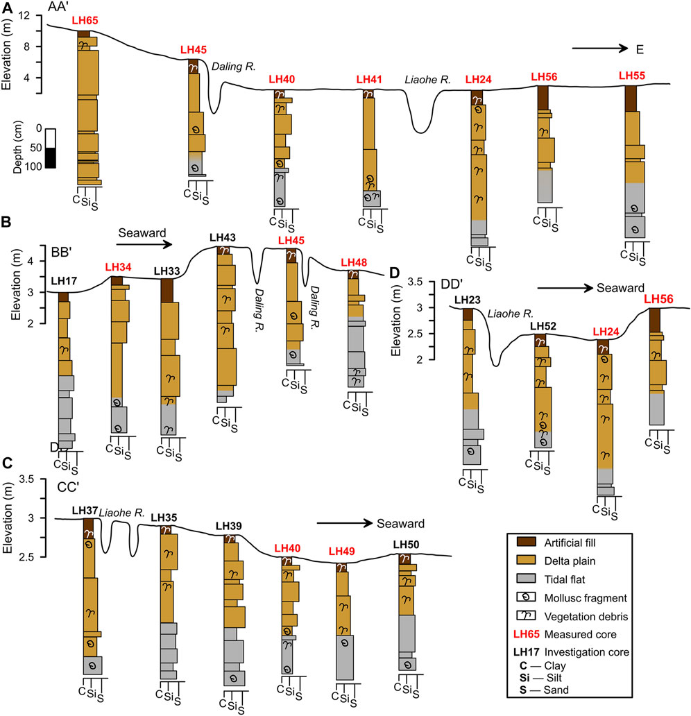
FIGURE 2. Lithology of the core sediments from the four cross sections AA′, BB′, CC′, and DD′ shown in Figure 1.
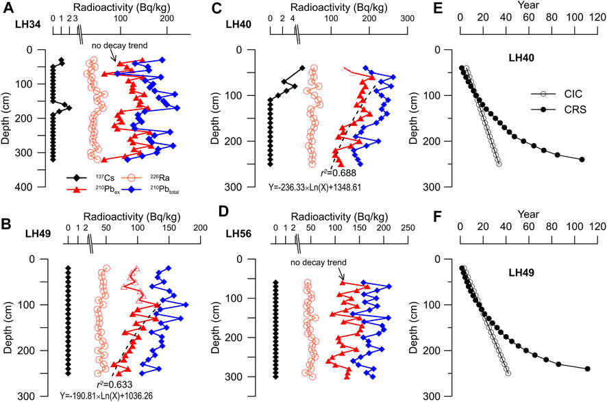
FIGURE 3. Results of 210Pbex, 226Ra, 210Pbtotal, and 137Cs activities for the four representative cores LH34, LH40, LH49, and LH56 (A–D). Dating results of the cores LH40 and LH49 using CIC and CRS models are compared in (E) and (F).
The materials for 210Pb and 137Cs measurement were first homogenized and grinded. 5–9 g of dried sediments were sealed for 4 weeks to secure equilibrium between radon and its daughters prior to measurement. The activity of total 210Pb, 226Ra, and 137Cs was detected using the high-resolution gamma spectrometer (High purity Ge. EG&G Ortec, the United States) at Nanjing Institute of Geography and Limnology, China Academy of Sciences. As 226Ra activity was assumed to be the same as the supported 210Pb, the concentration of the excess 210Pb (210Pbex) was determined by subtracting the total 210Pb activity by 226Ra activity. Two models with assumptions of the constant rate of supply (CRS) and the constant initial concentration (CIC) were used to establish the 210Pb chronology (Krishnaswamy et al., 1971; Appleby and Oldfield, 1978; Robbins, 1978). The 210Pb disintegration constant of 0.03118/a was employed for the calculation of the sedimentation rate. For the CIC model, the uppermost dots characterized as raised 210Pbex activity with the increased depth were excluded for the reconstruction of the age-depth model. For the CRS model, the bulk density of 1.8 g/cm3 was used for all the dried samples.
XRD analysis of clay mineralogy was conducted on a Bruker D2 Phaser X-ray diffractometer equipped with CuKα radiation unit. Chemical treatment was first performed to remove the carbonate and organic matter. The fraction of <2 µm was separated by setting following Stocks’ law. After being concentrated using a centrifuge, the material was smeared on two aliquots, one of which was air-dried, and the other one was mixed with saturated ethylene-glycol over 1 day. XRD measurements were performed with a scanning range of 3–30° 2θ. The step is 0.02° 2θ with the associated residence time of 0.035 s. Semi-quantitative estimation of peak areas of the basal reflections was conducted for the clay mineral groups of smectite (15–17 Å), illite (10 Å), and kaolinite/chlorite (7 Å) on the ethylene glycolate curves (Figure 4B). The relative content of kaolinite and chlorite was calculated using the ratio of 3.57/3.54 Å peak area.
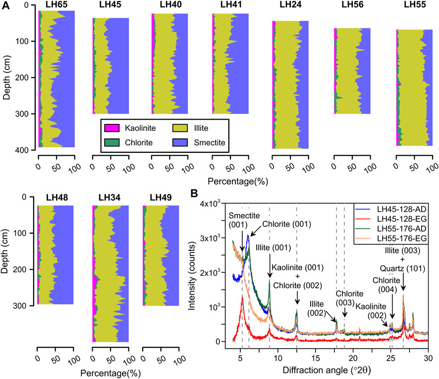
FIGURE 4. (A) Relative content of the four clay minerals: kaolinite, chlorite, illite, and smectite in the core sediments. (B) Glycolate curves for two representative samples LH45-128 and LH55-176.
Non-linear modeling of the clay mineral assemblage in the modern riverine sediments (gray-filled circles in Figure 1B. Liu et al., 2019) was conducted following Yu and Zhang (1998) and Fan et al. (2002). The principle of mass balance of each index was applied in this model to constrain the parameters in the model and to calculate the riverine contributions according to the relative content of the clay minerals in the modern fluvial sediments from the Daling and Liaohe Rivers (Liu et al., 2019). A discriminant was established to distinguish the sediment sources (i.e., the Liaohe or Daling Rivers). The details of the non-linear model are shown as follows.
Supposing there are n source zones, while each source zone has m minerals. The nth source zone sediment concentration percentage is xn, and the percentage of the mth mineral in the nth source region is anm. The mth clay mineral content in the core sediments is bm. According to the sediment balance principle, the relationship could be listed as
In addition, the supply amount
The objective function is expressed as follows:
The restrictions are listed as follows:
In this study, the sources were Liaohe River
while
The calculation accuracy of the contribution rate of each source area is evaluated. Eq. 1 is written as a matrix, which is AX+ε = B. The variance of B can be written as
where E is the unit matrix and
It can be concluded from the above equation that the estimate of the covariance matrix (
Five historical maps and the present satellite image of the NBC were collected to extract information about the paleo-coastlines and river channels in the years 1909 AD, 1926 AD, 1933 AD, 1945 AD, 1956 AD, and the present (Figure 5). All the historical maps were converted to the 1980 Xi’an coordinate system and geo-rectified using the locations of historical towns. The paleo-coastline and river channel were subsequently digitalized and compared with those extracted from the modern imagery (Figure 5).
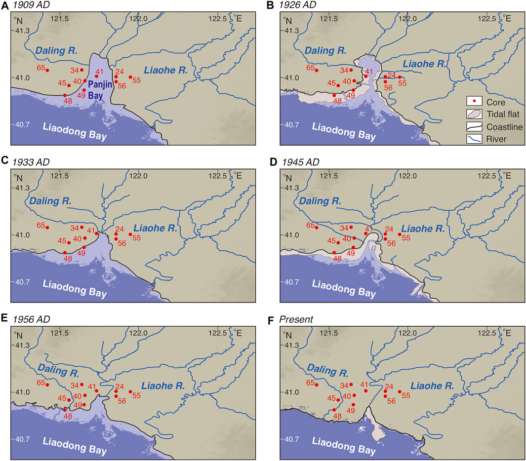
FIGURE 5. Reconstructed coastline and river channels using the historical charts of 1909 (A), 1926 (B), 1933 (C), 1945 (D), and 1956 (E) AD. The present coastline and river channels are extracted from the ASTER digital elevation model (https://lpdaac.usgs.gov/).
210Pbex and 137Cs activities of the sediments in cores LH34, LH40, LH49, and LH56 are shown in Figure 3. 210Pbex activities overall vary between 100 and 200 Bq/kg. 226Ra activities are generally constant for the sediments in each core. 210Pbex and 210Pbtotal activities in cores LH40 and LH49 show a common decay with an increase in depth, which is yet not observed in cores LH34 and LH56 (Figures 3A–D). The upper layer with increased 210Pbex activity downward in cores LH40 and LH49 is regarded as a disturbed layer, which is thus excluded for age determination. Two models were applied for curve fitting and sedimentation rate (SR) calculation. For the CIC model, the 210Pbex activity-depth plot was fitted following logarithmic decay (Krishnaswamy et al., 1971). The mean SRs of 7.37 and 5.95 cm/a were determined for cores LH40 and LH49, for which the coefficient-of-determination (r2) are 0.688 and 0.633, respectively. According to the fitting results using the CIC model, the sediments for cores LH40 and LH49 dated back to the 1980s and 1970s, respectively. For the CRS model, the initial concentration for each core was first calculated. Timing and SR of each layer were then determined (Appleby and Oldfield, 1978; Robbins, 1978). The timing of the sedimentation for cores LH40 and LH49 is ∼100 years (Figures 3E,F).
Compared to 210Pbex, 137Cs peaks were observed in cores LH34 and LH40 with much lower activity of <ca. 4 Bq/kg, while it was too low to be detected for the core sediments in LH49 and LH56. The low activity of 137Cs might induce large uncertainty, so that attempt of constraining the timing of sedimentation in the NBC using the 137Cs dating approach was abandoned in this study.
Clay mineral compositions for the sediments in the ten representative cores are shown in Figure 4A. Illite (18.6–85.3%, average 51.5%) and smectite (4.3–76.3, average 41.0%) are the major clay minerals in the NBC, while the content of kaolinite (0–19.7%, average 3.8%) and chlorite (0–25.9%, average 3.7%) is minor. It agrees with the outcome of Liu et al. (2019), as illite and smectite are the dominant fractions for the modern riverine sediments in the NBC, while the content of chlorite and kaolinite is generally lower than that of ca. 10%. The relative content of illite and smectite shows a negative linear relationship (Figure 6).
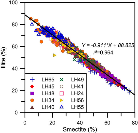
FIGURE 6. Relationship between the content of the two major clay minerals, illite and smectite.
The content of smectite overall decreases from west to east (Figure 4). In vertical, it shows a decreasing upward in the lower part and an increasing upward in the upper part of the cores in the west sub-zone, whilst it demonstrates a gradual increasing upward in the lower part and a decreasing upward in the upper part of the cores to the east. The content of smectite in the eastmost core LH55, at a relatively low level, generally increases upwards. According to the negative linear relationship between assemblages of smectite and illite (Figure 6), the composition of illite varies oppositely in spatial and vertical to the smectite composition. Compared to smectite and illite, relatively minor kaolinite and chlorite are contained in all the core sediments, which do not show obvious variation tendency spatially and vertically (Figure 4).
The Daling riverine sediments tend to contain more smectite than illite, whilst illite is the dominant fraction in the Liaohe originated sediments (Liu et al., 2019). The amounts of the clay mineral groups kaolinite + chlorite, illite, and smectite for the riverine and core sediments are thus plotted in the ternary diagram for preliminary sediment provenance discrimination (Dou et al., 2014; Liu et al., 2019. Figure 7). The clay mineral assemblages for the core sediments in the three sub-zones were plotted in Figures 7B–D. It clearly demonstrates that sediments in the west and east sub-zones provide similar clay mineral compositions to the Daling and Liaohe modern riverine sediments, respectively, whilst in the middle sub-zone mixture of the sediments of different sources is revealed, attributing to contribution from both the two rivers. Clay mineral assemblages show that some sediments in the west sub-zone are characterized as the Liaohe River input, which is likely related to river channel migration and transportation by the longshore current.
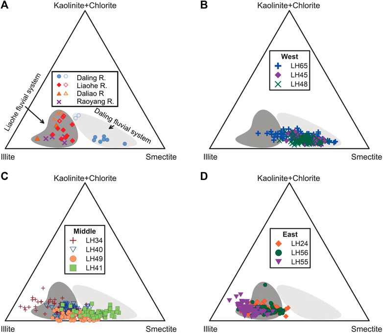
FIGURE 7. Ternary diagrams of the major clay mineral groups: kaolinite + chlorite, illite, and smectite for the (A) modern riverine sediments, and core sediments from the west (B), middle (C), and east (D) of the study area.
The content of the four clay minerals in the modern riverine sediments was used for non-linear discriminant analysis of sediment provenance. The assumption is that the Daling and Liaohe rivers are the two sources of the sediments in the NBC over the last century. The constructed discriminant was then applied to quantify the contribution from the Liaohe and Daling rivers for the core sediments. The contribution ratios of the two rivers are shown in Figure 8. It shows that over 90% of the sediments deposited in the eastern area of the NBC were derived from the Liaohe River, and the rest sediments were transported by the Daling River. The sediments deposited in the western area were mainly derived from the Daling River with a small amount of Liaohe fluvial input (Figure 8) and those in the middle area of the NBC were supplied from both, which are regarded as the major and secondary sediment provenances, respectively. In the upper section of the three cores in CC′, sediments of Daling River origin, varying from 0.01 to 98.92%, tend to increase seawards. It is noticed that sediments in core LH41, close to the modern Liaohe River channel, are discriminated to be supplied mainly by the Daling River (Figure 8).
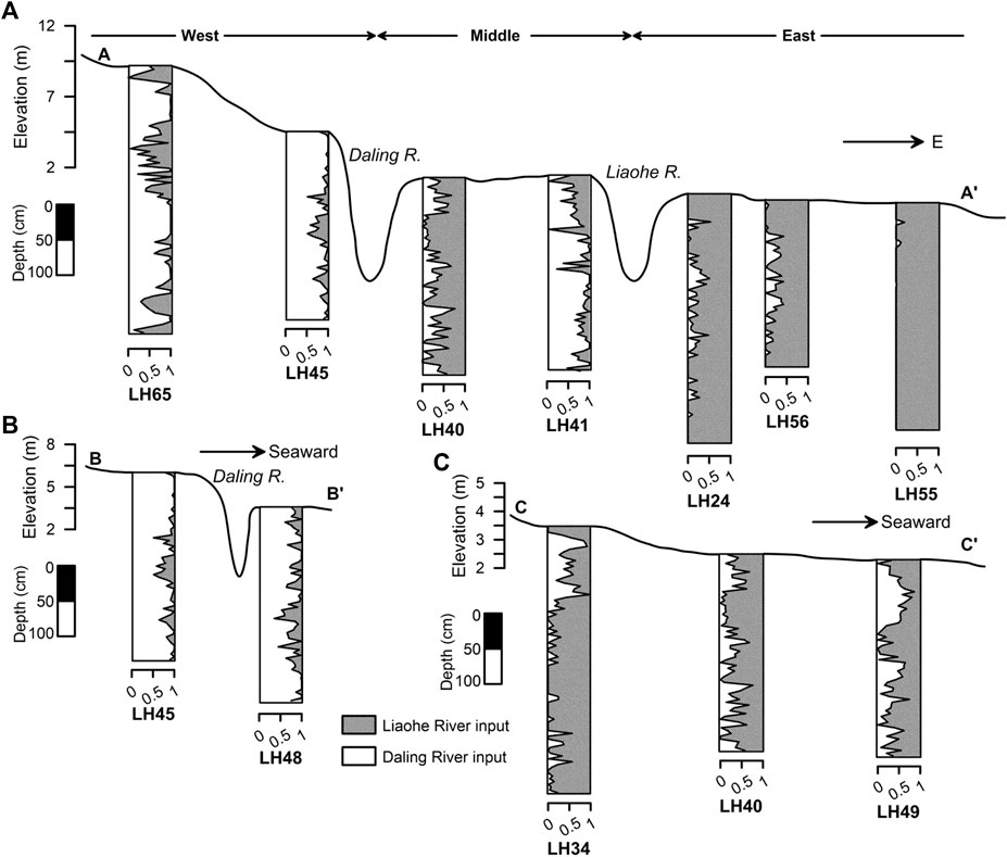
FIGURE 8. Contribution of the Daling and Liaohe rivers to the fine-grained sediments in the NBC determined by the non-linear model.
The information on the coastline and river channel migration was extracted from six images (Figure 5). The so-called ‘Panjin Bay’ was infilled gradually due to progradation during the last century. The Liaohe River and local tributaries generally flow south- and southwest-wards to the Panjin Bay, whilst the channel of the Daling River changed significantly in the last century. Before 1933 AD, the Daling River channel flew eastwards, while the tributary of the Daling River joined those of the Liaohe River and flew into the Panjin Bay westwards. After 1956 AD, the Daling River flows into the Liaodong Bay southwards (Figure 5).
The CIC and CRS modeling results for the sediments in cores LH40 and LH49 show a clear discrepancy, as the mean, SRs determined using the CIC model are much larger than those by CRS modeling (Figures 3E,F). Reliability of the SR by 210Pb dating for the two cores could be assessed by down-core lithological variation and historical coastline migration. It demonstrates that sediment color transition from brownish-gray to light brown upwards in vertical resulted from sedimentary environment change (Figure 2), which was directly induced by the seaward retreat of the coastline. Core LH40 is located between the coastlines of the years 1909 and 1926 AD (Figures 5A,B), for which the boundary of sediment color change is at depth of 205 cm (Figure 2). The mean SR of ca. 1.9 cm/a is thus determined for the upper succession of core LH40 accordingly. The depth of color variation boundary is 180 cm for core LH49 (Figure 2), for which the location is between the coastlines of 1933 and 1945 AD (Figures 5C,D). The mean SR is ca. 2.0–2.3 cm/a. Based on the constraints from lithologic characteristics and coastline migrations, the CIC model yielded SRs larger than 5 cm/a are proven unreliable.
With the mean SRs close to 2.0 cm/a, the results after CRS modeling are more satisfactory compared to that using the CIC model. The timing of the marine-terrestrial transition is 1955 AD for core LH40 and 1970 AD for core LH49 when using the CRS chronological framework for each layer. It implies that the SRs for the upper succession under the terrestrial environment is still overestimated. However, if the mean SR for the whole core was used, the timings of marine-terrestrial transition are 1927 and 1934 AD for cores LH40 and LH49, respectively, which are in general consistent with the age constraints by lithology and geomorphology.
SR overestimation for 210Pb dating is also evidenced by the previously published dating results using optically stimulated luminescence (OSL) and accelerator mass spectrometry radiocarbon-14 (AMS14C) dating approaches. Numerical ages and depths of the uppermost chronological samples in the cores in the NBC were used to calculate the mean SRs in the last few centuries (Li et al., 2014; Ma et al., 2016; He et al., 2018; Li Y. et al., 2018). It shows that the SRs were generally smaller than 2 cm/a in the NBC in the late Holocene. Furthermore, 210Pb and 137Cs dating approaches have been successfully conducted on the sediments in the NBC by Li H. et al. (2019), which suggested that the SR was ca. 1.6–2.7 cm/a for the studied cores sediments. SR overestimation of 210Pb chronology is likely attributed to the un-negligible external input of 210Pb due to the complex hydrodynamics in the coastal area (Wang et al., 2016). It results in either an unclear decay trend of 210Pbex activity (i.e. cores LH34 and LH56) or overestimated SRs using inappropriate age model (i.e. cores LH40 and LH49) in this study (Figure 3).
Overall, by comparing the 210Pb dating results with the lithological constraints and other results by numerical dating, 210Pb dating using the CIC model failed to constrain the timing of the sedimentation in the NBC over the last century in this study. This is probably due to the unstable sedimentary environment and complex marine-terrestrial exchange in the coastal area. CRS model seems to yield slightly overestimated SR, as the SR increased over the last century, which is in contradiction with the declined fluvial sediment flux. However, the mean SR appears to be reliable, for which the timing of the marine-terrestrial transitional boundary agrees with that constrained by the history of coastline retreats.
The NBC receives sediments from the Liaohe and Daling rivers, which stretch across the monsoon and non-monsoon regions in northern China, where the climate condition of the drainage basins possibly induces physical erosion of the bedrocks. Smectite and illite are the two major clay minerals contained in the sediments in the NBC, which correlate to the Daling and Liaohe rivers as the two end-members of the sediment sources (Liu et al., 2019). Limited by the range of the drainage basin, it is clear that the core sediments collected from the east NBC correspond to major contribution of the Liaohe River, while those from the west NBC are mainly derived from the Daling River (Figures 7B,D). In contrast, the clay minerals in the core sediments were derived from both the two rivers in the middle zone of the study area (Figure 7C), which were induced by fluvial and coastal morphologic evolution over the last century.
The coastal morphological evolution in the NBC over the last century was reconstructed using the two dated cores and the adjacent cores, in conjunction with the information on the historical coastline and river channel migration. Based on the 210Pb chronology after CRS modeling, variation of the river input is shown in Figure 9. It demonstrates that clay minerals in the two cores have documented consistent variation of the fluvial contribution. The Panjin Bay was infilled by the sediments from the two rivers since 1909 AD, which resulted in significant coastal morphological change. During this period, the Daling River flew eastward, while the Liaohe and its local tributaries flew into the Panjin Bay south- and westwards (Figure 5). Transported by fluvial input and the coastal current in the Panjin Bay, clay minerals from the offshore cores LH40, LH41, and LH49 showed a mixture of the Daling and Liaohe River sources. With further infilling of the Panjin Bay, the coastline in the west Panjin Bay retreated seawards significantly, resulting in an increase of the Daling River input during 1909–1926 AD (Figure 9). It is also noticed that sediments in the cores closer to the Daling estuary responded earlier. From 1926 to 1933 AD, the north coast of the Panjin Bay was rapidly filled mainly by sediments of Liaohe origin after comparing the coastline migration during the period (Figures 5B,C). Consistently, the relative contribution of the Daling River declined in cores LH40 and LH49 according to the non-linear modeling. The river channel of the Daling River migrated during 1933–1945 AD southeastward, which induced increasing river input to the area where cores LH40 and LH49 were located. Based on the outcome of provenance discrimination, the migration was relatively rapid, as the response in the two cores was possibly simultaneous (Figure 9). Since the Daling River further flew to the Liaodong Bay southward, the influence on the area of cores LH40 and LH49 from the Daling River became weaker, which correlates to an increase in Liaohe contribution as revealed by the modeled provenance quantification. In summary, with a comparison between the historical morphological change and the outcome of provenance discrimination, the Daling River input was major in the 1910s and 1940s, which attributed to the rapid progradation and river channel migration, respectively. Although the tendency of fluvial contribution in different cores is in agreement, it is shown that the fluvial contribution of clay minerals is related to the relative position between the estuary and the cores. During 1909–1945 AD, the Daling estuary was close to the location of core LH40, leading to more fluvial contribution in core LH40 from the Daling river. On the contrary, the Daling estuary migrated southward after 1945 AD, which was closer to core LH49. This resulted in more Daling River input in core LH49 compared to core LH40.
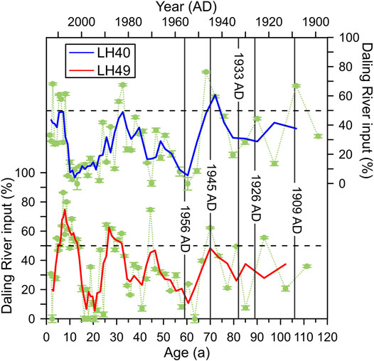
FIGURE 9. Reconstruction of the Daling River contribution in the last century using the two dated cores LH40 and LH49. The solid lines in blue and red demonstrate a 3-point running average.
The consistency between the non-linear modeling results, the river channel, and coastal migration has been also reflected by the adjacent cores without direct dating results. For instance, non-linear modeling of the provenance discrimination shows that the fine-grained sediments in core LH41, that is close to the modern Liaohe River channel (Figure 1), originated mainly from the Daling River (Figure 8). Based on the information on the historical river channel, the Daling River flew into the Panjin Bay southeastwards before 1956 AD, resulting in progradation southeastward and infillling of the Panjin Bay between 1909–1956 AD (Figure 5). The majority of sediments in core LH41 of the Daling riverine contribution attributes to its location in the estuary of the Daling River during 1909–1956 AD. It is also noticed that the tributary of the Daling River joined those of the Liaohe River and flew into the Panjin Bay westwards revealed by the historical map in 1945 AD (Figure 5D). It resulted in minor input from the Daling River on the east coast of Panjin Bay (LH24 and LH56. Figure 8). After 1956 AD, the relative contribution of the Daling River increased at least twice. i.e., in the 1980s and 2000s (Figure 9). It might be related to flood events, e.g., the flood in the year of 1984, or anthropogenic impact, which needs more detailed investigation. Overall, it indicates that the determination of the riverine input for the two rivers after non-linear modeling is consistent with the reconstructed historical river channel and coastline migration.
The NBC is one of the depocenters in the Bohai Sea. The thick sediments contain rich paleoenvironmental information (Liaoning Geological Bureau, 1983; IOCAS, 1985). According to the discussion abovementioned, clay mineralogy is useful to discriminate the provenance and reconstruct morphological evolution. Meanwhile, clay minerals as one of the applicable environmental proxies could be also used to investigate the paleoclimate change and sediment transportation process (e.g., Liu et al., 2003; Li J. et al., 2018; Yu et al., 2019), which is, however, has not been used to interpret paleoenvironment change in the NBC.
The variation of the clay mineral assemblages is not correlated to paleoclimatic change/chemical weathering conditions straightforwardly (Thiry, 2000; Liu et al., 2003). For the purpose of paleoenvironmental investigation using clay mineralogy in the NBC, it is essential to separate the sediments with a single origin from those with mixed sources. To simplify the non-linear model in this study, the contributions of Daling and Liaohe rivers were presented as the content ratio of smectite/illite. The ratio was plotted against the determined contribution of the two rivers (Figure 10). Sediments most likely derive from the Liaohe River when the smectite/illite ratio is lower than 0.5, while those are solely associated with Daling River input when the ratio is higher than 1.7. A logarithm correlation of smectite/illite ratio with the percentage of river input for both the rivers is observed for the ratio range between 0.5–1.7. The correlation with fitting equations shown in Figure 10 can be potentially applied to quantitatively discriminate the contributions of fluvial inputs for the quaternary provenance-unknown sediments in the NBC, and further extract the clay mineral content derived from the signal provenance.
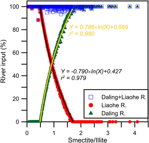
FIGURE 10. Quantification of the contribution of the river input using the ratio of smectite content over illite content.
In this study, the clay mineralogy of the coastal sediments in the North Bohai Coast (NBC) was investigated to determine the variation of the fine-grained sediment sources over the last century. Clay mineral content in the modern riverine sediments in the NBC was used to discriminate the sediment provenance and to quantify the sedimentary contribution from different fluvial systems. 210Pb and 137Cs radioactivity was measured for the dating attempt. The migration of coastline and river channel in the North Bohai Coast during the last hundred year was reconstructed by digitalizing the historical charts and satellite images. The main conclusions are drawn as follows:
• 210Pb chronology after CIC modeling overestimates the sedimentation rate, but the CRS model results in an acceptable sedimentation rate for two dated cores. 137Cs dating approach is not applicable due to the low activity of the nuclide.
• Contribution of the Daling and Liaohe Rivers has been quantified using non-linear modeling of the clay mineral contents. The modeling results demonstrate a satisfactory relationship with the smectite/illite content ratio, which is also consistent with the lithological and coastal geomorphologic constraints.
• Clay minerals in western and eastern NBC are mainly derived from the Daling and Liaohe Rivers, respectively. In the middle NBC, the Daling River input was relatively major during the 1910s, 1940s, 1980s, and 2000s. The increase of Daling River input in the first two periods resulted from progradation and river channel migration, respectively.
• Increasing fluvial contribution from the Daling River in 1980s and 2000s might be related to flooding events and/or anthropogenic impact, which needs more investigations. The fluvial contribution from the Liaohe River was major in the middle NBC during 1920–1940 AD, likely attributing to rapid progradation. River channel migration of the Daling River after 1956 AD likely resulted in a relative increase of Liaohe River input during 1950–1970 AD, as the influence on the middle NBC from the Daling River was weaker.
The raw data supporting the conclusion of this article will be made available by the authors, without undue reservation.
Conceptualization and methodology, YL and DL; formal analysis, SS, DL, KH, and YL; original draft preparation, YL, DL and SS; and review and editing, KH and YL. All authors have read and agreed to the published version of the manuscript.
This work was supported by the National Natural Science Foundation of China (41907376), Beijing Natural Science Foundation (8204070), and the 111 Project (B20011).
The authors declare that the research was conducted in the absence of any commercial or financial relationships that could be construed as a potential conflict of interest.
All claims expressed in this article are solely those of the authors and do not necessarily represent those of their affiliated organizations, or those of the publisher, the editors, and the reviewers. Any product that may be evaluated in this article, or claim that may be made by its manufacturer, is not guaranteed or endorsed by the publisher.
The authors are grateful to the two reviewers and editor XL for their construction comments and help. YL was supported by the Excellent Chinese and Foreign Young Scientist Exchange Program of China Association of Science and Technology (CAST). Lei Bi of Tongji Universtiy, Jacquie Drake, Norman MacLeod, Yingying Deng, Huiqing Xu, Changhong Jiang, Zhaoyu Yang of Nanjing University, and Yunfeng Nie and Liya Zhu of China University of Geosciences are thanked for their suggestions on the very early version of this manuscript.
Appleby, P. G., and Oldfield, F. (1978). The Calculation of lead-210 Dates Assuming a Constant Rate of Supply of Unsupported 210Pb to the Sediment. Catena 5, 1–8. doi:10.1016/s0341-8162(78)80002-2
Biscaye, P. E. (1965). Mineralogy and Sedimentation of Recent Deep-Sea Clay in the Atlantic Ocean and Adjacent Seas and Oceans. Geol. Soc. America Bull. 76 (7), 803–832. doi:10.1130/0016-7606(1965)76[803:masord]2.0.co;2
Cai, G., Li, S., Zhao, L., Zhong, L., and Chen, H. (2020). Clay Minerals, Sr-Nd Isotopes and Provenance of Sediments in the Northwestern South China Sea. J. Asian Earth Sci. 202, 104531. doi:10.1016/j.jseaes.2020.104531
Chen, Y., Fang, G., Ni, J., and Hu, K. (2010). Research on century's Changes of Coastlines of Liaohe Estuary. J. Mar. Sci. 28, 14–21.
Cho, H. G., Kim, S.-O., Kwak, K. Y., Choi, H., and Khim, B.-K. (2015). Clay mineral Distribution and Provenance in the Heuksan Mud belt, Yellow Sea. Geo-mar Lett. 35 (6), 411–419. doi:10.1007/s00367-015-0417-3
Colin, C., Turpin, L., Blamart, D., Frank, N., Kissel, C., and Duchamp, S. (2006). Evolution of Weathering Patterns in the Indo-Burman Ranges over the Last 280 Kyr: Effects of Sediment Provenance on 87Sr/86Sr Ratios Tracer. Geochem. Geophys. Geosystems 7 (3), 1–16. doi:10.1029/2005gc000962
Dou, Y., Li, J., Zhao, J., Wei, H., Yang, S., Bai, F., et al. (2014). Clay mineral Distributions in Surface Sediments of the Liaodong Bay, Bohai Sea and Surrounding River Sediments: Sources and Transport Patterns. Continental Shelf Res. 73, 72–82. doi:10.1016/j.csr.2013.11.023
Fan, D., Sun, X., Yang, Z., and Guo, Z. (2002). A Mathematical Model on the Quantitative Provenance Identification──Take the Identification of the Surface Sediment Sources from ECS as Example. Acta Sedimentologica Sinica 1, 30–33. (in Chinese with English abstract).
Gray, H. J., Jain, M., Sawakuchi, A. O., Mahan, S. A., and Tucker, G. E. (2019). Luminescence as a Sediment Tracer and Provenance Tool. Rev. Geophys. 57, 987–1017. doi:10.1029/2019rg000646
He, L., Xue, C., Ye, S., Laws, E. A., Yuan, H., Yang, S., et al. (2018). Holocene Evolution of the Liaohe Delta, a Tide-Dominated delta Formed by Multiple Rivers in Northeast China. J. Asian Earth Sci. 152, 52–68. doi:10.1016/j.jseaes.2017.11.035
Hu, B., Li, J., Cui, R., Wei, H., Zhao, J., Li, G., et al. (2014). Clay Mineralogy of the Riverine Sediments of Hainan Island, South China Sea: Implications for Weathering and Provenance. J. Asian Earth Sci. 96, 84–92. doi:10.1016/j.jseaes.2014.08.036
IPCC (2014). Climate Change 2014: Impacts, Adaptation, and Vulnerability. New York, USA: Intergovernmental Panel on Climate Change.
Jacobsen, S. B., and Wasserburg, G. J. (1980). Sm-Nd Isotopic Evolution of Chondrites. Earth Planet. Sci. Lett. 50, 139–155. doi:10.1016/0012-821x(80)90125-9
Kissel, C., Liu, Z., Li, J., and Wandres, C. (2016). Magnetic Minerals in Three Asian Rivers Draining into the South China Sea: Pearl, Red, and Mekong Rivers. Geochem. Geophys. Geosyst. 17 (5), 1678–1693. doi:10.1002/2016gc006283
Krishnaswamy, S., Lal, D., Martin, J. M., and Meybeck, M. (1971). Geochronology of lake Sediments. Earth Planet. Sci. Lett. 11, 407–414. doi:10.1016/0012-821x(71)90202-0
Li, H., Li, L., Su, F., Wang, T., and Gao, P. (2019). The Periodic Response of Tidal Flat Sediments to Runoff Variation of Upstream Main River: A Case Study in the Liaohe Estuary Wetland, China. Water 12 (1), 61. doi:10.3390/w12010061
Li, J., Liu, S., Shi, X., Zhang, H., Fang, X., Chen, M.-T., et al. (2018). Clay Minerals and Sr-Nd Isotopic Composition of the Bay of Bengal Sediments: Implications for Sediment Provenance and Climate Control since 40 Ka. Quat. Int. 493, 50–58. doi:10.1016/j.quaint.2018.06.044
Li, P., and Xu, Y. (2014). Evolution of Paleoenvironment since Late Pleistocene 24 Ka of LH01 Core in the Northern Liaodong Bay. Adv. Mar. Sci. 32, 59–67. (in Chinese with English abstract).
Li, Y., Shang, Z., Tsukamoto, S., Tamura, T., Yi, L., Wang, H., et al. (2018). Quartz and K-Feldspar Luminescence Dating of Sedimentation in the North Bohai Coastal Area (NE China) since the Late Pleistocene. J. Asian Earth Sci. 152, 103–115. doi:10.1016/j.jseaes.2017.10.036
Liu, B., He, Y., Zhang, Y., Sun, Y., Wang, Y., and He, D. (2020). Natural and Anthropogenic Organic Matter Cycling between Coastal Wetlands and Rivers: a Case Study from Liao River Delta. Estuarine. Coastal Shelf Sci. 236. doi:10.1016/j.ecss.2020.106610
Liu, D., Liu, X., Hu, K., and Liu, H. (2019). A Study of clay Minerals in Estuarine Sediments of Daling River and Liaohe River. Haiyang Xuebao 41 (2), 75–84. (in Chinese with English abstract).
Liu, X., Li, A., Dong, J., Lu, J., Huang, J., and Wan, S. (2018). Provenance Discrimination of Sediments in the Zhejiang-Fujian Mud belt, East China Sea: Implications for the Development of the Mud Depocenter. J. Asian Earth Sci. 151, 1–15. doi:10.1016/j.jseaes.2017.10.017
Liu, Z. F., Trentesaux, A., Clemens, S. C., Colin, C., Wang, P. X., Huang, B. Q., et al. (2003). Clay mineral Assemblages in the Northern South China Sea: Implications for East Asian Monsoon Evolution over the Past 2 Million Years. Mar. Geology. 201 (1-3), 133–146. doi:10.1016/s0025-3227(03)00213-5
Ma, H., Che, J., Ma, S., Cui, J., Wang, C., and Dai, Y. (2016). Holocene Environmental Changes Revealed by Core LZK03 in the Liao River Delta. Geol. Bull. China 35, 1571–1577. (in Chinese with English abstract).
Milliman, J. D., and Syvitski, J. P. M. (1992). Geomorphic/tectonic Control of Sediment Discharge to the Ocean: the Importance of Small Mountainous Rivers. J. Geology. 100, 525–544. doi:10.1086/629606
Robbins, J. A. (1978). “Geochemical and Geophysical Applications of Radioactive lead,” in The Biogeochemistry of Radioactive Lead in the Environment. Editor J. O. Nriagu (New York: Elsevier), 285–393.
Thiry, M. (2000). Palaeoclimatic Interpretation of clay Minerals in marine Deposits: an Outlook from the continental Origin. Earth-Science Rev. 49, 201–221. doi:10.1016/s0012-8252(99)00054-9
Wang, F., Zong, Y., Li, J., Tian, L., Shang, Z., Chen, Y., et al. (2016). Recent Sedimentation Dynamics Indicated by 210Pbexc and 137Cs Records from the Subtidal Area of Bohai Bay, China. J. Coastal Res. 32 (2), 416–423.
Wang, Z., Zheng, H., Mei, X., Meng, X., Xu, T., Wang, Z., et al. (2020). Sedimentary Environment Evolution and Provenance Analysis of Northwestern Liaodong Bay from the Middle Pleistocene. Quat. Int. 589, 55–67.
Yu, L., and Zhang, W. (1998). Magnetic Diagnostic Model for Quantitative Analysis of Sediment Source Composition. Chin. Sci. Bull. 43 (19), 2034–2041. (in Chinese with English abstract).
Yu, Z., Colin, C., Wan, S., Saraswat, R., Song, L., Xu, Z., et al. (2019). Sea Level-Controlled Sediment Transport to the Eastern Arabian Sea over the Past 600 Kyr: Clay Minerals and Sr Nd Isotopic Evidence from IODP Site U1457. Quat. Sci. Rev. 205, 22–34. doi:10.1016/j.quascirev.2018.12.006
Keywords: clay mineralogy, provenance, historical charts, non-linear programming modeling, paleoenvironmental change, North Bohai Coast
Citation: Sun S, Li Y, Liu D and Hu K (2022) Clay Mineralogical Records in the North Bohai Coast of China in the Last Century: Sediment Provenance and Morphological Implications. Front. Earth Sci. 10:865839. doi: 10.3389/feart.2022.865839
Received: 30 January 2022; Accepted: 04 April 2022;
Published: 12 May 2022.
Edited by:
Xiting Liu, Ocean University of China, ChinaCopyright © 2022 Sun, Li, Liu and Hu. This is an open-access article distributed under the terms of the Creative Commons Attribution License (CC BY). The use, distribution or reproduction in other forums is permitted, provided the original author(s) and the copyright owner(s) are credited and that the original publication in this journal is cited, in accordance with accepted academic practice. No use, distribution or reproduction is permitted which does not comply with these terms.
*Correspondence: Yan Li, eWFuLmxpQGN1Z2IuZWR1LmNu; Dawei Liu, bGR3ODYxMTExQDE2My5jb20=
Disclaimer: All claims expressed in this article are solely those of the authors and do not necessarily represent those of their affiliated organizations, or those of the publisher, the editors and the reviewers. Any product that may be evaluated in this article or claim that may be made by its manufacturer is not guaranteed or endorsed by the publisher.
Research integrity at Frontiers
Learn more about the work of our research integrity team to safeguard the quality of each article we publish.