- 1College of Urban and Environmental Sciences, Northwest University, Xi’an, China
- 2Yellow River Institute of Shaanxi Province, Northwest University, Xi’an, China
- 3Faculty of Geosciences and Environmental Engineering, Southwest University, Chengdu, China
There is a coupling mechanism among geohazards, rural settlements, and cultivated land in mountainous areas in the upper reaches of the Min River by analyzing geohazards data, settlements data and cultivated land data. Geohazards change the landform and provide material basis and space for the occurrence and development of cultivated land and settlements. However, human production and life are not only stressed by geohazards, but also one of the main factors inducing geohazards. The Settlements in the upper reaches of the Min River can be categorized into production-stressed settlements and life-stressed settlements. With the transformation of the social economy and society’s attention to the ecological function of the region, geohazards risk management of life-stressed settlements is of more importance. The “two-wheel-drive” strategy of new urbanization and rural revitalization provides opportunities for rural development in mountainous areas and also changes the role of land in human-land relationships. To fully consider natural capital in the sustainable livelihoods of farmers, it is necessary to evaluate the risk degree of geohazards in settlements at the small catchment scale and improving the external connectivity of the settlements, which is the key for promoting the optimization of natural environmental assets in these mountain settlements.
Introduction
Disaster reduction is an integral component of sustainable development, to reduce social, economic, and environmental losses due to natural hazards and related technological and environmental disasters (Twigg, 1999; Armstrong, 2000; Paton et al., 2000; Klein et al., 2004; United Nations Office for Disaster Risk Reduction, 2005). Community-based disaster risk management (CBDRM) is a common approach to international disaster prevention and reduction, which was first established in the UK in the late 1980s and has since been widely applied by international, national, and local organizations (Mimaki et al., 2009; Tiwari, 2015). The main idea of CBDRM is to rely on community organizations to mobilize residents to participate in the construction of community disaster prevention and reduction with the support of governments and non-government groups (Ikeda et al., 2008; Sha and Liu, 2010; Hossain, 2013). Current research of CBDRM focuses on the construction of disaster prevention and reduction systems (Chen and Cui, 2013), comparisons of the reconstruction modes (Liu et al., 2017), architecture and planning design strategy of post-disaster temporary settlement (Huang and Long, 2015), innovations in management mechanisms (Gao, 2013; Xu et al., 2020), capacity-building for disaster prevention and reduction (Yin et al., 2009; Xia, 2010; Zhou et al., 2010; Fei, 2015), disaster prevention awareness (Liu, 2010), risk perception to environmental hazards (Peng et al., 2018; Ahmed et al., 2019), disaster risk and adaption of settlement (Utami et al., 2014), disaster prevention behaviors of rural households (Long and Zhuang, 2009; Zhang, 2013; Wu, 2015), vulnerability assessment for debris flows (Ding, et al., 2016), and factors influencing flood impacts in settlements (Dalu et al., 2018). However, few studies have attempted to comprehend the change of the impact of geohazards on sustainable development from the macro perspective when society and economy transformed.
The interactions between human society and geohazards are dynamic. With the transformation of the social economy, the intensity and mode of human utilization of natural resources have changed. Especially with urbanization, the national economic development strategy has been transformed into ecological civilization construction (Pan, 2016), which promotes sustainable development of green development, and urban-rural integrated development (Li, 2011). Rural spaces and resources therein are being developed to meet the urban demand for rural areas (Holmes, 2006), changing uses of rural land to supporting secondary products, leisure, and entertainment, affecting the livelihood of farmers in mountainous areas (Liu et al., 2018). The impact of these changes will affect the composition of farmers’ livelihood assets (or capital), and the focus of community-based disaster risk management will also change.
The village, a basic type of settlement, is a place-based community with the totality of individuals and social structures within a specific geographical location. Rural settlements in mountainous areas are the product of human adaptation to the environment (Jin, 1988). Located in the mountainous areas with fragile environments and frequent geohazards (such as collapse, unstable slope, landslides and debris flow), and the beautiful natural landscape and unique folk culture, the socio-economic development of a village is a balance of coping with various adverse conditions with the development of rural tourism (Liu et al., 2018). With China entering the middle stages of industrialization, the environment in mountainous areas has increasingly become a part of livelihood capital, which is an important barrier for farmers to resist various risk shocks (Yang and Zhao, 2009), especially in ethnic minority areas, consisting of both the material and immaterial contents (Li et al., 2019). The development of the tourist industry, based on resources such as the natural landscape and folk culture (Xu et al., 2020), has reduced the stress of natural disasters on livelihood. The ability to absorb the effects of pressure sources through resilience or adaptation has become one of the main capabilities of some communities (Twigg, 1999).
This paper analyzes the coupling relationship and mechanisms between the spatial distribution of mountain settlements and geohazards in the upper reaches of the Min River on a regional scale. This provides a basis for the sustainable development of mountain villages in the transition period, in which the society transforms from the subsistence agricultural society to service-oriented industrial and commercial society (Lu, 1997).
Materials and Methods
Study Area
The upper reaches of the Min River refers to the reaches above Dujiangyan, bounded by the latitudes 30°45′–33°09′ N and the longitudes 102°35′–103°56′ E, covering an area of about 22,000 km2 in the southeast margin of Qinghai-Tibet Plateau. Features include complex geological structures and fault developments (Figure 1). Areas covered by the tributaries include Wenchuan County, Li County, Heishui County and the major part of Songpan County and Mao County, which are all in the Aba Tibetan Autonomous Prefecture, and a small part of Dujiangyan City (the five counties listed are the focus of this paper). The terrain in the area is high in the west and low in the east; the elevation range is 734–6,153 m (Figure 2).
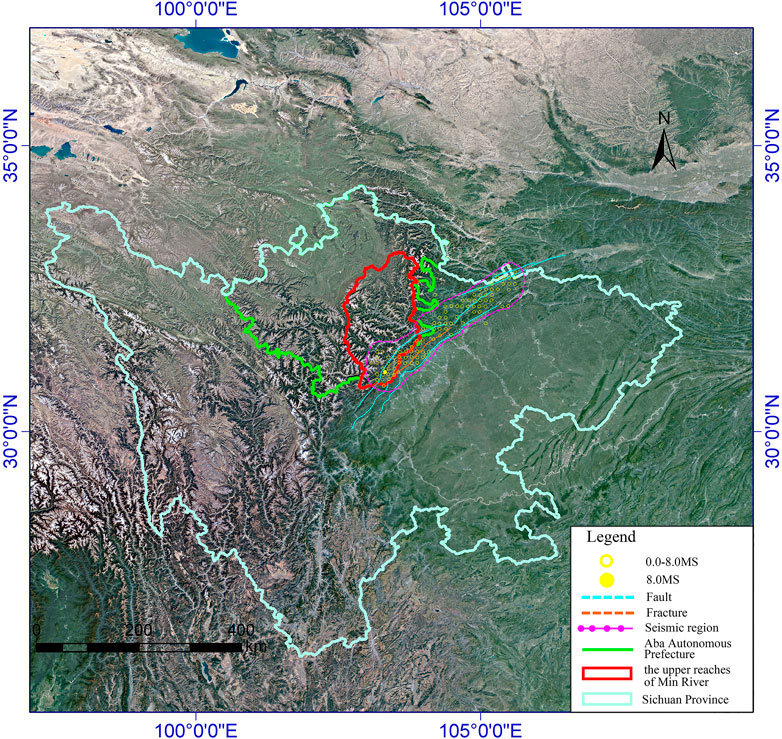
FIGURE 1. Location of the upper reaches of Min River (according to Cui, 2011).
The study area, with an azonal arid valley climate, is characterized by a dry and windy climate, cold in winter and cool in summer, with large temperature differences between day and night, regions, and altitudes. Because of the control of westerly circulation and the monsoon warm current, the climate transitions from the subtropics to a warm temperate zone and then to a cold temperate zone; it demonstrates a climate distribution form of echelonment (Ding et al., 2014). The annual mean temperature of the area is 5.7–13.5°C, and annual precipitation is 400–800 mm for which 80% is concentrated in the period from May to October (Ding et al., 2014). Due to the foehn effect caused by a deep valley and large relative elevation difference, the warm and humid airflow in the southeast and southwest is separated by the mountains, which is not conducive to the formation of precipitation in the valley. Precipitation is relatively abundant in the high mountain areas. The multi-year average precipitation in the northwest of Heishui County is ∼1,200 mm, and coupled with Mao County is the precipitation center, which gradually increases to the southeast and northwest (Ding et al., 2014).
Geohazard Data
The China Geological Survey from May 2008 to April 2017 was used to classify types of geohazards (Table 1; Figure 3). By 2017, 824 collapses were documented in five counties in the upper reaches of the Min River, with a maximum scale of 300 × 104 m3 and a minimum scale <1 m3. Among them, small collapses account for 79.3%, whereas giant collapses, large-scale collapses, and medium-scale collapses account for 0.24, 2.42, and 17.96%, respectively.

TABLE 1. The scale and classification standard of landslides, collapses, unstable slopes, and debris flow.
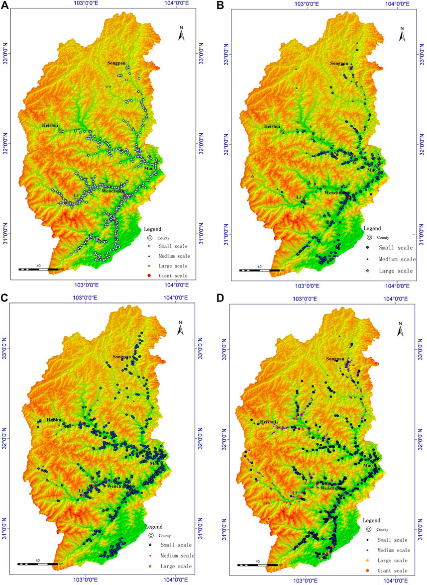
FIGURE 3. The distribution of collapses (A), unstable slopes (B), landslides (C), and debris flows (D) in the upper reaches of the Min River.
There were 579 unstable slopes, and the maximum number of people threatened is 800. The unstable slopes in this area are divided into three grades: small, medium, and large. The percentages of medium-scale and small-scale unstable slopes were 48.8 and 45.3% respectively, and large-scale accounted for 5.9%.
There were 921 landslides, with a maximum scale of 540 × 104 m3 and a minimum scale <1 m3. Small-scale landslides accounted for the majority (83.3%) of the total number of collapses; large- and medium-scale collapses accounted for 14.7 and 2%.
There were 841 debris flows, with a maximum scale of 200 × 104 m3 and a minimum scale of 0.01 m3. Small-scale debris flows accounted for the vast majority (54.2%) of the total number; medium-scale, large-scale and giant-scale debris flows accounted for 38.6, 5, and 2.1%, respectively.
The grading standard here is slightly modified according to Zhang et al. (2002) in which the unstable slope is graded according to the number of people threatened.
Settlement and Cultivated Land
People belong to Tibetan, Qiang, Hui, and Han ethnicities, and the area has a diversified economy and many cultures (Wu et al., 2003). According to the data of the sixth census, there were more than 320,000 people in the five counties in 2010. Because of the high mountains and valleys, people build settlements along the river valley, with the distribution affected by natural and geographical conditions. The settlement locations vary in altitude, forming mountain villages or mountain market towns with a hyper-normal vertical distribution of rural settlements (Ding et al., 2014). The size of villages is small, mainly because of the undulating mountainous terrain, the flat land is confined, and topographic conditions are challenging for building large villages. The residential buildings in this area are mostly stone or Earth rock, with attractive appearances in form and structure and with unique landscape values. The bottom of the valley of the river also is the location of agricultural activity (Ding and Hu, 2020). Affected by the terrain and limited water and soil resources, there is less flat cultivated land, and terracing is common.
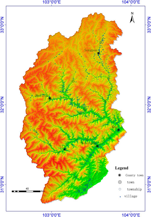
The distribution data of point settlements were manually extracted from 91 satellite map software. The location of settlements was represented by the administrative village committee in the local area (Figure 4). The cultivated land data was 1:10,000 in vector form from the land management department.
Methods
Frequency–Elevation Relations
Each geological hazard, village, and cultivated land were labeled. Using ArcGIS software and high-precision DEM data, the joint distribution of settlement, geohazard and cultivated land area with elevation were obtained. We calculated the number of geohazards, settlements and cultivated land area according to the elevation range of 200 m.
Correlation Analysis
With the joint distribution of settlement, geohazard and cultivated land area with elevation obtained above, the Pearson correlation coefficient r between the number of settlements and cultivated land area and between the number of settlements and each type of geohazards were calculated, with professional statistical software SPSS. The specific formula is:
where
Results
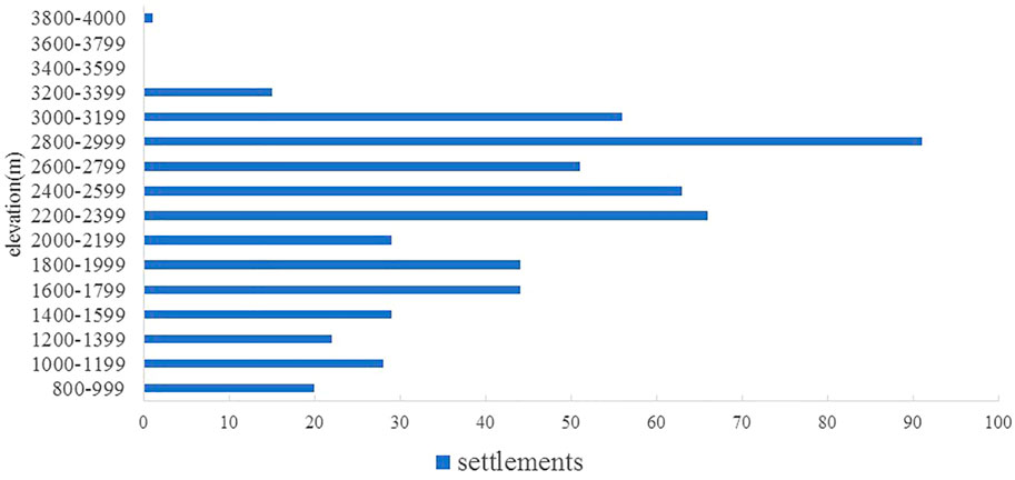
A total of 559 settlements were distributed from 870 to 3,900 m in 2020 (Figure 5). There were 91 settlements distributed in 2,800–3,000 m (16.279% of the total number); settlements distributed 2,200–3,200 m account for 58.497%. Table 2 shows the number of settlements and cultivated land area distribution at different elevations. There was high correlation between the number of settlements and cultivated land area (r = 0.814, p = 0.000).

TABLE 2. Distribution of settlement numbers and cultivated land area with elevation in the upper reaches of the Min river.
Figure 6 shows the spatial distribution of geohazards of collapses, unstable slopes, landslides, debris flows, and settlements in the upper reaches of the Min River. At the regional scale, the distribution of geohazards and settlements has substantial overlap. Settlements and geohazards are mainly distributed along the river valley.
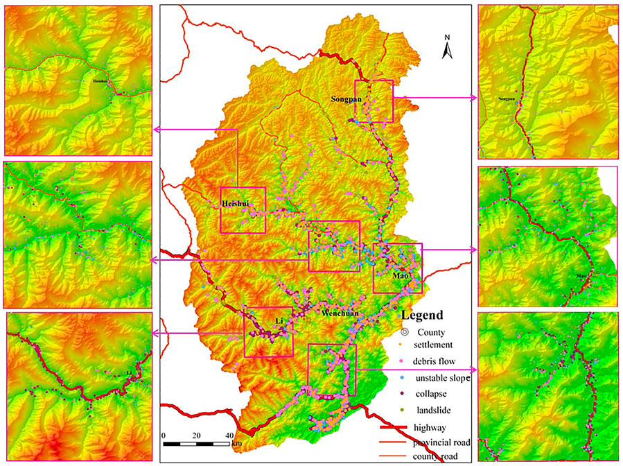
FIGURE 6. The distribution of collapses, unstable slopes, landslides, debris flows, and settlements in the upper reaches of the Min River.
Figure 7 show the distribution of collapses, landslides, unstable slopes, debris flows, and settlements by elevation. The elevation range of settlements was 870–3,900 m. The elevation range of geohazards was 850–3,850 m, with collapses 890–3,300 m, landslides 870–3,510 m, unstable slopes 880–3,330 m, and debris flow 850–3,840 m. The highest frequency of settlements was at 2,800–3,000 m; whereas collapse, landslide, unstable slope, and debris flow elevation had the highest frequency at 1,600–1800 m, and the unstable slope variable has a second maximum at 2000–2,200 m. In general, settlements are found more frequently at higher elevations and disasters at lower elevations (Figure 7).
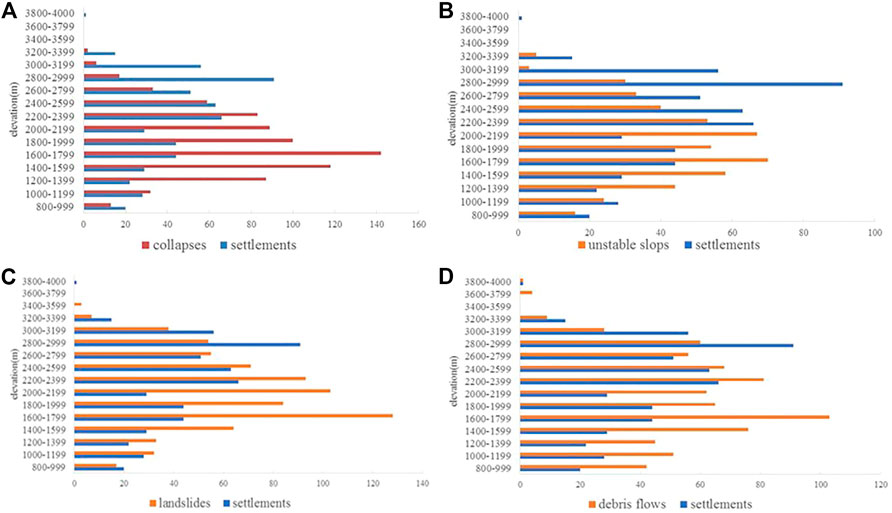
FIGURE 7. The distribution of collapses (A), unstable slopes (B), landslides (C) and debris flows (D) with settlements by elevation in the upper reaches of the Min River.
Correlation analysis showed that there was a weak correlation between the number of settlements and collapses (r = 0.278, p = 0.297), an apparent correlation between the number of settlements and landslides (r = 0.604, p = 0.013), a moderate correlation between unstable slopes and settlements (r = 0.442, p = 0.086), and an apparent correlation between debris flows and settlements (r = 0.663, p = 0.005).
Discussion
Material Basis and Space for Cultivated Land and Settlements
Valley settlement is the most important settlement form in the upper reaches of the Min River (Ding et al., 2018). Deep “V"-shaped erosion small catchments are well developed in this area (Ding et al., 2014). Unstable slopes, collapses, and landslides change landforms, especially topographic slope, which provides relatively flat space for agricultural production and settlements. The rock and soil on a slope may lose stability, breaking away from the parent body under the action of gravity, collapses, and rolls. They accumulate at the foot of the slope (or valley), or the rock and soil slide downward along the slope caused by natural factors such as rainfall, river scouring, earthquakes, snow melting, and rainstorms. The flood flow with a large number of solid substances (such as mud, sand, and stones), brought by water sources such as ice/snow meltwater or dam releases, forms a relatively deep soil layer attractive for cultivation (Cui, 2011).
In the past, under a small-scale peasant economy in the period of traditional agricultural society, people were self-sufficient, and the land was the most basic and important resource (Zhou et al., 2020), and agricultural production mainly depended on cultivated land in mountainous areas, and the scale of settlements is closely related to the quality and quantity of arable land (Ding et al., 2014).
To facilitate farming and basic life activities, settlements were distributed according to intercepted water and soil flow (Ding et al., 2014). The contact zone between a mountain and plain, or the contact zone between a hillside and alluvial fan, often supported rural settlements. To minimize the occupation of cultivated land, the site selection of Tibetan and Qiang settlements was along the mountain. Houses were built close to small and medium-sized streams with good water quality or with convenient places for water intake (Zhou et al., 2020). Many rural settlements often chose relatively stable diluvial, colluvial, or alluvial fans, and relatively wide and slow ice erosion valley areas, which increases the potential risk from geohazards.
Human Production and Well-Being Affected and Caused by Geohazards
Human production and life are threatened by geohazards. When a settlement is located in a collapse area, the front edge of the landslide with the passing area and accumulation area of debris flow will lead to casualties and damage to buildings (Ding and Hu, 2020). Roads and bridges are vulnerable to collapses, landslides, and debris flow, resulting in road obstruction and damage; arable land also will be damaged.
Unreasonable human activities are one of the main factors inducing geohazards (Ding and Hu, 2020). The reconstruction of the slope in the mountainous area of the upper reaches of the Min River by excavating ore resources, and building roads, houses, and other engineering projects have rendered the slope unstable and the environment is damaged. Even if measures, such as artificial tree planting, are taken to restore the environment, the control of rock and soil stability is low and water and soil loss continue (Ding and Hu, 2020). Further, human activities such as reservoir water storage, channel leakage, stacking of waste, slag filling, and strong mechanical vibrations will lead to slope instability and rock and soil movement. This can result in the destruction of cultivated land and houses, as well as casualties, furthermore, landslides and rock collapses produce loose materials, which become the source of rock debris in the affected areas (Cui et al., 2011). The material in the river valley is easily washed away and transformed into debris flow during a rainstorm. Therefore, the relationship among geohazards, settlements and cultivated land is “hazards appear with human being”.
However, different types of geohazards have different effects on people’s production and life. Collapse occurs suddenly, and can pose a fatal threat to life and property, and the accumulation formed by large slope is poor sorting, which is difficult to cultivate. The formation of landslide is slow, with the rock and soil movement being an integrity, which does not destroy the basic soil structure, and even can effectively slow down the slope, which can increase the farming area. Debris flow mainly occurs at the bottom of river channels or gullies, with relatively concentrated scope and little impact on farming areas, which mainly affects human settlements built along rivers or gullies. However, the debris flow is relatively easier to warn than disasters caused by collapse. Unstable slope is mainly due to its unpredictability, which increases the utilization risk.
The Settlement Types Based on Coupling Mechanisms
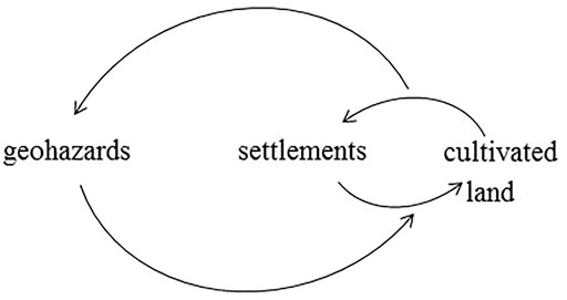
The coupling mechanism of geohazards, settlements, and cultivated land is shown in Figure 8. Geohazards change local landforms, provide materials, and open space for the development of cultivated land and settlements. In the traditional self-sufficient subsistence agriculture stage, there is an interdependent relationship between production space and living space. Yet, human activities, such as reservoir creation, irrigation, deforestation, and slope planting, as well as building houses, roads, and bridges, induce geohazards.
The main function of settlements is supporting life activities, whereas the main function of cultivated land is production. According to the different nature of geohazards, settlements can be categorized into production-stressed settlements and life-stressed settlements. A production-stressed settlement means that the cultivated land maintaining the production function of the settlement is damaged or has the potential risk of damage by geohazards. A life-stressed settlement means that the settlement itself is (or can be) affected by geohazards.
Impacts of Geohazards on Sustainable Development of Mountainous Villages
The Wenchuan earthquake on 12 May 2008, destroyed the stability of mountains in the fault zone and triggered collapses, landslides, barrier lakes (“earthquake lakes”), debris flow, and unstable slopes (Cui et al., 2011); The Wenchuan earthquake on 12 May 2008, had similar effects and further affected the weathering of regional rock mass via faults and folds in subsequent aftershocks. The earthquakes exacerbated the instability of the slope (Cui et al., 2011; Ding and Hu, 2020), and landslides and rock collapses produce loose materials which are sources of rock debris of debris flow in the affected areas (Cui et al., 2011). The chain effects of geohazards made the stresses on local settlements long-lasting (Cui et al., 2011; Zhang et al., 2011).
China has entered the middle stage of industrialization. The impacts on rural areas have been exacerbated by impacts of urbanization and industrialization, and the social and economic structure has been transformed. China has transformed from a rural society to an industrial and urban society, from a closed and semi-closed society to an open society, and from a single homogeneous society to a diversified society (Lu, 1997). The economy has changed from self-sufficient livelihoods to a market-oriented commodity economy (Liu, 2007). With the development of China’s economy, lifestyles are increasingly urbanized, and there is more demand for unaltered environments. Rural areas are no longer just described as remote, backward places in urgent need of modernization (Woods, 2019). Many functions and values possessed by rural areas can relieve excessive pressure on urban systems.
The upper reaches of the Min River are in the historical ethnic corridor and the channel connecting Qiang and Tibet between Han and Tibet. It is a transitional area of Han, Qiang, and Tibetan culture (Wu et al., 2003). With urbanization, the number and scale of cities and towns in this region have increased rapidly, and the relationship between man and land is symbiotic and fed each other in many directions. Under the background of the construction of ecological civilization (Pan, 2016) and the promotion to building beautiful countryside, the priority development of agriculture and rural areas is not only to make up for the rural shortcomings of building a well-off society in an all-round way but also a major task to realize the great rejuvenation of the Chinese nation (Pan, 2016), and the development of mountain society is the top priority of rural revitalization, facing the opportunity of transformation and development.
With the implementation of the two-wheel-drive strategy of new-type urbanization and rural revitalization, the change of the human social and economic systems will cause changes in the human-land relationship in the upper reaches of the Min River. New-type Urbanization Plan (2014–2020) was put forward by China’s National Development and Reform Commission to refine the existing mode of urbanization and promote the citizenization of transferring agricultural residents (Wang et al., 2015), which means more and more peasants will engage in non-agricultural industries. Rural revitalization strategy aimed to achieve high standards for living, rural civilization, clean and tidy villages, and democratic management (Wang and Zhuo, 2018), which pays more attention to the sustainable development of rural areas and the improvement of farmers’ living standards. Settlement is the spatial form of human survival and residence in mountainous areas, which is the most closely connected space-time unit between human beings and the mountainous environment (Ding et al., 2014). The settlements in the upper reaches of the Min River are the product of local people’s long-term adaption to the mountainous environment and have unique cultural value. With the rapid development of transportation, the economy and society of mountain settlements are undergoing development driven by a series of external factors (Zhou et al., 2013). The unique culture and beautiful mountain scenery have attracted many tourists and promoted the development of mountain tourism. With the increasing development of mountain tourism, the protection of cultural resources has received more attention (Chen et al., 2011). In this context, the effect of geohazards on the transformation and development of settlements is vital to understand. Biodiversity, the sensitivity of ecological environments, the human and environment relationship, and the security and livability of settlements should be considered in the urbanization process.
Conclusion
1) There is a coupling mechanism among geohazards, settlements, and cultivated land. According to the nature of geohazards, settlements can be categorized into production-stressed and life-stressed.
2) The impact of geohazards on settlements is lasting and the safety for life-stressed settlements is of great importance.
3) The “two-wheel-drive” strategy of new urbanization and rural revitalization provides opportunities for rural development in mountainous areas and also changes the role of land in human-land relationships, which promotes the change in the focus of community-based disaster risk management.
4) The basis of community-based disaster risk management is to evaluate the risk degree of geohazards to the settlements and to promote optimal utilization of natural environment assets.
Data Availability Statement
The datasets presented in this article are not readily available due to privacy restrictions. Requests to access the datasets should be directed to eWFuZmVuX2xpbHlAMTYzLmNvbQ==.
Author Contributions
MD provide the general idea of the paper, YH Wrote this article, KL analysis the relationship among settlements, cultivated land and ML made correlation analysis.
Funding
This work was funded by the National Natural Science Foundation of China (Grant No. 41871174). The Second Tibetan Plateau Scientific Expedition and Research Program (STEP) (Grant No. 2019QZKK0902).
Conflict of Interest
The authors declare that the research was conducted in the absence of any commercial or financial relationships that could be construed as a potential conflict of interest.
Publisher’s Note
All claims expressed in this article are solely those of the authors and do not necessarily represent those of their affiliated organizations, or those of the publisher, the editors and the reviewers. Any product that may be evaluated in this article, or claim that may be made by its manufacturer, is not guaranteed or endorsed by the publisher.
Acknowledgments
We thank the reviewer and editor, whose constructive comments substantially improved this manuscript.
References
Ahmed, B., Sammonds, P., Saville, N. M., Le Masson, V., Suri, K., Bhat, G. M., et al. (2019). Indigenous Mountain People's Risk Perception to Environmental Hazards in Border Conflict Areas. Int. J. Disaster Risk Reduction 35, 101063. doi:10.1016/j.ijdrr.2019.01.002
Armstrong, M. J. (2000). Back to the Future: Charting the Course for Project Impact. Nat. Hazards Rev. 1, 138–144. doi:10.1061/(asce)1527-6988(2000)1:3(138)
Chen, R., and Cui, P. (2013). Current Situation and prospect of Community-Based Disaster Risk Management (In Chinese). J. Catastrophol. 28, 133–138.
Chen, W., Zhang, P., Zhang, X., Deng, W., Yang, Z., Xue, J., et al. (2011). The Research Progress on Typical Areas in China. Prog. Geogr. 30 (12), 1538–1547. (in Chinese). doi:10.11820/dlkxjz.2011.12.011
Cui, P., Chen, X.-Q., Zhu, Y.-Y., Su, F.-H., Wei, F.-Q., Han, Y.-S., et al. (2011). The Wenchuan Earthquake (May 12, 2008), Sichuan Province, China, and Resulting Geohazards. Nat. Hazards 56, 19–36. doi:10.1007/s11069-009-9392-1
Cui, P. (2011). Formation Mechanism and Risk Control of Mountain Disasters Caused by Wenchuan Earthquake. Beijing: Science Press.
Dalu, M. T. B., Shackleton, C. M., and Dalu, T. (2018). Influence of Land Cover, Proximity to Streams and Household Topographical Location on Flooding Impact in Informal Settlements in the Eastern Cape, South Africa. Int. J. Disaster Risk Reduction 28, 481–490. doi:10.1016/j.ijdrr.2017.12.009
Ding, M.-t., Cheng, Z.-l., and Wang, Q. (2014). Coupling Mechanism of Rural Settlements and Mountain Disasters in the Upper Reaches of Min River. J. Mt. Sci. 11 (1), 66–72. doi:10.1007/s11629-012-2366-x
Ding, M., Heiser, M., Hübl, J., and Fuchs, S. (2016). Regional Vulnerability Assessment for Debris Flows in China-a CWS Approach. Landslides 13 (3), 537–550. doi:10.1007/s10346-015-0578-1
Ding, M., and Hu, K. (2020). Debris Flow hazard Risk Analysis and Settlement Disaster Reduction -- a Case Study of the Upper Reaches of Min River. Beijing: Science Press. (In Chinese).
Ding, M., Miao, C., and Huang, T. (2018). On Characteristics and Evolution Analysis of valley Settlement in the Upper Reaches of Min River. J. Southwest China Normal Univ. (Natural Sci. Edition) 43 (08), 37–43. (in Chinese). doi:10.13718/j.cnki.xsxb.2018.08.008
Fei, X. (2015). Community-based Waterlogging Disaster Risk Analysis and Management-A Case Study of Jingqiao Town, Jiading District of Shanghai, Master. Shanghai, China: Shanghai Normal University. (In Chinese).
Gao, Y. (2013). Community Based Disaster Risk Management- a Case Study of Dijiatai Community, Baiyin City, Gansu Province, Master. Lanzhou, Gansu, China: Lanzhou University. (In Chinese).
Holmes, J. (2006). Impulses towards a Multifunctional Transition in Rural Australia: Gaps in the Research Agenda. J. Rural Stud. 22 (2), 142–160. doi:10.1016/j.jrurstud.2005.08.006
Hossain, M. A. (2013). Community Participation in Disaster Management: Role of Social Work to Enhance Participation. J. Anthropol. 9, 159–171.
Huang, L., and Long, E. (2015). Architecture and Planning Design Strategy of Post-disaster Temporary Settlement with High Building Density--Analysis Based on the Questionnaire in Dujiangyan after Wenchuan Earthquake. Proced. Eng. 121, 101–106. doi:10.1016/j.proeng.2015.08.1028
Ikeda, S., Sato, T., and Fukuzono, T. (2008). Towards an Integrated Management Framework for Emerging Disaster Risks in Japan. Nat. Hazards. 44, 267–280. doi:10.1007/s11069-007-9124-3
Klein, R. J. T., Nicholls, R. J., and Thomalla, F. (20042003). Resilience to Natural Hazards: How Useful Is This Concept. Environ. Hazards 5, 35–45. doi:10.1016/j.hazards.2004.02.001
Li, Y. (2011). Urban‐rural Interaction in China: Historic Scenario and Assessment. China Agric. Econ. Rev. 3 (3), 335–349. doi:10.1108/17561371111165770
Li, Y., Westlund, H., and Liu, Y. (2019). Why Some Rural Areas Decline while Some Others Not: An Overview of Rural Evolution in the World. J. Rural Stud. 68, 135–143. doi:10.1016/j.jrurstud.2019.03.003
Liu, H., Zhang, D., Wei, Q., and Guo, Z. (2017). Comparison Study on Two post-earthquake Rehabilitation and Reconstruction Modes in China. Int. J. Disaster Risk Reduction 23, 109–118. doi:10.1016/j.ijdrr.2017.04.016
Liu, Y. (2007). Rural Transformation Development and New Countryside Construction in Eastern Coastal Area of China. Acta Geographica Sinica 62 (06), 563–570. doi:10.11821/xb200706001
Liu, Y., Wang, Q., Liao, Y., and Du, J. (2018). Ecotourism Development Model in the Upper Reaches of Min River from the Sustainable Livelihood Standpoint View. Tourism Res. 10 (2), 37–49. doi:10.3969/j.issn.1674-5841.2018.02.004
Liu, Z. (2010). The Research on Prevention and Mitigation System for Normality Disaster in Ethnic Minority Region. MasterChangsha, Hunan, China: Central South University. (In Chinese). doi:10.13885/j.issn.1000-2804.2010.02.009
Long, Y., and Zhuang, T. (2009). Status Analysis of Villagers’ Autonomous Organization Participating in Reconstruction after Earthquake-A Case of Sichuan Disastrous Area. J. Hebei Agric. Sci. 13129-132. (In Chinese), 129–132.
Mimaki, J., Takeuchi, Y., and Shaw, R. (2009). The Role of Community-Based Organization in the Promotion of Disaster Preparedness at the Community Level: a Case Study of a Coastal Town in the Kochi Prefecture of the Shikoku Region, Japan. J. Coast Conserv. 13, 207–215. doi:10.1007/s11852-009-0065-8
Pan, J. (2016). China's Environmental Governing and Ecological Civilization. Beijing: China Social Sciences Press and Springer-Verlag GmbH. doi:10.1007/978-3-662-47429-7
Paton, D., Smith, L., and Violanti, J. (2000). Disaster Response: Risk, Vulnerability and Resilience. Disaster Prev. Manag. 9, 173–180. doi:10.1108/09653560010335068
Peng, Y., Zhu, X., Zhang, F., Huang, L., Xue, J., and Xu, Y. (2018). Farmers' Risk Perception of Concentrated Rural Settlement Development after the 5.12 Sichuan Earthquake. Habitat Int. 71, 169–176. doi:10.1016/j.habitatint.2017.11.008
Sha, Y., and Liu, H. (2010). US Disaster Relief Community Construction and its Effect on Chinese Emergency Management. J. Lanzhou Univ. 38, 72–79. (In Chinese). doi:10.13885/j.issn.1000-2804.2010.02.009
Tiwari, A. (2015). “From Capability Trap to Effective Disaster Risk Management Capacity: what Can Governments, Communities, and Donors Do,” in The Capacity Crisis in Disaster Risk Management. Editor A. Tiwari (Cham: Environmental Hazards Springer International Publishing Switzerland), 201–207. doi:10.1007/978-3-319-09405-2_8
Twigg, J. (1999). The Age of Accountability?: Future Community Involvement in Disaster Reduction. Aust. J. Emerg. Manag. 14, 51–58.
United Nations Office for Disaster Risk Reduction (2005). Hyogo Framework for Action 2005-2015: Building the Resilience of Nations and Communities to Disasters. Available at: http://www.unisdr.org/2005/wcdr/intergover/official-doc/L-docs/.
Utami, S., and Bisri, M.SoemarnoSurjono (2014). Disaster Risk and Adaptation of Settlement along the River Brantas in the Context of Sustainable Development, Malang, Indonesia. Proced. Environ. Sci. 20, 602–611. doi:10.1016/j.proenv.2014.03.073
Wang, H., and Zhuo, Y. (2018). The Necessary Way for the Development of China's Rural Areas in the new era-rural Revitalization Strategy. Open Journal of Social Sciences 06, 97–106. doi:10.4236/jss.2018.66010
Wang, X.-R., Hui, E. C.-M., Choguill, C., and Jia, S.-H. (2015). The New Urbanization Policy in China: Which Way Forward? Habitat Int. 47, 279–284. doi:10.1016/j.habitatint.2015.02.001
Wu, N., Yan, Z., Luo, P., and Liu, J. (2003). Acculturation and Diversity of Ethnic Cultures on the Upper Minjiang River. J. Mountain Sci. Z1 (01), 16–23. (in Chinese). doi:10.16089/j.cnki.1008-2786.2003.01.003
Wu, Y. (2015). Coping Capacities of in Ethnic Minority Communities in Anthropology (Beijing, China: MinZu University of China). Ph.D.thesis(in Chinese).
Xia, J. (2010). A Study on Evaluation System of Community Disaster Risk (Shanghai, China: Fudan University). Shanghai, M.S. Thesis(In Chinese).
Xu, Y., Qiu, X., Yang, X., Lu, X., and Chen, G. (2020). Disaster Risk Management Models for Rural Relocation Communities of Mountainous Southwestern China under the Stress of Geological Disasters. Int. J. Disaster Risk Reduction 50, 101697. doi:10.1016/j.ijdrr.2020.101697
Yang, Y., and Zhao, F. (2009). A Survey of Farmers’ Livelihood Capital in the Framework of the Sustainable Livelihood Approach: A Case Study of the Reservoir Zone of the South-To-North Water Transfer (Middle Line) Project. Issues Agric. Economy (3), 58–65. doi:10.13246/j.cnki.iae.2009.03.010
Yin, J., Yi, Z., Wang, J., Xu, S., and Chen, Z. (2009). GIS-based Disaster Risk Assessment of the Urban Community Rainstorm Waterlogging, Geogr. Geo. Inf. Sci. 25, 92–95. (In Chinese).
Zhang, J. (2013). A Study of Disaster Management in Rural Community of Minority Regions with Multiple Subjects’ Participation-Based on the Investigation in South West Region, Master. Yaan, Sichuan, China: Sichuan Agricultural University. (In Chinese).
Zhang, L., Zhang, Y., and Gaon, X. (2002). Geological hazard Economics. Shijiazhuang: Hebei Peoples Publishing House. (In Chinese).
Zhang, T., Zhou, A., Feng, X., and Tian, F. (2011). “Analysis on the Law of Geological Disaster Chain of "5 · 12" Wenchuan Earthquake —Taking an County as an Example,” in Proceedings of 2011 National Academic Conference on Engineering Geology (Beijing: Science Press). (In Chinese).
Zhou, G., He, Y., Tang, C., Yu, T., Xiao, G., and Zhong, T. (2013). Dynamic Mechanism and Present Situation of Rural Settlement Evolution in China. J. Geographical Sci. 23 (03), 513–524. doi:10.1007/s11442-013-1025-7
Zhou, L., Huang, X., and Zhang, L. (2020). Geography, Settlement and Space: Environment Perception and Landscape Adaptation of the Qiang Ethnic Group in Northwest Sichuan. J. Aba Teach. Univ. 37 (04), 12–19. (In Chinese).
Keywords: rural settlements, geohazards, mountains, transition period, the upper reaches of Min river, natural resources, spatial scale, sustainable development
Citation: He Y, Ding M, Liu K and Lei M (2022) The Impact of Geohazards on Sustainable Development of Rural Mountain Areas in the Upper Reaches of the Min River. Front. Earth Sci. 10:862544. doi: 10.3389/feart.2022.862544
Received: 26 January 2022; Accepted: 25 February 2022;
Published: 23 March 2022.
Edited by:
Haijun Qiu, Northwest University, ChinaReviewed by:
Xuefeng Yuan, Chang’an University, ChinaShujun Tian, Southwest University of Science and Technology, China
Copyright © 2022 He, Ding, Liu and Lei. This is an open-access article distributed under the terms of the Creative Commons Attribution License (CC BY). The use, distribution or reproduction in other forums is permitted, provided the original author(s) and the copyright owner(s) are credited and that the original publication in this journal is cited, in accordance with accepted academic practice. No use, distribution or reproduction is permitted which does not comply with these terms.
*Correspondence: Mingtao Ding, bWluZ3Rhb2RpbmdAMTYzLmNvbQ==
 Yanfen He1,2
 Mingtao Ding
