
95% of researchers rate our articles as excellent or good
Learn more about the work of our research integrity team to safeguard the quality of each article we publish.
Find out more
ORIGINAL RESEARCH article
Front. Earth Sci. , 18 March 2022
Sec. Structural Geology and Tectonics
Volume 10 - 2022 | https://doi.org/10.3389/feart.2022.856321
This article is part of the Research Topic Advances in the Study of Natural Fractures in Deep and Unconventional Reservoirs View all 29 articles
 Zhang Bowei*
 Fu Guang
Favorable oil and gas channels during fault activity and cease episodes were determined to understand oil and gas distribution in reservoirs of “lower generation, upper accumulation”-type near faults in petroliferous basins through identifying and coupling conduit systems and hydrocarbon expulsion distribution during these periods, respectively. It was used to establish a method to identify the evolution patterns of favorable oil–gas charging positions at source fault configurations, which was applied to understand the evolution of favorable oil and gas channels in the middle and lower Es-3 sub-member in the southwest of the Jiuzhou fault. The results show that the conduit pattern in the Es-3 sub-member is mainly distributed in the center, west, and east of the F1 fault and the eastern part of the F7 fault in the southwest of the Jiuzhou fault. The conduit to non-conduit pattern is mainly distributed in the middle and center of the F7 fault. The non-conduit to conduit pattern is mainly distributed in the west and east of the F1 fault and the east of the F7 fault. The non-conduit is mainly distributed in the middle and east of the F7 fault. The conduit pattern and conduit to non-conduit pattern in the middle and lower Es-3 sub-member are favorable for hydrocarbon migration and accumulation. It is consistent with the oil and gas discovered in the middle and lower Es-3 sub-member near the southwest of the Jiuzhou fault, indicating that this method is feasible to identify the favorable oil and gas channels at source fault configurations.
The oil and gas exploration practices show that oil-source faults play an important role in controlling the reservoir of “lower generation, upper accumulation” type in petroliferous basins, while some sub-units of faults have no occurrence of oil and gas migration (Tong-wen et al., 2014; Xinlei and Guang, 2014; Yanfang et al., 2014; Bowei et al., 2017; Fu and Wang, 2018; Guang et al., 2018). Hence, the development of favorable conduit systems at source fault configurations is one of the important elements to govern oil and gas accumulation and distribution. Accurately identifying the evolution patterns of favorable conduit systems at source fault configurations is important to deeply understand oil and gas distribution near oil-source faults in petroliferous basins and guide oil and gas exploration.
Considerable research studies have been performed on the favorable positions of source fault configurations for oil and gas migration. In terms of favorable parts during fault activity episodes, previous researchers believed that they were primarily located within hydrocarbon expulsion from source rocks (Xiaolong et al., 2017; Xinhuai et al., 2009; Tongwen et al., 2012; Xinbing et al., 2012; Gui-pu et al., 2017; Fu et al., 2021). Currently, research studies on favorable positions during fault cease episodes are mainly based on the spatial coupling of convex ridge and hydrocarbon expulsion (Hao-ran, 2016; Junqiao et al., 2017; Jianmin et al., 2019; Junpei et al., 2020). The earlier results play a significant role in correctly understanding the distribution law of oil and gas near oil-source faults in petroliferous basins.
However, our limited understanding and research approaches only allow us to separately identify favorable positions during fault activity and cease episodes. Currently, the evolution patterns of conduit systems and their identification methods are poorly investigated because of some problems. These problems make current research studies difficult to accurately predict oil and gas distribution near oil-source faults and bring risks to oil and gas exploration. Therefore, identifying the evolution patterns of favorable conduit systems at source fault configurations is of great significance for correctly understanding oil and gas distribution near oil-source faults.
Oil-source faults can migrate oil and gas during activity periods because they not only connect source rocks and target intervals but also remain open during oil and gas charging. More importantly, its associated fractures have relatively high porosity and permeability compared with matrix rocks, which are the dominant channels for oil and gas migration. Therefore, oil-source-associated fractures within hydrocarbon expulsion are the favorable positions for oil and gas accumulation during fault activity periods (Figure 1A). Associated fractures are tightly closed due to the overlying sedimentary load and regional pressure during fault cease episodes, losing their ability to migrate oil and gas. However, these fractures are commonly filled, where only positions with relatively high porosity and permeability can be used as oil and gas channels. The porosity and permeability of fractures primarily vary with the shale content, decreasing with the increasing shale content. It can be concluded that the favorable positions for oil and gas migration during fault cease episodes are the lowly filled positions within hydrocarbon expulsion (Figure 1B).
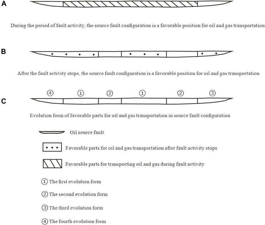
FIGURE 1. Schematic diagram of evolution form of favorable position for transporting oil and gas with source-fault configuration.
Four main evolution patterns of favorable oil and gas channels at source fault configuration are concluded via coupling favorable conduit systems during fault activity and cease episodes. The first is the conduit pattern, that is, the source fault configuration is completely favorable for oil and gas migration during fault activity and cease episodes, which is most conducive to oil and gas migration and accumulation (① in Figure 1C). The second is the conduit to non-conduit pattern, that is, the source fault configuration is favorable for migrating oil and gas during the fault activity period, while it is negative for oil and gas migration during fault cease episodes. This pattern can be contributive to oil and gas migration and accumulation (② in Figure 1C). The third is the non-conduit to conduit pattern, where source fault configuration is not favorable for oil and gas migration during the fault activity period, but it is favorable for oil and gas charging during the fault cease period. This pattern is not conducive to oil and gas migration and accumulation (③ in Figure 1C). The last one is the non-conduit pattern, where source fault configuration is not favorable for migrating oil and gas during fault activity and cease periods, which is most unfavorable for oil and gas migration and accumulation (④ in Figure 1C).
Determining favorable positions for oil and gas migration during fault activity and cease episodes are essential to identify their evolution patterns. Favorable positions of conduit systems and distribution of hydrocarbon expulsion during fault activity episodes are necessary to be determined, since their coupling positions are favorable for oil and gas migration during this period.
In this study, current displacements of oil-source faults at target intervals are acquired using three-dimensional seismic data. Ancient displacements during fault active periods are restored using the maximum fault distance subtraction method, and then they are divided by active periods to obtain the ancient activity rate (Roman et al., 1998; Rongcai et al., 2003). Figure 2 shows the relationship between the determined paleoactivity rate of oil-source faults at known well points and their nearby oil and gas shows. The minimum paleoactivity rate at the oil and gas display is selected as the minimum value required for oil and gas migration along oil-source faults, because their associated fractures can only migrate oil and gas into reservoirs, developing oil and gas pools, when the paleoactivity rate is higher than the minimum value (Guang et al., 2018). The favorable conduit systems during fault active periods can be determined with paleoactivity rates determined previously and the minimum activity rate required for oil and gas migration (Figure 3A). Hydrocarbon expulsion threshold of the source rock can be determined by the method proposed by Xiongqi et al. (2004), and the distribution of expelled hydrocarbon can be determined based on the relationship between the thermal maturity of the source rock and buried depth (Figure 3B). Consequently, the favorable positions for oil and gas migration during the fault activity period can be identified by superimposing favorable conduit systems and hydrocarbon expulsion distribution (Figure 3C).
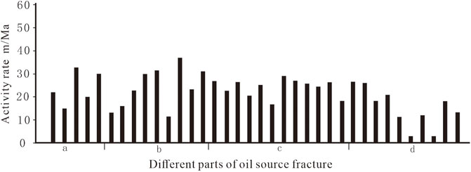
FIGURE 2. Schematic diagram of determining favorable positions for oil source faults to transport oil and gas in active period.
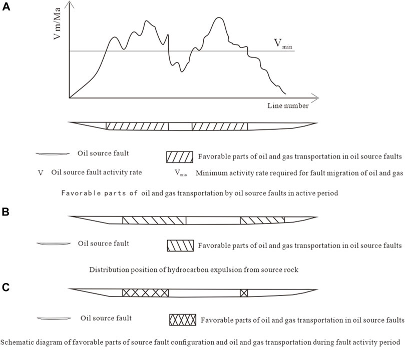
FIGURE 3. Schematic diagram of determining favorable positions for transporting oil and gas by source-fault configuration during fault active period.
Similarly, favorable conduit systems and hydrocarbon expulsion distribution during fault cease episodes should be determined and superimposed to identify favorable oil and gas channels at the source fault configuration during these periods. The shale content of the fault filler at different positions can be calculated using Eq. 1 (Figure 4), while oil-source fault displacements in target reservoirs, interval thickness, and shale content can be acquired using drilling and seismic data. The relationship between the shale content of filling at oil-source faults and nearby oil and gas shows in the study area is statistically analyzed in this study. The minimum shale content is assumed as the maximum value required for conduit systems, which can allow oil and gas to migrate into the reservoir. Comparing the determined shale content in the oil-source fault filler with the maximum value, we can identify the favorable positions of oil-source faults to migrate oil and gas during fault cease periods (Figure 4). Favorable oil and gas migration positions during fault cease periods can be figured out by superimposing the identified favorable positions with hydrocarbon expulsion distribution (Figure 5).
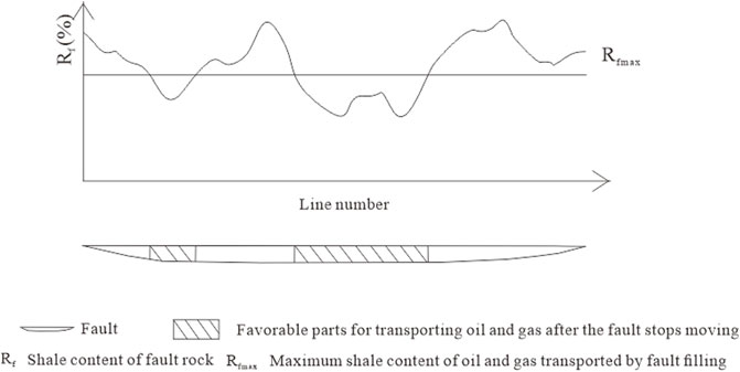
FIGURE 4. Schematic diagram of determining the favorable position for oil source fault to transport oil and gas after stopping activity.
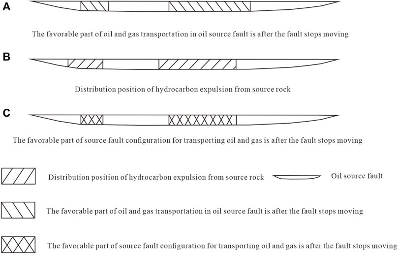
FIGURE 5. Schematic diagram of determining the favorable position of the source fault configuration to transport oil and gas after the fault ceases to be active.
where Rf is the shale content of fractured rock, %; Hi is the thickness of certain fractured strata, m; Ri is the shale content of certain fractured strata, %; n, the number of fractured strata; and L, the fault displacement, m.
Consequently, the evolution pattern of oil and gas channels at source fault configuration can be identified by superimposing the determined favorable positions during fault activity and cease episodes (Figure 1C).
The middle and lower Sha-3 sub-member at the southwest of the Jiuzhou fault in the Daliuquan area in the Bohai Bay Basin are employed as an example to identify the evolution patterns of favorable oil and gas channels in the source fault configurations. The oil and gas discovered in the middle and lower Sha-3 sub-member in the southwest of the Jiuzhou fault is used to verify the feasibility of the method.
The Daliuquan area in the middle of Langgu sag is an important oil and gas exploration target. The Paleogene is mainly filled by the Kongdian Formation, Shahejie Formation, and Dongying Formation. The Neogene mainly includes the Guantao Formation and Minghuazhen Formation, with thin quaternary sequences. Currently, oil and gas are mainly discovered in the middle and lower Sha-3 sub-member, which was mainly derived from the underlying Sha-4 member. Hence, it is regarded as a typical “lower generation, upper accumulation”-type reservoir. The Jiuzhou fault in the middle of the Daliuquan area is an NNE-trending normal fault, which is composed of F1 and F7 faults in the southwest (Figure 6). It is a large-scale fault extending from the Sha-4 member to the bottom of the Guantao Formation, which connects the Sha-4 source rock and the middle and lower Sha-3 sub-member in the southwest. It was active during oil and gas expulsion in the Sha-2 period, acting as oil-source faults for the middle and lower Sha-3 sub-member (Junqiao, 2018). Figure 6 shows that oil and gas discovered in the middle and lower Sha-3 sub-member near the southwest of the Jiuzhou fault is mainly distributed in the west and east of the F7 fault as well as in the center of the F1 fault. Consequently, the evolution of favorable oil and gas channels at source fault configurations is critical for the oil and gas distribution, and it is important to accurately identify the evolution patterns of these favorable channels in the middle and lower Sha-3 sub-member near the southwest of the Jiuzhou fault.
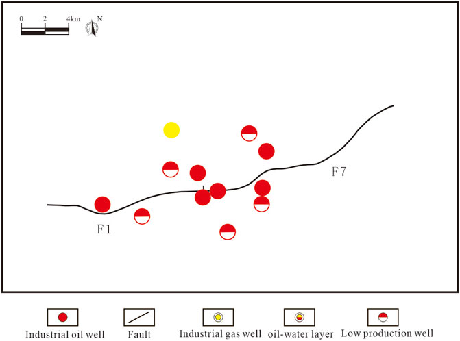
FIGURE 6. Petroleum distribution relationship between the southwest of Jiuzhou fault and the middle and lower sub-member of Es3.
3D seismic data are used in this study to acquire current displacement at the southwest of the Jiuzhou fault in the middle and lower Sha-3 sub-member. Figure 7A shows that the middle-west and east of the F7 fault and the east of the F1 fault have relatively large ancient displacements. The cross plot of the paleoactivity rate of oil-source faults in the middle and lower Sha-3 sub-member and oil and gas shows in the Daliuquan area (Figure 8A) suggests that the minimum activity rate required to migrate oil and gas is about 10 m/Ma, which can be used to identify favorable positions for oil and gas migration. Figure 9A shows that the favorable conduits at the southwest of the Jiuzhou fault are primarily developed in the middle-west and east of the F7 fault and the east of the F1 fault.
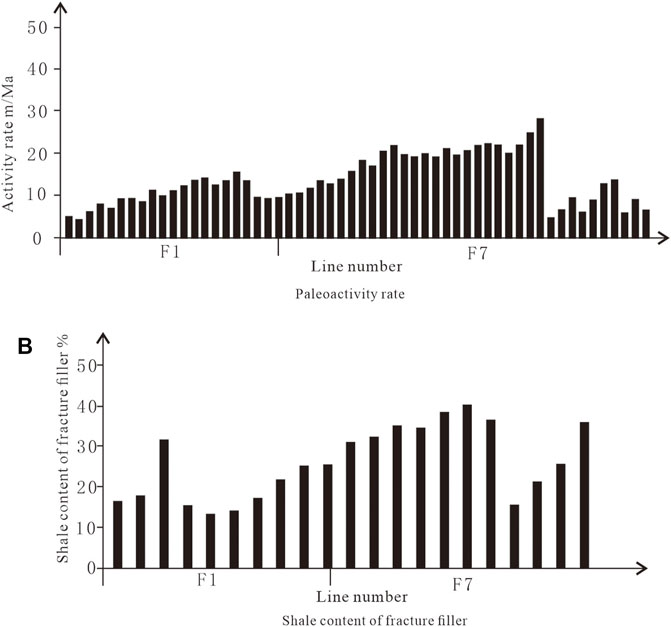
FIGURE 7. In the southwest part of the Jiuzhou fault, the internal source fault is configured to transport oil and gas in the middle and lower sub-member of Es3.
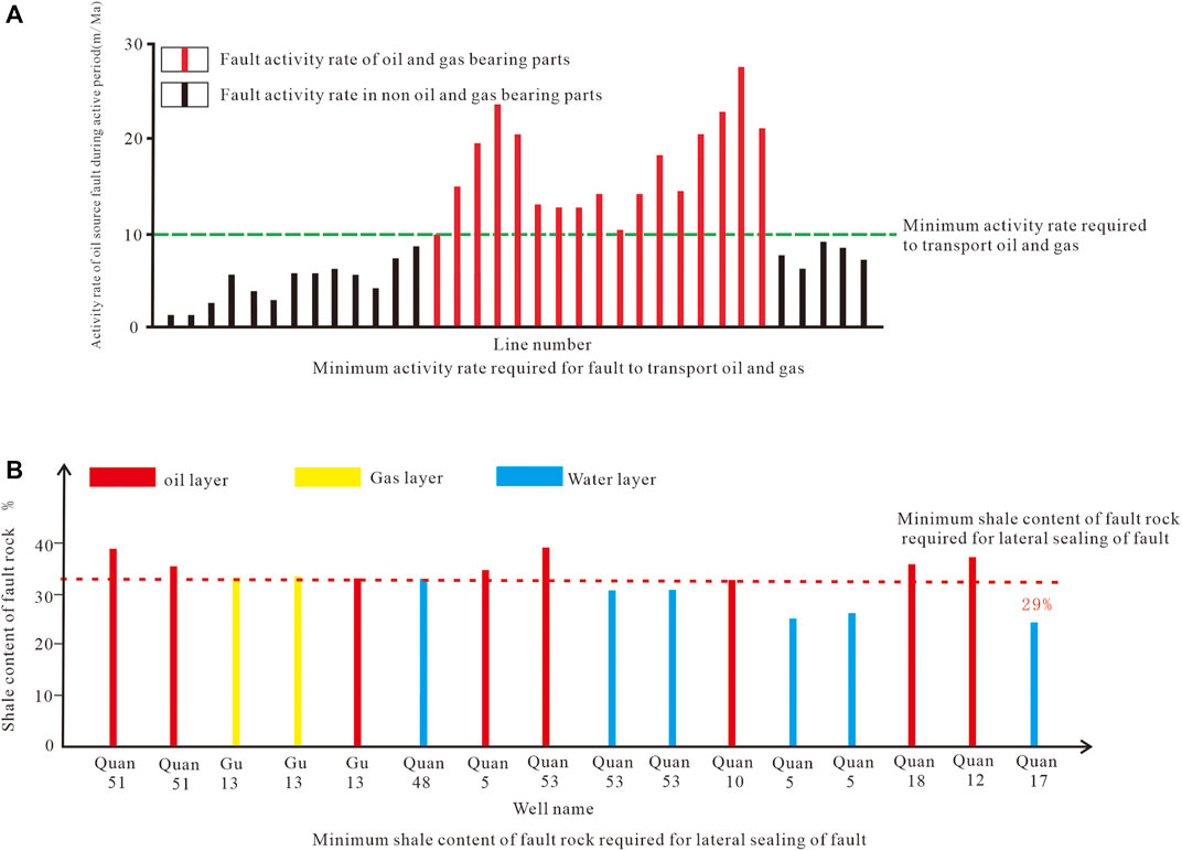
FIGURE 8. Determination of lower limit for oil and gas transportation of faults in Daliuquan area in the middle and lower sub-member of Es3.
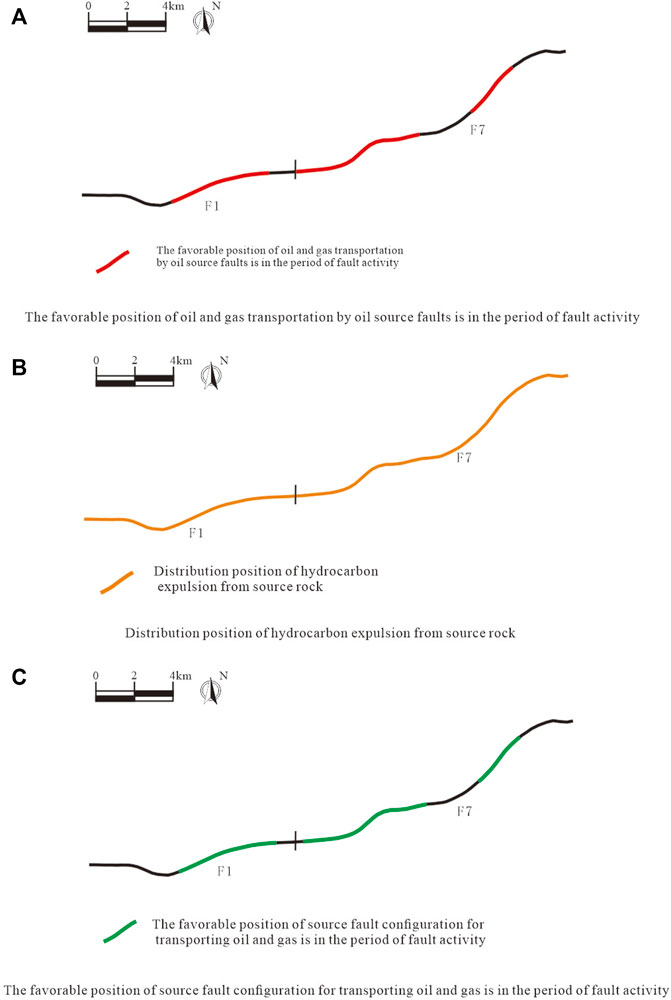
FIGURE 9. The mapping of the favorable position of the source and fault configuration for transporting oil and gas in the southwest of the Jiuzhou fault in the middle and lower sub-member of Es3 during fault activity period.
The hydrocarbon expulsion threshold determination suggests that the hydrocarbon expulsion of the Sha-4 source rocks occurred at about 3,280 m in the Daliuquan area, and expelled hydrocarbon from the Sha-4 source rock was mainly distributed in the southwest of the Jiuzhou fault (Figure 9B). The favorable channels determined earlier are superimposed with the hydrocarbon expulsion distribution to identify favorable positions for oil and gas migration during the fault activity period, where the middle and lower Sha-3 sub-member was located at the favorable position (Figure 9C), distributed in the middle-west and east of the F7 fault and the middle and east of the F1 fault.
The drilling and seismic data are used to acquire displacements in the middle and lower Sha-3 sub-member in the southwest of the Jiuzhou fault, interval thickness, and shale content. Shale contents of filling in the middle and lower Sha-3 sub-member in the southwest of the Jiuzhou fault are calculated using Eq. 1. Figure 7B shows that the shale content is relatively high in the center and west of the F7 fault and the east and west of the F1 fault. The minimum shale content (Figure 8B) required for sealing in the middle and lower Sha-3 sub-member is about 29%. Therefore, the favorable positions for oil and gas migration in the lower middle Sha-3 sub-member in the southwest of the Jiuzhou fault during fault cease periods can be identified. Figure 10A shows that the favorable parts for oil and gas migrations during fault cease periods were mainly distributed in the east of the F7 fault and the F1 fault.
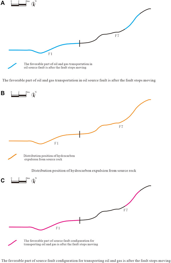
FIGURE 10. The map of the favorable position of the source and fault configuration for transporting oil and gas in the southwest of the Jiuzhou fault after the fault ceases to be active in the middle and lower sub-member of Es3.
The favorable oil and gas channels in the middle and lower Sha-3 sub-member during fault cease periods are superimposed with the distribution of hydrocarbon expulsion in the southwest of the Jiuzhou fault, which was located in the east of the F7 fault and the F1 fault (Figure 10B). The evolution pattern of favorable conduits at source fault configurations can be identified through combining these channels during fault active periods and cease periods. The conduit pattern in source fault configuration is mainly distributed in the east of the F7 fault and the center, west, and east of the F1 fault (① in Figure 11). The second pattern is mainly distributed in the middle-west and center of the F7 fault (② in Figure 11). The third pattern is mainly distributed in the east of the F7 fault and the west and east of the F1 fault (③ in Figure 11). The fourth pattern is mainly distributed in the middle and east of the F7 fault (④ in Figure 11).
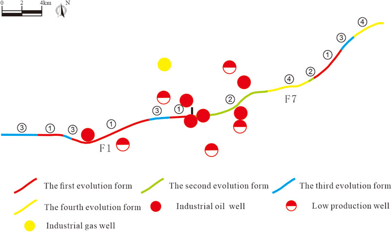
FIGURE 11. The evolution pattern and oil and gas distribution diagram of the favorable position for transporting oil and gas in the inner source fault configuration in the lower member of the middle and lower sub-member of Es3 in the southwest of Jiuzhou fault.
The oil and gas generated by the Es-4 source rocks migrated and accumulated at the middle and lower Es-3 sub-member via the first and second evolution patterns during fault activity periods, which can well explain the oil and gas discovered in the middle-west of the F7 fault and the middle-west of the F1 fault (Figure 11).
(1) The evolution patterns of favorable oil and gas channels at source fault configurations refer to the coupling of conduit systems at source fault configurations during fault activity and cease periods. It can be divided into four patterns. The first, the conduit pattern, is defined as favorable conduit systems during both fault active periods and cease periods, which is most conducive to oil and gas migration and accumulation. The second is the conduit to non-conduit pattern, where the source fault configurations are a favorable oil and gas channels during the fault activity period, but is negative for oil and gas migration during fault cease periods, which can contribute to oil and gas migration and accumulation. The third pattern is the non-conduit to conduit pattern, where source fault configuration cannot act as the oil and gas migration channel during fault activity periods, but can contribute to oil and gas migration during fault cease periods, which also can make contribution to oil and gas migration and accumulation. The fourth is the non-conduit pattern during fault activity and cease periods, which is unfavorable for oil and gas migration and accumulation.
(2) Favorable conduit systems and the hydrocarbon expulsion distribution during fault active and cease periods are determined to identify favorable positions for oil and gas migration, respectively. Consequently, the identification method of favorable channel evolution at source fault configurations is established, whose feasibility is confirmed by the application.
(3) The conduit pattern in the middle and lower Sha-3 sub-member in the southwest of the Jiuzhou fault in the Daliuquan area, Bohai Bay Basin, is mainly distributed in the east of the F7 fault and the center, west, and east of the F1 fault. It was positive for the migration of oil and gas from the Es-4 source rock to the middle and lower Es-3 sub-member. The conduit to non-conduit pattern is mainly distributed in the center and west of the F7 fault, which could contribute to the oil and gas migration and accumulation. The non-conduit to conduit pattern is mainly distributed in the eastern part of the F7 fault and the western and eastern parts of the F1 fault, which was negative for oil and gas migration and accumulation. The non-conduit pattern is mainly distributed in the middle and eastern terminals of the F7 fault, which was unfavorable for the oil and gas migration and accumulation. The results are consistent with oil and gas discovered near the southwest of the Jiuzhou fault.
(4) The earlier identification method can be applicable to identify the evolution patterns of favorable channels for hydrocarbon pools of “lower generation, upper accumulation” type in petroliferous basins.
The raw data supporting the conclusion of this article will be made available by the authors, without undue reservation.
ZB presented the idea and design of the research. ZB wrote the manuscript and led the data analysis and interpreted the results with FG. All authors contributed to the original article revision and approved it for publication.
This work was supported by the National Natural Science Foundation of China (No. 42002140) and the Natural Science Foundation of Heilongjiang Province (No. LH2019D005).
Author ZB and FG are employed by Northeast Petroleum University.
The remaining authors declare that the research was conducted in the absence of any commercial or financial relationships that could be construed as a potential conflict of interest
All claims expressed in this article are solely those of the authors and do not necessarily represent those of their affiliated organizations, or those of the publisher, the editors, and the reviewers. Any product that may be evaluated in this article, or claim that may be made by its manufacturer, is not guaranteed or endorsed by the publisher.
The authors gratefully acknowledge the Science and Technology Innovation Team in Heilongjiang Province. The research topic of this team is “Oil and gas accumulation and preservation.”
Bowei, Z., Guang, F., and Juhe, Z. (2017). Fracture Development in Oil-Migrating Fault Transition Zones and its Control on Hydrocarbon Migration and Accumulation: A Case Study of Es 2Oil Formation of Yilunpu Structure of Wen'an Slope of Jizhong Depression[J]. J. Jilin University(Earth Sci. Edition) 47, 370–381. doi:10.13278/jcnki.jjuese.201702104
Fu, G., Liang, M., Guo, H., and Han, X. U. (2021). A Prediction Method of Favorable Positions of Transporting Oil and Gas Capacity Configuration in Different Periods of Faults[J]. Nat. Gas Geosci. 32 (1), 28–37. doi:10.1016/j.jnggs.2021.05.002
Fu, G., and Wang, H. (2018). Determination Method and its Application of Favorable Positions for Hydrocarbon Transport in Oil-Source Fault during Different Periods[J]. Acta Petrolei Sinica 39 (2), 180–188. doi:10.7623/syxb201802006
Guang, F. U., Dailei, S., and Haoran, W. (2018). The Effect of Fault Reactivation on the Sealing of Mudstone Caprocks Based on Seismic Data[J]. Geophys. Prospecting Pet. 57 (3), 478–485. doi:10.7623/syxb201802006
Gui-pu, J., Guang, F. U., and Tong-wen, S. (2017). Seismic Data Is Used to Determine the Transportation Oil-Gas Ability of Oil Source Faults and the Difference of Oil-Gas Accumulation[J]. Prog. Geophys. 32 (1), 160–166. doi:10.6038/pg20170122
Hao-ran, W., Guang, F., and Tong-wen, S. (2016). Recovery of Oil-Source Fault Ancient Transfer Zone and its Favorable Conditions to Oil-Gas transportation:Taking Fault F10 in No.2 Structure of Nanpu Sag as an Example[J]. Nat. Gas Geosci. 27, 1848–1854. doi:10.11764/j.issn.1672-1926.2016.10.1848
Jianmin, L. I., Dunshan, M. U., and Qiaoqiao, L. I. (2019). Comprehensive Prediction Method of Favorable Parts for Oil and Gas Transmission in Oil Source Faults and its Application[J]. J. Xi'an Shiyou University(Natural Science) 34 (6), 14–19. doi:10.3969/j.issn.1673-064X.2019.06.003
Junpei, Y., Xiaobo, H., Pengbo, L., Yu, X., and Chuanchao, Y. (2020). Fault Characterization and Reservoir Forming Under Control Of"Source-Fault-Trap":A Case Of the Boundary Faults in the Southern Part Of Miaoxinan Uplift[J]. Mar. Geology. Front. 36, 32–38. doi:10.16028/j.1009-2722.2020.031
Junqiao, L. (2018). Prediction Method and Application of Dominant Transporting Pathway for Fault[J]. J. Guangdong Univ. Petrochemical Tech. 28 (4), 10–15. doi:10.1016/j.jnggs.2021.05.002
Junqiao, L., Tong, Z., and Tongwen, S. (2017). Controlling Effect of Conducting Capacity of Oil Source Faults on Oil and Gas Distribution[J]. Spec. Oil Gas Reservoirs 24 (5), 27–31. doi:10.3969/j.issn.1006-6535.2017.05.005
Roman, M. G., Hart, B. S., Nelson, S., Flemings, P. B., and Trudgill, B. D. (1998). Three-dimensional Geometry and Evolution of a Salt-Related Growth-Fault Array: Eugene Island 330 Field, Offshore Louisiana Gulf of Mexico[J]. Mar. Pet. Geology. 15, 309–328. doi:10.1016/S0264-8172(98)00021-X
Rongcai, Z., Jun, P., and Hongcan, G. (2003). Analysis Of Fracture Active Stages, Heat Fluid Nature and the Process Of Forming Reservoir In Western Sichuan Sag[J]. J. Chengdu Univ. Tech. 30, 551–558.
Tong-wen, S., Guang, F. U., Yan-fang, L. V., and Hu, M. (2014). Main Controlling Factors on the Hydrocarbon Accumulation in the Middle-Shallow Layer of 1st Structure, Nanpu Sag[J]. Nat. Gas Geosci. 25, 1042–1051. doi:10.11764/j.issn.1672-1926.2014.07.1042
Tongwen, S., Guang, F. U., Yanfan, L. U., and Rong, Z. (2012). A Discussion on Fault Conduit Fluid Mechanism and Fault Conduit Form[J]. Geol. Rev. 58, 1081–1090. doi:10.16509/j.georeview.2012.06.005
Xiaolong, X., Youlu, J., and Hongliang, W. (2017). Lanliao Faulting Activities and Their Control over Sedimentation in the Dongpu-Xinxian Sag[J]. Spec. Oil Gas Reservoirs 24, 16–21. doi:10.3969/j.issn.1006-6535.2017.01.004
Xinbing, Z., Huayao, Z., and Changyu, T. (2012). Controlling of Hydrocarbons by Neotectonics and Tectonics Fault activities.a Case Study of Bozhong Area[J]. J. China Univ. Mining Tech. 41, 452–459.
Xinhuai, Z., Chengmin, N., and Changyu, T. (2009). Relationship between Faulting and Hydrocarbon Pooling during the Neotectonic Movement Around the central Bohai Bay[J]. OIL GAS GEOLOGY. 30, 469–475. doi:10.1016/S1876-3804(19)60229-6
Xinlei, H., and Guang, F. (2014). Control of Fault Connecting Source Rock and Reservoir on Lower Generation and Upper Storage Pattern Oil-Gas Accumulation and distribution:Taking Middle-Shallow Area of Nanpu Depression as an Example[J]. Fault-Block Oil and Gas Field 21 (3), 273–277. doi:10.1016/S1876-3804(08)60090-7
Xiongqi, P., Sumei, L., and Zhijun, J. (2004). Geochemical Evidences of Hydrocarbon Expulsion Threshold and its Application[J]. Earth Science-Journal China Univ. Geosciences 29 (4), 384–390.
Keywords: source fault configuration, conducting oil and gas, favorable channels, evolution pattern, identification method
Citation: Bowei Z and Guang F (2022) Identification Method of Evolution Patterns of Favorable Oil and Gas Channels at Source Fault Configuration and Its Application. Front. Earth Sci. 10:856321. doi: 10.3389/feart.2022.856321
Received: 17 January 2022; Accepted: 14 February 2022;
Published: 18 March 2022.
Edited by:
Wei Ju, China University of Mining and Technology, ChinaReviewed by:
Wenjie Feng, Yangtze University, ChinaCopyright © 2022 Bowei and Guang. This is an open-access article distributed under the terms of the Creative Commons Attribution License (CC BY). The use, distribution or reproduction in other forums is permitted, provided the original author(s) and the copyright owner(s) are credited and that the original publication in this journal is cited, in accordance with accepted academic practice. No use, distribution or reproduction is permitted which does not comply with these terms.
*Correspondence: Zhang Bowei, ODU3NjAyMzA1QHFxLmNvbQ==
Disclaimer: All claims expressed in this article are solely those of the authors and do not necessarily represent those of their affiliated organizations, or those of the publisher, the editors and the reviewers. Any product that may be evaluated in this article or claim that may be made by its manufacturer is not guaranteed or endorsed by the publisher.
Research integrity at Frontiers

Learn more about the work of our research integrity team to safeguard the quality of each article we publish.