 Bryan J. Marfito
 Deo Carlo E. Llamas
 Mario A. Aurelio
94% of researchers rate our articles as excellent or good
Learn more about the work of our research integrity team to safeguard the quality of each article we publish.
Find out more
ORIGINAL RESEARCH article
Front. Earth Sci. , 03 March 2022
Sec. Structural Geology and Tectonics
Volume 10 - 2022 | https://doi.org/10.3389/feart.2022.799803
On 10 February 2017, a MS 6.7 earthquake, whose epicenter was located in Surigao Strait, struck the province of Surigao del Norte, causing numerous geologic impacts and damages to infrastructure. Field investigation conducted immediately after the earthquake revealed an NNW-SSE-striking surface rupture that extends 4.1 km inland. The remaining 20 km of the surface rupture, based on the computed magnitude-surface rupture length empirical relationship, was inferred to be located offshore along the Philippine Fault in Surigao Strait. We investigated the geometry of the fault in Surigao Strait by identifying morphotectonic features and geologic structures using offshore geophysical data that include multibeam bathymetry, sub-bottom profiles, and seismic reflection profiles. We interpreted several fault-related features such as pull-apart basin, offset channels, linear valleys, and folds and identified four fault segments, which are named the Maka-andog Strand, Surigao-Sanghid Strand, West Sanghid Strand, and Panaon Strand. Based on fault length, these segments are capable of generating MW 6.4 to 6.9 earthquakes. We have determined that surface rupture most probably extends along the entire length of the Surigao-Saghid Strand that generated the 2017 MS 6.7 earthquake. The identified morphotectonic features, presence of strike-slip with significant normal displacement in offshore geophysical imaging data, and focal mechanism all suggest that Philippine Fault in Surigao Strait is dominated by transtensional deformation, which supports the interpretations by previous authors.
Earthquakes in the Philippines are generated by the movements of active faults and trenches which bound and straddle the archipelago. Between 1988 and 2003, major earthquakes in the Philippines claimed 1,385 lives and cost approximately PhP34.94 billion worth of damages to private and public infrastructures and properties (World Bank, 2005). One such major earthquake generator is the Philippine Fault, which is a left-lateral active fault traversing Northern Luzon southward to Eastern Mindanao (Allen, 1962; Morante, 1974; Hirano et al., 1986; Quebral et al., 1996; Aurelio et al., 1997b; Tsutsumi and Perez, 2013; Perez et al., 2015; Rimando and Rimando, 2020). The Philippine Fault and other major faults in the Philippines accommodate the trench parallel slip component of the oblique convergence of the Philippine Sea Plate (PSP) and the Sunda Plate (SP) with the Philippine Mobile Belt (PMB) (also known as the shear partitioning (Fitch, 1972; Pinet and Cobbold, 1992; Aurelio, 2000) or the complex shear partitioning (Rimando et al., 2020; Rimando et al., 2019)).
Studies of the offshore extensions of the Philippine Fault were conducted previously on its northern offshore extension in West Luzon (Armada et al., 2012); on the offshore extension south of the Guinayangan segment (Yasuda et al., 2015); on the central offshore segments of the Philippine Fault in Masbate Bay, Sibuyan Sea, Leyte Gulf, and Surigao Strait (Bischke et al., 1990; Aurelio et al., 1991, Aurelio et al., 1997a; Aurelio et al., 1997b); and the offshore extension of the Mati segment in Pujada Bay (Pubellier et al., 1999). However, most of these previous offshore fault studies are concentrated on the structural characteristics of these offshore faults as opposed to determining their geomorphic characteristics. Additionally, offshore active faults could impact offshore and onshore; they are often overlooked due to the lack of offshore geophysical data in the majority of the offshore areas surrounding the Philippines. The high investment cost of offshore geophysical and geological equipment inhibits the widescale gathering of offshore data.
On 10 February 2017, an earthquake with a surface wave magnitude (MS) of 6.7 struck the province of Surigao del Norte. Based on seismicity data, the earthquake was located in the vicinity of Surigao Strait with a depth of 10 km. Immediately after the earthquake, a field investigation was conducted to map the geologic impacts generated by the earthquake such as ground rupture, liquefaction, landslides, and damages to properties and infrastructures (DOST-PHIVOLCS, 2018). The fault that generated the earthquake is believed to be the offshore extension of the Philippine Fault, Surigao Segment, in Surigao Strait, based on the hypocentral location, focal mechanism, and fault maps generated by previous works (Quebral et al., 1996; Aurelio et al., 1997a; DOST-PHIVOLCS, 2019b). To determine the location, geometry, and segmentation of the fault that generated the earthquake, offshore fault mapping was conducted in Surigao Strait. Morphotectonic and structural features of faulting were identified from various offshore geophysical datasets such as high-resolution multichannel bathymetry, sub-bottom profiles, and seismic reflection profiles.
Surigao Strait is situated within the PMB, an island arc composed of pre-Cretaceous to Cretaceous ophiolitic basement, Paleocene to Miocene sedimentary rocks, Miocene to Pliocene volcanic rocks, Eocene to Oligocene intrusive rocks, and Pliocene to Pleistocene clastic sedimentary and volcanic rocks (MGB, 2010; Aurelio et al., 2013). The PMB is bounded by two opposite-dipping plates which are the Sunda Plate and the Philippine Sea Plate. The Sunda Plate, located west of the PMB, is being subducted along the Manila Trench, Negros-Sulu Trench, and the Cotabato Trench (Hayes and Lewis, 1984; Lewis and Hayes, 1984; Hayes and Lewis, 1985; Armada et al., 2012). The Philippine Sea Plate, located east of the PMB, is being subducted along the Philippine Trench (Hamilton, 1979; Lewis and Hayes, 1983; Lallemand et al., 1998; Lagmay et al., 2009).
Surigao Strait is bounded by southern Leyte on the north and northeastern Mindanao on the south (Figure 1). The geology of southern Leyte is composed of Cretaceous to Paleogene igneous rocks, Late Oligocene to Early Miocene volcanic rocks, Late Miocene to Early Pliocene volcanic and sedimentary rocks, Late Pliocene sedimentary rocks, and Late Pliocene to recent volcanic rocks. The geology of southern Leyte is part of the Central Highland stratigraphic unit (MGB, 2010). The geology of northeastern Mindanao is composed of Cretaceous ophiolitic rocks, Late Cretaceous metamorphic rocks, Late Eocene sedimentary rocks, Late Oligocene to Early Miocene clastic sedimentary and volcanic rocks, Oligocene intrusive rocks, Middle Miocene carbonates, Late Miocene to Late Pliocene clastic sedimentary rocks, Late Pliocene volcanic and intrusive rocks, and Pleistocene clastic sedimentary rocks. The geology of northeastern Mindanao is part of the Northern Pacific Cordillera stratigraphic unit (MGB, 2010).
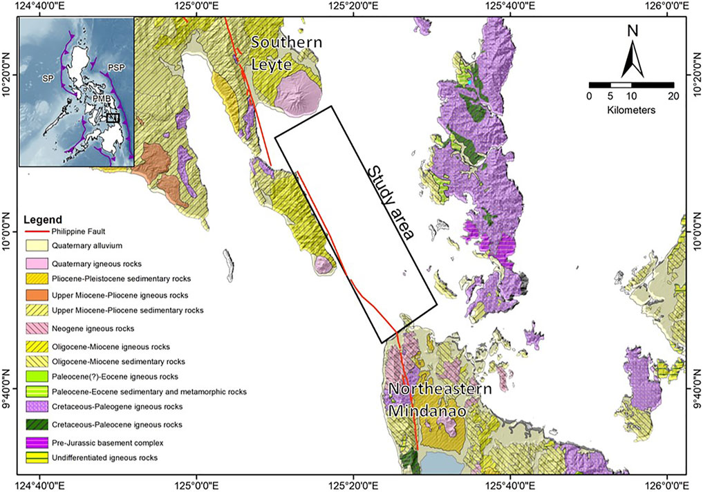
FIGURE 1. Inland geologic map surrounding the study area showing the geology of southern Leyte and northeastern Mindanao. The geology of southern Leyte is part of the Central Highland stratigraphic unit, while the geology of northeastern Mindanao is part of the Northern Pacific Cordillera stratigraphic unit (MGB, 2010).
The Philippine Fault is an approximately 1,400–1,600 km-long fault (Rimando and Knuepfer, 2006; Rimando and Rimando, 2020) that traverses Northern and Central Luzon, Infanta in Quezon province, Polillo Strait, Lamon Bay, Guinayangan and Calauag in Quezon province, Ragay Gulf, Masbate Island, Masbate-Naro Bay Pass, Leyte Island, Surigao Strait, Surigao provinces, Agusan provinces, Davao de Oro, Davao del Norte, and Davao Oriental (Allen, 1962; Quebral et al., 1996; Aurelio et al., 1997b; Tsutsumi and Perez, 2013; Perez et al., 2015; Tsutsumi et al., 2015; Rimando and Rimando, 2020). The fault is generally striking NNW-SSE to NW-SE with a major left-lateral component and a dip-slip component. Formation of the Philippine Fault is known to be synchronous with the Philippine Trench through the process of shear partitioning (Fitch, 1972; Pinet and Cobbold, 1992; Aurelio, 2000).
In Eastern Mindanao, the Philippine Fault is divided into ten geometric segments (Figure 2A). Geometric segmentation is based on the presence of discontinuities such as fault stepovers, gaps, bends, and separations which divide the faults into different segments. Meanwhile, earthquake rupture segmentation is based on segments of the fault that have ruptured during an earthquake, which may involve one or more geometric segments (Schwartz and Sibson, 1989; DePolo et al., 1991). The ten geometric segments of the Philippine Fault in Eastern Mindanao are the (1) Surigao Segment, (2) Lianga Segment, (3) Esperanza Segment, (4) Agusan Marsh Segment, (5) West Compostela Valley Segment, (6) Central Compostela Valley Segment, (7) Nabunturan Segment, (8) East Compostela Valley Segment, (9) Caraga River Segment, and (10) Mati Segment (Quebral et al., 1996; Perez et al., 2015; DOST-PHIVOLCS, 2019a). The fault extends further offshore from Pujada Bay to the Molucca Sea as interpreted from the bathymetric data and seismic profiles (Pubellier et al., 1999). Morphotectonic features associated with the fault in Eastern Mindanao are fault scarps, offset streams, linear depression, en-echelon cracks, transected young alluvial fans, sag ponds, and pressure ridges (Perez et al., 2015). The presence of left-lateral slickensides on outcrops, Quaternary normal faulting on seismic profiles, and strike-slip focal mechanism is also associated with the Philippine Fault (Quebral et al., 1996). The fault is also known to have transected folded belts and pull-apart basins, which suggests that this fault formed after the formation of folds and basins (Pubellier et al., 1991; Quebral et al., 1996). One of the segments of the Philippine Fault in Eastern Mindanao is the Surigao Segment, which was known to have generated the 1879 Mw 7.4 Surigao earthquake (Bautista and Oike, 2000; Perez and Tsutsumi, 2017).
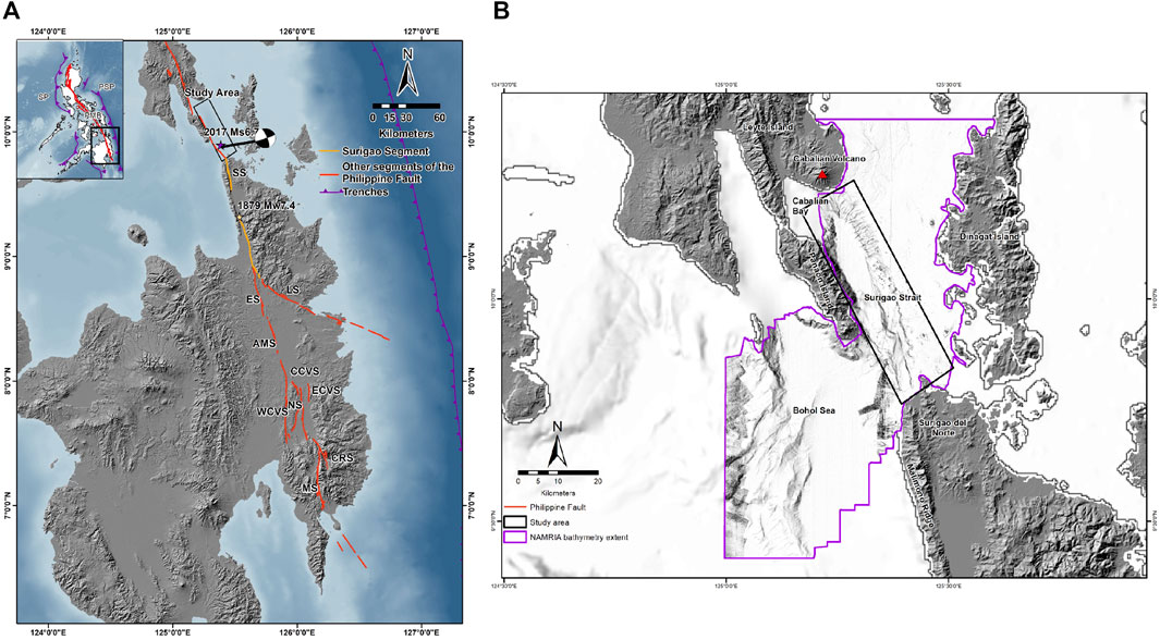
FIGURE 2. (A) Ten (10) segments of the Philippine Fault in Eastern Mindanao according to Perez et al. (2015) and DOST-PHIVOLCS (2019b). These are the SS, Surigao Segment (orange polyline); LS, Lianga Segment; ES, Esperanza Segment; AMS, Agusan Marsh Segment; WCV, West Compostela Valley Segment; CCVS, Central Compostela Valley Segment; NS, Nabunturan Segment; ECVS, East Compostela Valley Segment; CRS, Caraga River Segment; and MS, Mati Segment. Stars indicate the location of damaging earthquakes in Surigao from the study of Bautista and Oike (2000). (B) Extent of the bathymetry data provided by NAMRIA in Surigao Strait and the Bohol Sea. Study area: black box.
The Surigao Segment is an approximately 100-km-long NNW-SSE-trending fault that traverses the coast of San Francisco, Surigao del Norte, and the eastern boundary of Malimono Ridge. The fault runs along the coast of Lake Mainit, continues on to Tubay Valley, and ends on the western flats of Eastern Mindanao Ridge (Perez et al., 2015). This fault segment is identified based on morphotectonic features such as en-echelon faults, offset streams, pressure ridges, fault scarps, transected folds, and a large pull-apart basin known as Lake Mainit based on the interpretations of aerial photographs, satellite imageries, and field mapping (Quebral et al., 1996; Perez et al., 2015). The slip rate of the segment derived from Global Navigation Satellite System (GNSS) measurements is approximately 3–5 mm/year (Rangin et al., 1999; Aurelio, 2000) with previous works suggesting GNSS measurement as high as 26 mm/year (Bacolcol et al., 2012). Paleoseismic studies of the fault indicate at least four surface-rupturing events for the past 1,300 years, and one of such events is associated with the 1879 Mw7.4 Surigao earthquake (Bautista and Oike, 2000; Perez and Tsutsumi, 2017). The slip rate of the segment derived from a paleoseismic study is approximately 5–17 mm/year (Perez and Tsutsumi, 2017), which is comparable to GNSS-derived slip rates. The Philippine Fault in Surigao Strait was proposed to have generated the 2017 MS 6.7 Surigao del Norte earthquake. The earthquake was hypothesized to generate a surface rupture offshore, which continued onshore for approximately 4.1 km. The morphotectonic features of the onshore surface rupture are fault scarps, offset markers (e.g., rice paddies and roads), and en-echelon faults (DOST-PHIVOLCS, 2018). The trace of the Philippine Fault in Surigao Strait was previously mapped using seismic reflection profiles and bathymetry data (Aurelio et al., 1997a).
A 5 m × 5 m × 5 m resolution and 100 m × 100 m × 100 m resolution bathymetry data of Surigao Strait provided by the National Mapping and Resource Information Authority (NAMRIA) (Figure 2B) were converted from a netCDF format to GeoTIFF and Band Interleaved by Line (BIL) formats using Geospatial Data Abstraction Library (GDAL/OGR Contributors, 2020). The GeoTIFF file was reprojected from the World Geodetic System 1984 (WGS84) to the World Geodetic System 1984-Universal Transverse Mercator 51oN (WGS84-UTM51N) using the ArcMap 10.5 projection toolbox. The reprojection was made to enable the measurement of fault segment lengths and other morphotectonic features in meters. With the ArcGIS Pro hillshade toolbox, multidirectional hillshade maps were produced using the reprojected bathymetry of Surigao Strait. Additionally, 3D anaglyphs of Surigao Strait were also produced using SimpleDEMViewer (Katayanagi, 2021), which was used to visualize vertical exaggerated maps of Surigao Strait.
Seafloor features in Surigao Strait related to faulting were identified using multidirectional hillshade and 3D anaglyphs (Figures 3–5). These seafloor features are fault scarps, linear ridges, linear valleys, offset streams, and saddles (Wesson et al., 1975; Research Group for Active Faults of Japan, 1991; Tsutsumi and Perez, 2013). Features of fault stepovers such as pull-apart basins and restraining bends were also mapped on the seafloor. The maximum credible magnitude was also calculated based on the length of each segment using the empirical relationship equation of surface rupture length and moment magnitude on a strike-slip fault (Wells and Coppersmith, 1994).
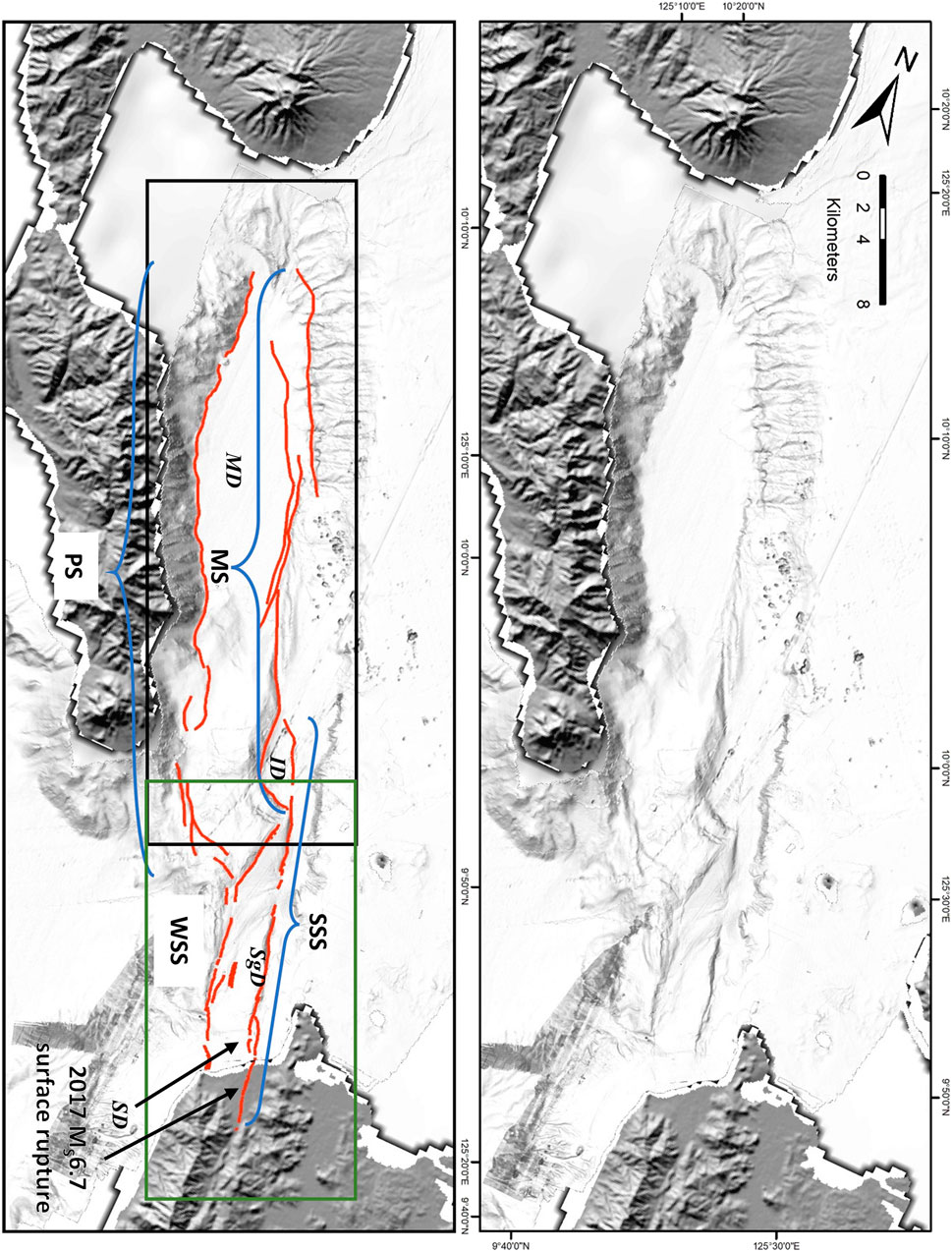
FIGURE 3. Uninterpreted (top) and interpreted (bottom) multidirectional hillshade strip maps showing the seafloor morphology of Surigao Strait. The four segments of the Philippine Fault in Surigao Strait are the MS, Maka-andog Strand; SSS, Surigao-Sanghid Strand; PS, Panaon Strand; and the WSS, West Sanghid Strand. Additionally, pull-apart basins due to fault stepover are also shown on the map. These are the MD, Maka-andog Deep; SgD, Sanghid Deep; ID, Igsabod Deep; and SD, Sario Deep. Zoomed-in versions of the maps are to be shown in Figures 4 (extent in the black box) and 5 (extent in the green box).
The sub-bottom profiles were acquired using two Stratabox 3.5 kHz transducers manufactured by SyQwest Inc. The transducers were mounted laterally on the front side of the boat/marine vessel. The transducers were set to acquire data at 30 dB DC Gain, 0 shift range, and 1,500 m/s sound velocity. The two transducers generated pulses of high-frequency acoustic beams that are sent into the water column. These beams traveled into the water column until they reached the seafloor. Upon reaching the seafloor, these beams were reflected, absorbed, and/or refracted based on the material acoustic properties. The position of the sub-bottom profiles was tracked using a Differential GNSS (DGNSS) NMEA receiver, which was mounted on the roof of the marine vessel. The sub-bottom profiles were viewed in real time using Stratabox v 3.0.8.1. For this study, a total of six survey lines were surveyed with approximately 500-m spacing. The six survey lines were oriented perpendicular to the offshore trace of the fault based on the mapping conducted by Quebral et al. (1996) and Aurelio et al. (1997a). Six sub-bottom profiles from this survey were named SL1, SL2, SL3, SL4, SL5, and SL6 from southeast to northwest, respectively (Figure 6A). The sub-bottom profiles were post-processed using the Chesapeake Technology SonarWiz 7. The following processing methods were applied on the sub-bottom profiles: (1) removal of the water column, (2) isolation of the spectrum related to the acoustic properties of the material to be investigated thru band-pass filter, and (3) increase the amplitude of the attenuated signals on the profile thru the automatic gain control.
The analyses of sub-bottom profiles were complemented by paper-based industry unmigrated seismic reflection profiles acquired in 1975 by Phillips Petroleum, which have greater depth coverage. These profiles were provided by the Department of Energy (DOE). Based on the metadata of the seismic reflection profiles, they were processed in the following order: (1) binary gain recovery, (2) true amplitude gain recovery, (3) common depth point, (4) velocity analysis, (5) deconvolution, (6) normal moveout, (7) muting, (8) common depth point, (9) gapped deconvolution, and (10) digital band-pass filter. Only two out of the five seismic reflection profiles (LG 42 and LG 44-2) given by DOE had traversed the Philippine Fault in Surigao Strait semi-perpendicularly (Figure 7A). The sub-bottom and seismic reflection profiles were used to determine the subsurface geometry of the fault.
PHIVOLCS’ seismicity catalog was used to determine foci of earthquakes from 1897 to 2019 (DOST-PHIVOLCS, 2019c). The range of dates represents the relocated seismicity. Additionally, a list of historical earthquakes by Bautista and Oike (2000) was also incorporated into the seismicity data. A bounding box was generated using a data extraction tool named AWK to only include seismicity data within Surigao Strait. The seismicity data in comma-separated value (CSV) format was converted to shapefile using ArcMap 10.5. The focal mechanisms from the Global Centroid Moment Tensor (GCMT) (Ekström et al., 2012) were sorted using the AWK and ArcMap 10.5. They were plotted using the ArcBeachball toolbox (Tiesheng, 2020). The plotted foci and the focal mechanisms of earthquakes were used to associate earthquakes that are related to the movement of the Philippine Fault or the subduction of the Philippine Sea Plate on the west.
The Philippine Fault in Surigao Strait has a total length of approximately 55 km. The fault traverses the offshore slope along the coast of San Juan, Southern Leyte it continues for 4.1 km inland that ruptured during the 2017 M6.7 earthquake. Then, it connects with the Philippine Fault, Surigao Segment (Figure 3).
The segmentation of the Philippine Fault in Surigao Strait is based on geometric characteristics such as fault stepovers (Wesnousky, 2006; Wesnousky, 2008). Four segments of the Philippine Fault in Surigao Strait were identified based on fault stepovers. These segments are the Maka-andog Strand, the Surigao-Sanghid Strand, the West Sanghid Strand, and the Panaon Strand from northwest to southeast, respectively. Their names were derived from the pull-apart basin they have traversed or the name of the nearest locality onshore.
The Maka-andog Strand is an approximately 34-km-long segment with a general strike of N25°W. In the bathymetry data, this strand starts on an offshore lazy S-shaped pull-apart basin named the Maka-andog Deep located south of the coast of San Juan, Southern Leyte (Figure 4). The strand in this area is manifested by a linear ridge, offset streams, and fault scarp. Two left-lateral offset streams were mapped with a measured cumulative heave of 240 and 540 m, respectively. The mapped west-facing fault scarp has a throw measurement of approximately 327 m. Then, the strand steps over to the right with a separation distance of 2.2 km and an overlap between the two strands of approximately 10 km. The strand is manifested by the presence of a west-facing fault scarp after the step. The strand steps over again to the left with a separation distance of 667 m and an overlap of 9.6 km. The strand on this area is characterized by left-lateral stream offsets and southwest-facing fault scarps. The focal mechanism of earthquakes in this area also indicates left-lateral strike-slip faulting. The strand traversed the remaining 9.8 km of Igsabod Deep. After the strand exits Igsabod Deep, the strand is manifested by a linear valley for 6.5 km with a depth of 68 m. Afterward, the strand continues for the remaining 2.2 km until it terminates on an extensional stepover, creating the Igsabod Deep, with a step of approximately 5.2 km along strike between this strand and the succeeding strand.
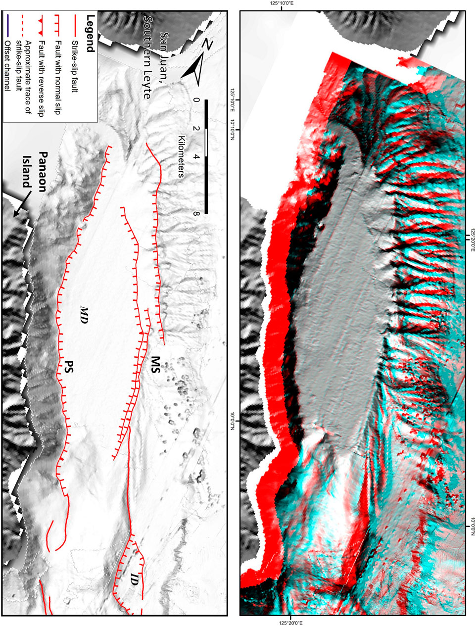
FIGURE 4. 3D anaglyph (top) and multidirectional hillshade (bottom) zoomed-in maps of the black box in Figure 3 showing the morphotectonic features of the Maka-andog (MS) and Panaon Strands (PS). The morphotectonic features such as left-lateral offset streams (blue colored lines) and opposite-facing fault scarps on Maka-andog Deep (MD) indicate the presence of left-lateral fault with normal displacement. The extent of the Maka-andog Strand ends with a stepover which created the Igsabod Deep (ID).
The Surigao-Sanghid Strand is an approximately 26-km-long segment with a general strike of N17°W (Figure 5). In the bathymetry data, this strand starts from the southeast tip of the Igsabod Deep, a 93-m-deep spindle-shaped pull-apart basin generated from the extensional stepover between the Maka-andog Strand and Surigao-Sanghid Strand. The Surigao-Sanghid Strand continues to traverse a linear ridge for 1.1 km. Some traces of the segment are indiscernible since they could probably be covered by mass wasting events. For the next 3 km southeast, the strand exhibits localized transpression due to right-stepping en-echelon faulting which is located in the Sanghid Deep. Seismic profile LG 44-2 shows basin-bounded opposite-dipping faults with normal displacement (Figures 7B,C). These faults coincide with the location of the Sanghid Deep. Further southeast, the strand traverses a linear ridge for 8 km. A plateau is left-laterally offset by this strand by 60 m. The focal mechanism of earthquakes shows strike-slip faulting in this area. One of such earthquakes with a strike-slip focal mechanism is the 2017 MS 6.7 Surigao del Norte earthquake. The strand steps over to the left for 1 km along strike, which creates another pull-apart basin named the Sario Deep. Opposite-facing fault scarps were mapped on the boundary of the Sario Deep. On the northeast transect of the sub-bottom profiles SL1 to SL6, they show a basin bounded by opposite-dipping faults with normal displacement (Figures 6B–E). The location of the faults in Figure 6E coincides with the location of the Sario Deep. Afterward, the strand continues further to the coast of Surigao del Norte where it continues inland for 4.1 km. This trace inland is the mapped surface rupture of the 2017 MS 6.7 Surigao del Norte earthquake (DOST-PHIVOLCS, 2018).
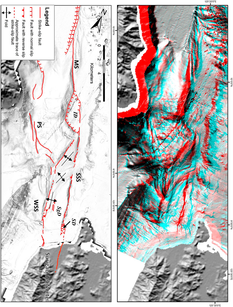
FIGURE 5. 3D anaglyph (top) and multidirectional hillshade (bottom) zoomed-in maps of the green box in Figure 3 showing the morphotectonic features of the Maka-andog Strand (MS), Surigao-Sanghid Strand (SSS), West Sanghid Strand (WSS), and Panaon Strand (PS). Morphotectonic features such as opposite-facing, fault scarps, and pull-apart basins indicate the presence of left-lateral fault with normal displacement. Sanghid Deep (SgD) and Sario Deep (SD) were formed due to left fault stepover.
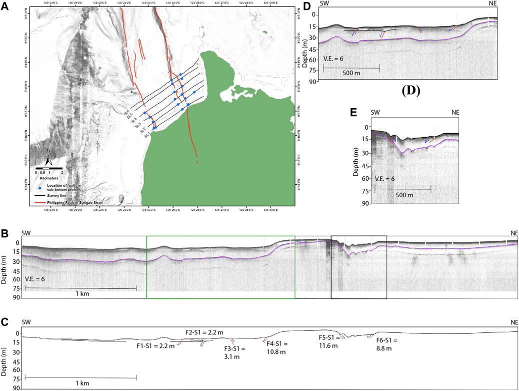
FIGURE 6. (A) Location of the identified faults on sub-bottom profiles SL1 to SL6 relative to the Philippine Fault in Surigao Strait mapped using bathymetry data. (B) Uninterpreted and (C) fault interpreted sub-bottom profile SL1. (D,E) Zoomed-in profiles (green and black box in a) of sub-bottom profile SL1.
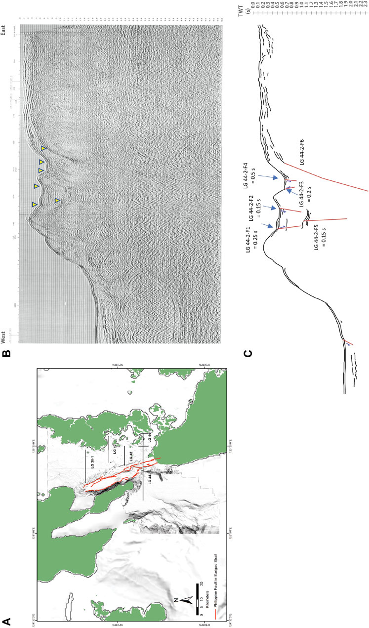
FIGURE 7. (A) Location of the seismic profiles provided by DOE in Surigao Strait. Out of the five seismic profiles, only two of them (LG 42 and LG 44-2) have traversed the study area. (B,C) Uninterpreted and fault-interpreted paper-based seismic reflection profile LG 44-2, respectively. Yellow arrows in (B) are the interpreted faults in (C).
Previous works generated an elastic dislocation model of a single planar fault of the 2017 earthquake (Marfito et al., 2017; Mangahas et al., 2018) using the focal mechanism from PHIVOLCS source parameter determination based on waveform inversion of Fourier transformed seismograms-centroid moment tensor (SWIFT-CMT) (Nakano et al., 2008; Bonita et al., 2015; Punongbayan et al., 2015) and coseismic GNSS-derived velocities. Assuming the fault followed the expected rupture length of 24 km for an MW 6.7 earthquake, the model shows the rupture extent of the 2017 earthquake, which starts from the northwestern tip of the Surigao-Sanghid Strand up to the 4.1-km-long onshore surface rupture of the 2017 earthquake. The 4.1-km-long surface rupture was mapped as a part of the Philippine Fault, Surigao Segment (Tsutsumi et al., 2015; Perez and Tsutsumi, 2017).
The West Sanghid Strand is an approximately 15-km-long segment branching from the Surigao-Sanghid Strand (Figure 5) in the bathymetry data. West Sanghid Strand’s starting trend is N10°E for 4.5 km. Then, the segment rotated counterclockwise, which changed its general trend to N12°W. The rotation formed folds as the maximum principal stress axis (σ1) is now oriented perpendicular towards the West Sanghid Strand. The folds trend NE-SW in the north and NNE-SSW in the south. The size of the folds wanes as the fault’s orientation changes to NW. The segment, located west of the folds, shows faulting on the toe of the landslide deposits. This indicates that a recent surface-rupturing earthquake event occurred on this segment. The segment steps over to the left with a separation distance of 90 m and an overlap of 223 m. The strand continues for 2 km as indicated by east-facing fault scarps and continuous linear features. The segment steps over again but this time to the right, generating a pressure ridge. The separation distance between the two traces is 2 km, with no overlap between them. However, the gap between the traces is between 2.1 and 2.3 km and hence is not classified into a new segment. The trace after the stepover is characterized by right-stepping en-echelon traces. This is also manifested on seismic profile LG 44-2, which occurs as opposite-dipping faults with normal displacement (Figures 7B,C). This en-echelon faulting may indicate the termination of the Philippine Fault in this area or just the termination of the West Sanghid segment, which could connect with the segment of the Philippine Fault in Malimono Ridge as mapped by Quebral et al. (1996).
The Panaon Strand is an N65°W-trending 38 km segment that branched off from the West Sanghid Strand (Figure 5) in the bathymetry data. The trend of the segment changes to N30°W as it heads towards Panaon Island. The strand manifests an almost north- to northeast-facing fault scarp from southeast to northwest, respectively. The northeast trace of this strand could connect onshore east of Panaon Island. Short traces of this segment are also mapped on the eastern offshore of Panaon Island. The traces exhibit a more northerly trend of N13°W. They are manifested by east-facing fault scarps. The Panaon Strand extends further north for 25 km where it acts as the west-bounding fault of the Maka-andog Deep. However, the trace of the segment in this area is approximate due to low data quality.
Based on the mapping done by Quebral et al. (1996) and DOST-PHIVOLCS (2019b), the Philippine Fault in Surigao Strait traversed the Cabalian Bay from the southern coast of the Municipality of Saint Bernard, Leyte (Figure 4). The fault steps to the left as it traverses the eastern offshore slopes of Panaon Island. The fault bends to the southeast towards the tip of Panaon Island. This bend changed the strike of the fault from NNW to NW. The fault connects to the Surigao Segment of the Philippine Fault where it changes its strike from NW to NNW. The fault trace between Panaon Island and the coast of Surigao is mapped based on a lone seismic profile.
In contrast, the active-fault mapping in this study shows that the fault started from the south of the coast of San Juan, Southern Leyte. The fault traverses Surigao Strait southeast where the expression of the fault is manifested as fault scarps, linear valley, linear ridges, offset streams, and boundary faults (Vedder and Wallace, 1970; Sylvester, 1988). These features are consistent with the observed morphotectonic features observed in this area in a study conducted by Aurelio et al. (1997b) and on the Philippine Fault, Surigao Segment, by Perez et al. (2015). The fault bifurcates into East and West Sanghid Strands. The Surigao-Sanghid Strand and its extension southeast connect with the Philippine Fault, Surigao Segment. Meanwhile, the West Sanghid Strand bifurcates, generating a strand that heads northwest to the Panaon Island, while the remaining trace of the West Sanghid Strand either terminates before the coast of Surigao del Norte as manifested by en-echelon faulting or connects with the trace of the Philippine Fault in Malimono Ridge onshore as proposed by Quebral et al. (1996). The trace of the fault is almost the same as that with Aurelio et al. (1997b), which is located from the south of the Sanghid Deep and Panaon Island up to the coast of Surigao del Norte (Figure 8).
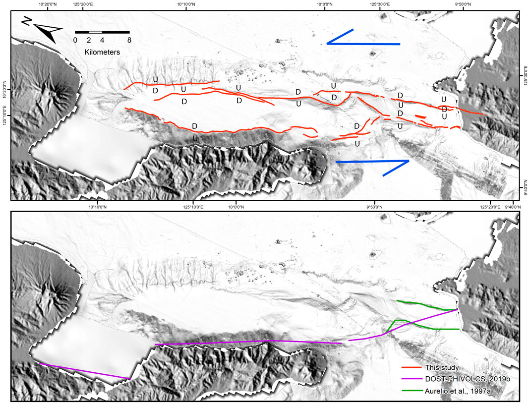
FIGURE 8. Comparison of the traces of the Philippine Fault in Surigao Strait from previous studies (top) by DOST-PHIVOLCS (2019b) and Aurelio et al. (1997a) with this study (bottom).
The connection between the Philippine Fault in Surigao Strait with the known mapped trace of the Philippine Fault in Leyte is difficult to establish since there are no available high-resolution bathymetry data of Cabalian Bay. The presence of strike-slip focal mechanism earthquakes onshore the San Juan, Southern Leyte, segment based on the GCMT catalog suggests an existence of a fault in the area which could connect with the Philippine Fault in Surigao Strait. However, there is a lack of evidence of active faulting possibly due to the young eruptive deposits from Mount Cabalian, which is classified as an active volcano (Delos Reyes et al., 2018; DOST-PHIVOLCS, 2019a), covering the trace of the fault.
The four segments of the Philippine Fault in Surigao Strait, which are the Maka-andog Strand, West Sanghid Strand, and Panaon Strand, are segmentized based on the presence of more than 3–4 km fault stepovers, with the addition of earthquake rupture segmentation for the Surigao-Sanghid Strand. These fault stepovers are manifested as pull-apart basins, which could inhibit fault rupture during an earthquake (Schwartz and Sibson, 1989; Wesnousky, 2006; Wesnousky, 2008). However, some earthquakes could rupture beyond their geometric segments (DePolo et al., 1991; Hamling et al., 2017). The shape of the pull-apart basins is either a spindle or lazy S. The lazy S-shaped pull-apart basin is relatively mature compared to the spindle-shaped basin (Cunningham and Mann, 2007). The Maka-andog and Sanghid Deeps are classified as lazy S-shaped basins, while the Igsabod Deep and Sario Deep are classified as spindle-shaped basins. This suggests that the trace of the fault in Maka-andog and Sanghid Deeps is older or more active than the other traces of the fault. The Maka-andog Deep is bounded by the Panaon Strand and the Maka-andog Strand. These faults are possibly connected at depth and manifest on the shallow subsurface as a negative flower structure (Figure 11). The Sanghid Deep is possibly a result of the left stepover of the Surigao-Sanghid Strand to the West Sanghid Strand. The branching of the West Sanghid Strand and its curvilinear geometry generated the observed folds. The folds are probably produced due to the NE trend of the West Sanghid Strand, oblique/nearly orthogonal to the orientation of σ1. Seismic reflection profiles indicate that the Sanghid Deep is bounded by two sets of opposite-dipping faults with normal displacement. These faults are possibly the traces of the West Sanghid Strand and Surigao-Sanghid Strand, which could be connected at depth and manifest on the shallow subsurface as a negative flower structure same as with the Maka-andog Deep.
The epicenter of the 2017 MS 6.7 Surigao del Norte earthquake is located on Surigao Strait (DOST-PHIVOLCS, 2018). The focal mechanism and mapped surface rupture onshore showed that the earthquake occurred on an NW-SE-trending left-lateral fault with a minor normal slip component (GCMT, 2017; DOST-PHIVOLCS, 2018). Our mapping suggests that the 24-km-long trace of the Surigao-Sanghid Strand is a seismogenic fault. This includes the 20-km-long trace from the south of Igsabod Deep up to the northern coast of Surigao del Norte and the remaining 4.1-km-long onshore surface rupture (DOST-PHIVOLCS, 2018), which is mapped as a part of the Philippine Fault, Surigao Segment (Perez et al., 2015). The onshore surface rupture is manifested as left-laterally offset rice paddies, fault scarps, and open cracks, which are consistent with the mapped morphotectonic features of the Surigao-Sanghid Strand in Surigao Strait. The total length of the Surigao-Sanghid Strand is 24 km, which would produce a maximum MW of 6.7 (Wells and Coppersmith, 1994). The calculated magnitude based on the length of the Surigao-Sanghid Segment is equivalent to the seismologically derived magnitude of the 2017 earthquake, which is MS 6.7. Other fault segments of the Philippine Fault in Surigao Strait such as the Maka-andog Strand, which has a length of 33 km, could generate a maximum credible earthquake magnitude of MW 6.9. The West Sanghid Strand has a length of 16 km, which could generate an maximum credible earthquake magnitude of MW 6.4, while the Panaon Strand has a length of 38 km, which could generate a maximum credible earthquake magnitude of MW 6.9 (Table 1). However, previous studies show that there is a possibility that future earthquakes may rupture adjacent segments of the Surigao-Sanghid Strand, which may increase the seismic energy and in turn its magnitude during an earthquake (DePolo et al., 1991; Ikeda et al., 2009).
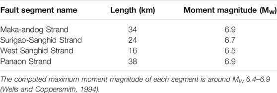
TABLE 1. Computed maximum moment magnitude for each segment of the Philippine Fault in Surigao Strait using the mapped fault segment length.
Seismicity data from the PHIVOLCS earthquake catalog (1901–2019) show shallow (0–30 km) to intermediate deep earthquakes (151–200 km) occurring along Surigao Strait (Figure 9A). These shallow earthquakes could be attributed to shallow crustal faults such as the Philippine Fault in Surigao Strait. Shallow earthquakes dominate the area, with clusters surrounding the trace of the Philippine Fault in Surigao Strait (Figure 9B). PHIVOLCS, USGS, and GCMT catalogs indicate that the epicenter of the 2017 MS 6.7 Surigao del Norte earthquake is 880 m west, 6.7 km, and 8.6 km east of the Surigao-Sanghid Strand, respectively (GCMT, 2017; USGS, 2017; DOST-PHIVOLCS, 2018). The derived earthquake plots are too distant relative to the trace of the Philippine Fault in Surigao Strait even though the computed dip of the earthquake from the focal mechanism is almost vertical. This suggests that the earthquake location plotting contains uncertainties, possibly due to the low quality of automated picking of P- and S-waves in the seismogram, inaccuracy/inappropriateness of the velocity models used, the sparse seismic network, and bias on the location of earthquake due to the position of the seismic stations relative to the fault. Hence, interpretation of the seismogenic fault from the earthquake locations should be treated with caution, especially in the absence of other datasets on the location of the earthquake’s surface rupture derived from the field and/or remote sensing observations. Despite earthquake location uncertainties, they give us an idea of the general strike of the fault.
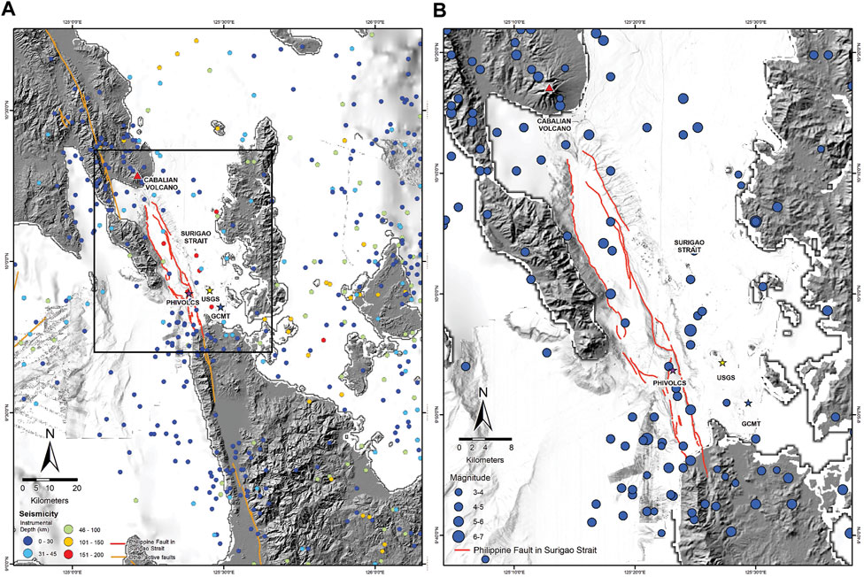
FIGURE 9. (A) Instrumental data (1901–2019) from DOST-PHIVOLCS (2019c) and historical seismicity data from and Bautista and Oike (2000) in Surigao Strait and the surrounding area. Also, shown are the plots of the 2017 MS 6.7 Surigao del Norte earthquake from DOST-PHIVOLCS (2019c), USGS (2017), and GCMT (2017). (B) Zoomed-in version of Figure 9A showing that the 0–30 km depth earthquakes, some of which could be attributed to the movement along the Philippine Fault in Surigao Strait.
The 2017 earthquake is generated by a strike-slip fault with a dip-slip component (predominantly normal slip), which is consistent with other focal mechanisms of the earthquakes within its vicinity (Figures 10, 11). These earthquakes could then be attributed to the Philippine Fault in Surigao Strait since it is the only mapped active fault in the area having a left-lateral motion. Intermediate-depth earthquakes, which define a 200-km-deep Wadati–Benioff zone, could be attributed to the subducting slab of the Philippine Sea Plate (Lallemand et al., 1998). The focal mechanism of these deep earthquakes was not included in the GCMT catalog probably due to the relatively low magnitude of these earthquakes. Additionally, the limited number of seismic stations capturing the seismic waveforms also prevented the generation of their focal mechanisms.
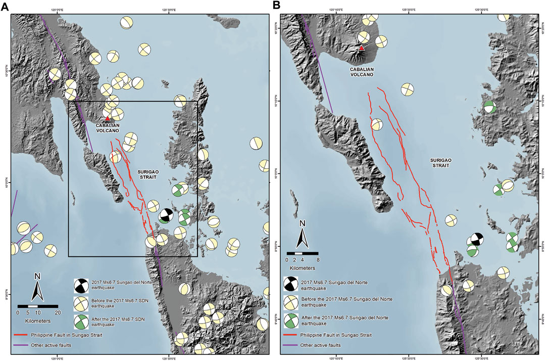
FIGURE 10. (A) Focal mechanism of earthquakes in Surigao Strait from the GCMT catalog (Ekström et al., 2012; GCMT, 2017). The focal mechanism of the 2017 MS 6.7 Surigao del Norte earthquake shows strike-slip faulting with minor normal motion. (B) Zoomed-in map [shown as a black box in (A)] showing the focal mechanism of earthquakes in Surigao Strait. Some of the strike-slip focal mechanisms could be attributed to the Philippine Fault in Surigao Strait.
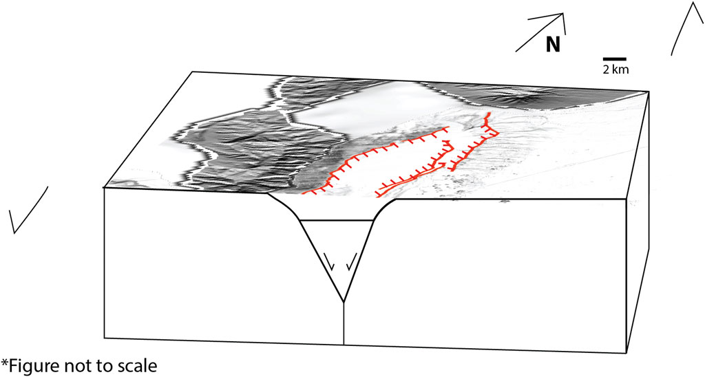
FIGURE 11. Block diagram showing the relationship of the mapped traces of the Philippine Fault in Surigao Strait in Maka-andog Deep. The opposite-dipping strike-slip fault traces with normal displacement are possibly connected to a master fault at depth. This is an expression of a negative flower structure. The other fault traces located in pull-apart basins within Surigao Strait could also have this kind of relationship.
Further to the NNW in the vicinity of the Cabalian volcano, numerous focal mechanisms suggest strike-slip faulting. As previously discussed, these earthquakes within the Cabalian volcano could correspond to an NW-SE-trending left-lateral fault that connects with the northwest edge of the Maka-andog Strand.
This study determined the location, geometry, segments, and extent of the Philippine Fault in Surigao Strait and its relationship to the recent 2017 MS 6.7 Surigao del Norte earthquake. The results indicate that the Philippine Fault in Surigao Strait starts from the southern coast of Leyte, which is located south of the Cabalian volcano, up until the coast of Surigao del Norte. The segment was identified through the presence of linear ridges, linear valleys, offset streams, fault scarps, and pull-apart basins. Four segments of the Philippine Fault in Surigao Strait were mapped based on their geometrical characteristics such as the presence of fault steps forming pull-apart basins and the formation of fault branches. The four segments are the Maka-andog Strand, Surigao-Sanghid Strand, Panaon Strand, and West Sanghid Strand. Based on the length of each segment, they could produce earthquakes with MW from 6.4 to 6.9. These segments showed both strike-slip and dip-slip (predominantly normal slip) faulting in bathymetry data. The traces of the Philippine Fault in Surigao Strait in sub-bottom profiles and seismic reflection profiles show normal displacement in basin-bounding faults. These traces coincide with the mapped traces of the Surigao-Sanghid Segment and West Sanghid Segment, which also have a normal slip. The presence of a significant amount of normal slip is due to transtensional deformation. The transtensional deformation is a product of left fault stepover which generated the pull-apart basins. Some of these pull-apart basins are bounded by opposite-dipping faults, which could be connected to a master fault at depth. The kinematics derived from the mapping of the fault is also consistent with the focal mechanism of earthquakes in the area, which shows predominantly strike-slip faulting with normal displacement. This corroborates the previous study by Aurelio et al. (1997a) that Surigao Strait is dominated by a transtensional tectonic regime.
The 2017 MS 6.7 Surigao del Norte earthquake was generated by the movement of the Surigao-Sanghid Segment based on the offshore fault mapping conducted in this study and mapping of the earthquake surface rupture onshore. The computed total length of the Surigao-Sanghid Segment is 24–25 km, which could produce a MW 6.7 based on the empirical equation of Wells and Coppersmith (1994). The MW 6.7 is consistent with the seismically derived magnitude of MS 6.7.
The original contributions presented in the study are included in the article/Supplementary Material, further inquiries can be directed to the corresponding author.
BM performed the conceptualization, data analysis, writing most of the manuscript draft, review and editing and field investigation. DL also performed conceptualization, interpretation, review and editing, and field investigation. MA reviewed the manuscript and supervised the research.
The funding for this research is provided by the Department of Science and Technology-Philippine Institute of Volcanology and Seismology (DOST-PHIVOLCS) of the Philippine government under the project titled “Offshore Active Faults Mapping in the Philippines”.
The authors declare that the research was conducted in the absence of any commercial or financial relationships that could be construed as a potential conflict of interest.
All claims expressed in this article are solely those of the authors and do not necessarily represent those of their affiliated organizations, or those of the publisher, the editors and the reviewers. Any product that may be evaluated in this article, or claim that may be made by its manufacturer, is not guaranteed or endorsed by the publisher.
The authors would like to acknowledge Emmanuelle D. Mitiam for providing field assistance and logistical support. They also would like to thank the members of the DOST-PHIVOLCS Quick Response Team (QRT) for sharing their data on the geologic impacts generated by the 2017 Surigao del Norte earthquake. They would also like to thank NAMRIA for providing the bathymetry data and DOE for providing the seismic reflection profiles in Surigao Strait. They would also like to thank Surigao City Mayor Ernesto Matugas and his office for assisting with our fieldwork back in 2018. They would also like to thank Prof. Shu-Kun Hsu for providing the Chesapeake Technology SonarWiz 7 processing software under the Republic of the Philippines-Taiwan MOVE project. They would also like to thank Jeffrey S. Perez, Dr. Jeremy M. Rimando, Kathleen L. Papiona, and Valerie Shayne V. Olfindo for their comments and suggestions which greatly improved this manuscript. They would also like to thank MQ, J-CL, and SÖ for their valuable reviews and suggestions. Lastly, the authors thank ZC for the editorial handling of this manuscript.
Allen, C. R. (1962). Circum-Pacific Faulting in the Philippines-Taiwan Region. J. Geophys. Res. 67, 4795–4812. doi:10.1029/JZ067i012p04795
Armada, L., Hsu, S.-K., Ku, C.-Y., Doo, W.-B., Wu, W.-N., Dimalanta, C., et al. (2012). Possible Northward Extension of the Philippine Fault Zone Offshore Luzon Island (Philippines). Mar. Geophys. Res. 33, 369–377. doi:10.1007/s11001-013-9169-5
Aurelio, M. A., Barrier, E., Rangin, C., and Müller, C. (1991). The Philippine Fault in the Late Cenozoic Tectonic Evolution of the Bondoc-Masbate-N. Leyte Area, Central Philippines. J. Southeast Asian Earth Sci. 6, 221–238. doi:10.1016/0743-9547(91)90069-A
Aurelio, M. A., Peña, R. E., and Taguibao, K. J. L. (2013). Sculpting the Philippine Archipelago since the Cretaceous through Rifting, Oceanic Spreading, Subduction, Obduction, Collision and Strike-Slip Faulting: Contribution to IGMA5000. J. Asian Earth Sci. 72, 102–107. doi:10.1016/j.jseaes.2012.10.007
Aurelio, M. A. (2000). Shear Partitioning in the Philippines: Constraints from Philippine Fault and Global Positioning System Data. Isl. Arc 9, 584–597. doi:10.1111/j.1440-1738.2000.00304.x10.1046/j.1440-1738.2000.00304.x
Aurelio, M. A., Valencia, T., and Quebral, R. (1997a). “Transtensional Deformation Linking Leyte and Mindanao,” in Contrib. To GEOCON 97 Trail Blaz. Into Next Era, 1–8.
Aurelio, M., Barrier, E., Gaulon, R., and Rangin, C. (1997b). Deformation and Stress States along the central Segmentof the Philippine Fault: Implications to Wrench Fault Tectonics. J. Asian Earth Sci. 15, 107–119. doi:10.1016/S0743-9547(97)00001-9
Bacolcol, T., Agnes, A., Luis, A., Jorgio, R., Pelicano, A., Solidum, R. U., et al. (2012). Current Motions of the Philippine Mobile Belt Derived from Global Positioning System Data. Quezon City.
Bautista, M. L. P., and Oike, K. (2000). Estimation of the Magnitudes and Epicenters of Philippine Historical Earthquakes. Tectonophysics 317, 137–169. doi:10.1016/S0040-1951(99)00272-3
Bischke, R. E., Suppe, J., and del Pilar, R. (1990). A New branch of the Philippine Fault System as Observed from Aeromagnetic and Seismic Data. Tectonophysics 183, 243–264. doi:10.1016/0040-1951(90)90419-9
Bonita, J. D., Kumagai, H., Kumagai, H., and Nakano, M. (2015). Regional Moment Tensor Analysis in the Philippines: CMT Solutions in 2012-2013. J. Disaster Res. 10, 18–24. doi:10.20965/jdr.2015.p0018
Borcherdt, R. D., Helley, E. J., Lajoie, K. R., and Wentworth, C. M. (1975). “Faults and Future Earthquakes,” in ” in Studies For Seismic Zonation Of the San Francisco Bay Region. Editor R. D. Borcherdt (Reston: USGS), 15–30. doi:10.3133/pp941A
Cunningham, W. D., and Mann, P. (2007). Tectonics of Strike-Slip Restraining and Releasing Bends. Geol. Soc. Lond. Spec. Publications 290, 1–12. LP – 12. doi:10.1144/SP290.1
Delos Reyes, P. J., Bornas, M. A. V., Dominey-Howes, D., Pidlaoan, A. C., Magill, C. R., and Solidum, Jr., R. U. (2018). A Synthesis and Review of Historical Eruptions at Taal Volcano, Southern Luzon, Philippines. Earth-Science Rev. 177, 565–588. doi:10.1016/j.earscirev.2017.11.014
DePolo, C. M., Clark, D. G., Slemmons, D. B., and Ramelli, A. R. (1991). Historical Surface Faulting in the Basin and Range Province, Western North America: Implications for Fault Segmentation. J. Struct. Geology. 13, 123–136. doi:10.1016/0191-8141(91)90061-M
DOST-PHIVOLCS (2019a). “Active Volcano Lists,” in PHIVOLCS-LAVA, 2. Available at: https://vmepd.phivolcs.dost.gov.ph/volcan/active?page=2&per-page=10 (Accessed August 15, 2019).
Ekström, G., Nettles, M., and Dziewoński, A. M. (2012). The Global CMT Project 2004-2010: Centroid-Moment Tensors for 13,017 Earthquakes. Phys. Earth Planet. Interiors 200-201, 1–9. doi:10.1016/j.pepi.2012.04.002
Fitch, T. J. (1972). Plate Convergence, Transcurrent Faults, and Internal Deformation Adjacent to Southeast Asia and the Western Pacific. J. Geophys. Res. 77, 4432–4460. doi:10.1029/JB077i023p04432
GCMT (2017). Global CMT Catalog. Available at: https://www.globalcmt.org/cgi-bin/globalcmt-cgi-bin/CMT5/form?itype=ymd&yr=2017&mo=2&day=9&otype=ymd&oyr=2017&omo=2&oday=10&jyr=1976&jday=1&ojyr=1976&ojday=1&nday=1&lmw=0&umw=10&lms=0&ums=10&lmb=0&umb=10&llat=9&ulat=10&llon=125&ulon=126&lhd=0&uhd=1000<s (Accessed February 10, 2017).
Hamilton, W. B. (1979). Tectonics of the Indonesian Region. Denver: U.S. Govt. Print. Off., doi:10.3133/pp1078
Hamling, I. J., Hreinsdóttir, S., Clark, K., Elliott, J., Liang, C., Fielding, E., et al. (2017). Complex Multifault Rupture during the 2016 M W 7.8 Kaikōura Earthquake, New Zealand. Science 356, eaam7194. doi:10.1126/science.aam7194
Hayes, D. E., and Lewis, S. D. (1984). A Geophysical Study of the Manila Trench, Luzon, Philippines: 1. Crustal Structure, Gravity, and Regional Tectonic Evolution. J. Geophys. Res. 89, 9171–9195. doi:10.1029/JB089iB11p09171
Hayes, D. E., and Lewis, S. D. (1985). Structure and Tectonics of the Manila Trench System, Western Luzon, Philippines. Energy 10, 263–279. doi:10.1016/0360-5442(85)90046-5
Hirano, S.-i., Nakata, T., and Sangawa, A. (1986). Fault Topography and Quaternary Faulting along the Philippine Fault Zone, Central Luzon, the Philippines. J. Geogr. (Chigaku Zasshi) 95, 71–93. doi:10.5026/jgeography.95.2_71
Ikeda, M., Toda, S., Kobayashi, S., Ohno, Y., Nishizaka, N., and Ohno, I. (2009). Tectonic Model and Fault Segmentation of the Median Tectonic Line Active Fault System on Shikoku, Japan. Tectonics 28, a–n. doi:10.1029/2008TC002349
Katayanagi, Y. (2021). SimpleDEMViewer. Available at: http://www.jizoh.jp/english.html#doc3.
Lagmay, A. M., Tejada, M. L., Pena, R., Aurelio, M., Davy, B., David, S., et al. (2009). New Definition of Philippine Plate Boundaries and Implications to the Philippine Mobile Belt. J. Geol. Soc. Philipp. 64, 17–30.
Lallemand, S. E., Popoff, M., Cadet, J.-P., Bader, A.-G., Pubellier, M., Rangin, C., et al. (1998). Genetic Relations between the central and Southern Philippine Trench and the Sangihe Trench. J. Geophys. Res. 103, 933–950. doi:10.1029/97JB02620
Lewis, S. D., and Hayes, D. E. (1983). The Tectonics of Northward Propagating Subduction along Eastern Luzon, Philippine Islands. Tecton. Geol. Evol. Southeast. Asian Seas Islands Part. 2, 57, 78. doi:10.1029/GM027p0057
Lewis, S. D., and Hayes, D. E. (1984). A Geophysical Study of the Manila Trench, Luzon, Philippines: 2. Fore Arc basin Structural and Stratigraphic Evolution. J. Geophys. Res. 89, 9196–9214. doi:10.1029/JB089iB11p09196
Mangahas, R., Marfito, B., Llamas, D. C., Sevilla, W. I., Bacolcol, T., Perez, J. S., et al. (2018). “Coulomb Stress Transfer and Tectonic Loading in Central Philippines: Relationship of the Recent Earthquakes from 2012 to 2017,” in AOGS-EGU Joint Conference Natural Hazards 2018, February 2018.
Marfito, B., Llamas, D. C., Mangahas, R., Bonita, J., Perez, J. S., Bacolcol, T., et al. (2017). Coulomb Stress Transfer Associated with 10 February 2017 Magnitude 6.7 Surigao Earthquake in GEOCON 2017
Morante, E. M. (1974). The Ragay Gulf Earthquake of March 17, 1973, Southern Luzon, Philippines. J. Geol. Soc. Philipp. XXVIII, 1–31.
Nakano, M., Kumagai, H., and Inoue, H. (2008). Waveform Inversion in the Frequency Domain for the Simultaneous Determination of Earthquake Source Mechanism and Moment Function. Geophys. J. Int. 173, 1000–1011. doi:10.1111/j.1365-246X.2008.03783.x
Perez, J. S., and Tsutsumi, H. (2017). Tectonic Geomorphology and Paleoseismology of the Surigao Segment of the Philippine Fault in Northeastern Mindanao Island, Philippines. Tectonophysics 699, 244–257. doi:10.1016/j.tecto.2017.02.001
Perez, J. S., Tsutsumi, H., Tsutsumi, H., Cahulogan, M. T., Cabanlit, D. P., Abigania, M. I. T., et al. (2015). Fault Distribution, Segmentation and Earthquake Generation Potential of the Philippine Fault in Eastern Mindanao, philippines. J. Disaster Res. 10, 74–82. doi:10.20965/jdr.2015.p0074
Pinet, N., and Cobbold, P. R. (1992). Experimental Insights into the Partitioning of Motion within Zones of Oblique Subduction. Tectonophysics 206, 371–388. doi:10.1016/0040-1951(92)90388-M
Pubellier, M., Quebral, R., Rangin, C., Deffontaines, B., Muller, C., Butterlin, J., et al. (1991). The Mindanao Collision Zone: a Soft Collision Event within a Continuous Neogene Strike-Slip Setting. J. Southeast Asian Earth Sci. 6, 239–248. doi:10.1016/0743-9547(91)90070-E
Pubellier, M., Bader, A. G., Rangin, C., Deffontaines, B., and Quebral, R. (1999). Upper Plate Deformation Induced by Subduction of a Volcanic Arc: the Snellius Plateau (Molucca Sea, Indonesia and Mindanao, Philippines). Tectonophysics 304, 345–368. doi:10.1016/S0040-1951(98)00300-X
Punongbayan, B. J. T., Kumagai, H., Kumagai, H., Pulido, N., Bonita, J. D., Nakano, M., et al. (2015). Development and Operation of a Regional Moment Tensor Analysis System in the Philippines: Contributions to the Understanding of Recent Damaging Earthquakes. J. Disaster Res. 10, 25–34. doi:10.20965/jdr.2015.p0025
Quebral, R. D., Pubellier, M., and Rangin, C. (1996). The Onset of Movement on the Philippine Fault in Eastern Mindanao: A Transition from a Collision to a Strike-Slip Environment. Tectonics 15, 713–726. doi:10.1029/95TC00480
Rangin, C., Le Pichon, X., Mazzotti, S., Pubellier, M., Chamot-Rooke, N., Aurelio, M., et al. (1999). Plate Convergence Measured by GPS across the Sundaland/Philippine Sea Plate Deformed Boundary: The Philippines and Eastern Indonesia. Geophys. J. Int. 139, 296–316. doi:10.1046/j.1365-246X.1999.00969.x
Research Group for Active Faults of Japan (1991). Active Faults in Japan - Sheet Maps and Inventories. Tokyo: Tokyo Univ. Press.
Rimando, R. E., and Knuepfer, P. L. K. (2006). Neotectonics of the Marikina Valley Fault System (MVFS) and Tectonic Framework of Structures in Northern and central Luzon, Philippines. Tectonophysics 415, 17–38. doi:10.1016/j.tecto.2005.11.009
Rimando, R. E., Rimando, J. M., and Lim, R. B. (2020). Complex Shear Partitioning Involving the 6 February 2012 MW 6.7 Negros Earthquake Ground Rupture in Central Philippines. Geosciences 10, 460. doi:10.3390/geosciences10110460
Rimando, R. E., and Rimando, J. M. (2020). Morphotectonic Kinematic Indicators along the Vigan-Aggao Fault: The Western Deformation Front of the Philippine Fault Zone in Northern Luzon, the Philippines. Geosciences 10, 83. doi:10.3390/geosciences10020083
Rimando, J. M., Aurelio, M. A., Dianala, J. D. B., Taguibao, K. J. L., Agustin, K. M. C., Berador, A. E. G., et al. (2019). Coseismic Ground Rupture of the 15 October 2013 Magnitude (MW) 7.2 Bohol Earthquake, Bohol Island, Central Philippines. Tectonics 38, 2558–2580. doi:10.1029/2019TC005503
Schwartz, D. P., and Sibson, R. H. (1989). Proceedings of Conference XLV; a Workshop on Fault Segmentation and Controls of Rupture Initiation and Termination. Palm Springs: U.S. Geological Survey. doi:10.3133/ofr89315
Sylvester, A. G. (1988). Strike-slip Faults. GSA Bull. 100, 1666–1703. doi:10.1130/0016-7606(1988)100<1666:ssf>2.3.co;2
Tiesheng, W. (2020). Draw Focal Mechanism beach Balls as Arcgis Shapefile. ArcGIS Hub. Available at: https://hub.arcgis.com/content/380b8f93cd684dbea56083218a3b2f43/about (Accessed March 19, 2021).
Tsutsumi, H., and Perez, J. S. (2013). Large-scale Active Fault Map of the Philippine Fault Based on Aerial Photograph Interpretation. Act. Fault Res. 2013, 29–37. doi:10.11462/afr.2013.39_29
Tsutsumi, H., Perez, J. S., Perez, J. S., Marjes, J. U., Papiona, K. L., and Ramos, N. T. (2015). Coseismic Displacement and Recurrence Interval of the 1973 Ragay Gulf Earthquake, Southern Luzon, Philippines. J. Disaster Res. 10, 83–90. doi:10.20965/jdr.2015.p0083
USGS (2017). M 6.5 - 11 Km N of Mabua, Philippines. Available at: https://earthquake.usgs.gov/earthquakes/eventpage/us20008ixa/executive (Accessed February 10, 2017).
Vedder, J. G., and Wallace, R. E. (1970). Map Showing Recently Active Breaks along the San Andreas and Related Faults between Cholame Valley and Tejon Pass. California. doi:10.3133/i574
Wells, D. L., and Coppersmith, K. J. (1994). New Empirical Relationships Among Magnitude, Rupture Length, Rupture Width, Rupture Area, and Surface Displacement. Bull. Seismol. Soc. Am. 84, 974–1002. doi:10.1785/BSSA0840040974
Wesnousky, S. G. (2006). Predicting the Endpoints of Earthquake Ruptures. Nature 444, 358–360. doi:10.1038/nature05275
Wesnousky, S. G. (2008). Displacement and Geometrical Characteristics of Earthquake Surface Ruptures: Issues and Implications for Seismic-Hazard Analysis and the Process of Earthquake Rupture. Bull. Seismological Soc. America 98, 1609–1632. doi:10.1785/0120070111
World Bank (2005). Natural Disaster Risk Management in the Philippines Reducing Vulnerability. Available at: https://openknowledge.worldbank.org/handle/10986/8754%0A.https://openknowledge.worldbank.org/handle/10986/8754.License: CC BY 3.0 IGO.
Keywords: offshore faults, submarine faults, Philippine Fault, Surigao Strait, active tectonics
Citation: Marfito BJ, Llamas DCE and Aurelio MA (2022) Geometry and Segmentation of the Philippine Fault in Surigao Strait. Front. Earth Sci. 10:799803. doi: 10.3389/feart.2022.799803
Received: 22 October 2021; Accepted: 13 January 2022;
Published: 03 March 2022.
Edited by:
Ziyadin Cakir, Istanbul Technical University, TurkeyReviewed by:
Mark Quigley, The University of Melbourne, AustraliaCopyright © 2022 Marfito, Llamas, and Aurelio. This is an open-access article distributed under the terms of the Creative Commons Attribution License (CC BY). The use, distribution or reproduction in other forums is permitted, provided the original author(s) and the copyright owner(s) are credited and that the original publication in this journal is cited, in accordance with accepted academic practice. No use, distribution or reproduction is permitted which does not comply with these terms.
*Correspondence: Bryan J. Marfito, YnJ5YW4ubWFyZml0b0BwaGl2b2xjcy5kb3N0Lmdvdi5waA==
Disclaimer: All claims expressed in this article are solely those of the authors and do not necessarily represent those of their affiliated organizations, or those of the publisher, the editors and the reviewers. Any product that may be evaluated in this article or claim that may be made by its manufacturer is not guaranteed or endorsed by the publisher.
Research integrity at Frontiers
Learn more about the work of our research integrity team to safeguard the quality of each article we publish.