 Juan Zou
 Guoyong Liu2
95% of researchers rate our articles as excellent or good
Learn more about the work of our research integrity team to safeguard the quality of each article we publish.
Find out more
ORIGINAL RESEARCH article
Front. Earth Sci. , 06 January 2023
Sec. Structural Geology and Tectonics
Volume 10 - 2022 | https://doi.org/10.3389/feart.2022.1057660
This article is part of the Research Topic Unconventional Reservoir Geomechanics View all 16 articles
There are great differences in oil and gas enrichment at different locations in petroliferous basins, and faults are an important factor affecting the differential enrichment of oil and gas. In this paper, taking the No. 2 structure in the Nanpu Sag, Bohai Bay Basin, East China, as an example, based on the analysis of fault geometry and kinematics characteristics, the determination of oil source faults, the analysis of fault trap origin and effectiveness, and the analysis of fault caprock combinations are carried out to study the differences and mechanisms of oil and gas enrichment east and west of the Nanpu No. 2 structure. The results show that the fault-source contact relationship affects the direction of oil and gas migration. The No. 2 structure in the Nanpu Sag has a dual-source hydrocarbon supply. The western structure supplies hydrocarbons from the north and east, with oil and gas migrating along the direction parallel and perpendicular to the fault strike. The east structure supplies hydrocarbons from the south and north, with oil and gas migrating along the direction perpendicular to the fault strike. The effectiveness of fault traps affects the scale of oil and gas accumulation. Most of the traps of the Nanpu No. 2 structure formed before hydrocarbon expulsion, which are all effective traps and are conducive to oil and gas accumulation. The relationship between fault and caprock determines the vertical accumulation layers of oil and gas: The faulted thickness of the east structure is large, the fault is vertically closed, and oil and gas are enriched mainly in the deep layer. The faulted thickness of the west structure is small, and oil and gas are enriched in both deep and shallow layers.
Oil and gas accumulation conditions in petroliferous basins are complex, and the enrichment differences are large. Different sags, different structural belts in the same sag, and different structural positions in the same structural belt have different oil and gas reservoir types, different key control elements, and different accumulation characteristics. As one of the most important structures in petroliferous basins, the fault is the main factor controlling oil and gas migration, accumulation and dispersion. They are not only oil and gas migration channels but also oil and gas sealing surfaces (Wan et al., 2010, 2012), controlling oil and gas sources, traps, oil and gas migration and accumulation, and adjustment and destruction of oil and gas reservoirs. Oil and gas reservoirs have been found in many structural belts in the Nanpu Sag, Bohai Bay Basin, with great exploration potential. However, due to the superposition of three tectonic activities in Es, Ed, and the late Nm, the fault characteristics are complex, especially various fault combination styles, and multiphase and multisegment fault activities control oil and gas enrichment with great differences. In this paper, taking the No. 2 structure in the Nanpu Sag as an example, the characteristics and mechanism of hydrocarbon enrichment differences are analyzed from the study of fault activity.
The Nanpu Sag is located in the northeastern Huanghua Depression, the northern Chengning Uplift and the southwestern Liaodong Bay Depression in the Bohai Bay Basin. It is adjacent to the Yanshan fold belt in the north and the Bohai Sea in the south. It is further divided into seven secondary positive structural belts and four negative subsags according to structural differences.
The No. 2 structure is located in the middle south of the Nanpu Sag, adjacent to the Linque subsag in the north, the Caofeidian subsag in the southeast, the No. 1 structure in the west, and the No. 4 structure in the east, controlled by a series of NE-striking and nearly E‒W-striking faults (Figure 1).
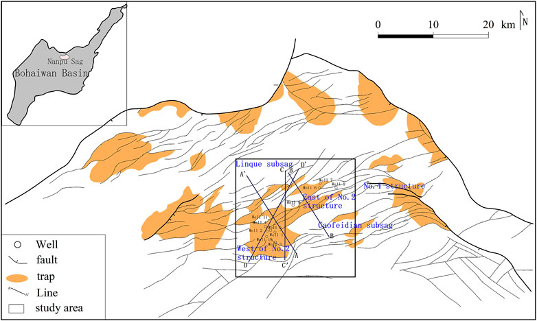
FIGURE 1. Regional structure location of the Nanpu No. 2 structure.
The Nanpu Sag is a multicycle Mesozoic and Cenozoic fault basin formed on the basis of the North China platform under the background of multiple tectonic movements: the stable development period of the Paleozoic platform, the disintegration period of the Mesozoic platform, and the formation and development period of the Cenozoic basin. Its geological conditions are complex, and its oil and gas resources are rich (Cui et al., 2018). Five sets of strata, including Archean, Proterozoic, Paleozoic, Mesozoic and Cenozoic strata, are developed from bottom to top in the Nanpu No. 2 structure (Figure 2). Hydrocarbon source rocks are developed in the Cenozoic Paleogene, including the Es3, Es1, and Ed3 Formations (Wang et al., 2020). The reservoirs include clastic rock (sandstone) reservoirs (Kashif et al., 2019), carbonate rock reservoirs and volcanic rock reservoirs, among which sandstone reservoirs are the main reservoirs.
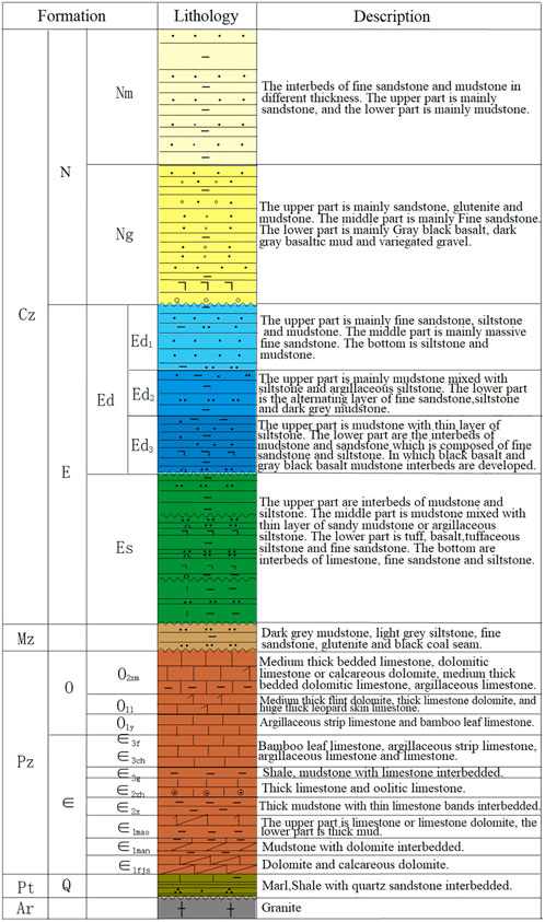
FIGURE 2. Stratigraphic column of the Nanpu No. 2 structure.
The Nanpu Sag has long oil-bearing intervals, multiple exploration strata, rich reservoir types and multiple oil and gas accumulations (Jiang et al., 2018; Wang et al., 2019). Oil and gas have been found in the Neogene Nm and Ng Formations, the Paleogene Ed and Es Formations, the Mesozoic Jurassic, and the Paleozoic Cambrian and Ordovician strata, concluding above-source, intrasource and below-source accumulation models.
The faults in the Nanpu No. 2 structure are complex, and fault identification has multiple solutions. Based on the latest seismic processing data, combined with the fault development model and the prediction of low-order faults by stress field simulation, the faults are identified in detail (Liu et al., 2018). The faults in the Nanpu No. 2 structure are characterized by mixed scales, different fault distances, different extension lengths, and obvious hierarchical sequences. The fault grade is divided according to the fault extension length and cutting depth. In combination with the fault occurrence of different levels and the contact relationship of the fault plane and profile, the structure style is recognized. On this basis, the fault displacement–distance curve and section buried depth contour are used to quantitatively characterize and analyze the segmented growth process of the main faults in the Nanpu No. 2 structure, to identify the distribution and evolution of segmented points and complete segments and to determine the plane and vertical segmentation of the main fault (Wang et al., 2014; Liu J et al., 2022).
On the basis of fault analysis, the relationship between faults and reservoirs is studied. First combined with the seismic data interpretation scheme of multiple rounds of processing, the oil source fault is determined by analyzing the cutting relationship and contact area between the fault and the source rock. Then, the fault displacement–distance curve is used based on the analysis of fault kinematics characteristics to restore fault activity during the hydrocarbon expulsion period to determine the effectiveness of traps. Finally, for more than 50 drilled wells in the Nanpu No. 2 structure, stratigraphic correlation is conducted according to lithological combinations and logging curves, a thick mudstone section at the top of Ed2 is identified, and the mudstone thickness at the top of Ed2 of each well drilled into Ed2 is counted. The fault distance of each fault at the top of Ed2 is calculated by using the fault drop method, and then the faulted thickness is obtained by calculating the difference in fault distance and mudstone thickness to analyze the vertical sealing property of the fault. To further clarify the differences in oil and gas accumulation.
The Nanpu No. 2 structure has experienced three periods of intense activity since the Paleogene (Liu and Zhang, 2011; Zhao et al., 2019): Es3, the end of Ed and the end of Nm. During the Es periods, it was subjected to NW-SE extension and developed NE-striking large faults. During the Ed periods, it was subjected to NNW-SSE extension, and NE-striking faults continued to grow. At the same time, NEE-SWW strike faults were developed. In the Neogene periods, it became nearly NS extension. Some old faults inherited, and some near-EW strike small faults newly developed with parallel or oblique combination in the plane. The large fault is characterized by multiple episodes in the vertical direction and multiple sections in the plane (Peacock and Sanderson, 1991; Trudgill and Cartwright, 1994; Cartwright et al., 1995; Kim and Sanderson, 2005). There are NE-striking and nearly E-W-striking faults in the west structure, which are in fault terrace style (Figure 3A) controlled by the development of a series of north-dipping faults cutting the basement on the buried hill background. The faults in the east structure have a basically NE strike. The Mesozoic sedimentary rocks represent a buried hill background. It developed a wide and gentle anticline structure in the Es3 period. During the Ed period, the activities of the reverse faults, which are deep basement, controlled the development of one horst structure and two compound “Y” styles (Figure 3B) in the north and south (Figure 4).
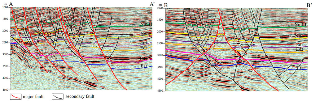
FIGURE 3. Structural Style Profile of the Nanpu No. 2 structure. (A) Fault terrace style formed by a series of north-dipping faults cutting the basement in the west of the Nanpu No. 2 structure. (B) Two compound “Y” styles formed by two major faults with opposite dips and several secondary faults in the east of the Nanpu No. 2 structure.
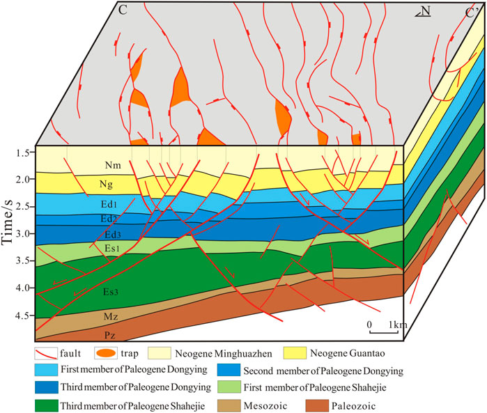
FIGURE 4. Structural distribution in the east of the Nanpu No. 2 structure. The faults have a basically NE strike, which controls the crosscut fault block trap and fault nose trap. It developed a wide and gentle anticline structure in Es3 and compound “Y” styles in Ed.
The Nanpu No. 2 structure is adjacent to the Linque subsag and Caofeidian subsag in the north and south, which have a two-way oil source. Three sets of hydrocarbon source rocks are developed in Es3, Es1 and Ed3. The oil source is sufficient. Whether the fault can connect the hydrocarbon source rocks is the key to determining the oil source fault. Based on the analysis of the vertical episodic nature of the fault activity, the oil source faults are determined by combining the cutting relationship and contact area between the faults and the source rock. The faults cut into one or more sets of hydrocarbon source rocks and developed during the hydrocarbon expulsion period can be regarded as the main oil source faults.
At the end of the Ed, there was a large amount of oil generation for the bottom hydrocarbon source rocks in Es3. At the end of Nm, the hydrocarbon source rocks at the bottom of Es1 and Ed3 entered the peak of oil generation (Sun et al., 2015), and the period of fault activity matched the period of hydrocarbon expulsion, linking the oil source well. The main oil source faults in the west structure are NW-dipping and NE-striking faults, which developed from Es3 to the end of Nm. The main oil source faults in the east structure are NEE strikes, which developed from Ed to the end of Nm, and some cut into Es. The oil source faults cut into both the Caofeidian subsag and Linque subsag and developed at the end of Nm, in which hydrocarbons expulsed.
The influence of faults on traps is shown in many aspects: fault combination controls trap type, fault activity controls trap development time, and fault activity controls trap transformation form. The Nanpu No. 2 structure is controlled by fault activity and mainly develops fault block traps and fault nose traps, including reverse fault traps located at the fault rising side and syndromic fault traps located at the fault falling side. The fault activity causes the uplift plate strata to tilt in the opposite direction to form a reverse fault trap, which is developed at the beginning of the fault activity. The fault descending wall strata moves downward, and the displacement of the connection part is small, forming the syndromic fault trap, so the syndromic fault trap is developed in the period of hard connection of segmented faults. The fault displacement-distance curve is used to carry out back stripping of fault activity, restore the fault activity intensity and extension length in the reservoir forming period, determine the formation time and scale of fault traps, and then determine the effectiveness of traps (Figure 5) (Liu L et al., 2022).
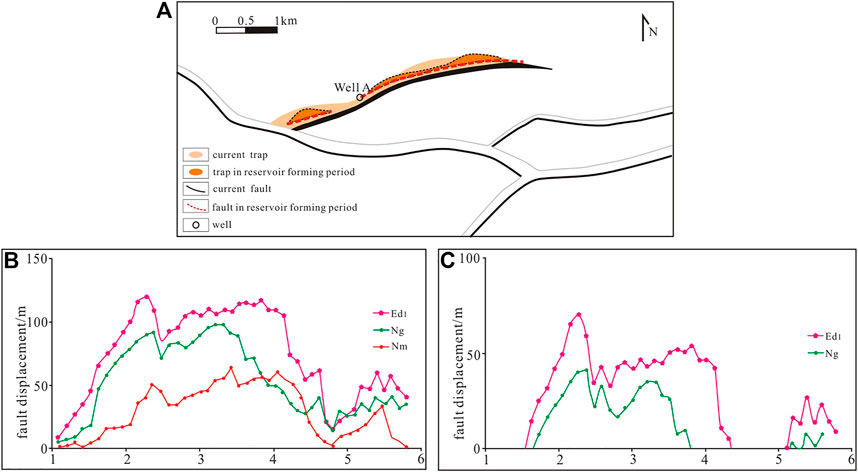
FIGURE 5. Control of fault segmentation activities on trap development. (A) Fault and trap distribution: The current fault is continuous, and Well A is in the current trap; The fault in the reservoir forming period is discontinuous, and Well A is not in the effective trap. (B) Current fault displacement-distance curve shows the fault segmentation. (C) Stripping the fault displacement-distance in the reservoir forming period in order to restore the trap in the reservoir forming period which is effective trap.
Faults play a dual role in the process of oil and gas migration and accumulation, which can not only become a channel for oil and gas migration from deep to shallow but also provide sealing conditions for oil and gas accumulation. Caprock plays an important role in hindering the vertical transmission of oil and gas. When the thickness of the caprock is large and the scale of the fault that breaks through the caprock is small, the caprock is not pulled off, the shear mudstone coating layer is thick, and the oil and gas are completely blocked in the vertical direction. In contrast, when the thickness of the caprock is small and the fault scale is large, the caprock is completely pulled off, with the fault opening vertically, and oil and gas continue to migrate upward. The Nanpu No. 2 structure develops three sets of stable caprocks, namely, the mudstone at the bottom of the Nm Formation, the volcanic rock in the middle of the Ng Formation, and the mudstone at the top of the Ed2 Formation. The mudstone at the top of Ed2 is thick, with differences from east to west. It is thicker in the east, with a maximum thickness of 310 m, and thinner in the west (Figure 6). Both the thickness of the mudstone caprock and the fault distance of Ed2 determine the difference in the faulted thickness of Ed2 in the Nanpu No. 2 structure. The greater the faulted thickness is, the more difficult it is for oil and gas to continue to migrate upward.
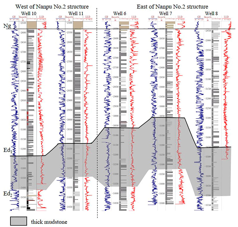
FIGURE 6. Stratigraphic correlation profile of the Nanpu No. 2 structure. Well 10 and well 11 are west of the Nanpu No. 2 structure (located in Figure 1), whose mudstone thickness at the top of Ed2 is 160 m. Well 6, well 7 and well 8 are east of the Nanpu No. 2 structure, whose mudstone thickness at the top of Ed2 is 250–300 m.
The Nanpu No. 2 structure is adjacent to the Caofeidian subsag in the southeast and the Linque subsag in the north. The main oil source faults in the west structure are NW dipping and NE strike, connecting the oil source of the Linque subsag in the north to migrate along the direction perpendicular to the fault strike and connecting the oil source of the Caofeidian subsag in the east to migrate along the direction parallel to the fault strike to the west. The main oil source faults in the east structure have an NEE strike. The NW-dipping oil source fault in the north connects the oil source of the Linque subsag, and the SE-dipping oil source fault in the south connects the oil source of the Caofeidian subsag, both of which migrate oil and gas to the tectonic horst along the direction perpendicular to the fault strike (Figure 7). Influenced by the relationship between the oil source fault strike and the middle shallow ancient landform in which the Nanpu No. 2 east structure is located in the low-lying area between the Nanpu No. 2 west structure and the Nanpu No. 4 structure (Figure 8), the oil and gas may continue to migrate to the higher part of the Nanpu No. 2 west structure and the Nanpu No. 4 structure on both sides along the direction of the NE fault strike after migrating to the middle shallow layer of the Nanpu No. 2 east structure. In addition, a few deep faults in the east structure are “conjugate”, with relatively poor longitudinal connectivity, resulting in relatively poor vertical oil and gas transmission capacity.
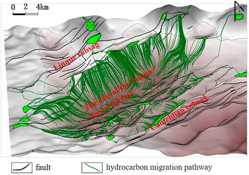
FIGURE 7. Oil and gas migration direction in the east of the Nanpu No.2 structure.
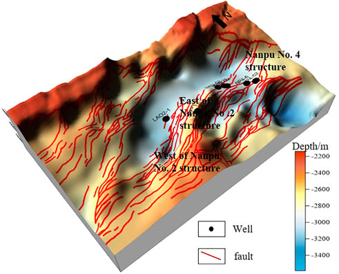
FIGURE 8. Ancient landform map of the Nanpu No.2 structure of Ed1.
Multiple fault combination styles of the Nanpu No. 2 structure control the development of multiple types of fault-related structural traps, which are mainly reverse fault block traps, and a small number of syndromic fault traps are also developed. Taking the trap in Ed1 as an example, the reverse fault trap on the upthrown block developing in the Es and Ed periods developed in Ed1, the same direction fault trap on the downthrown block developing in the Es and Ed periods developed at the fault hard connection period, and the reverse fault trap on the upthrown block developing in NmⅢ developed in NmⅢ. That is, most traps in Ed1 of the Nanpu No. 2 structure were formed in Ed1, and some were formed in NmⅢ. Moreover, particle fluorescence analysis also indicates that fault traps formed in the late Nm Formation sedimentation, and the QGF-E is generally greater than 40. The main filling period of the Ed1 traps of the Nanpu No. 2 structure is 2–3 Ma, which is the end of Nm. Therefore, the traps that formed in the Ed1 and NmⅢ stages are effective traps.
The mudstone caprock at the top of Ed2 of the Nanpu No. 2 structure affects the vertical transmission of oil and gas. The thickness of the mudstone caprock is 94–310 m, and it gradually increases from west to east. The fault displacement is 60–500 m. The faulted thickness of Ed2 in the east structure is more than 35 m, and the caprock is not damaged. The greater the faulted thickness of the caprock is, the greater the hindrance to oil and gas. In addition, the source rock has overpressure plugging, and the vertical sealing of the fault is good. Therefore, it is difficult for oil and gas to continue to migrate upward to the stratum above Ed2 in the east. The faulted thickness of Ed2 in the west structure is generally less than 35 m, which causes the vertical sealing property of the fault in the west structure to be poor, and the conductivity to be strong. Some oil and gas migrate upward to the Ed1, Ng and Nm reservoirs (Figure 9).
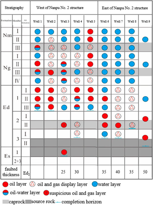
FIGURE 9. Faulted thickness and hydrocarbon distribution of the Nanpu No. 2 structure. The faulted thickness of Ed2 is generally less than 35 m, and the oil layer develops in the Es, Ed, Ng and Nm Formations in the west structure; the faulted thickness of Ed2 is generally more than 35 m, and the oil layer develops mainly below the Ed2 Formations in the east structure.
The Nanpu No. 2 structure has many oil layers and complicated oil-water relationships. Influenced by fault-source, fault-trap and fault-cap, the oil and gas enrichment are different between the west structure and the east structure. In the western structure, oil and gas are found in the Ordovician buried hill, Es, Ed, Ng, and Nm. The buried hill oil layer is developed in the Ordovician lower Majiagou Formation. The oil layer is enriched in the weathering crust at the high part of the buried hill, and the thickness of the oil and gas layer is 1.3–35.5 m. The Es Formation develops volcanic rock oil and gas reservoirs, and the Ed, Ng and Nm Formations are enriched in conventional sandstone oil and gas; that is, the oil and gas in the west structure are enriched in multiple layers from deep to shallow. The eastern structure mainly developed shale oil and gas reservoirs in the Es and Ed Formations and developed volcanic rock oil and gas reservoirs in the Ed Formation. The oil and gas are mainly enriched in the deep layer, and the oil- and gas-bearing properties are poor above the thick mudstone at the top of Ed2 (Figure 10).
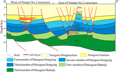
FIGURE 10. Oil reservoir profile of the Nanpu No. 2 structure. The oil and gas are enriched in multiple layers from deep to shallow in the west structure and only in the deep layers below Ed2 in the east structure.
1) The fault-source contact relationship affects the direction of oil and gas migration. The No. 2 structure in the Nanpu Sag has a dual-source hydrocarbon supply. The west structure supplies hydrocarbons from the north and east, with oil and gas migrating along the direction parallel and perpendicular to the fault strike. The east structure supplies hydrocarbons from the south and north, with oil and gas migrating along the direction perpendicular to the fault strike. The east and west structures of the No. 2 structure in the Nanpu Sag have favorable oil source conditions. Influenced by the relationship between the oil source fault strike and the middle shallow ancient landform and the fault longitudinal connectivity, the oil source condition of the middle shallow structure in the west is better than that in the east.
2) The effectiveness of fault traps affects the scale of oil and gas accumulation. The middle deep traps and shallow traps are both developed in the west and east structures of the Nanpu No. 2 structure. Most traps formed before hydrocarbon expulsion, which are all effective traps and are conducive to oil and gas accumulation.
3) The relationship between fault and caprock determines the vertical accumulation layers of oil and gas: A set of thick mudstone is developed at the top of Ed2 sedimentation, which controls the difference in oil- and gas-enriched strata. The faulted thickness of the east structure is large, the fault is vertically closed, and oil and gas are enriched mainly in the deep layer. The faulted thickness of the west structure is small, and oil and gas are enriched in both deep and shallow layers.
The original contributions presented in the study are included in the article/Supplementary Material, further inquiries can be directed to the corresponding author.
JZ, GL, and QM contributed to conception and design of the study. JZ and FY performed the statistical analysis. JZ, LM, and BT wrote and revised the manuscript. All authors approved the submitted version.
The authors JZ, QM, LM and BT were employed by the company PetroChina Jidong Oilfield. The author GL was employed by the company PetroChina Xinjiang Oilfield.
The remaining author declares that the research was conducted in the absence of any commercial or financial relationships that could be construed as a potential conflict of interest.
All claims expressed in this article are solely those of the authors and do not necessarily represent those of their affiliated organizations, or those of the publisher, the editors and the reviewers. Any product that may be evaluated in this article, or claim that may be made by its manufacturer, is not guaranteed or endorsed by the publisher.
Cartwright, J. A., Trudgill, B. D., and Mansfield, C. (1995). Fault growth by segment linkage: An explanation for scatter in maximum displacement and trace length data from the canyonlands grabens of SE Utah. J. Struct. Geol. 17 (9), 1319–1326. doi:10.1016/0191-8141(95)00033-a
Cui, L., Yang, L., and Wang, S. (2018). Tense-shearing characteristics and formation mechanism of basin edge—an example of in liuzan area in Nanpu sag[J]. Sci. Technol. Eng. 18 (22), 15–20. doi:10.3969/j.issn.1671-1815.2018.22.002
Jiang, F., Pang, X., Li, L., Wang, Q., Dong, Y., Hu, T., et al. (2018). Petroleum resources in the Nanpu sag, Bohai Bay Basin, eastern China. Am. Assoc. Pet. Geol. Bull. 102 (7), 1213–1237. doi:10.1306/0906171608017148
Kashif, M., Cao, Y. C., Yuan, G. H., Asif, M., Javed, K., Mendez, J. N., et al. (2019). Pore size distribution, their geometry and connectivity in deeply buried Paleogene Es1 sandstone reservoir, Nanpu Sag, East China. Pet. Sci. 16 (5), 981–1000. doi:10.1007/s12182-019-00375-3
Kim, Y. S., and Sanderson, D. J. (2005). The relationship between displacement and length of faults: A review. Earth. Sci. Rev. 68 (68), 317–334. doi:10.1016/j.earscirev.2004.06.003
Liu, J., Ding, W., Dai, J., Wu, Z., and Yang, H. (2018). Quantitative prediction of lower order faults based on the finite element method: A case study of the M35 fault block in the western hanliu fault zone in the gaoyou sag, east China. Tectonics 37 (10), 3479–3499. doi:10.1029/2017TC004767
Liu, X. F., and Zhang, C. M. (2011). Nanpu sag of the Bohai Bay Basin: A transtensional fault-termination basin. J. Earth Sci. 22 (06), 755–767. doi:10.1007/s12583-011-0225-2
Liu, J, J., Yang, H., Xu, K., Wang, Z., Liu, X., Cui, L., et al. (2022). Genetic mechanism of transfer zones in rift basins: Insights from geomechanical models. GSA Bull. 134 (9-10), 2436–2452. doi:10.1130/b36151.1
Liu, L, L., Sun, Y. H., Chen, C., Lou, R., and Wang, Q. (2022). Fault reactivation in No.4 structural zone and its control on oil and gas accumulation in Nanpu sag, Bohai Bay Basin, China. Petroleum Explor. Dev. 49 (04), 824–836. doi:10.1016/S1876-3804(22)60313-6
Peacock, D. C., and Sanderson, D. J. (1991). Displacements, segment linkage and relay ramps in normal fault zones. J. Struct. Geol. 13 (6), 721–733. doi:10.1016/0191-8141(91)90033-f
Sun, B., Tang, D., Li, X. M., et al. (2015). Hydrocarbon-generation Evolution of Source Rock and Oil-gas Source in Nanpu Depression, Bohai Bay Basin[J]. Sci. Technol. Eng. 15 (19), 67–73. doi:10.3969/j.issn.1671-1815.2015.19.013
Trudgill, B. D., and Cartwright, J. A. (1994). Relay-ramp forms and normal-fault linkages, Canyonlands National Park, Utah. Geol. Soc. Am. Bull. 106 (9), 1143–1157. doi:10.1130/0016-7606(1994)106<1143:rrfanf>2.3.co;2
Wan, T., Jiang, Y. L., Dong, Y. X., et al. (2012). Relationship between fault activity and hydrocarbon accumulation and enrichment in Nanpu depression[J]. J. China Univ. Petroleum 36 (2), 60–67. doi:10.3969/j.issn.1673-5005.2012.02.010
Wan, T., Jiang, Y. L., Lin, H. X., et al. (2010). Quantitative Evaluation of Fault Activity and Fault Sealing Property and Its Relationship with Hydrocar-bon Migration and Accumulation—By Taking Caojiazhuang Step-fault Zone in Chexi Sag for Example[J]. J. Oil Gas Technol. 32 (4), 18–24. doi:10.3969/j.issn.1000-9752.2010.04.004
Wang, E., Liu, G., Pang, X., Li, C., Zhao, Z., Feng, Y., et al. (2020). An improved hydrocarbon generation potential method for quantifying hydrocarbon generation and expulsion characteristics with application example of Paleogene Shahejie Formation, Nanpu Sag, Bohai Bay Basin. Mar. Petroleum Geol. 112, 104106–106. doi:10.1016/j.marpetgeo.2019.104106
Wang, E., Wang, Z., Pang, X., Zhang, Z., Wang, Z., Wu, Z, et al. (2019). Key factors controlling hydrocarbon enrichment in a deep petroleum system in a terrestrial rift basin—A case study of the uppermost member of the upper Paleogene Shahejie Formation, Nanpu Sag, Bohai Bay Basin, NE China. Mar. Petroleum Geol. 107, 572–590. doi:10.1016/j.marpetgeo.2019.05.027
Wang, H. X., Li, M. H., Shen, Z. S., Fu, X. F., Cheng, Z. Y., and Wang, B. (2014). The Establishment and Geological Significance of Quantitative Discrimination Criterion of Fault Segmentation Growth—An Example from Saertu Reservoir in Xingbei Development Area of Songliao Basin[J]. Geol. Rev. 60 (06), 1259–1264. doi:10.16509/j.georeview.2014.06.005
Keywords: fault source, fault trap, fault cap, difference in oil and gas enrichment, Nanpu No. 2 structure
Citation: Zou J, Liu G, Ma Q, Yu F, Meng L and Tian B (2023) Analysis of fault characteristics and oil and gas enrichment differences in the No. 2 structural belt, Nanpu Sag, Bohai Bay Basin, East China. Front. Earth Sci. 10:1057660. doi: 10.3389/feart.2022.1057660
Received: 29 September 2022; Accepted: 15 November 2022;
Published: 06 January 2023.
Edited by:
Jingshou Liu, China University of Geosciences Wuhan, ChinaReviewed by:
Kelai Xi, China Univeristy of Petroleum, ChinaCopyright © 2023 Zou, Liu, Ma, Yu, Meng and Tian. This is an open-access article distributed under the terms of the Creative Commons Attribution License (CC BY). The use, distribution or reproduction in other forums is permitted, provided the original author(s) and the copyright owner(s) are credited and that the original publication in this journal is cited, in accordance with accepted academic practice. No use, distribution or reproduction is permitted which does not comply with these terms.
*Correspondence: Juan Zou, em91anVhbjIwMTJAeWVhaC5uZXQ=
Disclaimer: All claims expressed in this article are solely those of the authors and do not necessarily represent those of their affiliated organizations, or those of the publisher, the editors and the reviewers. Any product that may be evaluated in this article or claim that may be made by its manufacturer is not guaranteed or endorsed by the publisher.
Research integrity at Frontiers
Learn more about the work of our research integrity team to safeguard the quality of each article we publish.