 Haixia Sui1
 Chang Liu
 Chengming Ye
 Tianbo Sui
94% of researchers rate our articles as excellent or good
Learn more about the work of our research integrity team to safeguard the quality of each article we publish.
Find out more
ORIGINAL RESEARCH article
Front. Earth Sci. , 18 January 2023
Sec. Geohazards and Georisks
Volume 10 - 2022 | https://doi.org/10.3389/feart.2022.1053327
This article is part of the Research Topic Monitoring, Early Warning and Mitigation of Natural and Engineered Slopes – Volume II View all 17 articles
The effects of geohazards on the ecological environment and ecological spatial pattern have received wide attention from scholars. However, the positive role played by ecological restoration projects on the environment and in the reduction of geohazards has usually been neglected. Jiuzhaigou Valley Scenic Area is a world natural heritage area, has a high incidence of geohazards, and is a demonstration area for ecological restoration projects. Based on remote sensing technology, this paper adopted an InVEST model (Integrated Valuation of Ecosystem Services and Tradeoffs) and ecological landscape index to extract information about spatio-temporal changes in Jiuzhaigou from 2013 to 2020. This study utilized a quantitative analysis of the ecological recoverability of Jiuzhaigou in cases of artificial restoration and spontaneous restoration under different types of geohazards. Results showed that forests play a vital role in maintaining and controlling habitat quality; artificial restoration can significantly ameliorate the impact of geohazards on the scenic area. As of 2020, the forested scenic area recovered 3.868
The evaluation of ecosystem services has guiding significance in promoting the coordinated development of regional construction and ecological environmental protection. Nature reserves are effective in maintaining biodiversity, improving the ecological environment and enhancing ecosystem service function (Maes et al., 2012; Van Vooren et al., 2018; Melzer and Bellingrath-Kimura, 2021). But natural reserves are vulnerable to human factors and geohazards. Among them, human impacts include the deterioration of the ecological environment caused by human disturbance; however, there is a benefit of human scientific management in ecological restoration. Therefore, analyzing the spatial and temporal evolution of regional ecosystem service functions not only helps to quantitatively assess the role of anthropogenic management after geohazards, which relates to the natural evolution of the gain, but also clarifies the value and significance of the scientific management system for ecosystem service functions.
Habitat quality is an essential condition in measuring ecosystem service functions within the environment. The InVEST model is widely used in the quantitative assessment of ecosystem services such as habitat quality, carbon storage, soil conservation, and water supply. Scholars have completed many regional habitat quality assessments based on the InVEST model. For example, Li Mengyao used the habitat quality module of the InVEST model and a GIS spatial analysis method to assess the spatial and temporal differences in habitat quality in Shiyan City to provide a theoretical basis for ecological restoration in earthquake-damaged areas (Li et al., 2021). Based on the InVEST HQ model, Wu Linlin estimated the spatial and temporal variation of GBA habitat quality from 1995 to 2015 and analyzed the potential factors that affected habitat quality (Wu et al., 2021). Aneseyee analyzed the spatial and temporal variability of habitat quality in different land-use types for the southern Ethiopian watershed (Aneseyee et al., 2020). Ding used FLUS (Future Land Use Simulation) and the InVEST model to establish a modeling framework to analyze the spatial characteristics and multiple scenarios of habitat quality in Dongying City (Ding et al., 2021). In conclusion, the InVEST model incorporates a relatively complete system in terms of habitat quality, and it helps to develop regional ecological planning and management strategies through a comprehensive assessment to deal with the damage of geohazards.
The spatial changes of ecological landscape patterns are closely related to the material and energy cycles among habitat patches, and the changes of their spatial patterns significantly affect the ecosystem service functions of the whole region (Sowinska-Swierkosz, 2017). It is clear that remote sensing technology has advantages of a wide range and high efficiency in analyzing ecological landscape pattern changes. Scholars mostly used remote sensing images to extract corresponding information and explore spatial pattern changes. For example, Maingi used Landsat MSS and other imagery data to obtain information on the dynamic change of the wetland area of the Tana River in Kenya. Then, he analyzed the link between human activities and wetland landscape changes and clearly indicated that human activities would cause changes in wetland landscape patterns (Maingi and Marsh, 2001). In combination with the ecological landscape index method and GIS technology, Liu Gui analyzed the ecological landscape changes in Poyang Lake Ecological Economic Zone from 1990 to 2005. He concluded that the degree of ecological landscape fragmentation in the study area increased and the overall degree of aggregation showed an upward trend (Liu et al., 2013). In a study of the landscape pattern, the calculated results of the landscape pattern index are mostly used for quantitative and qualitative analysis of the regional landscape pattern.
Using anthropogenic factors as the driving force, the process of interaction between human activities and nature reserves exacerbates changes in ecosystem service functions. Scholars mainly focus on anthropogenic disturbances to quantify and clarify the negative effects of anthropogenic disturbances on ecological service functions. They focused less attention on the accelerated restoration and gain effect of the ecological environment, which were generated by anthropogenic management. For example, Wenmin Hu used the water yield module of the InVEST model to explore the impact of a poplar ecological conversion (PER) project, and the results provided an important reference for the national government to formulate sustainable wetland ecological policies (Hu et al., 2020). Recently, human activities have overexploited natural resources. Coupled with the impact of geohazards (Liu et al., 2022; Qiu et al., 2022; Wang et al., 2022), the ecological environment has suffered serious damage. These conditions have had an irreversible impact on regional ecosystems and led to ecological and environmental problems such as land degradation, vegetation destruction and a loss of biodiversity. Human scientific management can not only rationally utilize natural resources, but also reduce the destructive power of geohazards.
In this paper, we used remote sensing technology to obtain information on land cover changes in Jiuzhaigou Nature Reserve and Scenic Area from 2013 to 2020. Specifically, we used the InVEST model to quantitatively estimate habitat quality and analyze its spatial and temporal evolution characteristics. Using the “7.26 mudslide” and the “8.8” Jiuzhaigou earthquake (Zhang et al., 2021) as a starting point, we focused on the comprehensive assessment of recovery of the native environment under anthropogenic management and natural recovery. Finally, we explored the impact of the ecological restoration project on the restoration of ecosystem services.
Jiuzhaigou Valley Scenic Area is located in Jiuzhaigou County, Sichuan Province. It belongs to the Yangtze River system and its main ditch is more than 30 km long with a total area of 65,074.7 ha. Jiuzhaigou Valley Scenic Area includes a human-managed scenic area and a natural reserve without disturbance, as shown in Figure 1.
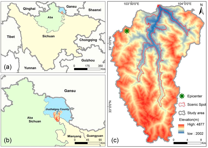
FIGURE 1. Geographical location of the study area. (A) Location of Jiuzhaigou in Sichuan Province. (B) Location of Jiuzhaigou in Jiuzhaigou County. (C) The study area in Jiuzhaigou.
The study area is the core site and corridor zone of the Minshan population of giant pandas and is a typical natural ecosystem. Because of the abundant animal and plant resources in the study area, species scarcity is outstanding and there is a high value of ecological protection, scientific research and esthetic tourism. However, Jiuzhaigou Scenic Area is located in an active crustal zone. Geohazards such as earthquakes, landslides and mudslides are frequent in Jiuzhaigou (Wang and Mao, 2022), which poses a great threat to the sustainable development of its ecosystem service functions.
The “7.26 mudslide” in 2016 and the “8.8 Jiuzhaigou earthquake” in 2017 both caused great damage to Jiuzhaigou’s infrastructure and ecological environment, and Jiuzhaigou’s tourism economy suffered a major blow as shown in Table 1. The data in Table 1 were derived from the national economic and social development statistical bulletin and statistical yearbook of Jiuzhaigou County. Because the earthquake epicenter was located at the core of the scenic area, the surrounding area of the scenic highway was seriously damaged by geohazards. According to statistics, 153 geohazards, including avalanches, mudslides, landslides, and unstable slopes, were developed in Jiuzhaigou Scenic Area because of the “8.8 Jiuzhaigou earthquake.”
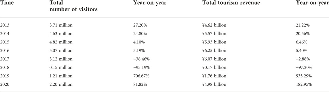
TABLE 1. Tourism economic statistics of Jiuzhaigou Scenic Area from 2013 to 2020.
After the “8.8 Jiuzhaigou earthquake,” the provincial government officially issued “the Overall Plan for the Recovery and Reconstruction of Jiuzhaigou” on November 4. Then, the Jiuzhaigou Administration invested 11.4 billion yuan and implemented a number of ecological restoration projects. The ecological restoration projects adopted the most advanced and environment-friendly technologies to repair 80% of the damaged area.
First, vibrofotation stone columns were used to reinforce the dam body and enhance the stability and bearing capacity of the dam. Second, the Jiuzhaigou administration used a Rock-Soil Anchoring Technique to reinforce the unstable part of the rock and soil. Third, Protophyta and sticky rice lime mortar were used to fill the dam body and restore its original plant ecological environment. Finally, the Jiuzhaigou administration adopted landscape design technology to restore the original landscape before the earthquake.
The study dataset mainly contains satellite images, topographic data, spectral index data and the resulting extracted land cover dataset. All spatial data were uniformly converted to the WGS_1984_UTM_48N coordinate system and the specific methodological data information is shown in Table 2.
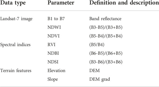
TABLE 2. Data and parameters.
The Landsat-7 images for the study period were obtained from the USGS and covered the period from 2013 to 2020. Referring to Global Land 30, Jiuzhaigou was divided into ten land cover types including agricultural land, forest, grass land, shrub, wetland, water body, construction land, barren land, snow, and ice (Newbold et al., 2015; Camara, 2020).
We obtained samples from high-definition images using manual annotation and used a random forest algorithm to automatically extract land cover information in Jiuzhaigou (Svoboda et al., 2022). Two hundred samples were divided into two groups with a ratio of 7:3 for training and validation of the random forest model. The input features of the samples included band reflectance, a spectral index, and topographic features, and the specific feature information is shown in Table 2. The spectral features were calculated from annual synthetic cloud-free images, and DEM data were obtained from SRTM with a spatial resolution of 30 m. We selected images whose cloud cover fraction was lower than 20% in the study area from 2013 to 2020. We made the median mosaic synthesis of the images year by year to obtain the annual cloud-free images of Jiuzhaigou from 2013 to 2020. A total of 42 images (Table 3) were used in this paper, and the average cloud cover fraction was 13.72. The random forest classifier was used in this paper and achieved an overall accuracy of 81% and a Kappa coefficient of 0.77.
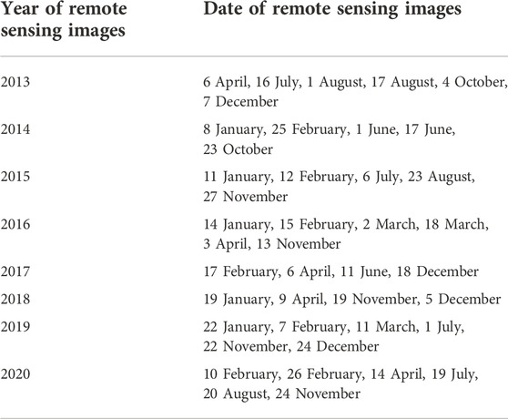
TABLE 3. Date of remote sensing images.
We used the raster of land cover types in the study area, the distance and weight between habitats and stressors, and the relative sensitivity of habitat types to stressors as input data (Terrado et al., 2016). We used the Habitat Quality module in the InVEST model to assess the quality of habitats in the study area.
The calculation formula is shown in Eq. 1:
In Eq. 1,
In Eqs 2–4,
Selecting specific land cover types as stressors that destroy habitat quality, we established a link between stressors and land cover types, and we evaluated the effects of land cover type change patterns on habitat quality in the study area under multiple time phases. The parameters mainly included the influence distance and weight of the stressors (Table 4) and habitat suitability and sensitivity of land cover types to the stressors (Table 5).
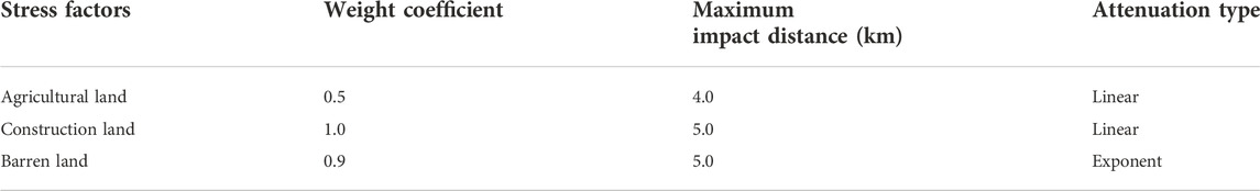
TABLE 4. Stress factors and their stress intensity.

TABLE 5. Sensitivity of land-use types to habitat stress factors.
In this paper, we selected eight landscape indicators (Table 6) to quantitatively analyze the landscape pattern of Jiuzhaigou Scenic Area and the nature reserve ecosystem from 2013 to 2020. All indicators reflected the spatial characteristics of the Jiuzhaigou landscape pattern including area, shape, degree of heterogeneity, and fragmentation of the landscape (Berglund et al., 2012; Haddad et al., 2015; Schroter and Remme, 2016).
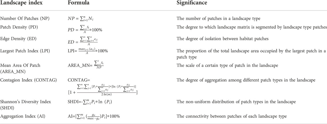
TABLE 6. Ecological landscape index and significance.
In Table 6,
The combination of Figure 2 and Table 7 shows that the land cover in Jiuzhaigou was mainly forest, grassland and shrub. The land cover also contains a variety of cover types such as wetland, water body, agricultural land, barren land, and snow and ice. The spatial distribution characteristics of Jiuzhaigou are related to the topography and altitude of the area. Overall, the scenic area had fewer land cover types, mainly forest and water body, which have slowly changed. The nature reserve had a full range of cover types that are under the pressure of geohazards, and its land cover interchanged among forest, grassland, shrub, and barren land.
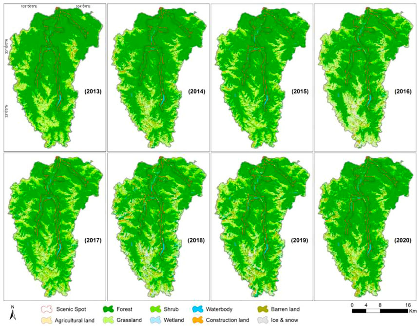
FIGURE 2. Spatio-temporal presentation of land cover in Jiuzhaigou.
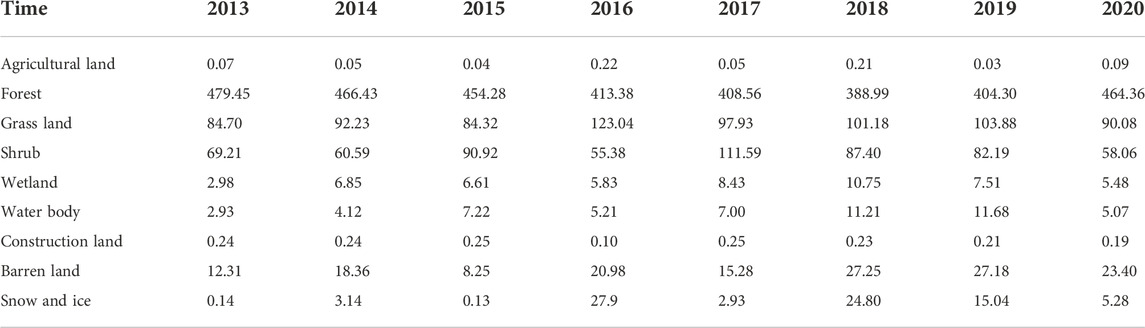
TABLE 7. Change of land cover area in Jiuzhaigou (
Figures 3 and 4 represent the main land cover changes in Jiuzhaigou Nature Reserve and Scenic Area during the study period. With the continuous development of tourism in Jiuzhaigou and a breakthrough in the number of tourists year after year (Table 1), the forest area continuously declined from 2013 to 2018. As of 2016, the forest area in the scenic area decreased 3.705
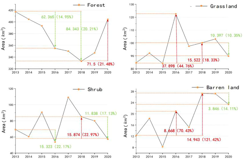
FIGURE 3. Main land cover changes in the Jiuzhaigou Nature Reserve.
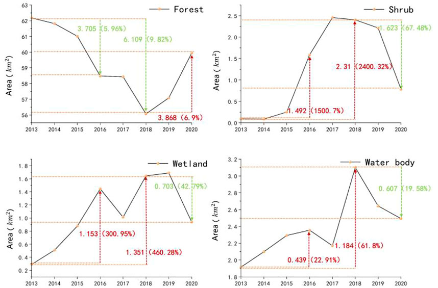
FIGURE 4. Main land cover changes in Jiuzhaigou Scenic Area.
In Figure 5, the forest in the scenic area landscape was converted to shrub, wetland, and water body during the study period due to geohazard stresses. As of 2016, shrub increased by 1.492

FIGURE 5. Spatial and temporal variation of main cover types in Jiuzhaigou Scenic Area: change in (A,D,G,J) shrub area, (B,E,H,K) wetland area, and (C,F,I,L) waterbody area.
The nature reserve is a vast area with a wide variety of cover, and damaged forest was converted to shrub, grassland, and barren land, while other cover types did not significantly change. Compared with the change of cover types in the scenic area, the increase of barren land in the nature reserve was most noteworthy. Up to 2016 and 2018, the area of barren land increased by 8.668 and 14.943
In Figure 6, the habitat quality service function in Jiuzhaigou from 2013 to 2020 showed obvious spatial differentiation characteristics. The high value areas of habitat quality service were mainly distributed along tourist attractions and surrounding areas, which had a vast area of forest (Table 2), perfect ecological protection measures and few habitat threat factors. The low value of habitat quality service was concentrated in the south of Jiuzhaigou, which had sparse vegetation cover and frequent geohazards. It was difficult to achieve systematic human management due to the high altitude, which has maintained the original ecology for a long time.
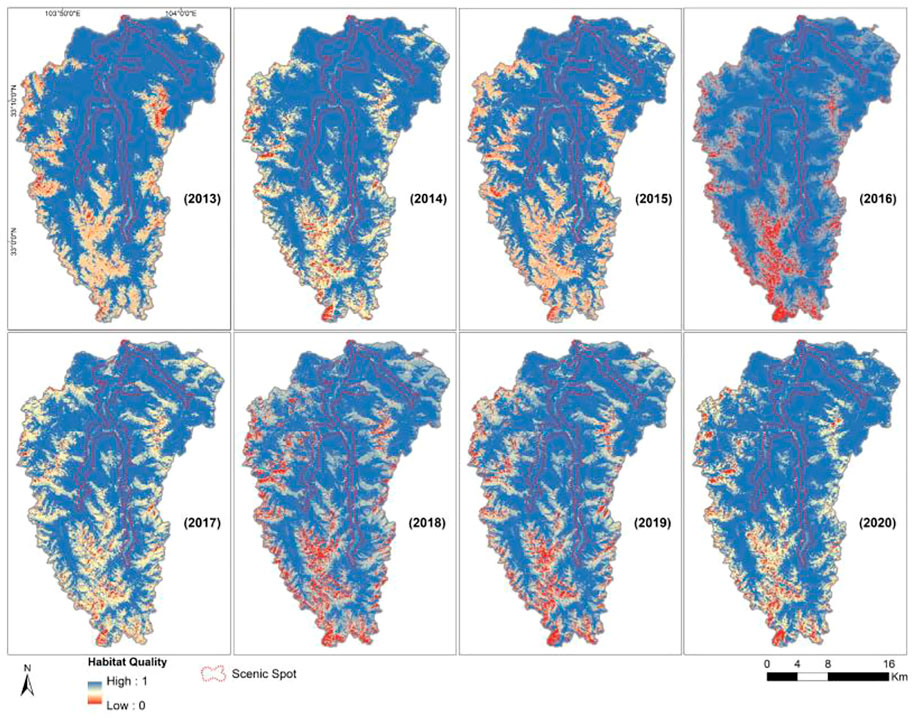
FIGURE 6. Spatio-temporal changes of habitat quality in Jiuzhaigou.
The habitat quality service function of Jiuzhaigou during the study period was divided into a declining period (2013–2018) and a recovery period (2019–2020). Both the “7.26 mudslide” in 2016 and the “8.8 Jiuzhaigou earthquake” in 2018 caused serious damage to the habitat quality service function of Jiuzhaigou, and its habitat quality index decreased significantly in 2016 and 2018. The “8.8 Jiuzhaigou earthquake” extensively affected the whole area of Jiuzhaigou, and the “7.26 mudslide” mainly affected the southern high-altitude area of the Jiuzhaigou Nature Reserve. This showed that habitat quality responded differently to different geohazard types and intensities. Different measures should be implemented for different types of geohazards.
Figure 7 and Table 8 show that between 2013 and 2020, the nature reserve and overall regional habitat quality index changed in a similar trend. Influenced by geohazards and compared with the previous year, the habitat quality index of the nature reserve decreased by 7.99% in 2016 and by 5.69% in 2018. Therefore, the frequency of geohazards was the main factor that limited the habitat stability of Jiuzhaigou.
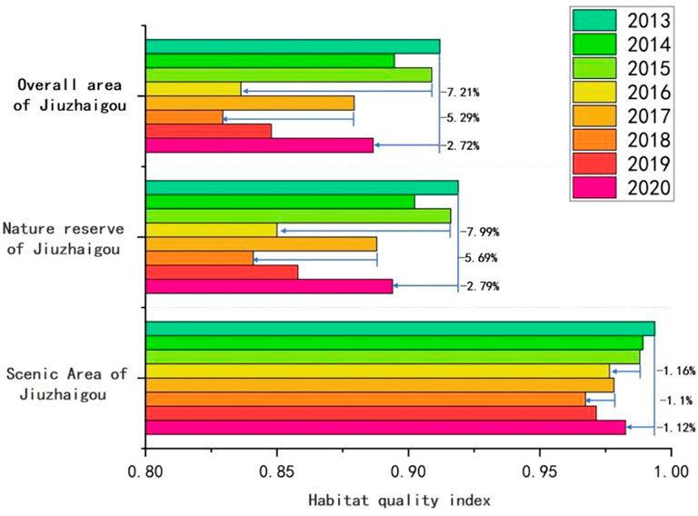
FIGURE 7. Temporal variation of the Habitat Quality Index in Jiuzhaigou.
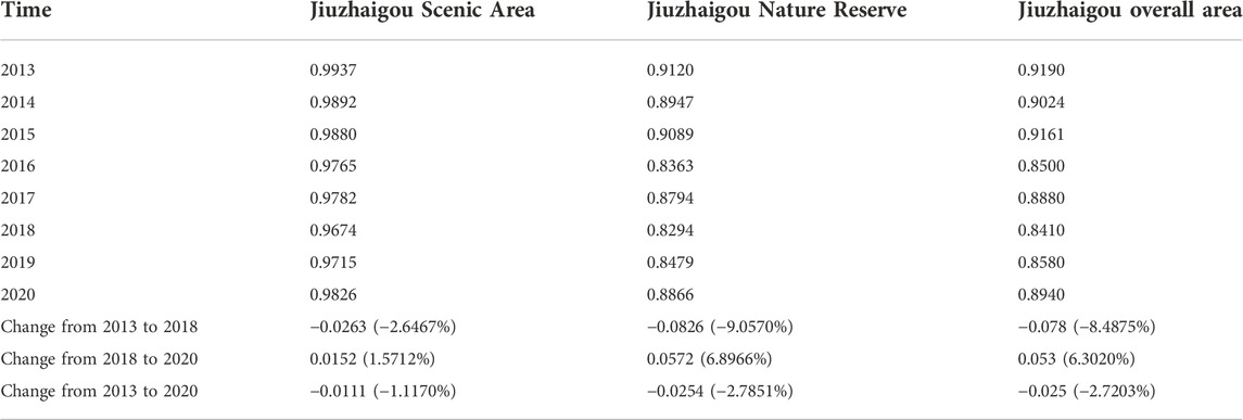
TABLE 8. The change of the Habitat Quality Index in Jiuzhaigou from 2013 to 2020.
Under a guarantee of ecological restoration projects and the geohazards warning system, the impact of geohazards on the habitat quality of Jiuzhaigou Scenic Area was limited. Compared with the previous year, the habitat quality index of Jiuzhaigou Scenic Area decreased by 1.16% in 2016 and by 1.1% in 2018. Compared with the highest value of habitat quality in 2013, the nature reserve decreased 2.79% and the scenic area decreased 1.12% during the study period, which indicated that standardized management played a positive role in the recovery of ecological functions after geohazards. In a similar study, Mengist Wondimagegn used the InVEST model to assess habitat quality in the Kaffa biosphere reserve (Mengist et al., 2021). According to the comparison, the habitat quality index of the unmanaged biosphere reserve in the natural state decreased by 3% from 2009 to 2019, which was also much higher than the 1.12% decline of Jiuzhaigou Scenic Area in this paper.
Figure 8 shows that Heye Stockade, Sparking Lake, and Five-Flower Lake are the most famous attractions in Jiuzhaigou Scenic Area, and they are typical areas for human-managed ecological restoration. Comparing the overall area map and local map in Figure 7, we can see that many low habitat quality areas occurred in scenic areas in 2018 and they slowly disappeared until 2020. Therefore, to maintain the ecological service function of Jiuzhaigou, it is necessary to scientifically and legally manage the ecological environment of the scenic area, strengthen the construction and protection of the woodland, improve the overall quality of the ecological land, and thus improve the overall quality of habitat in the watershed.
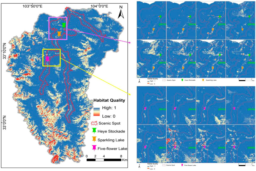
FIGURE 8. Change of the Habitat Quality Index of the area of ecological restoration projects.
Figure 9 shows that the “8.8 Jiuzhaigou earthquake” in 2018 caused serious damage to Five-Flower Lake. From this, we can clearly see the huge destructive power of geohazards and the positive effect of ecological restoration projects.

FIGURE 9. Change of Five-Flower Lake: (A) before the earthquake, (B) after the earthquake, and (C) after the ecological restoration projects.
According to Tables 9 and 10, the number and density of patches in both the scenic area and nature reserve increased significantly during 2013–2018, while they decreased in 2019–2020. Similarly, the mean area of the patch and the largest patch index also showed a similar trend. However, the decrease of the mean area of the patch also led to an increase in the patch edge density. The degree of isolation between the plaques significantly increased. As a whole, the change of the ecological landscape pattern fragmentation degree took a turning point in 2018. The landscape fragmentation of the scenic area was more serious compared with the nature reserve and its landscape fragmentation phenomenon was alleviated in 2019–2020. Therefore, the internal connectivity and stability of the landscape of the scenic area was improved by implementation of standardized management and ecological restoration projects.
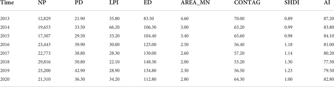
TABLE 9. Ecological Landscape Index of Jiuzhaigou Nature Reserve from 2013 to 2020.
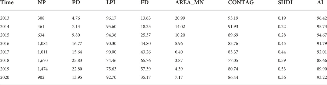
TABLE 10. Ecological Landscape Index of Jiuzhaigou Scenic Area from 2013 to 2020.
In the above tables, the aggregation index and contagion index of the scenic area showed a decreasing and then increasing trend, and the values were higher than the nature reserve. Under the effect of standardized management, the scenic area had a faster recovery ability of fragmented landscape, which facilitated the formation of highly connected dominant patches. In addition, the Shannon’s diversity index directly represented landscape heterogeneity, and the diversity index of Jiuzhaigou Nature Reserve was relatively stable, while the landscape diversity index of scenic area showed an obvious trend of first increasing and then decreasing.
The evaluation results based on the InVEST model in this study directly and accurately revealed the Spatio-temporal evolution of habitat quality in Jiuzhaigou from 2013 to 2020.
1) The overall habitat quality index of the study area decreased significantly from 2013 to 2018 and recovered from 2019 to 2020. As of 2020, the nature reserve habitat quality index recovered to 97.21% of its highest value (2013), and the scenic habitat quality index recovered to 98.88% of its highest value (2013). Therefore, the ecological restoration projects effectively contributed to the restoration of habitat quality after geohazards.
2) The maximum decrease in scenic habitat quality compared to the early stage of the study (2013) was 2.65%, while the maximum decrease in nature reserve habitat quality compared to the early stage of the study (2013) was 9.06%. Thus, the ecological restoration projects effectively suppressed the damage of geohazards to the ecological environment of the scenic area.
3) Jiuzhaigou Scenic Area is mainly involved in tourism and cultural dissemination activities. The land cover type in the area was relatively homogeneous and mainly forest and water body. Therefore, the habitat quality in the scenic area was superior and stable. The landscape of scenic area is more likely to break but it had a stronger recovery ability than the nature reserve. The main way to improve the habitat quality and optimize the spatial pattern of the landscape was to restore the forest cover type.
The raw data supporting the conclusion of this article will be made available by the authors without undue reservation.
HS: methodology, writing—original draft, and writing—review and editing. CL: conceptualization, writing—review and editing, supervision, and funding acquisition. CY: writing—review and editing. XX and TS: investigation and visualization.
This work was supported in part by the Second Tibetan Plateau Scientific Expedition and Research Program (2019QZKK0902), the National Natural Science Foundation of China (42071411), the key research and development program of Sichuan Province (2022YFG0200), the project “Research on the Integrated Development of Sports City and Agriculture, Commerce, Culture, and Tourism in Chengdu (CDMC 2021B05),” which is from the Research Center for Philosophy and Social Sciences of Chengdu (Chengdu Research Center for World Championship City), and the project “Research on Rural Ecological Cultural Landscape in the View of Rural Revitalization (JGYQ2022008),” which is from the Sichuan Landscape and Recreation Research Center (Research Base of Humanities and Social Sciences of Sichuan Provincial Department of Education).
The authors declare that the research was conducted in the absence of any commercial or financial relationships that could be construed as a potential conflict of interest.
All claims expressed in this article are solely those of the authors and do not necessarily represent those of their affiliated organizations, or those of the publisher, the editors, and reviewers. Any product that may be evaluated in this article, or claim that may be made by its manufacturer, is not guaranteed or endorsed by the publisher.
Aneseyee, A. B., Soromessa, T., and Elias, E. (2020). The effect of land use/land cover changes on ecosystem services valuation of Winike watershed, Omo Gibe basin, Ethiopia. Hum. Ecol. Risk Assess. Int. J. 26, 2608–2627. doi:10.1080/10807039.2019.1675139
Berglund, M., Jacobi, M. N., and Jonsson, P. R. (2012). Optimal selection of marine protected areas based on connectivity and habitat quality. Ecol. Modell. 240, 105–112. doi:10.1016/j.ecolmodel.2012.04.011
Camara, G. (2020). On the semantics of big Earth observation data for land classification. J. Spat. Inf. Sci., 21–34. doi:10.5311/JOSIS.2020.20.645
Ding, Q., Chen, Y., Bu, L., and Ye, Y. (2021). Multi-scenario analysis of habitat quality in the yellow river delta by coupling FLUS with InVEST model. Int. J. Environ. Res. Public Health 18, 2389. doi:10.3390/ijerph18052389
Haddad, N. M., Brudvig, L. A., Clobert, J., Davies, K. F., Gonzalez, A., Holt, R. D., et al. (2015). Habitat fragmentation and its lasting impact on Earth’s ecosystems. Sci. Adv. 1, e1500052. doi:10.1126/sciadv.1500052
Hu, W., Li, G., Gao, Z., Jia, G., Wang, Z., and Li, Y. (2020). Assessment of the impact of the Poplar Ecological Retreat Project on water conservation in the Dongting Lake wetland region using the InVEST model. Sci. Total Environ. 733, 139423. doi:10.1016/j.scitotenv.2020.139423
Li, M., Zhou, Y., Xiao, P., Tian, Y., Huang, H., and Xiao, L. (2021). Evolution of habitat quality and its topographic gradient effect in northwest hubei province from 2000 to 2020 based on the InVEST model. Land 10, 857. doi:10.3390/land10080857
Liu, G. Y., Wang, P., and Xie, H. L. (2013). Analysis of ecological landscape pattern change in the Poyang Lake eco-economic zone of China. Adv. Mat. Res. 864–867, 2639–2644. doi:10.4028/www.scientific.net/AMR.864-867.2639
Liu, Z., Qiu, H., Zhu, Y., Liu, Y., Yang, D., Ma, S., et al. (2022). Efficient identification and monitoring of landslides by time-series InSAR combining single- and multi-look phases. Remote Sens. (Basel). 14, 1026. doi:10.3390/rs14041026
Maes, J., Paracchini, M. L., Zulian, G., Dunbar, M. B., and Alkemade, R. (2012). Synergies and trade-offs between ecosystem service supply, biodiversity, and habitat conservation status in Europe. Biol. Conserv. 155, 1–12. doi:10.1016/j.biocon.2012.06.016
Maingi, J. K., and Marsh, S. E. (2001). Assessment of environmental impacts of river basin development on the riverine forests of eastern Kenya using multi-temporal satellite data. Int. J. Remote Sens. 22, 2701–2729. doi:10.1080/01431160010031298
Melzer, M., and Bellingrath-Kimura, S. (2021). GIS-based modeling of ecosystem services - status quo, potentials and trade-offs [GIS-gestützte Modellierung von ökosystemleistungen – status quo, Potenziale und Trade-offs] [WWW Document]. Available at https://schlr.cnki.net/en/Detail/index/GARJ2021_2/XQSP2171699C460C6EA617478B242A25D769 (accessed 22 10, 22).
Mengist, W., Soromessa, T., and Feyisa, G. L. (2021). Landscape change effects on habitat quality in a forest biosphere reserve: Implications for the conservation of native habitats. J. Clean. Prod. 329, 129778. doi:10.1016/j.jclepro.2021.129778
Newbold, T., Hudson, L. N., Hill, S. L. L., Contu, S., Lysenko, I., Senior, R. A., et al. (2015). Global effects of land use on local terrestrial biodiversity. Nature 520, 45–50. doi:10.1038/nature14324
Qiu, H., Zhu, Y., Zhou, W., Sun, H., He, J., and Liu, Z. (2022). Influence of DEM resolution on landslide simulation performance based on the Scoops3D model. Geomat. Nat. Hazards Risk 13, 1663–1681. doi:10.1080/19475705.2022.2097451
Schroter, M., and Remme, R. P. (2016). Spatial prioritisation for conserving ecosystem services: Comparing hotspots with heuristic optimisation. Landsc. Ecol. 31, 431–450. doi:10.1007/s10980-015-0258-5
Sowinska-Swierkosz, B. (2017). Application of surrogate measures of ecological quality assessment: The introduction of the Indicator of Ecological Landscape Quality (IELQ). Ecol. Indic. 73, 224–234. doi:10.1016/j.ecolind.2016.09.019
Svoboda, J., Stych, P., Lastovicka, J., Paluba, D., and Kobliuk, N. (2022). Random forest classification of land use, land-use change and forestry (LULUCF) using sentinel-2 data-A case study of Czechia. Remote Sens. (Basel). 14, 1189. doi:10.3390/rs14051189
Terrado, M., Sabater, S., Chaplin-Kramer, B., Mandle, L., Ziv, G., and Acuna, V. (2016). Model development for the assessment of terrestrial and aquatic habitat quality in conservation planning. Sci. Total Environ. 540, 63–70. doi:10.1016/j.scitotenv.2015.03.064
Van Vooren, L., Reubens, B., Broekx, S., Reheul, D., and Verheyen, K. (2018). Assessing the impact of grassland management extensification in temperate areas on multiple ecosystem services and biodiversity. Agric. Ecosyst. Environ. 267, 201–212. doi:10.1016/j.agee.2018.08.016
Wang, L., Qiu, H., Zhou, W., Zhu, Y., Liu, Z., Ma, S., et al. (2022). The post-failure spatiotemporal deformation of certain translational landslides may follow the pre-failure pattern. Remote Sens. (Basel). 14, 2333. doi:10.3390/rs14102333
Wang, X., and Mao, H. (2022). Spatio-temporal evolution of post-seismic landslides and debris flows: 2017 M-S 7.0 Jiuzhaigou earthquake. Environ. Sci. Pollut. Res. 29, 15681–15702. doi:10.1007/s11356-021-16789-9
Wu, L., Sun, C., and Fan, F. (2021). Estimating the characteristic spatiotemporal variation in habitat quality using the InVEST model-A case study from guangdong-Hong Kong-Macao greater bay area. Remote Sens. (Basel). 13, 1008. doi:10.3390/rs13051008
Keywords: Jiuzhaigou tourist scenic, ecosystem services, ecological restoration project, InVEST model, geohazards
Citation: Sui H, Liu C, Ye C, Xu X and Sui T (2023) Analysis of ecosystem resilience in Jiuzhaigou Valley Scenic Area under the effect of geohazards. Front. Earth Sci. 10:1053327. doi: 10.3389/feart.2022.1053327
Received: 25 September 2022; Accepted: 02 November 2022;
Published: 18 January 2023.
Edited by:
Haijun Qiu, Northwest University, ChinaReviewed by:
Li Shen, Southwest Jiaotong University, ChinaCopyright © 2023 Sui, Liu, Ye, Xu and Sui. This is an open-access article distributed under the terms of the Creative Commons Attribution License (CC BY). The use, distribution or reproduction in other forums is permitted, provided the original author(s) and the copyright owner(s) are credited and that the original publication in this journal is cited, in accordance with accepted academic practice. No use, distribution or reproduction is permitted which does not comply with these terms.
*Correspondence: Chang Liu, MTAwNDUyNjYzMkBxcS5jb20=
Disclaimer: All claims expressed in this article are solely those of the authors and do not necessarily represent those of their affiliated organizations, or those of the publisher, the editors and the reviewers. Any product that may be evaluated in this article or claim that may be made by its manufacturer is not guaranteed or endorsed by the publisher.
Research integrity at Frontiers
Learn more about the work of our research integrity team to safeguard the quality of each article we publish.