 Caiming Shen
 Kam-biu Liu
 Lingyu Tang
 Jinlan Peng3
94% of researchers rate our articles as excellent or good
Learn more about the work of our research integrity team to safeguard the quality of each article we publish.
Find out more
ORIGINAL RESEARCH article
Front. Earth Sci. , 05 January 2023
Sec. Quaternary Science, Geomorphology and Paleoenvironment
Volume 10 - 2022 | https://doi.org/10.3389/feart.2022.1025552
This article is part of the Research Topic Integration of Records and Simulations in Paleoclimatology View all 7 articles
A 101-cm core was taken from a large lake in the central Tibetan Plateau. Its pollen and loss-on-ignition analyses provide a Holocene vegetational, climatic, and environmental history of the lake catchment. Pollen analysis shows that: dense steppe dominated regional vegetation in the early Holocene (9,200–8,000 cal. yr BP); regional vegetation coverage gradually decreased in the middle Holocene (8,000–4,100 cal. yr BP); and marsh meadow grew on the lake edge and sparse steppe occupied the lake catchment after 4,100 cal. yr BP. Our result also reveals that: 9,200–8,000 cal. yr BP witnessed summer temperature, monsoonal rainfall, and lake-level maxima, as well as few winter and spring aeolian activities and frequent wildfires; 8,000–4,100 cal. yr BP saw a nonlinear decline in temperature, rainfall, lake level, and wildfires; and modern climatic and environmental conditions were established after 4,100 cal. yr BP. Three major monsoon-weakening events at ca. 6,700, 5,800, and 4,100 cal. yr BP were detected by pollen signals and proxies of the climate and environment.
As the “Asian water tower,” the Tibetan Plateau (TP) not only regulates the hydro-climatology to supply adequate water for those prominent Asian rivers such as the Yangtze River, Ganges–Brahmaputra River, and Mekong River, but also provides life-sustaining water for a large portion of the world’s population (Immerzeel et al., 2010). Recent long Indian summer monsoon (ISM) records on the Indian continental margin suggest stronger monsoon rainfall in the future (Clemens et al., 2021), and a 1,656-year mean annual precipitation record in the TP interior also suggests that such high precipitation may continue in the next several decades (Cui et al., 2021). However, observational evidence and model projections indicate an imbalance in the Asian water tower associated with the westerlies and the Indian monsoon, and the future of the Asian water tower thus remains highly uncertain (Yao et al., 2022). Therefore, advanced climate models, which require the detailed understanding of past Indian monsoon dynamics and the interplay between the monsoon and westerlies, are essential for accurate predictions of future water supply.
The TP is a huge highland at 4,000–4,500 m above sea level (a.s.l.) in the Eurasian continent. Its great area with various alpine vegetation types is unique in the world (Zhang, 1978). Since the TP is a huge and elevated heat source, this alpine ecosystem of the TP is important for the energy flux between the land surface and the atmosphere (Shen et al., 2015). Any changes in land surface will alter its albedo, and thus have impacts on the radiation budgets and feedbacks of the TP (Wang, 2006). On the other hand, the advanced climate models mentioned previously also require high spatial and temporal resolution land surface (Brown et al., 2018; Maclean, 2019). Land-surface conditions, especially vegetation, during the Pleistocene and Holocene have been studied extensively (Chen et al., 2020; Tang et al., 2021). However, more well-dated data of high spatial-temporal resolution land surface are needed to understand the feedback mechanism of the vegetation and carbon cycle in the TP (Hua et al., 2019; Mu et al., 2020) and to provide detailed landscape maps for the precise prediction of climate model simulations (Wang et al., 2014).
As transitional zones between adjacent ecological systems, ecotones are sensitive to environmental changes (Holland et al., 1991; Kullman et al., 1990). Many studies have indicated that the vegetational and climatic history of fossil sites along and near the ecotones can provide detailed information about past vegetation and climate (e.g. Liu, 1990; Reasoner and Jodry 2000; Nelson et al., 2004; Mancini, 2009; Shumilovskikh et al., 2018). A series of ecotones, such as forest-meadow, meadow-steppe, and steppe-desert, exist in the vast area of the TP (Wang et al., 2022). In the central TP, the meadow-steppe ecotone (MSE) roughly follows the 400 m isohyet. The dominant species of steppe and meadow can be found in both steppes and meadows. Fossil pollen records along and near this ecotone have revealed the vegetational and climatic dynamics during the Holocene (Herzschuh et al., 2006; Shen et al., 2008a; Tang et al., 2009). This study presents a pollen record from Xuguo Co (“Co” means lake in Tibetan) near the MSE to reconstruct the Holocene vegetational and climatic history of its catchment in the central TP.
Xuguo Co (31°57′N, 90°20′E; 4,595 m a.s.l.) is a large lake with an area of 22.7 km2, located in the interior of the steppe region near the MSE, geographically between Nagqu and Baingo (Figure 1). It is a brackish lake with a maximum water depth of 3.5 m. Several streams flow into the lake, and its catchment area is about 975 km2 (Wang and Du, 1998). The catchment of Xuguo Co has a cold semi-arid climate (Figure 2). The mean annual temperature is −1.4 to −0.9°C, with the lowest and highest monthly temperatures of −13.1 to −11.2°C in January and 8.5 to 9.0°C in July, respectively. The annual mean precipitation is 300–400 mm, mostly brought about by the ISM. About 90% of the annual precipitation is concentrated in the months of May to September.
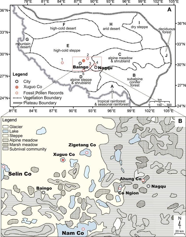
FIGURE 1. (A) Map of the Tibetan Plateau showing the vegetation, locations of Xuguo Co, and main fossil records cited in this study (1. Selin Co; 2. Zigetang Co; 3. Co Ngion; 4. Ahung Co; 5. Nam Co). (B) Regional vegetation in the central Tibetan Plateau.
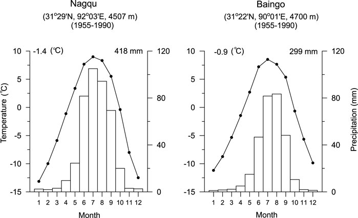
FIGURE 2. Summary of regional climate; lines are temperature and bars are precipitation.
Three vegetation types, i.e., high-cold steppe, alpine meadow, and marsh meadow, occur in the study region (Figure 1B). High-cold steppe vegetation grows on the Qiangtang Plateau west of the MSE. Alpine meadows occupy the vast region east of the MSE. Marsh meadows can be found in wetlands over steppes and alpine meadows. The Stipa purpurea community is the typical steppe vegetation with a coverage of about 20–40%. Its accompanying species are Artemisia wellbyi, Astragalus heydei, Carex montis-everestii, Dracocephalum heterophyllum, Festuca ovina, Kobresia macrantha, Leontopodium pusillum, Oxytropis tatarica, and Poa litwinowiana (Wang, 1988). The Kobresia pygmaea community, the most widely distributed alpine meadow vegetation in the TP, occurs on the landscapes east of the ecotone. Its coverage is about 60–90%. In addition to the dominant species Kobresia pygmaea, commonly found species include Cyperaceae species such as K. humilis, K. royleana, and K. prainii, as well as Poaceae species such as Carex moorcroftii, Poa calliopsis, and Stipa purpurea, and other species such as Leontopodium nanum, Potentilla bifurca, Thalictrum alpinum, and Polygonum macrophyllum. In the lowlands of lake basins are marsh meadows, which consist of Kobresia littledalei, K. royleana, K. pygmaea, Carex satakeana, C. moorcroftii, Blysmus sinocompressus, and B. compressus (Tibetan Investigation Group, 1988).
A 101-cm piston core was taken from the center of Xuguo Co under 3.5 m of water in the summer of 1999 (Figure 1). Subsamples of 0.9 cc were extracted at 2-cm intervals. Loss-on-ignition (LOI) analysis was conducted at 105°C, 550°C, and 1,000°C to determine the percentages of water, organic matter, and carbonates in the sediments, respectively (Dean, 1974). AMS-dating of four bulk organic samples (Table1) was conducted at the AMS Laboratory, University of Arizona. Pollen samples were processed and counted using the standard method involving HCl, KOH, HF, and acetolysis treatment (Faegri and Iversen, 1975). Tablets containing a known quantity of Lycopodium spores were added as exotic markers into the samples to determine pollen concentrations and pollen influx values (Stockmar, 1971). More than 400 pollen grains, excluding spores and algal colonies, were counted at each level. Pollen percentages were calculated based on a sum of all terrestrial plant pollen. Charcoal particles were also counted at each level. The discriminant functions developed using 227 surface samples (Shen et al., 2008b; Shen et al., 2021) were applied to reconstruct past vegetation.
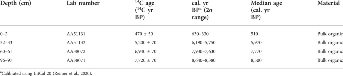
TABLE 1. Radiocarbon dates for the Xuguo Co core.
The 101-cm core from Xuguo Co is composed of clayey silt. Three lithological units can be recognized based on the results of LOI (Figure 3). The 101–43 cm unit contains moderate organic and carbonate matter as well as low minerogenic matter (66.4–76.6/70.1%, minimum-maximum/average). Organic matter fluctuates between 13.5 and 21.6% with an average of 17.2%, and carbonate matter varies between 9.6 and 17.4% with an average of 13.8%. The lowest organic matter content (7.8–14.5/11.6%) of the whole core occurs at the depth of 43–19 cm, where the carbonate content shows two cycles from low (ca. 10%) to high (ca. 18%) values. This unit also contains three peaks of minerogenic matter. The upper 19-cm sediments consist of low carbonate content (6.3–10.9/9.4%) and high organic matter content (13.6–20.9/17.7%).
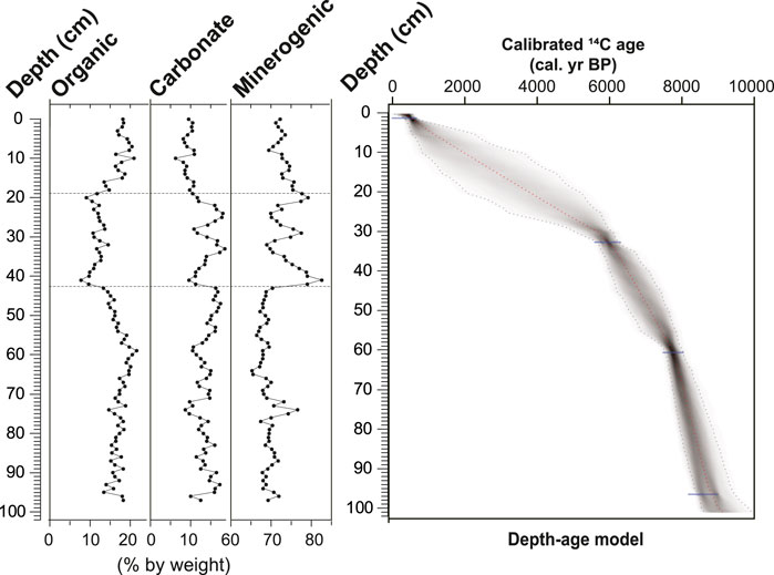
FIGURE 3. Results of loss-on-ignition analysis and depth-age model for the Xuguo Co core.
The radiocarbon date at the top (0–2 cm) of the Xuguo Co core is 470 ± 50 14C yr BP, close to the modern date (Table 1), implying that the lake has very small or no reservoir effect, which is negligible. Even if the lake has some reservoir effect, it would have been less than a couple of hundred years and within the 2σ error range of radiocarbon dates. Therefore, the 14C dates used to build the age-depth model of the Xuguo Co core (Figure 3) are not corrected by any reservoir age, but it should be pointed out that the age of each level might have a reservoir age less than a couple of hundred years. The age-depth model shows that the upper part of the core has a lower sedimentary rate than the lower part. The low sedimentary rate in the late Holocene is probably attributed to regional hydrological changes caused by climate variations such as a weakened summer monsoon.
The pollen spectra from Xuguo Co are dominated by herbaceous pollen (91–99%), mainly including Poaceae, Artemisia, Cyperaceae, Ranunculaceae, Thalictrum, Asteraceae, Chenopodiaceae, Caryophyllaceae, Leguminosae, and Polygonum. The arboreal pollen contains mainly grains of Hippophae, Betula, Pinus, and Alnus, along with isolated grains of Abies, Picea, Quercus, Ulmus, Salix, Potentilla, and Caragana. The occurrence of tree pollen is apparently due to long-distance transport. The shrubs such as Hippophae, Potentilla, and Caragana may come from local vegetation. The pollen record from Xuguo Co is divided into four pollen zones (Figure 4):
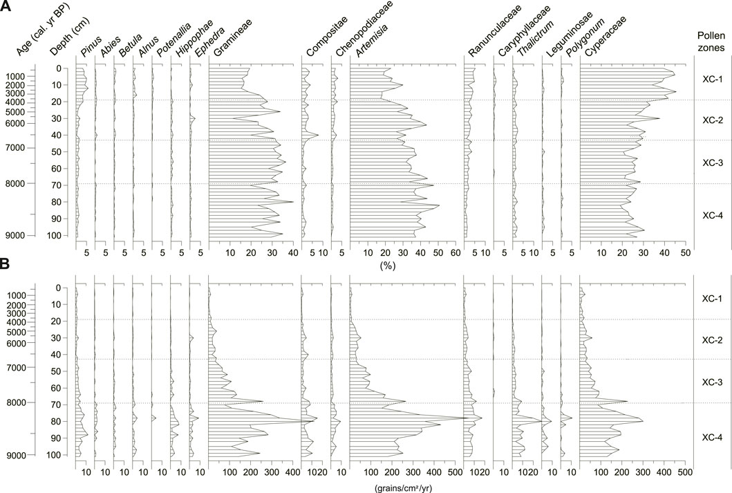
FIGURE 4. Pollen percentage diagram (A) and pollen influx diagram (B) for the Xuguo Co core.
Zone XC-4 (101–69 cm; 9,200 to 8,000 cal. yr BP): This basal pollen zone is characterized by the highest pollen influx values and relatively frequent fluctuations in pollen percentages of Artemisia and Poaceae. Poaceae pollen percentages vary between 20.1 and 40.2% with an average of 29.0%, while Artemisia pollen percentages fluctuate between 28.5 and 50.8% with an average of 39.9%, showing a reciprocal trend to each other. This zone has the lowest percentages of Cyperaceae (18.9–30.6/23.9%, minimum-maximum/average, the same as below). Thalictrum, Asteraceae, and Rannunculaceae are relatively common. Pollen percentages of Chenopodiaceae are less than 1%.
Zone XC-3 (69–31 cm; 8,000 to 5,800 cal. yr BP): Pollen influx values steadily and nonlinearly decrease in this zone. Cyperaceae pollen (20.5–31.0/25.8%) increases slightly, whereas pollen percentages of Artemisia (26.2–44.0/34.7%) decrease. Poaceae pollen (19.8–36.5/30.5%) is consistently and abundantly represented throughout this zone, reaching its maximum for the whole core. Asteraceae, Chenopodiaceae, and Thalictrum pollen is present in small amounts. No significant changes occur among the other pollen types.
Zone XC-2 (31–19 cm; 5,800 to 3,600 cal. yr BP): This zone is marked by an increase in pollen percentages of Cyperaceae and a decrease in Poaceae pollen. Artemisia pollen (23.2–35.3/30.2%) shows a significant nonlinear decreasing trend. Pollen percentages of Poaceae (11.2–33.9/25.1%) decrease to its minimum value (11.2%) for the whole core, and then rise again but still are lower than those in the preceding zones. Cyperaceae pollen shows an increasing trend. Pollen influx values for most pollen types except Asteraceae are lower in this zone than the preceding zone.
Zone XC-1 (19–0 cm; 3,600 cal. yr BP to the present): This zone is distinguished from zone XC-2 by the minima of Poaceae and Artemisia pollen (17.4–30.3/21.8% and 15.3–27.8/19.7%, respectively), and the maximum of Cyperaceae pollen (31.5–45.6/40%). Rannunculaceae pollen is common. Pollen percentages of Asteraceae, Chenopodiaceae, and Thalictrum are roughly the same as those in zone XC-2. The pollen of Polygonum, Caryophyllaceae, and Ephedra is present in small amounts, but more than that in zone XC-2. Long-distance-transported tree pollen, such as Pinus, Alnus, Betula, and Abies, reaches its maximum, among which Pinus pollen (3.1–5.8/4.0%) is the largest.
As shown by Figure 4, the fossil pollen spectra of Xuguo Co are dominated by Poaceae, Artemisia, and Cyperaceae, three constructive taxa of alpine meadow, alpine steppe, and marsh meadow regions. The Artemisia/Cyperaceae (A/Cy) ratio was introduced by Herzschuh et al. (2006) as a proxy of summer temperature when they interpreted the fossil pollen spectra of Zigetang Co, near Xuguo Co. This interpretation has been supported by modern pollen spectra (Yu et al., 2001; Shen et al., 2006, 2021; Lu et al., 2011). Positive (negative) relationships between Artemisia (Cyperaceae) pollen percentages and July temperature have been observed in modern pollen spectra (Shen et al., 2006). We thus follow Herzschuh et al. (2006) in using this Artemisia/Cyperaceae ratio as a proxy of summer temperature in the interpretation of the fossil pollen record of Xuguo Co.
The Artemisia/Chenopodiaceae pollen ratio (A/C) was used as a proxy of atmospheric or soil moisture in the highly stressed environment of the high desertic TP (Van Campo and Gasse, 1993; Liu et al., 1998). However, the A/C ratio cannot be used as an indicator of moisture due to the very low percentages of Chenopodiaceae pollen in the steppe and meadow regions, especially close to MSE. A candidate for a moisture proxy in the steppe and meadow region is the Poaceae/Artemisia (G/A) pollen ratio. Poaceae and Artemisia are the two dominant pollen types for the Xuguo Co pollen record. In the central TP, the Artemisia pollen mainly comes from Artemisia wellbyi, A. minor, A. moorcroftiana, and A. desertorum, whereas the Poaceae pollen mainly comes from Stipa purpurea, S. basiplumosa, S. roborowskyi, S. glareosa, Festuca ovina, Carex montis-everestii, C. moorcroftii, Poa litwinowiana, and P. crymophila (Tibetan Investigation Group, 1988; Wang, 1988). Ecologically, sage communities are more characteristic of drier and more open condition than grass communities (Tibetan Investigation Group, 1988). Data from the surface samples with abundant Artemisia and Poaceae pollen also suggest the existence of such a relationship. G/A ratios rise with the increase of moisture in July. A power fit shows that the positive correlation between G/A ratio and moisture in July is statistically significant at the 0.01 level (Shen, 2003). It is thus reasonable to use the G/A ratio as an indicator of atmospheric or soil moisture availability for fossil pollen records from the steppe and meadows regions.
In the central TP, Cyperaceae is a dominant species both in alpine and marsh meadows (Figure 1B). Cyperaceae pollen derived from the former reflects the signature of regional vegetation, whereas its pollen from the latter reflects the composition of local vegetation. Due to the lake edge habitat being favorable to marsh vegetation, it is difficult to separate Cyperaceae pollen from these two different origins in the lake pollen records (Sun et al., 1993). If Cyperaceae pollen is derived from local marsh meadow, a lower lake level or drier conditions would be indicated by a rise in Cyperaceae pollen as the lake dries up and the lake edge habitats move closer to the coring site. Given the location of Xuguo Co and the vegetation (alpine steppe) reconstructed by the Holocene fossil pollen record from Zigetang Co, most of the Cyperaceae pollen is derived from marsh meadow instead of alpine meadow. Therefore, we use Cyperaceae pollen percentage as a lake-level proxy, i.e., more Cyperaceae pollen means a lower lake level.
Pollen influx is an important parameter of Quaternary pollen analysis. The computation of pollen influx (grain/cm2/year) overcomes the numerical problems of percentage statistics (Birks and Gordon, 1985). On the one hand, pollen influx provides information on an estimate of past plant population. On the other hand, pollen influx values for Xuguo Co (Figure 4) appear also to reflect changes in pollen transport. In general, the variability in vegetation coverages among communities in meadow and steppe regions is within two or three times (Tibetan Investigation Group, 1988). Therefore, variability of 10× or more in pollen influx among different periods cannot be attributed solely to vegetation coverage changes. Stream flows and runoffs are effective agents of pollen transport into lakes (Bonny, 1976), so higher summer monsoon rainfall appears to transport more pollen into lakes since several rivers flow into Xuguo Co in this study case. Furthermore, more rainfalls are conducive to the growth of the plant population in the central TP where precipitation is a crucial climate parameter controlling the vegetation types. Therefore, the total pollen influx can be used as a proxy of summer monsoon rainfall in the interpretation of fossil pollen record from Xuguo Co, i.e., the larger the total pollen influx, the higher the monsoonal rainfall.
In the central TP, Chenopodiaceae, Ephedra, and Asteraceae are the main components of the high-cold desert region with a coverage of about 20%; more desert elements in fossil pollen spectra thus reflect open vegetation with low coverage. Meanwhile, long-distance-transported pollen components also indicate sparse vegetation with low coverage (Herzschuh et al., 2006).
The minerogenic matter in lakes is controlled by sediment production through erosion intensity and sediment delivery (Dearing, 1991). In the central TP, except for monsoonal rainfall in summer, aeolian activity is a major driver of minerogenic matter in respect to sediment production and delivery, especially in winter and spring (Li H., 2017). Thus, we interpret minerogenic matter at Xuguo Co as a proxy of aeolian activity.
Figure 5 shows the vegetation reconstructed by discriminant functions. The low probabilities (less than 0.5) of the modern analogue indicate that these fossil samples do not have good modern analogues (Liu and Lam, 1985), suggesting the transitional nature of the ecotone and the effect of local pollen sources on lake pollen records. As a large lake, Xuguo Co’s pollen source is from regional rather than local vegetation (Jacobson and Bradshaw, 1981).
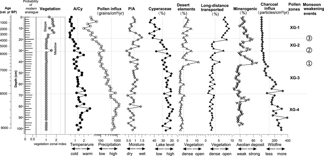
FIGURE 5. Vegetation types reconstructed by using discriminant functions of modern pollen spectra in the Tibetan Plateau, and interpretation of fossil pollen spectra from the Xuguo Co core in terms of vegetational, climatic, and environmental changes using Artemisia/Cyperaceae ratios, pollen influx, Poaceae/Artemisia ratios, Cyperaceae pollen percentage, pollen percentage of desert elements, long-distance-transported pollen percentage, minerogenic matter, and charcoal influx as proxies of summer temperature, monsoonal rainfall, moisture, lake level, vegetation coverage, aeolian activity, and wildfires, respectively. The average value of each proxy for the core is denoted by a dotted line.
Xuguo Co is located within the steppe region. Marsh meadow locally grows around the lake edge. The reconstructed vegetation shows that no typical alpine meadow existed over the past 9,200 years. Between 9,200 and 5,800 cal. yr BP, dense steppe dominated the pollen source area, implying that the MSE did not move westward to alter the vegetation in the pollen source area of this lake. However, significant changes in relative frequencies of dominant species such as Poaceae and Artemisia indicate the variations in plant abundance of different steppe components. High charcoal influx values indicate relatively frequent wildfires at 9,200–6,700 cal. yr BP. Approximately at 6,700 cal. yr BP, an abrupt increase in the relative frequencies of desert elements and long-distance-transported tree pollen, as well as a decrease in pollen influx, suggest a dramatic decline in pollen production, i.e., vegetation coverage, and then regional vegetation experienced another two significant drops in vegetation coverage at 5,800 and 4,100 cal. yr BP. After 4,100 cal. yr BP, marsh meadow and sparse steppe occupied the lake edge and other areas of the Xuguo Co catchment, respectively. The low charcoal influx values indicate fewer wildfires.
The biotic and abiotic proxies of vegetation, climate, and environment from Xuguo Co (Figure 5) reveal a Holocene history of climatic and environmental changes in its catchment. No Pediastrum colonies were found in the sediments from Xuguo Co, suggesting that the lake never became a fresh one during the last 9,200 years. The catchment of Xuguo Co witnessed four phases of climate change:
Phase I (9,200–8,000 cal. yr BP; pollen zone XC-4): The A/Cy ratio, a proxy of summer temperature, was at its maximum at 9,200–8,000 cal. yr BP, suggesting the highest summer temperature during the early Holocene. Total pollen influx, a proxy of monsoonal rainfall, reached its maximum too, implying the occurrence of the Holocene monsoonal rainfall maximum in the Xuguo Co catchment. The lake level also reached its highest, as suggested by the proxy of lake level (pollen percentages of Cyperaceae) following the monsoonal maximum. However, the G/A ratio, a proxy of moisture, was not at its highest level, being lower than its average over the past 9,200 years. Minerogenic matter, a proxy of eolian deposit, was at its average for the past 9,200 years, with a peak around 8,200 cal. yr BP. Meanwhile, dense vegetation, high summer temperature, and more thunderstorms in rainy seasons probably resulted in more wildfires in the catchment of Xuguo Co.
Phase II (8,000–5,800 cal. yr BP; pollen zone XC-3): Summer temperature and monsoonal rainfall decreased gradually, whereas moisture appeared to increase. The lake level still maintained a high level, although it was a little bit lower than that of phase I. Wildfires decreased in this phase. However, a significant monsoon-weakening event occurred around 6,700 cal. yr BP. This event is characterized by significant increases in the relative frequencies of desert pollen elements and long-distance-transported tree pollen (sparse vegetation), a decrease in pollen influx (less monsoonal rainfall and open vegetation), and more Cyperaceae (low lake level) and minerogenic matter (more or stronger winter and spring aeolian activities).
Phase III (5,800–3,600 cal. yr BP; pollen zone XC-2): After 5,800 cal. yr BP, summer temperature and monsoonal rainfall continued to decrease, and moisture experienced an obvious nonlinear increase. The lake level continued to decline, but it witnessed two major drops around 5,800 and 4,100 cal. yr BP, implying another two significant monsoon-weakening events. They are also characterized by rises of Cyperaceae pollen and peaks in desert pollen elements, long-distance-transported pollen, and minerogenic matter, indicating that they witnessed a low lake level, sparse vegetation, strong winter and spring aeolian activities, and few wildfires. As shown by Figure 5, modern climatic conditions in the catchment of Xuguo Co were established after the third monsoon-weakening event.
Phase IV (3,600 cal. yr BP to the present; pollen zone XC-1): Summer temperature and monsoonal rainfall reached their Holocene minima. Moisture experienced two peaks and one valley. Ther lake level dropped to reach its minimum with a reversal at 2,000 cal. yr BP, and marsh meadow grew along the lake edge. High values of desert elements, long-distance-transported tree pollen, and minerogenic matter indicate open vegetation and strong aeolian activities. Wildfires in this phase were still as few as those in phase III.
The fossil pollen record from Xuguo Co yielded Holocene climate variability in its catchment of the central TP (Figure 6). This record revealed summer temperature and monsoonal rainfall maxima at 9,200–8,000 cal. yr BP, followed by a nonlinearly decreasing trend from 8,000 to 3,600 cal. yr BP. Meanwhile, the ISM experienced three significant monsoon-weakening events at ca. 6,700, 5,800, and 4,100 cal. yr BP. Furthermore, modern climatic conditions with Holocene summer temperature and monsoonal rainfall minima were established after the third monsoon-weakening event around 4,100 cal. yr BP.
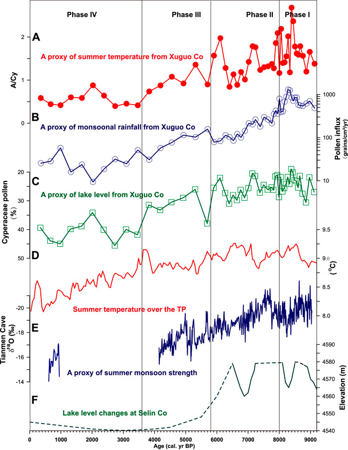
FIGURE 6. Comparison of proxies of summer temperature (A), monsoonal rainfall (B), and lake level (C) derived from the fossil pollen record of Xuguo Co with Holocene summer temperature change over the TP reconstructed by a synthesis of fossil pollen records [(D), Chen et al., 2020], stalagmite δ18O as a proxy of ISM strength from Tianmen Cave in Baingo [(E), Cai et al., 2012], and lake-level change at Selin Co [(F), Hou et al., 2021].
The pattern of summer temperature change in the catchment of Xuguo Co was also found in the same proxy (A/Cy ratio) of summer temperature in pollen records from Zigetang Co (Herzschuh et al., 2006), Nam Co (Li Q., 2017), and Selin Co (Sun et al., 1993) over the central TP. It also appears to resemble an integrated curve of summer temperature using published quantitative reconstructions in terms of fossil pollen records over the TP (Chen et al., 2020); their review showed that the summer temperature peak occurring in the early- to mid-Holocene coincided with the strengthening of summer solar insolation and the ISM, supporting our results. As suggested by pollen influx, a proxy of monsoonal rainfall, the Holocene monsoonal rainfall maximum occurred at 9,200–8,000 cal. yr BP, and monsoonal rainfall then showed a nonlinear decreasing trend, accompanying a similar change pattern for summer temperature. Our Holocene pattern of monsoonal rainfall is also supported by stalagmite δ18O, a proxy of ISM strength, from Tianmen Cave in Baingo near Xuguo Co (Figure 6). This δ18O record reveals that strong summer monsoons occurred in the early to middle Holocene (9,200–6,700 cal. yr BP), which was then followed by nonlinearly weakening summer monsoons (Cai et al., 2012). This pattern is also revealed by lake-level records from Xuguo and Selin Co in the central TP (Hou et al., 2021).
As shown by Figures 5, 6, monsoonal rainfall in the central TP, as well as the ISM strength, did not weaken gradually following the decline of seasonal insolation during the middle- to late-Holocene. They experienced three centennial-scale monsoon-weakening events to decrease from the early to middle Holocene maxima to the late Holocene minima. The first monsoon-weakening event occurred at 6,700 cal. yr BP, marking the end of the Holocene monsoon maximum. This event is also obvious in the δ18O records from Tianmen Cave (Cai et al., 2012) and Qunf Cave (Fleitmann et al., 2003), the lake-level record from Selin Co (Hou et al., 2021), and pollen records from Sumxi Co (Gasse et al., 1991), Selin Co (Sun et al., 1993), and Zigetang Co (Herzschuh et al., 2006). The second monsoon-weakening event occurred at 5,800 cal. yr BP, implying the beginning of the climatic deterioration over the central TP. This event was coincident with Bond event 4 (Bond et al., 1997), and it left its footprint in the δ18O records from Tianmen Cave and Qunf Cave, pollen records from Co Ngion (Shen et al., 2008a), and lake-level records from Ahung Co (Morrill et al., 2006) and Selin Co (Hou et al., 2021). The third monsoon-weakening event occurred at 4,100 cal. yr BP, marking the establishment of modern climatic conditions over the central TP. This event coincided with Bond event 3 and resulted in the Holocene minimum lake level at Ahung Co and Selin Co. It was also observed in pollen records from Co Ngion and Zigetang Co.
A paleoecological record derived from pollen and LOI analyses of sediments from Xuguo Co reveals vegetational, climatic, and environmental changes during the Holocene in its catchment over the central TP.
Our results show that steppe dominated the catchment of Xuguo Co during the Holocene. The MSE never moved westward to alter the vegetation in the pollen-source area of the lake. However, the pollen record exhibits significant changes in steppe components and vegetation coverage during the Holocene. During the early Holocene (9,200–8,000 cal. yr BP), dense steppe with the largest vegetation coverage occupied the catchment of Xuguo Co. Vegetation components showed significant changes and vegetation coverage decreased gradually after 8,000 cal. yr BP. From 4,100 to the present, marsh meadow has grown on the lake edge and sparse steppe has occupied the Xuguo Co catchment.
Our results also show the significant variability of summer temperature, monsoonal rainfall, lake level, aeolian activity, and wildfires during the Holocene in the central TP. Summer temperature, monsoonal rainfall, and lake-level maxima occurred at 9,200–8,000 cal. yr BP, when the Xuguo Co catchment witnessed few winter and spring aeolian activities and frequent wildfires. Temperature, rainfall, lake level, and wildfires then declined nonlinearly from 8,000 to 4,100 cal. yr BP. Modern climatic and environmental conditions were established after 4,100 cal. yr BP.
Additionally, our results reveal three monsoon-weakening events during the mid- to late-Holocene. These events occurred at ca. 6,700, 5,800, and 4,100 cal. yr BP. They were characterized by sparse vegetation, low lake level, and strong winter and spring aeolian activities.
The original contributions presented in the study are included in the article/Supplementary Material; further inquiries can be directed to the corresponding author.
CS, K-bL, and LT designed the study; CS and JP carried out the fieldwork; CS carried out lab work, identified pollen, and analyzed the pollen data; CS and K-bL wrote the manuscript.
This research was supported by grants from the National Natural Science Foundation of China (Grant Nos 42177437, 41372191, 42067061, 49371068, and 49871078), Special Project for Basic Research of Yunnan Province—Key Project (Grant No. 202101AS070006), the Yunnan Project for the Introduction of Advanced Talents (Grant No. 2013HA024), and the U.S. National Science Foundation (NSF grants ATM-9410491 and ATM-0081941).
The authors thank Xiangdong Yang for his help in the field trip, and Carrie Morrill for her help with radiocarbon dating.
The authors declare that the research was conducted in the absence of any commercial or financial relationships that could be construed as a potential conflict of interest.
All claims expressed in this article are solely those of the authors and do not necessarily represent those of their affiliated organizations, or those of the publisher, the editors, and the reviewers. Any product that may be evaluated in this article, or claim that may be made by its manufacturer, is not guaranteed or endorsed by the publisher.
Birks, H. J. B., and Gordon, A. D. (1985). Numerical methods in quaternary pollen analysis. London: Academic Press.
Bond, G., Showers, W., Cheseby, M., Lotti, R., Almasi, P., deMenocal, P., et al. (1997). A pervasive millennial-scale cycle in North Atlantic Holocene and Glacial climates. Science 278, 1257–1266.
Bonny, A. P. (1976). Recruitment of pollen to the seston and sediment of some English Lake District lakes. J. Ecol. 64, 859–887.
Brown, J. L., Hill, D. J., Dolan, A. M., Carnaval, A. C., and Haywood, A. M. (2018). PaleoClim, high spatial resolution paleoclimate surfaces for global land areas. Sci. Data 5, 180254. doi:10.1038/sdata.2018.254
Cai, Y., Zhang, H., Cheng, H., An, Z., Lawrence Edwards, R., Wang, X., et al. (2012). The Holocene Indian monsoon variability over the southern Tibetan Plateau and its teleconnections. Earth Planet. Sci. Lett. 335-336, 135–144. doi:10.1016/j.epsl.2012.04.035
Chen, F. H., Zhang, J. F., Liu, J. B., Cao, X. Y., Hou, J. Z., Zhou, L. P., et al. (2020). Climate change, vegetation history, and landscape responses on the Tibetan plateau during the Holocene: A comprehensive review. Quat. Sci. Rev. 243, 106444. doi:10.1016/j.quascirev.2020.106444
Clemens, S. C., Yamamoto, M., Thirumalai, K., Giosan, L., Richey, J. N., Nilsson-Kerr, K., et al. (2021). Remote and local drivers of Pleistocene south Asian summer monsoon precipitation: A test for future predictions. Sci. Adv. 7, eabg3848. doi:10.1126/sciadv.abg3848
Cui, A., Lu, H., Liu, X., Shen, C., Xu, D., Xu, B., et al. (2021). Tibetan plateau precipitation modulated by the periodically coupled westerlies and Asian monsoon. Geophys. Res. Lett. 48, e2020GL091543. doi:10.1029/2020GL091543
Dean, W. W. (1974). Determination of carbonate and organic matter in calcareous sediments and sedimentary rocks by loss on ignition: Comparison with other methods. J. Sediment. Petrol. 44, 242–248.
Fleitmann, D., Burns, S. J., Mudelsee, M., Neff, U., Kramers, J., Mangini, A., et al. (2003). Holocene forcing of the Indian monsoon recorded in a stalagmite from southern Oman. Science 300, 1737–1739.
Gasse, F., Arnold, M., Fontes, J. C., Fort, M., Gibert, E., Huc, A., et al. (1991). A 13,000-year climate record from Western Tibet. Nature 353, 742–745.
Herzschuh, U., Winter, K., Wunnemann, B., and Li, S. (2006). A general cooling trend on the central Tibetan Plateau throughout the Holocene recorded by the Lake Zigetang pollen spectra. Quat. Int. 154-155, 113–121.
Holland, M. M., Risser, P. G., and Naiman, R. J. (1991). Ecotones: The role of landscape boundaries in the management and restoration of changing environments. New York: Chapman & Hall.
Hou, Y., Long, H., Shen, J., and Gao, L. (2021). Holocene lake-level fluctuations of Selin Co on the central Tibetan Plateau: Regulated by monsoonal precipitation or meltwater? Quat. Sci. Rev. 261, 106919. doi:10.1016/j.quascirev.2021.106919
Hua, W., Lin, Z., Guo, D., Fan, G., Zhang, Y., Yang, K., et al. (2019). Simulated long-term vegetation—climate feedbacks in the Tibetan plateau. Asia-Pac. J. Atmos. Sci. 55, 41–52.
Immerzeel, W. W., van Beek, L. P. H., and Bierkens, M. F. P. (2010). Climate change will affect the Asian water towers. Science 328, 1382–1385.
Jacobson, G. L., and Bradshaw, R. H. W. (1981). The selection of sites for paleovegetational studies. Quat. Res. 16 (1), 80–96.
Kullman, L. (1990). Dynamics of altitudinal tree-limit in Sweden: A review. Nor. Geogr. Tidsskr. 44, 103–116.
Li, H. (2017).Climate change since the last deglaciation recorded by lake Zigetang, central Tibetan plateau. PhD dissertation. Yunnan Normal University.
Li, Q. (2017). Spatial variability and long-term change in pollen diversity in Nam Co catchment (central Tibetan Plateau): Implications for alpine vegetation restoration from a paleoecological perspective. Sci. Chin. Earth Sci. 61 (3), 270–284. doi:10.1007/s11430-017-9133-0
Liu, K-b., and Lam, S-N. N. (1985). Paleovegetational reconstruction based on modern and fossil pollen data: An application of discriminant analysis. Ann. Assoc. Am. Geogr. 75, 115–130.
Liu, K-b., Yao, Z., and Thompson, L. G. (1998). A pollen record of Holocene climatic changes from the Dunde ice cape, Tibetan Plateau. Geology 26, 135–138.
Liu, K-b. (1990). Holocene paleoecology of the boreal forest and great lakes-St. Lawrence forest in northern Ontario. Ecol. Monogr. 60, 179–212.
Lu, H., Wu, N., Liu, K.-b., Zhu, L., Yang, X., Yao, T., et al. (2011). Modern pollen distributions in Qinghai-Tibetan Plateau and the development of transfer functions for reconstructing Holocene environmental changes. Quat. Sci. Rev. 30, 947–966.
Maclean, I. M. D. (2019). Predicting future climate at high spatial and temporal resolution. Glob. Change Biol. 26 (1), 1003–1011. doi:10.1111/gcb.14876
Mancini, M. V. (2009). Holocene vegetation and climate changes from a peat pollen record of the forest – steppe ecotone, Southwest of Patagonia (Argentina). Quat. Sci. Rev. 28, 1490–1497.
Morrill, C., Overpeck, J. T., Cole, J. E., Liu, K.-b., Shen, C., and Tang, L. (2006). Holocene variations in the Asian monsoon inferred from the geochemistry of lake sediments in central Tibet. Quat. Res. 65, 232–243.
Mu, C., Abbott, B. W., Norris, A. J., Mu, M., Fan, C., Chen, X., et al. (2020). The status and stability of permafrost carbon on the Tibetan Plateau. Earth SciRev 211, 103433.
Nelson, D. M., Hu, F. S., Tian, J., Stefanova, I., and Brown, T. A. (2004). Response of C3 and C4 plants to middle-Holocene climatic variation near the prairie–forest ecotone of Minnesota. Proc. Natl. Acad. Sci. U. S. A. 101, 562–567.
Reasoner, M. A., and Jodry, M. A. (2000). Rapid response of alpine timberline vegetation to the Younger Dryas climate oscillation in the Colorado Rocky Mountains, USA. Geology 28, 51–54.
Reimer, P., Austin, W., Bard, E., Bayliss, A., Blackwell, P., Bronk Ramsey, C., et al. (2020). The IntCal20 northern hemisphere radiocarbon age calibration curve (0–55 cal kBP). Radiocarbon 62 (4), 725–757. doi:10.1017/RDC.2020.41
Shen, C., Liu, K-b., Morrill, C., Overpeck, J. T., Peng, J., and Tang, L. (2008a). Meadow-steppe ecotone shift and major central-scale droughts during the mid-Holocene in the central Tibetan Plateau. Ecology 89, 1079–1088.
Shen, C., Liu, K.-b., Tang, L., and Overpeck, J. T. (2021). Modern pollen rain in the Tibetan plateau. Front. Earth Sci. 9, 732441. doi:10.3389/feart.2021.732441
Shen, C., Liu, K.-b., Tang, L., and Overpeck, J. T. (2008b). Numerical analysis of modern and fossil pollen data from the Tibetan plateau. Ann. Assoc. Am. Geogr. 98 (4), 755–772. doi:10.1080/00045600802232342
Shen, C., Liu, K.-b., Tang, L., and Overpeck, J. T. (2006). Quantitative relationships between modern pollen rain and climate in the Tibetan Plateau. Rev. Palaeobot. Palyno. 140, 61–77.
Shen, C. (2003). Millennial-scale variations and centennial-scale events in the southwest Aian monsoon: Pollen evidence from Tibet, PhD dissertation. Louisiana State University.
Shen, M., Piao, S., Jeong, S., Zhou, L., Zeng, Z., Ciais, P., et al. (2015). Evaporative cooling over the Tibetan Plateau induced by vegetation growth. Proc. Natl. Acad. Sci. U. S. A. 112, 9299–9304.
Shumilovskikh, L. S., Novenko, E., and Giesecke, T. (2018). Long-term dynamics of the East European forest-steppe ecotone. J. Veg. Sci. 29, 416–426.
Stockmar, J. (1971). Tablets with spores used in absolute pollen analysis. Pollen Spores 13, 615–621.
Sun, X. J., Du, N. Q., Chen, Y. S., Gu, Z. Y., Liu, J. L., and Yuan, B. Y. (1993). Pollen analyses of lacustrine sediment in Seling Co, Tibet. Acta Bot. Sin. 35, 943–950.
Tang, L., Shen, C., Li, C., Peng, J., Liu, H., Liu, K-b., et al. (2009). Pollen-inferred vegetation and environmental changes in the central Tibetan Plateau since 8200 yr BP. Sci. China Ser. D-Earth Sci. 52, 1104–1114.
Tang, L., Shen, C., Lu, H., Li, C., and Ma, Q. (2021). Fifty years of quaternary palynology in the Tibetan plateau. Sci. Chin. Earth Sci. 64, 1825–1843. doi:10.1007/s11430-020-9809-5
Van Campo, E., and Gasse, F. (1993). Pollen- and diatom-inferred climatic and hydrological changes in changes in Sumxi Co basin (western Tibet) since 13,000 yr B.P. Quat. Res. 39, 300–313.
Wang, N., Liu, L., Zhang, Y., and Cao, X. (2022). A modern pollen data set for the forest–meadow–steppe ecotone from the Tibetan Plateau and its potential use in past vegetation reconstruction. Boreas. doi:10.1111/bor.12589
Wang, X., Yang, M., and Pang, G. (2014). Sensitivity of regional climate simulations to land-surface schemes on the Tibetan Plateau. Clim. Res. 62, 25–43.
Yao, T., Bolch, T., Chen, D., Gao, J., Immerzeel, W., Piao, S., et al. (2022). The imbalance of the Asian water tower. Nat. Rev. Earth Environ. doi:10.1038/s43017-022-00299-4
Yu, G., Tang, L., Yang, X., and Ke, X. (2001). Modern pollen samples from alpine vegetation on the Tibetan Plateau. Glob. Ecol. Biogeogr. 110, 503–519.
Keywords: fossil pollen, lake, steppe, monsoonal rainfall, Holocene, Tibetan Plateau
Citation: Shen C, Liu K-b, Tang L and Peng J (2023) Holocene vegetational and climatic history of the Xuguo Co catchment in the central Tibetan Plateau. Front. Earth Sci. 10:1025552. doi: 10.3389/feart.2022.1025552
Received: 23 August 2022; Accepted: 13 September 2022;
Published: 05 January 2023.
Edited by:
Xianyong Cao, Institute of Tibetan Plateau Research (CAS), ChinaReviewed by:
Feng Qin, Institute of Geographic Sciences and Natural Resources Research (CAS), ChinaCopyright © 2023 Shen, Liu, Tang and Peng. This is an open-access article distributed under the terms of the Creative Commons Attribution License (CC BY). The use, distribution or reproduction in other forums is permitted, provided the original author(s) and the copyright owner(s) are credited and that the original publication in this journal is cited, in accordance with accepted academic practice. No use, distribution or reproduction is permitted which does not comply with these terms.
*Correspondence: Caiming Shen, Y21zaGVuQGhvdG1haWwuY29t
Disclaimer: All claims expressed in this article are solely those of the authors and do not necessarily represent those of their affiliated organizations, or those of the publisher, the editors and the reviewers. Any product that may be evaluated in this article or claim that may be made by its manufacturer is not guaranteed or endorsed by the publisher.
Research integrity at Frontiers
Learn more about the work of our research integrity team to safeguard the quality of each article we publish.