- 1College of Marine Science, Hainan University, Haikou, China
- 2Laboratory for Marine Mineral Resources, Qingdao National Laboratory for Marine Science and Technology, Qingdao, China
- 3Qingdao Institute of Marine Geology, Ministry of Natural Resources, Qingdao, China
- 4College of Marine Geosciences Key Laboratory of Submarine Geosciences and Prospecting Technology, Ocean University of China, Qingdao, China
- 5State Key Laboratory of Loess and Quaternary Geology, Institute of Earth Environment, Chinese Academy of Sciences, Xi’an, China
- 6Marine Geological Institute of Hainan Province, Haikou, China
- 7School of Geoscience, China University of Petroleum, Qingdao, China
Hainan Island, the largest island in the northwestern South China Sea (SCS), is characterized by many tropical mountainous rivers that flow into the SCS. The geochemistry of these riverine sediments and the factors controlling the weathering intensity are still not well understood. In this study, sedimentary geochemistry has been investigated by using 45 riverine sediments collected from 18 major rivers on Hainan Island. The Hainan riverine sediments are only first-cycle rather than polycyclic sediments, and they faithfully reflect the present weathering intensity. The high and steady values of the Chemical Index of Alteration (CIA) indicate that the riverine sediments at different parts of the Hainan Island have overall undergone intensive chemical weathering. The low values of Weathering Index of Parker (WIP) and high
Highlights
The Hainan riverine sediments have undergone high weathering conditions.
The highest chemical weathering intensities of sediments in north Hainan are mainly influenced by the flat topography.
Weathering difference between southwest and east Hainan is caused by different summer rainfall conditions due to the orographic effect of the central mountains.
The weathering processes of the sediments in Hainan are typical transport-limited weathering regimes.
Introduction
Rivers are the main passages of land-derived sediments into the sea. The mineralogical and geochemical characteristics of sediments are controlled by lithology, topographic settings, weathering, diagenesis, sedimentary sorting, and recycling in catchments, and can be used to better understand the geochemical cycle, land–ocean interaction, and global change (Gaillardet et al., 1997; Yang et al., 2004; Liu et al., 2007; Li and Yang, 2010; Clift et al., 2014; Li G. et al., 2016; Jian et al., 2020; Xu et al., 2021).
Numerous studies have focused mainly on world-class rivers, such as the Amazon (Gaillardet et al., 1997; Bouchez et al., 2011), Mekong (Egashira et al., 1997), Congo (Dupré et al., 1996; Dinis et al., 2020), Yangtze and Yellow (Yang et al., 2004), and Pearl (Liu et al., 2007) rivers, because they play leading roles in delivering the great mass of water and terrestrial materials to the sea. However, subsequent studies have found that small rivers may have distinctive features in comparison to the major river systems in the world (Milliman and Syvitski, 1992; Milliman and Farnsworth, 2011; Yang and Yin, 2018). Thus, the significance of rivers with small drainage basins has been reconsidered. Recently, the characteristics of sediment geochemistry in small rivers, for example, central Japan (Ohta et al., 2005), western Korea (Xu et al., 2009), southeast China (Zhou et al., 2010; Su et al., 2017; Jian et al., 2020), Taiwan Island (Li et al., 2013; Deng et al., 2019), Malaysia, Sumatra, Borneo (Liu et al., 2012), Luzon, and Philippines (Liu et al., 2009), have aroused wide concern.
Hainan Island is the second largest island in China and the highest island in the northern South China Sea (SCS) and is located at the low latitude tropical area with heavy rainfall but low sediment load (∼4 Mt/yr, million tons per year, Zhang et al., 2013). Clay mineralogy analysis suggested that the weathering status of Hainan is comparable with that of the Pearl River and is inconsistent with that of rivers in Taiwan (Hu et al., 2014). To our knowledge, the geochemistry of the riverine sediments of Hainan Island and the weathering mechanism have not been constrained systemically, which are characterized by different lithological and topographic settings, and along with the tropical East Asian monsoon climate but with different rainfall. In this study, sediment geochemistry has been investigated on 45 riverine sediments collected from 18 major rivers on the Hainan Island. Our objectives are to 1) reveal the characteristic features of sediment geochemistry, 2) establish a geochemistry database for riverine sediments from Hainan Island, and 3) discuss the factors controlling the chemical weathering intensity of sediments in tropical Hainan.
Regional Setting
Hainan Island is the second largest island (35.4 × 10³ km2, Figure 1A) in China. The Hainan Island is tectonically stable (Metcalfe, 2009) and is characterized by central high mountains surrounding low hills, platforms, and plains in coastal regions (Figure 1B). The high mountains are located south of the central part of the island, accounting for 25.1% of the island’s area. The vast platforms are mainly distributed in the north Hainan (20–50 m above sea level), accounting for about one-third of the total area of the island (http://www.hnszw.org.cn/xiangqing.php?ID=54349, Figure 1B). The main rock types are granitic rocks which are mainly exposed in the southwest and east Hainan, and basalts are distributed predominantly in north Hainan. Sedimentary rocks, including slate, sandstone, limestone, and volcanic clastic, are scattered on the island, while Quaternary sediments have existed mainly in the coastal plain regions (Figure 2A, Shi et al., 2011).
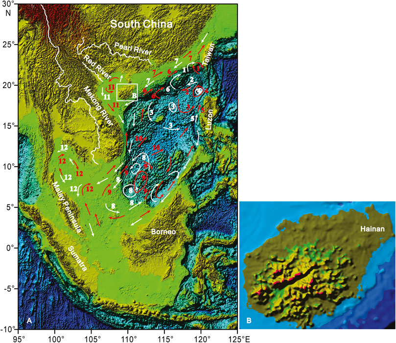
FIGURE 1. (A) Location map of the Hainan Island and the surface currents in the South China Sea. (B) Topographic map of the Hainan Island. Numbers for winter (white) and summer (red) surface currents: 1, loop current; 2, SCS branch of Kuroshio; 3, NW Luzon Cyclonic Gyre; 4, NW Luzon Cyclonic Eddy; 5, NW Luzon Coastal Current; 6, SCS Warm Current; 7, Guangdong Coastal Current; 8, SCS Southern Cyclonic Gyre; 9, SCS Southern Anticyclonic Gyre; 10, SE Vietnam Offshore Current; 11, Gulf of Tonkin Surface Current; 12, Gulf of Thailand Surface Current. Major surface currents after Liu et al. (2016).
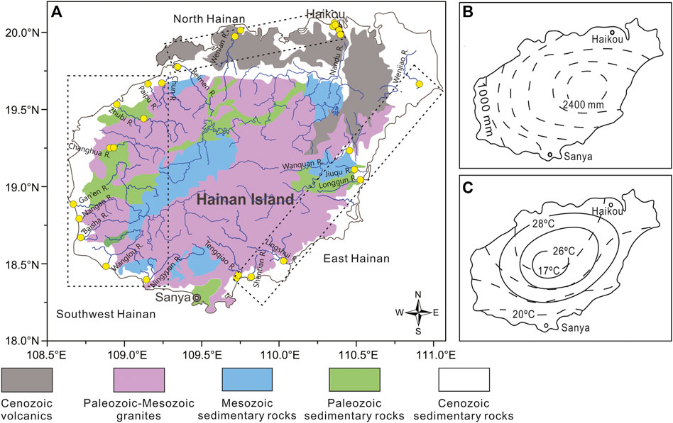
FIGURE 2. (A) Geological map and the locations of riverine samples on the Hainan Island. Modified from Shi et al. (2011) and Hu et al. (2014). (B) Annual rainfall and (C) temperature of January (dashed lines) and July (solid lines) of the Hainan Island (modified from http://gzdl.cooco.net.cn/testdetail/91943/). The blue lines indicate the river networks. Note that some of the sampling sites are overlapped on the map.
The Hainan Island is located on the northern edge of the tropics and is dominated by a tropical monsoon climate with dense vegetation cover (Committee of Vegetation Map of China, 2007; Zhang et al., 2013). The annual mean rainfall is ∼1,500 mm, with ∼80% of it occurring between May and October (http://www.worldweather.org), especially during the tropical cyclone period (Zhang et al., 2013). A large rainfall difference occurred between different parts of Hainan because of the orographic effect of the central mountains. The annual mean rainfall is distributed in a ring pattern, tending to reduce from more than 2,000 mm in the east and central Hainan to less than 1,000 mm in the southwest Hainan (Figure 2B). Fluvial drainage systems are well developed in the region. There are more than 100 rivers with a drainage area of over 100 km2 each. Over the past several decades, the total discharge and the total riverine sediment load from Hainan are ∼31 × 109 m3/yr and ∼4 Mt/yr (Zhang et al., 2013), respectively.
The annual mean temperature is 25.4°C, with a maximum between May and October (http://www.worldweather.org). In July, the isotherm showed concentric circles, increasing from the central mountain to the coastal areas. In January, temperatures were lower in north Hainan, increasing from the northern to the southern areas (Figure 2C). In general, there is a relatively wet and dry climate in east and southwest Hainan.
Materials and Methods
Sampling and Analytical Methods
A total of 45 riverine samples were collected downstream of estuary sites from 18 rivers on the Hainan Island in 2013 (Figure 2A). According to the lithology and climate conditions, the 18 studied rivers were grouped into three provinces: north Hainan (3 rivers), east Hainan (6 rivers), and southwest Hainan (9 rivers). These sediment samples were collected from surface channels or bed deposits. The fine-grained fraction (<63 μm, after eliminating sand) used for geochemical analysis was wet-sieved from the bulk samples to minimize the grain-size effect (Yang et al., 2002; Bouchez et al., 2011; Li et al., 2013; Guo et al., 2018), then oven-dried, and ground to a powder. The major and trace elements were analyzed using an X-ray fluorescence spectrometer (XRF, Axios PW4400) and Perkin Elmer ELAN DRC II ICP-MS, respectively. The analytical accuracy was determined by analyzing certified reference materials (BCR-2, BHVO-2, GBW07315, and GBW07316). The analytical precision, as verified by replicate analysis, was better than 5%. The clay mineral compositions of the sediments have been reported by Hu et al. (2014).
Calculation of Weathering Indexes
The Chemical Index of Alteration (CIA) and the Weathering Index of Parker (WIP) have been widely used as proxies for the chemical weathering intensity in drainage basins. The CIA value is used to quantify the chemical weathering degree experienced by sediments, referring to the progressive loss of mobile elements such as Na, Ca, and K (Nesbitt and Young, 1982). The higher CIA values indicate stronger weathering which could be interpreted as a measure of the conversion extent of feldspars to clays. In contrast, the WIP simply reflects concentrations of Mg, Ca, Na, and K, and thus, it is considerably affected by quartz dilution and used to evaluate weathering in quartz-rich sediments (Garzanti et al., 2013; Garzanti et al., 2014). Using molecular proportions, the CIA and WIP were calculated as follows:
where CaO* represents CaO associated with the silicate fraction only and is corrected for carbonate and phosphate (apatite). If the mole fraction of CaO ≤ Na2O, then the value of CaO was used. If CaO > Na2O, then the mole of CaO* was taken equivalent to Na2O (McLennan, 1993).
Weathering intensities can be calculated for each single element (Ca, Na, K, Sr, and Ba) mobilized during incongruent weathering of silicates by comparing its concentration to that of an immobile element in samples and the upper continental crust (UCC, i.e., α value, Gaillardet et al., 1999; Garzanti et al., 2013). We calculated the α value with reference to the concentration of an immobile element whose magmatic compatibility is close to that of the mobile element (Gaillardet et al., 1999):
The
Major and Trace Elements, and the Chemical Weathering Intensity
The element concentrations are shown in Table 1. Most of the Hainan riverine sediments have Sc/Th values smaller than 1, while two samples have values higher than 1 on the north Hainan (Figure 3A). The CIA values of all the samples range from 72 to 90 (mean of 81), which indicates moderate to intensive weathering occurred in the Hainan Island. The CIA values exhibit no obvious correlation with Sc/Th ratios (Figure 3A). The WIP values of all the samples range from 18 to 52 (mean of 34). The CIA and WIP values of all the samples display an inverse linear relationship (Figure 3B), showing a similar trend with the Taiwan rivers (Selvaraj and Chen, 2006), Pearl, Red, and Mekong (Liu et al., 2007), Malay Peninsula, Sumatra, Borneo (Liu et al., 2012), and Luzon rivers (Liu et al., 2009). As shown in Table 2, the similar values of the CIA at different parts of the Hainan Island suggest the similar weathering degree of Hainan riverine sediments. However, the lower mean WIP value of north Hainan suggests a higher weathering degree.
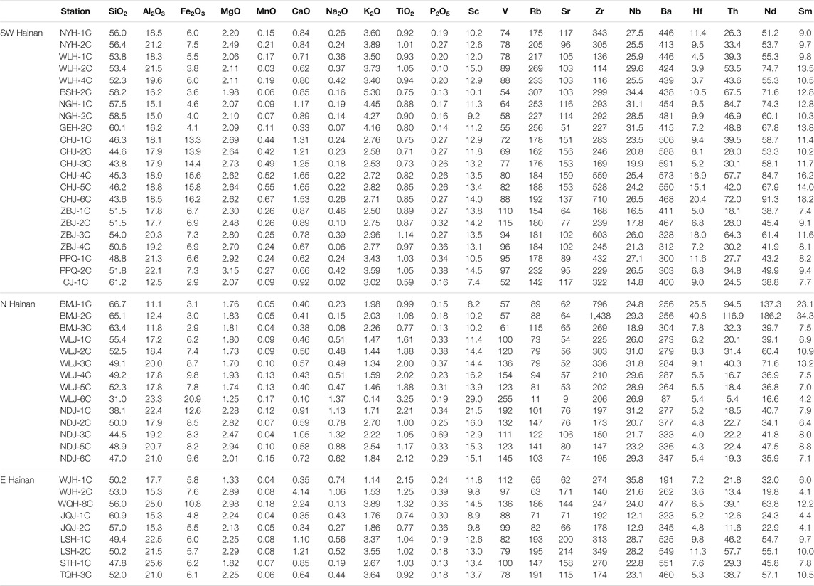
TABLE 1. Major (unit %) and trace element (unit mg kg−1) concentrations in the Hainan riverine sediments.
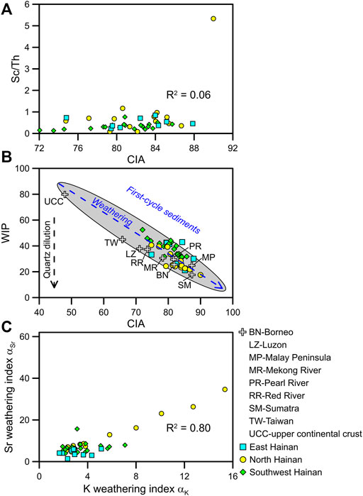
FIGURE 3. Relationships between (A) CIA and Sc/Th, (B) CIA and WIP, and (C)
The weathering indexes, such as
Discussion
Topographic Control on the Highest Weathering of North Hainan
The elements Sc and Th are largely water immobile during chemical weathering. Typically, felsic rocks generally have Sc/Th values smaller than 1, and mafic rocks have higher Sc/Th values (Taylor and McLennan, 1985). Most of the Hainan riverine sediments have Sc/Th values smaller than 1, indicating the dominance of the felsic rocks in the catchment (i.e., granitic rocks and Quaternary sediments). Only two samples have Sc/Th values higher than 1 on the north Hainan, indicating the influence of the mafic rocks in the catchment (i.e., basalt rocks). The CIA values exhibit no obvious correlation with Sc/Th ratios (Figure 3A), suggesting that the chemical weathering intensities are mostly independent of the lithology of their source areas. This is consistent with the previous studies on silicate weathering in river basins of mainland China (Li and Yang, 2010; Shao et al., 2012; Bi et al., 2015).
The comparison of CIA and WIP indexes could be used to identify the composition changes caused by weathering and recycling. The relationship between CIA and WIP is linear for first-cycle muds as well as for quartz-poor igneous materials (Garzanti et al., 2013; Garzanti et al., 2014; Guo et al., 2018). The inverse linear relationship of the CIA and WIP (Figure 3B) indeed suggests that the Hainan sediments only experienced a first sedimentary cycle, and thus faithfully reflects the present weathering intensity. Thus, the significantly low WIP values of sediments in north Hainan indicate strong chemical weathering intensity in the area.
Alkaline and alkaline earth metals tend to be depleted in riverine sediments due to their mobility during water–rock interactions (Stallard, 1988; Canfield, 1997; Garzanti et al., 2013). The
Lower Rainfall Control on Higher Weathering of Southwest Than East Hainan
The CIA and WIP values of sediments on the southwest and east Hainan Island are similar, indicating the similar weathering degree of the riverine sediments. However, the
Intensive Weathering of Hainan Compared With the Adjacent Area
The weathering trend can be further examined by ternary diagrams of Al2O3-CaO*+Na2O-K2O (A-CN-K) (Nesbitt and Young, 1984). Most of the samples of the Hainan Rivers are subparallel to the A–K axis (Figure 4). This reflects the strong removal of K-bearing minerals from the parent rocks, indicating the riverine sediments of the Hainan Island have undergone extensive weathering conditions. The chemical weathering intensity of Hainan Island is higher than that of UCC (Rudnick and Gao, 2003), Luzon (Liu et al., 2009), Taiwan rivers (Selvaraj and Chen, 2006), and Red and Mekong (Liu et al., 2007), and comparable with that of Pearl (Liu et al., 2007) and Borneo rivers (Liu et al., 2012), but less than that of Sumatra and Malay Peninsula rivers (Liu et al., 2012).
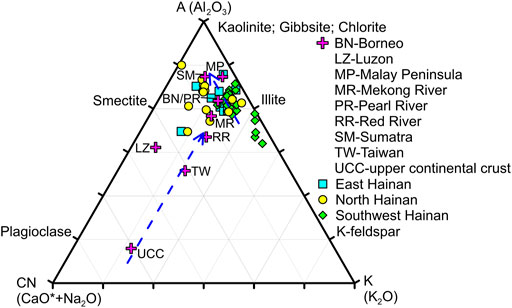
FIGURE 4. A–CN–K diagram showing the weathering trends of the Hainan riverine sediments. Average data of UCC (Rudnick and Gao, 2003), Luzon (Liu et al., 2009), Taiwan rivers (Selvaraj and Chen, 2006), Red, Mekong, and Pearl (Liu et al., 2007), Borneo (Liu et al., 2012), Sumatra and Malay Peninsula (Liu et al., 2012) rivers are plotted for comparison. Arrows indicate weathering trends exhibited by these sediments.
Clay minerals in riverine sediments originate mainly from the weathering products of parent rocks, and thus can also provide abundant information about weathering types and intensities. The kaolinite formation strongly depends on intensive hydrolysis under warm and humid climates. Illite and chlorite are mainly formed by weak hydrolysis and/or strong physical erosion of bedrock under relatively cold and dry climates (Chamley, 1989). Thus, the kaolinite/(illite + chlorite) ratios could be used to indicate the weathering types (physical erosion vs chemical weathering) of the sediments. The higher kaolinite/(illite + chlorite) values indicate stronger chemical weathering and weaker physical erosion, and vice versa (Colin et al., 2010; Wan et al., 2010; Alizai et al., 2012; Hu et al., 2014).
As shown in Figure 5, the CIA and kaolinite/(illite + chlorite) show good correlations of the different weathering degrees in the surrounding areas of the SCS. The weathering status of Hainan is comparable with that of the Pearl River in South China, Borneo, and weaker than those of the Malay Peninsula and Sumatra in tropical Southeast Asia. The Malay Peninsula and Sumatra are benefited from stable tectonic settings and tropical climate (Liu et al., 2012), favoring the intensity of chemical weathering with strong hydrolysis. However, the sediments of Taiwan in tropical/subtropical climate, highland part of the Mekong and Red River drainage basins in a subtropical climate, and even North Borneo in a tropical climate are characterized by strong physical erosion and moderate weathering conditions due to the combined effects of tectonic uplift and abundant monsoon rainfall (Liu et al., 2007; Liu et al., 2008; Liu et al., 2012; Sang et al., 2018). The correlations of CIA with kaolinite/(illite + chlorite) support our previous understandings based on the A–CN–K diagram analysis.
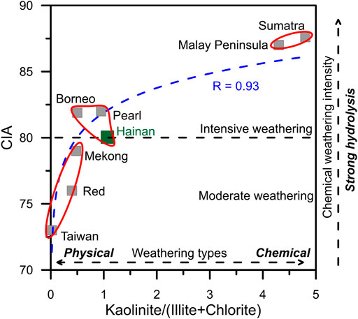
FIGURE 5. Correlation of CIA with kaolinite/(illite + chlorite) showing the different weathering degrees in the surrounding areas of the SCS. Data of the geochemical elements of Luzon rivers are from the study by Liu et al. (2009), Taiwan rivers from the study by Selvaraj and Chen (2006), the Red, Mekong, and Pearl rivers from the study by Liu et al. (2007), the Malay Peninsula, Sumatra, and Borneo rivers from the study by Liu et al. (2012), and Hainan rivers (this study). Data of the clay minerals of the Luzon rivers are from the study by Liu et al. (2009), the Taiwan rivers from the study by Liu et al. (2008), the Red, Mekong, and Pearl rivers from the study by Liu et al. (2007), the Malay Peninsula, Sumatra, and Borneo rivers from the study by Liu et al. (2012), and Hainan rivers from the study by Hu et al. (2014).
For the first and second largest islands in China, the sediment weathering intensities are different on Taiwan and Hainan Island. We can ascribe this to the tectonically active and stable conditions on the two islands (Selvaraj and Chen, 2006; Metcalfe, 2009). The silicate weathering processes of the small rivers in Taiwan Island are typical weathering-limited regimes because of the steep topographic relief and rapid erosion due to plate collision (Bi et al., 2015). The intensive chemical weathering of Hainan suggests that the weathering processes exceed the transportability to remove materials due to the dense vegetation cover (Committee of Vegetation Map of China, 2007) although the heavy rainfall and tropical cyclones can trigger short-term extreme flood events (Zhang et al., 2013). Soils and sediments exposed for long periods could be gradually leached and become strongly depleted in soluble cations (Stallard, 1988; Garzanti et al., 2013). Thus, the weathering processes of the sediments in the Hainan Island are typical transport-limited weathering regimes. This can also be supported by the ∼4 Mt/yr riverine sediment load from Hainan (Zhang et al., 2013), which shows a huge difference with Taiwan Island, that is, ∼384 Mt/yr (Dadson et al., 2003). Located in a tectonically stable area with high temperature and rainfall, the Hainan Island could afford sediments with intensive chemical weathering to the sea.
Conclusions
The concentrations of major and trace elements in the Hainan riverine sediments were analyzed. The high CIA, low WIP, and high weathering indexes (such as
Data Availability Statement
The original contributions presented in the study are included in the article/Supplementary Material, further inquiries can be directed to the corresponding author.
Author Contributions
BH contributed to conceptualization; JZ, RC, and XD performed formal analysis; FX, JZ, XL, GW, and JH contributed to original draft preparation; and BH and FX performed review and editing. All authors have read and agreed to the published version of the manuscript.
Funding
This study was jointly supported by the National Natural Science Foundation of China (41976192), the Project of the China Geological Survey (DD20191010), the Shandong Provincial Natural Science Foundation of China (ZR2020MD061 and ZR202103010094), the Open Foundation of the State Key Laboratory of Loess and Quaternary Geology (SKLLQG1707 and SKLLQG 1805), the National Key Research and Development Program of China (2018YFC0310001), and the Independent Project of Hainan Key Laboratory of Marine Geological Resources and Environment (2019256 (2020) HNHSKC-01 and ZZ (2020) 2019256-01).
Conflict of Interest
The authors declare that the research was conducted in the absence of any commercial or financial relationships that could be construed as a potential conflict of interest.
Publisher’s Note
All claims expressed in this article are solely those of the authors and do not necessarily represent those of their affiliated organizations, or those of the publisher, the editors, and the reviewers. Any product that may be evaluated in this article, or claim that may be made by its manufacturer, is not guaranteed or endorsed by the publisher.
Acknowledgments
We would like to thank the editor, and two reviewers for their constructive comments and reviews of the earlier versions of this study.
References
Alizai, A., Hillier, S., Clift, P. D., Giosan, L., Hurst, A., VanLaningham, S., et al. (2012). Clay mineral Variations in Holocene Terrestrial Sediments from the Indus Basin. Quaternary Res. 77, 368–381. doi:10.1016/j.yqres.2012.01.008
Bi, L., Yang, S., Li, C., Guo, Y., Wang, Q., Liu, J. T., et al. (2015). Geochemistry of River-Borne Clays Entering the East China Sea Indicates Two Contrasting Types of Weathering and Sediment Transport Processes. Geochem. Geophys. Geosyst. 16, 3034–3052. doi:10.1002/2015GC005867
Bouchez, J., Gaillardet, J., France-Lanord, C., Maurice, L., and Dutra-Maia, P. (2011). Grain Size Control of River Suspended Sediment Geochemistry: Clues from Amazon River Depth Profiles. Geochem. Geophys. Geosyst. 12, a–n. doi:10.1029/2010GC003380
Canfield, D. E. (1997). The Geochemistry of River Particulates from the continental USA: Major Elements. Geochim. Cosmochim. Ac. 61, 3349–3365. doi:10.1016/s0016-7037(97)00172-5
Clift, P. D., Wan, S., and Blusztajn, J. (2014). Reconstructing Chemical Weathering, Physical Erosion and Monsoon Intensity since 25Ma in the Northern South China Sea: A Review of Competing Proxies. Earth-Sci. Rev. 130, 86–102. doi:10.1016/j.earscirev.2014.01.002
Colin, C., Siani, G., Sicre, M.-A., and Liu, Z. (2010). Impact of the East Asian Monsoon Rainfall Changes on the Erosion of the Mekong River basin over the Past 25,000yr. Mar. Geol. 271, 84–92. doi:10.1016/j.margeo.2010.01.013
Committee of Vegetation Map of China (2007). Vegetation Map of the People's Republic of China. Beijing: Geological Publishing House.
Dadson, S. J., Hovius, N., Chen, H., Dade, W. B., Hsieh, M.-L., Willett, S. D., et al. (2003). Links between Erosion, Runoff Variability and Seismicity in the Taiwan Orogen. Nature 426, 648–651. doi:10.1038/nature02150
Deng, K., Yang, S., Bi, L., Chang, Y.-P., Su, N., Frings, P., et al. (2019). Small Dynamic Mountainous Rivers in Taiwan Exhibit Large Sedimentary Geochemical and Provenance Heterogeneity over Multi-Spatial Scales. Earth Planet. Sci. Lett. 505, 96–109. doi:10.1016/j.epsl.2018.10.012
DePaolo, D. J., Maher, K., Christensen, J. N., and McManus, J. (2006). Sediment Transport Time Measured with U-Series Isotopes: Results from ODP North Atlantic Drift Site 984. Earth Planet. Sci. Lett. 248, 394–410. doi:10.1016/j.epsl.2006.06.004
Dinis, P. A., Garzanti, E., Hahn, A., Vermeesch, P., and Cabral-Pinto, M. (2020). Weathering Indices as Climate Proxies. A Step Forward Based on Congo and SW African River Muds. Earth-Sci. Rev. 201, 103039. doi:10.1016/j.earscirev.2019.103039
Dupré, B., Gaillardet, J., Rousseau, D., and Allègre, C. J. (1996). Major and Trace Elements of River-Borne Material: The Congo Basin. Geochim. Cosmochim. Ac. 60, 1301–1321. doi:10.1016/0016-7037(96)00043-9
Egashira, K., Fujii, K., Yamasaki, S., and Virakornphanich, P. (1997). Rare Earth Element and clay Minerals of Paddy Soils from the central Region of the Mekong River, Laos. Geoderma 78, 237–249. doi:10.1016/S0016-7061(97)00031-1
Gaillardet, J., Dupré, B., and Allègre, C. J. (1999). Geochemistry of Large River Suspended Sediments: Silicate Weathering or Recycling Tracer. Geochim. Cosmochim. Ac. 63, 4037–4051. doi:10.1016/S0016-7037(99)00307-5
Gaillardet, J., Dupre, B., Allegre, C. J., and Négrel, P. (1997). Chemical and Physical Denudation in the Amazon River Basin. Chem. Geol. 142, 141–173. doi:10.1016/S0009-2541(97)00074-0
Garzanti, E., Padoan, M., Setti, M., Najman, Y., Peruta, L., and Villa, I. M. (2013). Weathering Geochemistry and Sr-Nd Fingerprints of Equatorial Upper Nile and Congo Muds. Geochem. Geophys. Geosyst. 14, 292–316. doi:10.1002/ggge.20060
Garzanti, E., Vermeesch, P., Padoan, M., Resentini, A., Vezzoli, G., and Andò, S. (2014). Provenance of Passive-Margin Sand (Southern Africa). J. Geol. 122, 17–42. doi:10.1086/674803
Guo, Y., Yang, S., Su, N., Li, C., Yin, P., and Wang, Z. (2018). Revisiting the Effects of Hydrodynamic Sorting and Sedimentary Recycling on Chemical Weathering Indices. Geochim. Cosmochim. Ac. 227, 48–63. doi:10.1016/j.gca.2018.02.015
Hu, B., Li, J., Cui, R., Wei, H., Zhao, J., Li, G., et al. (2014). Clay Mineralogy of the Riverine Sediments of Hainan Island, South China Sea: Implications for Weathering and Provenance. J. Asian Earth Sci. 96, 84–92. doi:10.1016/j.jseaes.2014.08.036
Jian, X., Yang, S., Hong, D., Liang, H., Zhang, S., Fu, H., et al. (2020). Seasonal Geochemical Heterogeneity of Sediments from a Subtropical Mountainous River in SE China. Mar. Geol. 422, 106120. doi:10.1016/j.margeo.2020.106120
Li, C.-S., Shi, X.-F., Kao, S.-J., Liu, Y.-G., Lyu, H.-H., Zou, J.-J., et al. (2013). Rare Earth Elements in fine-grained Sediments of Major Rivers from the High-Standing Island of Taiwan. J. Asian Earth Sci. 69, 39–47. doi:10.1016/j.jseaes.2013.03.001
Li, C., and Yang, S. (2010). Is Chemical index of Alteration (CIA) a Reliable Proxy for Chemical Weathering in Global Drainage Basins. Am. J. Sci. 310, 111–127. doi:10.2475/02.2010.03
Li, C., Yang, S., Lian, E., Bi, L., and Zhang, Z. (2015). A Review of Comminution Age Method and its Potential Application in the East China Sea to Constrain the Time Scale of Sediment Source-To-Sink Process. J. Ocean Univ. China 14, 399–406. doi:10.1007/s11802-015-2769-8
Li, C., Yang, S., Zhao, J.-x., Dosseto, A., Bi, L., and Clark, T. R. (2016a). The Time Scale of River Sediment Source-To-Sink Processes in East Asia. Chem. Geol. 446, 138–146. doi:10.1016/j.chemgeo.2016.06.012
Li, G., Yan, W., and Zhong, L. (2016b). Element Geochemistry of Offshore Sediments in the Northwestern South China Sea and the Dispersal of Pearl River Sediments. Prog. Oceanogr. 141, 17–29. doi:10.1016/j.pocean.2015.11.005
Liu, Z., Colin, C., Huang, W., Le, K. P., Tong, S., Chen, Z., et al. (2007). Climatic and Tectonic Controls on Weathering in south China and Indochina Peninsula: Clay Mineralogical and Geochemical Investigations from the Pearl, Red, and Mekong Drainage Basins. Geochem. Geophys. Geosyst. 8, a–n. doi:10.1029/2006GC001490
Liu, Z., Tuo, S., Colin, C., Liu, J. T., Huang, C.-Y., Selvaraj, K., et al. (2008). Detrital fine-grained Sediment Contribution from Taiwan to the Northern South China Sea and its Relation to Regional Ocean Circulation. Mar. Geol. 255, 149–155. doi:10.1016/j.margeo.2008.08.003
Liu, Z., Wang, H., Hantoro, W. S., Sathiamurthy, E., Colin, C., Zhao, Y., et al. (2012). Climatic and Tectonic Controls on Chemical Weathering in Tropical Southeast Asia (Malay Peninsula, Borneo, and Sumatra). Chem. Geol. 291, 1–12. doi:10.1016/j.chemgeo.2011.11.015
Liu, Z., Zhao, Y., Colin, C., Siringan, F. P., and Wu, Q. (2009). Chemical Weathering in Luzon, Philippines from clay Mineralogy and Major-Element Geochemistry of River Sediments. Appl. Geochem. 24, 2195–2205. doi:10.1016/j.apgeochem.2009.09.025
Liu, Z., Zhao, Y., Colin, C., Stattegger, K., Wiesner, M. G., Huh, C.-A., et al. (2016). Source-to-sink Transport Processes of Fluvial Sediments in the South China Sea. Earth-Sci. Rev. 153, 238–273. doi:10.1016/j.earscirev.2015.08.005
Metcalfe, I. (2009). Late Palaeozoic and Mesozoic Tectonic and Palaeogeographical Evolution of SE Asia. Geol. Soc. London. Spec. Publ. 315, 7–23. doi:10.1144/SP315.2
Milliman, J. D., and Farnsworth, K. L. (2011). River Discharge to the Coastal Ocean – A Global Synthesis. New York: Cambridge University Press.
Milliman, J. D., and Syvitski, J. P. M. (1992). Geomorphic/tectonic Control of Sediment Discharge to the Ocean: the Importance of Small Mountainous Rivers. J. Geol. 100, 525–544. doi:10.1086/629606
Nesbitt, H. W., and Young, G. M. (1982). Early Proterozoic Climates and Plate Motions Inferred from Major Element Chemistry of Lutites. Nature 299, 715–717. doi:10.1038/299715a0
Nesbitt, H. W., and Young, G. M. (1984). Prediction of Some Weathering Trends of Plutonic and Volcanic Rocks Based on Thermodynamic and Kinetic Considerations. Geochim. Cosmochim. Ac. 48, 1523–1534. doi:10.1016/0016-7037(84)90408-3
Ohta, A., Imai, N., Terashima, S., and Tachibana, Y. (2005). Application of Multi-Element Statistical Analysis for Regional Geochemical Mapping in Central Japan. Appl. Geochem. 20, 1017–1037. doi:10.1016/j.apgeochem.2004.12.005
Rudnick, R. L., and Gao, S. (2003). “Composition of the continental Crust,” in Treatise on Geochemistry. Editors D. H. Heinrich, and K. T. Karl (Oxford (Pergamon), 1–64. doi:10.1016/b0-08-043751-6/03016-4
Sang, P. N., Liu, Z., Zhao, Y., Zhao, X., Pha, P. D., and Long, H. V. (2018). Chemical Weathering in central Vietnam from clay Mineralogy and Major-Element Geochemistry of Sedimentary Rocks and River Sediments. Heliyon 4, e00710. doi:10.1016/j.heliyon.2018.e00710
Selvaraj, K., and Chen, C. T. A. (2006). Moderate Chemical Weathering of Subtropical Taiwan: Constraints from Solid‐Phase Geochemistry of Sediments and Sedimentary Rocks. J. Geol. 114, 101–116. doi:10.1086/498102
Shao, J., Yang, S., and Li, C. (2012). Chemical Indices (CIA and WIP) as Proxies for Integrated Chemical Weathering in China: Inferences from Analysis of Fluvial Sediments. Sediment. Geol. 265-266, 110–120. doi:10.1016/j.sedgeo.2012.03.020
Shi, X., Kohn, B., Spencer, S., Guo, X., Li, Y., Yang, X., et al. (2011). Cenozoic Denudation History of Southern Hainan Island, South China Sea: Constraints from Low Temperature Thermochronology. Tectonophysics 504, 100–115. doi:10.1016/j.tecto.2011.03.007
Stallard, R. F. (1988). “Weathering and Erosion in the Humid Tropics,” in Physical and Chemical Weathering in Geochemical Cycles. Editors A. Lerman, and M. Meybeck (Dordrecht, Kluwer), 225–246. doi:10.1007/978-94-009-3071-1_11
Su, N., Yang, S., Guo, Y., Yue, W., Wang, X., Yin, P., et al. (2017). Revisit of Rare Earth Element Fractionation during Chemical Weathering and River Sediment Transport. Geochem. Geophys. Geosyst. 18, 935–955. doi:10.1002/2016GC006659
Suresh, P. O., Dosseto, A., Hesse, P. P., and Handley, H. K. (2013). Soil Formation Rates Determined from Uranium-Series Isotope Disequilibria in Soil Profiles from the southeastern Australian highlands. Earth Planet. Sci. Lett. 379, 26–37. doi:10.1016/j.epsl.2013.08.004
Taylor, S. R., and McLennan, S. M. (1985). The Continental Crust: Its Composition and Evolution. Oxford: Blackwell Scientific Publications.
Wan, S., Li, A., Clift, P. D., Wu, S., Xu, K., and Li, T. (2010). Increased Contribution of Terrigenous Supply from Taiwan to the Northern South China Sea since 3Ma. Mar. Geol. 278, 115–121. doi:10.1016/j.margeo.2010.09.008
Xu, F., Hu, B., Zhao, J., Liu, X., Xu, K., Xiong, Z., et al. (2021). Provenance and Weathering of Sediments in the Deep basin of the Northern South China Sea during the Last 38 Kyr. Mar. Geol. 440, 106602. doi:10.1016/j.margeo.2021.106602
Xu, Z., Lim, D., Choi, J., Yang, S., and Jung, H. (2009). Rare Earth Elements in Bottom Sediments of Major Rivers Around the Yellow Sea: Implications for Sediment Provenance. Geo-Mar. Lett. 29, 291–300. doi:10.1007/s00367-009-0142-x
Yang, S., Jung, H.-S., and Li, C. (2004). Two Unique Weathering Regimes in the Changjiang and Huanghe Drainage Basins: Geochemical Evidence from River Sediments. Sediment. Geol. 164, 19–34. doi:10.1016/j.sedgeo.2003.08.001
Yang, S., and Yin, P. (2018). Sediment Source-To-Sink Processes of Small Mountainous Rivers under the Impacts of Natural Environmental Changes and Human Activities. Mar. Geol. Quat. Geol. 38, 1–10. (in Chinese with English abstract).
Yang, S. Y., Jung, H. S., Choi, M. S., and Li, C. X. (2002). The Rare Earth Element Compositions of the Changjiang (Yangtze) and Huanghe (Yellow) River Sediments. Earth Planet. Sci. Lett. 201, 407–419. doi:10.1016/S0012-821X(02)00715-X
Yang, Z. H., Jia, J. J., Wang, X. K., and Gao, J. H. (2013). Characteristics and Variations of Water and Sediment Fluxes into the Sea of the Top three rivers of Hainan in Recent 50 Years. Mar. Sci. Bull. 32, 92–99. (in Chinese with English abstract).
Zhang, J., Wang, D. R., Jennerjahn, T., and Dsikowitzky, L. (2013). Land-sea Interactions at the East Coast of Hainan Island, South China Sea: A Synthesis. Cont. Shelf Res. 57, 132–142. doi:10.1016/j.csr.2013.01.004
Keywords: geochemistry, riverine sediment, weathering, Hainan Island, South China Sea
Citation: Xu F, Hu B, Zhao J, Liu X, Cui R, Ding X, Wang G and Huang J (2022) Topographic and Climatic Control on Chemical Weathering of Mountainous Riverine Sediments of Hainan Island, South China Sea. Front. Earth Sci. 9:770236. doi: 10.3389/feart.2021.770236
Received: 03 September 2021; Accepted: 28 December 2021;
Published: 21 January 2022.
Edited by:
Jiangong Wei, Guangzhou Marine Geological Survey, ChinaCopyright © 2022 Xu, Hu, Zhao, Liu, Cui, Ding, Wang and Huang. This is an open-access article distributed under the terms of the Creative Commons Attribution License (CC BY). The use, distribution or reproduction in other forums is permitted, provided the original author(s) and the copyright owner(s) are credited and that the original publication in this journal is cited, in accordance with accepted academic practice. No use, distribution or reproduction is permitted which does not comply with these terms.
*Correspondence: Bangqi Hu, YmFuZ3FpaHVAZ21haWwuY29t
 Fangjian Xu
 Bangqi Hu2,3*
 Xiting Liu