
95% of researchers rate our articles as excellent or good
Learn more about the work of our research integrity team to safeguard the quality of each article we publish.
Find out more
ORIGINAL RESEARCH article
Front. Earth Sci. , 25 March 2021
Sec. Quaternary Science, Geomorphology and Paleoenvironment
Volume 9 - 2021 | https://doi.org/10.3389/feart.2021.656193
This article is part of the Research Topic Human-Environmental Interactions in Prehistoric Periods View all 16 articles
 Panpan Chen1,2
 Peng Lu2*Shugang Yang3*
 Michael Storozum4Ruixia Yang5Yan Tian2Hui Wang6Qian Wu7Junjie Xu8Xia Wang2Lijie Yan2Haiguo Zhai2
Buried underneath modern Zhengzhou city in Henan Province, China, lies the archeological remains of one of the ancient capital cities of the Shang dynasty (1766 – 1122 BCE). Although it is likely that people planned this Shang capital city according to the demands of the surrounding environment, there is no clear relationship between the current environment, such as the hydrology and topography, and the ancient city’s layout. To better understand the relationship between planning principles used during the Shang dynasty and the nearby environment at Zhengzhou, we measured and sampled stratigraphic exposures at excavation locations throughout Zhengzhou. Through these excavations we obtained both absolute and relative chronological data from each culture layer, enabling us to use geospatial interpolation and analysis methods to reconstruct the ancient landscape. The results show that ancient city’s different activity areas had a close relationship with their environmental context. For example, the Shang dynasty palace was located on high ground and workshops were located down below along the courses of ancient rivers. In conclusion, we argue that research that merges geomorphology and archeology is a necessary prerequisite for understanding the development of urban areas.
Cities are the most complex form of human settlement and are usually a signal of increasing socio-political complexity. During the early Neolithic, societies shifted from a highly mobile, hunting and gathering, subsistence strategy to a lifeway more grounded in permanent settlement and agriculture. Based on evidence from archeological excavations, archeologists have uncovered a significant amount of evidence that the earliest settlements were not only small in size but also had limited functions and activity spaces (Trigger, 1989; Renfrew and Bahn, 1991; Liu, 2004; Lu et al., 2013). As population increased and settlements became more numerous, some of these settlements became “central places” as they developed into political, economic, and regional centers. Therefore, location and form of early cities is likely an outcome of a long term, regional, process of increasing socio-political complexity. The original layout of a city not only reflects the characteristics of the natural environment but also the cultural beliefs (Wheatley, 1971). The geographic position and spatial arrangement of early cities is a significant factor for understanding human-environment interactions.
A significant amount of research has examined the interconnection between the layout of early cities and their relationship to landscape evolution. For example, Assefa Getaneh et al. (2018) reconstructed the spatial distribution of some pre-Aksumite cultural structures like stone-based walls using magnetic reconnaissance survey in the Seglamen Site of northern Ethiopia. Schwerin et al. (2016) drew a more accurate archeological map in the Copan site of Honduras using LiDAR data. Gianna Ayala et al. (2017) reconstructed the alluvial landscape of Neolithic Çatalhoyük, central southern Turkey. Sun et al. (2017) reported the settlement structure of Neolithic Shimao which was believed as a regional political and ritual center on China’s north Loess Plateau. Wu et al. (2019) and Storozum et al. (2020)’s work examines the “city on top of a city’ phenomenon at Kaifeng from a geoarcheological perspective. Qian (2019) reconstructed the spatial pattern of North Wei (386-534 AD) Capital Luoyang City. Although this research has helped identify characteristics of the internal layout of several ancient cities, there is generally less discussion concerning human-environmental interaction from the perspective of landscape evolution. As a result, this research loses useful information concerning the development of early cities and the process of urbanization. Moreover, it is also difficult to identify the roles that the nearby environment plays in supporting a developing cityscape.
From 2011 to 2020, we conducted a multidisciplinary archeological research project at the early Shang dynasty capital of Zhengzhou, one of the oldest cities in the China in an attempt to recover the plan of the city’s original layout and examine this layout’s relationship to the contemporaneous geomorphological units. In general, our research at Zhengzhou attempts to use a geoarcheological investigation to answer several important questions:
• Why did the ancient Shang people build their capital there?
• How was its relationship with the regional terrain?
• What were the early landscape features like?
• How did the ancient landscape influence the city’s layout?
Zhengzhou Shang City is an important early capital city of China. The capital belonged to the early stage of Shang dynasty (ca. 1,600 BC) (Ren and Liu, 2019). This archeological site is located directly underneath the modern Zhengzhou city in central Henan Province and covers over 25 km2 (Chen, 1999). Here, archeologists have found remains of the ancient city, including massive city walls, a palace, and large bronze ritual vessels (Chen and Zeng, 1991; HICRA, 1993, 2001; HICRA and ZICRA, 1999; Yuan et al., 2004).
The area of the Shang dynasty city of Zhengzhou was located at the transitional zone between the Loess Plateau and the North China Plain. This makes the region high in the west and low in the east. Although the Yellow River is no more than 20 km to the north of the city, the city is actually located within the catchment of the Huai River (Figure 1). On the northern and southern edges of the Shang dynasty city is a small river called the Jinshui River. To the south of the Shang city is the Xiong’er River. Both rivers are tertiary tributaries of the Huai River. This region is located within a warm temperate continental monsoonal climate. The annual average temperature is 14°C and the annual precipitation is 600 mm (Shi, 1983).
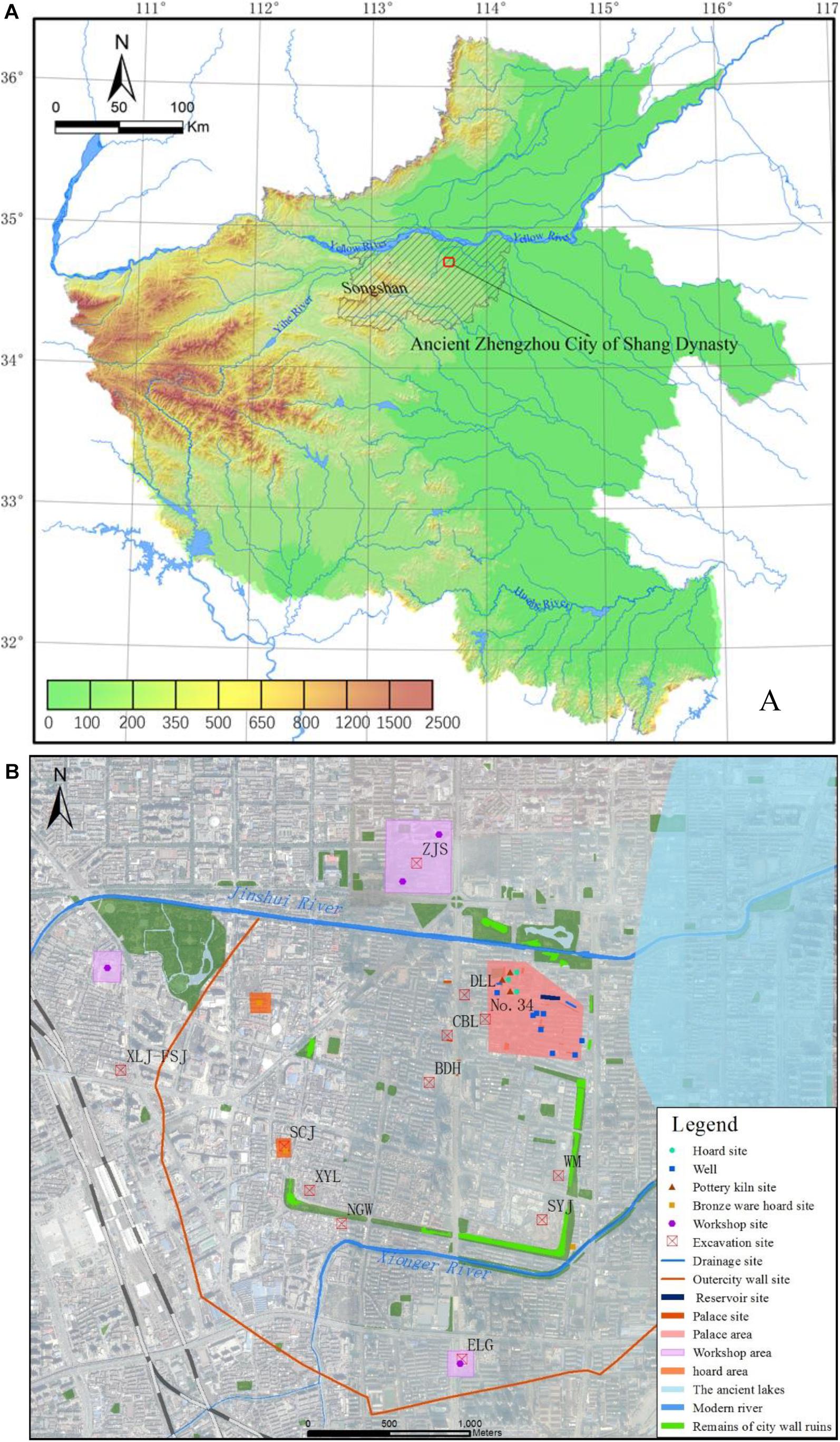
Figure 1. Research area. (A) The location of Zhengzhou Shang city in Henan Province; (B) The layout of Zhengzhou Shang city. The excavation sites in Figure 3 are labeled on this map.
Over the past 60 years, archeologists have conducted a wide range of excavations in Zhengzhou Shang City (An, 1954; Zhao et al., 1957). In general, archeologists now understand the layout of the ancient city (Yuan and Zeng, 2004; Liu et al., 2010; Yuan, 2018). Archeologists have divided the city into three areas, the outer city, the inner city, and the palace city (Figure 1). Each of these areas is divided by walls. The walls of outer city were round and archeologists have only found the remains of these walls in the western and southern parts of the city (Yuan and Zeng, 2004; Jiang et al., 2009; Liu et al., 2010; Yuan, 2018). The walls of the inner city are approximately rectangular and there was a beveled edge at the northeast corner. The palace city was located at the northeastern part of the inner city. Several Shang dynasty palaces have been found there (An and Yang, 1983; Zeng et al., 2000). Other activity areas, like workshops, hoards, and sacrificial zones, are scattered throughout the site (Pan, 2010; Chang, 2018; Hou, 2018; Zhang, 2018). The northern and southern sides of the outer city are flanked by rivers, the Jinshui River in the north and the Xionger River in the south. The Jinshui River’s course still runs through the modern area where the inner city was located. To the east of the city was a large lake (Huang, 2011; Huang and Wang, 2014), but so far, no geological evidence demonstrate the lakes existence has been documented.
We conducted a detailed field survey around the Shang city and the surrounding areas. Before the survey, we drew a detailed geomorphic map of the region using the DEM, remote sensing images, as well as geological and topographic maps. We observed, measured, and analyzed exposed sections in different geomorphic settings around Zhengzhou. The color, depth, structure, sediment type, and the presence of absence of inclusions in every layer were recorded in detail. The stratigraphic profiles were drawn according to a fixed and standardized scale. From these field observations, we interpreted the approximate time of deposition and depositional environment.
Some of the most important sections and layers were sampled. Sediment samples were collected at equal intervals of 5 cm. There are two ways to collect samples for dating purposes. The 14C samples were collected from the carbon-rich strata. If the stratum did not contain much carbonized flecks, we collected OSL samples to date the layers. In total, we collected 583 sediment samples, 1 14C samples and 12 OSL samples.
Radiocarbon dating was done at Peking University. Radiocarbon samples were tested by the methods of Accelerator Mass Spectrometer (AMS). The half-life period of 14C is 5,568 years. BP is the radiocarbon years before present (Present = AD 1950). Tree rings enable the calibration of radiocarbon curves, known as IntCal13 (Reimer et al., 2013). We used OxCal to calibrate the radiocarbon dates.
The OSL samples were analyzed at the Institute of Geography, Henan Academy of Sciences, China. Samples pretreatment was carried out using fine particle methods. Calcium, carbonate and organic matter were removed from all samples using HCl and H2O2. The quartz particles in the 4-11 μm fraction were tested in the machine. Every sample was tested 8-12 sample slices. The method for measure is the Single Aliquot Regenerative-dose (SAR) protocol. The contents of U, TH, and K in the samples were determined by neutron activation method (NAA). We measured the measured moisture content and the absolute error was set at 5%. The aliquots num is the number of practical test pieces in the final calculation (Lai and Ou, 2013).
Particle size analysis was also carried out at the Institute of Geography, Henan Academy of Sciences. Organic matter and inorganic carbon were removed from the samples using diluted hydrochloric acid and hydrogen peroxide. Then 10 mL of 0.05 mol/L sodium hexametaphosphate was added to the sample. After the particles were well dispersed by heating the sample to a boil, each sample was analyzed using a laser particle size analyzer. The measuring range of particle diameter is 0.02-2000 μm.
Since 1984, there have been around 200 excavations at the Shang city underneath modern Zhengzhou. We collected all the stratigraphic information from each excavation report and used these data to build a GIS database. The data include geographic position, coordinates, altitude, depositional types, sediment characteristics and stratigraphic thickness. Using these data, we can precisely display the stratigraphic information on a map to conduct spatial analyses.
We used the Natural Neighbor method to simulation the landscape evolution for the area. First, this method creates a Voronoi polygon using the existing spatial data. The points waiting to be solved are also used to create a Voronoi polygon. The intersection of both polygons forms a pattern, from which, according to the area of each spot, we can determine the value of the unknown points. Using this method, we can obtain the stratigraphic thickness for a specific time period. Then, we calculated the DEM for each time period using the formula below:
Whereas, DEMi is the DEM for a specific time period, DEMp is the DEM of the present topography, Ti is the stratigraphic thickness for each specific simulated time period using the Natural Neighbor analysis. We then used the DEM for each specific period to analyze how the terrain changed overtime.
There are many different kinds of geomorphic landforms located at the transition zone between the Loess Plateau and the North China Plain (Lu et al., 2014). According to the altitude, topographic relief, accumulation rates and sedimentary characteristics of different deposits in the area, Lu et al. (2021) divided the regional topography into several types of landforms, which include mountains, hills, tablelands and plains. At present, Zhengzhou is located in the plains. However, our field survey indicates that Zhengzhou was not always located on an alluvial plain. Under the cultural layers found in the excavations at Zhengzhou, there is a layer of loess, which OSL ages from T537, indicate were deposited during the late Pleistocene (Table 1). The result of particle size analysis showed this sediment is primarily silty sand (Figure 2). The probability accumulation curve of sample 28 (140 cm) showed the particle was thinner. The particle diameter is smaller than 4Φ, which is less than 10% of the saltation load. At 70%, particle diameters greater than 4Φ are part of the suspended load. The samples are poorly sorted as shown in the frequency distribution curve of sample 28 (Figure 2). These data indicate that the accumulation curves closely resemble those of aeolian loess deposits formed during the late Pleistocene (STCCG, 1978). This demonstrated that the loess tableland in the west extended into the area of Zhengzhou Shang city during the late Pleistocene.
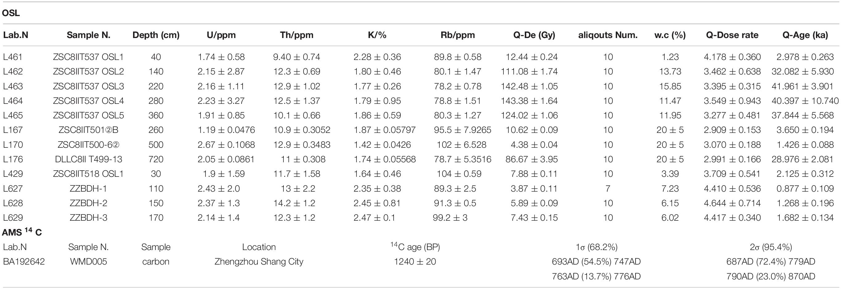
Table 1. Dating results.
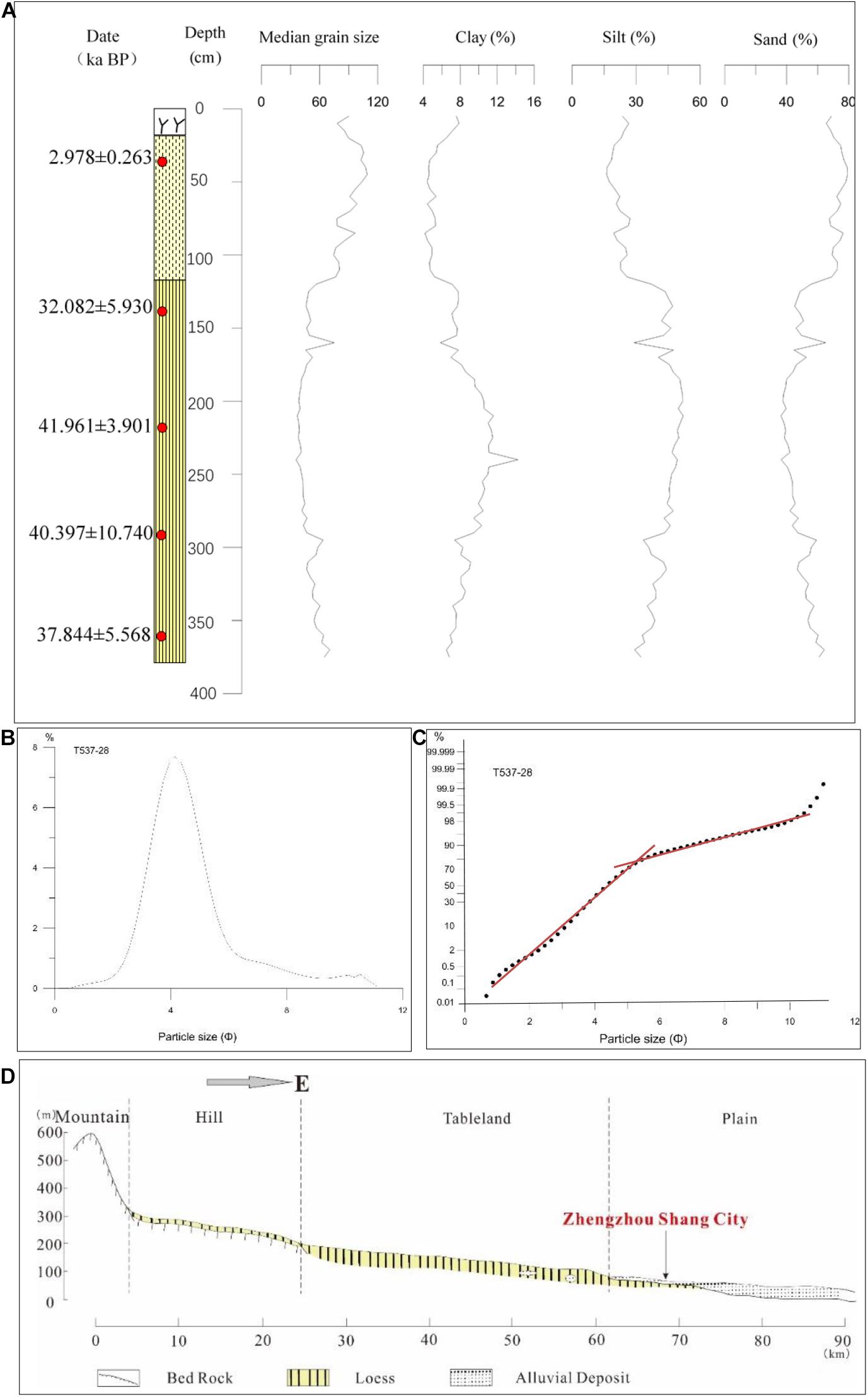
Figure 2. Particle size analysis (A) The particle size component of T537 profile in No.34 courtyard. The OSL ages are marked on the stratigraphic section according to the depth. Although the three ages are inverted in the bottom, all of them fall into the Late Pleistocene, and their errors are also within the appropriate range. (B) The frequency distribution curve of sample 28 (140 cm) of T537. (C) The probability cumulative curve of sample 28 of T537. (D) The geomorphic position of Zhengzhou Shang City.
Although the area of Zhengzhou Shang city was part of the loessic tablelands during the late Pleistocene, the distribution of loess does not continue much farther to the east. Liu (1992) found a thick alluvial stratum at the Zhacheng Site, around 10 km east of Zhengzhou. These deposits date to the late Pleistocene (Liu, 1992). At the Dahecun site, the alluvial strata date back to 12,000 BP (Yu, 2016). The date of these alluvial sediments east of Zhengzhou extend back into the middle-late Holocene (Liu, 1992; Yu, 2016). This corresponded to a famous ancient lake, Putianze, which is recorded in Chinese historical documents (Huang and Wang, 2014).
From the above analysis, we argue that Zhengzhou Shang city was located at the transitional zone between the loess tablelands and alluvial plain. According to the recovered sediments, the site area should be at the front of the loess tableland, which extended into the alluvial plain (Figure 2). During the Shang dynasty, people decided to locate their early capital in this area because of it had high ground, flat terrain, and was nearby to fresh water.
Unlike archeological sites in the countryside, most of Zhengzhou Shang city is covered by modern Zhengzhou. This complicates archeological and geoarchaeological work and required that our field work visit each point in the city. The field survey revealed that the terrain was not level. The prevailing topography, as evidence by locations like Zijinshan (ZJS in the Figure 3) and Erligang (ELG in the Figure 3), are higher in the west and lower in the east. There is an elevation difference of more than 10 m between the highest and lowest points in the city. However, the central part of the city is around 94 m above sea level.
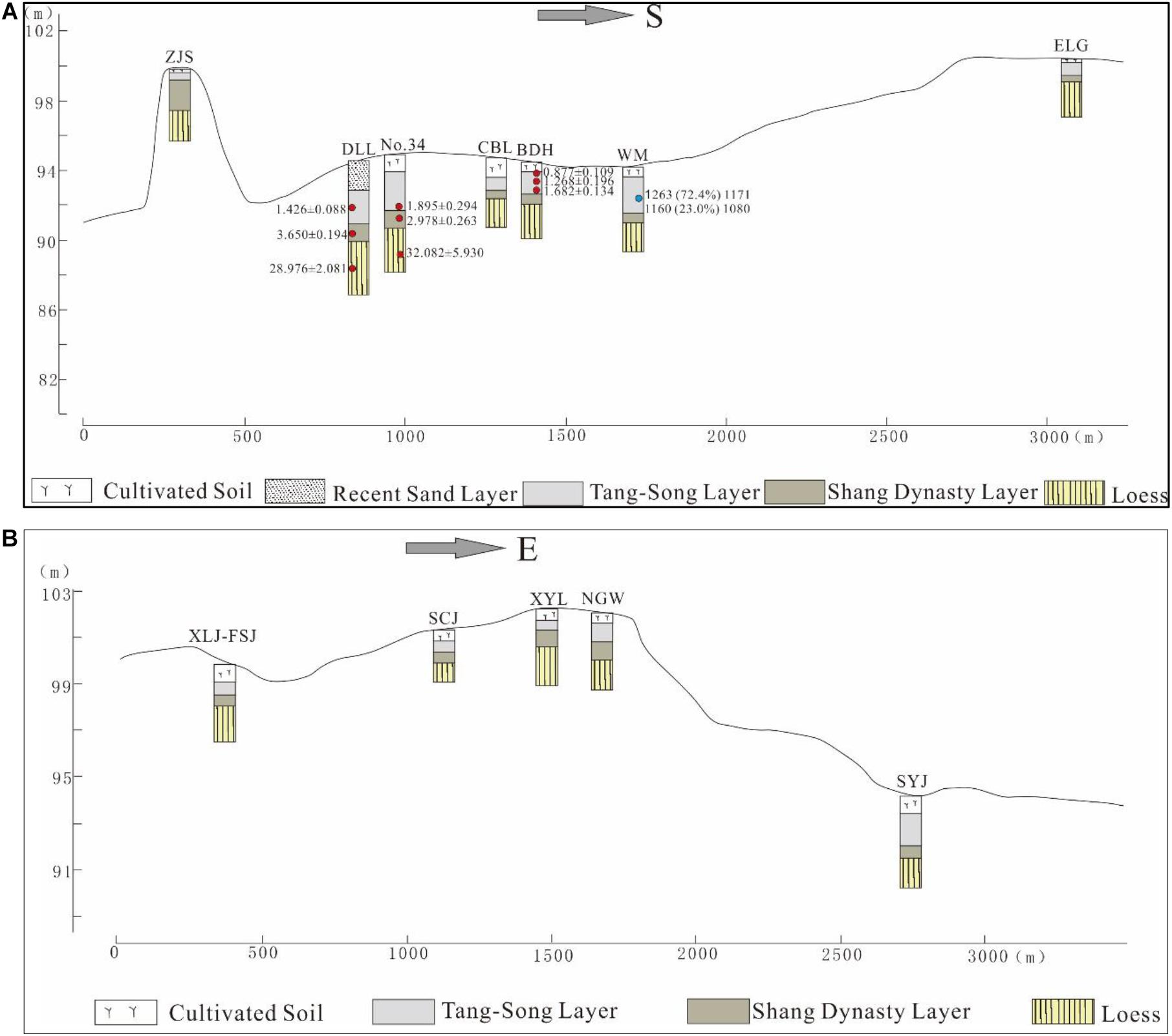
Figure 3. Topographic and sedimentary features in the region of Shang City (A). North - South; (B). West - East. The locations of excavation sites are showed in Figure 1B. The OSL (red circle) and 14 C (blue circle) ages are marked on the graph.
According to the ceramic chronology and our dating results, the strata at Zhengzhou Shang city can be divided into four phases (Figure 3). The uppermost layer is the recently cultivated soil or a disturbed layer. There is usually a sort of dark gray clay underneath this soil layer. Most cultural material in this clay layer dates to the periods of the Tang Dynasty (AD 618-907) and Song Dynasty (AD 960-1279). The dating results of this layer are also concentrated at ca. 1,200 BP (Figure 3). Therefore, we called this layer the Tang-Song layer. The underlying stratum is a yellowish silt which mainly contains Shang dynasty material culture. This layer dates to ca. 3,200 BP (Figure 3), and we named this layer the Shang dynasty layer. The lowest part of the strata is the ate Pleistocene loess. The dating results returned an age of around 10 to 40 ka. Although the thickness of the strata often changes depending on its geomorphic position, these stratigraphic sequences constitute a general sedimentary framework for the area around Zhengzhou Shang City.
According to the existing stratigraphic information and the regional depositions’ characteristics, we have simulated the topography of four periods, the late Pleistocene, the Shang Dynasty, the Tang-Song period, and the modern land surface of Zhengzhou (Figure 4). The results show that the general topographic features of the area have not significantly changed since the late Pleistocene. The area has always maintained a higher area in the southwest and lower area in the northeast. Due to the accumulation of sediment through both natural and human activities, the distribution of these elevated geomorphic units have continuously increased since the Shang Dynasty. These elevated geographic units are distributed in discontinuous patches across the plain and constrained the courses of the nearby rivers.
Figure 4. The simulation of the ancient topography. (A) Late Pleistocene. The terrain was lower than present. The early course of the Xionger River is clearly shown in the south. (B) Shang Dynasty. The terrain was higher than late Pleistocene. People built the city walls according to the terrain. (C) Tang-Song Periods. Areas of high elevation continued to increase. People built some new walls in the middle of city. (D) Modern. The area has always maintained the topographic characteristics of a high area in the southwest and low area in the northeast since late Pleistocene. The Xionger River is artificially altered with the straighter watercourse.
Our map of the ancient topography clearly shows the early course of the Xionger River to the south of the city. The ancient river course is different from the modern river course which has many recent artificial modifications. Although the early course of the Jinshui River to the north of city is not shown on these maps, the straight modern channel indicates that it has been artificially modified. According to the topographic features, the early Jinshui River should be located farther to the north than the modern channel.
The topographic simulation also provided key information to better understand the regional landscape evolution of the area around Zhengzhou Shang City. During 12000-10000 BP, the area exhibited transitional characteristics from loess tableland to alluvial plain (Figure 5). During the middle Holocene periods (8000-4000 BP), the regional hydrological conditions were favorable under the background of a warm and humid climate (Chen et al., 2015; Tan et al., 2020) and river aggradation (Lu et al., 2021). There were many natural water areas like lakes and wetlands. Some ancient settlements like the Minzhulu site and Peng Gong Jie site have been found on the elevated geomorphic units (Yan, 2016). During the early Shang dynasty around 3,600 BP, people came here to build a grand capital city with three layers of walls between the Jinshui River and Xionger River. After the climate changed and rivers incised their channels, many areas that originally had water disappeared, with the exception of a few lakes, like Putianze in the east. This is also consistent with the declining intensity of the summer monsoon on the Loess Plateau, as recently reconstructed from stalagmite records (Tan et al., 2020). From 2,000 to 1,000 BP, the size of the city shrank after it was no longer a capital. People built a smaller city that used part of the Shang dynasty walls in the southeast. Modern Zhengzhou city is located on the former site of the Shang City. As a result, the regional landscape, like the terrain and the rivers, has experienced significant changes over the past century.
Figure 5. The landscape evolution in the area of Zhengzhou Shang City (During 12,000-10,000 BP, the landform was changed to alluvial plain. During middle Holocene periods (8,000-4,000 BP), there were many natural water areas under a warm and humid climate and river aggradation (Chen et al., 2015; Tan et al., 2020; Lu et al., 2021). In 3,600 BP, the Shang city was built. During 2,000-1,000 BP, the city size was shrank and some watery areas disappeared, consistent with the declining intensity of the summer monsoon on the Loess Plateau (Tan et al., 2020). In the Modern, Zhengzhou city is located on the former site of the Shang City.
When we overlaid the activity areas of Zhengzhou Shang City on a regional terrain map from the Shang period, the results showed a close relationship between the natural landscape and these activity areas (Figure 6). The entire inner city was distributed on flat terrain. The palace area was located on the elevated region of the northeastern portion of the inner city. The sacrificial area was located in the highest southwestern part of the inner city. The distribution of workshops, including pottery, copper and bone artifact working areas, is located close to the rivers. The hoards were also located on the elevated geomorphic units.
Figure 6. The relationship between the topography and layout of Zhengzhou Shang City. The inner city was located in the flatter terrain. The palace, hoards and sacrifice area were arranged in the higher region. The workshops were close to the rivers.
Hou (2018) has argued that Zhengzhou Shang City went through three stages of urbanization. First, the palace city was built. Then, people constructed the inner city. Lastly, they constructed the outer city. During the early Shang dynasty, people built the palace and city walls on the higher and relatively flat geomorphic unit first. Afterward, they built the inner-city walls to protect key places like sacrificial sites. The highlands in the southwest are limited to the inner city. With the increase in settlement size, some of the workshops and hoards were placed outside the inner city to better use the terrain and water. Following this, people built the outer city walls around these workshops and hoards.
In many ways, the urbanization process of Zhengzhou Shang City occurred within the environmental context of the area. Favorable topographic and hydrological conditions in this transitional zone between loess tablelands and alluvial plains was an area well-suited for the construction of a capital city. As the city expanded in size, these topographic conditions began to affect the shape and structure of the ancient city. Both the hypotenuse of the northeast corner of the inner city and the nearly circular shape of outer city were influenced by the topography.
Although Zhengzhou Shang City gradually grew in size, the urban planning of the early city took into account the natural environmental context at that time. The key parts of the city were always arranged on the higher geomorphic units. The workshops were also distributed near the main water bodies. These locations reflect the fact that humans recognized and effectively used the natural environment during the early urbanization process (Tan et al., 2021).
In this study, we have analyzed the geomorphic location, terrain characteristics and types of landforms around the area of Zhengzhou Shang City. In this paper, we simulated and reconstructed the regional topographic and landscape evolution. We also discussed the relationship between the functional layouts of the early Shang period and the regional landscapes. The main conclusions are as follows:
(1) Zhengzhou Shang City was located in the transitional zone of loess tableland and plain. The geomorphic position belonged to part of the front of a loess platform extending into the alluvial plain.
(2) The regional topography of Zhengzhou Shang City was generally flat, but there have always been some areas with higher elevation in the area since the late Pleistocene. These units exhibit a distinctive patchy distribution in the plain and people have lived on them since the Neolithic.
(3) The urbanization of Zhengzhou Shang City went through a three phase developmental process, from palace city to inner city to outer city. Environmental factors played a key role in the process as the site selection were deeply influenced by topography, landform type and hydrology.
(4) The functional layout of Zhengzhou Shang City had a close relationship to the regional landscape. The key activity areas like the palace and sacrifice areas were always located on the higher elevated geomorphic units. Workshops were also distributed near the water. These cases reflect the fact that humans recognized and effectively used the natural environment during the process of early urbanization.
The original contributions presented in the study are included in the article/supplementary material, further inquiries can be directed to the corresponding author/s.
PC and PL designed the study and supervised the field work. PC, PL, SY, HZ, QW, and HW conducted the archeological investigations. XW analyzed OSL samples. JX analyzed particle size analysis samples. RY, MS, LY, and YT analyzed the data. PC drafted the initial manuscript, which was revised by PL and SY. All authors approved the final version.
The study is funded by the National Natural Science Foundation of China (Grant Nos. 41971016, 41671014, and 41701014), the National Social Science Foundation of China (Grant Nos. 18CKG003 and 19ZDA227), Science and Technology Project of Henan Province (Grant No. 192102310019), Soft Science Research Project of Henan Province (Grant No. 192400410067), the Study of Environment archaeology in Zhengzhou, the Digital Environment Archaeology Specially-appointed Researcher of Henan, China (Grant No. 210501002), the basic scientific research of Henan (Grant No. 210601042), and the Research on the Roots of Chinese Civilization of Zhengzhou University (XKZDJC202006), and the Science and Technology Think-Tank Project of Henan Academy of Sciences (Grant No. 210701002).
The authors declare that the research was conducted in the absence of any commercial or financial relationships that could be construed as a potential conflict of interest.
We thank the editor and two reviewers for their constructive suggestions.
An, J. H., and Yang, Y. B. (1983). The first excavation of the palace site in Zhengzhou Shang dynasty city. Cult. Relics 4, 1–14. doi: 10.1525/9780520941519-004
An, Z. M. (1954). Excavation of Zhengzhou Erligang in autumn of 1952. Acta Archaeol. Sin. 2, 65–107.
Ayala, G., Wainwright, J., Walker, J., Hodara, R., Lloyd, J. M., Leng, M. J., et al. (2017). Palaeoenvironmental reconstruction of the alluvial landscape of Neolithic Çatalhöyük, central southern Turkey: the implications for early agriculture and responses to environmental change. J. Archaeol. Sci. 87, 30–43. doi: 10.1016/j.jas.2017.09.002
Chang, H. Y. (2018). Analysis on the spatial planning of bronze casting workshop in capital cities during Xia-Shang periods. Cult. Relics Cent. China 5, 68–81.
Chen, F., Xu, Q., Chen, J., Birks, H. J. B., Liu, J., Zhang, S., et al. (2015). East Asian summer monsoon precipitation variability since the last deglaciation. Sci. Rep. 5:11186.
Chen, J. X., and Zeng, X. M. (1991). Investigation and excavation of outer rammed earth wall foundation of Zhengzhou Shang city. Cult. Relics Cent. China 1, 87–95.
Chen, Y. C. (1999). Zhengzhou Cultural Relics Chorography. Zhengzhou: Henan People’s Publishing House.
Getaneh, A., Haile, T., and Sernicola, L. (2018). Three-dimensional modelling of a pre-Aksumite settlement at the archaeological site of Seglamen, Aksum, northern Ethiopia using integrated geophysical techniques. Archaeol. Prospect. 25, 231–241. doi: 10.1002/arp.1705
HICRA (1993). Archaeological Discovery and Research in Zhengzhou Shang City. Zhengzhou: Zhongzhou Ancient Books Publishing House.
Hou, W. D. (2018). The urbanization process of Zhengzhou Shang City. Cult. Relics Cent. China 3, 36–62.
Huang, F. C. (2011). Analysis on the changes in settlements surrounding the site of Shang dynasty city in Zhengzhou and environment factors affacting the changes. J. N. China Inst. Water Conservancy Hydroelectr. Power (Soc. Sci.) 27, 101–103.
Huang, F. C., and Wang, X. G. (2014). The relationship between environment evolution of putianze and cultural geography during pre-Qin to Qin-Han periods. Agric. Archaeol. 1, 151–156.
Jiang, N., Wu, Q., and Li, G. Z. (2009). Excavation of Laofengang Shang dynasty site in Zhengzhou City. Cult. Relics Cent. China 4, 4–20.
Lai, Z., and Ou, X. (2013). Basic procedures of optically stimulated luminescence (OSL) dating. Prog. Geogr. 32, 683–693.
Liu, J. S. (1992). The preliminary research of the Holocene strata in Zhengzhou. J. Stratigr. 16, 111–119.
Liu, L. (2004). The Chinese Neolithic: Trajectories to Early States. Cambridge: Cambridge University Press. doi: 10.1017/CBO9780511489624
Liu, Y. F., Wu, Q., and Xue, B. (2010). A new investigation of the city layout and the trend of the outline wall of Zhengzhou in Shang Dynast. J. Zhengzhou Univ. (Philos. Soc. Sci. Edn.) 43, 164–168.
Lu, P., Lv, J. Q., Zhuang, Y. J., Chen, P., Wang, H., Tian, Y., et al. (2021). Evolution of Holocene alluvial landscapes in the northeastern Songshan region, Central China: chronology, models and socio-economic impact. Catena 197:104956. doi: 10.1016/j.catena.2020.104956
Lu, P., Tian, Q., Qiu, S., and Liu, C. (2014). The Pleistocene landform evolution and its drive force of the Suoxu river basin in Henan province. Areal Res. Dev. 33, 172–176.
Lu, P., Tian, Y., and Yang, R. X. (2013). The study of size-grade of prehistoric settlement in the Circum-Songshan area based on SOFM network. J. Geogr. Sci. 23, 538–548. doi: 10.1007/s11442-013-1027-5
Pan, M. J. (2010). The capital’s plan project and its influnce in early stage of Shang dynasty. J. Northwest Univ. (Nat. Sci. Edn.) 40, 708–712.
Qian, G. X. (2019). The research on the restoration of spatial pattern of Luoyang outer city in Northern Wei dynasty. Huaxia Archaeol. 6, 72–80.
Reimer, P. J., Bard, E., Bayliss, A., Beck, J. W., Blackwell, P. G., Ramsey, C. B., et al. (2013). IntCal13 and Marine13 radiocarbon age calibration curves 0–50,000 years cal BP. Radiocarbon 55, 1869–1887. doi: 10.2458/azu_js_rc.55.16947
Renfrew, A. C., and Bahn, P. (1991). Archaeology Theories Methods and Practice. New York, NY: Thamed and Hudson Ltd.
Schwerin, J., Richards-Rissetto, H., Remondino, F., Spera, M. G., Auer, M., Billen, N., et al. (2016). Airborne LiDAR acquisition, post-processing and accuracy-checking for a 3D WebGIS of Copan, Honduras. J. Archaeol. Sci. Rep. 5, 85–104. doi: 10.1016/j.jasrep.2015.11.005
Shi, Z. M. (1983). Natural Conditions and Resources of the Henan Province. Zhengzhou: Henan Scienceand Technology Press.
STCCG (1978). Particle Size Analysis and Application of Sedimentary Rocks. Beijing: Geological Publishing House.
Storozum, M., Lu, P., Wang, S., Chen, P., Yang, R., Ge, Q., et al. (2020). Geoarchaeological evidence of the AD 1642 Yellow river flood that destroyed Kaifeng, a former capital of dynastic China. Sci. Rep. 10, 1–12. doi: 10.1038/s41598-020-60169-1
Sun, Z. Y., Shao, J., Liu, L., Cui, J., Bonomo, M. F., Guo, Q., et al. (2017). The first Neolithic urban center on China’s north Loess Plateau: the rise and fall of Shimao. Archaeol. Res. Asia 14, 33–45. doi: 10.1016/j.ara.2017.02.004
Tan, L., Li, Y., Wang, X., Cai, Y., Lin, F., Cheng, H., et al. (2020). Holocene monsoon change and abrupt events on the western Chinese Loess Plateau as revealed by accurately dated stalagmites. Geophys. Res. Lett. 47:e2020GL090273.
Tan, L. C., Dong, G. H., An, Z. S., Edwards, R. L., Li, H., Li, D., et al. (2021). Megadrought and cultural exchange along the proto-Silk Road. Sci. Bull. 66, 602–610.
Wheatley, P. (1971). The Pivot of the Four Quarters- A Preliminary Enquiry into the Origins and Character of the Ancient Chinese City. Edinburgh: Edinburgh University Press.
Wu, P. F., Liu, D. X., Ma, J. H., Miao, C., Chen, L., Gu, L., et al. (2019). A geoarchaeological reading of the city-overlap-city phenomenon in the lower Yellow river floodplain: a case study of Kaifeng city, China. Sustainability 11:1029. doi: 10.3390/su11041029
Yu, G. (2016). Sedimentology of Lake-River Systems and Environmental Evolutions in Zhengzhou Regions. Beijing: Science Press.
Yuan, G. K. (2018). A brief discussion on the trend and age of the outer city wall of Zhengzhou Shang city. Cult. Relics Cent. China 3, 30–35.
Yuan, G. K., and Zeng, X. M. (2004). The relationship between inner city and outer city of Zhengzhou Shang city. Archaeology 3, 59–67.
Yuan, G. K., Zeng, X. M., Song, G. D., and Jia, L. M. (2004). Investigation and excavation of outer city in Zhengzhou Shang city. Archaeology 3, 232–242.
Zeng, X. M., Li, S. T., and Song, G. D. (2000). Excavition of the rammed earth walls in the palace area of Zhengzhou Shang city, Henan province in 1998. Archaeology 2, 136–156.
Zhang, G. S. (2018). The nature analysis of bronze hoard pits in Zhengzhou Shang city. Cult. Relics Cent. China 1, 53–59.
Keywords: Zhengzhou Shang City, landscape changes, ancient city arrangement, human-environmental interactions, geomorphic evolution
Citation: Chen P, Lu P, Yang S, Storozum M, Yang R, Tian Y, Wang H, Wu Q, Xu J, Wang X, Yan L and Zhai H (2021) The Impact of Ancient Landscape Changes on the City Arrangement of the Early Shang Dynasty Capital Zhengzhou, Central China. Front. Earth Sci. 9:656193. doi: 10.3389/feart.2021.656193
Received: 20 January 2021; Accepted: 03 March 2021;
Published: 25 March 2021.
Edited by:
Guanghui Dong, Lanzhou University, ChinaCopyright © 2021 Chen, Lu, Yang, Storozum, Yang, Tian, Wang, Wu, Xu, Wang, Yan and Zhai. This is an open-access article distributed under the terms of the Creative Commons Attribution License (CC BY). The use, distribution or reproduction in other forums is permitted, provided the original author(s) and the copyright owner(s) are credited and that the original publication in this journal is cited, in accordance with accepted academic practice. No use, distribution or reproduction is permitted which does not comply with these terms.
*Correspondence: Peng Lu, YnVsYXRlXzBAMTYzLmNvbQ==; Shugang Yang, d3lzeXNnQDEyNi5jb20=
Disclaimer: All claims expressed in this article are solely those of the authors and do not necessarily represent those of their affiliated organizations, or those of the publisher, the editors and the reviewers. Any product that may be evaluated in this article or claim that may be made by its manufacturer is not guaranteed or endorsed by the publisher.
Research integrity at Frontiers
Learn more about the work of our research integrity team to safeguard the quality of each article we publish.