 Siti Nur Fathiyah Jamaludin
 Benjamin Sautter
 Manuel Pubellier3
94% of researchers rate our articles as excellent or good
Learn more about the work of our research integrity team to safeguard the quality of each article we publish.
Find out more
ORIGINAL RESEARCH article
Front. Earth Sci., 25 February 2021
Sec. Structural Geology and Tectonics
Volume 9 - 2021 | https://doi.org/10.3389/feart.2021.588629
This article is part of the Research TopicFrontiers in Southeast Asian GeosciencesView all 17 articles
Using high quality regional seismic lines, we evidence major structures resulting from successive phases of tectonic events that affected the Luconia shelf from the Upper Cretaceous to Pliocene. Each tectonic event (Classified as Event 1–Event 3) is associated with different episodes of limestone growth in Luconia Province. The successive limestone growths are used as markers in constraining the timing and style of tectonic deformation. The poly-stage closure of the Proto South China Sea (PSCS) from the Upper Cretaceous to Lower Miocene led to the formation of compressional structures in its southern portion (South PSCS) providing elevated topography for the growth of the oldest limestone found in this area during the Upper Eocene to Lower Oligocene (Event 1). Based on contrasting seismic reflectors, morphology, and depositional patterns, the offshore Upper Eocene-Lower Oligocene limestone growth is correlated to the onshore Engkabang-Karap limestone. The southern part of Luconia was subjected to a continuous compression until the Lower Miocene at a time where the northern side of the Luconia Province was experiencing subsidence due to the rifting of the South China Sea (Event 2). The compression in the south generated elevated anticlines, triggering the growth of the Upper Oligocene to Lower Miocene limestone. By the end of the rifting event in the Lower Miocene, tectonic quiescence had enabled widespread carbonate growth in Luconia from the Middle to Upper Miocene. Regional compression due to the major uplift of Borneo hinterland (Event 3) triggered paramount clastic influx (gravity tectonics) to the offshore perturbating the limestone reef growth in Luconia. The impact of these interrelated shortening and stretching phases led to major crustal thickness variations and a prominent tilt of the Luconia platform that may highlight intricate feedbacks at the transition from compression to extension. While the southern side of the Luconia’s crustal fragment was anchored into Borneo hinterland, crustal extension in the northern region of Luconia led to a hyper-stretched crust characterized by low angle detachment faults and highly rotated blocks rising the mantle to its shallowest.
The Luconia Province in offshore Sarawak stands out as one of the oldest continental fragments drifted from the South China block through seafloor spreading and presently attached to onshore Borneo Island, particularly North Sarawak. It has been serving Malaysian as one of the highly explored oil and gas province for the past decades, particularly within the Middle to Upper Miocene limestone reservoir. The Luconia Block drifted from the South China block through seafloor spreading, that started in the southwest sub-basin at around 23.6 Ma based on the deep tow magnetic anomalies and IODP Expedition 349 cores (Li et al., 2014). The spreading ceased at about 16 Ma (Briais et al., 1993; Li et al., 2014) when part of Luconia’s crustal fragment collided with Borneo mainland (Hutchison, 2005). The closure of the southern portion of Proto-South China Sea (PSCS) (Rajang Sea) shortened dramatically the Rajang Accretionary Wedge inducing a major uplift onshore Sarawak. This was followed by denudation of the topography during the post-collision relaxation phase. By the Oligocene, the drifted Luconia continental fragment experienced rifting of the South China Sea, with a major crustal stretching affecting the north of the block (Savva et al., 2014) while, synchronously a major crustal shortening occurred in the south. This event was pursued by a tectonic quiescence where the most explored limestone reservoirs were deposited within the Central Luconia and its surrounding, before their demise in the Upper Miocene, attributed to the regional subsidence all over the South China Sea and Pliocene compression and uplift in Sabah (Kessler and Jong, 2015). Contrasting structural fabrics are preserved in different parts of Luconia Province, owing to a tight succession of tectonic events. While the southern region is dominated by a large-scale fold and thrust belt, the northern side is characterized by horst and graben structures bounded by low angle normal faults. Coincidently, the shape, geometry and orientation of the limestone build-ups varies in difference parts of Luconia (Figure 1A). It is known now that most of the Luconia limestone build-ups grow on tectonic high structures (Koša, 2015; Jamaludin et al., 2018) and formed as pinnacle-conical shape build-ups, commonly grow in the southern Central Luconia, and elongated build-ups commonly found within the central section of the province. Meanwhile, the northern section of Central Luconia is proven to host larger and rounded shape carbonate build-ups (ie: Mega Platform) (Ting et al., 2011). In this paper, we demonstrate a close relationship between major vertical motions during regional tectonic events and the growth of limestone build-ups in Luconia by utilizing the carbonate biostratigraphic markers, strontium dating and regional seismic profiles to reconstruct the structural evolution of the studied area. This paper presents different phases of limestone growths during the Tertiary as the key markers in constraining the timing and style of deformational events in Luconia Province from the Eocene to Pliocene.
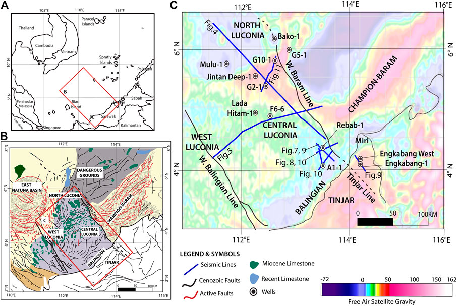
FIGURE 1. (A) Location of the study area within the South East Asia setting with rectangle highlighting the map in (B). (B) The geological provinces in offshore Sarawak, divided by major Cenozoic and recent faults. Middle to Upper Miocene and recent limestone build-ups are common in the Central-West-North Luconia Provinces. Map in (C) is highlighted in (B). (C) 2D seismic lines presented in this study, with the well locations are shown, overlay with satellite gravity from Sandwell and Smith, (1997).
A very large partially published database provides the details on the Miocene limestone of Luconia, but very little record the relationship between limestone deposition and the tectonic evolution of this area remains poorly understood. With an access to unpublished high resolution regional seismic data and selected deep wells (Figure 1B), we further explore the evidence of limestone deposition from the surrounding regions, including the Balingian-Tinjar Provinces to establish the contingency of different tectonic events and transition from one event to the other. A comprehensive geological model illustrates the incidence of the three geological events (Event 1–Event 3) on the regional structures and limestone growth episodes discussed in this paper.
The Luconia Province in offshore Sarawak is divided into its’ geographic position of North-, Central- and West- Luconia Provinces based on geo-tectonic characteristics of the basins. This region was heavily faulted during the Cretaceous-Oligocene (Figure 1A) owing to the evolution of the South China Sea (SCS). Present-day, active faulting due to gravitational tectonic are common in the Champion-Baram delta, West Luconia and East Natuna basins (Figure 1A). Among those, Central Luconia Province is characterized by prolific carbonate reservoirs that varies in the build-ups size, shape and orientation (Figure 1A). The carbonate reservoirs are often drilled within the Middle and Upper Miocene limestone sections and have been individually described predominantly in terms of sedimentology and reservoir properties (Epting, 1980; Ali and Abolins, 1999; Vahrenkamp, 1996, 2004; Gartner et al., 2004; Zampetti et al., 2004a; Ting et al., 2010; Ting et al., 2011; Koša, 2013; Koša, 2015; Hamdan and Jamaludin, 2018; Warrlich et al., 2019).
The Sarawak Basin is filled with post-Middle Eocene sediments that unconformably deposited above the Rajang Accretionary Prism (Madon et al., 2013). The evolution of the Sarawak basin began in the Upper Cretaceous-Eocene, through rifting of the southern margin of the South China, originating from the underplating of the Proto-SCS underneath Borneo. The effects of the underplating are seen along the Rajang Fold-Thrust Belt which covers much of Sarawak and continues into Sabah (Balaguru and Hall, 2008; Hall and Breitfeld, 2017; Chang et al., 2019). In Sarawak, the closure of Proto-SCS or locally known as the Rajang Sea took place since Upper Cretaceous and the spreading completely stopped by the Middle Miocene (Chang, 2020 and references herein). This event lead to the formation of Rajang Accretionary Wedge and induced a first collisional-compressional episode on the Sarawak inland. However, evidence for the ancient subduction zone beneath present-day Sarawak is almost entirely lacking (Cullen et al., 2013; Hall and Breitfeld, 2017). According to published studies, the collision had initiated the development of a post-orogenic foreland basin (Mat-Zin, 1996; Madon, 1999; Hesse et al., 2009) with molasse deposits in the post-Oligocene evidenced by shallow marine shelf progradation. Since the Upper Miocene, a succession of inversion and uplift events took place across the Sarawak basin. At the same time, denudation of the hinterland of Sarawak through weathering processes had generated a large amount of sediments that were transported through deltaic systems to the offshore basin of Sarawak, inducing a gravitational collapse of this unstable pile of sediments (Sapin et al., 2013; Pubellier and Morley, 2014; Jamaludin, et al., 2014; Ilao et al., 2018; Jamaludin, et al., 2018).
Central Luconia is separated from the Baram-Balabac Basin in the east and the Dangerous Grounds in the northeast by an outstanding tectonic feature known as West Baram Line (WBL), a 50 km wide fault zone (Cullen, 2014) (Figure 1A). The onshore extension of the WBL was interpreted to be the Tinjar Line (TL) (Figure 1B) highlighting the northern boundary of the Luconia crustal fragment that collided with Borneo during Lower-Middle Miocene (Sapin et al., 2011), thus closing a part of the Proto- SCS. Both fault lines appear to have been episodically reactivated during the Cenozoic. To the west of Luconia Province is the West Balingian Line. It is easily recognized on regional gravity anomalies map where a discontinuous line of narrow elongated grabens (Mat-Zin, 1996), marks the boundary between Central and West Luconia Provinces.
The lithostratigraphy in the offshore Sarawak is defined by Cycle nomenclature, from Cycle I to VIII (Figure 2), where Cycle I being the oldest sediments recorded. The base of Cycle I was defined as the Rajang or Sarawak Unconformity at approximately 39 Ma (Ho, 1978; Hageman et al., 1987). Deep marine sediments are also found in Cycle I until the Lower Miocene, where the facies evolve to shallower depositional environments. Sedimentation began with non-marine to coastal plain sediments within Cycle I and II (Lower Miocene (24–19 Ma) (Ho, 1978; Hageman et al., 1987) and having more marine influence from Cycle III (Upper Lower Miocene to Middle Miocene (18–16 Ma) (Madon et al., 2013). Tatau and Nyalau formations of central onshore Sarawak are regarded as equivalent to the offshore subsurface of Cycle I and II. Cycle III and younger units do not have onshore equivalents in Sarawak except in the Miri area, where Upper Miocene-Pliocene deformation uplifted part of the delta (Morley et al., 2003; King et al., 2010).
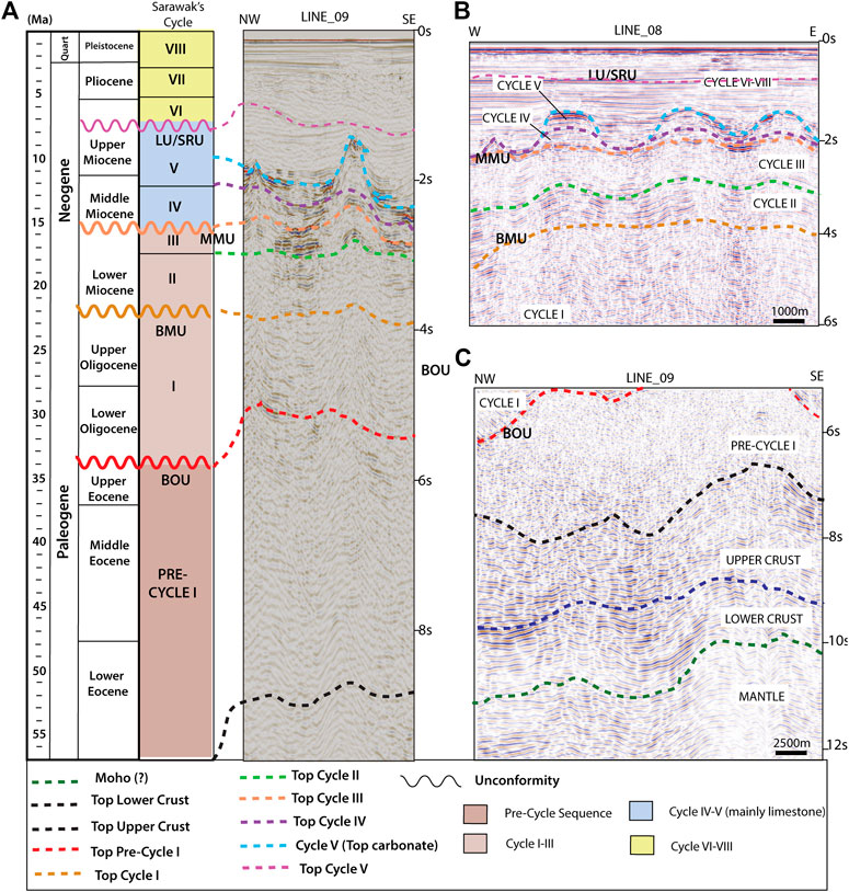
FIGURE 2. (A) Seismo-stratigraphy chart of this study correlated with Sarawak’s stratigraphy based on Ho (1978) and Hageman et al., (1987). Four major unconformities are base Oligocene Unconformity (BOU), base Miocene Unconformity (BMU), Middle Miocene Unconformity (MMU) and Lapan Unconformity (LU) which is equivalent to Shallow Regional Unconformity (SRU). (B) Horizons and seismic facies for Cycle I to Cycle VIII. (C) Horizons and seismic facies for the mantle, lower-upper crust and Pre-Cycle I sequence.
Several unconformities were recognized in this region and they represent regional tectonic events which took place during a short time (Steuer et al., 2014; Morley, 2016). However, the identification of unconformities in the southern part of the SCS including Luconia and Dangerous Grounds remains a challenge because of their diachronous nature and influenced by the uplifting and erosional events (Steuer et al., 2014), For example, the Breakup Unconformity (BU) which indicates the transition from rifting to drifting gets younger in SW direction following the propagating rift (Franke et al., 2014). The age approximation for BU in northeast is close to the Eocene-Oligocene boundary at 33.9 Ma (Lunt, 2019) based on the age-depth plot of Li et al. (2014) and Larsen et al. (2018), and younger (28–23 Ma) in the southwestern part of the SCS (Barckhausen et al., 2014). To tackle this issue, the efforts to correlate the unconformities across the southern part of the South China Sea using biostratigraphy constrained is on-going (ie: Lunt, 2019; Lunt, 2020; Morley et al., 2020) and these works will greatly improve the understanding of basin evolution in the region.
The Oligocene- Miocene boundary at 24–22 Ma is marked by a prominent unconformity known as the Top Crocker Unconformity (TCU) (van Hoorn, 1977; Hazebroek and Tan, 1993; Hall et al., 2008; Cullen et al., 2010; van Hattum et al., 2013) in the onshore or equivalent to the base Miocene Unconformity (Figure 2) (BMU). In this paper, we will use the term BMU. BMU marks the onset of collision (Morley, 2016) with a transitional period of about 5–7 Ma or 4–9 Ma (Lunt, 2019) between the onset of subduction of continental crust and final jamming of the subduction zone in NW Borneo. The recognition of the BMU stands out and is relatively easy to date and differentiate with strong facies change as seen in Mulu-1 well in North Luconia (Madon et al., 2013; Lunt and Madon, 2017; Lunt, 2019).
Another profound unconformity and traceable event in the whole southern SCS including Sarawak is the Middle Miocene Unconformity (MMU) (Figure 2) that marks the boundary of Cycle III and IV. The term Middle Miocene had led to misinterpretation or misplaced of the interpretation for this unconformity, as interpreters have the tendency to interpret the unconformity in the Middle Miocene, as seems to befit the name (Lunt and Madon, 2017). Doust (1981) described the Sarawak MMU as the most important subsidence event that commenced in middle Miocene time, at the same time as the subsidence in the China basin, along a network of NNW-SSW trending normal faults. An updated age constrain of this unconformity was finally available when Krebs (2011) conducted graphic correlations of biostratigraphic data from over 70 wells in the whole Sarawak margins and found the age of the unconformity to be Upper Lower Miocene (∼17–19 Ma). The MMU has been informally re-named as the Early Miocene Unconformity (EMU) in Madon et al., (2013). Many wells in the offshore Sarawak see major changes in the lithofacies between the rocks of Pre-MMU (predominantly Cycle III rocks) with a consistent increase in clay and shale associated with a reduction in sands, silts and calcareous sediments, which suggests a sudden subsidence and a sharp reduction in rate and energy of sedimentation (Madon, 1999; Lunt and Madon, 2017).
At the end of Cycle V, at about 8 Ma, a major event overseeing the demise of Luconia limestone, is associated with rapid uplift of onshore Sarawak and increase of sediment supply to the offshore, hence disturbing the Luconia carbonate production. This event corresponds to the Lapan Unconformity (Figure 2) (Lunt, 2020), a regional expression of what is locally recognized in northern part of Borneo as the Shallow Regional Unconformity (SRU) (Levell, 1987).
Regional seismic (2D) profiles and deep-seated wells across Central Luconia Province were utilized in this study (Figure 1B). Some of the seismic lines encompasses subsurface information from the neighboring provinces which include the North Luconia, West Luconia and Balingian Provinces, which gives an advantage in the interpretation of the regional structural framework. The 2D seismic profiles were acquired by several companies including Schlumberger and Shell in the late 1980s to 1990s and been reprocessed between 2010 and 2012. The seismic data was processed by several companies which include CGG, Veritas and Shell. The data went through standard routine processing which include noise removal using low-cut, hi-cut filtering and Tau-P attenuation, followed by removal of multiples using Surface Related Multiple Attenuation (SRME) and Radon Demultiple. Finally, the data went through Kirchoff Pre-stack Depth Migration (PSTM) before stacking for interpretation. Integration of published seismic images in this region have been used to improve the understanding on the regional framework and guide our interpretation. Well to seismic tie was performed on five deep wells that reached Cycle I and/or Cycle II. These wells are in the south, central and north of Central Luconia Province, thus providing a solid subsurface correlation for the entire study area. In this study, the well tops are labeled based on the Sarawak Stratigraphic Cycles (Cycle I–VIII) in each of the wells. Lada Hitam-1 and F6-6 wells (Figure 3) in the central zone of Luconia Province produced a good correlation between the seismic wavelets’ response and synthetic seismogram. Both wells are used as control points for regional seismic interpretation. Accurate age controls based on biostratigraphy from the wells are calibrated with the seismic within the Lower Miocene to recent sediments and subsequently correlated laterally. A total of eleven horizons were picked to represent the offshore Sarawak sedimentation. This include the seabed, Cycle VI–VIII, Cycle V, Cycle IV, Cycle III, Cycle II, Cycle I, Pre-Cycle I, Upper Crust, Lower Crust, and the Moho. Moho, Upper and Lower Crusts horizons are is only visible in a few deep and long seismic lines (Figures 4, 5). Geological interpretation of the seismic data was conducted based on the latest review of Sarawak’s stratigraphy by Lunt and Madon (2017), and incorporated markers from the key wells (Figure 1B).
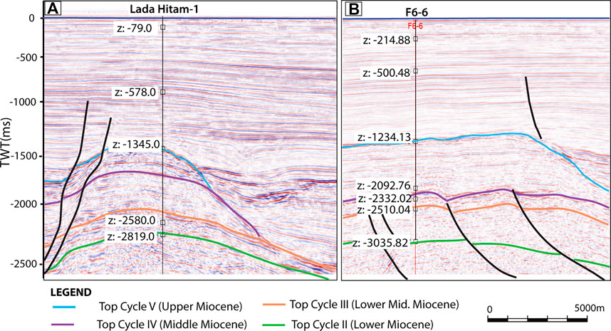
FIGURE 3. Seismic and well correlation for time-depth conversion for Lada Hitam-1 and F6-6 wells in the central part of Luconia Province provide confidence in interpretation of the seismic data. The depth values (Z) for both wells are labelled with corresponding interpreted seismic horizons.
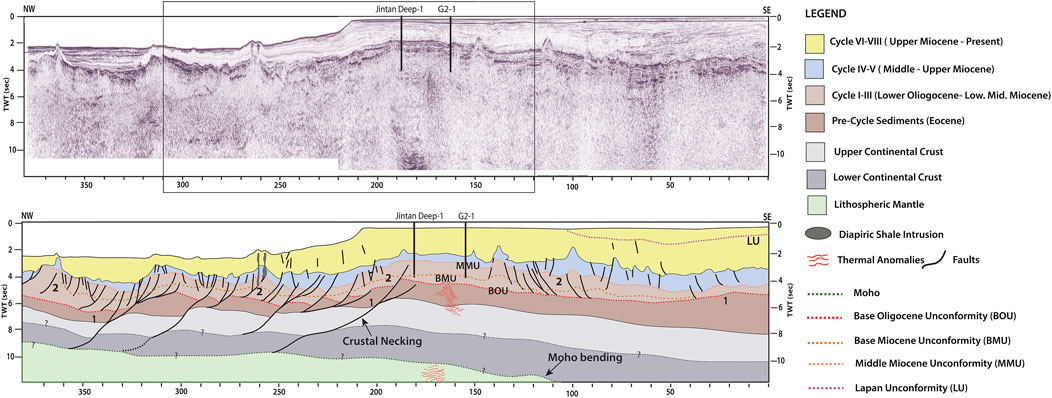
FIGURE 4. Uninterpreted and interpreted seismic line across N-S of Luconia Province. The northern part is having low angle detachment faults and thinner crust in boudinage shapes while the southern part exhibit high angle normal faults and thicker crust. Thermal anomalies are observed at point of crustal necking between shallow and deep-water section with Moho seen to bend into the subsurface. Location of the line is shown in Figure 1B. Rectangle box is representing the zoom in section for Figure 6. Numbering 1 and 2 are corresponding to the tectonic events discussed in this paper.
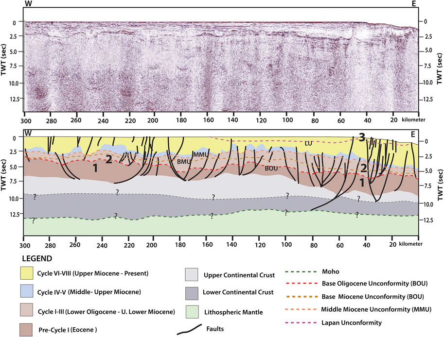
FIGURE 5. Uninterpreted and interpreted seismic line across E-W of Luconia Province. The western part has thicker crust compared to eastern side. More high angle normal faults are seen in the eastern section within Cycle VI–VIII sequences. Location of the line is shown in Figure 1B. The numbering 1–3 are corresponding to the tectonic events discussed in this paper.
Like most of the sub-basins in the southern South China Sea, the Luconia Provinces are filled with Cenozoic sediments with abundant of Middle to Upper Miocene carbonate build-ups. Horizons are labeled based on Sarawak’s stratigraphic cycles and grouped into three mega-sequences, “Pre-cycle I,” “Cycle I-III” and “Cycle IV-Present” (Figure 2) to relate with the sediment deposition and tectonic events at a particular time frame. Accompanying Table 1 summarized the seismic expression characteristics that are used to differentiate the seismic sequences. In this work, we have interpreted four unconformities. These unconformities are the base Oligocene Unconformity (BOU) at 30–32 Ma, dividing the top section of Pre-Cycle I sediments with overlying Cycle I sediment. The second unconformity observed is base Miocene Unconformity (BMU), marked at 22–23 Ma. The appearance of BMU is seen as changes in the seismic facies from hummocky with low amplitude section at the top of Cycle I to sub-parallel and moderate amplitude Cycle II sediments. The third recognized unconformity is the Middle Miocene Unconformity (MMU), dividing Cycle III and Cycle IV sediments and lastly, the Lapan Unconformity at approximately 8 Ma and is interpreted mainly in the southern part of the study area. A detailed description of these unconformities is described in the seismic sequences sections on this paper.
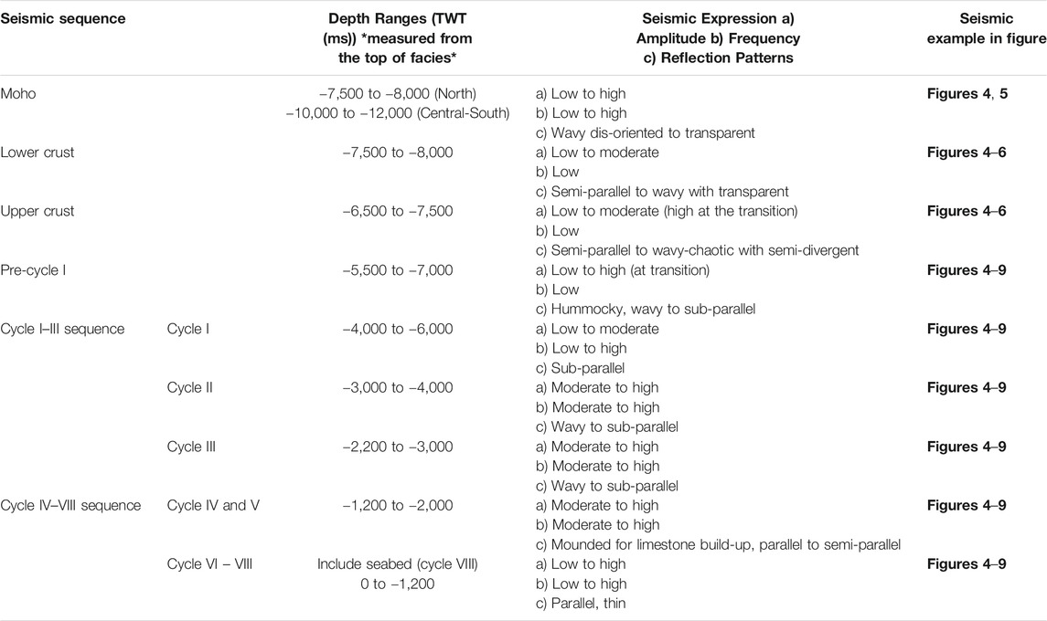
TABLE 1. Summary of the characteristic and seismic expression for each seismic sequence interpreted in this paper.
The lower and upper crust for the Luconia Province is hardly documented because of limited depth coverage of the seismic data. With the privilege to interpret several long and regional seismic lines, we documented the lower and upper crust of Luconia Province as homogenously thick in the central to southern parts of the province. The crustal layers are faulted and formed as boudinage shape in the deep-water section of the province (North Luconia). The top of the crust is interpreted at depth between −6,500 and −7,500 ms (Figures 4, 5). The top of the upper crust is determined by its high amplitude with semi-divergent reflectors (Figures 6, 7). Within the crust, strong amplitude reflectors are clustering in few sections where the listric faults terminate. Although the quality of the reflectors at depth are poor, a clear transition between two seismic facies is observed. Additionally, the lower crustal unit has clear ductile boudinage features whereas the upper crust is affected by clear brittle offsets along the listric normal faults (Figure 4). The Moho is imaged in few seismic profiles (Figures 4, 5). In the deep-water section, the Moho layer is detected to be shallower at −7,500 to −8,000 ms while it is picked at −10,000 to −12,000 ms elsewhere in the Luconia Province. The transition of different depth for the Moho is seen as a major crustal necking between the shallow and deep-water section of Luconia Province. Coincidently, high amplitude reflectors stacking on top of each other at depth approximately −5,000 to −7,000 ms are observed underneath G02-1well (Figures 4, 6), at point where the Moho reflectors disappear at depth. This crustal necking (Figure 4) is also evidenced through thermal anomalies, reported by high Hydrogen Sulfide (H2S) in the G02-1 well (Shell, 1989). The thermal anomalies appeared as very high amplitude, strong frequency with wavy to chaotic reflectors are seen in the mantle. It appears similarly in the crust layers and Pre-Cycle unit at the same positions seen in the mantle (Figures 4, 6).
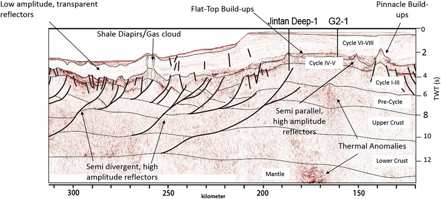
FIGURE 6. Zoom in section from Figure 4 to highlight the geological features interpreted including the shale diapirs, seismic facies and characteristics of limestone build-ups in Luconia.
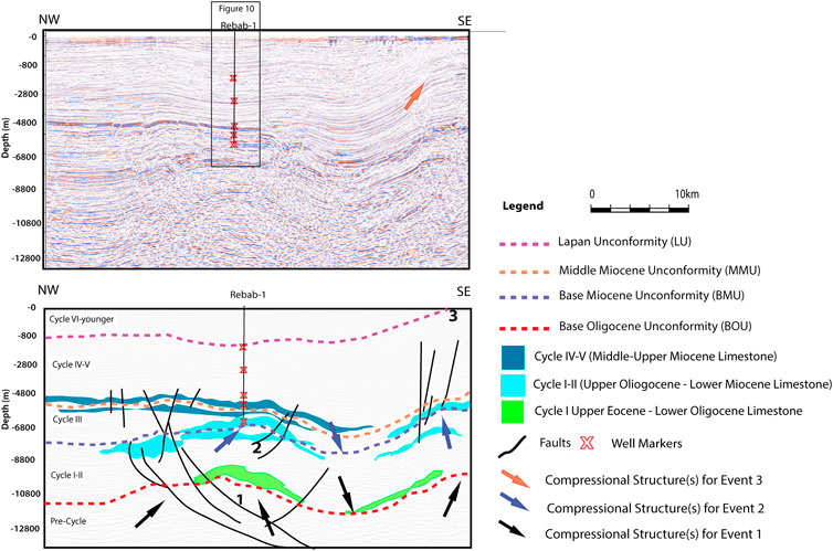
FIGURE 7. Seismic line oriented in NW-SE, crossing Rebab-1 well. Interpretation of Middle Miocene limestone is based on the well-seismic correlation and guidance of geophysical characteristics of the reflectors. The Upper Oligocene and Upper Eocene limestone are interpreted based on the geophysical characters. Location of the line is shown in Figure 1B. Annotation 1–3 are referring to Event 1–3 discuss in this paper.
The Pre-Cycle I sequence was deposited during the Eocene. It is known to overlay the Pre-Tertiary upper and lower crusts. No wells penetrate to the sediments in Pre-Cycle I sequence; thus, the interpretation is fully based on the seismic response. The seismic reflectors within Pre-Cycle sequence are subjected to a resolution loss due to dispersing wave energy. Parallel, moderate amplitude reflectors are visible at the transition between the Top of Pre-cycle I and the base of Cycle I. Within the Pre-Cycle I sequence; the seismic reflectors are weak and show hummocky textures with transparent patches which are observed at faults terminations.
Sediments in the Pre-Cycle I sequence appears in wedge-shaped and controlled by the thrust faults (Figure 4). The top of Pre-Cycle sediment in the southern part of Central Luconia is marked as bright amplitude with sub-parallel reflectors, covered by low amplitude, low frequency chaotic reflectors (Figures 6–8). Pre-Cycle I sequence is overlain by base Oligocene Unconformity (BOU) (Figure 2). The BOU is interpreted at depth −5,000 ms or approximately at depth 10,500–12,000 m. It appears as parallel to sub-parallel with moderate amplitude reflectors dividing the Pre-Cycle I and Cycle I sediments. Toward the south of Luconia Province, appearance of BOU is more prominent with high amplitude reflectors. The BOU in the south of the province is interpreted at the top of anticlinal structures (Figures 7–10). Changes in seismic facies is observed at the top of Pre-Cycle sediment and the overlying Cycle-I sediment, and this is useful in marking the base Oligocene Unconformity (BOU) in the data.
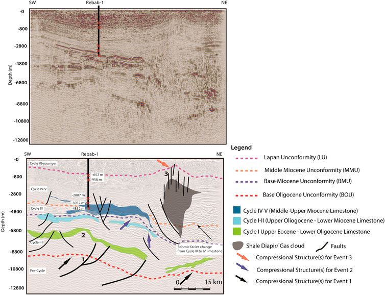
FIGURE 8. Seismic line oriented in SW-NE, crossing Rebab-1 well. Interpretation of Middle Miocene limestone is based on the well-seismic correlation and guidance of geophysical characteristics of the reflectors. The Upper Oligocene and Upper Eocene limestone are interpreted based on the geophysical characters. Shale diapir is seen to seep from Early Miocene sediments (Setap Shale) to the younger sediments through faults. Location of the line is shown in Figure 1B. Annotation 1–3 are referring to Event 1–3 discuss in this paper. The depths in meter (m) are representing the well to seismic tie values for the seismic markers.
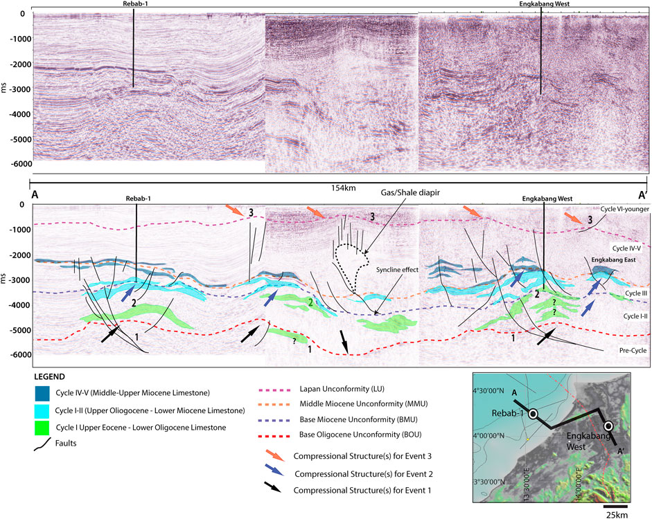
FIGURE 9. Above) Correlation of seismic line in Figure 7 with a control line from offshore to onshore in Engkabang-Karap Anticline of Tinjar Province. Below) Interpreted section of the correlation of seismic line in Figure 7. The annotation 1–3 is referring to Event 1–3 discuss in this paper. Upper Eocene to Middle Miocene limestone successions are observed at almost similar depth in the offshore and onshore. The interpretation of Engkabang West anticline is guided by Jong et al. (2016). Inset map is showing the orientation of A-A′ line from offshore to onshore.
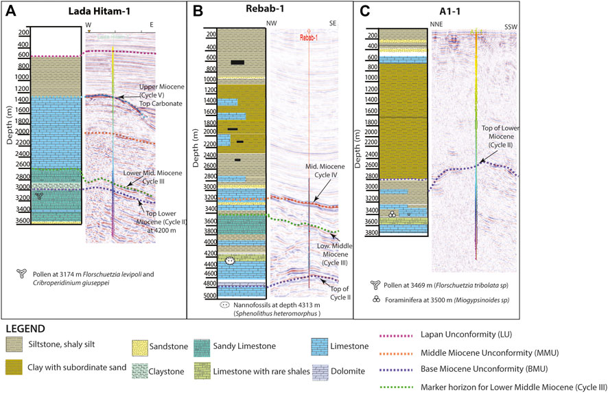
FIGURE 10. Correlation of lithological interpretation (from the core and cuttings) and seismic interpretation of (A) Lada Hitam-1 well; (B) Rebab-1 well; and (C) A1-1 well. Pollen and nannofossils found in the rock samples are annotated in the lithological logs, giving more confidence in the age control.
In the North Luconia, the Pre-Cycle I sequence is characterized by a relatively massive sediment at thickness equal to 2 km (Figures 4, 6). However, the same sequence appears much thicker in the southwest and central section of the province, ranging from 3 to 5 km in thickness (Figures 4, 5).
Cycle I to III are group together as a single sequence representing the sedimentation from Lower Oligocene to Lower Miocene (Figure 2) considering the timing of deposition and similar structural patterns found within Cycle I–III. The depth of marker for Cycle I is interpreted at −4,832 m (−3,250 ms) based on Rebab-1 well (Figure 10B) in the south of Central Luconia. The seismic reflectors within Cycle I are showing thin patches of high amplitude and high frequency reflectors (Figures 2C, 6). The high amplitude, high frequency reflectors are surrounded by sediments that give response of low amplitude most probably shale or mud-dominated rocks. The boundary of Cycle I and II is marked by the Base Miocene Unconformity (BMU) (Figure 2). BMU is recognized based on the facies changes from moderate to low amplitude reflectors in Cycle I (Upper Oligocene) to bright amplitude in Cycle II (Upper Miocene). The seismic markers for Cycle II and III have strong amplitude, high frequency reflectors with wavy to sub-parallel patterns (Figures 2B, 6). The sedimentation of Cycle I–III is thickening toward the north of Luconia with isochron map of Cycle I–III sequence shows a thickness of 800–1,500 m in the southern to central part of Luconia and 1,400 to 2,000 m of sediments in the north.
The top of this sequence is interpreted as Middle Miocene Unconformity (MMU), at the boundary of Cycle III and Cycle IV unit. The MMU is marked based on the high amplitude response at the top of Cycle III. The high amplitude response on MMU is related to the changes in high velocity response within the younger cycles at the top with lower velocity sediments in Cycle I to III sequence. The lithology of Cycle I to III sequence is analyzed based on core data of four deep wells: A1-1 and Rebab-1 in the south and Bako-1 and Jintan Deep-1 in the north. Cycle II sediments in the south of Central Luconia toward the Balingian Province consists of limestone with rare shales as seen in Rebab-1 and A1-1 wells. The lithology of Cycle I in the north of Central Luconia is dominated by limestone with dolomite in the upper part of Cycle I followed by increasing appearance of sandstone and shales interbedded with the limestone (Shell, 1972; Lunt, 2019). At the base of Bako-1 well in North Luconia Province, a gradual transition from hemipelagic chalks to deep marine clays is observed (Madon et al., 2013).
This sequence includes sediments deposited in Cycle IV to Cycle VIII, dated from Middle Miocene to present-day. Cycle IV and V sediments show characteristics of moderate to high amplitude with sub-parallel reflections. Locally mounded and chaotic reflections are also common. Small scale faulting intercepts with the deposition of Cycle IV and V sediments. Commonly, Cycle IV is dominated by widespread limestone that grows into pinnacle and flat top carbonate buildups (Figures 4–6). This is recognized in the seismic based on the rapid changes in the amplitude at the top of the limestone buildups. The high amplitude, high frequency (thick) reflectors in mounded shape are also notable within Cycle V at the Central and North Luconia Provinces as limestone continued to deposit. However, in the southern part of Luconia, Cycle V shows moderate amplitude with low frequency (thin) reflectors in parallel-straight shape (Figures 2B, 6). The difference in seismic response of Cycle V sediments in the central-north and south of Luconia indicate more siliciclastic sediments (ie: siltstone, shaly silt and sandy silt/shale) were deposited in Cycle V within the southern part of Luconia. This is confirmed by the gamma ray logs and cores of Rebab-1 and A1-1 wells (Figures 10B,C). Meanwhile, the seismic responses recorded within Cycle VI–VIII are having low frequency, moderate to high amplitude with laminated parallel seismic facies (Figures 2B, 6). In the central to northern part of Luconia, low amplitude, almost transparent sections are identified within the sediments deposited in Cycle VI–VIII (Figure 6).
The base of Cycle IV–VIII sequence is a continuous reflector of MMU, as explained in Cycle I–III Sequence. Within Cycle IV–VIII sequence, there is one notable reflector that shows changes from low amplitude, low frequency, and weak seismic response to strong layering with high amplitude reflectors. It is mark as an unconformity within the post-rift sequence at the transition of Upper Miocene to Lower Pliocene sedimentation (Figure 2) annotated as the Lapan Unconformity (LU). Lapan Unconformity is traceable in few seismic lines in the south and central of Luconia Province, with more profound appearance at the southern region (Figures 7–9).
Generally, the carbonate build-ups within Central Luconia and its surrounding basins are recognized based on the high amplitude and high frequency seismic reflectors, along with distinguished morphology of a flat-top elongated build-ups or conical shape with stringers on both sides of the build-ups (ie: Figures 2B, 6). Most of the Middle-Upper Miocene carbonate build-ups served as prolific reservoirs for the hydrocarbon, and their exploration wells have recovered valuable cores. Multiple wells penetration allows reliable age determination among the sediments in Cycle IV–Cycle VIII, including the Middle- Upper Miocene carbonate. Despite the extensive Middle-Upper Miocene carbonate buildups that are always been highlighted; older carbonate build-ups are also preserved within the Luconia Province. The carbonate growth in Central Luconia from the Upper Eocene to Upper Miocene is presented in the following section.
In the south of Central Luconia, seismic reflectors showing possible limestone deposition are found as deep as −8,000 m (approximately at −4,000 ms) and located at the core and limbs of the anticlines within Cycle I sediments (Upper Eocene–Upper Oligocene) such that found underneath the Rebab-1 and A1-1 wells (Figures 7–9). This is only seen on seismic and are not confirm by any drillings since the exploration wells did not drill to this depth. Based on seismic profile, the Eocene- Oligocene limestone tend to grow on top of humps at the anticlines and expand laterally instead of growing vertically as usually seen in the younger Miocene build-ups of Central Luconia (Epting et al., 1980; Zampetti et al., 2004a; Zampetti et al., 2004b; Jamaludin et al., 2014; Koša, et al., 2015). However, the earlier growth of limestone within the Upper Eocene-Lower Oligocene in Central Luconia is not commonly illustrated due to limited data as well as its’ distribution is skewed toward the onshore. The potential Upper Eocene-Lower Oligocene limestone interpreted underneath Rebab-1 and A1-1 wells (Figure 9) are possibly related to 272 m thick Eocene-Oligocene massive dolomitic limestone tested in Engkabang-1 and 210 m mudstone and wackestone in Engkabang-West wells (Kessler and Jong, 2017). These wells are approximately 70–80 km away from the Engkabang-Karap Anticline, within the Tinjar Province (Figure 1B).
The deepest recorded limestone in the south of Central Luconia was detected at depth 3469 m in A1-1 well with the occurrence of Miogypsinoides sp. and lacking Miogypsina sp, along with increase occurrence of Florschuetzia tribolata sp. (Biffi and Calcaterra, 1988) in fossiliferous limestone with subordinate silty and calcareous shale (Figure 10C) indicating the transition of Upper Oligocene- Lower Miocene. In Rebab-1 well, consistent appearances of Sphenolithus heteromorphus nannofossil are recorded from 3471 to 4,462.5 m in the core (Baky et al., 1992), representing age no older than near base NN4 at roughly 17.7 Ma, (Raffi et al., 2006).
Although the fossils were found in ditch cutting samples and possibly resulted from the caving of the well, the limestone in Rebab-1 well is assigned for the Lower Miocene, and this is coherent with strontium isotopic dating of the samples (P. Lunt, personal communication, August 2020). Evidence of an older limestone deposition in Rebab-1 well is supported by the large proportions of the Cicatricosisporites dorogensis assemblage at depth 4,480 to 4,720 m (Baky et al., 1992) which is a typical form of pollen in the Oligocene (Figure 10B). The appearance of this species indicates the existence of Oligocene limestone, most probably mud-dominated according to light color of Cicatricosisporites dorogensist. The seismic response for the Lower Miocene top carbonate in Rebab-1 well correspond with the bright amplitude, positive and thick wavelet (Figures 7, 8).
The constraint in timing of the limestone has been first dated using Strontium isotopic dating by Vahrenkamp (1998) and re-look by Allan et al., (2009). The age of this limestone is established in the G2-1 well core within the middle Cycle II limestone on two samples which yield 87Sr/86Sr ratio of 0.708490, that roughly indicate age of 18–19 Ma (range 17.0–19.8 Ma -Lower Miocene) (Figure 11) (Allan et al., 2009). The diagenesis and dolomitization of the samples in G2-1 and G10–1 wells gives limitation in obtaining the precise dating (Figure 11C). Samples from deep marine clay on top of this limestone give slightly older age compared with the Strontium isotopic dating. There is presence of index foraminifera of Tf1-2 which include the Lepidocyclina, Miogypsina and Cycloclypeus (Allan et al., 2009) in Cycle II limestone (2,882–2,884 m) in G2-1 well. Thin limestone stringers in the underlying Cycle I contain the ancestral Miogypsinoides without Miogypsina(Figure 11A) and hence dated as Te4 (Upper Oligocene) (Lunt and Allan, 2004). Initially, the deposition of Lower Miocene (Cycle II) limestone is interpreted to extend to G10–1 build -ups (20 km NE of G2-1) based on the occurrence of Spiroclypeus (2,137 m) and Eulepidia (2,186 m) in dolomitic limestone (Figure 11B). However, the strontium dating of rock sample from G10-1 well at depth 1,626.7 m indicate 87Sr/86Sr ratio of 0.70878, referring to age of 14.9 Ma (Middle-Upper Miocene) (Figure 11C) (Allan et al., 2009). This led to confusion for the age of the limestone, most probably due to some tilting in the underlying sediments of Cycle I and older. The occurrence of massive limestone is also found in Jintan Deep-1 well (20 km to the west of G02–1) at depth 3,545 m along with of Miogypsina sp. and Cycloclypeus, sp in several sections (Hassan and Mohamed, 1998) indicates age no older than Lower Miocene (Cycle II).
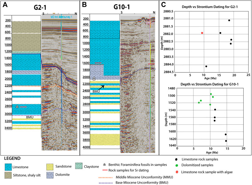
FIGURE 11. (A) Lithological interpretation and snapshot of well-seismic calibration for G2-1 well showing the top of limestone at Cycle V/VI boundary. (B) Core interpretation and snapshot of well-seismic calibration for G10–1 well. Lines location are presented in Figure 1B. (C) Strontium isotope dating for G2-1 and G10–1 core samples (highlighted depth) from Allan et al., 2009. Rock samples from G2-1 (depth 2,881.4 to 2,884.2 m) yield age of 17.0–19.8 Ma while rock samples from G10–1 (depth 1,540 to 1,640 m) gives age between 11.0 to 14.9 Ma. Benthic foraminifera found in the samples are labeled in (A,B), as cross-check for the strontium isotope dating.
The Lower Miocene limestone (Cycle II) form as continuous to sub parallel reflectors often preserving bright amplitude but the thickness is lesser compared to the Middle-Upper Miocene limestone (Figures 7–9). Locally mounded reflector with presence of chaotic features are often found within the Lower Miocene limestone. These seismic characteristics are used to interpret the existence of Lower Miocene limestone in the central part of Central Luconia. Lada Hitam -1 well with total depth of 3,661 m (the deepest well in central section of the study area) reached rock samples of interbedded limestone and sandstone with presence of Florschuetzia levipoli and Cribroperidinium giuseppe at depth 3,174 m (Hulsbos et al., 1991). The presence of these pollen is indicative for Lower Miocene or older age and matches with high amplitude, high frequency wavelets representing the Lower Miocene limestone in Lada Hitam build up (Figure 10A).
The Middle -Upper Miocene (Cycle IV and V) limestone in Central Luconia Province is widely distributed within the central part of the province, while, only streak of Cycle IV and V limestone in shale and silty sediments were found at the south part of Central Luconia. The changes indicate the growth of limestone had stopped earlier in the south of Central Luconia, but massive limestone continued to deposit in the central to north of Central Luconia. The Middle–Upper Miocene limestone build-ups are easily recognized in seismic data as pinnacle or conical shape with limestone stringers on both sides of the flanks. An elongated flat top limestone build-up is also common within Middle–Upper Miocene (Cycle IV and V) (Figure 6). Most of the limestone build-ups in the Central Luconia are connected to each other at the base of the limestone (Cycle III or Cycle IV base carbonate), creating an interconnecting network at the base of the build-ups (Figure 2B). Most of the Middle-Upper Miocene limestone are gently affected by normal faulting, usually at the edge of the build - ups (Figure 6) and act as a migration pathway for the hydrocarbon in the deeper section of the reservoirs.
The strontium age dating for some carbonate build - ups in the central section of Central Luconia Province yield consistent age of Middle -Upper Miocene. As example, strontium age for samples in E8 build-up provides 87Sr/86Sr ratio of 0.78820 that reflect age range of 12.4–16.1 Ma (Allan et al., 2009).
Based on our data, the deep-water section of Sarawak is controlled by faulted blocks with low angle, normal and listric faults that rooted at the boundary of the upper and lower crusts creating the wedge boudinage pattern (Figure 4). The thickness of the crust changes drastically from thin (approximately 3.0–4.0 km) with boudin-shaped in the north to thicker (approximately 5.5–6.0 km) and homogenous pattern in the south. It is observed as crustal necking at the transition of shallow and deep-water section of the study area (Figures 4, 6). Gravitational anomalies in the location of the crustal necking is at the highest value (40- >50 mGal) indicating the shallowest basement level in Central Luconia Province (Figure 1B).
Consistently thick, and elevated crust is observed in the West to Central Luconia Provinces (Figure 5). The depth of the upper crust is interpreted at −5,000 ms from West to Central Luconia and it becomes deeper at −6,000 s underneath F14 well and continuously deepening to -−7,500 s in the eastern side of the West Baram Line (Figure 5). Gravitational anomalies from the free-air satellite indicate average of 25–30 mGal in the west to central part and gravity response increase to 45 mGal in the transition of the West Baram Line (Figure 1B). Thickness of the crust in the south of Central Luconia is inconclusive since our seismic data only able to visualize as deep as the pre-cycle sediments. Based on the gravitational anomalies from free-air satellite gravity, the crustal layers in the south of Central Luconia lies very deep in the subsurface because the gravity anomalies are less than 0 mGal indicating a deep basin (Figure 1B).
The faults in the south of Central Luconia are steeply dipping, shallow rooted with smaller offsets compared to faulting in the north of Central Luconia, similar finding in Jamaludin et al. (2014), Jamaludin et al. (2018). Most of the faults in the south and central parts of Central Luconia only cut through sediments in Cycle I–V (Lower Miocene- Upper Miocene) but locally, younger faults have been observed within the Cycle VI–VIII eastward. The formation of faults within Cycle IV and younger sediments indicate that faulting activity persisted within the post-rift sequence and had no relationship with the crust-involved tectonic events. Almost all Cycle IV–V limestone build-ups were affected by moderate faulting. The faults concentrated at the edges of the limestone build-ups with evidence of potential sub-marine landslide within the limestone build up as presented in Zampetti et al. (2004b). All faults that cut through Cycle IV–V sediments are due to post-depositional faulting and appear to be high-angle normal fault.
Based on G2-1 and G10-1 wells and seismic profiles intersecting with these wells, the base Miocene Unconformity (BMU) and Middle Miocene Unconformity (MMU) in both wells are correlated. The BMU in G2-1 & G10-1 wells (Figure 11A) is indicative of transition from Cycle I to Cycle II, which mark the beginning of base Cycle II limestone in both wells. A major syn-rift fault is interpreted just underneath total depth of Jintan Deep-1 well (Figures 4, 6) and the BMU of Jintan Deep-1 and G2-1 wells are correlated too (Lunt, 2019). The transition of Cycle I to Cycle II sediments in these wells are moderately affected by faults, proving evidence of localized tectonic during Upper Oligocene- Lower Miocene.
The southern part of Luconia-Balingian Provinces evidence contrasting structures as compared to the North and Central Luconia Provinces. A combination of compressional and extensional tectonics defined the southern region of Central Luconia. The seismic profiles show at least three episodes of compression and are describe as Event 1 to Event 3 in this paper. Event 1 indicate the oldest compressional structure possibly dated back to the Upper Cretaceous to Eocene. Folded stratigraphy that formed during Event 1 indicate continuous anticline and syncline structures from the southern part of Central Luconia to the onshore section (Figures 7–9). In our interpretation, the rocks affected by this event are sediments deposited in Pre-Cycle and Cycle I. Based on our data in the southern part of Central Luconia, the anticline and syncline structures are asymmetrical type with gentler limb at one side. The folds are moderately affected by faults and act as the base for younger sediments to deposit. The wavelength from the core of the anticline to another varies from 50 to 70 km.
Anticline structures are also evidenced in the Upper Eocene to Lower Miocene sediments. This is classified as Event 2 (Figures 7–9). Compression in Event 2 affected sediments in Cycle I-III, creating uplifted structures at depth approximately 8–10 km (−4,000 to −5,000 ms in TWT). The folds formed during Event 2 shows different characteristics in the offshore and onshore domain of the study area (Figure 9). In the Balingian Province, the folds are gentler, less asymmetrical with wide-angle limbs compared to the older folds in Pre-Cycle sediments. However, the folds of Event 2 in the onshore section (ie: Tinjar Province) are showing tight angle. Folded strata of Cycle I-III in Event 2 are affected by normal faulting. The normal faults within the limbs and core of the anticlines are rooted into the sedimentary rocks of Pre-Cycle unit. Some of the faults also act as reverse faults. In the onshore section (Tinjar Province) within Engkabang-Karap Anticline (Figure 9), the folded strata of Event 2 were offseted by high angle normal faults on both side of the limbs. The faults are closely spaced at the core and limbs of the anticline. The carbonate development in Engkabang Anticline was initiated on pre-rift faulted and compressed sequence inferred as Middle Eocene (41.0–50.5 Ma), based on biostratigraphy analysis from Shell (1960), published in Jong et al. (2016). The transition from Cycle II (Lower Miocene) to Cycle I (Upper Oligocene) in the sediment is detected by the increase of amplitude preserved in the seismic wavelets corresponding to the top of Cycle I. This abrupt change in seismic facies in Cycle I–Cycle II (Upper Oligocene- Lower Miocene) is believed to represent an important event at 22–23 Ma, marked by the Base Miocene Unconformity (BMU) in this study. This is supported by the finding of nannofossil of NN4 (Baky et al., 1992), indicating age of 17.7 Ma (Raffi et al., 2006) in core sample from Rebab -1 (Figure 10B) as explained in Upper Oligocene- Lower Miocene (Cycle I-II) limestone of this paper. Seismic facies changes between Cycle III limestone and Cycle IV limestone in the southern part of Central Luconia is marked by the Middle Miocene Unconformity (MMU). Cycle III (Lower Middle Miocene) limestone exhibit thin seismic reflections compared to the Cycle IV (Middle Miocene) (Figure 8) which has better acoustic impedance at the top of the cycle. The limestone deposition is more widespread both horizontally and vertically after the MMU.
The southern part of Central Luconia also evidence third episode of compression, marked as Event 3 in this study (Figures 7–9), which is seen in sediments of Cycle V–VIII, dated in Upper Miocene to Pleistocene. Cycle V–VIII sediments are gently folded with evidence of uplifted topography in the onshore section, preserved in Miri. Normal, tight angle, branching faults are commonly seen in Cycle V–VIII. An unconformity is recognized at Cycle V to Cycle VI transition (Upper Miocene to Lower Pliocene) based on changes in seismic facies. This is equivalent to the Lapan Unconformity (LU). LU is traceable in all seismic profiles (Figures 7–9) at the southern section of Central Luconia. However, this unconformity is rarely preserved in the other parts of Luconia Province.
Few seismic profiles in the southern and northern part of the study area exhibit very poor and chaotic seismic reflections throughout Cycle II toward Cycle VI–VIII. It looks like a gas cloud seeping out from the deeper part of the subsurface to the younger rock cycles. This is interpreted as diapiric mobile shale or mobile clay, originated from Cycle I/II mud dominated sediments. The diapiric mobile shale is seen to be sealed under the anticline structures in the southern region of Luconia Province and believed to be originated from Lower Miocene (Cycle II) Setup Shale. The anticline structures trapping diapiric mobile shale (Figure 8) in the near-shore Sarawak is very much alike to the structures seen in Ampa and Seria anticlines in offshore Brunei (Brunei Shell Petroleum, 1996; Darman and Damit, 2003; Morley et al., 2003; Morley et al., 2008). Meanwhile, in the North Luconia Province, the occurrence of mobile shale appears as injected pipe material form into diapiric shapes. The shale diapirs are seen to be originated from the Oligocene–Lower Miocene deposits in Cycle I and II and intruded into the younger sediments in through rifting faults that are common in the northern part of Central Luconia. The mobile shales seen in our data is thought to be similar with shale diapirism induced by gravity-driven system in West Luconia Deltas (Xu et al., 2019) and Bunguran Trough (Jong and Barker, 2014; Jong et al., 2017). Similarly, the over pressure shale is commonly seen as mud volcanoes and mud pools in the onshore of Miri-Tinjar Provinces, including on the surface of Engkabang-Karap anticline (Karap Mud Volcano) (Kessler and Jong., 2016; Kessler and Jong, 2017). The shale diapir is not commonly observed in the central section of Luconia Province, due to the homogenously thick crustal layers in the central part. However, at the boundary of Central Luconia with West Luconia and Tatau Provinces, a seismic profile (Figure 5) shows vertically disrupted chaotic reflections, and these are interpreted as gas clouds The gas clouds cover the limestone build-ups and are trapped within the build-ups.
Regional seismic lines supported by few exploration wells in Luconia Province allow us to evaluate the impact of several tectonic events affecting the area at different timing of limestone growth. Three episodes of limestone growth were detected in Luconia Provinces, each of them representing different tectonic events (Figure 12).
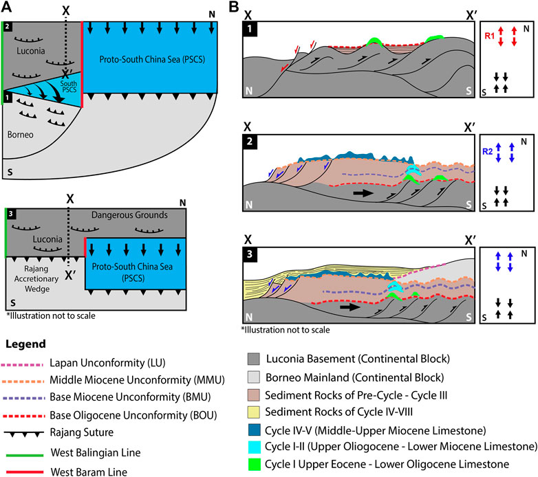
FIGURE 12. (A) Geological model plan view showing the closure of Proto-South China Sea (PSCS) and docking of Luconia continental fragment with Borneo. (B) The cross-sections summarizing the tectonic events and growth of limestone on top of Luconia shelf. Number 1–3 refers to Event 1–Event 3. Event 1: The closure of the southern part of the PSCS (Upper Cretaceous–Eocene) had triggered extensional tectonic from the active rifting of the present day SCS in the north. Event 2: Upper Eocene- Upper Oligocene where extension in the north of Luconia shelf due to second phase of SCS rifting and wrenching tectonic in the south of Luconia. Proto-SCS almost closed and subducted in the norther part. Event 3: Upper Miocene to present day where Borneo underwent regional compression and uplift, inducing gravity driven system that transported the sediment from onshore to offshore, which responsible for the demise of Miocene limestone.
Despite many tectonic reconstructions and opinions on the timing and nature of closure for the Proto- SCS (Holloway, 1982; Tapponnier et al., 1982; Taylor and Hayes, 1983; Tapponnier et al., 1986; Hinz et al., 1989; Hall, 2002), this oceanic crust had a Mesozoic age (Barckhausen and Roeser, 2004; Barckhausen et al., 2015) and the spreading completely stopped by the Middle Miocene (Chang, 2020 and references herein). The southern drift of the Southern China (Luconia and Dangerous Grounds) toward the southern margin is believed to have pushed the oceanic crust of Proto-SCS (Rajang Sea in Sarawak) and finally under thrusted (subducted) beneath West Borneo (Madon, 1999; Hutchison, 2005; Madon et al., 2013; Hennig-Breitfeld et al., 2019) and induced the uplifting of the Rajang Group in the onshore Sarawak (Figure 12A). The Rajang Group was compressed and uncomformably overlain locally with variable ages of sediments from Upper Eocene Tatau Formation to Upper Oligocene Nyalau Formation.
In the present-day offshore section of Sarawak, the uplifted topography of Rajang Group is imaged as anticlinal structures buried in the subsurface (Figure 12B (1)) at depth more than 8 km. The compressional structures from the collision are mostly preserved in the southern part of Central Luconia and Balingian Provinces. The buried anticlinal topography is not seen in the central and north sections of Luconia since the impact of the collision is more preserved landward. Even though no wells penetrate to the top of these anticlines, our moderate to good quality seismic data provide sufficient image of these structures (Figures 7–9). Based on the characteristics of the seismic response on top of these compressional structures, we determined the earliest limestone growth in this province, conceivably grow during the Upper Eocene to Lower Oligocene (Figure 12B (1)). We compared the seismic reflections and pattern in the anticline structures in the south of Central Luconia with Engkabang-Karap Anticline in the onshore (Figure 9) and find similarities in the morphology of the structures. However, the degree of compression is higher in Engkabang-Karap Anticline, compared to the anticlines seen on seismic. This imply the amount of compression is higher in the landward of Sarawak. We suspect the deeply buried limestone that grow on top of these anticline structures are similar to the Engkabang -Karap Limestone based on the oldest age dating (41.0–50.5 Ma based on Shell, 1960) from Engkabang West well (Kessler and Jong, 2016). It is also suspected that the Eocene- Oligocene limestone is equivalent to Melinau limestone outcrop section in Batu Gading, Sarawak that was documented in Adams (1965) and Lunt (2014), which deposited within the Pre- Cycle to Cycle I sediments. Unfortunately, the age and composition of the sediments in Pre-Cycle I and the composition of the crust are poorly known in the offshore. Pre-Cycle I is notably dated from 37 to 43 Ma in Madon et al. (2013) paper, coincides with the rifting of the South China Sea in the north. Apparently, the Pre-Cycle I rocks onshore Sarawak consist of the Belaga, Kelalan and Mulu Formation of the Rajang Group from age 35.4 to 98.0 Ma (Kessler and Jong, 2016).
When the southern part of Luconia including the onshore section was experiencing the compression from the closure of the Proto-SCS and uplifting of the Rajang Group (Figure 12A (1)), it also experienced active rifting in the north, similar to the crustal shortening in Palawan that was induced by the closure of the Proto-SCS at the time where South China Sea is rifting in the North. The effect of the South China Sea rifting had somehow triggered the formation of extensional faults in the crust and is preserved within the lower and upper crusts in the whole southern South China Sea (Fyhn et al., 2013; Franke et al., 2014; Savva et al., 2014; Gozzard et al., 2019), including the North and Central Luconia Provinces as presented in this paper. The lower and upper crust are thinner and elongate with lithospheric mantle tending to exhume into the sediments above the crust (Figure 4). The mantle however does not reach the sedimentary units as observed in the more stretched region in the Phu Khanh, Nam Con Son, Reed Bank, and Dangerous Grounds areas (Fyhn et al., 2009; Cullen et al., 2010; Savva et al., 2013, 2014; Morley, 2016; Wu and Suppe, 2017). Exhumed and exposed mantle materials are suggestive for weak crust in the presence of high heat flow (Li et al., 2014). Although thermal anomalies are seen in the seismic profile (Figure 4), the continental crust of Luconia appears thick enough to escape mantle exhumation in this area compared to the northern region (ie: Vietnam basins). Moreover, the extension factor (Te) in the continent-ocean boundary (near Dangerous Grounds) indicate modern values below 10 km, while in the northern (close to Taiwan), the Te of 13 km (Clift et al., 2002) is recorded, thus reflecting a major asymmetry in the thermal state of the two South China Sea margins with less thermal activities and mantle exhumation in the Dangerous Grounds and Luconia.
By the Upper Eocene to Oligocene, the rifting of the South China Sea had pushed Luconia continental crustal fragment toward the south so that it started to underplate the West Borneo and thus promote compression in the Rajang Accretionary Wedge Group (Hutchison, 2004; Fyhn et al., 2009) that was still forming from the on-going closure of the Proto-SCS (Figure 12A (2)). Albeit the uncertainty in the timing of Luconia shelf underplating with Sarawak mainland, thicker, elevated, faulted and compressed crustal layers are widely observed in the southern part of Luconia to the onshore of Sarawak, particularly in the Tinjar Province. Following this event, base Oligocene Unconformity (BOU) is interpreted. BOU marks the transition from cluster of isolated and elevated grabens in the Eocene to a more widespread sedimentation in Oligocene (Kessler and Jong, 2016). BOU forms as consequence of docking of Luconia continental fragment with Borneo. This is similar to Madon (1999) suggestion that Luconia drifted and collided with West Borneo Basement in the Lower Oligocene (37–32 Ma). The existence uplifted topography from the first compressional event during Eocene were impacted by the second compressional event, creating wrench faulting (Kessler and Jong, 2016) at the core and limbs of the folds in the southern part of Luconia (Balingian and Tinjar Provinces). Limestone dated from the Upper Oligocene -Middle Miocene were found to be deposited at the core of the anticline and spread laterally toward the limb of the folds (Figure 12B (2)). The growth of this limestone indicates the crust was sustained at shallow level for a period from Oligocene to Middle Miocene (Franke et al., 2014), allowing suitable water depth for the carbonate growth.
During this time, the northern part of Luconia crust was already experiencing active rifting, creating lots of listric faults offsetting the sediments that were deposited. Syn-rift faulting are mainly observed in the northern section of the area (Figure 4). The faults rooted deep into the boundary of upper and lower crust, originated from the earlier formed faults during Upper Cretaceous- Eocene when rifting was active in Palawan and surrounding. The deep seated listric faults seen in the northern part of Central Luconia and North Luconia (Figure 12B (2)) are similar to observation made by Pichot et al., (2014), Franke et al. (2014) and Liang et al., (2019) in the other SW sub-basins of the SCS, particularly in the Dangerous Grounds and Nam Con Son Basin. The listric faults exhibit common patterns in the whole SW sub-basins of the SCS, indicating a consistent degree of deformation that affected the whole southern South China Sea. Palawan and the surrounding areas in the north had finally changed the spreading direction from N-S to SW- NE at 23.6 Ma (transition from Upper Oligocene to Lower Miocene), when a ridge jump occurred in the NE sub-basin and opened the SW sub-basin of the South China Sea (Li et al., 2014; Savva et al., 2014; Sibuet et al., 2016). Change in the direction of the South China Sea spreading had affected the sediments in Luconia Province. We marked this as the base Miocene Unconformity (BMU). This imply the Luconia region was receiving the echo from the rifting of the South China Sea in the Reed Bank and Palawan during Lower to Middle Oligocene. Apart from that, the rifting of the SCS is synchronized with the Upper Oligocene warming (Zachos et al., 2001) based on oxygen isotope dating from ODP site 1,148 in the northern part of the South China Sea (Zhao et al., 2001) and Mi-1 glaciation at 23.1 Ma (Miller et al., 1998). This event coincides with change from seasonal to more perhumid climates at the beginning of Lower Miocene (Morley, 2012), suggesting wetter climate than Lower Oligocene (Morley et al., 2020) (end of Event 1 in this paper). This is equivalent to the base of Cycle II deposition in Sarawak and wetter climate facilitated the beginning of limestone expansion in South East Asia including Central Luconia. We are certain on the existence of limestone patches within Upper Oligocene (22–23 Ma) were deposited at least in the southern part of Central Luconia, as evidenced on seismic data (Figures 8, 9). The main expansion of limestone growth in Central Luconia begins at 18–19 Ma (Cycle III) based on the Strontium isotopic dating from limestone samples of G2-1 and G10–1 that indicate Lower Miocene age (Cycle II) (Figure 11) and the fossils found in limestone samples of Rebab-1, A1-1 and Lada Hitam-1 wells (Figure 10). The Lower Miocene limestone then continue to grow as thick pinnacle and platform type carbonate build-ups after Middle Miocene (after 16–17 Ma), following the end of rifting for the South China Sea.
Luconia was a tranquil geological province during Middle -Upper Miocene, owing to the end of rifting in the northern part of Luconia and completion of the collision in the southern part (Figure 12A (3)). The tectonic quiescence was disturbed by a regional compression by the end of Upper Miocene–Pleistocene until recent time affecting the frontal wedge areas especially Sabah and Palawan (Franke et al., 2008; Sapin et al., 2011). This deformation which is believed to have affected the onshore and offshore section of Borneo, including Luconia Province may not be due to important crustal shortening. During this time, West Baram Line had already become inactive-passive fault (ancient fault) (Cullen et al., 2010). The regional uplift in onshore Sabah and Sarawak during Quaternary is observed in the subsurface of Luconia Province as gentle mild folded stratas, affecting only the southern and eastern region of the province (Figure 12B (3)). A more obvious folding due to Quaternary regional uplift is evidenced as Miri Anticline in the onshore of Sarawak. Another observation includes shale tectonics that occurred in the shallower part of Sarawak cycles. The intruded shale is coeval with the recent deformation and is able to mobilize due increase in fluidity related to over pressure (Chang et al., 2019). In the transition from offshore to onshore (Figure 9), the anticline structures seen to be in the older section of Cycle II (Lower Miocene) syncline. There is possibility for the Cycle II anticlines to be swells due to Upper Miocene- Pleistocene compression, that induced the escape of Setap Shale (Cycle I-II sediments) to be injected into younger stratigraphic layers (See Shale Diapir and Gas Cloud above). However, a precaution need to be imposed in interpreting the relation of Lower Miocene syncline swelling due to Event 3, considering the slow velocity of the shale/gas diapir with the surrounding sediments may induced the bow-tie effect that look similar to syncline.
This study explores the architecture of the crust in Luconia Province and evaluate three different records of limestone growth in response to the tectonic activities that affected the Luconia Province since Cretaceous till present day. Interpretation on the kilometer-length seismic profiles illustrated different characteristic of the crustal layers. The northern part of Luconia exhibit thinned, segmented crustal layers that were offset by low angle detachment faults, rooted into top of the ductile lower crust. The changes from thin to thick crustal layers is evidence by the crustal necking at the transition of shallow and deep-water section, with existence of thermal anomalies within the sedimentary units in the northern part of Luconia, indicating weak crust and possible bending of the Moho into the subsurface.
The earliest limestone growth recorded in Sarawak is dated in Upper Eocene, mainly found in the southern Luconia and Balingian Provinces, and preserved mainly in the onshore of Tinjar Province (Engkabang-Karap Anticline). The growth of Upper Eocene limestone is found at the core of anticline and thinly distributed to the limbs of the anticline that resulted from the closure of the Proto South China Sea (Rajang Sea) (Event 1). An attempt to correlate the Upper Eocene-Lower Miocene limestone found in Tinjar Province with offshore section (nearshore) of Luconia-Balingian Provinces is conducted based on the seismic patterns and morphology of the reflectors beneath Rebab-1 well. The second episode of limestone growth is within Upper Oligocene to Lower Miocene, when the subduction of the Rajang Sea underneath mainland Borneo was coming to an end. At the same time, the rifting of the present-day South China Sea is active in the northern margin of Luconia shelf. The Upper Oligocene to Lower Miocene limestone is evidenced as Cycle II-III carbonate rocks that attracted to the elevated anticline structures in the south of Luconia Province and grow as patches of limestone in the central and north part of the province. The third episode of limestone growth in Luconia Province is throughout Middle to Upper Miocene, after the rifting of the South China Sea has ended. The Middle to Upper Miocene limestone grows as pinnacle and flat top build-ups with continuous carbonate layers from Cycle IV to Cycle V. By Lower Pliocene, the whole Borneo underwent regional uplift that resulted in more clastic materials from the onshore to the offshore (gravitational tectonic) and leading to the demise of the limestone growth in Luconia. Finally, this paper highlights the presence of an Upper Eocene- Lower Oligocene limestone on anticlines that demonstrates the occurrence of a major compressional event in the Eocene affecting mostly the southern part of Luconia-Balingian-Tinjar Province. Based on the evidence of successive limestone growth on compressional structure within this region, we show that episodic compressional pulses were affecting the south of Luconia until very recently. Ultimately, from this paper, we show that deformations from the long tectonic episodes experienced by the Luconia Block do not only take place within the wedge of Borneo, but are also recorded offshore of Sarawak, particularly in Luconia Province. The capability of carbonate to flourish in this region in this region in contrasting growth stages at different time will allow further comparison to be done with the other surrounding basins such that in the Dangerous Grounds and offshore of Palawan.
The data analyzed in this study is subject to the following licenses/restrictions: The data belongs to PETRONAS and provided to this study for post-graduate research at Universiti Teknologi PETRONAS. It is confidential and any request to utilize the data shall be directed to Malaysian Petroleum Management (MPM) of PETRONAS. Readers can directly contact the corresponding author at ZmF0aGl5YWguamFtYWx1ZGluQGdtYWlsLmNvbQ== for further information on the data request.
SJ conducted the research by doing the data requisition, data analysis and interpretation. This is guided by BS and MP, along with MB. SJ writes the manuscript. BS and MP edited and improved the manuscript with technical comments. All figures were edited by SJ with discussion with BS and MB. All authors discussed, reviewed and commented on the results and interpretation
The authors declare that the research was conducted in the absence of any commercial or financial relationships that could be construed as a potential conflict of interest.
The authors would like to thank Malaysian Petroleum Management (MPM), PETRONAS for providing the data for this research and their input during the preliminary stage of this work. This study is part of project funded by Universiti Teknologi PETRONAS (UTP) and collaboration between UTP and Ecole Normale Supérieure (ENS). This paper benefited significantly from the feedback of Mr. Peter Lunt, Dr. Georg Warrlich and an anonymous reviewer.
Adams, C. G. (1965). The foraminifera and stratigraphy of the Melinau Limestone, Sarawak, and its importance in Tertiary correlation. Quart. J. Geol. Soc. 121 (1-4), 283–338. doi:10.1144/gsjgs.121.1.0283
Ali, M. Y., and Abolins, P., (1999). “Central Luconia province.” in The Petroleum Geology and resources of Malaysia. (Kuala Lumpur, Petroliam Nasional Berhad (PETRONAS), pp. 369–392.
Allan, T. L., Young, M. D., Korsch, M. J., and Whitford, D. J. (2009). Strontium isotope stratigraphy of Miocene reservoir limestone from the central Luconia province, offshore Sarawak with appendix style by J-B peyaud on paleokarst sediment in the M3-2 well. A report to core laboratories Malaysia on beheld of Sarawak Shell berhad. Australia: CSIRO Division of Petroleum Resources.
Baky, A. A., Bates, C. D., Bon, J., Polhaupessy, A., Richards, F., and Waton, P. V. (1992). Rehab-1 well, block SK-9, offshore Sarawak, Malaysia. AGIP (Malaysia) LTD. Biostratigraphy, paleonvironments and thermal maturity. Singapore: Research. Robertson Singapore PTE. LTD.
Balaguru, A., and Hall, R. (2008). Tectonic evolution and sedimentation of Sabah,North Borneo, Malaysia. AAPG Search and Discovery Article, 30084.
Barckhausen, M. B. W., Boldreel, L. O., and Nielsen, L. H. (2009). Geological development of the central and south Vietnamese margin: implications for the establishment of the south China sea, indochinese escape tectonics and cenozoic volcanism. Tectonophysics 478 (3-4), 184–214. doi:10.1016/j.tecto.2009.08.002
Barckhausen, U., Engels, M., Franke, D., Ladage, S., and Pubellier, M., (2014). Evolution of the South China Sea: revised ages for breakup and seafloor spreading. Mar. Petrol. Geol. 58, 599–611. doi:10.1016/j.marpetgeo.2014.02.022
Barckhausen, U., Engels, M., Franke, D., Ladage, S., and Pubellier, M., (2015). Reply to Chang et al., 2014, Evolution of the South China Sea: revised ages for breakup and seafloor spreading. Mar. Petrol. Geol. 59, 679–681. doi:10.1016/j.marpetgeo.2014.09.002
Barckhausen, U., and Roeser, H. A. (2004). “Seafloor spreading anomalies in the South China Sea revisited.” in Continent-ocean interactions within east asian marginal seas, AGU geophysical monograph, Editors P. Clift, W. Kuhnt, P. Wang, and D. Hayes, Vol. 149 (Washington, DC: American Geophysical Union), 121–125.
Biffi, U., and Calcaterra, P. (1988). Malaysia- block SK 9 well data revision and biostratigraphy (job order: No. 9-MA-GEOL.) A1-1, A2-1/3X, NE Cochrane-1. Kuala Lumpur: AGIP.
Briais, A., Patriat, P., and Tapponnier, P. (1993). Updated interpretation of magnetic anomalies and seafloor spreading stages in the South China Sea: implications for the Tertiary tectonics of Southeast Asia. J. Geophys. Res. 98, 6299–6328. doi:10.1029/92JB02280
Brunei Shell Petroleum. (1996). Clay diapirism and shale-cored push-up ridges in the Geology and hyrdrocarbon resources of negara Brunei Darussalam. Avaliable at: https://www.bsp.com.bn/panagaclub/pnhs_old/geology/HTM/STRUCTUR/ELEMENTS/INTERACT/Inter1_7.html
Chang, S.-P., Jamaludin, S. N. F., Pubellier, M., M. Zainuddin, N., and Choong, C.-M. (2019). Collision, mélange and circular basins in north Borneo: a genetic link?. J. Asian Earth Sci. 181, 103895–103913. doi:10.1016/j.jseaes.2019.103895
Chang, S. P. (2020). Impact of the surrounding subduction zones on the tectonic evolution of the South China Sea (Doctor of Philosophy). Paris, France: PSL Universite Paris, Ecole Normale Superieure.
Clift, P., Lin, J., and Barckhausen, U. (2002). Evidence of low flexural rigidity and low viscosity lower continental crust during continental break-up in the South China Sea. Mar. Petrol. Geol. 19 (8), 951–970. doi:10.1016/s0264-8172(02)00108-3
Cullen, A., Macpherson, C., Taib, N. I., Burton-Johnson, A., Geist, D., Spell, T., et al. (2013). Age and petrology of the usun apau and linau balui volcanics: windows to central borneo's interior. J. Asian Earth Sci. 76 (76), 372–388. doi:10.1016/j.jseaes.2013.05.003
Cullen, A. (2014). Nature and significance of the west Baram and tinjar lines, NW Borneo. Mar. Petrol. Geol. 51, 197–209. doi:10.1016/j.marpetgeo.2013.11.010
Cullen, A., Reemst, P., Henstra, G., Gozzard, S., and Ray, A., (2010). Rifting of the south China sea: new perspectives. Petrol. Geosci. 16 (3), 273–282. doi:10.1144/1354-079309-908
Darman, H., and Damit, A. R. (2003). “Structural control on sediment distribution in offshore bruneo Darussalam, south China Sea.” in Paper presented at the Indonesian Petroleum Association Twenty-Ninth Annual Convention & Exhibition, Jakarta, Indonesia.
Doust, H. (1981). “Geology and exploration history of offshore central Sarawak.” in Volume SG 12: Energy Resources of the Pacific region, (Tulsa, OK: American association Petroleum geologist special), 117–132.
Epting, M. (1980). Sedimentology of Miocene carbonate buildups, central Luconia, offshore Sarawak. Bgsm. 12, 17–30. doi:10.7186/bgsm12198002
Franke, D., Pubellier, M., Steuer, S., Mouly, B., Auxietre, J.-L., Meresse, F., et al. (2014). The final rifting evolution in the South China Sea. Mar. Petrol. Geol. 58, 704–720. doi:10.1016/j.marpetgeo.2013.11.020
Franke, D., Heyde, I., Tingay, M., and Ramli, N. (2008). Seismic images of a collision zone offshore NW Sabah/Borneo. Mar. Petrol. Geol. 25 (7), 606–624. doi:10.1016/j.marpetgeo.2007.11.004
Fyhn, M. B. W., Boldreel, L. O., Nielsen, L. H., Giang, T. C., Nga, L. H., Hong, N. T. M., et al. (2013). Carbonate platform growth and demise offshore Central Vietnam: effects of Early Miocene transgression and subsequent onshore uplift. J. Asian Earth Sci. 76, 152–168. doi:10.1016/j.jseaes.2013.02.023
Gartner, G. L. B., Schlager, W., and Adams, E. (2004). Seismic expression of the boundaries of a Miocene carbonate platform, Sarawak, Malaysia. Tulsa, OK: The American Association of Petroleum Geologists
Gozzard, S., Kusznir, N., Franke, D., Cullen, A., Reemst, P., and Henstra, G. (2019). South China Sea crustal thickness and oceanic lithosphere distribution from satellite gravity inversion. Petrol. Geosci. 25 (1), 112–128. doi:10.1144/petgeo2016-162
Hageman, H., Lesslar, P., and Wong, C. F. (1987). Report No: 03405. Revised biostratigraphy of Oligocene to recent deposits of Sarawak and Sabah. Miri, Sarawak: Petronas Exploration Department.
Hall, R., and Breitfeld, H. T., (2017). Nature and demise of the Proto-South China sea. Bgsm. 63, 61–76. doi:10.7186/bgsm63201703
Hall, R. (2002). Cenozoic geological and plate tectonic evolution of SE Asia and the SW Pacific: computer-based reconstructions, model and animations. J. Asian Earth Sci. 20 (4), 353–431. doi:10.1016/s1367-9120(01)00069-4
Hall, R., van Hattum, M. W., and Spakman, W. (2008). Impact of India–Asia collision on SE Asia: the record in Borneo. Tectonophysics 451 (1–4), 366–389.
Hamdan, N. H., and Jamaludin, S. N. F., (2018). Reservoir characteristics of carbonates build-ups in southern Central Luconia Province: a study based on different scales, Bgsm. 66, 99–105. doi:10.7186/bgsm66201813
Hassan, S. S., and Mohamed, M. (1998). Biostratigraphy study of jintan deep-1 well, block SK 8, Sarawak basin. Kuala Lumpur: Exploration Group, Technical and Consultancy Services Division, Petronas Research and Scientific Sdn. Bhd.
Hennig-Breitfeld, J., Breitfeld, H. T., Hall, R., BouDagher-Fadel, M., and Thirlwall, M. (2019). A new upper paleogene to neogene stratigraphy for Sarawak and labuan in northwestern Borneo: paleogeography of the eastern sundaland margin. Earth Sci. Rev. 190, 1–32. doi:10.1016/j.earscirev.2018.12.006
Hesse, S., Back, S., and Franke, D. (2009). The deep-water fold-and-thrust belt offshore NW Borneo: gravity-driven versus basement-driven shortening. Geol. Soc. Am. Bull. 121 (5-6), 939–953. doi:10.1130/b26411.1
Hinz, K., Fritsch, J., Kempter, E. H. K., Mohammad, A. M., Meyer, J., Mohamed, D., et al. (1989). Thrust tectonics along the north-western continental margin of Sabah/Borneo. Geol. Rundsch., 78 (3), 705–730. doi:10.1007/bf01829317
Ho, K. F. (1978). Stratigraphic framework for oil exploration in Sarawak. Bgsm. 10, 1–13. doi:10.7186/bgsm10197801
Holloway, N. H. (1982). North Palawan block, Philippines:Its relation to Asian mainland and role in evolution of South China Sea. AAPG (Am. Assoc. Pet. Geol.) Bull. 66 (9), 1355–1383.
Hulsbos, R., Poort, R. J., Mohamed, M., and Frame, P. (1991). Lada hitam-1 biostratigraphy of 7 SWC samples of the Lada hitam-1 well block SK-8. Kuala Lumpur, Malaysia: Occidental Petroleum (Malaysia) LTD.
Hutchison, C. (2005). Geology of North-West Borneo: Sarawak, Brunei and Sabah. Amsterdam, Netherlands: Elsevier, pp. 448.
Hutchison, C. S. (2004). Marginal basin evolution: the southern South China Sea. Mar. Petrol. Geol. 21 (9), 1129–1148. doi:10.1016/j.marpetgeo.2004.07.002
Ilao, K. A., Morley, C. K., and Aurelio, M. A. (2018). 3D seismic investigation of the structural and stratigraphic characteristics of the Pagasa Wedge, Southwest Palawan Basin, Philippines, and their tectonic implications. J. Asian Earth Sci. 154, 213–237. doi:10.1016/j.jseaes.2017.12.017
Jamaludin, S. N. F., Pubellier, M., and Menier, D. (2014). Relationship between syn-depositional faulting and carbonate growth in Central Luconia Province, Malaysia. Bgsm. 60, 77–83. doi:10.7186/bgsm60201408
Jamaludin, S. N. F., Pubellier, M., and Menier, D. (2018). Structural restoration of carbonate platform in the southern part of central Luconia, Malaysia. J. Earth Sci. 29 (1), 155–168. doi:10.1007/s12583-017-0812-y
Jong, J., and Barker, S. (2014). “The Sarawak bunguran fold belt: structural development in the context of south China Sea tectonics.” in Paper presented at the International Petroleum Technology Conference, Kuala Lumpur, Malaysia, December 2014.
Jong, J., Barker, S., Kessler, F., and Tran, Q. T. (2017). Basin with multiple sediment sources: tectonic evolution, stratigraphy record and reservoir potential of the Bunguran Trough, south China sea. Berita Sedimentologi. 38, 5–49.
Jong, J., Kessler, F., Noon, S., and Tan, T. Q. (2016). Structural development, deposition model and Petroleum system of paleogene carbonate of the Engkabang-Karap anticline, onshore Sarawak. Berita Sedimentologi. 34, 5–25.
Kessler, F., and Jong, J. (2016). The South China sea sub-basins, regional unconformities and uplift of the peripheral mountain ranges since the Eocene. Berita Sedimentologi. 35, 5–70.
Kessler, F. L., and Jong, J. (2017). Carbonate banks and ramps on the northern shore of Palaeogene and Early Neogene Borneo: observations and implications on stratigraphy and tectonic evolution. Bgsm. 63, 1–26. doi:10.7186/bgsm63201701
Kessler, F. L., and Jong, J. (2015). Tertiary uplift and the Miocene evolution of the NW Borneo shelf margin. Berita Sedimentologi. 33, 21–46.
King, R. C., Tingay, M. R. P., Hillis, R. R., and Morley, C. K. (2010). Present-day stress orientations and tectonic provinces of the NW Borneo collisional margin. J. Geophys. Res. 115 (B10), 1–15. doi:10.1029/2009jb006997
Koša, E. (2013). “Wings, mushrooms and christmas trees: insights from carbonate seismic geomorphology into the evolution of central Luconia.” in Paper presented at the AAPG International Convention and Exhibition, Singapore, September 16–19, 2012.
Koša, E. (2015). Sea-level changes, shoreline journeys, and the seismic stratigraphy of Central Luconia, Miocene-present, offshore Sarawak, NW Borneo. Mar. Petrol. Geol. 59, 35–55. doi:10.1016/j.marpetgeo.2014.07.005
Krebs, W. N. (2011). Upper Tertiary chronosequence stratigraphy of offshore Sabah and Sarawak, NW Borneo, Malaysia: a unified scheme based on graphic correlation. Bgsm. 57, 39–46. doi:10.7186/bgsm201100610.7186/bgsm57201106
Larsen, H. C., Mohn, G., Nirrengarten, M., Sun, Z., Stock, J., Jian, Z., et al. (2018). transition from continental breakup to igneous oceanic crust in the South China Sea. Nat. Geosci. 11 (10), 782–789. doi:10.1038/s41561-018-0198-1
Levell, B. K. (1987). The nature and significance of regional unconformities in the hydrocarbon–bearing neogene sequence offshore west Sabah. Geolog. Soc. Bull. 21, 55–90.
Li, C.-F., Xu, X., Lin, J., Sun, Z., Zhu, J., Yao, Y, et al. (2014). Ages and magnetic structures of the South China Sea constrained by deep tow magnetic surveys and IODP Expedition 349. Geochem. Geophys. Geosyst. 15 (12), 4958–4983. doi:10.1002/2014gc005567
Liang, Y., Delescluse, M., Qiu, Y., Pubellier, M., Chamot‐Rooke, N., Wang, J., et al. (2019). Décollements, detachments, and rafts in the extended crust of dangerous ground, south China sea: the role of inherited contacts. Tectonics, 38 (6), 1863–1883. doi:10.1029/2018tc005418
Lunt, P. (2019). A new view of integrating stratigraphic and tectonic analysis in South China Sea and north Borneo basins. J. Asian Earth Sci. 177, 220–239. doi:10.1016/j.jseaes.2019.03.009
Lunt, P., (2014). A review of the foraminiferal biostratigraphy of the Melinau Limestone, Sarawak. Berita Sedimentology 29, 41–52.
Lunt, P., and Allan, T., (2004). “Larger formarminifera in Indonesia biostratigraphy, calibrated to isotopic dating.” in GRDC Museum Workshop on Micropaleontology, June 2004, 109.
Lunt, P. (2020). Discussion on a new upper paleogene to neogene stratigraphy for Sarawak and labuan in northwestern Borneo: paleogeography of the eastern sundaland margin. Earth Sci. Rev. 202, 102980. doi:10.1016/j.earscirev.2019.102980
Lunt, P., and Madon, M. (2017). Review of the Sarawak cycles: history and modern application. Bull. Geol. Soc. Malays. 63, 77–101. doi:10.7186/bgsm63201704
Madon, M. (1999). “Chapter 19 North Luconia province.” in The Petroleum Geology of Malaysia, (Kuala Lumpur, Malaysia: Petroliam Nasional Berhad).
Madon, M., Kim, C. L., and Wong, R. (2013). The structure and stratigraphy of deepwater Sarawak, Malaysia: implications for tectonic evolution. J. Asian Earth Sci. 76, 312–333. doi:10.1016/j.jseaes.2013.04.040
Mat-Zin, I. (1996). Tertiary tectonics and sedimentation history of the Sarawak basin, east Malaysia (Doctor of Philosophy). Durham, UK: University of Durham. Available at:http://etheses.dur.ac.uk/5198/.
Miller, K. G., Mountain, G. S., Browning, J. V., Kominz, M., Sugarman, P. J., Christie-Blick, N., et al. (1998). Cenozoic global sea level, sequences, and the New Jersey transect: results from coastal plain and continental slope drilling. Rev. Geophys. 36 (4), 569–601. doi:10.1029/98rg01624
Morley, C. K., Back, S., Van Rensbergen, P., Crevello, P., and Lambiase, J. J. (2003). Characteristics of repeated, detached, Miocene-Pliocene tectonic inversion events, in a large delta province on an active margin, Brunei Darussalam, Borneo. J. Struct. Geol. 25 (7), 1147–1169. doi:10.1016/s0191-8141(02)00130-x
Morley, C. K. (2016). Major unconformities/termination of extension events and associated surfaces in the South China Seas: review and implications for tectonic development. J. Asian Earth Sci. 120, 62–86. doi:10.1016/j.jseaes.2016.01.013
Morley, C. K., Tingay, M., Hillis, R., and King, R. (2008). Relationship between structural style, overpressures, and modern stress, Baram Delta Province, northwest Borneo. J. Geophys. Res. 113 (B9), 1–23. doi:10.1029/2007jb005324
Morley, R. J. (2012). “A review of the Cenozoic palaeoclimatic history of Southeast Asia.” in Biotic evolution and environmental change in Southeast Asia, Editors D. J. Gower, K. Johnson, J. Richardson, B. Rosen, L. Rüber, and S. Williams, (Cambridge, UK: Cambridge University Press), 79–114. doi:10.1017/CBO9780511735882.006
Morley, R. J., Hasan, S. S., Morley, H. P., Jais, J. H. M., Mansor, A., Aripin, M. R., et al. (2020). Sequence biostratigraphic framework for the Oligocene to Pliocene of Malaysia: high-frequency depositional cycles driven by polar glaciation. Palaeogeogr. Palaeoclimatol. Palaeoecol. 561, 110058. doi:10.1016/j.palaeo.2020.110058
Pichot, T., Delescluse, M., Chamot-Rooke, N., Pubellier, M., Qiu, Y., Meresse, F., et al. (2014). Crustal structure of the conjugate margins of the SW South China Sea from wide-angle refraction seismic data. Mar. Petrol. Geol. 58, 627–643. doi:10.1016/j.marpetgeo.2013.10.008
Pubellier, M., and Morley, C. K. (2014). The basins of sundaland (SE Asia): evolution and boundary conditions. Mar. Petrol. Geol. 58 (58), 555–578. doi:10.1016/j.marpetgeo.2013.11.019
Raffi, I., Backman, J., Fornaciari, E., Pälike, H., Rio, D., Lourens, L., et al. (2006). A review of calcareous nannofossil astrobiochronology encompassing the past 25 million years. Quat. Sci. Rev. 25 (23-24), 3113–3137. doi:10.1016/j.quascirev.2006.07.007
Sandwell, D. T., and Smith, W. H. F. (1997). Marine gravity anomaly from Ghost and ERS 1 satellite altimetry. J. Geophys. Res. 102 (B5), 10039–10054. doi:10.1029/96jb03223
Sapin, F., Hermawan, I., Pubellier, M., Vigny, C., and Ringenbach, J.-C. (2013). The recent convergence on the NW Borneo Wedge-a crustal-scale gravity gliding evidenced from GPS. Geophys. J. Int. 193 (2), 549–556. doi:10.1093/gji/ggt054
Sapin, F., Pubellier, M., Lahfid, A., Janots, D., Aubourg, C., and Ringenbach, J.-C. (2011). Onshore record of the subduction of a crustal salient: example of the NW Borneo Wedge. Terra. Nova. 23 (4), 232–240. doi:10.1111/j.1365-3121.2011.01004.x
Savva, D., Meresse, F., Pubellier, M., Chamot-Rooke, N., Lavier, L., Po, K. W., et al. (2013). Seismic evidence of hyper-stretched crust and mantle exhumation offshore Vietnam. Tectonophysics 608, 72–83. doi:10.1016/j.tecto.2013.07.010
Savva, D., Pubellier, M., Franke, D., Chamot-Rooke, N., Meresse, F., Steuer, S., et al. (2014). Different expressions of rifting on the South China Sea margins. Mar. Petrol. Geol. 58, 579–598. doi:10.1016/j.marpetgeo.2014.05.023
Shell, (1960). Resume of exploration wells engkabang-1 and -2. Exploration and Petroleum engineering depts. Seria (unpublished report).
Sibuet, J.-C., Yeh, Y.-C., and Lee, C.-S. (2016). Geodynamics of the south China sea. Tectonophysics 692, 98–119. doi:10.1016/j.tecto.2016.02.022
Steuer, S., Franke, D., Meresse, F., Savva, D., Pubellier, M., and Auxietre, J.-L. (2014). Oligocene-Miocene carbonates and their role for constraining the rifting and collision history of the Dangerous Grounds, South China Sea. Mar. Petrol. Geol. 58, 644–657. doi:10.1016/j.marpetgeo.2013.12.010
Tapponnier, P., Peltzer, G., and Armijo, R. (1986). On the mechanics of the collision between India and Asia. Geol. Soc. Spec. Publ. 19 (1), 113–157. doi:10.1144/gsl.sp.1986.019.01.07
Tapponnier, P., Peltzer, G., Le Dain, A. Y., Armijo, R., and Cobbold, P. (1982). Propagating extrusion tectonics in Asia: new insights from simple experiments with plasticine. Geol. 10 (12), 611–616. doi:10.1130/0091-7613(1982)10<611:petian>2.0.co;2
Taylor, B., and Hayes, D. E., (1983). “Origin and history of the south China sea basin.” in The tectonic and geologic evolution of southeast asian seas and islands II, AGU geophysical monograph. Editor D. E. Hayes, (Washington, DC: American Geophysical Union), Vol. 27, 23–56. doi:10.1029/GM027p0023
Ting, K., Chung, E., and Al Ja’aidi, O. (2010). “Evolution and controlling factors of Miocene carbonate build-up in Central Luconia, SE Asia: insights from integration of geological and seismic characterization.” in Integrated Petroleum Engineering and Geosciences (ICIPEG), June 2010, 15, e17. Available at: https://www.researchgate.net/publication/263369354_Evolution_and_controlling_factors_of_Miocene_Carbonate_build-up_in_Central_Luconia_SE_Asia_Insights_from_integration_of_geological_and_seismic_characterization
Ting, K., Pierson, B. J., Al Jaiidi, O., and Hague, P. (2011). “Effects of syn-depositional tectonics on platform geometry and reservoir characters in Miocene carbonate platforms of Central Luconia, Sarawak.” in Paper presented at the International Petroleum Technology Conference, February 12. doi:10.2523/iptc-14247-ms
Vahrenkamp, V. C. (1996). Growth and demise of the Miocene central Luconia carbonate province: implications for regional Geology and reservoir production behavior. PELN-96/135 August 1996. Sabah, Malaysia: Sarawak Shell Berhad and Sabah Shell Petroleum Co. Limited.
Vahrenkamp, V. C., (2004). “Growth architecture, faulting , and karstification of a middle Miocene carbonate platform, Luconia province, offshore Sarawak, Malaysia.” in Seismic imaging of carbonate reservoirs and systems, (Tulsa, OK: AAPG Memoir) 81, 329–350.
Vahrenkamp, V. C. (1998). Miocene carbonates of the Luconia province, offshore Sarawak: implications for regional geology and reservoir properties from strontium-isotope stratigraphy. Bgsm. 42, 1–13. doi:10.7186/bgsm42199801
Van Hoorn, B. (1977). Stratigraphy, tectonics and hydrocarbon habitat. Sabah Shell Pet. Co. Ltd. Exp.
Wu, J., and Suppe, J. (2017). Proto-South China sea plate tectonics using subducted slab constraints from tomography. J. Earth Sci. 29 (6), 1304–1318. doi:10.1007/s12583-017-0813-x
Xu, J., Ren, J., and Luo, P. (2019). The evolution of a gravity-driven system accompanied by diapirism under the control of the prograding West Luconia deltas in the kangxi depression, southern South China sea. Mar. Geophys. Res. 40 (2), 199–221. doi:10.1007/s11001-019-09384-8
Zachos, J., Pagani, M., Sloan, L., Thomas, E., and Billups, K. (2001). Trends, rhythms, and aberrations in global climate 65 Ma to present. Science 292 (5517), 686–693. doi:10.1126/science.1059412
Zampetti, V., Schlager, W., van Konijnenburg, J.-H., and Everts, A.-J. (2004b). 3-D seismic characterization of submarine landslides on a Miocene carbonate platform (Luconia Province, Malaysia). J. Sediment. Res. 74 (6), 817–830. doi:10.1306/040604740817
Zampetti, V., Schlager, W., van Konijnenburg, J.-H., Everts, A.-J., and Everts, A-J. (2004a). Architecture and growth history of a Miocene carbonate platform from 3D seismic reflection data; Luconia province, offshore Sarawak, Malaysia. Mar. Petrol. Geol. 21 (5), 517–534. doi:10.1016/j.marpetgeo.2004.01.006
Keywords: luconia province, south China sea, limestone growth, extensional tectonic, compressional tectonic
Citation: Jamaludin SNF, Sautter B, Pubellier M and Beg MA (2021) The Succession of Upper Eocene- Upper Miocene Limestone Growth and Corresponding Tectonic Events in Luconia Shelf, Sarawak, Malaysia. Front. Earth Sci. 9:588629. doi: 10.3389/feart.2021.588629
Received: 29 July 2020; Accepted: 27 January 2021;
Published: 25 February 2021.
Edited by:
Basilios Tsikouras, Universiti Brunei Darussalam, BruneiReviewed by:
Peter Clift, Louisiana State University, United StatesCopyright © 2021 Jamaludin, Sautter, Pubellier and Beg. This is an open-access article distributed under the terms of the Creative Commons Attribution License (CC BY). The use, distribution or reproduction in other forums is permitted, provided the original author(s) and the copyright owner(s) are credited and that the original publication in this journal is cited, in accordance with accepted academic practice. No use, distribution or reproduction is permitted which does not comply with these terms.
*Correspondence: Siti Nur Fathiyah Jamaludin; ZmF0aGl5YWguamFtYWx1ZGluQHV0cC5lZHUubXk=; ZmF0aGl5YWguamFtYWx1ZGluQGdtYWlsLmNvbQ==
Disclaimer: All claims expressed in this article are solely those of the authors and do not necessarily represent those of their affiliated organizations, or those of the publisher, the editors and the reviewers. Any product that may be evaluated in this article or claim that may be made by its manufacturer is not guaranteed or endorsed by the publisher.
Research integrity at Frontiers
Learn more about the work of our research integrity team to safeguard the quality of each article we publish.