 Stefania C. Oliveira
 Fabiano N. Pupim
 José C. Stevaux
 Mario L. Assine
- 1Institute of Geosciences and Exact Sciences, São Paulo State University, Rio Claro, Brazil
- 2Institute of Environmental, Chemical and Pharmaceutical Sciences, Federal University of São Paulo, Diadema, Brazil
- 3Federal University of Mato Grosso do Sul, Três Lagoas, Brazil
The Paraná River has been extensively studied in terms of hydrological and sedimentological characterization. However, the geological history of its fluvial plain is poorly understood due the lack of geochronological data. Most of the studies are focused in the low and middle reaches, whereas the region upstream of the Porto Primavera dam is an almost unknown area in terms of geomorphic evolution. Thus, the main aim of this study was to investigate the succession of geological events responsible for the evolution and current configuration of the fluvial system of the Upper Paraná River, between the Jupiá and Porto Primavera Hydroelectric Power Plants (São Paulo and Mato Grosso do Sul states). In order to achieve this goal, we used an integrated approach including remote sensing data, geomorphology, sedimentology, geochronology and bathymetric profiles. Four geomorphological compartments were identified and three of these compartments were dated by Optically Stimulated Luminescence (OSL): Unit 1, raised terrace with circular and semicircular ponds (∼150 ka); Unit 2, intermediate terrace with small ponds and waterlogged areas (∼60 ka); Unit 3, low terrace with preserved paleochannels (∼39–35 ka); and Unit 4, current river plain (>9 ka). The geomorphological units were correlated with previous studies downstream of the studied area and their sedimentary characteristics and depositional ages suggest that their genesis is linked to changes in climatic and hydrological conditions during the Late Quaternary. Units 1, 3 and 4 are considered extensions of the geomorphological units Taquaruçu, Fazenda Boa Vista and Rio Paraná, respectively. Unit 2 is a compartment with unique morphological characteristics, therefore not correlated with units presented in previous works. Further, two main knickpoints were identified, suggesting an important control in the sedimentation and development of the terrace levels. Therefore, this work brings new data about the fluvial plain of the upper reach of the Paraná River, that allows to interpret that the development of terrace levels and floodplain are strongly controlled by climate changes occurred during the Late Quaternary.
Introduction
The Quaternary period is characterized by large amplitude cyclic climatic variations (glacial-interglacial) that produced significant environmental changes in vegetation, sediment production and fluvial regime (Vandenberghe, 1995). To elaborate geomorphological models that help us understand the origin and evolution of the Brazilian landscapes we need to characterize and map geomorphic features and comprehend morphogenetic processes to define the sequence of events that molded the landscape. The sedimentary deposits of fluvial plains record the processes and the environmental changes through the geomorphological evolution of drainage basins (Pazzaglia, 2013). Geomorphological and sedimentological studies combined with absolute datings (e.g., C-14 dating or optically stimulated luminescence – OSL) make possible to use fluvial plains deposits as stratigraphic markers for interpretation and correlations of regional environmental changes (Bridgland and Westaway, 2008).
Knowledge of the Quaternary evolution of Brazilian rivers is still in its infancy. Most of the available information refers to the Amazonian rivers, while very little is known about central and southern Brazilian rivers. Among them stands out the Paraná River, the second largest river in South America with a drainage basin of 2.6 million km2 (including its main tributary, the Paraguay River). The Paraná River is one of the ten largest rivers on the planet, with an annual average discharge of 18,000 m3/s and about 200 × 106 tons of sediment load transported per year (Orfeo and Stevaux, 2002; Latrubesse et al., 2005). The Paraná River is named after the confluence of the Grande and Paranaíba Rivers on the border of the states of São Paulo, Minas Gerais and Mato Grosso do Sul, and its mouth is far away in the La Plata Estuary on the border between Uruguay and Argentina. The river is divided into upper (Brazil), medium (From Sete Quedas Falls to the mouth of the Paraguay River, lower (from the mouth of the Paraguay to Rosário, Argentina) and tide influenced (from there to its mouth at La Plata Estuary) courses based on distinct geomorphological and hydrological characteristics (Figure 1).
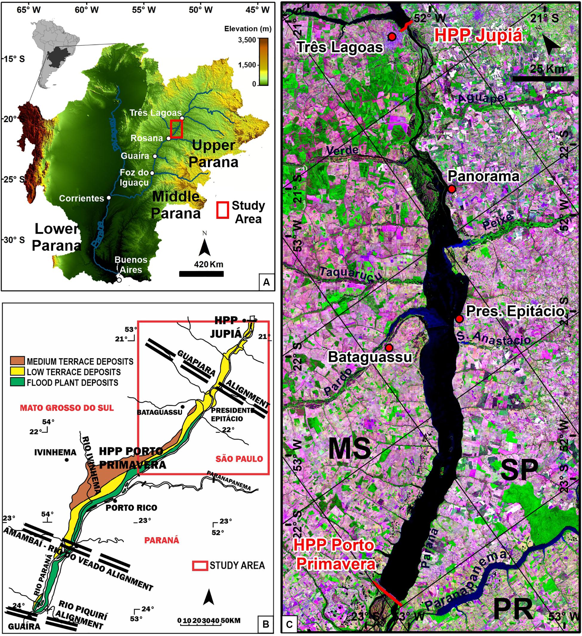
Figure 1. Location of the Upper Paraná River. (A) The Paraná River Watershed and studied area in the upper stretch (red square). The Paraná River is divided into upper, medium, lower and tide influenced courses based on distinct geomorphological and hydrological characteristics; (B) Area between the Jupiá dam and Guaíra and deposits associated with the river channel of the Upper Paraná River, defined by geological control (modified by Souza Filho and Stevaux, 1997); (C) Study area is between the Jupiá and Porto Primavera Hydroelectric Power Plants – São Paulo and Mato Grosso do Sul states, Brazil (Landsat 8 image, composition 6R5G4B, 2016).
The Upper Paraná River is entirely in Brazilian territory, extending from the confluence of the Grande and Paranaíba rivers to the beginning of the reservoir of the Itaipu Hydroelectric Dam, border between Brazil and Paraguay (Stevaux, 1994). An expressive knickpoint of 210 m (the former Sete Quedas Falls) delimits the upper and middle reaches of the river. The climate is tropical-subtropical humid with dry winter season. The current knowledge about the geomorphological evolution of the Upper Paraná fluvial plain is based exclusively in the reach downstream of the Porto Primavera Hydroelectric Dam (e.g., Stevaux, 1994, 2000; Santos and Stevaux, 2000; Stevaux and Souza, 2004; Parolin et al., 2006, 2007; Guerreiro et al., 2013; Leli et al., 2017).
Information from the fluvial plain upstream of the Porto Primavera Dam is still scarce but can contribute significantly to the understand of the Quaternary evolution of the rivers in the Upper Paraná drainage basin. In this context, we investigated a 288-km-long fluvial reach between the Porto Primavera and Jupiá dams, two-thirds of which is now covered by the Porto Primavera reservoir (Figure 1). We used remote sensing data, topographic surveyed previously to the reservoir begins to fill with water, sedimentary descriptions and OSL dating to identify and characterize fluvial deposits that forms terrace levels and fluvial plain. These deposits were compared and correlated with those described downstream of the Porto Primavera Dam, in order to perform a regional dataset for better understand the geologic events occurred in the Upper Paraná River basin from the Pleistocene to Holocene.
Geomorphology of the Upper Paraná River
The Upper Paraná is a mixed alluvial-over rock river running over Mesozoic basaltic rocks of the Serra Geral Formation (São Bento Group), sedimentary rocks of the Caiuá Group, and over 10 to 25 m of alluvial sediments. Several sedimentary terrace levels were formed during Quaternary landscape denudation and Paraná River downcutting.
Stevaux (1994) identified four geomorphological units in the area of Porto Rico village located downstream of the Porto Primavera Dam (Figure 1). The Porto Rico unit encompass colluvial deposits that occur on flat hills in the highest elevation above 280 m, in both margins and with subtle dip toward the Paraná River, it corresponds to a regional planation surface. The Taquaruçu unit is composed of colluvium-alluvium deposits and occurs mainly in the right margin of the river as a fluvial terrace with flat top dipping from 280 to 245 m, characterized by the presence of hundreds of circular to elliptical and irregular pans and lakes ranging from 500 to 6,000 m in diameter.
The Boa Vista unit is a fluvial terrace elevated between 232 and 245 m. Its surface is characterized by braided-like paleochannels formed during the late Pleistocene (∼40 ka; Stevaux, 2000) and remains of source-bordering dunes formed in the late-mid Holocene (Parolin and Stevaux, 2001). The deposits of the Paraná River unit are related to the modern fluvial plain, which shows an anabraching river positioned 8 to 10 m lower that the Boa Vista unit.
The units described for Porto Rico area were in attempt extended to studied area by Souza Filho and Stevaux (1997), who recognized the occurrence of the units Taquaruçu, Fazenda Boa Vista and Paraná River units upstream of the Porto Primavera Dam.
According Stevaux (2000), the fluvial deposits of the Paraná River record paleoclimatic events in the Upper Paraná drainage basin. From the Late Pleistocene to the beginning of the Holocene, the fluvial plain developed under dry climatic conditions (40 to 8 ka). Wetter conditions prevailed during the middle and upper Holocene, except for a short period of aridity from 3.5 to 1.5 ka.
The Quaternary lithostratigraphic units were grouped in the Upper Paraná River Allogroup, constituted by the Paranavaí and Paraná Alloformation (Sallun et al., 2007). The Paranavaí Alloformation is relatively older, composed of sandy deposits formed by colluvial processes with intense weathering transformation, and corresponds to the Porto Rico geomorphological unit from Stevaux (1994). The Paraná Alloformation is the youngest, comprising all fluvial deposits related to the Taquaruçu, Fazenda Boa Vista and Rio Paraná geomorphological units from Stevaux (1994). The precise chronology of these deposits is still under debated, once only a few studies had used radiometric techniques to date them. Stevaux (1994, 2000), Parolin et al. (2006, 2007), Guerreiro et al. (2013), Leli et al. (2017), using 14C, TL and OSL ages, estimated depositional ages from 150 ka to present for the formation of the fluvial and aeolian sediments that comprises Paraná Alloformation in the reach of the Paraná river downstream of the Porto Primavera Hydroelectric Dam. Sallun and Suguio (2007) applied Thermoluminescence (TL) and OSL methods to dating deposits from Paranavaí and Paraná Alloformations, in which the reported results show scattered ages from 6 to 980 ka for the Paranavaí Alloformation and 14 to 240 ka for the Paraná Alloformation. However, these chronological framework should be interpreted with caution, because OSL ages were estimated using multiple-aliquot protocol that can produce bias due its inability to normalize the heterogeneity of sensitization in quartz grains from a natural sample (Jain et al., 2003); further, several ages are above the common upper age limit (150–200 ka), which is controlled by dose saturation in quartz grains (Rhodes, 2011).
Materials and Methods
Geomorphological Mapping
The geomorphological mapping was based on remote sensing image interpretation (Landsat System) and SRTM(Shuttle Radar Topographic Mission) altimetry data, obtained from the website http://glovis.usgs.gov, United States Geological Survey (USGS). The geographic database was organized on the Geographic Information System software ArcGis 10.1, and Google Earth was used to verify and detail mapping of the geomorphologic forms observed on the Landsat and SRTM images.
Landsat 5 TM images from 1985, before the construction of the Porto Primavera dam, were utilized to identify geomorphological forms and compartments that are nowadays submerged by the Porto Primavera reservoir. Landsat 8 OLI/TIRS images from 2016 were used to evaluate changes, deduce processes and identify geomorphological features. The scenes used from the Landsat system were: 224/74, 224/75, 224/76, 222/74, 222/75, 222/76, 223/74, 223/75, and 223/76. Digital processing of the images was conducted to enhance geomorphologic features of interest, especially compositions 5R4G3B and 6R5G4B for images from 1985 and 2016, respectively.
SRTM/C data used on this work has resolution of 3 arc seconds (90 m) and vertical precision of ±9 m, and were processed in the Global Mapper 15 software, in the attempt to highlight geomorphological features of interest. The topographic levels were highlighted by reclassification of the color palette (Merino et al., 2015) and the altimetric intervals adopted were used in the creation of the digital elevation model (DEM), morphometric analysis and construction of topographic profiles. Besides topographic profiles elaborated from SRTM data, topobathymetric profiles were created using bathymetric data from the Companhia Energética de São Paulo (Cia Energética de São Paulo [CESP], 1997). The original data comprises 21 bathymetric cross profiles that allow us to identify geomorphic features that were submerged by the filling of the reservoir of the Porto Primavera dam in 1998.
The geomorphological zonation was carried out from the visual interpretation of remote sensing images, guided by the procedures described in Soares and Fiori (1976) and Veneziani and Anjos (1982). This procedure allowed the characterization and delimitation of zones of similar morphological elements integrated to the altimetric data, later interpreted as geomorphological units. The classification for the geomorphological units was established based on their genetic characteristics. The geomorphic mapping was performed by visual recognition of the landforms and geomorphological units, directly on the computer screen, using three main criteria: (1) delimitation of the fluvial plain and Paraná river terraces, based on morphological relationships recognized in satellite images and SRTM data; (2) recognition of zones of similar landforms and definition of geomorphological units, from similar textural features of satellite images; (3) identification of the different topographic levels of terraces, inserted in previously delimited geomorphological units. The terraces were delimited from their morphological characteristics: parallel in relation to the fluvial course, and flat and steep levels. Thus, terraces located closer to the river channel and at lower topographic levels should have more recent ages, while terraces located in the furthest portions of the channel and at higher topographic levels tend to be older.
Two field trips were carried out to verifying the interpretation of remote sensing products, geomorphological characterization, recognition of altimetric levels and to describe the sedimentary deposits. In addition, sites were selected for sediment sampling for OSL dating.
The altimetric data of the topobathymetric profiles elaborated by Cia Energética de São Paulo [CESP] (1997) and the altimetric data acquired from SRTM-DEM were also used for the elaboration of a comparative table with longitudinal profiles of the Paraná river (from the surface of the water in the normal flow stage and the bottom of the channel) and levels of terraces found in the studied section.
Dating by Optically Stimulated Luminescence (OSL)
The sampling for OSL dating followed the guidelines defined by Nelson et al. (2015). The sediments were collected with opaque PVC tubes to avoid exposure to sunlight. OSL measurements were carried out in the Gamma and Luminescence Spectrometry Laboratory of the Institute of Geosciences, University of São Paulo, Brazil (LEGaL-USP).
Preparation of the samples for determination of the equivalent dose (De) was performed in a room illuminated by lamps that emit orange light wavelength to preserve the natural luminescence signal. The procedures for sample preparation consist of: sieve and separation of fraction 180–250 μm, H2O2 attack (27%) for elimination of organic matter; HCl attack (10%) to remove carbonates; HF attack (40%) for 40 min, to eliminate feldspar and the external surface of the quartz grains and to remove the external surface of the quartz grains affected by alpha radiation; densitometric separation with lithium metatungstate (LMT), to remove heavy minerals (>2.75 g/cm3) and feldspar grains (<2.62 g/cm3). Thus, quartz grain concentrates were obtained for each sample. To determine the De of each sample, 24 aliquots of the quartz concentrate, load on 1 cm diameter aluminum discs, were used following the single aliquot regenerative-dose protocol (SAR) of Murray and Wintle (2000; 2003; Table 1). The OSL/SAR analyzes were carried out on a Risø automatic system (Risø National Laboratory).
Table 1. SAR-OSL protocol used for equivalent dose estimation of the studied samples, according to Murray and Wintle (2000, 2003).
Tests were performed to measure the quartz luminescence signal and to verify if the parameters used in the SAR protocol are adequate. The tests carried out were: (1) Dose recovery test, where the difference between the laboratory dose applied and estimated dose using the SAR protocol should not exceed 10%; (2) Recycling ratio test, since changes in the sensitivity of quartz due to irradiation cycles may occur during OSL measurements. Thus, the aliquots must have values between 0.9 and 1.1; (3) Presence of feldspar to verify absence of feldspar at all aliquots; and (4) Recuperation test, in which corrected zero dose should be less than 5% of the corrected natural signal (Murray and Wintle, 2003). Only the aliquots approved in the tests were used to estimate De, where the Central Age Model (CAM) was used to construct a representative burial dose for each sample (Galbraith et al., 1999).
The concentration of radionuclides for the calculation of the environmental dose rate was determined by gamma spectrometry using a high purity germanium detector (HPGe, 55% relative efficiency and 2.1 keV resolution) in ultra-light background screening (Canberra Industries). The samples were dried and packed in sealed plastic containers and stored for at least 28 days to reestablish the balance between Radon and elements of its decay chain. The dose rate from beta and gamma radiation was determined from the concentration of U, Th, and K radionuclides and conversion factors presented by Guérin et al. (2011). Water saturation was estimated from the relation between water weight and dry sample weight. The evaluation of cosmic rays dose rate was calculated from the information of latitude, longitude, altitude, depth, and density of each of the samples, as described by Prescott and Hutton (1994).
Results
Geomorphological Units
Satellite images obtained before the Porto Primavera reservoir was filled with water revealed that in the study area the Paraná River had very low sinuosity tending to be straight downstream, with the channel on the left side of the fluvial valley, while most of the fluvial plain developed in the right margin of the river. The geomorphological analysis allowed identification and characterization of four geomorphic units placed in different topographic levels and with distinct morphologic characteristics: (1) elevated terrace with circular and semi-circular ponds; (2) intermediate terrace with small ponds and wetlands; (3) low terrace with preserved paleochannels; and (4) current fluvial plain (Figure 2 and Table 2).
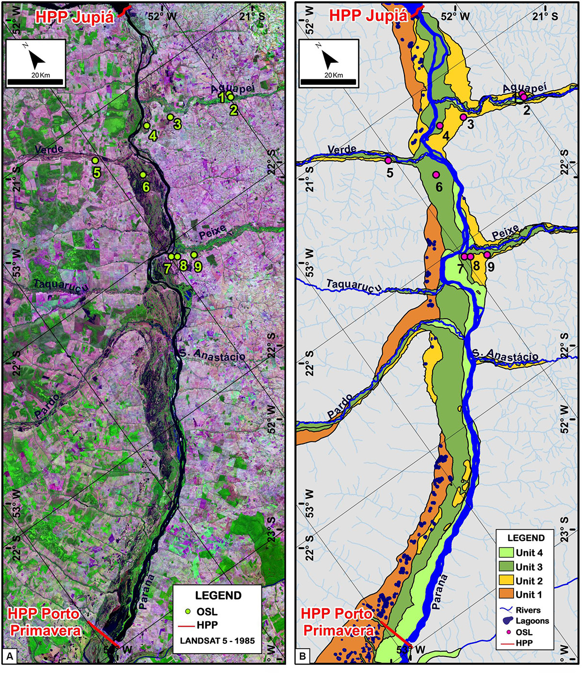
Figure 2. Geomorphology of the Upper Paraná River. (A) Landsat image, composition 5R4G3B, 1985 (before the dam). (B) Geomorphological zones of the fluvial plain and terraces of the study area.
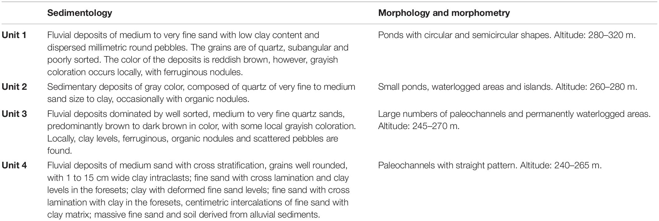
Table 2. Main sedimentological, morphological and morphometric characteristics corresponding to the different geomorphological units.
Unit 1
Unit 1 comprises high terraces marked by the presence of ponds. The altitude varies between 280 m from the dam of Porto Primavera up to 320 m in the region of Três Lagoas, MS, being the highest unit among the four identified, and therefore the oldest. This unit occurs predominantly on the right side of the fluvial plain, between 0.5 and 13 km from the Paraná river bank (Figure 2). The main exposition of the representative deposits of this unit occurs on the right bank of the Paraná River, in the stretch between the mouths of the Verde and Taquaruçu rivers (Figure 3). In this section, a strong 90° inflection turns the main channel to the right side of the plain for about 10 km, carving an escarpment up to 50 m in height called “Paredão das Araras” (Figure 4A).
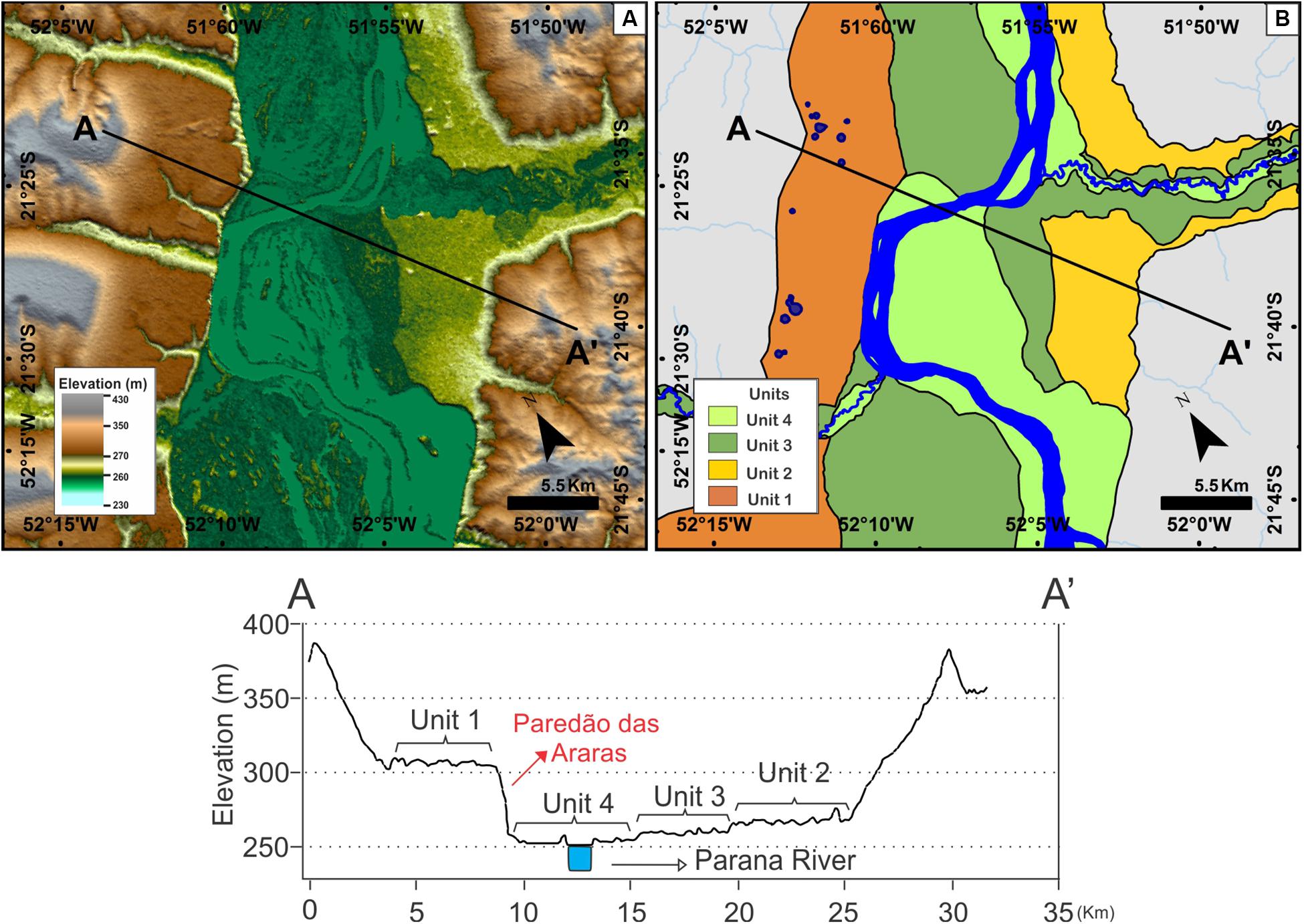
Figure 3. Representative terrace levels and fluvial plain mapped in the Upper Paraná River. (A) Digital Elevation Model (DEM) elaborated from SRTM data; (B) Geomorphologic units: Unit 1 in brown, Unit 2 in yellow, Unit 3 in dark green and Unit 4 in light green. Topographic profile below A-A′, with altimetric levels of approximately 300 m for Unit 1, 270 m for Unit 2, 260 m for Unit 3, and 250 m for Unit 4.
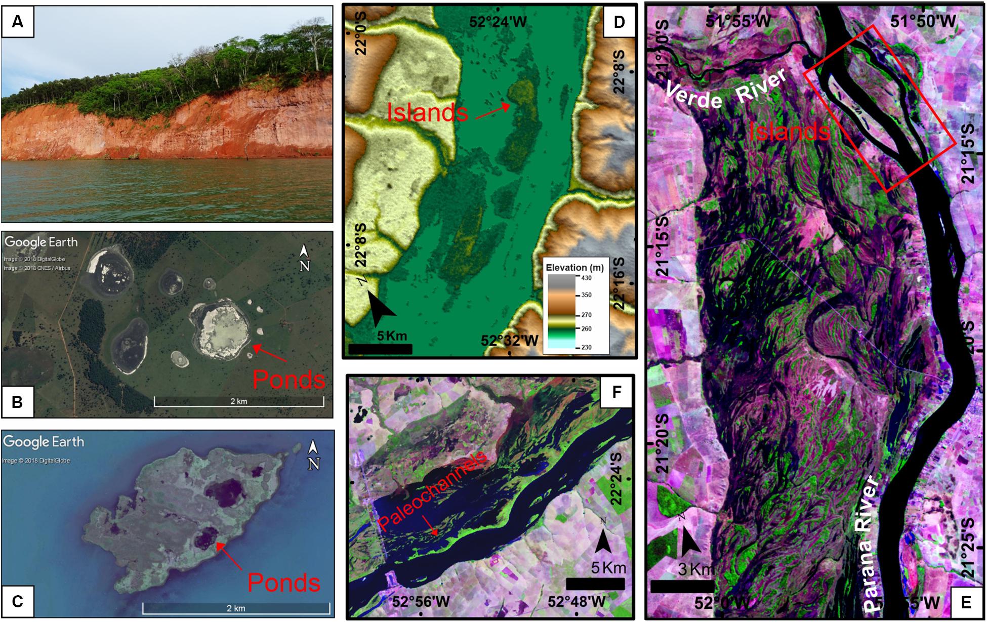
Figure 4. Characteristic features of the geomorphologic units in this work. (A) Photo of the Paredão das Araras, located in the right margin of the Paraná River (Mato Grosso do Sul) between the Verde and Pardo rivers. It is a sandstone escarpment varying between 10 and 30 m in height. (B) Circular shaped ponds found in Unit 1 located ∼60 km upstream of Porto Primavera HPP (image acquired through Google EarthTM DigitalGlobe, 2018 and CNES/Airbus, 2018). (C) Unit 2 identified in some islands located around 52 km upstream of the Porto Primavera dam. The ponds found in Unit 2 and within the islands are different from those found in units 1 and 3, being smaller and irregular (image acquired through Google EarthTM, DigitalGlobe, 2018). (D) The islands of Unit 2 (dark green) are highlighted by the DEM. The islands are in a higher topographic position than Unit 4 (light green) and lower than Unit 1 (yellow). (E) Private Reserve of Natural Heritage (PRNH) Fazenda Cisalpina (CESP) located in Unit 3. It contains preserved geomorphological features such as paleobars and lagoons clearly associated to paleochannels with morphologies and dimensions distinct from those exhibited by the present-day channel. Highlighted in red are islands that are partially flooded. (Landsat 5 image – 1985, composition 5R4G3B). (F) More rectilinear paleochannels are observed close to the Porto Primavera HPP, parallel to the main channel, characteristic of Unit 4 (Landsat 5 image – 1985, composition 5R4G3B).
Currently, due the dam of the Porto Primavera Hydroelectric Power Plant, the waters of the Paraná River covered up part of Unit 2 and placed Unit 1 closer to the riverbanks, excluding the area near Três Lagoas, where it is adjacent to Unit 2 (Figure 3). The topographic unevenness between Units 1 and 2 is of approximately 20 m, very expressive when highlighted in DEM and clearly visible in topographic profiles (Figure 3). The main characteristic of this unit is the presence of ponds with circular and semicircular shapes, with diameters varying from 50 to 1000 m, isolated and interconnected (Figure 4B).
Unit 2
Unit 2 represents an intermediate terrace with small ponds and waterlogged areas (Figures 3, 4C). This unit is present in altitudes around 260 to 280 m and its width varies from 1 km up to 10 km near the mouth of the tributaries Aguapeí and Peixe (Figures 2, 3). In the analyzed images and topobathymetric profiles from Cia Energética de São Paulo [CESP] (1997) it was possible to recognize this unit in some islands located approximately 52 km upstream of the Porto Primavera dam (Figure 4D). These islands are in a higher topographic position than Unit 4 (fluvial plain) and Unit 3 (low terrace), but it is in a lower topographical level than Unit 1. Another characteristic of this unit are the ponds found on the banks of the Paraná River or within islands (Figure 4C). These ponds are different from those found in Units 1 and 3, being smaller and irregular.
Unit 3
Unit 3 represents the level of the low terraces of the Paraná River, marked by large numbers of paleochannels and permanently waterlogged areas (Figure 4E). The width varies from 1 to 12 km and the altitude between 245 and 270 m, being topographically higher in the northern portions of the studied area. It is 5 to 10 m higher than modern floodplain (Unit 4) (Figure 3). This unit presents preserved geomorphological features, characteristic of a river with a multichannel pattern, such as paleobars and small lakes clearly associated with paleochannels, which dimensions and morphologies different from those shown by the current channel (Figure 4E). Due to these preserved paleochannels, the morphology of Unit 2 presents undulations on its surface, with marginal dikes remaining free from flooding for longer periods and with herbaceous and arboreal vegetation. The paleochannels located downstream of the mouth of the Verde River are partially flooded due to the elevation of the hydrometric level of the Paraná river in the reservoir of the Porto Primavera Hydroelectric Power Plant. The elevation of the hydrometric level of the Paraná River also affected the islands of Unit 3, observed in the field to be partially flooded (Figure 4E).
Unit 4
Unit 4 consists of the most recent fluvial plain of the Paraná River, which is 0.1 to 8 km wide; however, it is currently submerged in a large part of the area due to the Porto Primavera dam (Figure 2). From upstream to downstream, this unit varies between altimetric heights of 265 to 240 m (Figure 3). It has a narrow, elongated geometry parallel to the active channel, with a local relief between 1 and 2 m (Figure 2). It is possible to observe in Landsat-5 images from 1985 that this unit had lowland and riparian vegetation. The main characteristics of Unit 4 are paleochannels with straight pattern than those observed in Unit 3, and elongate bars and ponds, similar to the current channel pattern (Figure 4F).
Geochronology of the Fluvial Deposits
Optically Stimulated Luminescence/Single aliquot regenerative-dose protocol dating of 12 samples indicate ages between 60,5 ± 6,1 ka and 0,7 ± 0,1 ka for fluvial deposits of the Upper Paraná River and its tributaries, Aguapeí, Peixe and Verde rivers. The locations of the sampling points are shown in Figure 2 and data regarding the OSL ages, equivalent doses and dose rates can be seen in Table 3 and Supplementary Table S1, respectively.
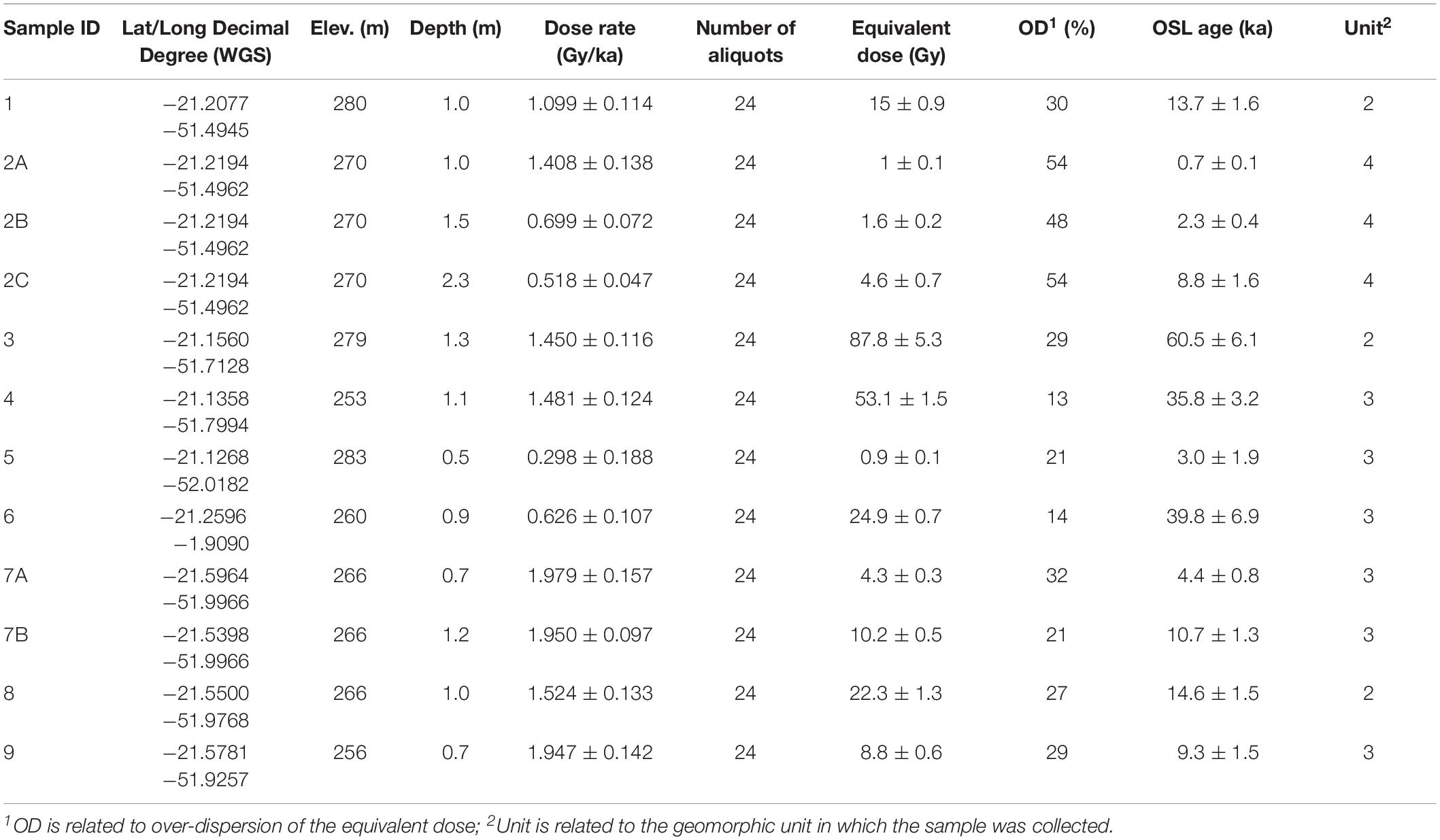
Table 3. Data summary of the OSL dating: equivalent doses, dose rates and ages.
Three samples were collected In Unit 2 at the points: 1, 3 and 8, where the respective ages were 13.7 ± 1.6, 60.5 ± 6.1 and 14.6 ± 1.5 ka. Fine sand and clay sediments were collected at approximately 1 m depth. For Unit 3, six samples corresponding to the points: 4, 5, 6, 7 (A and B) and 9 were analyzed. The deposition interval of the fine sand and clay sediments occurs at approximately 1 m depth and presented a maximum age of 39.8 ± 6.9 ka (point 6) and minimum age of 3.0 ± 1.9 ka (point 5). In the fluvial deposits of Unit 4, three samples (A–C) were dated in point 2. The predominantly sandy deposits, collected in the Aguapeí River at depths of 1, 1.55 and 2.3 m, are 0.7 ± 0.1, 2.3 ± 0.4, and 8.8 ± 1.6 ka respectively.
Sedimentology
The sedimentary deposits corresponding to the different geomorphological units were described according to their sedimentological characteristics (Table 2). Thus, in Unit 1 deposits of medium to very fine sand with low clay content and dispersed millimetric round pebbles were found predominantly. The grains are of quartz, subangular and poorly sorted. The color of the deposits is reddish brown, however, grayish coloration occurs locally, with ferruginous nodules.
In the area located downstream of the Verde River, on the right bank of the Paraná River is located the Paredão das Araras escarpment (Figure 5). It is an outcrop of sandstone with an extension of about 35 km and a height that varies from 10 to 50 m. This outcrop is composed of siliciclastic sediments and three distinct sedimentary packages have been identified, from bottom to top: lower package – red quartzite, with moderate to good selection and sub-rounded to rounded grains, with pinstripe laminations and metric cross-stratifications, sometimes poorly defined; intermediate package – fine to medium sand deposits with light gray color, poorly sorted and with scattered pebbles, unconsolidated, with conglomerate lenses and levels, with occasional metric through cross stratifications with rounded pebbles at the base of the foresets, pebble levels are also observed; and the upper package – fine to medium sand, reddish brown, with subangular quartz grains, moderate to poor selection, low clay content; contains dispersed rounded pebbles with no apparent sedimentary structure. The boundaries between these deposits constitute erosive surfaces, with the presence of lines of pebbles and abrupt changes in the color of the sediments. It is interpreted that the sandstone of the base represents the eolian sediments of the Caiuá Group and the unidentified material in the intermediate portion, with lines of small pebbles imbricated between layers with cross stratifications, are of a high energy fluvial environment. Therefore, we interpret that the material at the top, corresponding to Unit 1, can be characterized as a fluvial deposit.
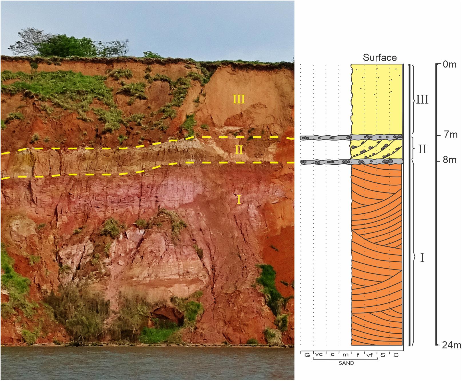
Figure 5. Sedimentary profile of the Paredão das Araras (right margin of the Paraná River). Three distinct sedimentary packages were identified, from base to top: aeolian sandstones with cross stratification of the Caiuá Group (Cretaceous); intermediate package – unconsolidated deposits of fine to medium grained sands, light gray in color, poorly sorted and with pebbles and through cross stratifications that are not very marked; upper package – unconsolidated sediments of fine to medium sand and reddish brown color, with subrounded grains and presence of rounded pebbles.
In Unit 2, sedimentary deposits of gray color are found, composed of quartz of very fine to medium sand size to clay, occasionally with organic nodules. Meanwhile, Unit 3 fluvial deposits are dominated by well sorted, medium to very fine quartz sands, predominantly brown to dark brown in color, with some local grayish coloration. Locally, clay levels, ferruginous, organic nodules and scattered pebbles are found.
The river deposits of Unit 4 are almost completely submerged by the waters of the dam of Porto Primavera. A description of an outcrop found on the Aguapeí river bank (point 2) allowed the collection and dating of three samples at depths of 1, 1.5 and 2.3 m (Figure 6). These samples had ages of 0.7 ± 0.1, 2.3 ± 0.4, and 8.8 ± 1.6 ka, respectively (Table 3). This outcrop presents from base to top: well selected medium sand, through cross stratification, well rounded, with 1 to 15 cm wide clay intraclasts; fine sand with cross lamination and clay levels in the foresets; clay with deformed fine sand levels; fine sand with cross lamination with clay in the foresets, centimetric intercalations of fine sand with clay matrix; massive fine sand and soil derived from alluvial sediments. Thus, it is interpreted that the middle layer of sand with through cross stratifications with intraclasts indicates that the river had a high energy channel around eight thousand years ago; later, clay deposition characterizes the abandonment of the channel and the formation of flood deposits; followed by deposition of fine sand with cross-lamination and clay in the foresets, representing a channel with low energy approximately 2 ka; then, massive clay and sand are probably associated with the abandonment of the channel and the formation of the current marginal dam around 0.7 ka; finally, soil development occurs at the top of the deposit (Figure 6).
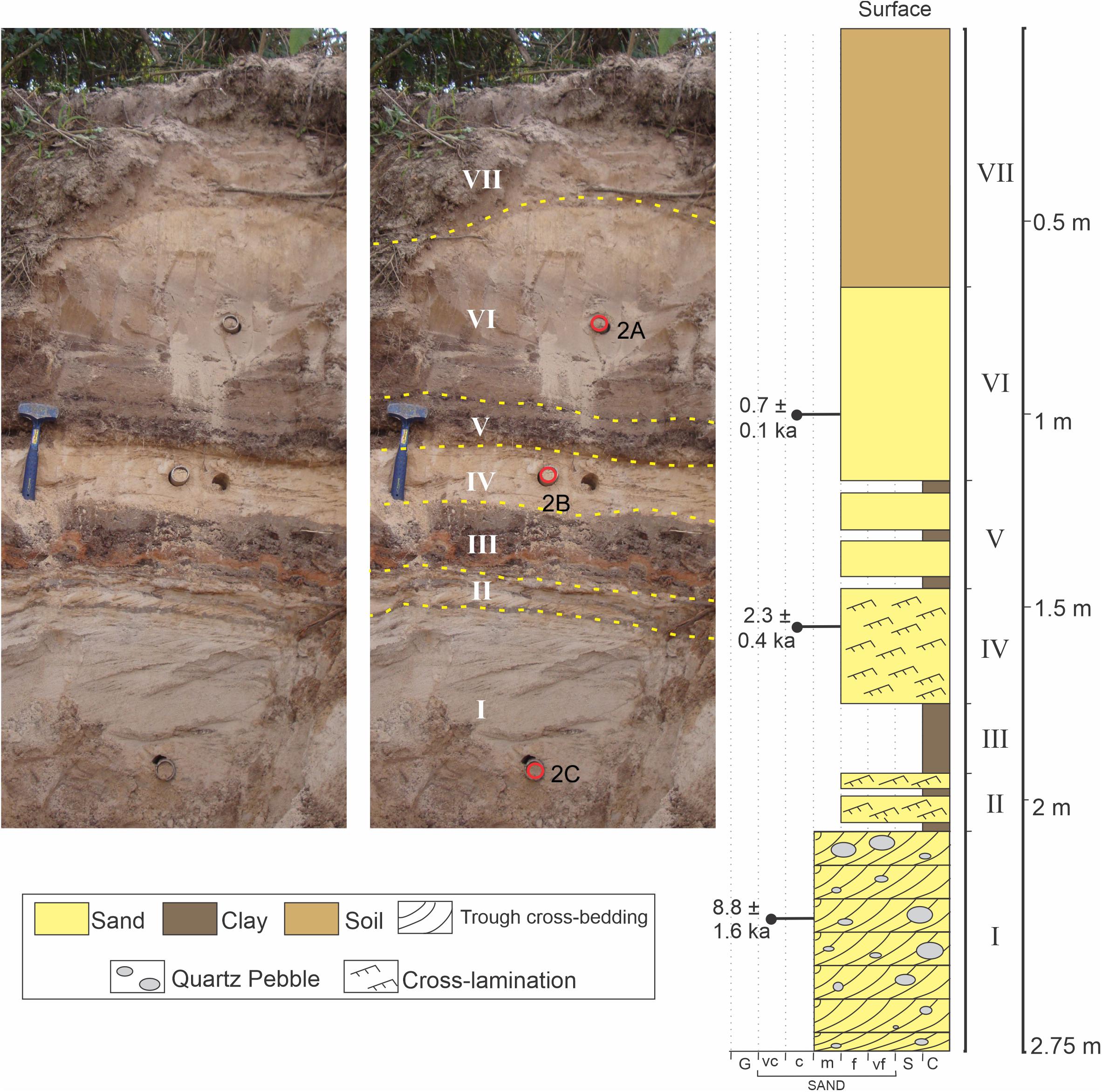
Figure 6. Sedimentary profile described in point 2, located at the margin of Aguapeí River, corresponding to Unit 4. This outcrop presents, from base to top: medium sand, with through cross stratification, with well sorted, well rounded grains and clay intraclasts ranging from 1 to 15 cm; fine sand with cross laminations and clay levels in the foresets; clay with levels of deformed fine sand; fine sand with cross laminations with clay in the foresets, centimetric intercalations of fine sand with clay matrix; fine massive sand and soil from alluvial sediments.
Topobathymetric Profiles
The longitudinal profile of with the Paraná River shown a general concave upward geometry, which may present points with abrupt changes of the topographic gradient (knickpoints), related to tectonic or lithologic controls (Stevaux and Latrubesse, 2017). In the studied fluvial section, two knickpoints are recognized (Figure 7), that seem to be related to the change of lithologies between Caiuá Group sandstones and the Serra Geral Formation basalts, forming a mixed bedrock-alluvial channel bed. The valley is open with a wide fluvial plain in the areas of occurrence of the Bauru Group, narrowing when the river runs on basalt bedrock, where knickpoints can occur (Figure 8). The first knickpoint zone occurs near the mouth of the Verde River and presents itself as rapids popularly known as “Jupiazinho.” Pires Neto et al. (1994) refers to this knickpoint as a significant structural anomaly in which the basaltic outcrops of the river bed form evident rapids in the longitudinal profile. The second knickpoint zone is located downstream of the mouth of the Santo Anastácio River, near the Porto Primavera dam (Figure 7).
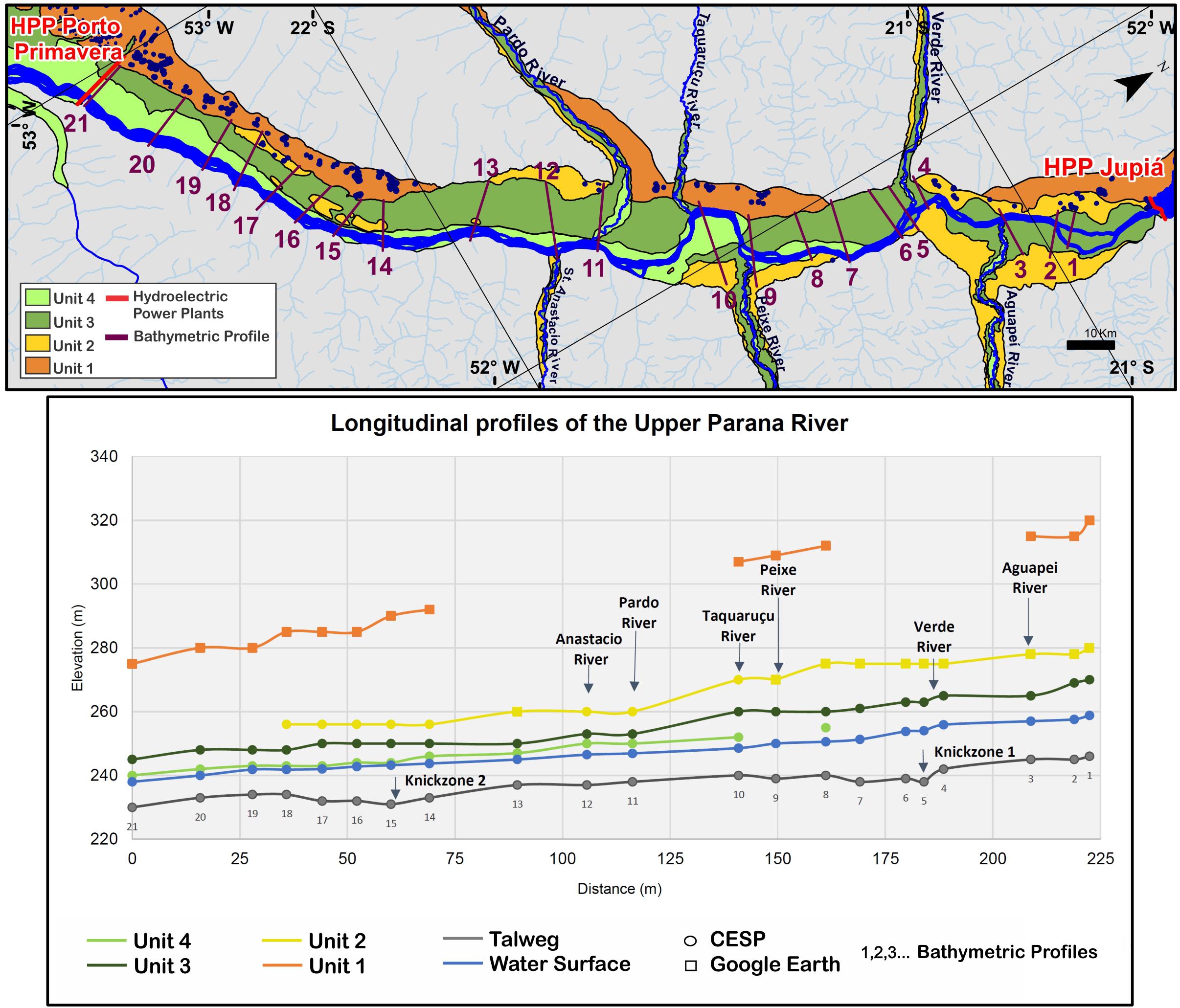
Figure 7. Longitudinal profiles of the current channel and terrace levels identified in the study area. The data was obtained from topobathymetric sections elaborated by Cia Energética de São Paulo [CESP] (1997) and data obtained from Google Earth software. Knickpoints were identified based on present day thalweg profile. The arrows with the names of the tributaries indicate location of the confluences of the tributaries with the Paraná River.
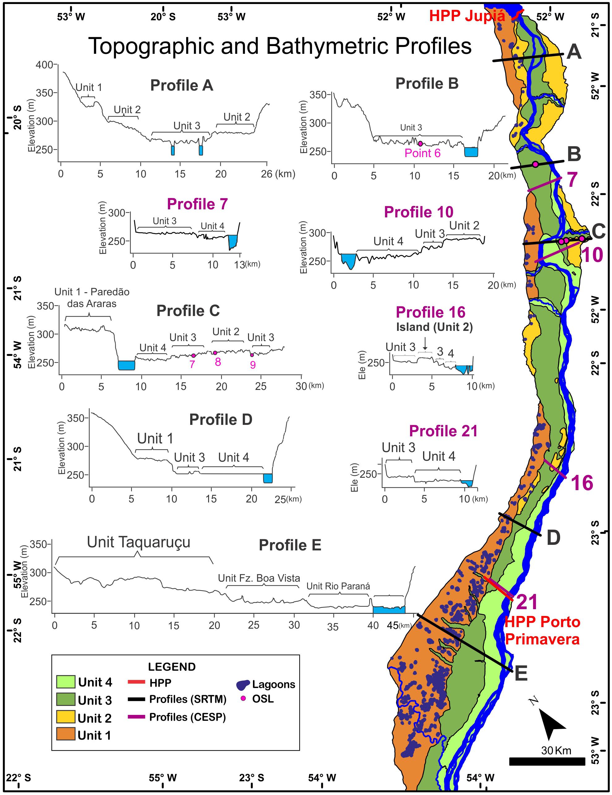
Figure 8. Topographic profiles obtained from SRTM data and topobathymetric profiles elaborated by Cia Energética de São Paulo [CESP] (1997). The profiles help to correlate between the units identified in this research with the units defined by Stevaux (1994). It was also possible to identify geomorphologic units that are currently submerged due the flooding caused by the construction of the Porto Primavera reservoir.
In the studied section, the Paraná River presents low sinuosity with a rectilinear tendency, embedded to the left margin (São Paulo), while most of the fluvial plain is situated on the right bank (Mato Grosso do Sul). However, an exception occurs at the mouth of the Peixe River when the Paraná River abruptly turns to the right side of the bank and erodes the Paredão das Araras escarpment. From this curve, the Paraná River runs along the right bank for approximately 10 km, when it returns to the left bank. This “sinuosity” of the Paraná River, U-shaped at the mouth of the Peixe River, is probably controlled by the sedimentary input of this tributary, that is, the Peixe River has a high sedimentary load that is deposited near its mouth, which causes the drift of the main channel of the Paraná River to the right margin (Figure 9). The same process seems to occur with the Pardo and Verde rivers on the right bank, yet these tributaries direct the river to the left bank. At the mouths of the main tributaries of the Paraná River (Pardo, Verde, Aguapeí, and Peixe) with high sedimentary loads, the fluvial plains open triangularly and develop delta-like shapes, that was also reported by Stevaux (1994, 2000). The sediments deposited by the tributaries at the mouths of these rivers are deposited in the fluvial plains and can be released when the channel migration through their fluvial plain erodes the previously deposited sediments that will be transported downstream (Charlton, 2008).
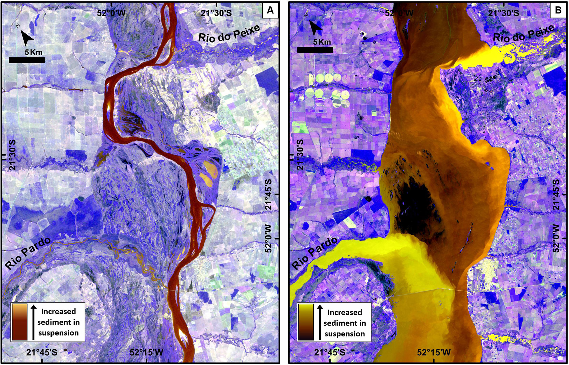
Figure 9. The influence of tributaries in the morphology of the Paraná River. (A) Landsat – 5 image, composition 2R3G4B (August 15, 1985 – before the dam); (B) Landsat – 8 image, composition 3R4G5B (September 21, 2016). The contrast between beige/light yellow which represent the sediments in suspension delivered by the tributaries, and the brown tones that indicate diminished or absent suspended sediments in the Paraná River.
Discussion
The identified geomorphological units in this study have a correlation with those of Stevaux (1994, 2000), located downstream of the studied area (Figure 8). In addition, the combined analysis of morphological, altimetric, sedimentological and sediment deposition ages allowed the interpretation of geomorphological events that were determinant for the evolution of the Upper Paraná River landscape during late Pleistocene and Holocene.
It was verified that the morphological and sedimentary characteristics of the Unit 1 are similar to the Taquaruçu Unit, described by Stevaux (1994, 2000). Both represent the highest terrace level (Figure 8) and are characterized by large circular and semi-circular ponds. The deposits at the base of the Taquaruçu Unit were interpreted by Stevaux (1994) and Kramer and Stevaux (2001) as due dry or semi-arid periods in the Late Pleistocene. Despite the fact that this work did not obtain ages of the sediments of this unit, the data from OSL/MAR (multiple-aliquot regenerative-dose method) dating carried out by Guerreiro (2011) at the base of the Taquaruçu Unit allowed to estimate that the deposition age is between 150.9 ± 32.4 and 50.3 ± 7.9 ka.
Another particularity of Unit 1 is its location predominantly on the right side of the Paraná River. It is noted that the Paraná River channel is drifted to the left bank, running directly over the sandstone of the Caiuá Fm, while its floodplain develops exclusively on its right bank. The left bank is higher, with notable outcroppings of the Caiuá Group, unlike the opposite, right bank, with levels of terraces and a wide fluvial plain. Such asymmetry was explained by Potter and Stevaux (1988) as a consequence of tectonism generated by a local half-graben as a control for these local enlargements of areas associated with the alluvial plain of the Paraná River. However, an exception is made in the Paredão das Araras escarpment, when the Paraná river migrates to the right side where there is a rocky erosive margin covered by deposits of Unit 1. Fulfaro et al. (2005), argued that Paredão das Araras originated by neotectonic processes, after an episode of Late Quaternary reactivation, in which the movement of the Guapiara NW-SE Lineament at its crossing point with the Três Lagoas Shear Zone resulted in the Paredão das Araras feature. Otherwise, we interpret that this abrupt curve of the river is probably influenced by the sedimentary contribution of the Peixe River that led to the development of a delta-like in the zone of confluence with the Paraná River, directing the Paraná River to the left bank and eroding the deposits on the terrace of Unit 1 (Figure 9). Similar process can be observed in confluence zones between other tributaries and the Paraná River (Verde, Peixe, Aguapeí, and Pardo rivers), which is a fundamental factor in the development of channel curves in certain stretches of the Paraná River. On the other hand, straight channel pattern is predominant in the absence of large tributaries, such as the stretch between the Santo Anastácio River and Porto Primavera dam (Figure 2).
Unit 2 corresponds to intermediate terraces (260–280 m altitude), with small ponds and wet areas. This unit does not have characteristics that allow it to be correlated with units presented in previous works (e.g., Stevaux, 1994, 2000; Souza Filho and Stevaux, 1997), and is thus a new geomorphological unit for this reach of the Paraná River. Unit 2 was identified in topographic and topobathymetric profiles, which indicate that this is a lower terrace level than Unit 1 and higher than Unit 3. From its recognition, it was found that the islands located near Porto Primavera dam are traces of this unit. The oldest age obtained for this unit was 60.5 ± 6.1 ka, near the mouth of the Aguapeí River. Oxygen isotope (δ18O) records of caves in southeastern and southern Brazil (Cruz et al., 2005, 2006, 2009) indicate that the climate was drier than present day, a fact that probably favored the deposition of the sediments that constitute Unit 2.
Unit 3 is the lower terrace of the Paraná River, marked by many paleochannels and wetlands (245 to 270 m altitude). This unit presents paleochannels with dimensions and morphologies (multichannel) different from those exhibited by the current channel, therefore relic features of a previous fluvial system. The implementation of the Porto Primavera dam promoted the elevation of the channel’s hydrometric levels. Thus, during flood periods flooding of the floodplain occurs and the paleochannels are partially reactivated, and they can behave as ponds (lentic environments) or as channels (lotic environments), according to current patterns of hydrological connectivity with the current system of the Paraná River and supply from the right side (Rocha et al., 2008).
OSL ages indicate that the deposition of Unit 3 occurred between 39.8 ± 6.9 and 35.8 ± 3.2 ka, making possible its correlation with deposits of the Fazenda Boa Vista Unit, described by Stevaux (1994, 2000). Both units are characterized as a terrace with well-preserved fluvial features, including paleobars and ponds clearly associated to paleochannels (Figure 4E) that suggest a braided river system that occupied a wide plain during the Late Pleistocene (Stevaux, 1994, 2000). The high geomorphic activity that can be deduced from braided river systems points to highly variable discharges (seasonality) and a reduced vegetation cover which in turn lead to an increasing erosion and sediment size and availability in the catchment area and instability of the channel banks and frequent thalweg shift (Schumm, 1981, 2005), suggesting the predominance of arid or semi-arid environmental conditions during the deposition of the Unit 2. Our results agree with previous studies in the lowlands of central South America, that related high fluvial activity with relativity high seasonality climate conditions (semi-arid?) during mostly of the Late Pleistocene. For example, we would highlight the development of braided channels in the Cuiabá and São Lourenço megafans in Pantanal wetland (northern of studied area, 18° to 16°S) with OSL ages from ∼50 to 19 ka (Assine et al., 2014; Pupim et al., 2017) and high fluvial activity with braided rivers and megafans development between ∼55 and 18 ka (14C and OSL ages) in Bolivian Chaco (20° to 16°S) (May et al., 2008; Latrubesse et al., 2012). Moreover, climate conditions reconstructed thought δ18O records of speleothems (Cruz et al., 2005, 2009) and palynological records (Behling, 2002; Ledru et al., 2005) of the southeastern and southern Brazil provide evidences for lower precipitation rates and the predominance of savannah or grassland vegetation cover.
Unit 4 is the current fluvial plain of the Paraná River, with narrow and elongated geometry and parallel to the active channel (265–240 m altitude). Unit 4 was correlated with the Paraná River Unit defined by Stevaux (1994) to downstream of the area studied (Figure 8). The deposition of the sediments of the current fluvial plain of the Paraná River occurs since approximately 8 ka, according to the OSL dating results obtained in this work, which corroborate the results presented by Leli (2015), who found ages of 8,120 years BP (14C) for the sediments obtained from the fluvial plain.
Sedimentary records of the modern fluvial plain deposits of the Aguapeí River indicate that the river presented a channel with a relatively higher energy approximately 8 ka, when the climate was drier than the present one (Prado et al., 2013). Subsequently, about 3–2 ka to the present, the deposition of fine sand with cross-lamination and clay in the foresets occurs, suggesting a channel with low energy, probably meandering. The meandering pattern can be related to wet conditions occurred from 3 ka to the present (Novello et al., 2018).
In general, our data suggest that the evolution of the Upper Paraná River fluvial plain is primary controlled by climate changes during the late Quaternary. The main aggradational phases agree with δ18O records of speleothems (Cruz et al., 2005, 2006, 2009) and pollen records (Behling, 2002; Ledru et al., 2005) from the southeastern and southern Brazil, which document two main phase of very dry conditions and the predominance of savannah or grassland vegetation cover from ∼60 to 50 ka and ∼40 to 27 ka. These conditions appears to be related to weakness of the South American summer monsoon (SASM; Cruz et al., 2005), playing a key role in the development of high activity fluvial systems that lead the deposition of Units 2 and 3. The deposition of the modern plain (Unit 4) may be related also to drier conditions occurred from 8 to 4 ka (Prado et al., 2013; Novello et al., 2017), but under well-developed forest cover (Behling, 2002; Ledru et al., 2005) that reduce the sediment supply and control the development of the modern anabranching channel. The present data do not support paleoclimate inferences from Unit 1, reliable ages are needed. Moreover, taking the depositional ages obtained in this study and assuming the lack of ages as evidence of phases of fluvial incision, we interpret that the two main incision phases occurred from ∼50 to 40 ka and ∼27 to 12 ka, in which higher precipitation (Cruz et al., 2009) combined with a denser vegetation cover (Ledru et al., 2005) may have increased the discharge and stream transport capacity. A similar pattern of channel incision was documented for the megafans in Pantanal in response to an increase in precipitation due to the strengthening of the SASM (Pupim et al., 2017).
Optically Stimulated Luminescence ages obtained in shallow sediments in all geomorphological units suggest reworking processes that may be associated with surface runoff transport or flood events that erode sedimentary deposits along riverbanks and river mouths. An alternative explanation for the asynchronicity of the ages would be the influence of wind activity in the Upper Paraná River region. Parolin and Stevaux (2001) interpreted Holocene sandy deposits found in Taquaruçu, MS, dating from 2.2 ± 0.2 ka to 10.1 ± 1.0 ka, are paleodunes formed by wind processes when the weather was drier than present day.
Conclusion
The fluvial deposits of the Upper Paraná River, in the stretch between the Jupiá and Porto Primavera dams were grouped into four geomorphological zones: Unit 1, elevated terrace, with circular and semicircular ponds; Unit 2, intermediate terrace with small ponds and waterlogged areas; Unit 3, low terrace with well-preserved paleochannels; and Unit 4, current fluvial plain. The absolute ages of sediment deposition of three geomorphological units were determined using the OSL dating and revealed ages of: 60.5 ± 6.1 ka for Unit 2; 39.8 ± 6.9 to 35.8 ± 3.2 ka for Unit 3; 8.8 ± 1.6 to 0.7 ± 0.1 ka for Unit 4.
Topographical, morphological and sedimentary data indicate a correlation between the units 1, 3 and 4, with the Taquaruçu, Fazenda Boa Vista and Paraná River units, respectively, mapped in a reach downstream Porto Primavera dam. An exception is made for Unit 2, which is a unit with singular morphological characteristics and therefore not correlated with units presented in previous works.
Two zones of knickpoints in the studied section were identified that reflect lithological changes along the river channel. It was also observed that the sinuosity of the Paraná River is strongly influenced by the sediment load of its tributaries, which control the main channel position and pattern. OSL ages in some terrace levels present asynchronous terraces originating from the Paraná River, suggesting that the hydrological dynamics of these river systems may be conditioned by different external factors or have undergone reworking by surface runoff and/or wind action after the initial deposition.
In conclusion, the characterization of the Paraná River plain north of the Porto Primavera dam and the correlation with units recognized downstream of the studied area allowed to delineate the quaternary geomorphological evolution of the Upper Paraná River and its relations with climate changes in the scale of thousands of years. Future sedimentological studies and a larger amount of dating are necessary for a more in depth understanding of the formation of these deposits and how the Paraná River respond to Quaternary climate changes.
Data Availability
All datasets generated for this study are included in the manuscript and/or the Supplementary Files.
Author Contributions
SO, MA, and FP elaborated the research project. SO and FP conducted the field work with MA’s logistic support. JS provided the bathymetric data. SO conducted laboratory analysis and data analysis with FP and MA’s support. All authors discussed the data and wrote the manuscript, and approved the final version of the manuscript to be published.
Funding
This work was supported by grant #2014/06889-2, São Paulo Research Foundation (FAPESP, Brazil), National Council for Scientific and Technological Development (CNPq Brazil, grant #144221/2015-2) and CNPq to provide a master’s degree scholarship to SO and the CNPq Productivity Research Fellow to FP and MA (grants #302411/2018-6 and #304925/2017-9).
Conflict of Interest Statement
The authors declare that the research was conducted in the absence of any commercial or financial relationships that could be construed as a potential conflict of interest.
The authors declare a shared affiliation, though no other collaboration, with the authors MA, SO, and JS at the time of review.
Acknowledgments
The authors would like to thank the Laboratory of Gamma Spectrometry and Luminescence of the University of São Paulo (LEGaL-USP), Brazil; Prof. Lucas Warren and graduate students Filipe Varejão, Patrícia Mescolotti, and Mariza Rodrigues from UNESP for their help during field trip; and Amanda S. Catharina for the review and suggestions to improve the manuscript.
Supplementary Material
The Supplementary Material for this article can be found online at: https://www.frontiersin.org/articles/10.3389/feart.2019.00200/full#supplementary-material
References
Assine, M. L., Corradini, F. A., Pupim, F. N., and McGlue, M. M. (2014). Channel arrangements and depositional styles in the São Lourenço fluvial megafan, Brazilian Pantanal wetland. Sediment. Geol. 301, 172–184. doi: 10.1016/j.sedgeo.2013.11.007
Behling, H. (2002). South and southeast Brazilian grasslands during late quaternary times: a synthesis. Palaeogeogr. Palaeoclimatol. Palaeoecol. 177, 19–27. doi: 10.1016/s0031-0182(01)00349-2
Bridgland, D., and Westaway, R. (2008). Climatically controlled river terrace staircases: a worldwide quaternary phenomenon. Geomorphology 98, 285–315. doi: 10.1016/j.geomorph.2006.12.032
Cia Energética de São Paulo [CESP], (1997). Seções Batimétricas do Rio Paraná no Trecho Entre Porto Primavera e Jupiá. Ref. CESP CT/ERC/3011/97. São Paulo: Cia Energética de São Paulo.
Cruz, F. W., Burns, S. J., Karmann, I., Sharp, W. D., and Vuille, M. (2006). Reconstruction of regional atmospheric circulation features during the Late Pleistocene in subtropical Brazil from oxygen isotope composition of speleothems. Earth Planet. Sci. Lett. 248, 494–506. doi: 10.1016/j.epsl.2006.06.019
Cruz, F. W., Burns, S. J., Karmann, I., Sharp, W. D., Vuille, M., Cardoso, A. O., et al. (2005). Insolation-driven changes in atmospheric circulation over the past 116 ky in subtropical Brazil. Nature 434, 63–66. doi: 10.1038/nature03365
Cruz, F. W., Wang, X., Auler, A., Vuille, M., Burns, S. J., Karmann, I., et al. (2009). “Orbital and millennial-scale precipitation changes in Brazil from speleothem records,” in Past Climate Variability from the Last Glacial Maximum to the Holocene in South America and Surrounding Regions: Developments in Paleoenvironmental Research, eds F. Vineux, F. Sylvestre, and M. Khodricpesnm, (Berlin: Springer-Verlag), 29–60. doi: 10.1007/978-90-481-2672-9_2
Fulfaro, V. J., Etchebehere, M. L., Saad, R. A., and Perinotto, A. J. (2005). The Araras Escarpment in the upper Paraná River: implications to fluvial neotectonics on the Paraná drainage net evolution. Rev. Bras. Geomorfol. 6, 115–122. doi: 10.20502/rbg.v6i1.45
Galbraith, R. F., Roberts, R. G., Laslett, G. M., Yoshida, H., and Olley, J. M. (1999). Optical dating of single and multiple grains of quartz from Jinmium Rock Shelter, Northern Australia: part I, experimental design and statistical models. Archaeometry 41, 339–364. doi: 10.1111/j.1475-4754.1999.tb00987.x
Guérin, G., Mercier, N., and Adamiec, G. (2011). Dose-rate conversion factors: update. Ancient TL 29, 5–8.
Guerreiro, R. L. (2011). Evolução Geomorfológica e Paleoambiental dos Terraços da Margem Esquerda do Alto Rio Paraná. Ph. D Dissertation/master’s thesis. Universidade Estadual Paulista: Rio Claro, SP.
Guerreiro, R. L., Stevaux, J. C., Parolin, M., and Assine, M. L. (2013). Late Pleistocene and Holocene paleoenvironments in ponds and aluvial sediments of the Upper Paraná River, Brazil. Rev. Bras. Paleontol. 16, 39–46. doi: 10.4072/rbp.2013.1.03
Jain, M., Bøtter-Jensen, L., and Singhvi, A. K. (2003). Dose evaluation using multiple-aliquot quartz OSL: test of methods and a new protocol for improved accuracy and precision. Radiat. Meas. 37, 67–80. doi: 10.1016/s1350-4487(02)00165-8
Kramer, V. M. S., and Stevaux, J. C. (2001). Mudanças climáticas na região de Taquaruçu (MS) durante o Holoceno. Boletim Paranaense de Geociências 49, 79–91. doi: 10.5380/geo.v49i0.4127
Latrubesse, E. M., Stevaux, J. C., Cremon, E. H., May, J. H., Tatumi, S. H., Hurtado, M. A., et al. (2012). Late quaternary megafans, fans and fluvio-aeolian interactions in the Bolivian Chaco, Tropical South America. Palaeogeogr. Palaeoclimatol. Palaeoecol. 356, 75–88. doi: 10.1016/j.palaeo.2012.04.003
Latrubesse, E. M., Stevaux, J. C., Santos, M. L., and Assine, M. L. (2005). “Grandes sistemas fluviais: geologia, geomorfologia e paleohidrologia,” in Quaternáriono Brasil, eds C. R. G. Souza, K. Suguio, A. M. S. Oliveira, and P. E. Oliveira, (Ribeirão Preto: Holos Editora), 276–297.
Ledru, M.-P., Rousseau, D.-D., Cruz, F. W. Jr., Riccomini, C., Karmann, I, Martin, L., et al. (2005). Paleoclimate changes during the last 100,000 yr from a record in the Brazilian Atlantic rainforest region and interhemispheric comparison. Quat. Res. 64, 444–450. doi: 10.1016/j.yqres.2005.08.006
Leli, I. T. (2015). Gênese, Evolução e Geomorfologia das Ilhas e Planície de Inundação do Alto rio Paraná, Brasil. PhD Thesis. Universidade Estadual Paulista: Rio Claro, SP.
Leli, I. T., Stevaux, J. C., and Assine, M. L. (2017). Genesis and sedimentary record of blind channel and islands of the anabranching River: an evolution model. Geomorphology 293, 110–130. doi: 10.1016/j.geomorph.2017.05.001
May, J. H., Zech, R., and Veit, H. (2008). Late Quaternary paleosol–sediment-sequences and landscape evolution along the Andean piedmont, Bolivian Chaco. Geomorphology 98, 34–54. doi: 10.1016/j.geomorph.2007.02.025
Merino, E. R., Pupim, F. N., Macedo, H. A., and Assine, M. L. (2015). Realce e integração de imagens orbitais óticas com dados SRTM para mapeamento e estudo de grandes planícies fluviais: exemplos de aplicação no Pantanal. Rev. Bras. Geomorfol. 16, 49–62. doi: 10.20502/rbg.v16i1.626
Murray, A. S., and Wintle, A. G. (2000). Luminescence dating of quartz using an improved single-aliquot regenerative-dose protocol. Radiat. Meas. 32, 57–73. doi: 10.1016/S1350-4487(99)00253-X
Murray, A. S., and Wintle, A. G. (2003). The single aliquot regenerative dose protocol: potential for improvements in reliability. Radiat. Meas. 37, 377–381. doi: 10.1016/S1350-4487(03)00053-2
Nelson, M. S., Gray, H. J., Johnson, J. A., Rittenour, T. M., Feathers, J. K., and Mahan, S. A. (2015). User guide for luminescence samplings in archaeological and geological contexts. Adv. Archaeol. Pract. 3, 166–177. doi: 10.7183/2326-3768.3.2.166
Novello, V. F., Cruz, F. W., Vuille, M., Stríkis, N. M., Edwards, R. L., Cheng, H., et al. (2017). A high-resolution history of the South American Monsoon from Last Glacial Maximum to the Holocene. Sci. Rep. 7:44267. doi: 10.1038/srep44267
Novello, V. F., Cruz, F. W., Mosquet, J. S., Vuille, M., Paula, M. S., Nunes, D., et al. (2018). Two millennia of South Atlantic convergence zone variability reconstructed from isotopic proxies. Geophys. Res. Lett. 45, 1–7. doi: 10.1029/2017GL076838
Orfeo, O., and Stevaux, J. C. (2002). Hydraulic and morphological characteristics of middle and upper reaches of the Paraná River (Argentina and Brazil). Geomorphology 44, 309–322. doi: 10.1016/s0169-555x(01)00180-5
Parolin, M., Medeanic, S., and Stevaux, J. C. (2006). Registros palinológicos e mudanças ambientais durante o Holoceno de Taquarussu (MS). Rev. Bras. Paleontol. 1, 137–148. doi: 10.4072/rbp.2006.1.14
Parolin, M., and Stevaux, J. C. (2001). Formação de Dunas Eólicas Durante o Holoceno Médio em Taquaruçu, Mato Grosso do Sul. Pesquisas em Geociências 28, 43–46. doi: 10.22456/1807-9806.20298
Parolin, M., Volkmer-Ribeiro, C., and Stevaux, J. C. (2007). Sponge spicules in peaty sediments as paleoenvironmental indicators of the Holocene in the upper Paraná River, Brazil. Rev. Bras. Paleontol. 10, 17–26. doi: 10.5380/abequa.v9i2.51816
Pazzaglia, F. J. (2013). “Fluvial terraces,” in Treatise on Geomorphology, ed. Shrodercpesnm, (San Diego, CA: Academic Press), 379–412. doi: 10.1016/b978-0-12-374739-6.00248-7
Pires Neto, A. G., Bartorelli, A., and Vargas, M. S. (1994). A planície do rio Paraná. Boletim Paranaense de Geociências 42, 217–229.
Potter, P. E., and Stevaux, J. C. (1988). Stratigraphy and Sedimentation of the Alluvial Plain of the Paraná River, State of Paraná, Brazil: Comprehensive, Three-Dimensional Sedimentary Model for a Tropical River. A Proposal to The Petroleum Research Fund. Washington D. C: American Chemical Society, 9.
Prado, L. F., Wainer, I., Chiessi, C. M., Ledru, M., and Turcq, B. J. (2013). A mid Holocene climate reconstruction for eastern South America. Clim. Past 9, 2117–2133. doi: 10.5194/cp-9-2117-2013
Prescott, J. R., and Hutton, J. T. (1994). Cosmic ray contributions to dose rates for luminescence and ESR dating: large depths and long-term time variations. Radiat. Meas. 23, 497–500. doi: 10.1016/1350-4487(94)90086-8
Pupim, F. N., Assine, M. L., and Sawakuchi, A. O. (2017). Late Quaternary Cuiabá megafan, Brazilian Pantanal: channel patterns and paleoenvironmental changes. Quat. Int. 438, 108–125. doi: 10.1016/j.quaint.2017.01.013
Rhodes, E. J. (2011). Optically stimulated luminescence dating of sediments over the past 200,000 years. Annu. Rev. Earth Planet. Sci. 39, 461–488. doi: 10.1146/annurev-earth-040610-133425
Rocha, P. C., Bombonato, A. C., Silva, L. M., Brandão, F., and Andrade, I. R. A. (2008). “Geomorfologia e reativação de paleocanais em uma área de influência do reservatório da UHE Porto Primavera, Planície do rio Paraná, Centro-Sul do Brasil,” in Proceedings of the 7th Sinageo/2nd Encontro Latino-Americano de Geomorfologia Meeting on 2008, (Belo Horizonte: VII Sinageo).
Sallun, A. E. M., and Suguio, K. (2007). Datação absoluta por luminescência do alogrupo Alto Rio Paraná (SP, PR e MS). Rev. Instit. Geol. 27, 13–29. doi: 10.5935/0100-929x.20070002
Sallun, A. E. M., Suguio, K., and Stevaux, J. C. (2007). Proposição formal do alogrupo Alto Rio Paraná (SP, PR e MS). Geol. USP Sér. Científ. 7, 49–70. doi: 10.5327/Z1519-874X2007000200004
Santos, M. L., and Stevaux, J. C. (2000). Facies and architectural analysis of channel sandy macroforms in the Upper Paraná River. Quat. Int. 72, 87–94. doi: 10.1016/S1040-6182(00)00024-0
Schumm, S. A. (1981). Evolution and response of the fluvial system, sedimentologic implications. Soc. Econ. Paleontol. Mineral 31, 19–29. doi: 10.2110/pec.81.31.0019
Soares, P. C., and Fiori, A. P. (1976). Lógica e sistemática na análise e interpretação de fotografias aéreas em geologia. Notícia Geomorfol. 16, 71–104.
Souza Filho, E. E., and Stevaux, J. C. (1997). “Geologia e geomorfologia do complexo rio Baía, Curutuba, Ivinheima,” in A Planície de Inundação do Alto Rio Paraná: Aspectos Físicos, Biológicos e Socioeconômicos, eds A. M. Vazzoler, A. A. Agostinho, and N. S. Hahncpesnm, (Maringá: EDUEM), 3–46.
Stevaux, J. C. (1994). Upper Paraná River (Brazil) geomorphology and paleoclimatology. Quat. Int. 21, 143–161. doi: 10.1016/1040-6182(94)90028-0
Stevaux, J. C. (2000). Climatic events during the Late Pleistocene and Holocene in the Upper Paraná River: correlation with NE Argentina and South-Central Brazil. Quat. Int. 72, 73–85. doi: 10.1016/S1040-6182(00)00023-9
Stevaux, J. C., and Souza, I. A. (2004). Floodplain construction in an anastomosed river. Quat. Int. 114, 55–65. doi: 10.1016/s1040-6182(03)00042-9
Vandenberghe, J. (1995). Timescales, climate and river development. Quat. Sci. Rev. 14, 631–638. doi: 10.1016/0277-3791(95)00043-o
Keywords: Paraná River, fluvial terraces, OSL dating, tropical rivers, Quaternary geology
Citation: Oliveira SC, Pupim FN, Stevaux JC and Assine ML (2019) Luminescence Chronology of Terrace Development in the Upper Paraná River, Southeast Brazil. Front. Earth Sci. 7:200. doi: 10.3389/feart.2019.00200
Received: 14 May 2019; Accepted: 22 July 2019;
Published: 06 August 2019.
Edited by:
Giancarlo Scardia, São Paulo State University, BrazilReviewed by:
Noureddine Elmejdoub, University of Gabès, TunisiaLi Wu, Anhui Normal University, China
Copyright © 2019 Oliveira, Pupim, Stevaux and Assine. This is an open-access article distributed under the terms of the Creative Commons Attribution License (CC BY). The use, distribution or reproduction in other forums is permitted, provided the original author(s) and the copyright owner(s) are credited and that the original publication in this journal is cited, in accordance with accepted academic practice. No use, distribution or reproduction is permitted which does not comply with these terms.
*Correspondence: Stefania C. Oliveira, c3RlZi5vbGl2ZWlyYUB5YWhvby5jb20uYnI=