 Heather A. L. Knight
 Chelsea Beebe2
- 1Natural Conservation Solutions, LLC, Livermore, CO, United States
- 2The Nature Conservancy of Colorado, Boulder, CO, United States
- 3Coalition for the Poudre River Watershed, Fort Collins, CO, United States
- 4Colorado State University, Colorado Natural Heritage Program, Fort Collins, CO, United States
For more than 50 years, the United States (US) Endangered Species Act (ESA) has contributed to the protection, survival, and recovery of numerous species including gray wolves (Canis lupus), grizzly bears (Ursus arctos horribilis), whooping cranes (Grus americana), and spotted owls (Strix occidentalis). Recovery efforts by US federal agencies have largely focused on these well-known, charismatic species. As a result, lesser-known species have often been given lower priority and limited funding. An additional challenge to species recovery has been that ~ 50% of listed species have at least part of their habitats on private lands. Private landowners have sometimes viewed contributing to species recovery as an infringement on property rights. The Preble’s Meadow Jumping Mouse, Zapus hudsonius preblei, (PMJM) is a riparian specialist that serves as an indicator species for the ecological integrity of first and second-order watersheds in the Rocky Mountain region of the US. In 1998, PMJM was listed as a threatened species by the US Fish and Wildlife Service (USFWS). The listing process was prolonged by numerous lawsuits. After two different recovery teams and 21 years to produce a Recovery Plan, the USFWS recognized the need for a different approach to listed species recovery. The result, in 2019, was the establishment of the first Site Conservation Team (SCT) by the USFWS. This new SCT model uniquely combined: community-based participation and collaboration, private landowner leadership of process development and conservation action, extensive community outreach, a scientific foundation, and emphasized watershed health. The establishment of SCTs to address species conservation marked a new era taken by the USFWS. Herein we discuss the PMJM SCT located within the North Fork of the Cache la Poudre River watershed (North Fork SCT) in Northern Colorado. We identify conditions that enabled the new approach, describe the collaborative process, report how community engagement can address fears and lead to shared understanding of environmental benefits, and result in restoration actions that contribute to the species recovery. The North Fork SCT successfully nominated a recovery population nomination, developed a comprehensive conservation plan, and initiated restoration on 102 stream miles of potential habitat for approximately 4,000 PMJM individuals.
1 Introduction
The Preble’s meadow jumping mouse (PMJM), Zapus hudsonius preblei, is a small (~25g) rodent found along riparian and wetland areas of southeastern Wyoming and southward along the Piedmont physiographic region east of the Colorado Front Range to Colorado Springs, Colorado (see Figure 1). The Front Range is approximately a 180 mile long, and 40 mile wide, Laramide uplift of the Southern Rocky Mountains, and includes 14,000-ft peaks and steep north-south mountainous terrain just west of major cities, like Denver, Boulder, and Fort Collins, Colorado (Sonnenberg and Bolyard, 1997).
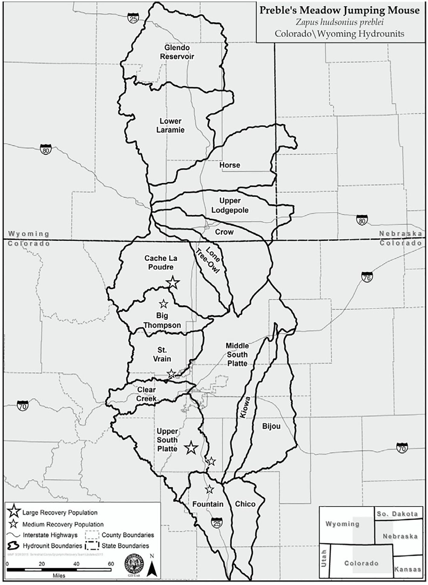
Figure 1. Hydrologic Unit Codes (HUCs) in Colorado and Wyoming with location of potential large and medium-sized Preble’s Meadow Jumping Mouse (Zapus hudsonius preblei) recovery populations (USFWS, 2018).
This subspecies of meadow jumping mouse (Zapus hudsonius) was listed as Threatened under the US Endangered Species Act due to habitat loss. The PMJM’s narrow distribution overlaps with one of the fastest growing urban and suburban areas in the US (Baron et al., 2004). Human population growth fragmented and degraded riparian and wetland habitat for the species and led the US Fish and Wildlife Service (USFWS) to list it as federally threatened in May,1998.
The main factor that threatened the PMJM was the decline in the extent and quality of riparian habitat (USFWS, 2018). Accelerated human population growth along Colorado’s Front Range since the early 1990s resulted in habitat alteration, degradation, loss, and fragmentation (USFWS, 2018). Most impacts were caused by exurban residential and commercial development, flood control, intensive agricultural activities, and water developments (Baron et al., 2004; Kuby et al., 2007). Habitat destruction can directly impact individual mice, destroying nest sites, food resources and hibernation sites, disrupting behavior, fragmenting habitats, or creating barriers to movement (USFWS, 2018). Despite these impacts, suitable habitat for the PMJM still exists and has been maintained by conservation efforts (USFWS, 2018). In some circumstances, habitat for PMJM can be restored or improved using compatible land management practices (Bakeman, 2005; Frey, 2018). Recolonization of restored habitat by the PMJM would decrease the time required for recovery and delisting. However, such restoration requires collaboration, trust, and targeted efforts by landowners.
Building trust with private landowners can be challenging for species recovery, but it is critical for successful natural resource management (Davenport et al., 2007). Because the PMJM was understudied in the 1990s, there was limited information on life history and ecology to guide conservation and management practices. Gaps in knowledge specific to PMJM, reliance on knowledge of other meadow jumping mouse subspecies, and conflicting genetic analyses fueled community mistrust. Consequently, significant controversy surrounded the listing and designation process. These issues resulted in legal actions and a lengthy recovery planning process.
Ultimately two Recovery Teams worked over 21 years to develop and finalize the PMJM Recovery Plan (Plan). The first Recovery Team was established in early 2000. Critical habitat was finally designated as approximately 411 miles of rivers and streams and 34,935 acres of streamside habitat in seven Colorado counties. The Recovery Team completed the Plan in 2018 (USFWS, 2018).
Lessons learned during the process used to list the species resulted in a unique approach to recovery. First, the Plan was based on a watershed approach (see Figure 1). The Plan recognized each watershed’s specific natural history features and human land use context. Second, the Plan’s recovery goal was focused on suitable, connected habitat occupied by the PMJM populations that were stable or increasing over a 10-year period. Population density estimates from throughout the PMJM range were used to project the amount of habitat needed for recovery populations. Lastly, recognizing the critical role of private lands for recovery, and because of long-established local conservation efforts, (e.g., Livermore Habitat Conservation Plan; LAHCP, 2005), the USFWS established for the first time a collaborative conservation approach for recovery.
The ESA has been a successful protection program for many species across the US. However, implementation of the process has continued to be difficult and expensive for achieving delisting and recovery of most of the listed species (Evans et al., 2016). Some of the challenges have included lack of persistent and consistent funding across species, partnerships among federal, state, nongovernmental and private landowners, and efficient monitoring programs to inform adaptive management of species (Evans et al., 2016). Acknowledging these issues, the Recovery Team directed the creation of Site Conservation Teams (SCT) to address these challenges with solution-oriented processes.
2 Community and conservation history
The North Fork of the Cache la Poudre River (North Fork Poudre) is a 400,000-acre watershed approximately 20 miles wide and 10 miles deep paralleling the Colorado-Wyoming border (see Figure 2). This watershed remains one of the last places along Colorado’s northern Front Range to support large, connected extents of native ecosystems. Archeological records from 11,000 years ago indicate the seasonal movement of people following wildlife using streams as pathways and corridors. Anglo activity started with trapping and mining in the early to mid-1800s. By the late 1800s, ranching was established and became the most sustainable land use for this high desert producing local food and fiber, and supporting wildlife and ecosystem function. Change came rapidly in the early to mid-1990s as Colorado experienced a land rush with people moving from city to country spurred by population growth, opportunity to work remotely using virtual technologies, and an aging agricultural industry (Knight, 1996). The ranching and conservation community realized that irreversible land use change was imminent and both groups would lose significant wildlife habitat and compatible livelihoods if they were unable to cooperate. The result was a community-based, collaborative conservation effort. Starting in the early 1990s, private landowners, non-profit conservation groups, and city, county, state and federal natural resource agencies collaborated to conserve over 120,000 acres of private lands and connect them to the existing 220,000 acres of public lands. In addition, community members adopted land management practices to maintain and improve land health, including management of noxious weeds, prescribed fire and grazing practices, protection of water sources, limited development, and appropriate recreational use. The project became known as the Laramie Foothills (The Nature Conservancy, 2007).
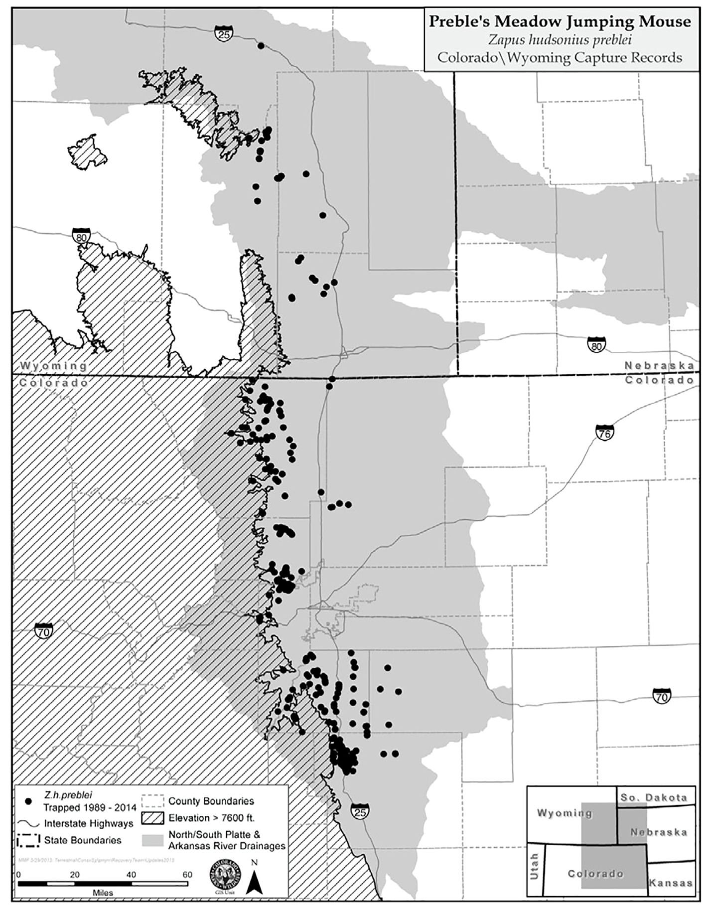
Figure 2. Distribution of the Preble’s Meadow Jumping Mouse (Zapus hudsonius preblei) and capture localities in Colorado and Wyoming through 2014 (USFWS, 2018).
In 1994 a diverse group of stakeholders interested in co-creating conservation solutions for people and nature in the North Fork watershed formed the Laramie Foothills Advisory Group (LFAG). After the PMJM was listed in 1998, members of the LFAG approached the USFWS and proposed an approach built on past conservation efforts that rewarded good stewardship of wildlife habitat. A habitat conservation plan (HCP) with a strong level of community engagement and oversight was crafted by the LFAG and was approved by the USFWS in 2007 (Livermore Area Landowners Group et al., 2005). Members of the LFAG were invited to meet with the USFWS as the PMJM Recovery Team and Recovery Planning process were initiated. Subsequently, the Recovery Team incorporated the HCP’s community-based approach into the Recovery Plan for the PMJM.
3 New approach to recovering listed species
The new SCT model uniquely combined a focus on community-based participation, employed a collaborative approach, engaged private landowners as leaders in process development and conservation action, included extensive community outreach and engagement, was science-driven, and emphasized watershed health.
The USFWS Recovery Plan directed the formation of SCTs to “nominate recovery populations, identify threats and means through which to manage threats, and reach out to communities with this information. SCTs were to be composed of community stakeholders such as federal, state, and local government agencies, nonprofit entities, and private landowners” (USFWS, 2018). SCTs were tasked with assessing habitat quality within watersheds (see Figure 3) in Colorado and Wyoming that are capable of supporting Large (at least 2,500 mice within a network of 57 miles of connected streams), Medium (at least 500 mice within 11 miles of connected streams) and Small (occupied within 3 miles of connected streams) populations. PMJM populations would be nominated to serve as recovery populations whose abundance and trend will be monitored for 10 years. SCTs would develop Threat Abatement and Conservation Plans, to identify local and regional impacts and activities, potential management actions, and opportunities for habitat improvement, including funding and support resources.
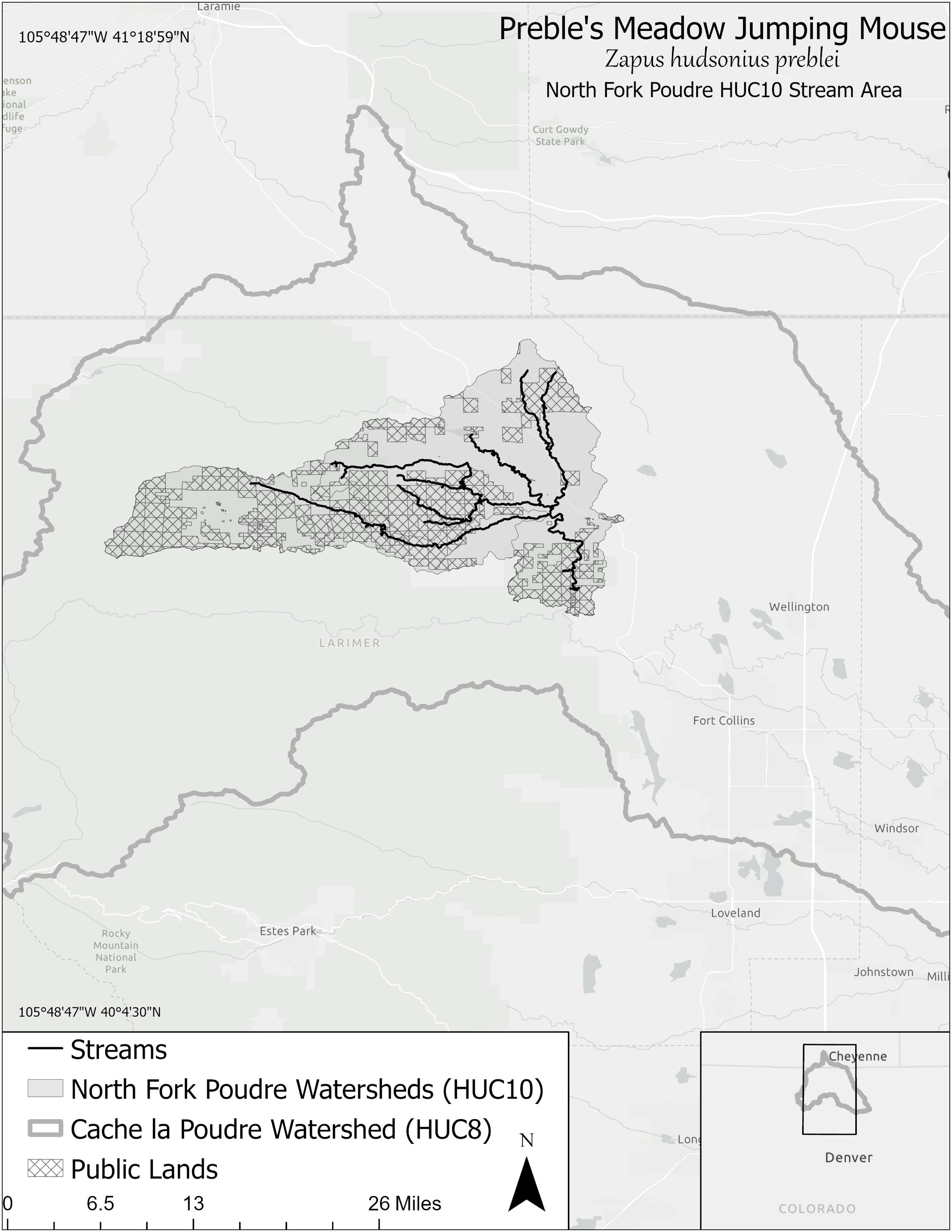
Figure 3. Project area and major tributary streams of the North Fork Poudre Site Conservation Team within both the Cache la Poudre watershed (Hydrologic Unit Code 8) and the North Fork Poudre watershed (Hydrologic Unit Code 10) located in Northern Colorado.
The first SCT was established in 2019 in the North Fork Poudre Watershed. The North Fork SCT was selected to concurrently develop and implement this new approach, thereby creating a template and foundation for other SCTs. A history of over 30 years of community-based conservation in the watershed, a track record of working across private and public boundaries, and significant commitment of private landowners and public land managers to conservation were factors that drove the selection of the North Fork as a starting point for this new approach to listed species conservation.
Twenty-two members and eight alternates comprised the Nork Fork SCT representing four private landowners, four non-profit NGOs, five local government municipalities, three federal agencies, five state natural resource agencies, and one for-profit conservation entity. A charter was adopted to define SCT member roles and responsibilities. A chairperson position was set for 2-year terms to facilitate the SCT and coordinate with the USFWS staff. Decision making was by consensus. The North Fork SCT met every two or three months to move goals and objectives forward as described in the SCT timeline (see Figure 4). Subcommittees were formed to design and execute activities with guidance and support from all SCT members.
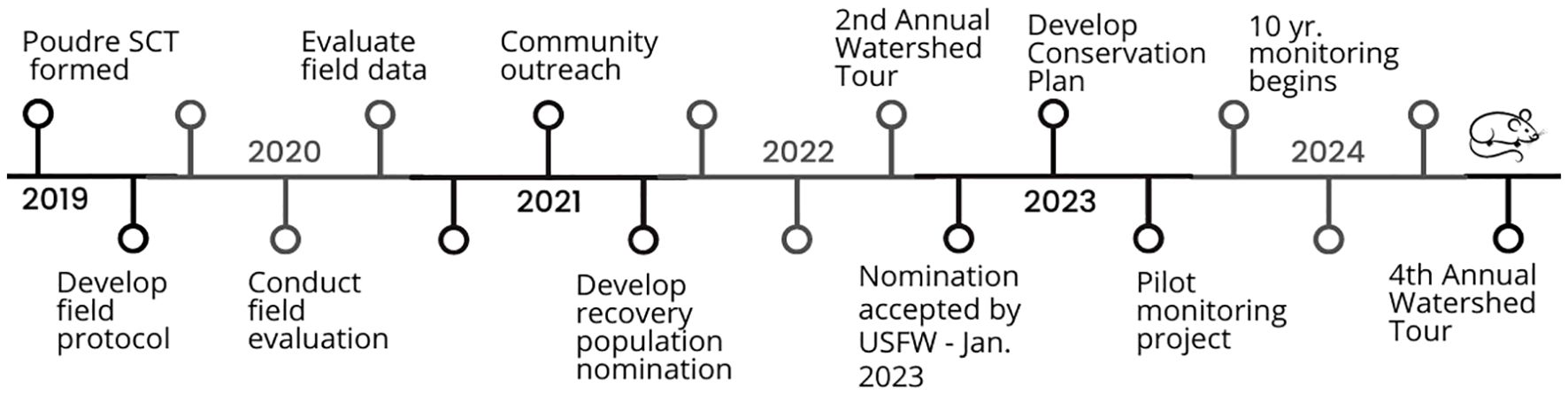
Figure 4. Site Conservation Team (SCT) timeline spanning from 2019 to 2024. Created by North Fork Poudre SCT to highlight completed and scheduled objectives, goals, and accomplishments.
The North Fork SCT adopted the following key principles:
Community-Based Participation. SCT members were selected based on their credibility, local community connections, hands-on local knowledge, capacity to fully participate, personal or professional alignment with project goals, and commitment to collaboration. Private landowners were represented to reflect the proportion of private lands. All public land management agencies and conservation nonprofits with local interests were invited to be represented. Appendix 1 is a listing of SCT members and collaborators.
Community Outreach. Outreach in the community started at the very beginning of the process (2019) and was projected to continue at least through 2034. A variety of modes of communication, including meetings, newsletters, website (www.northforkpoudresct.com) and events, have been used to share information, invite dialogue and encourage participation.
Collaborative Process. The process was collaboratively developed by the SCT with input from landowners and organizations of interest. The process was designed to be based on trust, open and inclusive communication, transparency, respect, a focus on a common mission of watershed health for people and wildlife, and sensitivity to different values. Language and a positive approach was recognized as critical, as was the concept of learning-by-doing using an experimental approach.
Private Landowner Leadership. The SCT process has been community led with the SCT chair(s) being locally known as credible individuals in the watershed and amongst partner organizations. The USFWS assigned a liaison position for all SCTs and hired the position with an emphasis on commitment to collaboration, community engagement, and science.
Science-Based. The use of good scientific information has been a hallmark of the SCT model. Goals, objectives, and activities have been formulated using the best available information. An understanding of both ecology and the logistical challenges in species recovery have been required to conduct field monitoring, develop detailed habitat assessments, estimate population abundances, and create a restoration plan.
Watershed Health Approach. The SCT chose to focus on maintaining a healthy watershed for people and nature. The basis for this approach included perceptions associated with the ESA, existing support for restoration of rivers and riparian habitat, and lack of concern for a seldom-seen mouse. Acknowledgment of past conservation efforts and reward for good stewardship practices amongst neighbors and across boundaries set a positive, collaborative tone and encouraged broader community participation. Identification and abatement of threats was avoided, while the maintenance and improvement of suitable habitat was emphasized. To support this approach, watershed tours illustrated examples of different habitat conditions and restorative practices, a shared library of local reference photos exemplified High, Medium and Low quality habitat, and Fact Sheets were created to describe land management practices and connected landowners to resource partners and funding.
4 Site conservation team process
The North Fork SCT identified a network of streams that cumulatively provided 102 miles of connected PMJM habitat with an estimated population of approximately 4,000 adult mice. Streams included the North Fork Poudre River (between Halligan Reservoir and Milton Seaman Reservoir), Lone Pine Creek, Rabbit Creek, Stonewall Creek, and Tenmile Creek. Selection of streams was based on a variety of factors, including suitable habitat (focus on dense riparian shrubs, grasses, and forbs), minimal anthropogenic disturbances, and connected riparian systems that lacked barriers to movement. PMJM population estimates were derived from habitat suitability ratings and population densities from nearby watersheds on the Colorado Front Range as described in the Recovery Population Nomination (Nomination) section below. Stream miles by land ownership within this proposed Recovery Population included: USFS lands (12 miles), State Wildlife Areas (27 miles), State Land Board lands (2.5 miles), The Nature Conservancy (4.1 miles), private lands with conservation easements (13.5 miles), other private lands (40.3 miles) and other lands (2.8 miles).
Approximately 60 percent of stream miles for the proposed Recovery Population occurred on public lands and formally protected private lands and, therefore, were likely to continue to provide PMJM habitat into the future. Compatible land uses occurred on much of the remaining private lands within the proposed Recovery Population area. This landscape is composed of extensive areas of riparian vegetation that has provided suitable habitat for PMJM due to the long, and collaborative history of conservation in the watershed.
4.1 Habitat quality assessment and evaluation of potential recovery population
After the SCT was formed, an evaluation of the potential size of the Recovery Population was initiated. This task required a determination of where suitable habitat was located and an assessment of habitat suitability for PMJM. The SCT surveyed the watershed to characterize different habitat types and land uses across all major streams. Habitat conditions of stream sections were filmed to record site differences for later reference. Remotely sensed data and habitat and stream models were used to locate variables hypothesized to be important to PMJM. SCT members and partner organizations shared existing field data including hydrology, vegetation, and PMJM trapping data. Because historic and remotely sensed data were considered to inaccurately depict current conditions, the SCT decided to ground truth potential habitat along streams. A field sampling protocol was developed to quickly record basic measurements of PMJM habitat suitability. Sampling sites were randomly identified across all streams in the watershed. Some sampling points were removed because of landowner permission, ease of access, or SCT capacity. Seventy-six points were selected and plotted on a georeferenced map. Landowner permission could not be obtained for four of the sampling points. SCT members volunteered to conduct field sampling and were trained to use the data collection techniques. The training minimized observer bias and increased accuracy. Field data was reviewed by all SCT members to describe three categories of habitat quality: High, Medium and Low. A series of reference photos illustrating each habitat category were selected. SCT members collectively assigned habitat ratings of High, Medium and Low across all stream reaches by using a combination of local knowledge, field data, and remote data. A Conservation Working Area Map was created showing habitat quality ratings for five streams in the watershed.
4.2 Recovery population nomination
Once suitable habitat was identified and habitat ratings assigned, population density was estimated. Because no PMJM population abundance data existed for the North Fork watershed, the SCT used PMJM trapping data from nearby comparable streams on the Colorado Front Range. Streams and studies included PMJM density estimates from earlier studies (White and Shenk, 2000), and more-recent studies, such as East Plum Creek (Bakeman, 2006), Trout Creek (Hansen, 2006), and St. Vrain and South Boulder Creek (Shafer and Stanley, 2021). The SCT was conservative and applied lower estimates of mice per mile because the North Poudre watershed was known to have narrower riparian systems compared to other regions where densities were estimated. Sections of the SCT creeks that had more abundant habitat along riparian systems were rated as High, while those with minimal riparian habitat were assumed to contain Low densities of PMJM. For each stream, the number of stream miles in each category of habitat rating (High, Medium, and Low) was determined. Population abundance was calculated by multiplying the stream estimate by the number of stream miles for all stream segments in each category of High, Medium and Low habitat ratings.
Using the combination of habitat suitability ratings and population abundance estimates, the SCT nominated more stream miles (102) than the minimum large population requirement (57 miles) to increase the likelihood of nominating a recovery population that would meet the Recovery Plan goal of 2,500 mice for a Large Recovery Population. The SCT also reasoned that including more miles of tributaries would expand and increase population resilience against future large disturbances that could substantially damage habitat along one or more streams (e.g., wildfire or flood damage). The Recovery Population within the watershed was spatially defined and presented to the USFWS staff and Recovery Team. The Nomination was finalized after USFWS comments were incorporated. The Nomination included 102 miles of stream in the North Fork Poudre watershed and an estimated 4,000 PMJM.
4.3 Conservation plan
Following USFWS’ acceptance of the North Poudre SCT Nomination, the SCT produced a Conservation Plan for the recovery population. The Conservation Plan offered a framework for conservation action, identified opportunities for enhancing PMJM populations and habitats, provided ways to address challenges, and suggested habitat enhancement activities. The Conservation Plan employed an adaptive management approach recognizing it would be updated as new information was gathered from the ten-year population monitoring program and/or future research and conservation efforts in the watershed.
Implementation of the Conservation Plan was focused on the continuation of land and water management practices to maintain High and Medium PMJM habitat and, wherever possible, to work with landowners and land managers to enhance/improve Low or Medium habitat. A Conservation Area Project Map was developed to share restoration project information with community members, project partners, and the USFWS. A simple project tracking and monitoring protocol was developed to collect information on each project which included details of restoration methods and pre-/post-implementation monitoring. The monitoring form was made available digitally and was georeferenced to the project map (See Appendix 2). SCT members would collaborate with landowners and project partners to track and monitor restoration projects. The SCT developed a series of Fact Sheets that described management practices for landowners, identified partner organizations to provide technical expertise in project planning and implementation, and shared funding opportunities.
To further incentivize and accelerate restoration actions, the SCT engaged with other organizations working on watershed health projects. For example, the SCT communicated with the City of Fort Collins Utilities on a proposed expansion of the Halligan Reservoir on the North Fork of the Poudre River and identified mitigation project opportunities. In addition, the SCT coordinated with leaders of a newly created PMJM Conservation Bank to identify properties. The SCT also offered landowners site visits to assess habitat quality, discuss restoration options, share resources, and connect partners.
4.4 Ten-year population monitoring
The PMJM draft monitoring plan was compiled in 2023 (Schorr and Lukacs, 2023). In the plan, different monitoring strategies were described depending on the size of population nominated by the SCT. For Large and Medium site conservation areas, the PMJM monitoring plan prescribed live capture (Sherman live traps) and marking techniques for estimating abundance (Schorr and Lukacs, 2023). If enough individuals were captured and re-encountered, this strategy would facilitate formal estimates of population size. For range wide recovery of PMJM, all site conservation areas would need to demonstrate a stable or increasing population over a 10-year period.
The North Poudre PMJM population was sampled in 2023 to produce initial estimates of population size. Unfortunately, too few locations (4 of 12) had successful PMJM captures, and too few (n = 7) PMJM were captured to produce population size estimates. Private landowners were a key component of this effort as they provided access to 17% of the sampling locations. In 2024, a similar sampling effort was conducted and private landowners provided access to 56% of sites.
4.5 Partnership development and community engagement
The North Fork SCT acknowledged early in the SCT process two critical factors, a) to meet recovery goals would require the engagement of both private landowners and public land management agencies, and b) listing endangered species and designation of critical habitat for recovery was perceived as a potential threat by some community members. To address these issues, the North Fork SCT established an Outreach Sub-Committee to develop partnerships between federal, state, and local government agencies, nonprofit entities, and private landowners working and residing in the watershed. The Sub-Committee met bi-monthly, planned and executed outreach activities, and reported quarterly to the full SCT to ensure all recovery efforts were supported by communication activities.
A five-year Community Outreach Plan was published in 2023 and served as a multi-phase, strategic communication framework for the North Fork SCT. The Outreach Plan defined the Sub-Committee’s role and function, set communication and engagement objectives, established a positive messaging voice and tone, described an array of marketing and communications tactics, identified partners and stakeholders, and laid out an annual schedule with detailed communication events, tools, and materials. Materials produced to support the Outreach Plan communicated: SCT process, purpose, progress and recovery accomplishments, ESA and PMJM information, restoration practices, monitoring results and restoration projects, funding sources, and partner opportunities.
To achieve outreach objectives, the SCT used a variety of tactics including: a quarterly email newsletter, social media, website, direct mail, and in-person watershed tours, open houses, pub talks, and virtual informational events. These events allowed SCT members to build relationships and create trust between partner organizations and community members.
An inclusive, community-based approach to engagement ensured information was shared openly and equally between the SCT and the community. Members of the SCT incorporated community feedback into the SCT process. Consistent language was one of the keys to building a shared understanding and trust in the project. Key messages included: benefits for landowners, voluntary program, everyone was welcome, recognition of past efforts to conserve High and Medium quality habitat and encouragement to maintain habitat, and project assistance for willing landowners improve or restore Low quality habitat.
5 Discussion
The creation and subsequent accomplishments of the North Fork SCT demonstrate a collaborative community-based approach can lead to conservation of a federally protected species. We found the SCT model to be a novel way to address the challenges of recovering a listed species whose primary habitat is found on both private and protected federal, state and municipal lands. The model’s uniqueness resulted from the combination of several factors including: use of collaboration strategies, private landowner leadership in process development, community outreach and action, and a watershed-wide health approach. In addition, the SCT process was based on the best available science and required both an understanding of ecological and logistical challenges in species recovery for the production of detailed habitat assessments, estimation of population abundances, and creation of a restoration plan. The community-led conservation planning process successfully engaged landowners to address concerns about infringement on private property rights. Consistent and involved leadership of the sub-committees, dedicated agency involvement from the USFWS, the inclusion of communication and outreach specialists, and ongoing participation from local private landowners were essential.
Facilitation of the SCT by a trusted community member and credible conservation leader contributed to group cohesion and diverse stakeholder engagement. Long-term commitment, positive community connections, and extensive local knowledge of the facilitator and SCT members were key to collaboration success. The USFWS played an important role, providing guidance, listening and participating in shared decision-making, responding quickly to feedback requests and co-creating a new process.
Recognizing the importance of consistent and dedicated support, the USFWS hired a permanent full-time PMJM coordinator position to support all SCTs in Colorado. In addition, SCT partner members provided valuable technical skills and staff capacity, including field data collection, map production and geospatial modeling, data analysis, report writing, website management, funding, and outreach and marketing. One of the most valuable additions to the SCT was the inclusion of private landowners from the recovery area.
An ongoing challenge facing the ESA and species recovery has been the relationship between governmental agencies and private landowners which has been fraught with mistrust, poor communication, and lack of compensatory incentives (Evans et al., 2016; Brook et al., 2003). The North Fork SCT prioritized community engagement and utilized a variety of strategies to reach landowners including phone calls, direct mail, email, community meetings, and virtual presentations. Open and consistent messaging delivered by local individuals was crucial and resulted in shared understanding, allayed fears, and introduced funding opportunities such as mitigation banking, restoration grants, and conservation easements. Additionally, the willingness of the USFWS to allow the SCT to lead decision making was critical to SCT success.
Volunteer-led coalitions often struggle with member retention, new member recruitment, resource access, and capacity. Addressing these challenges with various techniques helped overcome most obstacles. One strategy employed was member onboarding where the SCT facilitator met one-on-one with new members, shared background literature and discussed the group’s progress and process. The SCT also relied heavily on member expertise and connections to procure resources such as meeting space, outreach venues, data analysis, and website hosting.
SCT partner members implemented several restoration projects throughout the watershed to improve PMJM habitat. The US Forest Service and a grazing permittee enhanced PMJM habitat in the Greyrock Grazing Allotment on the Canyon Lakes Ranger District of the Roosevelt National Forest by changing the duration and timing of cattle grazing in the river corridor and shifting use onto upland areas. A conservation bank was established and tested on Stonewall Creek where riparian and upland restoration actions were funded as mitigation to offset the impacts of Northern Water’s Glade Reservoir project. Instream channel restoration projects were initiated on private, state and federal lands using post-assisted log structures to slow water, reconnect floodplains, stabilize stream banks, reconfigure channels, and expand riparian and wetland communities.
To date, the North Fork SCT can report that out of the 102 miles of connected Preble’s habitat nominated for recovery in the conservation planning area, 31% is rated as High suitability, 52% as Medium suitability, and 17% as Low suitability.
6 Conclusion
Representing the first of its kind, the North Fork SCT was successful at both nominating and conserving habitat for the PMJM, as well as implementing vital restoration efforts to increase ecological function and increase habitat quality. Additionally, this SCT played a key role in the watershed by bringing together landowners, land managers, federal and state agencies, nonprofit organizations, researchers, and community members to promote conservation of PMJM. Throughout its history, the North Fork SCT has engaged the community on the importance of conservation of PMJM, watershed health, and stewardship of natural resources. The North Fork SCT has built an understanding that PMJM is an indicator of healthy streams and riparian zones, and its conservation contributes to increased function, resilience, and vitality of ecosystem services across the watershed.
The Poudre River, including the North Fork, has not only served Northern Colorado as a water source for municipalities, agriculture, and recreational activities, but it is also an important resource for native and endangered species such as PMJM. Actions of the North Fork SCT to maintain and recover PMJM populations will ultimately lead to an increase in ecological integrity of local streams and tributaries, as well as provide ecological benefits to other wildlife, natural resources and residents within Northern Colorado.
Current and future restoration of riparian habitats will result in an increase in the distribution and abundance of PMJM. Threats to habitat, including overgrazing, dewatering, and climate change, will require continued management and long-term community engagement. In the North Poudre basin, the SCT will act as the facilitator and organizing committee for long-term, ecosystem-based restoration projects across both public and private land ownership.
In collaboration with federal, state, and local partners, the North Fork SCT has implemented a monitoring program to track habitat quality and population changes as restoration projects are implemented. The SCT has partnered to establish additional incentives for landowners that will address the current resource deficiencies within the USFWS to reach species recovery. The North Fork SCT has played a leading role to restore and protect essential habitat for at-risk species using a community-based collaborative approach and will advocate for the growth and development of future SCT teams using this model across the Colorado Front Range.
The SCT process, created by the North Fork SCT, has tested and established a new approach for the USFWS to address recovery of listed species. Other SCT’s established in watersheds along the Colorado Front Range are fast tracking their efforts by adopting and adapting this process. The USFWS has the opportunity to transfer lessons learned through this new model to other listed species recovery efforts across the US.
Data availability statement
The original contributions presented in the study are included in the article/Supplementary Material. Further inquiries can be directed to the corresponding author/s.
Author contributions
HK: Writing – original draft, Writing – review & editing. CB: Writing – original draft, Writing – review & editing. CD: Writing – original draft, Writing – review & editing. MM: Writing – review & editing, Writing – original draft. RS: Writing – original draft, Writing – review & editing.
Funding
The author(s) declare that financial support was received for the research and/or publication of this article. The author(s) declare that financial support was received from The Nature Conservancy of Colorado for publication costs of this article.
Conflict of interest
Author HK was employed by the company Natural Conservation Solutions, LLC.
The remaining authors declare that the research was conducted in the absence of any commercial or financial relationships that could beconstrued as a potential conflict of interest.
Generative AI statement
The author(s) declare that no Generative AI was used in the creation of this manuscript.
Publisher’s note
All claims expressed in this article are solely those of the authors and do not necessarily represent those of their affiliated organizations, or those of the publisher, the editors and the reviewers. Any product that may be evaluated in this article, or claim that may be made by its manufacturer, is not guaranteed or endorsed by the publisher.
Supplementary material
The Supplementary Material for this article can be found online at: https://www.frontiersin.org/articles/10.3389/fcosc.2025.1528441/full#supplementary-material
Appendix 1 | Acknowledgement of North Fork Poudre SCT Members and Collaborators.
Appendix 2 | Quick Non-Quantitative Assessment of PMJM habitat in Poudre HUC.
References
Bakeman M. E. (2005). Monitoring the response of a riparian ecosystem to hydrologic restoration. Final report no. CDOT-DTD-R-2005-10 to colorado department of transportation (Denver, CO: Colorado Department of Transportation, Denver Colorado as a Final Report No. CDOT-DTD-R-2005-10).
Bakeman M. E. (2006). Preble’s meadow jumping mouse abundance and survival at the East Plum Creek conservation bank (Douglas County, Colorado: Colorado Department of Transportation), 11–12.
Baron J. S., Del Grosso S., Ojima D. S., Theobald D. M., Parton W. J. (2004). “Nitrogen emissions along the Colorado Front Range: response to population growth, land and water use change, and agriculture,” in Ecosystems and land use change. Eds. DeFries R., Asner G., Houghton R. (American Geophysical Union, Washington, D.C), 117–127.
Brook A., Zint M., De Young R. (2003). Landowners’ Responses to an endangered species act listing and implications for encouraging conservation. Conserv. Biol. 17, 1638–1649. doi: 10.1111/j.1523-1739.2003.00258.x
Davenport M. A., Leahy J. E., Anderson D. H., Jakes P. J. (2007). Building trust in natural resource management within local communities: a case study of the Midewin National Tallgrass Prairie. Environ. Manage. 39, 353–368. doi: 10.1007/s00267-006-0016-1
Evans D. M., Castaldo C., Judy P., Crouse D., Davis F. W., Epanchin-Niell R., et al. (2016). Species recovery in the United States: Increasing the effectiveness of the Endangered Species Act. Issues in Ecology, Report Number 20 (Ecological Society of America), 27 p.
Frey J. (2018). “Beavers, livestock, and riparian synergies: bringing small mammals into the picture,” in Riparian research and management: past, present, and future: volume 1. USFS Gen. Tech. Report RMRS-GTR-377. Eds. Johnson R. R., Carothers S. W., Finch D. M., Kenneth K. J., Stanley J. T. (Fort Collins, CO: US Forest Service in Fort Collins, CO as a General Technical Report Report RMRS-GTR-377), 85–101.
Hansen C. M. (2006). Monitoring and movements of the Preble’s meadow jumping mouse (Zapus hudsonius preblei) in montane drainages of Pike National Forest, Colorado. M.S. Thesis. University of Colorado, Colorado Springs.
Knight R. L. (1996). “Field report from the american west,” in Wallace stegner and the continental vision. Ed. Meine C. (Washington DC: Island Press) 181–195.
Kuby M., Harner J., Gober. P. (2007). “The disappearing Front Range: urban sprawl in Colorado,” in Human geography in action, 4th ed. Eds. Kuby M., Harner J., Gober P. (Wiley, Hoboken, NJ), 303–332.
Livermore Area Landowners Group, The Nature Conservancy, Ebbin Moser & Skaggs, LLP. (2005). Livermore area habitat conservation plan for preble’s meadow jumping mouse. (Fort Collins, CO).
Schorr R. A., Lukacs P. M. (2023). Preble’s meadow jumping mouse monitoring plan (draft) (US Fish and Wildlife Service).
Shafer T. L., Stanley T. (2021). Preble’s meadow jumping mouse population distribution and status on boulder county parks and open space properties following the 2013 front range flood event: A report on findings from eight years of monitoring, (2014-2021) (Boulder CO: Boulder County Parks and Open Space).
Sonnenberg S. A., Bolyard D. W. (1997). “Tectonic history of the front range in colorado,” in Geologic history of the colorado front range. Eds. Bolyard D. W., Sonnenberg S. A. (Rocky Mountain Association of Geologists, Denver, Colorado: USFWS), 125–133.
The Nature Conservancy (2007). Conservation action plan for the laramie foothills. (Boulder CO: The Nature Conservancy of Colorado).
USFWS (2018). Recovery Plan: Preble’s meadow jumping mouse (Zapus hudsonius preblei), August 18, 2018 (Lakewood, CO: USFWS Region 6).
Keywords: private lands, community-based, collaboration, endangered species, Preble’s mouse, Colorado, novel approach
Citation: Knight HAL, Beebe C, Dick C, Maiolo-Heath M and Schorr R (2025) A novel, community-based approach to endangered species recovery: the case of the Preble’s meadow jumping mouse (Zapus hudsonius preblei). Front. Conserv. Sci. 6:1528441. doi: 10.3389/fcosc.2025.1528441
Received: 14 November 2024; Accepted: 19 February 2025;
Published: 20 March 2025.
Edited by:
Thomas D. Sisk, Northern Arizona University, United StatesReviewed by:
Kailash S. Gaira, Govind Ballabh Pant National Institute of Himalayan Environment and Sustainable Development, IndiaJennifer Zahratka, Conservancy, United States
Copyright © 2025 Knight, Beebe, Dick, Maiolo-Heath and Schorr. This is an open-access article distributed under the terms of the Creative Commons Attribution License (CC BY). The use, distribution or reproduction in other forums is permitted, provided the original author(s) and the copyright owner(s) are credited and that the original publication in this journal is cited, in accordance with accepted academic practice. No use, distribution or reproduction is permitted which does not comply with these terms.
*Correspondence: Heather A. L. Knight, aGVhdGhlcmFsa25pZ2h0QGdtYWlsLmNvbQ==