 Tracie Curry
 Ellen D. S. Lopez
- 1Department of Natural Resources and Environment, University of Alaska Fairbanks, Fairbanks, AK, United States
- 2Department of Psychology, University of Alaska Fairbanks, Fairbanks, AK, United States
Practitioners widely acknowledge the importance of including local and Indigenous knowledge in environmental research and decision-making. Nevertheless, it remains a challenge to achieve this integration in a meaningful way. The pilot study reported here was a necessary step toward developing improved methods for communicating local and Indigenous knowledge to decision-makers, with a focus on public sector practitioners as audience and visual content as medium. The proposed methodology extends previous research on climate change adaptation in the Alaskan Arctic, and it examines the effect of a reporting approach that introduces two components outside of general conventions in public sector information dissemination; (1) the application of context-rich images to help convey the social and cultural nuances of place-based information, and (2) multiple evidence base (MEB) reporting which engages information from both Western science and local/Indigenous knowledge systems. Context-rich images—defined here as detailed visuals that address the particularities of specific environments and cultures—are explored given their potential merits in expressing place-based concepts, such as social life and lived experience quickly and concisely when presented in tandem with text. With a focus on practical application, public sector conventions for reporting place-based information to decision-makers are investigated, including the benefits, and limitations associated with these conventions. Insights from both theory and practice informed the research methodology, and the design of a sample report and online questionnaire tested with upper-level public sector practitioners who have influence on environmental decision-making. Pilot study results indicated significant benefits of using context-rich images in addition to quotes about lived experience for reporting information about the local context and experience of Northern environmental changes. When presented alongside research from Western science, neither local observations in the form of quotes, nor context-rich images posed negative impacts on the perceived credibility of the report. The pilot study revealed the proposed methodology to be particularly beneficial for a target audience of practitioners who may lack expertise in the local context or field of research being reported. Additionally, several potential improvements to the content and design of research materials were identified for the benefit of future studies.
Introduction
Collaboration, negotiation, and decision-making undertaken in the interest of adaptation to climatic and social change bring together diverse stakeholders from a range of disciplines and cultural backgrounds. On Alaska's North Slope this includes representatives from local tribal communities, regional (North Slope Borough-wide) organizations, state and federal agencies, industry, and academia. While higher government levels play a key role in establishing the institutional capacity (legal, regulatory, policy, and funding initiatives) for adaptation, collaboration and knowledge exchange at the local scale are essential for relevance, feasibility, and broad stakeholder engagement (Trainor et al., 2017). However, given the dominance of technical information in Western decision-making arenas, differentiated sources of information including local and Indigenous knowledge are often underrepresented (Lemos, 2008). This can leave decision-makers with inaccurate or insufficient information, which may lead to biased decisions that ultimately harm North Slope communities.
Scholarship in the sustainability sciences has extensively described the boundaries that exist between different cultural groups. However, the field needs to expand its discussion of the communication-related dimensions which vary depending on the context in which they occur and the groups involved (McGreavy et al., 2013). The pilot study presented here pilot-tested a methodology for exploring the effect of a reporting approach intended to address this need within the context of public sector environmental management and decision-support tools. The proposed approach introduces two components that are outside of general conventions in public sector information dissemination; (1) the application of context-rich images to help convey the social and cultural nuances of place-based information, and (2) the integration of information from both Western science and local/Indigenous knowledge systems within the same report (MEB reporting). In a similar vein, this research also addresses a need in the social sciences for visual tools that are better aligned with constructivist epistemologies concerned with contextual detail rather than abstracted and generalizable concepts. The pilot study methodology is based on theory from sustainability science, as well as media communication and visual studies. It is also informed by semi-structured key informant interviews with public sector practitioners, and guidance from the project's local community partners in the Native Village of Wainwright, AK. A questionnaire, context-rich images (including photographs, montage, and Native art commissioned for the project), and a series of sample reports were developed and then tested with upper-level, public sector practitioners. Here we describe and report the following; (1) how the pilot study is framed through the lens of sustainability science and knowledge gaps impacting the management of complex social-environmental systems, (2) a summary of key concepts in visual theory that makes the case for context-rich images as tools to help overcome information biases plaguing transdisciplinary governance efforts, (3) the Images as Information Pilot Study setting and methodology as an offshoot of the parent, Wainwright) Study, and informed by key informant interviews, which collectively shaped materials and procedures, (4) pilot study results; and finally, (5) practical recommendations for reporting techniques in public sector environmental management, and for future studies attempting to understand the potential of MEB and visual reporting approaches.
Theoretical Basis
Sustainability Science and Environmental Governance
This research is grounded in the field of sustainability science, a transdisciplinary endeavor that seeks to engage complexity in social-ecological systems (McGreavy et al., 2013). The management of complex social-ecological systems involves consideration of both human and non-human interests, as well as the interaction of these components across time (e.g., short-term, long-term) and spatial (e.g., local, regional, national, international) scales (ibid.). Collaborative efforts that span disciplinary and cultural boundaries are also part of this process, with a potentially broad range of stakeholders (e.g., local communities, academia, industry, public agencies, and NGOs) contributing to policy development and implementation (McGreavy et al., 2013). An increasing interest in the potential of collaborative rather than top-down policy processes in environmental management is underscored by a shift in discourse from “government” to “governance,” which encompasses the coordinating and steering activities that enable cooperative efforts (Pahl-Wostl, 2009). While environmental management refers to activities such as monitoring, developing, and implementing measures to achieve or maintain desired environmental conditions, environmental governance takes into account broader social contexts that enable the management of complex systems (Folke et al., 2005; Pahl-Wostl, 2009). This includes the system of organizations and institutions (e.g., rules, laws, regulations, policies, social, and cultural norms) involved in governing environmental resources (Chaffin et al., 2014) with a focus on negotiating and decision-making processes undertaken by networks and individuals.
Knowledge Gaps in Environmental Policy and Decision-Making
Environmental governance relies on information about the state of the environment and human-environment interactions. Given the tradeoffs inherent to decision-making processes, resource managers require knowledge about individual and social values to adequately understand the likely effects of their decisions on valued outcomes (Dietz et al., 2003). Among information sources generated, shared, and used for decision-making, “formal science” grounded in positivistic methodologies, remains authoritative (Eden et al., 2006; Lemos, 2008; Adger et al., 2009). The post-positivist paradigm reflects most quantitative research today (Gray, 2013). Post-positivism aspires to separate values from scientific questions of fact, and uses purportedly objective methods to study phenomena in an effort to derive a causal explanation that closely approximates some universal truth in terms of measurable outcomes and relationships (Ulin et al., 2005; Greene, 2007; Gray, 2013). Though it is an oversimplification, positivistic research is commonly referred to as quantitative research in popular discourse. In keeping with this convention, the terms are used interchangeably throughout this paper.
Preferences for quantitative information in environmental decision-making are upheld at the expense of qualitative findings and other differentiated information sources, such as local and Indigenous knowledge (Martin, 2007). This paper uses the definitions of local and Indigenous knowledge put forth by Berkes (2012) who defined local knowledge as the relatively recent, place-based knowledge of a group of people, and indigenous knowledge as local knowledge held by Indigenous peoples, or the local knowledge unique to a given culture or society (Berkes, 2012, p. 9). Scientists and decision-makers trained in positivist epistemology may distrust or reject alternative knowledge sources that do not adhere to positivistic standards of rigor (Martin, 2007). For example, rigor in quantitative research is reliant on external validity, the extent to which the findings of one study can be applied to other situations. Meanwhile, qualitative research adhering to the constructivist paradigm understands truth and meaning to be constructions resulting from the interaction between individuals and their social world (Ulin et al., 2005). In other words, universal truth is unlikely to exist. It follows that the findings of qualitative social science research are based on lived experience, which is usually specific to only a small number of particular environments and individuals (Shenton, 2004). The same example can also be extended to Indigenous knowledge, which is consistent with many of the tenets of constructivism in its rejection of the positivist belief in context-free generalizations and valueless inquiry (Berkes, 2012). For simplicity, the term place-based knowledge is used in this paper in reference to knowledge from both qualitative social science, and local and Indigenous knowledge.
The challenge of operationalizing diverse knowledge systems in governance is informed in this research by the Multiple Evidence Base (MEB) approach, which emphasizes both the separateness and complementarity of Indigenous, local, and Western knowledge systems for decision-making (Tengö et al., 2014). An overreliance on information derived from a single paradigm (positivist, constructivist, Indigenous, or other) may not convey the full range of knowledge necessary for environmental governance efforts (Ascher et al., 2010). This information deficiency constitutes a bounded rationality bias, whereby people make reasonable decisions based on the information they have, despite having imperfect or insufficient information. Particularly deficient is knowledge about parts of a system that are spatially or conceptually distant from one's own frame of reference (Simon, 1972; Meadows and Wright, 2008). Conventions that marginalize place-based research and local and Indigenous knowledge can lead to decisions that have negative environmental outcomes or cause disproportionate harm to underrepresented groups (Martin, 2007). Other practical justifications for increased representation of local and Indigenous knowledge in research and decision-making processes are to encourage more active participation from previously excluded voices, to generate culturally appropriate adaptation responses, and to increase local support of resulting initiatives (Nelson et al., 2007; Lemos, 2008; Ascher et al., 2010).
Boundary Objects as Decision-Support Tools
Shortfalls in the accurate assessment and use of knowledge are often related to information that is difficult to quantify, or more specifically, that practitioners lack the tools to properly evaluate (Meadows and Wright, 2008). This is particularly true of Indigenous knowledge, where face-to-face discussions and other efforts to translate between local and scientific experts are often fraught with misunderstanding due to differences in perception (Eira et al., 2013). Boundary objects are a useful theoretical concept to understand the types of tools that may help mitigate such differences. Boundary objects, originating from Leigh Star and Griesemer's work in the sociology of science field (Leigh Star and Griesemer, 1989), are scientific objects that inhabit several intersecting social worlds while satisfying the informational requirements of each. A wide range of material and processual elements may qualify as boundary objects given they are flexible enough to adapt to the differing information and work requirements of particular groups, yet robust enough to maintain a common identity across sites (Leigh Star, 2010). Diverse groups may use or interpret the same object different ways. In addition to having interpretive flexibility, boundary objects are defined by action in that social groups can readily move between specific applications tailored for their particular needs, and general applications that enable cooperation across boundaries (ibid.). For example, coincident boundaries are a category of boundary objects comprising objects that have the same boundaries but different internal contents such as two maps of the same geographic area that each highlight a different topic of focus (e.g., transportation networks vs. topographic features). A standardized form is another category that includes agreed upon methods of common communication across dispersed working groups. Ideal types, originating from German sociologist and philosopher Weber (1904), are another broad category including heuristic tools that provide a simplified or abstracted version of reality and are employed by users to gain a better understanding of empirical reality (Swedberg, 2018). Among ideal types, visuals provide a means of communicating and cooperating symbolically. For example, maps are considered useful ideal types because they create a common ground from which all participants can build understanding (Leigh Star and Griesemer, 1989; McGreavy et al., 2013). Visuals and their potential contributions as decision-support tools are a key focus of this reported pilot research.
The production of visuals and other boundary objects is vital to boundary work, a concept which describes the work of organizations and individuals who actively facilitate collaboration across disciplinary and cultural boundaries as they seek to mediate between knowledge and action (McGreavy et al., 2013; Clark et al., 2016). Clark et al. identified multiple contexts for the performance of boundary work based on the sources of knowledge (single or multiple communities of expertise) and its potential uses (enlightenment, decision-making, and negotiation) (Clark et al., 2016). The context of this reported pilot research features knowledge from multiple communities of expertise (e.g., local and Indigenous knowledge, natural science, social science) for use in environmental policy and decision-making. Within this context, knowledge is more likely to be useful to the extent that it is perceived by decision-makers as satisfying criteria for both credibility (scientific validity/ adequacy of evidence and arguments) and salience (relevance to decision-making needs) (Cash et al., 2003; Clark et al., 2016). Legitimacy (the sense that knowledge was generated in a fair, neutral, and representative manner) is another component integral to processes that link knowledge and action in environmental decision-making (Cash et al., 2003). The perception of knowledge depends to a large extent on the process by which it is generated and also the means by which it is represented. The role of visuals in the explanation and transfer of knowledge has been thoroughly investigated in sociology, semiotics, and media studies, but far less so in sustainability studies.
Visuals in Quantitative and Qualitative Research
Visual representation is the selection, transformation, and presentation of data or qualitative concepts in a visual form that facilitates exploration and understanding (Lurie and Mason, 2007). Visual tools are defined within this project as the range of products (e.g., maps, drawings, photos, flowcharts, animations), which can be assumed to have different functions and uses in meaning construction (Meyer et al., 2013). For example, graphic displays and tabular displays are suited to different kinds of information. The structure of displayed data in graphs creates visual patterns, while the visual appearance of tables is not affected by the characteristics of the data displayed (Meyer et al., 1999).
According to philosopher, anthropologist, and sociologist, Bruno Latour, advancement in the sciences is enabled by images and inscription. Each scientific discipline has a standardized language or code that enables what Latour termed “immutable mobility,” the ability to send information to spatially or temporally distant places with meanings and logical relations intact while simultaneously allowing for new transformations and articulations (Latour, 1986, 1999). Scientific visuals have the quality of being “flat” or abstracted, with detail-rich observations of reality turned into generalizable scientific information in the form of charts, diagrams, and technical line drawings with limited color, texture, and perspective (Kress and Van Leeuwen, 1996). Latour comments, “If scientists were looking at nature, at economies, at stars, at organs, they would not see anything… Scientists start seeing something once they stop looking at nature and look exclusively and obsessively at prints and flat inscriptions” (Latour, 1986, p. 15). That is to say, ideal types like models and diagrams allow scientists to focus on a piece of the whole, thereby minimizing distraction and helping to convey understanding.
Explanation in scientific writing is achieved using a combination of images and inscription (Latour, 1986, 1999). Though the natural/physical sciences and the social sciences are grounded in different epistemologies, the systems of explanation employed by each are notably similar. Latour notes, “there is no detectable difference between natural and social science, as far as the obsession for graphism is concerned” (Latour, 1986, p. 15). Quantitative images are consistent with positivistic concerns for generalizable “truths” and “hard facts,” with ideally all detail subtracted save for what is necessary to fulfill their descriptive intent (Kress and Van Leeuwen, 1996). However, when the topic of explanation is entangled with local values and connection to place—concepts difficult to quantify or generalize—contextual detail in imagery is necessary. Visual artifacts, such as color, perspective, and typography, enhance the potential to express identities and values, thus augmenting the explanatory capacity of text and narrative (Van Leeuwen, 2011). Furthermore, visuals have the added benefit of communicating complex concepts with an “immediacy of reception and a memorable impression of the essence of the message,” which is difficult to achieve with concise text (Meyer et al., 2013, p. 496).
Context-Rich Images in Boundary Work
This research posits that context-rich images may enhance systems of explanation employed within the social sciences and, in doing so, improve the ability mobilize place-based knowledge in boundary work. The term “context-rich image” is applied in this study to describe visual tools (boundary objects) that contain an abundance of detail and address the particularities of specific environments and cultures. For example, an unmanipulated photograph is a detailed naturalistic image that contains multiple “embedded analytical processes” (Kress and Van Leeuwen, 1996, p. 50). That is, beyond the primary subject of a photograph, the audience may also obtain information about numerous other details such as weather, time of day, and cultural norms (e.g., clothing). Abstracted images like maps, diagrams, collages, and other informational devices can also be created to convey rich context by embedding them with elements of local culture (e.g., people, activities), highlighting the unique environmental character (e.g., temporality, morphology), or by emphasizing interconnections within the regional social-environmental system.
While there are a host of ways to describe and analyze visuals, this study employed an analytical framework that focused on their denotative and connotative functions (Barthes, 1978). That is, respectively, what each image describes about the subject depicted, and the way the image is interpreted in the context of environmental decision-making in the Western world view. The key focus related to denotation is informed by Latour (1986) who contends that the value of specific inventions in writing and imaging is their contribution to the content and clarity of a message. For the purposes of this study, the value ascribed to context-rich images is determined by the extent to which they can provide additional layers of detail beyond what could be made available in concise text, including information about the local environment and people's relationship to it.
With respect to the connotative functions of context-rich images, the primary focal point is the audience (public sector resource management practitioners) and their reception of the images. The messages conveyed by media cannot be assumed to be static or singular (Livingstone, 1998). Instead, the reception of media is dependent on the audience and its cultural context (ibid.). Among users of environmental information, diverse actors with different mental modes of understanding—an individual's set of assumptions for how the world works—often disagree about what constitutes reliable and useful knowledge (Van Wyk et al., 2008; McGreavy et al., 2013). Differences in the reception of visuals between the general public and the scientific community have been explored in the field of social semiotics. Kress and Van Leeuwen (1996) assert that, while the general public ascribes greater truth to naturalistic images like unmanipulated photographs, academic audiences accord greater truth to abstracted images of generalizable scientific information (Kress and Van Leeuwen, 1996). While Clark et al. (2016) highlighted the importance of credibility and salience as criteria for evaluating the usefulness of knowledge for decision-making, the connotative aspects of images underscore the fluidity of these criteria given their interpretation is dependent on the audience and its cultural context (Livingstone, 1998). The Images as Information Pilot Study, reported here was a corollary of a parent study (Wainwright Study) focused on exploring adaptation to climate change in northern communities, conducted in collaboration with the Native Village of Wainwright. The following describes: (1) the parent, Wainwright Study, and how it engendered this pilot Images as Information Pilot study; and (2) the methods used to develop and implement the study.
Materials and Methods
Parent Study—Wainwright Study
This Images as Information Pilot Study was an off-shoot and used data drawn from the parent, Wainwright Study conducted with the Native Village of Wainwright on Alaska's North Slope. The project, reported in Curry (2019), was an iterative and participatory process developed and conducted in partnership with the Wainwright, Alaska Traditional Council and with guidance from a project steering committee comprising three local leaders.
Wainwright (traditionally Ulġuniq) is a coastal community located about 120 kilometers (75 miles) by air southwest of Utqiaġvik (Barrow), AK (Figure 1). With a population of about 550 (Department of Labor, 2018), it is the third largest village in Alaska's North Slope Borough. Ninety percent of its residents are Iñupiat. Wainwright's climate is Arctic marine, characterized by long cold winters and short, cool summers.
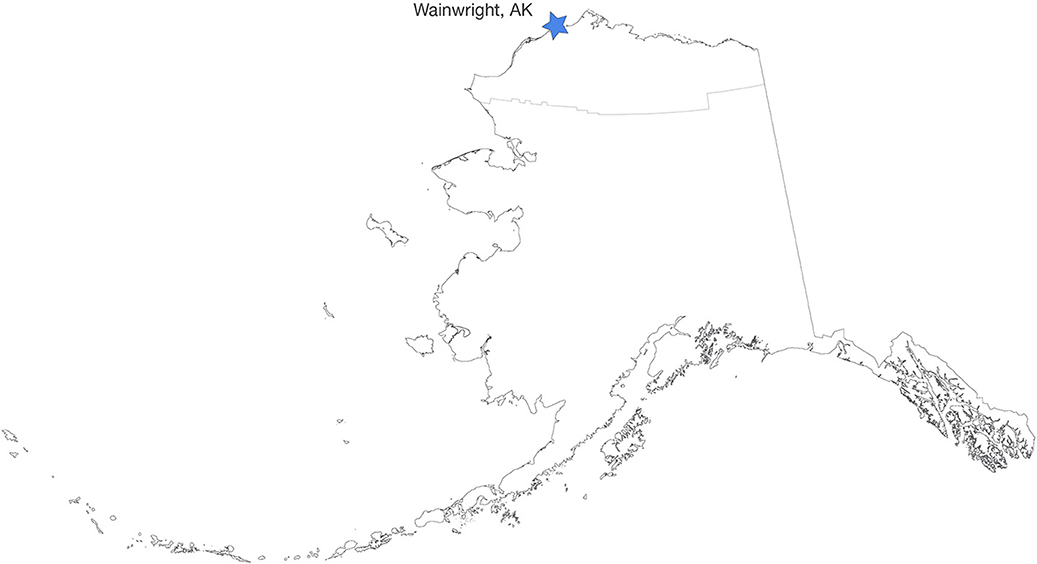
Figure 1. Wainwright, Alaska, and the North Slope Borough boundary line.
The Wainwright community has undergone significant changes throughout history. Today, while many features of the Western lifestyle pervade local culture, traditional values continue to play a central role in day-to-day life. The Iñupiat residents of Wainwright live a mixed cash and subsistence lifestyle that remains dependent on fishing, gathering, and hunting on land and in the ocean for physical and cultural nourishment (Village of Wainwright, 2016).
Like many of Alaska's North Slope communities, Wainwright is experiencing the effects of climate change. Seasonally reduced and thinning sea ice is causing shifting animal migratory patterns, eroding shorelines, and a number of other environmental changes (Brubaker et al., 2014). Uncertainty related to these changes is further compounded by the varied economic challenges and opportunities (e.g., arctic shipping, tourism, resource extraction) that create a complex dynamic for Wainwright decision-makers to address.
The Wainwright Study involved conducting semi-structured interviews with long-term Village of Wainwright residents (Denzin and Lincoln, 2011). Interviews focused on each participant's observations of change throughout their lifetime as well as family and community scale adaptations in response to unexpected events, environmental changes, economic development, and other factors. For additional details on participant selection, data collection, and analysis protocol please see Curry (2019).
The contextual analysis of interviews yielded rich information. The most endorsed, environmentally influenced challenges causing concern to participants included challenges related to whaling (e.g., timing of migration, thinning ice), and seasonal change (e.g., timing of seasons, late freeze-up/early break-up of ocean and rivers). Throughout the study, emergent themes and their operationalizations were presented back to the Wainwright Traditional Council. In addition to assessing the credibility of the findings, Wainwright partners discussed the importance of using visual images to help communicate research findings regarding environmental change. As described by Kress and Van Leeuwen (1996), it was proposed that the inclusion of Native artwork would provide images from a local perspective and outside the compositional structures of Western culture (Kress and Van Leeuwen, 1996).
Based on this supposition, funding was secured to create visual representations of major themes that emerged from the Wainwright Study. Context-rich images were developed via Native art, photographs, and photomontage. Through a solicitation process to commission artwork by a North Slope artist of Iñupiat heritage, the artist, George Leavitt of Utqiaġvik (name used with permission), drew inspiration from the Wainwright interview themes and direct quotes related to seasonal change, sea ice variability, and their impacts on hunting and transportation. Examples of Mr. Leavitt's work used in the project are shown in Figures 2, 3.
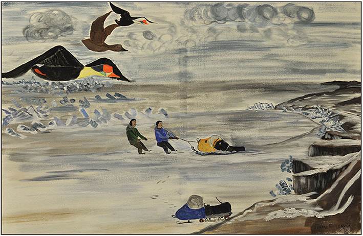
Figure 2. “Duck hunting in spring.” George Leavitt, 2017. Hunters must exercise caution when traveling along shore ice in the early spring. It is best to travel with a partner.
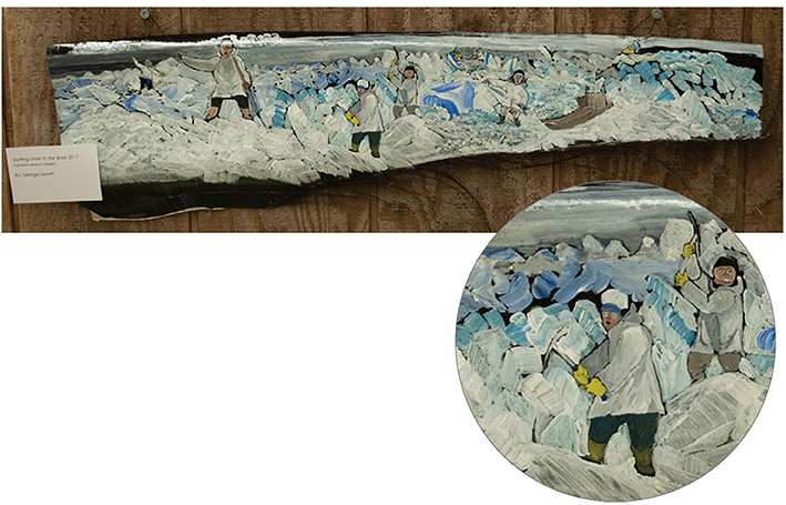
Figure 3. “Getting close to the lead,” painted scene on baleen. George Leavitt, 2017. Depicts lñupiat whalers breaking trail to open lead. Decreased sea ice leads to increased winds, which in turn push pressure ridges against village shorelines, making trail-breaking hard work.
Further, additional context-rich images were derived from photographs depicting Iñuit hunters and their relationship to sea ice. For example, the series of photographs below creates a narrative of the mobility of ice floes and attempts to illustrate the challenge presented to hunters by increasingly distant floes as a result of declining sea ice (Figure 4).
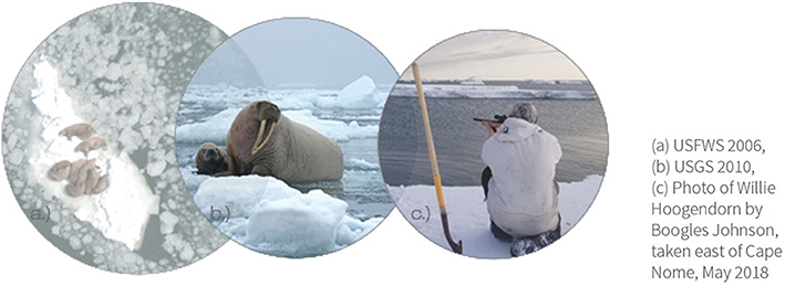
Figure 4. Sea ice coverage impact on walrus hunting. Walrus remain in the vicinity of coastal villages as long as there is pock ice nearby. This important food source is less accessible to hunters when ice floes ore for out to sea (a) USFWS 2006, (b) USGS 2010, (c) Photo of Willie Hoogendorn by Boogies Johnson, taken east of Cape Nome, May 2018.
Finally, photomontage images were developed to combine the abundant detail of a photograph, with the abstracted reality and descriptive function of a diagram. In Figure 5—The photograph shows the visible aboveground, and the diagram is an artificial depiction of the “invisible” sub-surface. The photograph in this case was chosen to convey scale and magnitude, including the enormous mass of a bowhead whale and the substantial number of people involved in the whaling process. The photo also serves to emphasize the relationship between people, whale, and sea ice. The diagrammed portion is intended to draw the reader's attention to the important dynamics below the sea ice surface, in particular the minimum thickness needed to sustain the whale's weight for a safe and successful harvest.
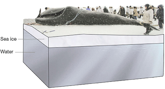
Figure 5. Sea ice thickness and whaling. A minimum 3–4 feet of ice thickness is needed to support the weight of a whole.
Images as Information Pilot Study
The Images as Information Pilot Study was developed to assess the benefits and limitations of context-rich images and multiple evidence based (MEB) reporting for conveying place-based information to public sector resource management practitioners. This involved the following: (1) conducting key informant interviews to develop the pilot study; (2) developing data collection materials, including three versions of issue briefs that varied in content (baseline, baseline + place-based quotes, and baseline + quotes + context-rich images); and (3) data collection with participants reviewing each report, indicating their preferences via an online questionnaire, and taking part in a follow-up semi-structured interview.
Key Informant Interviews to Develop the Pilot Study
Five key informants provided insights during interviews that lasted between 30 and 60 min. Participants included two senior-level wildlife scientists and one senior-level social scientist from federal agencies in Alaska, and two information/decision support specialists working for two Alaska-based boundary organizations. The goals of the key informant interviews were to answer the following questions: What is the conventional treatment of place-based information for decision-making within environmental management agencies? and What should be considered when choosing boundary objects that are useful to decision-makers?
Key informants discussed a generally recognized need for place-based information, including local and Indigenous knowledge, for planning and decision-making in Alaska. However, the extent to which practitioners actually utilize this information in their own work depends on their responsibilities. For example, inseason fishery managers are concerned with catch rates, the status of stocks, and species quotas within a particular season. Based on this information, they announce fishery openings/closures and may prohibit the retention of certain species to ensure the amount caught does not exceed the annual set limit. These decisions are often made “on the fly” with limited time for deliberation and consultation. As such, inseason managers work almost exclusively with quantitative data and see little need for place-based information. However, place-based information is believed to be more integral for post-season assessment, which attempts to understand the impacts of inseason management decisions on the fishery. Public meetings are held to obtain stakeholder feedback, which then becomes part of inseason policy for the next season.
While some tasks are inherently more quantitative than others, adherence to accepted information sources within an organization is seemingly also driven by bias. While inseason fishery managers may not consider place-based information beneficial for their work, there may be occasions where additional knowledge of context has an influence on the way data is interpreted. Conservatism (adhering to what is perceived to be “normal”) and complexity are the principal factors affecting the use of differentiated information sources (Rayner et al., 2005). Conservatism is reinforced by organizational reward structures that motivate practitioners to adhere to industry standards and procedures, making them resistant to experimentation with new approaches (ibid.). Similarly, complexity makes new information difficult to integrate into existing decision-making tools that are well-ingrained within the organizational culture (Rayner et al., 2005).
Place-based information is typically reported in agency documents using descriptive text and direct quotes from research participants. One key informant expressed frustration that many of her quantitative-minded colleagues were unwilling to engage information in this format or to accept it as reliable. While she assigned a high level of importance to data in the form of written quotes, others perceived it as anecdotal and untrustworthy. She reported having greater success summarizing the same information in table format. By adapting place-based information to quantitative representational techniques, the original data lost some richness but was able to reach more people. When asked for examples of visuals used to convey place-based information, all key informants cited familiarity with the use of photographs for this purpose. No other images types were referenced.
Additionally, key informants reported they did not typically see local and Indigenous knowledge presented alongside formal science. These distinct information sources were frequently included in different sections of the same report, but rarely together. For example, environmental assessments, conducted as part of the National Environmental Policy Act (NEPA) review process, typically separate the evaluation of the physical environment, the biological environment, and the social and economic environment into three distinct sections. Information sourced from local and Indigenous knowledge is generally organized into the social and economic section. In contrast, Ascher et al. (2010) suggest that the presentation of environmental information to decision-makers should avoid segregating knowledge based on different approaches to minimize the likelihood that decision-makers will ignore or neglect differentiated sources of information and the values it reflects (Ascher et al., 2010).
Key informants identified agency personnel of mid- to upper-level seniority as a target audience given individuals in these positions have broad job responsibilities that necessitate a wide range of information sources, and the authority to make decisions based on that information. Key informants noted that, due to time constraints, these administrators are more likely to rely on summarized information in tables, graphs, and charts, with text functioning as a secondary, albeit necessary, source of information. This was an indication that context-rich images could be particularly useful for those managers who lack sufficient time to engage with detailed place-based information.
Pilot Study Materials and Methods
Key informant insights were incorporated into the materials used in the Images as Information Pilot Study which included three versions of a two-page report on sea ice variability and its impact on hunting and transportation in coastal North Slope Alaska communities (see Figure 6). Report A (baseline) was designed to follow current norms with text that summarizes knowledge from the natural sciences, and conventional graphics (e.g., tables, graphs, charts, and maps). Report B (baseline + place-based text as quotes) was an MEB version of Report A with the addition of quotes from Wainwright residents (Curry, 2019). Report C (baseline + place-based text as quotes + place-based images) was a second MEB report containing the same information as B with the addition of context-rich images.
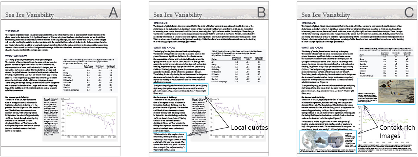
Figure 6. Sample reports (A–C).
Images developed based on themes from the Wainwright Study were selected for inclusion into the sample report materials based on their ability to provide useful information and assist in advancing the reader's interpretation. Additionally, the visuals had to be presentable, readable, and combinable with text in the format of an otherwise conventional report (Latour, 1986). These production decisions were made based key informant guidance regarding how a hypothetical recipient in the target audience (public sector resource management practitioners) would likely perceive the material. It was further informed by theories in social semiotics (Kress and Van Leeuwen, 1996). Additionally, the selection of visuals for this study was determined by other practical considerations such as the social (Curry, 2019) and natural science (various sources) research they were intended to augment, and a desire to include multimodal media for the sake of comparison.
Study participants were practitioners who possessed: (1) expertise in environmental policy, planning, and/or decision-making, and (2) decision-making influence within their agency or organization. Participants were identified based on recommendations from senior managers at Alaska state and national agencies/organizations involved in environmental management and research.
Participants were asked to complete an online questionnaire (see Supplementary Materials), which involved the sequential review of three versions of the two-page report and prompted responses to questions that focused on the following: Participant's background, perceptions of each report (A, B, C) in terms of overall credibility of information provided, and salience of the place-based quotes and context-rich images. Ultimately, participants were asked to choose which of the reports (A, B, C) they preferred given the intended purpose; “To provide an understanding of current knowledge on key components of sea ice variability on the North Slope of Alaska as well as an understanding of the local context and experience of these changes.” After completing the online questionnaire, participants had the option to also complete a semi-structured follow-up interview that encompassed five open-ended questions as well as probes to allow participants to clarify and elaborate on details provided in their initial questionnaire responses, and to provide constructive feedback regarding the Research Topic and study design. Follow-up interview questions and the rationale for their inclusion are provided in Table 1. Questionnaire data were analyzed using Microsoft Excel. Interviews were audio recorded (with permission), transcribed, then coded and analyzed by the lead author using NVivo (version 12) qualitative data analysis software. The following reports the results based on analysis of both the questionnaire and follow-up interviews.
Table 1. Follow-up interview questions and rationale.
Results
Eight practitioners from six public agencies participated in the online questionnaire, which took an average of 40 min to complete. Responses to background questions are reported in Table 2. On average, participants rated themselves good (4.1 out of 5) regarding their familiarity with environmental issues on the North Slope of Alaska and fair to good (3.6 out of 5) in terms of their familiarity with social issues in the region. Participants on average rated local and Indigenous knowledge as being high (4.5 out of 5) in terms of its value as an information source for environmental planning and decision-making. Respondents on average rated themselves neutral (3.25 out of 5) in terms of their learning preference (textual to visual). Six participants also completed a follow-up interview (30 min average) to further clarify their questionnaire responses, particularly with regard to the credibility, salience, and potential efficacy of MEB reports in practice.
Table 2. Questionnaire background question summary.
Credibility
Credibility refers to the perceived adequacy of the evidence and arguments presented. When asked their impressions of Report A (baseline), participants called the report “clearly written,” “straightforward,” “balanced,” “basic,” and “organized to be a quick read.” Participants were asked sequentially to rate the perceived change in credibility for each version of the report. The MEB documents [Report B [baseline + quotes] and Report C [baseline + quotes + images]] were perceived to be equally or more credible than the Report A (baseline). The results are summarized in Figure 7 and detailed further below.
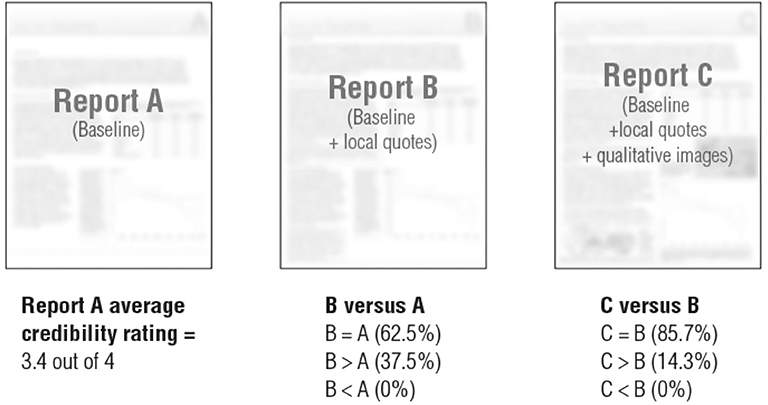
Figure 7. Report credibility comparison.
Report A (baseline) was rated on average as being relatively high (3.4 out of 4) for credibility (Figure 7). Open-ended questionnaire responses provided insight into participant ratings, which were based on the presence of citations from peer-reviewed literature, statistic trends, and the inclusion of information about gaps in current knowledge related to the topic.
Participants rated Report B (baseline + quotes) as either equally (62.5%) or more (37.5%) credible than Report A (baseline) (see Figure 7). One respondent noted:
“[Report B] would certainly be more credible to a wider audience, and adds human, on-the-ground verification of the scientific findings.” (Questionnaire participant #6)
While the inclusion of quotes may have increased perceived credibility, one participant was critical that there was not sufficient information to demonstrate the legitimacy of the quotes:
“I like report B better because it presents information about the social relevance of the issue. Because the information is in the form of individual quotes without evidence that the statements have been corroborated by others in the region, I hesitate to call it more ‘credible”’ (Questionnaire participant #1)
Participants rated Report C (baseline + quotes + context-rich images) as either equally (85.7%) or more (14.3%) credible than Report B (baseline + quotes). One respondent explained:
“For me, these particular images don't add or detract from the credibility, though they do add some really key perspective.” (Questionnaire participant #2)
Salience
Salience refers to the relevance of the evidence to the needs of decision-makers. Referring to the importance of place-based information for decision-making, one participant noted managers and policy-makers are concerned not only with scientific facts, but also with societal relevance, which the quotes and context-rich images provide. When asked to choose which, if any, of the reports (A, B, C) was preferred given the intended purpose (to provide an understanding of current knowledge as well as the local context and experience of Northern environmental changes), seven of the eight participants chose Report C. The remaining participant chose Report B. Participants' preference for the MEB documents is reflected by the following quotes:
“For the first part of the purpose, you only need report A and/or B. To meet the second part of the purpose (i.e., both context and experience), you must have report C” (Questionnaire participant #2)
“Sometimes there are measurable changes that don't impact communities. The quotes are really key in demonstrating that the documented changes are impactful. Not all off the pictures necessarily increase the credibility of the document or provide key information—some do—but they all provide visual context to the statements and quotes so that the reader can picture what is going on, even if they have not been to the North Slope.” (Questionnaire participant #1)
As the above quote suggests, some of the images were more successful than others at enriching the information in the report. Figure 5, the montage image illustrating the importance of sea ice thickness, was perceived to be the most successful. Its ability to place the trends of declining sea ice described by the report into a clear context was the primary beneficial quality cited.
“[The figure] reinforces the statement it's paired with quite well, and nicely draws the connections between the academic text and the quote” (Questionnaire participant #2).
The lowest rated image was Figure 2. The figure was characterized as not quite the appropriate image to describe sea ice formation and break-up trends that it was intended to support.
“I think the figure is slightly misleading, as it illustrates a landfast ice case, yet the report is about the pack ice. Ideally, figures would be consistent with the text” (Questionnaire participant #4).
Figure 2, while representative of quotes from Wainwright interviews, was not a perfect match for the specific content of the report. One respondent noted:
“… graphics are really helpful, but I think it just has to be the perfect one” (Follow-up interview #6)
MEB Reports and Context-Rich Images as Boundary Objects
The potential for MEB documents and context-rich images to function as boundary objects was evaluated based on criteria established by Leigh Star and Griesemer (1989) and Leigh Star (2010). By definition, boundary objects have (1) flexibility to adapt to differing information and work requirements, (2) sufficient robustness to maintain a common identity across sites, and (3) both general and specific applications that different groups working together or separately can move between.
Interpretive Flexibility
The MEB reports (Reports B and C) were a synthesis of findings from the natural sciences and from place-based research. Study participants noted the relevance of the information provided for both expert and non-expert audiences. One participant who self-identified as an expert on the science topics covered in the sample reports pointed to the benefit of illuminating the “human element” to audiences while dually gaining the reader's fascination:
“The inclusion of the photographs and artwork didn't affect my understanding, but I think they're a valuable addition because they add to the human element provided by the quotes, and they get the attention of the reader. This might be particularly important for the non-expert reader, who might be more encouraged to read more if the photographs and artwork act as an initial hook” (Questionnaire participant #5)
Additionally, participants also noted the potentially valuable role of MEB documents for alerting disciplinarily siloed practitioners to the importance of other types of information. According to one participant, many people at environmental management agencies that become decision-makers are from a natural science background and tend to be wired toward hard science. One of the advantages of reporting local and Indigenous knowledge together with Western science is that it reminds decision-makers about other important factors to consider (Follow-up interview participant #6). The same participant who was a Western-trained wildlife biologist singled out Figure 3, a painted scene on baleen (a keratin-based system inside the mouths of baleen whales used to filter food such as krill from the ocean) for its lack of interpretive flexibility (e.g., incongruity with her academic worldview). She described the image as “just too flowery” for the document and its intended audience (Follow-up interview participant #6).
Robustness
The robustness of the MEB documents was a function of the visual legibility of the report contents across multiple formats (e.g., print, web) and the fidelity of the information being reported across Reports A, B, and C. Prioritizing content given document length restrictions is a challenge in summary-style reports. One questionnaire respondent noted that, in practice, there are non-negotiable page limits and, often times, adding images means sacrificing allotted space for informative text, which would reduce credibility (questionnaire Respondent 1). In Report C, some legibility was unintentionally sacrificed for the ability to maintain a consistent amount of textual detail when context-rich images were added to the document. As questionnaire respondents noted, the scale of Figure 2 was too small to clearly make out the scene being depicted (two young men struggling with a snow machine that has broken through ice). This had a negative impact on the robustness of the report and limited the amount of information the figure itself was able to convey. Still, other participants highlighted some distinct advantages of using images in concise communication. One respondent mentioned the adage:
“A picture is worth 1,000 words, and there's a lot of truth in that… it takes a long time relatively to read 1,000 words vs. look at a picture” (Follow-up interview #5).
Other comments indicated that stronger image captions could help improve the robustness of context-rich images with the potential added benefit of expanding the quantity of information they are capable of transmitting. Information about the time period represented in the images and more explanation about the actions and relationships being depicted were examples cited in open-ended questionnaire responses.
In relation to the fidelity of the messages being conveyed in the report, the paintings seemed to add unintended noise. The paintings were divorced from this context when scaled down to fit a standard letter sized page. The inclusion of paintings was characterized by one participant as “distracting” because the reader then had to engage with and make value judgements about the art that were not related to the core message of the report. While an audience might ponder such things freely in an art gallery, the pages of the report were not considered the proper venue. The paintings led the participant to wonder if there was some other underlying message being conveyed with their inclusion, a perception that could mute the potential for these particular images to convey information for decision-making, and ultimately reduce the credibility of Report C. The same participant stated:
“I would say that the artwork [paintings], makes the report less credible, while the other photos/graphics add to one's understanding.” (questionnaire participant #6)
General and Specific Application
Interpretive flexibility enables the specific application of MEB documents and context-rich images while their general application is determined by their usability in collaborations or negotiations between groups. Focusing on the dissemination of knowledge for decision-making, the reported study did not examine their active use as boundary objects at the interface between diverse groups. However, participant comments provided insight into a potential general application. One participant noted that effective techniques for integrating Western science and place-based information such as MEB reporting would be useful for both internal and external agency communications. For example, internal briefing papers about the Arctic could be sent to people in headquarters offices in Washington D.C. who are far removed from changes on the North Slope. This group is likely to understand the value of local and Indigenous knowledge more if its contribution of context to Western science is made more visible. Concurrently, in the interest of transparency, agencies must demonstrate how they are using the local and Indigenous knowledge they collect. Formatting techniques that appeal to broad audiences can illustrate how agencies are integrating these knowledge sources in their work (Follow-up interview #4).
Discussion
The reported pilot study was undertaken to address deficiencies in current reporting conventions that can impede the translation of place-based information like local and Indigenous knowledge across disciplinary boundaries. The reported research utilized MEB assessment as a boundary work scenario where knowledge from multiple communities of expertise was assembled into a report with the intent of providing a holistic understanding of the reported issues for public agency decision-makers. The sample reports and the context-rich images within them were evaluated based on their ability to function as boundary objects that facilitate the transmission of information to decision-makers. Additional criteria for the evaluation of these objects was derived from the work of Clark et al. (2016) who highlighted credibility and salience as key factors influencing the usefulness of knowledge in scenarios similar to MEB assessment.
The integration of context-rich images into MEB documents may be considered unconventional. As such, for new approaches to become adopted as standards, it is necessary they be congruent with existing conventions that are already well-accepted (Rayner et al., 2005). Pilot study participants rated the MEB documents equally or more credible than Report A (baseline). This finding implies the MEB approach to reporting information to public agency decision-makers had no adverse impact on the reception of that information among study participants, and adds support to increased application of MEB approaches in practice. Where current conventions often separate place-based information and formal science into different sections of the same report, MEB documents are an alternative approach to present other relevant knowledge sources on equal footing with Western science, thereby minimizing the likelihood that decision-makers will neglect or ignore it (Ascher et al., 2010).
The reception of context-rich images among study participants was mixed. Report C (baseline + quotes + context-rich images) was rated as equally or more credible than Report B (baseline + quotes). Where Kress and Van Leeuwen (1996) posited that scientifically trained audiences are likely to ascribe greater truth to abstracted images of generalizable scientific information, our findings reveal that the same audience may also find context-rich images to be trustworthy. Non-positive comments related to the credibility of context-rich images focused on the paintings in particular (Figures 2, 3). The paintings were included in the sample report as Native artwork that could potentially convey local information or experience in an authentic way that was outside of the compositional structures of Western culture. While the paintings may have excelled in transmitting experiential information, they also shifted the tone of the document to a degree that caused one participant to question the objectivity of the information being presented. While this finding does not altogether negate the potential benefit of paintings and other similar context-rich images as boundary objects, it is an indication of a potential threshold denoting the bounds of acceptable information for this particular target audience.
Salience was a key factor determining the potential usefulness of the MEB documents and context-rich images for decision-making. Participant comments indicated that the integration of local quotes in Report B (baseline + quotes) provided additional useful information that was not included in Report A (baseline) such as evidence that the statistically detectible environmental changes summarized in the report are significant enough to have a perceptible impact on local people. Phenomena that are detectable in the data are not always perceptible to humans, yet the quotes provide an indication that observed changes are having an appreciable impact on people's lives. Participants also commented that both the images and the quotes were beneficial because they show the societal relevance of the science and help readers understand what environmental conditions mean to people who live and work in the Arctic. Additionally, positive comments indicated that the sample context-rich images were a useful tool that aided quotes in the explanation of local context and experience of Northern environmental changes to outside audiences. This benefit might be particularly helpful for readers who are visual learners (Felder and Silverman, 1988).
Some participant comments indicated that particular context-rich images were not successful at providing additional useful information. The strength of the association between the figure and the information it was paired with was key in this respect, highlighting a major concern for the selection and application of context-rich images in MEB reporting. Technical documents are largely composed with verbal text in mind (Salinas, 2002). This means that visual design is restricted to the coordination of visuals as secondary to text in layout and document design (ibid.). An alternative approach might consider the larger cultural impact of images, which are primary to how we read and communicate today, particularly in the realm of electronic media (Salinas, 2002). However, the ability of images to take a primary role as drivers of content in this study was limited by the lack of high resolution scientific observations available for the Arctic region, especially in the near-shore environment, which is the area most relied-upon by local people (Carmack et al., 2015). The lack of high resolution data available via remote sensing has been identified as a challenge for local scale planning and decision-making in relation to Arctic environmental change (Vargas-Moreno et al., 2016).
A similar challenge in place-based research stems from the difficulty of acquiring images that adequately and precisely communicate place-based research findings (e.g., the social context within which the results occur) after data collection activities have concluded. However, the fields of anthropology and sociology offer the complementary photo-elicitation method, which is likely to provide benefits both in relation to the above challenge and toward the generation of rich discussion during research interviews. Simply described, photo-elicitation involves inserting a photograph (or other visual) into an interview, which has the effect of stimulating participants and evoking responses unlikely to be obtained otherwise (Harper, 2002). In photo-elicitation, research participants themselves may be asked to provide an image for discussion, which ultimately satisfies a dual purpose of both promoting discussion and helping the researcher collect context-rich images through which study findings can be more precisely communicated.
The perceived legitimacy of the MEB documents and context-rich images is also an important concern. The question of who gets to decide what information is relevant and how it should be presented to decision-makers is indicative of the level of agency afforded to local and Indigenous people in decision-making processes. This reported pilot research contributes to the development of communication approaches intended to strengthen local agency by increasing the prominence and accessibility of local and Indigenous knowledge among information used by decision-makers. The place-based information and context-rich images included in the sample reports were verified by local Indigenous advisors from the Wainwright Study (Curry, 2019). However, local advisors were not involved in the curation of information that resulted in the final sample reports for this pilot study. The Western researchers who produced the original technical data included in the sample reports were also not consulted in the curation of the reported information. This process is reflective of how research is often synthesized for decision-makers in practice where the breadth of available information goes through levels of screening and framing before it makes its way to senior administrators (Ascher et al., 2010) who have many decisions to make within a limited timeframe. Those responsible for screening and framing activities might be knowledgeable experts or they might be entry-level personnel. In either case, there is potential for bias to unintentionally guide the selection and interpretation of information. A likely means of reducing such bias and improving the legitimacy of MEB sample reports and context-rich images is by validating the synthesized product with relevant experts such as the Indigenous knowledge holders and Western researchers from whom the information was sourced (Shenton, 2004).
Conclusion
The Images as Information Pilot study furthers the proposed methodology designed to evaluate an MEB reporting approach that integrates quantitative environmental research and place-based research. The pilot study findings indicate that context-rich images might improve communication of place-based information beyond the potential of basic text (e.g., quotes, narrative), which has beneficial applications for environmental decision-making and for place-based research in general. Furthermore, an MEB approach to reporting information from two separate knowledge systems may have no adverse impact on the reception of that information, and could offer a means to present alternative knowledge sources on equal footing with Western science. This is a necessary consideration given the persistence of organizational norms and disciplinary conventions that privilege quantitative Western science over other sources of information (Rayner et al., 2005; Martin, 2007; Lemos, 2008).
Overall, this pilot study supports the validity of the reported methodology for the evaluation of visual tools and reporting formats intended to addresses a need for proven methods of knowledge brokering and communication that facilitate the transmission of place-based knowledge for decision-making (Lemos, 2015). The two-phase mixed methods approach, informed by key informant interviews, applied the strengths of questionnaire and interview data enabling not only the identification of patterns across participants, but also the verification of findings and the collection of rich information (Shenton, 2004). Given its small sample size, the results of the pilot study cannot be generalized. Still, it is a point of departure for future research, which is significant given the persistent challenge of interfacing underrepresented knowledge sources in environmental governance efforts (Raymond-Yakoubian et al., 2017). Further research is necessary to determine if the anticipated benefits of the tested MEB techniques are realized in practice, especially considering the potentially diverse range of topics and organizational settings in which they might be applied. An ideal setting for the next iteration of this research would be in collaboration with ongoing reporting initiatives within environmental resource management agencies, particularly involving communication between local/regional offices and their counterparts in state/national headquarters that are far removed from the local impact of environmental changes. Such experiments in communication can be relatively low-cost and would provide valuable insight about the effectiveness of new techniques aiming to increase the usability of underrepresented knowledge sources in environmental governance.
Data Availability Statement
The datasets generated for this study are available on request to the corresponding author. Information may be withheld pursuant to the terms of the Wainwright Study and Pilot Study informed consent agreements.
Ethics Statement
This study was conducted in accordance with the recommendations of the Institutional Review Board (IRB) of the University of Alaska Fairbanks (IRB approval numbers: 767319-5 and 1343902-1).
Author Contributions
TC and EL made substantial contributions to the conception and design of the work, approved the final version to be published, and agreed to be accountable for all aspects of the work in ensuring that questions related to the accuracy or integrity of any part of the work are appropriately investigated and resolved. TC and EL were involved in the analysis and interpretation of data for the work. TC drafted the work and EL revised it critically for important intellectual content. All authors contributed to the article and approved the submitted version.
Funding
This research was based on work supported by the National Science Foundation under Grant No. 1342979, by the National Science Foundation under award #OIA-1208927 and by the State of Alaska, and also by the Cooperative Institute for Alaska Research with funds from the National Oceanic and Atmospheric Administration under cooperative agreement NA13OAR4320056 with the University of Alaska. Additional financial support was provided by the University of Alaska Fairbanks Resilience and Adaptation Program, the Department of Natural Resources and Environment, and the Sitka Sound Science Center.
Conflict of Interest
The authors declare that the research was conducted in the absence of any commercial or financial relationships that could be construed as a potential conflict of interest.
Supplementary Material
The Supplementary Material for this article can be found online at: https://www.frontiersin.org/articles/10.3389/fcomm.2020.00043/full#supplementary-material
References
Adger, W. N., Dessai, S., Goulden, M., Hulme, M., Lorenzoni, I., Nelson, D. R., et al. (2009). Are there social limits to adaptation to climate change? Clim. Change 93, 335–354. doi: 10.1007/s10584-008-9520-z
Ascher, W., Toddi, S., and Robert, H. (2010). Knowledge and Environmental Policy: Re-Imagining the Boundaries of Science and Politics. Cambridge, MA: The MIT Press. doi: 10.7551/mitpress/8398.001.0001
Berkes, F. (2012). Sacred Ecology: Traditional Ecological Knowledge and Resource Management. 3rd Edn. Philadelphia, PA: Taylor and Francis. doi: 10.4324/9780203123843
Brubaker, M., Jacob, B., Heather, D., Ronnie, M., Cheryl, T., Drake, R., et al. (2014). Climate Change in Wainwright, Alaska: Strategies for Community Health. Alaska Native Tribal Health Consortium, Center for Climate and Health.
Carmack, E., Peter, W., and William, W. (2015). The contiguous panarctic riverine coastal domain: a unifying concept. Prog. Oceanogr. 139:13–23. doi: 10.1016/j.pocean.2015.07.014
Cash, D. W., William, C., Frank, C. A., Nancy, M., Noelle, D. E., David, H., Jill Jäger, G., et al. (2003). Knowledge systems for sustainable development. Proc. Natl. Acad. Sci. U.S.A. 100, 8086–8091. doi: 10.1073/pnas.1231332100
Chaffin, B. C., Gosnell, H., and Cosens, B. A. (2014). A decade of adaptive governance scholarship: synthesis and future directions. Ecol. Soc. 19:56. doi: 10.5751/ES-06824-190356
Clark, W C., Tomich, T. P., van Noordwijk, M., Guston, D., Catacutan, D., and Dickson, N. M. (2016). Boundary work for sustainable development: Natural resource management at the Consultative Group on International Agricultural Research (CGIAR). Proc. Natl Acad. Sci. U.S.A. 113, 4615–4622. doi: 10.1073/pnas.0900231108
Curry, T. (2019). Learning from the local scale: identifying and addressing local blind spots in arctic environmental governance. (Ph.D. dissertation), Department of Natural Resources and Environment, University of Alaska Fairbanks.
Department of Labor. (2018). Alaska Population Estimates by Borough, Census Area, City, and Census Designated Place (CDP), 2010-2014. State of Alaska, Department of Labor and Workforce Analysis.
Dietz, T., Ostrom, E., and Stern, P. C. (2003). The struggle to govern the commons. science 302, 1907–1912. doi: 10.1126/science.1091015
Eden, S., Andrew, D., and Gordon, W. (2006). Green groups and grey areas: scientific boundary-work, nongovernmental organisations, and environmental knowledge. Environ. Plan. A 38, 1061–1076. doi: 10.1068/a37287
Eira, I. M. G., Jaedicke, C., Magga, O. H., Maynard, N. G., Vikhamar-Schuler, D., and Mathiesen, S. D. (2013). Traditional Sámi snow terminology and physical snow classification—Two ways of knowing. Cold Regions Sci. Technol. 85, 117–130. doi: 10.1016/j.coldregions.2012.09.004
Felder, R. M., and Silverman, L. K. (1988). “Learning and teaching styles in engineering education,” Engr. Educ. 78, 674–681.
Folke, C., Hahn, T., Olsson, P., and Norberg, J. (2005). Adaptive governance of social-ecological systems. Annu. Rev. Environ. Resour. 30, 441–473. doi: 10.1146/annurev.energy.30.050504.144511
Greene, J. C. (2007). Mixed methods in social inquiry. Vol. 9. San Francisco, CA: John Wiley & Sons.
Harper, D. (2002). Talking about pictures: a case for photo elicitation. Vis. Stud. 17, 13–26. doi: 10.1080/14725860220137345
Kress, G. R., and Van Leeuwen, T. (1996). Reading Images: The Grammar of Visual Design. New York, NY: Routledge Press.
Latour, B. (1999). Pandora's Hope: Essays on the Reality of Science Studies. Harvard University Press.
Leigh Star, S. (2010). This is not a boundary object: reflections on the origin of a concept. Sci. Technol. Hum. Values 35, 601–617. doi: 10.1177/0162243910377624
Leigh Star, S., and Griesemer, J. R. (1989). Institutional ecology,translations' and boundary objects: amateurs and professionals in berkeley's museum of vertebrate zoology, 1907-39. Social Stud. Sci. 19, 387–420. doi: 10.1177/030631289019003001
Lemos, M. C. (2008). “Whose water is it anyway,” in Water, Place, and Equity eds J. M. Whiteley, H. M. Ingram and R. Perry (Cambridge, MA: MIT Press), 249–270. doi: 10.7551/mitpress/9780262232715.003.0009
Lemos, M. C. (2015). Usable climate knowledge for adaptive and co-managed water governance. Curr. Opin. Environ. Sustain. 12, 48–52. doi: 10.1016/j.cosust.2014.09.005
Livingstone, S. (1998). Relationships between media and audiences: Prospects for future audience reception studies. in Media, Ritual and Identity: Essays in Honor of Elihu Katz, eds T. Liebes and J. Curran (London: Routledge).
Lurie, N. H., and Mason, C. H. (2007). Visual representation: implications for decision making. J. Market. 71, 160–177. doi: 10.1509/jmkg.71.1.160
Martin, T. (2007). Muting the voice of the local in the age of the global: how communication practices compromised public participation in India's Allain Dunhangan environmental impact assessment. Environ. Commun. 1, 171–193. doi: 10.1080/17524030701642595
McGreavy, B., Hutchins, K., Smith, H., Lindenfeld, L., and Silka, L. (2013). Addressing the complexities of boundary work in sustainability science through communication. Sustainability 5, 4195–4221. doi: 10.3390/su5104195
Meadows, D. H., and Wright, D. (2008). Thinking in Systems: A Primer. White River Junction, VT: Chelsea Green publishing.
Meyer, J., Shamo, M. K., and Gopher, D. (1999). Information structure and the relative efficacy of tables and graphs. Hum. Fact. 41, 570–587. doi: 10.1518/001872099779656707
Meyer, R., Höllerer, M., Jancsary, D., and Van Leeuwen, T. (2013). The visual dimension in organizing, organization, and organization research: core ideas, current developments, and promising avenues. Acad. Manag. Ann. 7, 489–555. doi: 10.5465/19416520.2013.781867
Nelson, D. R., Neil Adger, W., and Brown, K. (2007). Adaptation to environmental change: contributions of a resilience framework. Ann. Rev. Environ. Resour. 32, 395–419. doi: 10.1146/annurev.energy.32.051807.090348
Pahl-Wostl, C. (2009). A conceptual framework for analysing adaptive capacity and multi-level learning processes in resource governance regimes. Glob. Environ. Change 19, 354–365. doi: 10.1016/j.gloenvcha.2009.06.001
Raymond-Yakoubian, J., Raymond-Yakoubian, B., and Moncrieff, C. (2017). The incorporation of traditional knowledge into Alaska federal fisheries management. Marine Policy 78:132–142. doi: 10.1016/j.marpol.2016.12.024
Rayner, S., Lach, D., and Ingram, H. (2005). Weather forecasts are for wimps: why water resource managers do not use climate forecasts. Clim. Change 69, 197–227. doi: 10.1007/s10584-005-3148-z
Salinas, C. (2002). Technical rhetoricians and the art of configuring images. Tech. Commun. Quart. 11, 165–183. doi: 10.1207/s15427625tcq1102_4
Shenton, A. K. (2004). Strategies for ensuring trustworthiness in qualitative research projects. Educ. Inform. 22, 63–75. doi: 10.3233/EFI-2004-22201
Swedberg, R. (2018). How to use max weber's ideal type in sociological analysis. J. Class. Sociol. 18, 181–196. doi: 10.1177/1468795X17743643
Tengö, M., Brondizio, E. S., Elmqvist, T., Malmer, P., and Spierenburg, M. (2014). Connecting diverse knowledge systems for enhanced ecosystem governance: the multiple evidence base approach. Ambio 43, 579–591. doi: 10.1007/s13280-014-0501-3
Trainor, S., Larisa Abruitina, F., Chapin, S III., Chaschin, V., Cunsolo, A., Driscoll, D., et al. (2017). “Ch. 7 Adaptation,” in Adaptation Actions for a Changing Arctic: Perspectives from the Bering-Chukchi-Beaufort Region [Oslo: Arctic Monitoring and Assessment Programme (AMAP)]. 177–216.
Ulin, P. R., Robinson, E. T., and Tolley, E. E., (eds.). (2005). “The language and logic of qualitative research,” in Qualitative Methods in Public Health (San Francisco, CA: Jossey-Bass), 11–32.
Van Leeuwen, T. (2011). “The semiotics of decoration,” in Multimodal Studies: Exploring Issues and Domains, eds K. L. O'Halloran and B.A. Smith (London: Routledge). 115–131.
Van Wyk, E., Roux, D. J., Drackner, M., and McCool, S. F. (2008). The impact of scientific information on ecosystem management: making sense of the contextual gap between information providers and decision makers. Environ. Manag. 41, 779–791. doi: 10.1007/s00267-008-9084-8
Vargas-Moreno, J. C., Fradkin, B., Emperador, S., and Lee, O. A. (2016). Prioritizing Science Needs Through Participatory Scenarios for Energy and Resource Development on the North Slope and Adjacent Seas. Boston, MA: GEOAdaptive, LLC.
Village of Wainwright (2016). Wainwright Community Guide. Wainwright, AK: Village of Wainwright. Retrieved from http://nebula.wsimg.com/3b3c1a27515d05b03fddade732ec3cea?AccessKeyId=7CA4BFDA39E6ACF95364&disposition=0&alloworigin=1 (accessed June 24, 2020).
Keywords: boundary objects, communication, context-rich images, decision-making, governance, information, local knowledge, social-ecological systems
Citation: Curry T and Lopez EDS (2020) Images as Information: Context-Rich Images and the Communication of Place-Based Information Through Increased Representation in Environmental Governance. Front. Commun. 5:43. doi: 10.3389/fcomm.2020.00043
Received: 13 August 2019; Accepted: 02 June 2020;
Published: 09 July 2020.
Edited by:
Thomas Hayden, Stanford University, United StatesReviewed by:
Samantha Senda-Cook, Creighton University, United StatesJen Schneider, Boise State University, United States
Copyright © 2020 Curry and Lopez. This is an open-access article distributed under the terms of the Creative Commons Attribution License (CC BY). The use, distribution or reproduction in other forums is permitted, provided the original author(s) and the copyright owner(s) are credited and that the original publication in this journal is cited, in accordance with accepted academic practice. No use, distribution or reproduction is permitted which does not comply with these terms.
*Correspondence: Tracie Curry, dHJhY2llLmN1cnJ5QGFsYXNrYS5lZHU=