 Jennifer A. Strauss*
 Qingkai Kong
 Sharon Pothan
 Stephen Thompson
 Ramon F. Mejia
 Steven Allen
 Sarina Patel
 Richard M. Allen
- Berkeley Seismology Lab, University of California, Berkeley, Berkeley, CA, United States
The MyShake app began delivering earthquake early warning alerts to users in California on October 17, 2019. The app delivers alerts from ShakeAlert when the estimated magnitude is 4.5 or greater to phones in the Modified Mercalli Intensity (MMI) III or greater zone. MyShake users receive the alerts, but also serve as citizen seismologists for the system. They contribute accelerometer data allowing this dual-use network to serve as an alert delivery platform and an earthquake monitoring network. Users are also now afforded the ability to interactively share their experience in an earthquake with others on the system through the use of an experience report. The design and maintenance of this system requires the interoperability of many technical systems (servers, code, smartphones) and stakeholders (scientists, federal and state agencies, public). This imparts some constraints on our ability to address problems and implement new features, but ultimately provides a considered framework within which we can design for future use cases. We discuss new features of the app, such as the experience report, the collection of timing information to improve delivery latencies, and examples of how human centered design responds to user needs. We also look at privacy constraints and ways MyShake can continue to improve in the future.
Introduction
The MyShake™ Global smartphone network works at the intersection of science, community, and public safety with a goal of building an international platform that can benefit communities in earthquake prone regions (Allen et al., 2019). MyShake scientists collect both real-time earthquake triggers from the accelerometers in phones as well as the off-line waveform data recordings near active earthquakes to better understand some problems in seismology and engineering, such as earthquake early warning (Kong et al., 2016a), routine seismic network operations (Kong et al., 2016b, 2019b), array processing (Inbal et al., 2019), and structural health monitoring (Kong et al., 2018). This community not only interacts with the scientists by providing data, but can also interact with each other through the reporting features in the app to improve post-quake awareness in their neighborhood. MyShake uses the platform to provide educational safety information about what to do before, during and after a quake. Furthering this commitment to safety, MyShake is also now delivering earthquake ShakeAlerts™ (Given et al., 2018) to phones in the area of shaking in California, USA.
Many earthquake smartphone applications are available on the Google Play and Apple App stores today. Some, like the apps from American Red Cross and Earthquakes Tracker (https://www.redcross.org/get-help/how-to-prepare-for-emergencies/mobile-apps.html, https://play.google.com/store/apps/details?id=com.rsoftr.android.earthquakestracker.add), provide information on recent earthquakes. Others, like LastQuake1 (Bossu et al., 2018) and Earthquake Network2 (Finazzi, 2016), go a step further to collect crowdsourcing evidence reports and sensor triggers and deliver fast notifications to people in the areas affected by an earthquake shaking. MyShake is unique in this space in the way that it combines information from global earthquake catalogs, earthquake early warning (EEW) alerts from traditional seismic networks, an on-board artificial neural network (Kong et al., 2019a) to provide phone-derived alerts (in testing), as well as reports from local users on road and building conditions.
There are additional related efforts using the power of crowdsourcing to detect and evaluate earthquakes, such as the Taiwan Scientific Earthquake Reporting System, which crowdsources reports from volunteers on damage after an earthquake (Liang et al., 2019); Did You Feel It (DYFI; Wald et al., 1999), which compiles online surveys after earthquakes to evaluate the felt shaking intensity at various places; P-Alert, Community Seismic Network (CSN), QuakeCatcher network, Raspberry Shake, etc. which all use low-cost sensors to detect earthquakes (Chung et al., 2011; Clayton et al., 2015; Jan et al., 2018; Anthony et al., 2019), and finally, using Tweets as social sensors to detect the occurrences of an earthquake (Earle, 2010; Sakaki et al., 2010).
Innovations in this space will be crucial as more countries adopt the technology publicly. MyShake is working with stakeholders in the scientific, government, and local communities to determine the best most actionable ways to provide alerts to the people who need it most. We also probe what could be done in the sphere of public communication to improve earthquake knowledge and safety for the affected communities. Experience reports on the MyShake app were created using a human-centered design process to make them informative public communication tools and simple to use (Rochford et al., 2018). Rochford et al. (2018) outlined the purpose and process for the design of the reports, but as the iOS version was only available after the redesign was complete, we can here examine how the reports are being used by the community and the iOS version serves as a good control group for assessing the impact of design improvements. Timing information data was incorporated into the app and backend servers to see how quickly people are actually getting earthquake alerts. For alerts, speed of alert delivery is a critical part of the public communication and being able to measure this accurately will improve delivery speeds. The overarching goal of MyShake's design process is to avoid simply pushing information to people, but the acknowledgment that the users are citizen scientists as well and have their own experience and information to contribute. This synergy between science, community, and safety allows us to figure out what people do want in terms of information and balance that with the needs of the scientific community.
Context
The people of California, USA have been waiting on EEW to become a public reality for many years. Since 2006, a group of scientists from Universities on the West Coast and the United States Geological Survey have been developing the technology to provide earthquake early warning alerts using traditional seismic technology—much like is done in other countries like Mexico and Japan (Aranda et al., 1995; Kamigaichi, 2004; Allen and Melgar, 2019). This system, called ShakeAlert™ (Given et al., 2018), has developed over the years from a demonstration product (in 2012), to piloting automated controls (in 2016), and finally as a way to provide alerts that can be redistributed to the public (in 2019).
The Berkeley Seismology Lab took the lead in developing a proof of concept smartphone application to demonstrate the possibility of providing public alerts through this pathway. The app was called MyEEW and was tested with a small group of ShakeAlert stakeholders beginning in 2015. A short film containing a vignette of a teacher receiving the alert and taking action to protect the school kids in her care became an impactful vision of how EEW could work in real-world applications. Later, UC Berkeley merged the alerting technology of MyEEW with the citizen science initiative of their MyShake app to create a single app, which could serve both communities.
MyShake remained in testing mode with just a small number of users receiving alerts until the emergency management community and other stakeholders were comfortable with more wide-spread public alerting. The lessons learned from the North Bay California fires in 2017 and 2018, made it clear that providing information to people can be critical in a disaster so they can act accordingly. The affected community called for more information about the fires in real time; people wanted information as quickly and as accurately as they could get it. Mirroring that need from wildfire emergencies to a future need after a damaging earthquake, it became clear that the time to transition from internal testing to external prototyping had come. Berkeley Seismology Lab, in partnership with the California Office of Emergency Services and the Governor's office of California, worked with the United States Geological Survey and the rest of ShakeAlert team to make the public pilot of MyShake possible.
The MyShake app EEW capability was rolled out publicly by an announcement from Gov. Gavin Newsom on the 30th anniversary of the Loma Prieta earthquake, October 17, 2019 (Figure 1). Within 2 months, more than 600,000 user downloads proved the desire for EEW in California. ShakeAlert messages are sent automatically to MyShake servers, which send the information to phones running the MyShake app. For this prototype phase, alerts are sent for earthquakes estimated to be >M4.5 to phones in the MMI III or greater shaking area (light shaking). The alerts contain built-in safety and preparedness information. The audio alert states: Earthquake, drop, cover, hold-on shaking expected (Figure 2). Text on the alert card provides the same information as the audio alert and additionally includes the estimated magnitude, time of the event, and a reminder that the alert is provided by ShakeAlert. Visually the app reminds users what to do when they receive an alert using Earthquake Country Alliance's Drop, Cover, Hold-On triptych (image Courtesy Earthquake Country Alliance3). Clicking on the link, takes users to the map where a bulls-eye icon displays the preliminary location for the event. As more information becomes available from the official USGS earthquake catalog, an event will appear on the map and users will be able to click to read more about the event and share their experience. In the case of a false alert, any follow-up information about the false alert provided by ShakeAlert will be forwarded to users who were initially alerted. The bulls-eye on the map will also disappear with no earthquake information appearing in its place.
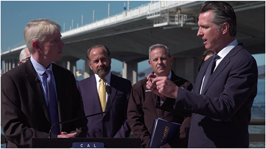
Figure 1. On October 17, 2019, stakeholders gathered at a special event where Governor Gavin Newsom announced the launch of MyShake as the official EEW app for California. From left to right are Director Richard Allen (UC Berkeley), State Senator Jerry Hill, Director Mark Ghilarducci (CalOES), and Governor Newsom.
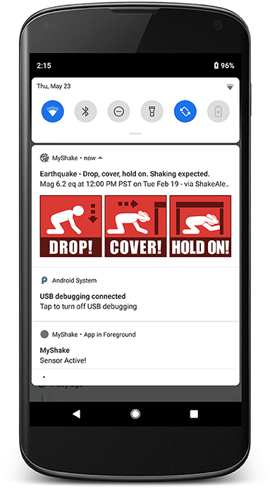
Figure 2. The EEW notification appears on a phone providing information on the nearby earthquake and what the user should do.
In addition to sending/receiving ShakeAlert messages, MyShake phones also have the capability to detect earthquake shaking using the accelerometer in all smartphones. When stationary, phones run an on-board artificial neural network that is trained to determine if shaking is earthquake-like or not. If the determination is yes, a real-time message is sent back to the cloud server with location, time and amplitude of the shaking, where a spatial and temporal clustering algorithm will confirm the occurrence of the earthquake. Meanwhile, the phones record the accelerations in three components observed by the accelerometer sensor during the earthquake and automatically send those seismic recordings to scientists when the phones connected to power and WiFi (Kong et al., 2019a). This enables MyShake scientists to collect data from a very dense smartphone seismic network in areas where people are located. An analysis of the use of accelerometers inside the phones to characterize seismic data is beyond the scope of this paper, but has been reported in previous papers. Interested readers can read the more recent development (Kong et al., 2019a,b).
Detail to Understand Key Programmatic Elements
We are using the smartphone app to innovate on how people engage with earthquakes. Many current options for earthquake information transfer, or collection of seismic data using smartphones are in essence one-way streets. Information is pushed and data is collected. The user is rendered a passive part of the equation. One notable exception is the Did You Feel It (DYFI) survey, which “provides a two-way flow of post-earthquake information” (Wald et al., 2011). A one-way flow of information used to be true for map and driving applications, but the past decade has seen innovation in that area as well and we now get traffic conditions, can report accidents, and have a give-and take-relationship with our daily commute (waze, google maps, mapquest, apple maps). The MyShake team has a goal to improve the familiarity and awareness of our community of users through engagement with the app.
Public involvement is important to help tailor provided information to reflect what the populous seeks to learn. Feedback from users also allows the project to hone in on awareness and misconceptions the public may have about seismic impact, seismic safety best practices, and how to better prepare before an event. We maintain a website, twitter account, and monitor email, google play store, and apple app store replies and requests to collect feedback. Through an iterative recording, coding, and evaluation process, key themes are highlighted. From there, we can improve on the app itself, or how we communicate the information in the app to align it more with expectations, needs, and correct science. One of the ways to engage the participation of users is the Experience Report.
An Experience Report is an interactive experience in the app that allows people to report on their observations after the quake through a simple to use interface. The first aspect of the report regards shaking intensity. Users are asked to report the level of shaking they experienced using a series of graded images and descriptions. This questionnaire is a simplified version of the USGS Did You Feel It (DYFI) assessment, and has a different objective. DYFI walks respondents through a very detailed questionnaire to probe as closely as possible the Modified Mercalli Intensity (MMI) value at their location. This allows DYFI, in part, to correlate DYFI responses to instrument data and fill in missing data (Worden et al., 2018). MyShake, in contrast, is focused on providing general information about nearby shaking to the users, so they can be informed about their neighborhood, and thus does not need such scientific precision. Both MyShake and DYFI have a goal of information sharing and a sense of community, but our single purpose of community allows us to simplify the process. The second aspect of the experience report is the ability to report on local building, bridge, and road damage. Directly after a quake it may not be clear which areas were hardest hit and the best ways to get around a user's area. By crowdsourcing this information and linking it with the experience of others, we aim to provide users with quick general information that they can use right in the moment.
One recent example is from the M6.4 Indios earthquake which occurred on January 7th, 2020 on the Southern Coast of Puerto Rico (USGS event id us70006vll). Users began immediately filling out their Experience Reports, suggesting that the app may be a convenient way of reporting right in the moment. Figure 3 shows snapshots of the earthquake page for this quake. The purple and orange hexbins on the map are aggregate reports from users about damage intensity color coded by severity (with orange being higher damage). Below the map are tables and infographics that break the data down in more easily digestible chunks. One hundred fifty-three people submitted experience reports for the event throughout the island. Reported road and building damage was highest near the epicenter. Users in other areas continue to fill out Experience Reports after felt events. From this continued engagement, we can surmise that this added feature was well received by the user community.
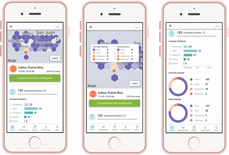
Figure 3. Screenshots from the initial user reports on the earthquake page for the Indios, Puerto Rico quake. On the left, is the main page that shows the hexbins plotted on the map. In the middle screenshot, the user has clicked on one hexbin and a pop-up appears showing the building and road damage reports for that area. On the right phone, the user scrolled further down the page to display statistics on user submitted shaking and damage reports.
The MyShake app contains other features and upgrades that we can now test. The earliest version of MyShake was released only on the Android platform, while the current update was released on both Android and iOS, thus providing a unique opportunity to evaluate our redesign decisions. The previous Android-only release featured a colorful map and color-coded earthquake rings indicating the intensity and recency of earthquake events. The redesign, in contrast, moved toward a more minimalistic design to simplify user tasks that would increase user awareness and activity. Analyzing feedback on the Google Play and Apple App Stores allowed us to evaluate how the design decisions, outlined in Rochford et al. (2018), impacted user satisfaction.
Most of the legacy Android users expressed their frustration over the redesign citing “bring back the original map,” and “I wish you would return to the red & blue used before…” This feedback, while not inherently positive, was expected as any changes take some time getting used to. In contrast, iPhone users, who were experiencing the interface for the first time, had a positive reaction toward the user interface (UI) citing “Amazing UI, great app,” and “Love the map feature, and earthquake log.” We note that while most of the legacy Android users were not pleased with the new UI, they still enjoyed the features and functionality of the app. As for the iPhone users, while they enjoyed the minimalistic design, they did express frustration regarding the lack of some features that are available only on the Android version. The Android specific features include (at the time of writing): the ability to create custom notifications, and having a battery-saving-mode option.
Acting on feedback from users helps to improve the app in the same way that sharing information on performance with government stakeholders, operating system designers, and cellular carriers help improve the system and infrastructure as a whole. One of the key questions asked by stakeholders is the speed at which alerts can get to phones. Earthquakes travel very quickly, so alerts would only be useful if they are timely. This new release of the MyShake app collects data to understand and analyze alert delivery timing, or latency, which is a key driver for system improvements toward improved earthquake early warning.
MyShake is building a data collection architecture into the app and the backend servers to collect timing information to assess message delivery latencies. Such data are vital for evaluating strategies for delivering and communicating alerts: an earthquake warning system is a success only if it can send thousands, or millions, of messages to the affected users with low latencies. In order to get this key metric, the app sends silent alerts on a regular basis, which do not interrupt the user, or their use of the app, but sends valuable information back without having to wait for a real earthquake alert to occur to test delivery speeds. This is crucial because the only way to speed up alert delivery is to identify which facets of alert delivery are bottlenecks and can be improved. The clocks on the MyShake servers, the ShakeAlerts, the Google Firebase Cloud Messaging Service, and the end user's phones are not all in the same time domain, so simply collecting time stamps on each system individually is an insufficient methodology. The first phase of the timing architecture design involves requesting time receipts back to our server to record everything in the server time domain to ensure the highest accuracy possible.
The silent alerts can help MyShake diagnose areas for improvement, while the real live alerts provide concrete data on alert performance. Table 1 outlines the three largest alerts (in terms of number of users alerted) that the MyShake system distributed in 2020 (as of the time of this writing). The number of phones alerted refers to the number of active phones running MyShake at the time of the event, which were determined to be in the estimated MMI III or higher shaking level areas defined by the alert provided by ShakeAlert. MyShake determines whether a phone meets those criteria, and then sends the alert. The median alert latency is defined as the time between receipt of the ShakeAlert message at the MyShake server and the arrival of the alert at a users phone for 50% of the alerted users.
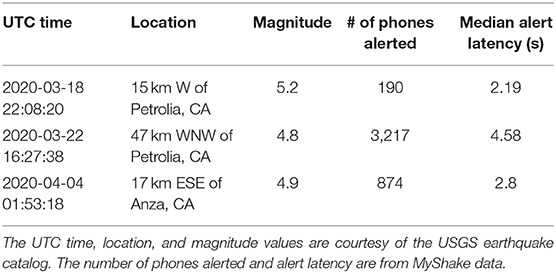
Table 1. Alert latency delivery data for the MyShake app.
Lessons learned from this initial stage are setting the groundwork for a more detailed analysis of the communication pathway speeds. MyShake continues to work at the intersection of earth science and telecommunications to make improvements to the data collection and delivery latencies.
Discussion
There are many practical implications of using public smartphones as an earthquake monitoring network, which include: the ethical considerations of privacy, expectation setting, and exogenous system changes. Some of these fall under the control of the app developers, such as ensuring user privacy, and expectation setting. Whereas, exogenous system changes to the Android or iOS framework is something the developers need to react to and plan for without being able to provide input.
The 2019 Ridgecrest earthquake sequence tested user expectation for alert delivery through the ShakeAlertLA app pilot. This provided an opportunity for MyShake to make changes to our app based on their experience, since like MyShake, ShakeAlertLA delivers ShakeAlert messages through their app to end users. The ShakeAlertLA app was available only to Angelinos at the time of the quakes and had a set threshold of MMI IV, below which no alerts would be delivered to user's phones. The largest earthquake in this sequence was the M7.1 event on July 5th, 2019. ShakeAlert underestimated the quake as a M6.3, so while the true observed shaking intensity did reach above MMI IV in Los Angeles, the estimate was lower, at an MMI III, so no deliveries were made to phones. The ShakeAlertLA app performed just as it should have, but public expectations were not met. Subsequently, the thresholds were refined by USGS to put them more in line with the expectations of the public, and that is now reflected in both apps. A delicate balance between alerting to meet expectations of the public who experience shaking and not over-alerting those who do not needs to be struck.
Intensity estimation errors, like those seen in the Ridgecrest sequence, can arise both from magnitude/location estimation errors, but also in local site variations. The soil type, building type, and other variables at a local site can have an impact on whether a user experiences the reported average shaking intensity for their area. Therefore, threshold refinements alone are not sufficient to address this issue. Continued education for the public that the alerts are best timely estimates and not exact, combined with training on what to do when shaking occurs should help. Further social science research into best practices and user behavior is needed. Moreover, there will be things to learn and refinements to be made as more alerts go out to the public over time.
Keeping up with exogenous changes such as Android/iOS updates, policy updates from ShakeAlert, and feedback from users regarding their perception of things is the third major practical implication and is ongoing. Android and iOS respond to their own user and business feedback by deploying new features and new improvements to their systems on a regular basis. Unfortunately for app developers, some of these changes require significant updates on the backend servers and application user interface to ensure continued operation. Examples of this are new protocols for message handling, updates or transitions to new cloud messaging systems, or changes to the available information in log files produced by the operating system. Developers constantly test the app to ensure that the message delivery and earthquake monitoring continue to function with each new update.
A simpler to implement, but continually ongoing exogenous requirement is the interface with the ShakeAlert System. Novel products produced by the United States Geological Survey will change the available information with which MyShake redistributes ShakeAlert information. Currently, thresholds are set to M4.5 and MMI III for smartphone apps, but that could change in the future as social science learns more about how people best respond to EEW information. Best practices in messaging, or new tone requirements put forward by ShakeAlert could impose new features or requirements on the application.
Constraints and Conclusion
We have outlined many of the constraints and considerations that go into developing an earthquake information app that combines citizen science and public warning aspects. Timely alert delivery is required in order for people to take action and drop, cover, hold on before shaking causes damage. Improving the timing requires technical cooperation between the external partners, internal developers, cloud servers, and the user's smartphones, all of which have different operational constraints and goals and requirements of their own. Unlike traditional seismic networks that make use of dedicated equipment that can be maintained and repaired by a centralized field crew, using smartphones as the seismic sensors removes much of the control we have over the instrumentation. Our network can only be as good as the phones available in the marketplace. Phones may be several generations old, or utilize very different accelerometer sensors with variable noise levels. Some users may heavily use their phones, whereas others may forget to turn them on for days. The team of developers do not have access to all of these phone types for testing, so much of the troubleshooting must be done after deployment.
Maintaining the privacy of our users and their data is an important constraint and consideration for both the software and user interface development. Our commitment to protecting privacy through anonymizing user information renders troubleshooting issues on individual phones more difficult. It also raises questions about long-term connectivity. Earthquakes that require alert delivery do not occur in a particular region on a regular basis. A particular user may wait months or years before an earthquake alert satisfying the threshold criteria strikes their area. Longevity studies on app performance and alert delivery will need to be undertaken. It remains unclear whether the underlying operating system will silence or put to sleep an app after months of non-use.
To conclude, many people work together to build this system, but not all stakeholders agree on which possible solutions to issues or new initiatives are the best. Reaching consensus requires presentation of known data and observations, transparency about the pros/cons of each pathway, and a consideration of each stakeholder's definition of project success. The public may have a very different idea of what makes a very successful earthquake app than the state, or the software development group. Understanding each perspective, distilling down what is possible and most useful, and then making decisions is the strategy we employ to keep the app relevant and useful.
The MyShake team works at the intersection of science, public communication, and technology to create a useable product for interested users around the world. The rollout of the app in October, 2019 as the official EEW for the State of California significantly increased our capacity to communicate with the public and solicit their feedback to improve the system. Lessons learned from the rollout inform our choices not only for public communication, but on the science and technology side as well. A large project like this, with many stakeholders and exogenous demands, navigates through a field of constraints. These challenges help us build a better system for the users, push forward technology and really understand system latencies, and harness the power of citizen scientists to create the seismic data sets of the future.
Author Contributions
JS, QK, and RA drafted the manuscript. RA approved the publication of the content. JS, QK, SPo, ST, RM, SA, SPa, and RA contributed to the conception and design the MyShake rollout.
Funding
Funding for the MyShake app alert delivery project was provided under a standard agreement with the California Governor's Office of Emergency Services (6142-2018).
Conflict of Interest
The authors declare that the research was conducted in the absence of any commercial or financial relationships that could be construed as a potential conflict of interest.
Acknowledgments
MyShake team would like to thank the Governor of California's Office for Emergency Services for their support and ongoing funding of this effort. We thank Dayi Chen and David Jay Wald for their review of the manuscript. We would also like to thank the USGS ShakeAlert project as well as the Gordon and Betty Moore foundation for the initial seed funding.
Footnotes
1. ^https://play.google.com/store/apps/details?id=org.emsc_csem.lastquake
2. ^https://play.google.com/store/apps/details?id=com.finazzi.distquake
References
Allen, R. M., Kong, Q., and Martin-Short, R. (2019). The myshake platform: a global vision for earthquake early warning. Pure Appl. Geophys. 177, 1699–1712. doi: 10.1007/s00024-019-02337-7
Allen, R. M., and Melgar, D. (2019). Earthquake early warning: advances, scientific challenges, and societal needs. Annu. Rev. Earth Planet. Sci. 47, 361–388. doi: 10.1146/annurev-earth-053018-060457
Anthony, R. E., Ringler, A. T., Wilson, D. C., and Wolin, E. (2019). Do low-cost seismographs perform well enough for your network? An overview of laboratory tests and field observations of the osop raspberry shake 4D. Seismol. Res. Lett. 90, 219–228. doi: 10.1785/0220180251
Aranda, J. M. E., Jimenez, A., Ibarrola, G., Alcantar, F., Aguilar, A., Inostroza, M., et al. (1995). Mexico city seismic alert system. Seismol. Res. Lett. 66, 42–53.
Bossu, R., Roussel, F., Fallou, L., Landès, M., Steed, R., Mazet-Roux, G., et al. (2018). LastQuake: from rapid information to global seismic risk reduction. Int. J. Dis. Risk Red. 28, 32–42. doi: 10.1016/j.ijdrr.2018.02.024
Chung, A. I., Neighbors, C., Belmonte, A., Miller, M., Sepulveda, H. H., Christensen, C., et al. (2011). The quake-catcher network rapid aftershock mobilization program following the 2010 m 8.8 Maule, Chile earthquake. Seismol. Res. Lett. 82, 526–532. doi: 10.1785/gssrl.82.4.526
Clayton, R. W., Heaton, T., Kohler, M., Chandy, M., Guy, R., and Bunn, J. (2015). Community seismic network: a dense array to sense earthquake strong motion. Seismol. Res. Lett. 86, 1354–1363. doi: 10.1785/0220150094
Finazzi, F. (2016). The earthquake network project: toward a crowdsourced smartphone-based earthquake early warning system. Bull. Seismol. Soc. Am. 106, 1088–1099. doi: 10.1785/0120150354
Given, D. D., Allen, R. M., Baltay, A. S., Bodin, P., Cochran, E. S., Creager, K., et al. (2018). Revised Technical Implementation Plan for the ShakeAlert System—An Earthquake Early Warning System for the West Coast of the United States. US Geological Survey. Available online at: https://pubs.er.usgs.gov/publication/ofr20181155 (accessed May, 2020).
Inbal, A., Kong, Q., Savran, W., and Allen, R. M. (2019). On the feasibility of using the dense myshake smartphone array for earthquake location. Seismol. Res. Lett. 90, 1209–1218. doi: 10.1785/0220180349
Jan, J. C., Huang, H. H., Wu, Y. M., and Chen, C. C. (2018). Near-real-time estimates on earthquake rupture directivity using near-field ground motion data from a dense low-cost seismic network. Geophys. Res. Lett. 45, 7496–7503. doi: 10.1029/2018GL078262
Kamigaichi, O. (2004). JMA earthquake early warning. J. Jpn. Assoc. Earthquake Eng. 4, 134–137. doi: 10.5610/jaee.4.3_134
Kong, Q., Allen, R. M., Kohler, M. D., Heaton, T. H., and Bunn, J. (2018). Structural health monitoring of buildings using smartphone sensors. Seismol. Res. Lett. 89, 594–602. doi: 10.1785/0220170111
Kong, Q., Allen, R. M., and Schreier, L. (2016a). MyShake: initial observations from a global smartphone seismic network. Geophys. Res. Lett. 43, 9588–9594. doi: 10.1002/2016GL070955
Kong, Q., Allen, R. M., Schreier, L., and Kwon, Y. W. (2016b). MyShake: a smartphone seismic network for earthquake early warning and beyond. Sci. Adv. 2:e1501055. doi: 10.1126/sciadv.1501055
Kong, Q., Inbal, A., Allen, R. M., Lv, Q., and Puder, A. (2019a). Machine learning aspects of the myshake global smartphone seismic network. Seismol. Res. Lett. 90, 546–552. doi: 10.1785/0220180309
Kong, Q., Patel, S., and Inbal, A. (2019b). Assessing the sensitivity and accuracy of the MyShake smartphone seismic network to detect and characterize earthquakes. Seismol. Res. Lett. 90, 1937–1949. doi: 10.1785/0220190097
Liang, W. T., Lee, J. C., and Hsiao, N. C. (2019). Crowdsourcing platform toward seismic disaster reduction: the Taiwan Scientific Earthquake Reporting (TSER) system. Front Earth Sci. Chin. 7:79. doi: 10.3389/feart.2019.00079
Rochford, K., Strauss, J. A., Kong, Q., and Allen, R. M. (2018). MyShake: using human-centered design methods to promote engagement in a smartphone-based global seismic network. Front Earth Sci. Chin. 6:237. doi: 10.3389/feart.2018.00237
Sakaki, T., Okazaki, M., and Matsuo, Y. (2010). “Earthquake shakes twitter users: real-time event detection by social sensors,” in Proceedings of the 19th International Conference on World Wide Web (ACM) (Raleigh, NC), 851–860. doi: 10.1145/1772690.1772777
Wald, D. J., Quitoriano, V., Dengler, L. A., and Dewey, J. (1999). Utilization of the internet for rapid community intensity maps. Seismol. Res. Lett. 70, 680–697. doi: 10.1785/gssrl.70.6.680
Wald, D. J., Quitoriano, V., Worden, M., Hopper, C. B., and Dewey, J. W. (2011). USGS “did you feel it?” internet based macroseismic intensity maps. Ann. Geophys. 39, 688–709. doi: 10.4401/ag-5354
Keywords: citizen science, seismology, smartphone, human-centered design, earthquake early warning
Citation: Strauss JA, Kong Q, Pothan S, Thompson S, Mejia RF, Allen S, Patel S and Allen RM (2020) MyShake Citizen Seismologists Help Launch Dual-Use Seismic Network in California. Front. Commun. 5:32. doi: 10.3389/fcomm.2020.00032
Received: 28 January 2020; Accepted: 22 April 2020;
Published: 19 May 2020.
Edited by:
Kate Huihsuan Chen, National Taiwan Normal University, TaiwanReviewed by:
Dayi Chen, Central Weather Bureau, TaiwanDavid Jay Wald, United States Geological Survey (USGS), United States
Copyright © 2020 Strauss, Kong, Pothan, Thompson, Mejia, Allen, Patel and Allen. This is an open-access article distributed under the terms of the Creative Commons Attribution License (CC BY). The use, distribution or reproduction in other forums is permitted, provided the original author(s) and the copyright owner(s) are credited and that the original publication in this journal is cited, in accordance with accepted academic practice. No use, distribution or reproduction is permitted which does not comply with these terms.
*Correspondence: Jennifer A. Strauss, amFzdHJhdXNzQGJlcmtlbGV5LmVkdQ==