
94% of researchers rate our articles as excellent or good
Learn more about the work of our research integrity team to safeguard the quality of each article we publish.
Find out more
ORIGINAL RESEARCH article
Front. Clim., 12 July 2022
Sec. Climate Services
Volume 4 - 2022 | https://doi.org/10.3389/fclim.2022.908662
This article is part of the Research TopicInsights in Climate Services: 2021View all 8 articles
 Faith Mitheu1,2*
 Celia Petty2,3
 Elena Tarnavsky2,4
 Elisabeth Stephens4,5
 Luisa Ciampi2Jonah Butsatsa6Rosalind Cornforth2
The provision of weather and climate information (WCI) can help the most at-risk communities cope and adapt to the impacts of extreme events. While significant progress has been made in ensuring improved availability of WCI, there remain obstacles that hinder the accessibility and use of this information for adaptation planning. Attention has now focused on the “usability gap” to ensure useful and usable WCI informs practise. Less attention has however been directed on barriers to the active production and use of WCI. In this study, we combine two frameworks through a bottom-up approach to present a more coordinated institutional response that would be required to ensure a better flow of information from information providers to users at community level and vice versa. The bottom-up approach was designed in form of Farmers Agri-Met Village Advisory Clinics (FAMVACs) and Listening Groups (LG) and was initiated by Uganda Meteorological Authority (UNMA) as a way of ensuring connections between the information providers, the disseminators, and the communities to specifically give voice to the communities to provide feedback on the use of WCI in coping with flood risks. This approach is used to identify the barriers and opportunities in the production/provision and use of WCI for flood risk preparedness for a case study in Eastern Uganda. First, a use-case is developed for Katakwi District where smallholder farming communities have recorded their coping practises and barriers to the use of WCI in practise. Second, online interviews with practitioners from disaster management institutions are used to identify barriers to the production and provision of WCI to local farming communities. Findings show that for providers, barriers such as accessibility and completeness of data hinder the production of useful WCI. In situations where useful information is available, technical language used in the format and timeliness in dissemination hinder usability by local farmers. Useful and usable WCI may not be acted on in practise due to factors such as costs or market availability e.g., lack of access to improved seeds. Further, the study highlights possible solutions to bridge the identified gaps and they include capacity building, fostering data collaborations across sectors, data translation to simple advisories, among others. The study also presents the FAMVACs approach which shows the importance of a more coordinated response with a shift of focus from the users of information only, to a more inclusive understanding of the data and information gaps across the wider provider-user landscapes. We argue that this would contribute to more effective disaster management at both the national and local levels.
Weather-driven shocks such as floods are becoming more extreme and frequent in many regions across the world (IPCC, 2012). Rural at-risk communities suffer the worst impacts from these extreme events because of their dependence on natural-based livelihoods (Pricope et al., 2013). Provision of Weather and Climate Information (WCI) can help these communities cope and adapt to the impacts of these extreme events (Roudier et al., 2016; Amegnaglo et al., 2017; Hansen et al., 2019). This is because WCI can inform appropriate actions to improve preparedness and reduce impacts (Jones et al., 2015). For example, scholarly literature notes that farmers who have access to timely WCI can plan their livelihoods activities for example when and what to plant, and appropriate farm management activities that may result in reduced impacts (Coulibaly et al., 2015; Naab et al., 2019).
Significant efforts and advancements in technology have resulted in increased availability of WCI (Dinku et al., 2014; Hewitt et al., 2020). However, this has not translated to improved accessibility, especially across user groups (practitioners and communities) in Africa where varied access to WCI is noted (Dinku, 2019; Vaughan et al., 2019). In addition, even if WCI is available and accessible, this does not necessarily mean the information is used to inform local decisions as it may not address the information needs of specific users (Vaughan and Dessai, 2014; Naab et al., 2019). These obstacles, commonly termed as information “usability gap” (Lemos et al., 2012) have been identified as major impediments to the use of WCI to inform climate-related decisions at all levels (Flagg and Kirchhoff, 2018; Ouedraogo et al., 2018).
In their study, Vincent et al. (2020) developed a framework that highlights three components that would enable closing the information usability gap and promote the use of WCI for climate risk management. These components have been broadly categorised as “useful” information which requires an understanding of the specific users' needs and their decision-making contexts to guide in identifying what information is useful (Carr et al., 2019), “usable” information if it's understandable by the intended user and is disseminated on time (Tembo-Nhlema et al., 2021) using appropriate communication channels (Barihaihi and Mwanzia, 2017) and an “enabling environment” such as supportive institutions (Vaughan et al., 2017) to ensure that useful and usable information gets used in practise.
The Vincent et al. (2020) framework builds on the climate services literature including Lemos et al. (2012) framework on bridging the information usability gap. In addition, it builds on the understanding that climate information use broadly links the user and the producers by knowledge sharing and collaborations through avenues such as co-production (Vincent et al., 2021). The three components, therefore, reflect both the supply and demand side of climate services towards ensuring more informed use of WCI for adaptation planning (Jones et al., 2015).
We however note that to ensure more coordinated institutional responses (such as that which would be required pre- and post-disaster) (UN, 2015) and a better flow of information (i.e., from practitioner to community and vice versa), additional components are required. First, further, to having an enabling environment, additional support based on other underlying socio-economic factors that influence how these communities cope may be required to ensure that the at-risk communities (“users” henceforth) actively use the information provided. For example, in a rural smallholder setting, having access to usable information may not necessarily translate to use in practise due to other individual or household social-economic factors such as income, education and age (Mittal and Hariharan, 2018; Shah et al., 2018, 2020; Petty et al., 2022). Similarly, a bottom-up approach that links the information providers, the disseminators and the communities would be required to ensure that the communities have a voice to interact and provide feedback on weather information use and their coping practises.
Second, the production of useful information goes beyond data availability (Goddard, 2016) and there remain other obstacles that could hinder the potential to produce and provide useful WCI, especially in the least developed countries. Essentially, decision-makers and information producers/providers (“providers” henceforth) require access to quality and credible “scientific” data and information to be able to fulfil the information needs of the users and manage the potential risks (Hewitt et al., 2020). But the required data and information is often limited (Van Den Homberg et al., 2017) or inaccessible (Susha et al., 2017; Dinku, 2019). In their framework, Van Den Homberg et al. (2017) notes that being data-prepared can help reduce the impacts associated with extreme events if high-quality data that meets the information needs of the providers are accessible before the disaster hits. The Van Den Homberg et al. (2017) framework focuses on five main components which include; “datasets” regarding data availability and accessibility, “data services” regarding services offered and software/hardware required, “data literacy” concerning the capability to transform the data to required information, “governance” looking at legal and regulatory rules on data sharing and “networking” which involves having long-term data collaborations. These components collectively would ensure that the lead institution for example, in disaster management has all the required data and information beforehand to guide disaster-related decisions.
In this study, we combine the two frameworks (Van Den Homberg et al., 2017; Vincent et al., 2020) through a bottom-up approach to present a more coordinated institutional response and flow of information. The bottom-up approach was designed in form of Farmers Agri-Met Village Advisory Clinics (FAMVACS) and Listening Groups (LG) and was initiated by UNMA as a way of ensuring connections between the information providers, and the communities to specifically give voice to the communities in contrast to the top-down approach (see Ciampi et al., 2019). This would allow better characterisation of the barriers that hinder effective provision and use of WCI across the provider-user landscapes as well as opportunities for improving the WCI use and uptake. In the context of this paper, we use WCI to refer to all information that would be required to prepare and respond to flood risks (and they include but are not limited to information on flood impacts, flood risks, hydrometeorology, socioeconomic, etc.). We have structured the study around three questions:
1) What barriers hinder the production/provision of useful WCI in the context of the providers? How can we improve provision?
2) What opportunities/barriers support/hinder the move from useful to usable information in the context of smallholder farmers?
3) What barriers deter useful and usable information from being used in practise by smallholder farmers? What can be done to improve uptake?
The study uses a bottom-up approach. Here, the bottom-up approach allows communities to be involved from the beginning in all activities that support improved preparedness. In contrast to the traditional top-down approach in disaster management, this study allowed the flood affected communities to record their own accounts of how floods have affected them and their coping practises. Further, disaster management practitioners were also given an opportunity to provide information on how they help the at-risk communities prepare for disasters. At the local level, a case study in Katakwi district, Uganda in the context of flood risks to livelihoods is used to give voice to the smallholder farming communities to record their coping practises, information needs, and the factors that hinder them from using the WCI to inform these coping practises. At the national level, online interviews with practitioners at disaster management agencies are used to understand how these agencies respond to the information needs of the users and barriers to effective provision of the required WCI.
In this paper, we combine the two frameworks (Van Den Homberg et al., 2017; Vincent et al., 2020) (Figure 1) and use them to identify the barriers and opportunities in the production/provision and use of WCI through a case study in Uganda. Two use-cases (more detailed below) are developed to help answer the research questions. We recognize that one of the barriers to the use of WCI as noted in literature is a lack of an enabling environment (Vaughan et al., 2017). However, a detailed investigation of the institutional structures and disaster/climate policies that governs how disaster management activities are undertaken in Uganda was out of scope in this paper. This section provides an overview of the study area, the use-cases, and data analysis methods.
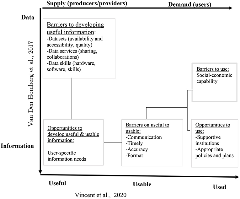
Figure 1. Conceptual framework used to identify the barriers and opportunities in the production/provision and use of WCI across the provider-user landscapes. Source: adapted from Vincent et al. (2020) and Van Den Homberg et al. (2017) and modified by authors.
Katakwi District, the focus of this study, is in the Eastern region of Uganda and lies between longitudes 33°48′E−34°18′E and latitudes 1°38′N−2°20′N. Katakwi borders Napak District in the north, Nakapiripirit in the east, Amuria in the west and northwest, Soroti in the southwest, and Kumi and Ngora in the south (Figure 2). The landscape is a plateau with undulating slopes in specific areas and lies approximately between 1,036 and 1,127 m above sea level (KDLG, 2014). The district is characterised by two livelihood zones, i.e., crop-livestock and fishing-livestock zones. Agriculture is predominantly rain-fed with two distinct rainfall seasons from March to May and September to November. The district experiences frequent heavy rains leading to flooding, which affects crop yields (KDLG, 2014). Common crops grown in Katakwi include sweet potatoes, cassava, maize, peas, rice, groundnuts, and a variety of local vegetables.
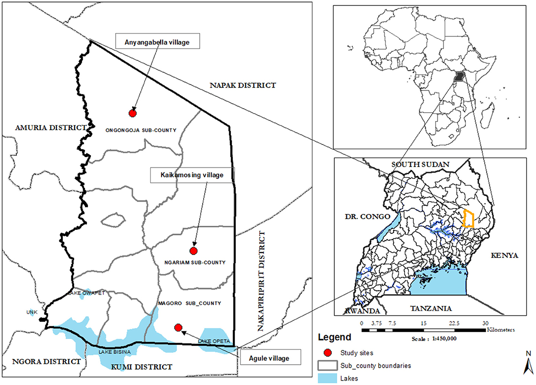
Figure 2. Location of the study sites in Katakwi District, Uganda.
The district was selected in discussion with NIMFRU (National scale Impact-based forecasting of Flood Risks in Uganda). NIMFRU is a project in Uganda to improve flood resilience through comprehensive flood impact assessments. The project is funded under Science for Humanitarian Emergencies and Resilience (SHEAR, 2018) program and it complements the previous SHEAR project (Forecast for Anticipatory Humanitarian Action-FATHUM) by providing a new approach that incorporates various types of information required to effectively deal with flooding. The project aim is to strengthen the capacity in interpreting and using weather and climate information, livelihood and socio-economic information among others to inform flood preparedness at all levels which would ensure improved resilience to floods (https://walker.ac.uk/research/projects/nimfru-national-scale-impact-based-forecasting-of-flood-risk-in-uganda/).
The district suffers severe impacts from floods every rainy season. The vast majority (81%) of the population in the district earn their livelihoods through subsistence farming (KDLG, 2014). Poverty levels are high with 88% of the population living below the poverty line (Kagugube et al., 2017). Project stakeholders include the Red Cross Climate Centre (RCCC), National Emergency Coordination and Operation Centre (NECOC), members of Parliament, local academic institutions, and civil organisations.
This study was undertaken as part of the community preparedness to flood risks initiative within the NIMFRU project (NIMFRU, 2018). As part of the Science for Humanitarian Emergencies and Resilience (SHEAR, 2018) program, the NIMFRU project set out to improve the targeting and communication of flood warnings and response to communities in the Katakwi District. To do this, the first use case targeting the flood-affected communities in three villages (Anyangabella, Agule, and Kaikamosing) in Katakwi district (Figure 2) was developed by the project team and used to conduct field research to gain a deeper understanding of the livelihoods, coping capacities, and practises of groups within the study communities, barriers to coping as well as their responses to flood hazards. A combination of quantitative and qualitative methodologies was used to inform this work, including quantitative livelihoods assessments, using the Household Economy Approach (HEA) (Seaman et al., 2014).
Fieldwork was carried out during the period February 2019 to February 2020. Initial work (data collected from February 2019 to August 2019) informed the creation and the representation of two interrelated communication platforms: The Farmer Voice Radio (FVR) Listening Groups, and the Farmer Agri-Met Village Advisory Clinics (FAMVACs) (Ciampi et al., 2019). The well-established FVR approach complemented the new Uganda National Meteorological Authority (UNMA) led FAMVAC initiatives, and a novel methodology was designed to ensure that both communication platforms provided a space for information needs and priorities to be identified locally. The platforms also facilitated open dialogues between community members and relevant district officials providing a “vertical” channel through which communities were able to feed their concerns and priorities directly into the Ugandan disaster response system. The methodology carefully ensured that there was relevant representation from both district and national authorities and that these initiatives were approved by NECOC and led by UNMA and the local non-governmental Organisation (NGO) Eco-Trust, to establish contextual validity, national ownership, and future sustainability. By the end of the fieldwork (February 2020), a total of 18 FAMVACs had taken place (six in each target community) with an average participation of 200 local community members, and 20 individual episodes of the FVR programme were aired reaching an estimated 67,000 people across rural Katakwi. Qualitative Field data collected from September 2019 to February 2020 using the developed FAMVACs methodology have been used in this paper and are explained further in the next subsection.
The second use case involved the disaster management (DM) agencies at the national level. The focus was to understand how these agencies respond to the information needs of the users, as well as to identify any gaps that hinder the effective production and provision of useful WCI. The sampling of the respondents was done through Purposive sampling techniques (Mohsin, 2016) which allowed us to choose the respondents based on predefined criteria and intended purpose. For this case, we considered national institutions and NGOs that take part in preparedness and response to natural disasters in Uganda1. A stakeholder mapping exercise allowed us to understand organisational roles and mandates before selecting them for interview. This exercise showed that more than 25 organisations (Supplementary Table 1) are involved in disaster management in Uganda. Due to Covid 19 restrictions and response responsibilities, only 14 of these organisations were available to take part in the interviews.
Data collection was undertaken separately for the affected communities and the DM agencies. At the community level, fieldwork, led by Eco-trust Uganda using the FAMVAC toolkit, took place over 6 months between September 2019 and February 2020 to gather information from the flood-affected communities through farmer's discussions and semi-structured interviews (see Supplementary Table 2 for sample interview questions). The data collection exercise took place in three villages which had been identified during the initial NIFMRU project fieldwork. We conducted 26 oral 1-on-1 semi-structured interviews with farmers in the three villages. Additionally, we held 18 farmers' discussions (six from each village) involving a large group of farmers (each farmers' group discussion consisted of ≈70 farmers). The interviews and discussions were done during the main rainy season. All interviews and discussions were carried out in the local language “Ateso” with an interpreter and were subsequently transcribed.
At the DM level, data collection took place from October 2020 to December 2020 through online semi-structured interviews. A staged process was used where first stakeholders mapping exercise was conducted based on the predefined criteria (see Section Developing the Use-cases). The second step involved sorting and identifying how many informants would be required from these institutions based on the number of departments and their roles. For example, an institution like Uganda National Meteorological Authority has both a forecasting and data centre hence more than one informant would be ideal. The third step involved contacting the institutions to provide the key informants to take part in the interviews. In total 14 institutions (see Table 1) took part in the interviews. Interview questions were framed around key themes such as their disaster management activities, information required, and the barriers to fulfilling the information needs of users (see Supplementary Table 3 for sample interview questions). For anonymity, the direct quotes from disaster management practitioners have been denoted with the pseudonym Disaster Respondent (DR).

Table 1. Institutions that took part in the online semi-structured interviews.
The software package Nvivo 12 for MS Windows (QSRInternational, 2018) was used for the analysis of the data from the local communities and the disaster management practitioners. The Nvivo programme, unlike manual methods of qualitative data analysis, offers the user an intricate, methodical, and iterative data interrogation process (Jackson and Bazeley, 2019). Data analysis in Nvivo is done through a content analysis approach where the mode of analysis can be either inductive or deductive (Elo and Kyngäs, 2008; Mayring, 2014). The inductive approach is used when the researcher has limited or no theory on the research outcome (Mayring, 2014) and entails letting the themes emerge from the raw data, while directed by existing components of the study (Harding, 2018). The deductive approach is based on a predetermined structure guided by previous findings, literature review, or an existing conceptual framework (Hsieh and Shannon, 2005; Mayring, 2014). In this study, we base our analysis on a combination of existing literature and frameworks on climate services and data preparedness (Van Den Homberg et al., 2017; Vincent et al., 2020) (see Figure 1) in a case study context hence the deductive content analysis approach is used to analyse our research data.
Deductively, the following steps were followed. First, the categorisation matrix based on themes from the framework presented in Figure 1 was developed. For this case, an unconstrained matrix was used to allow any other emerging concepts to be captured (Elo and Kyngäs, 2008). Table 2 shows the themes used in the categorisation matrix based on our research aim. Second the familiarisation phase was conducted. This involved reading through the transcripts to become aware of the ideas and words used by the respondents before coding. We then reviewed all the transcripts and coded them into the corresponding themes while also allowing the inclusion of any other emerging categories (Elo and Kyngäs, 2008). For information that did not fall into any of the existing themes, coding was done using words and phrases that the respondents used in their transcripts which ensured minimal misinterpretation. Coding was done separately for the community interviews and the disaster management interviews. However, the same themes were used.
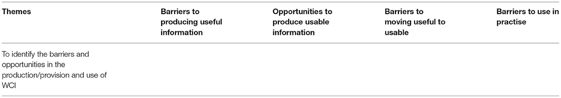
Table 2. Categorisation matrix showing the themes used in the coding of data in Nvivo.
To ensure trustworthiness, the analysis process has been explicitly explained and the themes used are supported by existing literature. The data has also been explicitly linked to the results from the analysis. In addition, to ensure validity of the coding process, two approaches have been used; visual representation (Siccama and Penna, 2008) and data scoping (Richards, 2004). For the visual representation, visual captures of the coding process have been done to authenticate the various steps used in coding (Supplementary Figures S1, S4). Scoping approaches using text query and matrix coding tools in Nvivo have been used to check the validity of coding (Richards, 2004). These tools allow identification of the commonly used words in specific themes and that were relevant in coding. For example, through matrix coding, the word “accessibility” was mentioned in nine out of 14 respondents (Supplementary Figure S2), with the majority coming from government and NGOs (Supplementary Figure S3). In addition, direct phrases/words from the respondents (such as “improved seeds, early harvesting”) were used as code sub-categories which reduces misinterpretation (Richards, 2014). Using the text query tool in Nvivo, we also verified if the phrase “improved seeds” used as a sub-category was relevant for coding. Results show that the same phrase was mentioned in eight out of nine transcripts from farmers' interviews (Supplementary Figure 5). The Phrase was mentioned more than once in five of the nine transcripts. This shows that it is relevant to use the same phrase in coding to ensure validity.
In this section, we present the outputs from the analysis of the research data based on broad themes identified during the coding and the research questions.
The DM practitioners expressed that most of the data that would be required to prepare for a disaster are available. These datasets include weather and climate data (rainfall, temperature, and river flow) and risk data (vulnerability, exposure, and hazard). The weather data is provided by UNMA, while disaster risk data comes from various institutions with the main ones being NECOC and the Uganda Bureau of Statistics (UBOS). These data support the main activities carried out during preparedness and response to flood risk. The main disaster preparedness activities are the dissemination of weather and climate information and the identification of flood risk areas.
Although “scientific” data is available, transforming these data into necessary and useful information is often hindered by various factors, as reported by the DM practitioners. First, these data are not easily accessible since they are held by individual institutions that have a mandate in data collection and production. A memorandum of understanding is often required between these institutions to facilitate data sharing. Due to institutional rules and regulations, the process of data sharing can however take longer than expected which affects the preparedness and response activities.
“Data from most of the institutions is not readily accessible due to institutional rules and guidelines on data sharing. The institution often demands a memorandum of understanding between the 2 institutions before sharing which can delay the process by up to 2 months. [DR01, DR04]”
Second, the data available lack the level of detail that would be required for comprehensive risk assessment at the local level (most data do not cover the village level). For example, most of the risk indicators such as those that would be required to understand the vulnerability of the communities to disasters vary in spatial coverage where some go up to sub-county while others up to county level, with none covering the village level. Weather data also does not give a full representation of the situation due to limited and scattered weather stations.
“There are gaps in the data available for example, the risk atlas covers up to district level and doesn't cover parishes and villages” [DR03].
“Weather Information is generalised to a very big area, but the farmers need localised information.” [DR014].
Third, not all the available data, especially the data on hazards and vulnerability are complete. In addition, some of the risk indicators such as the data on poverty levels, population density, and literacy levels are not up to date especially if they depend on national census data. This affects the development of up-to-date risk layers. The lack of a national flood forecasting system also affects the quality of information that is produced for flood risk management. If global flood forecast information is to be used to inform preparedness, it should be verified2 first for reliability. Although the development of the community Risk Assessment (CRA) framework is underway with support from the 510 group of the Netherlands Red Cross (NLRC) (NLRC, 2022), it is still hampered by the limited data available. The DM practitioners reported that this is based on secondary data and does not include any data collected from the grassroots level.
“Verified flood information is required to inform disaster management. Many global sources are available, but they need to be verified by the Ministry of Water and Environment before use” [DR02].
“Flood forecasting capacity is low in the country. They forecast rain and not floods” [DR012].
Last of all, institutions that have a role to transform data into the required information noted that they do have the required skills to do that. Frequent capacity building to keep up with evolving technology in climate science such as skills in forecasting and forecast evaluation is however required. Figure 3 shows the most common barriers to developing useful WCI.
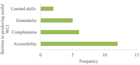
Figure 3. Barriers that hinder production of useful WCI.
Understanding the information needs of the users presents an opportunity to develop usable information. From our study, various information needs for the smallholder farmers have been identified based on the coping practises that the farmers undertake during flood preparedness. These information needs have been grouped into three themes: weather and climate, agricultural practises, and physical access to safe locations (Table 3). The information needs have also been grouped according to when it would be required. For example, the dynamic category includes information that would require an update every season. The second category captures situations where the dynamism of information would depend on the season. For instance, the location of safe areas may change depending on the magnitude of flooding experienced. What to plant and when to harvest will also depend on the rainfall factors such as duration, onset, etc.
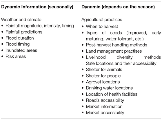
Table 3. Categorisation of farmers' information needs based on when they are required.
Useful information such as weather information is available and accessible to local farmers. However, the information does not meet farmers' needs due to various factors. First, the weather information is packaged in a technical format and disseminated in English which makes it hard for farmers to understand and use. For example, though the weather bulletins produced by UNMA are available through the district office, farmers are not able to utilise them especially if they do not have any advisories or if they are not interpreted in their local language.
Second, the timing of information dissemination is often unfavourable to local farmers. For example, both the farmers and DM practitioners reported that information should reach the farmers 1–2 months before the start of the season to help them prepare. In addition, since the information is issued quarterly, with frequent updates, sometimes the local farmers do not receive these updates to help them keep up to date with the changes in the weather patterns.
Third, the DM practitioners working at the local level reported that communication and dissemination of WCI is often exclusively top-down. Communities are therefore not able to share any feedback with the producers and the decision-makers. Table 4 lists these challenges together with quotes from both farmers and DM practitioners.
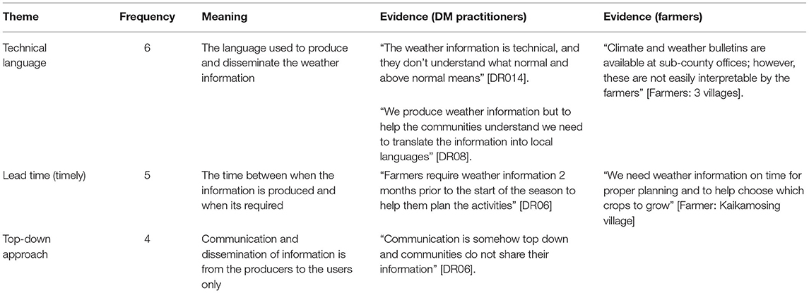
Table 4. Barriers that hinder useful information becoming usable in the context of smallholder farmers.
Smallholder farmers are aware of the recommended coping practises to be undertaken in preparedness for floods. The most common are on how to protect their crops before flooding, which includes early harvesting, post-harvest handling, and planting improved seeds. This is followed by ensuring their safety through activities such as clearing bushes and draining water from their compound. To protect livestock before floods, activities include vaccination, improving animal shelters, and buying improved breeds. Farmers in the study villages did not engage in many activities to enhance financial security, such as belonging to saving societies. Figure 4 highlights all the coping practises that were identified by farmers in Katakwi while Table 5 shows the most common coping practises based on the frequency.
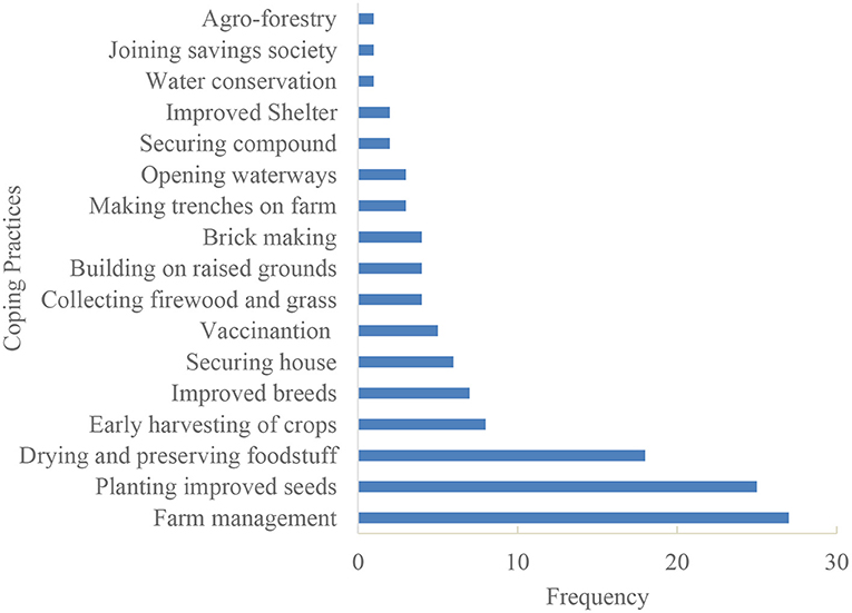
Figure 4. Coping practises used by flood-affected communities in the three villages (Anyangabella, Kaikamosing, and Agule) in Katakwi District, Uganda.
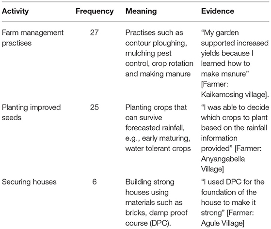
Table 5. Common coping practises undertaken by the farmers and their meaning.
Although the farmers were aware of the recommended coping practises, the actual implementation of these practises was hindered by various factors. These include agricultural-related challenges such as lack of improved seeds and other farm inputs. In addition, farmers in Katakwi do not have access to proper post-harvest handling kits to store their crops. Most of these challenges are associated with the social-economic capabilities of these communities, which we were not able to analyse further within the scope of this study.
Second, environmental factors such as invasion of desert locusts and the presence of strong winds were identified as challenges to implementing coping practises. Third, farmers noted that age and outbreaks of disease also derail the necessary coping practises. Figure 5 shows the common challenges that affect the actual implementation of the coping practises.
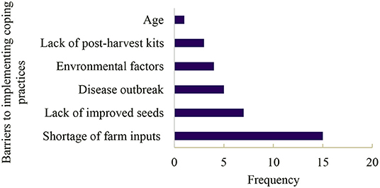
Figure 5. Barriers to implementing coping practises across the three villages (Anyangabella, Kaikamosing, and Agule) in Katakwi District, Uganda.
While the role of WCI in smallholder farmers' decision-making is now common knowledge (Roudier et al., 2014; Coulibaly et al., 2015), the understanding and use of WCI by farmers has not been very effective, especially where it does not meet their specific information needs (Carr et al., 2019). In addition, developing useful information is not only contingent on the availability of data (Goddard, 2016) but can also be hindered by various factors from the providers' side. The development of useful and usable WCI, therefore, requires a more coordinated flow of information from the providers to the users and vice versa to understand the barriers that hinder the provision and use of WCI. In this research, we have combined two frameworks through a bottom-up approach (FAMVACs method) to identify the barriers and opportunities across the provider-user landscapes on the production and use of WCI for a case study in Uganda. The approach used in this study to identify the barriers has a wider applicability across most natural disasters where a more coordinated response and flow of information would be required to understand the gaps in the provision and use of WCI for disaster management. Here, we first discuss the common barriers that hinder the production/provision and use of useful and usable WCI at the local level and the potential ways to address these barriers. We then highlight any future work that would be required to improve the use of WCI at the rural level. Figure 6 shows the various components for a coordinated institutional response and flow of information towards ensuring; (1) useful information is produced, (2) useful becomes usable, and (3) usable is used in practise based on the findings from Uganda.
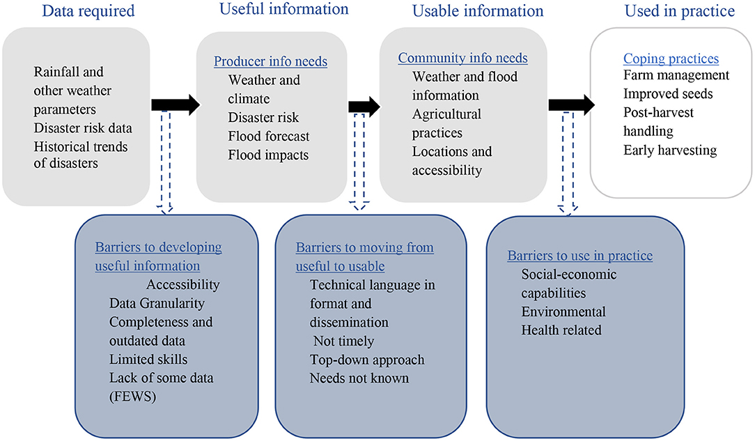
Figure 6. Components that would be required to achieve a more coordinated institutional responses and flow of information to ensure useful and usable information is produced/provided and used in practise: the component headings have been adopted from Vincent et al. (2020) and Van Den Homberg et al. (2017) while their contents are based on findings from Uganda.
Developing useful information spans beyond the available data to include other factors. Our findings show that barriers such as accessibility, completeness, and granularity of the data may hinder the development of useful information from the providers' side (see Figure 3). These dimensions are commonly used to check the quality of the available data and have been used to develop the data preparedness index (Van Den Homberg et al., 2017) as well as by other international organisations in data quality assessments to understand how prepared a country or an institution is in undertaking disaster management activities (WorldBank, 2012). These factors will however vary according to the context. For example, a study by Dinku (2019) found that the availability and completeness of climate data vary across Africa due to the scarcity of weather stations. In addition, the limited accessibility of available data has been attributed to the legal regulations that govern how institutions share data as well as the high costs levied to access the data.
In developing useful information, there is, therefore, a need to understand the data gaps that exist and how they can be addressed. The data quality dimensions noted above including others such as recency and reliability can be used to assess these gaps (Van Den Homberg et al., 2017). In Uganda, most of the required data to inform disaster preparedness is available. The accessibility of these data is however hindered by a lack of coordination between the various institutions involved in disaster management which means data is developed and managed by individual institutions (Atyang, 2014; Lumbroso, 2018). Having access to the data that meets the required quality dimensions can help bridge the providers' information gap (van den Homberg et al., 2018) and ensure that useful information is developed and made available for timely disaster preparedness and response. One way to ease data accessibility would be through embracing technology in data sharing for example through the use of multi-sector platforms such as the one developed by Cornforth et al. (2018). Fostering data collaborations across sectors can also help ensure that the required data is easily accessible (Susha et al., 2017).
Useful WCI becomes usable if it meets the information needs of the users. User needs are context-specific and evolving and will vary depending on livelihood type (Carr and Owusu-Daaku, 2016), geographical location, and gender among others (Barihaihi and Mwanzia, 2017; Carr and Onzere, 2018). This means that although useful climate information is becoming increasingly available (Hewitt et al., 2020), its usability will require a constant context-specific understanding of the climate information needs of the users to ensure that the information is tailored to their needs. In Katakwi district, farmers require information on weather and climate and appropriate agricultural practises (see Table 3) to inform their coping practises. This is also consistent with findings across Sub-Saharan Africa on the use of WCI to inform agricultural practises (Amegnaglo et al., 2017; Nyadzi et al., 2019). Farmers who have access to WCI which has been tailored to their needs can therefore benefit from undertaking the required coping and adaptation strategies (Singh et al., 2018; Vaughan et al., 2019).
The WCI available and accessible by farmers in Katakwi district are not timely (Tembo-Nhlema et al., 2021), and are too technical for them to understand and use (Barihaihi and Mwanzia, 2017; Nkiaka et al., 2019). For example, farmers would require weather information with a lead time of 1–2 months before the onset of the season to inform practises such as the acquisition of the required seed variety (Amegnaglo et al., 2017). In addition, the weather bulletins issued by UNMA come in English and the farmers would require translation to make them usable. Efforts to help translate the weather information are already seen under the collaboration between UNMA and local NGOs which can have a positive impact (Ouedraogo et al., 2018). Fostering communication between the users and providers can therefore help understand the WCI needs of the users as well as barriers that make useful information unusable. Ways to make the information usable including capacity building (Conway et al., 2017), interpretation of the information into simple advisories (Harvey et al., 2019), and co-production (Vincent et al., 2021) can then be explored based on the target user. Overall, engaging the users from the start in the production of WCI can help ensure the information is usable as well and trusted which then boosts uptake (Nkiaka et al., 2019). The extent up to which these solutions can be implemented will however depend on other factors. Scholarly studies have shown that limited financial and human resources can limit the level of preparedness among the local institutions (Shah et al., 2019). These factors should therefore be taken into consideration on top of the data preparedness factors to ensure that useful information is translated into usable information.
Availability and accessibility of useful and usable WCI by the target user does not necessarily translate to the actual use to inform coping practises. Although smallholder farmers may be aware of the coping practises to undertake (Berman et al., 2015; Shah et al., 2017; Wichern et al., 2017), studies have shown that one of the barriers to the use of WCI in practise is the lack of an enabling environment such as supportive institutions (Vaughan et al., 2017) to support adaptation planning. Other barriers such as the social-economic capabilities (age, income, health, etc.) of the users can also hinder use (Mittal and Hariharan, 2018; Shah et al., 2020). This means that even though useful and usable information that meets the needs of users is provided, the actual uptake of this information to inform coping practises will be context specific. For example, in this study, farmers in Katakwi district cannot afford the agricultural farm inputs required such as improved seeds (Fisher et al., 2015) to enable them to undertake the recommended coping practises. Other factors noted include limited land and inadequate farm tools (Tall et al., 2014). These factors have also been linked to financial resources to enable the farmers undertake these coping activities (Shah et al., 2017).
The benefits that farmers can derive from making use of WCI are many (Tarchiani et al., 2017; McKune et al., 2018; Ouedraogo et al., 2018). Hence, the barriers related to the socio-economic capabilities of the users and how they affect coping and adaptation should be identified so that the required support is provided (Petty et al., 2022). This could be done through existing institutions where interventions such as the provision of cash or subsidised farm inputs can be introduced (Assan et al., 2018). In addition, encouraging farmers to be part of farm-based organisations can help boost the uptake and use of WCI where these facilitate access to the required capital to support coping practises (Amegnaglo et al., 2017; Tarchiani et al., 2017).
Overall, the disconnect between the users and providers of WCI can result in ineffective use of WCI to inform local level decision-making (Lemos et al., 2012; Singh et al., 2016). A first step towards ensuring effective use would therefore be to identify barriers that hinder effective production/provision and use of WCI across the provider-user landscapes. By combining two frameworks (Van Den Homberg et al., 2017; Vincent et al., 2020), through a bottom-up FAMVAC approach, this study provides a more coordinated institutional response that would ensure a shift of focus from only the users to a more inclusive approach where even the data and information needs of the providers are identified. This would make it easy to characterize the gaps from both levels in a more dynamic way and ensure that the required support is provided. For example, findings from practitioners in Uganda indicate that the skills to work on “scientific” data are available, but as technology in the production of WCI changes, continuously building the technical capacity of these institutions will be important (Dinku, 2019; Mataya et al., 2020) to ensure that they can keep up with the demand for useful WCI.
The field of disaster risk management is shifting towards impact-based forecasting and forecast-based actions (Coughlan De Perez et al., 2016; WMO, 2021). Interventions that target the at-risk communities, should therefore consider their information needs, coping practises, and social-economic capabilities to ensure the design of more tailored interventions. In addition, understanding the capabilities of the information providers and the gaps that may hinder effectiveness in producing the required useful information will be important to ensure a more coordinated response to the user needs. As the impacts of weather-driven shocks on rural smallholder communities increase, these communities will continue to demand relevant and timely information to support their coping practises (Hansen et al., 2019). The providers will also need to be supported to meet these information needs. The potential benefits of WCI can therefore be realised through understanding the barriers to production and use of WCI at different levels and promoting required interventions to improve disaster preparedness and response activities. For example, through promoting coordination and collaborations among multiple providers to ease data accessibility (Susha et al., 2017) as well as ensuring that the needs of the users and barriers that affect effective utilisation of WCI are understood and streamlined into the disaster management plans to support community preparedness (Nurye, 2016).
Identifying barriers that hinder effective provision and use of WCI can inform the design of the required interventions. For example, a barrier such as data granularity (lack of data at the local level) can trigger support for frequent data collection at the local household level. Methods that are applicable based on context can then be assessed using criteria such as the one developed by Alkire and Samman (2014). Calculating the data preparedness index (Van Den Homberg et al., 2017) based on the quantifiable data quality dimensions can also help shed light on the improvement required to ensure that a country is prepared to undertake timely preparedness and response activities.
Barriers because of the social-economic capability of the users would also call for more in-depth methods to quantify the capability of these communities to undertake the coping practises and understand the type of support that would be required. Further research could look at an in-depth quantitative analysis of the household social-economic characteristics (sources of income, expenditures, health, age, etc.) such as that provided by HEA assessments (Seaman et al., 2014; Petty et al., 2022) and individual household surveys (Shah et al., 2020). Such an analysis can shed light not only on the household's capacity to undertake the various coping practises but also on the level up to which these households may require external support and the type of support required. Categorisation of the various coping practises stratified by wealth groups would also be essential to safeguard poor households against high-cost practises which may compromise their ability to cope in the future (Heltberg et al., 2009; Gautam and Andersen, 2016).
We did not get a chance to look at the disaster management structures and policies that govern how disaster-related activities are undertaken in Uganda. A thorough desktop study would therefore form part of future work to understand Uganda's plans for disaster risk reduction (DRR) including how various institutions coordinate to ensure emerging issues on disaster management are streamlined into the development process. Uganda has a DRR policy that was approved in the year 2011 (OPM, 2011) which stipulates the roles of various local and national institutions in addressing disasters. A study by Ampaire et al. (2017) however notes that the district and local level actors are often not included in the implementation of various policies. With climate variability expected to result in more extreme events, ensuring that the existing policies can still inform the required interventions is important. In addition, as we shift towards more locally targeted interventions, coordination between local and national institutions would be required to ensure that the needs of the most at-risk communities are centre in the design and implementation of the DRR policies.
The study findings have shown that the provision of useful and usable WCI spans beyond understanding the needs of the users—for this case the farmers—to include the data and information needs of the providers, and the capabilities of the users to use the information to inform practise. Ensuring that useful information is available, usable and is used in practise by the intended users is, therefore, an integral part of an effective disaster management plan. The barriers and opportunities to achieve positive impacts in the use of WCI should therefore be continuously assessed to ensure that developed WCI meets the needs of the potential users.
This study has provided a more coordinated institutional response approach that integrates two frameworks (Van Den Homberg et al., 2017; Vincent et al., 2020) and applies a bottom-up approach through the FAMVACs method to help identify the barriers and opportunities in the provision and use of WCI across user/user groups. Such an approach would ensure these barriers are identified across the user-provider landscape and solutions to bridge the specific gaps provided. Our findings on the barriers to provision and use of WCI are consistent with other scholarly findings in literature and are evidence of the various gaps that broadly affect the provision of climate services. However, specific solutions would be required depending on the context (user, location, etc.). For example, the lead time at which WCI should be provided to the local farmer will depend on the seasonal timing which varies across locations. In addition, designing solutions to improve data preparedness will require specific information on the gaps in the various data dimensions (access, availability, granularity, recency, etc.) which might also vary across contexts. The combined frameworks can therefore provide a coordinated way of ensuring that prior information required to inform development of specific solutions towards improving the provision of climate services are identified across the users and providers. This will also ensure that co-production takes centre stage in the design and dissemination of WCI.
Increased availability of weather and climate data and information provides an opportunity to improve climate adaptation planning. However, actionable programmes are needed to ensure that this information is translated and disseminated appropriately according to the information needs of the users. Weather information plays a fundamental role in informing the coping and adaptation among, for example, farming communities. There is therefore an urgent need to invest in strengthening the production, dissemination, and uptake of weather information for effective disaster management. This can be achieved by understanding the specific information gaps at the national and local levels which would also ensure that an improved dialogue is fostered between disaster management institutions and the at-risk communities for resilience building. Such information can then be used to improve disaster management plans and activities which would then ensure timely preparedness to floods.
The original contributions presented in the study are included in the article/Supplementary Material, further inquiries can be directed to the corresponding author/s.
The studies involving human participants were reviewed and approved by School of Archaeology Geography and Environmental Science (SAGES) Ethics Committee, University of Reading, UK. The patients/participants provided their written informed consent to participate in this study.
FM designed the research and collected the qualitative data at the national level, carried out the data analysis, and led the writing of the manuscript. CP led the design of the community-level research, collection of qualitative data, and assisted in writing the manuscript. RC, ES, and ET supported the research design and assisted in writing the manuscript. LC assisted in designing the qualitative research at the community level. JB assisted in collecting the qualitative data at the community level. All authors contributed to the article and approved the submitted version.
This research was funded by the UK's Natural Environment Research Council (NERC)-Science for Humanitarian Emergencies and Resilience Studentship Cohort (SHEAR SSC) grant number: NE/R007799/1, through the SHEAR FATHUM project (Forecasts for AnTicipatory HUManitarian action, grant number NE/P000525/1) and SHEAR catalyst NIMFRU project (National-scale IMpact-based forecasting of Flood Risk in Uganda, grant number NE/S00596X/1).
The authors declare that the research was conducted in the absence of any commercial or financial relationships that could be construed as a potential conflict of interest.
All claims expressed in this article are solely those of the authors and do not necessarily represent those of their affiliated organizations, or those of the publisher, the editors and the reviewers. Any product that may be evaluated in this article, or claim that may be made by its manufacturer, is not guaranteed or endorsed by the publisher.
We appreciate NECOC, ECO-Trust, and UNMA for taking part in the data collection process. We also acknowledge the participation of various Ugandan government institutions, NGOs, and the farmers from Katakwi District.
The Supplementary Material for this article can be found online at: https://www.frontiersin.org/articles/10.3389/fclim.2022.908662/full#supplementary-material
1. ^Here, we refer to all national-level institutions who fall into any or all of these recognized stakeholders' categories (data collectors, data analysers, intermediaries, decision-makers) and are responsible one way or another in collection, analysis and production of disaster information.
2. ^Verification here means that the flood forecasts information from global sources should be compared with ground-based river gauge observations or historical flood timelines to ensure that they capture the flood situation of the location.
Alkire, S., and Samman, E. (2014). Mobilising the Household Data Required to Progress toward the SDGs. In OPHI Working Paper 72. Available online at: http://www.ophi.org.uk/mobilising-the-household-data-required-to-progress-toward-the-sdgs/. doi: 10.35648/20.500.12413/11781/ii038
Amegnaglo, C. J., Anaman, K. A., Mensah-Bonsu, A., Onumah, E. E., and Amoussouga Gero, F. (2017). Contingent valuation study of the benefits of seasonal climate forecasts for maize farmers in the Republic of Benin, West Africa. Clim. Serv. 6, 1–11. doi: 10.1016/j.cliser.2017.06.007
Ampaire, E. L., Jassogne, L., Providence, H., Acosta, M., Twyman, J., Winowiecki, L., et al. (2017). Institutional challenges to climate change adaptation: a case study on policy action gaps in Uganda. Environ. Sci. Policy 75, 81–90. doi: 10.1016/j.envsci.2017.05.013
Assan, E., Suvedi, M., Olabisi, L. S., and Allen, A. (2018). Coping with and adapting to climate change: a gender perspective from smallholder farming in Ghana. Environ. – MDPI 5, 1–19. doi: 10.3390/environments5080086
Atyang, A. (2014). Study on Early Warning Systems in Uganda. Supported by United Nations Development Programme, October. UNDP.
Barihaihi, M., and Mwanzia, J. (2017). Enhancing farmers' resilience and adaptive capacity through access to usable weather information: a case study from Uganda. Clim. Change Manag. 617–627. doi: 10.1007/978-3-319-49520-0_38
Berman, R. J., Quinn, C. H., and Paavola, J. (2015). Identifying drivers of household coping strategies to multiple climatic hazards in Western Uganda: implications for adapting to future climate change. Clim. Dev. 7, 71–84. doi: 10.1080/17565529.2014.902355
Carr, E. R., Goble, R., Rosko, H. M., Vaughan, C., and Hansen, J. (2019). Identifying climate information services users and their needs in Sub-Saharan Africa: a review and learning agenda. Clim. Dev. 12, 23–41. doi: 10.1080/17565529.2019.1596061
Carr, E. R., and Onzere, S. N. (2018). Really effective (for 15% of the men): lessons in understanding and addressing user needs in climate services from Mali. Clim. Risk Manag. 22, 82–95. doi: 10.1016/j.crm.2017.03.002
Carr, E. R., and Owusu-Daaku, K. N. (2016). The shifting epistemologies of vulnerability in climate services for development: the case of Mali's agrometeorological advisory programme. Area 48, 7–17. doi: 10.1111/area.12179
Ciampi, L., Davis, H., Myers, J., Petty, C., Cornforth, R., Asalu, A., et al. (2019). FAMVAC and Listening Group Facilitation Handbook. Reading: Walker Institute.
Conway, D., Vincent, K., Grainger, S., Archer van Garderen, E., and Pardoe, J. (2017). How to Understand and Interpret Global Climate Model Results. Cape Town: FCFA.
Cornforth, R. J., Clegg, D., and Petty, E. C. (2018). Integrated Database for African Policymakers (Issue 2014).
Coughlan De Perez, E., Van Den Hurk, B., Van Aalst, M. K., Amuron, I., Bamanya, D., Hauser, T., et al. (2016). Action-based flood forecasting for triggering humanitarian action. Hydrology and Earth System Sciences 20, 3549–3560. doi: 10.5194/hess-20-3549-2016
Coulibaly, J. Y., Mango, J., Swamila, M., Tall, A., Kaur, H., and Hansen, J. (2015). Which Climate Services Do Farmers and Pastoralists Need in Malawi? Copenhagen: CGIAR Research Program on Climate Change, Agriculture and Food Security (CCAFS), 11.
Dinku, T. (2019). “Challenges with availability and quality of climate data in Africa,” in Extreme Hydrology and Climate Variability: Monitoring, Modelling, Adaptation and Mitigation (Elsevier Inc.), 71–80. doi: 10.1016/B978-0-12-815998-9.00007-5
Dinku, T., Block, P., Sharoff, J., Hailemariam, K., Osgood, D., del Corral, J., et al. (2014). Bridging critical gaps in climate services and applications in africa. Earth Perspect. 1, 15. doi: 10.1186/2194-6434-1-15
Elo, S., and Kyngäs, H. (2008). The qualitative content analysis process. J. Adv. Nurs. 62, 107–115. doi: 10.1111/j.1365-2648.2007.04569.x
Fisher, M., Abate, T., Lunduka, R. W., Asnake, W., Alemayehu, Y., and Madulu, R. B. (2015). Drought tolerant maize for farmer adaptation to drought in sub-Saharan Africa: determinants of adoption in eastern and southern Africa. Clim. Change 133, 283–299. doi: 10.1007/s10584-015-1459-2
Flagg, J. A., and Kirchhoff, C. J. (2018). Context matters: context-related drivers of and barriers to climate information use. Clim. Risk Manag. 20, 1–10. doi: 10.1016/j.crm.2018.01.003
Gautam, Y., and Andersen, P. (2016). Rural livelihood diversification and household well-being: insights from Humla, Nepal. J. Rural Stud. 44, 239–249. doi: 10.1016/j.jrurstud.2016.02.001
Hansen, J. W., Vaughan, C., Kagabo, D. M., Dinku, T., Carr, E. R., Körner, J., et al. (2019). Climate services can support African farmers' context-specific adaptation needs at scale. Front. Sustain. Food Syst. 3, 1–16. doi: 10.3389/fsufs.2019.00021
Harding, J. (2018). Qualitative Data Analysis: From Start to Finish. London: SAGE Publications Limited.
Harvey, B., Jones, L., Cochrane, L., and Singh, R. (2019). The evolving landscape of climate services in sub-Saharan Africa: what roles have NGOs played? Clim. Change 157, 81–98. doi: 10.1007/s10584-019-02410-z
Heltberg, R., Jorgensen, S., and Siegel, P. B. (2009). Addressing human vulnerability to climate change: toward a “No Regrets” approach. SSRN Electron. J. 19, 1–26. doi: 10.2139/ssrn.1158177
Hewitt, C. D., Allis, E., Mason, S. J., Muth, M., Pulwarty, R., Bucher, A., et al. (2020). Making society climate resilient. Am. Meteorol. Soc. 101, 237–252. doi: 10.1175/BAMS-D-18-0211.1
Hsieh, H. F., and Shannon, S. E. (2005). Three approaches to qualitative content analysis. Qual. Health Res. 15, 1277–1288. doi: 10.1177/1049732305276687
Jackson, K., and Bazeley, P. (2019). Qualitative Data Analysis with NVivo. London: SAGE Publications Limited.
Jones, L., Dougill, A., Jones, R. G., Steynor, A., Watkiss, P., Kane, C., et al. (2015). Ensuring climate information guides long-term development. Nat. Clim. Chang. 5, 812–814. doi: 10.1038/nclimate2701
Kagugube, J., Banga, M., Nsubuga, J., Bosco, M. J., Kyebambe, A., and Stephen, D. (2017). The Face of Poverty in Eastern Uganda – A Case of Katakwi District. Stanford Libraries.
Lemos, M. C., Kirchhoff, C. J., and Ramprasad, V. (2012). Narrowing the climate information usability gap. Nat. Clim. Chang. 2, 789–794. doi: 10.1038/nclimate1614
Lumbroso, D. (2018). How can policy makers in sub-Saharan Africa make early warning systems more effective? The case of Uganda. Int. J. Disaster Risk Reduct. 27, 530–540. doi: 10.1016/j.ijdrr.2017.11.017
Mataya, D. C., Vincent, K., and Dougill, A. J. (2020). How can we effectively build capacity to adapt to climate change? Insights from Malawi. Clim. Dev. 12, 781–790. doi: 10.1080/17565529.2019.1694480
Mayring, P. (2014). “Qualitative content analysis: theoritical foundations, basic procedures and software solutions,” in The SAGE Handbook of Qualitative Data Analysis (Sage), 170–183. doi: 10.4135/9781446282243.n12
McKune, S., Poulsen, L., Russo, S., Devereux, T., Faas, S., McOmber, C., et al. (2018). Reaching the end goal: do interventions to improve climate information services lead to greater food security? Clim. Risk Manag. 22, 22–41. doi: 10.1016/j.crm.2018.08.002
Mittal, S., and Hariharan, V. K. (2018). Mobile-based climate services impact on farmers risk management ability in India. Clim. Risk Manag. 22, 42–51. doi: 10.1016/j.crm.2018.08.003
Mohsin, A. (2016). A Manual for Selecting Sampling Techniques in Research. Munich: University of Karachi, Iqra University. Munich Personal RePEC Archive, 1–56.
Naab, F. Z., Abubakari, Z., and Ahmed, A. (2019). The role of climate services in agricultural productivity in Ghana: the perspectives of farmers and institutions. Clim. Serv. 13, 24–32. doi: 10.1016/j.cliser.2019.01.007
NIMFRU (2018). NIMFRU. Avaialble online at: http://www.walker.ac.uk/research/projects/nimfru-national-scale-impact-based-forecasting-of-flood-risk-in-uganda/ (accessed January 4, 2021).
Nkiaka, E., Taylor, A., Dougill, A. J., Antwi-Agyei, P., Fournier, N., Bosire, E. N., et al. (2019). Identifying user needs for weather and climate services to enhance resilience to climate shocks in sub-Saharan Africa. Environ. Res. Lett. 14, 123003. doi: 10.1088/1748-9326/ab4dfe
NLRC (2022). Community Risk Assessment. Avaialble online at: https://dashboard.510.global/#!/community_risk (accessed March 3, 2022).
Nurye, A. A. (2016). Blending science and community voices for multi-scale disaster risk reduction and climate resilience: A participatory scenario planning approach. Preprint. 2016080105. doi: 10.20944/preprints201608.0105.v1
Nyadzi, E., Saskia Werners, E., Biesbroek, R., Long, P. H., Franssen, W., and Ludwig, F. (2019). Verification of seasonal climate forecast toward hydroclimatic information needs of rice farmers in northern Ghana. Weather Clim. Soc. 11, 127–142. doi: 10.1175/WCAS-D-17-0137.1
OPM (2011). The National Policy For Disaster Preparedness And Management Department of Disaster Preparedness and Management Office of the Prime Minister The Republic of Uganda. April. Avaialble online at: http://www.necoc-opm.go.ug/publications/1. National Policy for Disaster Preparedness and Management.pdf
Ouedraogo, I., Diouf, N. S., Ouédraogo, M., Ndiaye, O., and Zougmoré, R. B. (2018). Closing the gap between climate information producers and users: assessment of needs and uptake in Senegal. Climate 6, 1–16. doi: 10.3390/cli6010013
Petty, C., Ngoleka, S., Cornforth, R., Achiro, E., Acidri, J., Ainslie, A., et al. (2022). Adaptation planning: an integrated approach to understanding vulnerability in the Lake Victoria Basin. Front. Clim. 3, 1–15. doi: 10.3389/fclim.2021.782534
Pricope, N. G., Husak, G., Lopez-Carr, D., Funk, C., and Michaelsen, J. (2013). The climate-population nexus in the East African Horn: emerging degradation trends in rangeland and pastoral livelihood zones. Glob. Environ. Change 23, 1525–1541. doi: 10.1016/j.gloenvcha.2013.10.002
QSRInternational (2018). Qualitative Data Analysis Software: NVivo. Avaialble online at: https://www.qsrinternational.com/nvivo-qualitative-data-analysis-software/home (accessed December 15, 2020).
Richards, L. (2004). “Validity and reliability? Yes! Doing it in software,” in Strategies Conference (London: University of Durham).
Roudier, P., Alhassane, A., Baron, C., Louvet, S., and Sultan, B. (2016). Assessing the benefits of weather and seasonal forecasts to millet growers in Niger. Agric. For. Meteorol. 223, 168–180. doi: 10.1016/j.agrformet.2016.04.010
Roudier, P., Muller, B., D'Aquino, P., Roncoli, C., Soumaré, M. A., Batté, L., et al. (2014). The role of climate forecasts in smallholder agriculture: lessons from participatory research in two communities in Senegal. Clim. Risk Manag. 2, 42–55. doi: 10.1016/j.crm.2014.02.001
Seaman, J. A., Sawdon, G. E., Acidri, J., and Petty, C. (2014). The household economy approach. Managing the impact of climate change on poverty and food security in developing countries. Clim. Risk Manag. 4, 59–68. doi: 10.1016/j.crm.2014.10.001
Shah, A. A., Shaw, R., Ye, J., Abid, M., Amir, S. M., Kanak Pervez, A. K. M., et al. (2019). Current capacities, preparedness and needs of local institutions in dealing with disaster risk reduction in Khyber Pakhtunkhwa, Pakistan. Int. J. Disaster Risk Reduct. 34, 165–172. doi: 10.1016/j.ijdrr.2018.11.014
Shah, A. A., Ye, J., Abid, M., Khan, J., and Amir, S. M. (2018). Flood hazards: household vulnerability and resilience in disaster-prone districts of Khyber Pakhtunkhwa province, Pakistan. Nat. Hazards 93, 147–165. doi: 10.1007/s11069-018-3293-0
Shah, A. A., Ye, J., Abid, M., and Ullah, R. (2017). Determinants of flood risk mitigation strategies at household level: a case of Khyber Pakhtunkhwa (KP) province, Pakistan. Nat. Hazards 88, 415–430. doi: 10.1007/s11069-017-2872-9
Shah, A. A., Ye, J., Shaw, R., Ullah, R., and Ali, M. (2020). Factors affecting flood-induced household vulnerability and health risks in Pakistan: the case of Khyber Pakhtunkhwa (KP) Province. Int. J. Disaster Risk Reduct. 42, 101341. doi: 10.1016/j.ijdrr.2019.101341
SHEAR (2018). Science for Humanitarian Emergencies and Resilience (SHEAR) Catalyst grants. Avaialble online at: http://www.shear.org.uk/home.html (accessed February 4, 2021).
Siccama, C. J., and Penna, S. (2008). Enhancing validity of a qualitative dissertation research study by using NVIVO. Qual. Res. J. 8, 91–103. doi: 10.3316/QRJ0802091
Singh, C., Daron, J., Bazaz, A., Ziervogel, G., Spear, D., Krishnaswamy, J., et al. (2018). The utility of weather and climate information for adaptation decision-making: current uses and future prospects in Africa and India. Clim. Dev. 10, 389–405. doi: 10.1080/17565529.2017.1318744
Singh, C., Dorward, P., and Osbahr, H. (2016). Developing a holistic approach to the analysis of farmer decision-making: implications for adaptation policy and practice in developing countries. Land Use Policy 59, 329–343. doi: 10.1016/j.landusepol.2016.06.041
Susha, I., Janssen, M., and Verhulst, S. (2017). “Data collaboratives as a new frontier of cross-sector partnerships in the age of open data: taxonomy development,” in Proceedings of the Annual Hawaii International Conference on System Sciences 2017-Januay, 2691–2700. doi: 10.24251/HICSS.2017.325
Tall, A., Hansen, J., Jay, A., Campbell, B., Kinyangi, J., Aggarwal, P. K., et al. (2014). Scaling up climate services for farmers: Mission Possible. 13. Avaialble online at: http://agritech.tnau.ac.in/ta/Agriculture/pdf/csa_pdf/Scaling_up_climate_services_for_farmers.pdf (accessed March 5, 2022).
Tarchiani, V., Rossi, F., Camacho, J., Stefanski, R., Mian, K. A., Pokperlaar, D. S., et al. (2017). Smallholder farmers facing climate change in West Africa: decision-making between innovation and tradition. J. Innov. Econ. Manag. 24, 151–176. doi: 10.3917/jie.pr1.0013
Tembo-Nhlema, D., Vincent, K., and Henriksson, R. (2021). “Creating useful and usable weather and climate information: insights from participatory scenario planning in Malawi,” in Climate Risk in Africa, eds D. Conway and K. Vincent (library.oapen.org), 77–92. doi: 10.1007/978-3-030-61160-6_5
UN (2015). “Sendai framework disaster for risk reduction,” in The Oxford Handbook on the United Nations (United Nations), 1–15.
van den Homberg, M., Monné, R., and Spruit, M. (2018). Bridging the information gap of disaster responders by optimizing data selection using cost and quality. Comput. Geosci. 120, 60–72. doi: 10.1016/j.cageo.2018.06.002
Van Den Homberg, M., Visser, J., and Van Der Veen, M. (2017). “Unpacking data preparedness from a humanitarian decision making perspective: toward an assessment framework at subnational level,” in Proceedings of the International ISCRAM Conference, 2017 (May), 2–13.
Vaughan, C., and Dessai, S. (2014). Climate services for society: origins, institutional arrangements, and design elements for an evaluation framework. Wiley Interdiscip. Rev.: Clim. Change 5, 587–603. doi: 10.1002/wcc.290
Vaughan, C., Dessai, S., Hewitt, C., Baethgen, W., Terra, R., and Berterretche, M. (2017). Creating an enabling environment for investment in climate services: the case of Uruguay's National Agricultural Information System. Clim. Serv. 8, 62–71. doi: 10.1016/j.cliser.2017.11.001
Vaughan, C., Hansen, J., Roudier, P., Watkiss, P., and Carr, E. (2019). Evaluating agricultural weather and climate services in Africa: evidence, methods, and a learning agenda. Wiley Interdiscip. Rev.: Clim. Change 10, 1–33. doi: 10.1002/wcc.586
Vincent, K., Conway, D., Dougill, A. J., Pardoe, J., Archer, E., Bhave, A. G., et al. (2020). Re-balancing climate services to inform climate-resilient planning – a conceptual framework and illustrations from sub-Saharan Africa. Clim. Risk Manag. 29, 1–7. doi: 10.1016/j.crm.2020.100242
Vincent, K., Steynor, A., McClure, A., Visman, E., Waagsaether, K. L., Carter, S., et al. (2021). “Co-production: learning from contexts,” in Climate Risk in Africa (Cham: Palgrave Macmillan), 37–56.
Wichern, J., Wijk, M. T., Van Descheemaeker, K., van Wijk, M. T., Descheemaeker, K., Frelat, R., et al. (2017). Food availability and livelihood strategies among rural households across Uganda. Food Secur. 9, 1385–1403. doi: 10.1007/s12571-017-0732-9
WMO (2021). WMO Guidelines on Multi-Hazard Impact-based Forecast and Warning Services (Issue 1150). Available online at: https://library.wmo.int/doc_num.php?explnum_id=7901 (accessed January 26, 2022).
Keywords: community information needs, weather and climate information, smallholder farmers, information providers, flood risk management
Citation: Mitheu F, Petty C, Tarnavsky E, Stephens E, Ciampi L, Butsatsa J and Cornforth R (2022) Identifying the Barriers and Opportunities in the Provision and Use of Weather and Climate Information for Flood Risk Preparedness: The Case of Katakwi District, Uganda. Front. Clim. 4:908662. doi: 10.3389/fclim.2022.908662
Received: 30 March 2022; Accepted: 15 June 2022;
Published: 12 July 2022.
Edited by:
Colin Kelley, Columbia University, United StatesCopyright © 2022 Mitheu, Petty, Tarnavsky, Stephens, Ciampi, Butsatsa and Cornforth. This is an open-access article distributed under the terms of the Creative Commons Attribution License (CC BY). The use, distribution or reproduction in other forums is permitted, provided the original author(s) and the copyright owner(s) are credited and that the original publication in this journal is cited, in accordance with accepted academic practice. No use, distribution or reproduction is permitted which does not comply with these terms.
*Correspondence: Faith Mitheu, Zi5rLm1pdGhldUBwZ3IucmVhZGluZy5hYy51aw==
Disclaimer: All claims expressed in this article are solely those of the authors and do not necessarily represent those of their affiliated organizations, or those of the publisher, the editors and the reviewers. Any product that may be evaluated in this article or claim that may be made by its manufacturer is not guaranteed or endorsed by the publisher.
Research integrity at Frontiers
Learn more about the work of our research integrity team to safeguard the quality of each article we publish.