- 1Professional School of Architecture, Universidad Peruana Unión, Tarapoto, Peru
- 2University Professor, Universidad Peruana Unión, Tarapoto, Peru
The San Martín region, located in the Peruvian jungle, presents ecological constraints regarding environmental tourism, encompassing natural and cultural resources. However, unplanned urban growth is degrading the urban landscape, with the town center of San Antonio being the most affected, losing approximately 377 ha. in natural forest. Therefore, this research presents the following question: How do ecological tourism hubs articulate the sustainable urban landscape of the Morales–San Antonio axis? The objectives of this research are to identify centers of ecological tourism, delimit perimeters and geomorphological patterns, interpret the territory and its transition through landscape transformations, and recognize the social tourism dynamics of people in the province. Likewise, this research has a qualitative approach, whose instruments were the observation sheet, open interview, and municipal documents, and the data collection techniques were through satellite images, cartography, photographic records, and design software. The result is evidence of an axis with tourism potential in the city of Tarapoto, which is experiencing very accelerated urban growth and where urbanized ecological places can be seen. Indicators were also identified for tourism centers organized into four groups: buildings with tourism potential, natural remnants, ecological areas, and permanently flooded and/or swampy areas. Finally, it is concluded that the city of Tarapoto has ecological tourism centers and that these are articulated in the sustainable urban landscape of the Morales–San Antonio axis.
1 Introduction
According to the World Tourism Organization (WTO, 2022), global tourism has experienced a growth of 4%, representing 415 million arrivals by the year 2021, compared to 400 million international tourist arrivals in 2020. Very low figures were obtained before the pandemic; however, the WTO has begun to notice recovery in this sector (p. 1). Something similar has occurred with ecotourism, also known as ecological tourism (Gambarota and Lorda, 2024), which is a type of alternative tourism that includes activities carried out in natural areas, thus conserving the environment (Leal Londoño and del, 2017).
However, its growth is accelerated, taking on great importance because it is one of the most relevant sectors at a global level, above the tourism industry in general (UICN, 2022). Thus, according to the study prepared by Tudela Mamani et al. (2022), this sector is the third most important in the world economy in terms of exports, representing 10.3% of the gross domestic product (GDP) worldwide, giving job opportunities to more than 330 million people; this indicates that such practice should be given importance, and regions with environmental indicators have potential for nature tourism development (Ezaquias, 2022).
Such is the case of San Martín, a region in Peru that contributes to sustainable tourism, which is one of the industries with the greatest commitment to low environmental and cultural impact while also providing employment and income to the local population (Municipalidad Provincial de San Martín, 2019).
Currently, the construction sector presents a negative impact on the natural environment (Álvarez Calixto et al., 2020), leading to resource depletion, ecosystem imbalance, and other problems, including negative effects on human health (Enshassi et al., 2014). For this reason, various studies acknowledge the existence of areas with tourism riches, as well as the presence of ecological tourism hubs, considering the characteristics of the zone. These tourism clusters in the region, primarily in the city of Tarapoto, are categorized into three zones: Environmental Protection Zones (ZPA), Ecological Protection Zones (ZPE), and Spatial Zones (ZGE) (Municipalidad Provincial de San Martín, 2019).
However, the city of Tarapoto is experiencing rapid urban growth (Arévalo and León, 2017), resulting in the loss of a significant portion of vegetation cover, thus diminishing its visual appeal. The research aims to develop strategies through theoretical and practical study of the natural landscape, considering zonal tourism as one of the priorities (Rodríguez Martínez, Ramírez Pérez & Pérez Hernández, 2020), transforming the image of a rural district to turn it into a tourist product with key activities that drive the region (Fuller, 2011). The study analyzes the connection of hubs, landscape transformation, and tourism dynamics.
Instruments and techniques are being developed to implement tools for on-site interpretation of the areas identified as hubs at local, district, and provincial scales, with particular attention to points where ecotourism is present and where landscape organization is intended.
Finally, international precedents such as Fernández Tabales and Santos Pavón (2018) and Briceño (2018) highlight the interrelation between urban landscapes and tourism. National studies by Hernández Ramírez, (2020) and Esparza et al. (2020) affirm that they are relational areas of more practical social ways of life; thus, ecological tourism through defined spaces becomes a sustainability alternative. In this sense, ecotourism is becoming one of the most effective ways to avoid irreversible damage to reduce costs not only in the social and economic spheres but also in the environmental spheres affecting local residents, thus preserving sectors with high-value ecosystems (Saeteros Hernández et al., 2019). Therefore, these precedents suggest the need for studies focused on identifying ecological tourism hubs as organizers of sustainable landscapes in the city of Tarapoto, encompassing their ecological components and relationship with the territory.
In this context, the proposal is to organize the urban landscape through ecological tourism hubs that can protect, conserve, and maintain ecological areas and consequently, promote the tourist competitiveness of the Morales–San Antonio axis.
The study has the following objectives: Delimiting the perimeters and geomorphological patterns of the hubs to understand the articulation of sustainable urban landscape in the district of Morales–San Antonio; interpreting the territory and its transition through landscape transformations in the natural axis of the district of Morales–San Antonio, and understanding the social tourism dynamics of the people in the province of San Martín, grasping the activities carried out by the population of the province.
Thus, this research poses the following question: How do ecological tourism hubs articulate the sustainable urban landscape of the Morales–San Antonio axis?
2 Methodology
Case study: The Morales–San Antonio Route.
This research takes place in San Martín Province, geographically located in northern Peru. It shares its northeastern border with Loreto, with Picota to the south and Lamas to the west, with the central capital being Tarapoto (see Figure 1). The study focuses on the area between the districts of Morales and San Antonio.
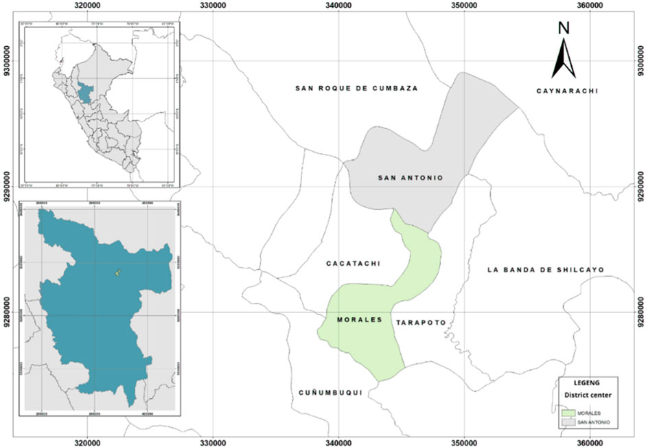
Figure 1. Location from macro to micro of Peru and the department and province of San Martín, Morales, and San Antonio. Source 1: Self-made, ArcGis software. District of Morales: Population of 43,481. M-SA Route: 18.7 km. District of San Antonio: Population of 1,674.
2.1 Focus and data collection techniques
The present research adopts a qualitative approach method. As mentioned by (Hernández Sampieri, Fernández Collado and Baptista Lucio, 2014, pp. 7–9), qualitative research is a scientific method based on observation for the collection of non-numeric data and the collection of data that are not completely standardized or predetermined. Such collection consists of obtaining the perspectives and points of view of the participants. This research has a descriptive-non-experimental/correlational scope, which is a scientific methodology based on the observation and description of variable behavior (Guevara Alban et al., 2020, pp. 166–167). The research used a case study design because it contemplated the analysis of a phenomenon, allowing us to understand and know the strategies through the information developed in the field, as well as the theories and perspectives of other investigations, thus substantiating and contributing to the investigation.
2.2 Population and sample
In this research, the population under study comprised the “Ecotourism hubs” along the Morales–San Antonio axis in San Martín (see Figure 2).
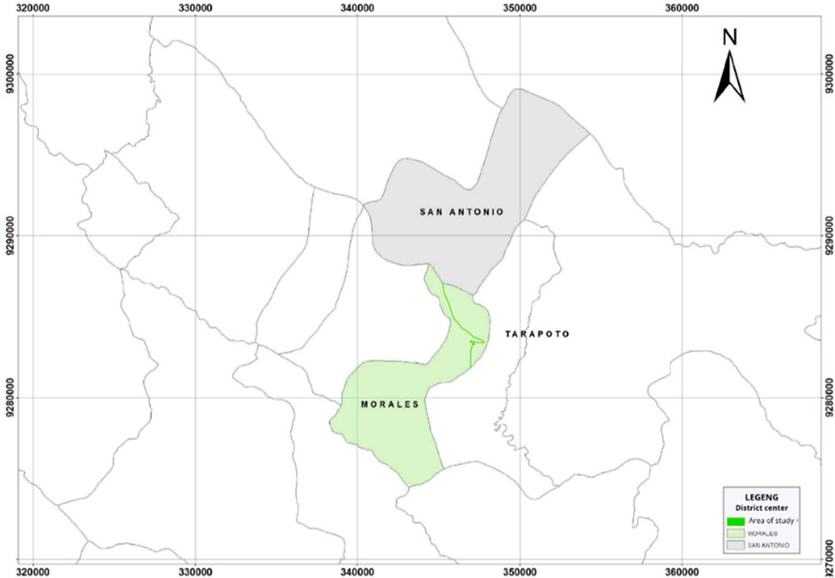
Figure 2. Study area location (Morales–San Antonio articulation axis). Source 2: Self-made, ArcGis software.
For this, the indicators that comprise these terms were considered: areas containing buildings with tourism potential, ecological areas, natural remnants, and permanently flooded and/or swampy areas (see Figure 3), from which residential buildings (houses) were excluded. Subsequently, a survey of 23 hubs was conducted: Km3, Río Lookout, El Trapiche, Gin-tonic, Wayruro, Piñarreta Esplanade, “El Gran Paso” Fairground, Stairway Lookout, Añuje Loco, Aguajales, San Antonio de Cumbaza Beaches, Unnamed Lookout, Paradise Entrance, Cuy Wasi, La Curva Restobar, Z. Club Lookout, Tree House, Tamoba Lookout, Tropicocos, Las Sombrillas, Stairway Mountain Range, Wide Vegetation Areas, and San Pedro de Cumbaza Riverbank. These locations were selected based on the aforementioned criteria.

Figure 3. Maps of interpretation and transition of the Morales–San Antonio articulation axis in 1969, 2004, and 2023. Source 5: Self-made.
Finally, 10 hubs were selected as the sample for this article: Río Lookout, El Trapiche, Piñarreta Esplanade, “El Gran Paso” Fairground, Aguajales, Tree House, Las Sombrillas, Stairway Mountain Range, Wide Vegetation Areas, and San Pedro de Cumbaza Riverbank, extracted from the percentage of attendance of the population of San Martín.
2.3 Instruments for data collection analysis
The instruments used in the research were as follows:
Observation Sheet: Its application is aimed at achieving Objective 1. Indicators of ecotourism hubs and delimiting the perimeters and geomorphological patterns of existing hubs. Field visits were conducted, notes and photographs were taken, and these were compared with municipal documents.
Open Interviews: This was conducted to achieve Objective 3, involving international, national, and local tourists. References regarding social tourism dynamics were obtained, and the activities and preferences along the Morales–San Antonio axis were understood.
Municipal Documents: These documents were part of the analysis process to achieve Objective 2. They helped interpret the territory and its transition through landscape transformations along the natural axis of the Morales–San Antonio district.
Satellite Image Analysis: Images were used in the analysis for Objective 1. They included views over the years to capture urban growth and the state of the landscape along the articulation axis.
Mapping: Mapping was part of Objective 2, allowing for macro and micro-level visualization of the analysis area. The sector was considered the sector as it currently stands, presenting the most up-to-date and realistic information possible.
2.4 Phases for the data collection analysis process
Table 1: Data Analysis Phases.
2.5 Definition of variables
Dependent (D)–Independent (I):
Variable D: Ecotourism hubs.
Variable I: Sustainable urban landscape.
Where:
M: Sample represented by ecotourism hubs organizing the sustainable urban landscape along the Morales–San Antonio articulation axis.
V1: Ecotourism hubs.
r: Relationship between the study variables.
V2: Sustainable urban landscape.
Four important indicators were considered: buildings with tourism potential, natural remnants, ecological areas, and permanently flooded and/or swampy areas. Each of these indicators presents nuclei that are described in Table 2.
3 Results and discussion
3.1 Morales–San Antonio articulation axis
The city of Tarapoto is becoming the third most organized territorial area in the Peruvian Amazon (Rondón Ramírez, 2017, pp. 100–101). It boasts an anomalous topographical environment in the city center, with a reduction in altitude as it approaches the riverbanks. This leads to a variety of platforms, creating microclimates and diverse vegetation, which in turn provide comfortable spaces for residents. These spaces aim to mitigate the elevated climate in the city, enhancing livability in the urban fabric.
The entire department of San Martín is filled with vegetation, exhibiting diverse structures. However, the rural poverty index leads to the most vulnerable sectors in need of housing, positioning themselves over territorial and environmental resources, resulting in unplanned urban growth (Environmental Management Directorate, 2021).
Moreover, these issues are exacerbated presently due to the lack of control by the governmental institutions that are responsible for executing planning and urban development instruments in the city (Arévalo and León, 2017). Consequently, ecological areas are being urbanized, leading to environmental impacts. Therefore, preserving ecological areas is a priority to maintain our territory’s resources and ensure long-term access to them (Babii and Nadeem, 2021, para. 1). Most of this urban growth is occurring in the city’s peripheries.
3.1.1 Interpretation of the territory and its transition over the years
Interpreting the territory and transition over the years 1969, 2004, and 2023 in the case study of the Morales–San Antonio articulation axis reveals accelerated expansion in the northwest direction (See Figure 4), establishing itself as an urbanized area. It is understood that the route has gained significance in the last 5 years not only for the recreation and leisure of the population of San Martín but also for tourists seeking tourism activities, indicating that urban growth will continue.
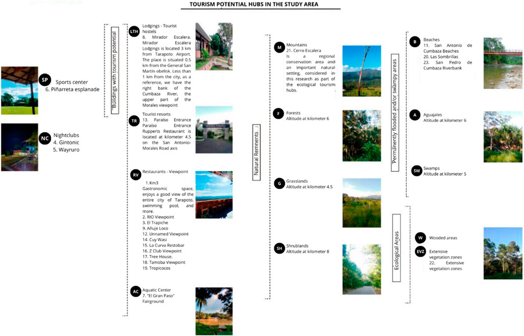
Figure 4. Tourism potential hubs in the study area. Note. Classification of hubs with tourism potential: buildings with tourism potential, natural remnants, permanently flooded and/or swampy areas, and ecological areas found in the Morales–San Antonio axis. Source 2. Self-made.
Consequently, as these areas are not identified for development as ecotourism hubs, the Amazonian landscape has been and will continue to experience alterations in the urban area, leading to loss of vegetation cover (Carranza Gallardo and Tasilla Montalván, 2020).
The locations at the national, regional, and zonal levels of the Morales–San Antonio route and the rapid urban growth of the area can be observed in detail in the map shown in Figure 4. Three different stages were determined to explain urban growth: over the past 54 years, the city has been taking the periphery in a horizontal sense. The city is characterized by its territory having much vegetation, but this vegetation is diminishing as a result of the sudden growth.
3.2 Hubs and landscape
3.2.1 Ecotourism hubs
Studies from institutions involved in research and tourism in the Peruvian jungle, such as the Peruvian Amazon Research Institute (IIAP) and the Regional Tourism Advisory Council (CCRT)-San Martín, among others, have recognized the existence of areas with tourist riches, leading to the development of methods aimed at defending and promoting diversity and ecotourism (DIRCETUR, 2021).
Similarly, the Urban Development Plan for the City of Tarapoto with its urban hubs, developed by the Municipalidad Provincial de San Martín, 2019, explains the cultural, environmental, and physical conditions that the city meets to be promoted as an ecotourism destination. It is enhanced as a tourist destination (Municipalidad Provincial de San Martín, 2019) with existing natural resources in the city.
Indicators of tourism hubs in the study area.
1. Tourist architecture, such as lodging, tourist recreation, restaurants, aquaculture centers, sports centers, and nightclubs, discarding residential buildings on the Morales–San Antonio axis.
2. Original areas of remaining natural vegetation with internal biodiversity.
3. Geographically delimited areas with ecological attributes enhancing their beauty for their prompt conservation.
4. Areas with possibilities of flooding, swampy areas, marshes, jetties, beaches, and those close to hydrographic basins.
Additionally, the city has ecotourism hubs, considering the characteristics of the area. These places and buildings with tourist potential (see Figure 4) are expressed as large expanses of vegetation, forests, water sources, and viewpoints, as indicated in their development plan for the years 2020–2029.
Indicators for ecotourism hubs (See Figure 2) and maps (See Figure 5) identified in the study area.
1. Buildings with tourism potential,
2. Natural remnants,
3. Ecological areas,
4. Permanently flooded and/or swampy areas.
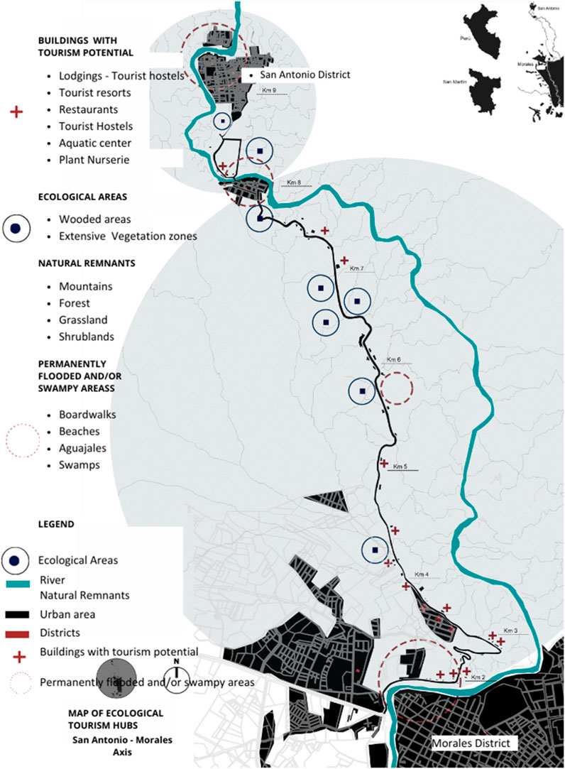
Figure 5. Route of buildings with tourism potential along the Morales–San Antonio axis. Source 3. Self-made.
The following map shows the tourism route and buildings with tourism potential along the Morales–San Antonio axis. Tourism indicators can also be seen: 1. Buildings with tourism potential, 2. Natural remnants, 3. Ecological areas, and 4. Permanently flooded and/or swampy areas. These places, determined as nuclei, are expressions of the great potential that this study area has. There is a variety of ecological and recreational areas with potential for the region between Morales and the San Antonio district.
This map shows the ecological tourism centers. A total of 23 centers were found, of which 10 are the most frequented by the population. Among them are, ecological areas, natural remnants, permanent places, and recreation centers, represented according to legend and identified by icons along the Morales–San Antonio route.
The map shows the changes that the study area has undergone, as well as the areas of vegetation that now serve as residential zones, many of which have completely deforested the so-called tourist centers. Throughout the route, it is possible to see the effect of real estate companies and how the city is populating these extensive areas of vegetation, which are known as the lungs of Tarapoto.
3.2.2 Sustainable urban landscape
3.2.2.1 Process of transformation of sustainable urban landscape
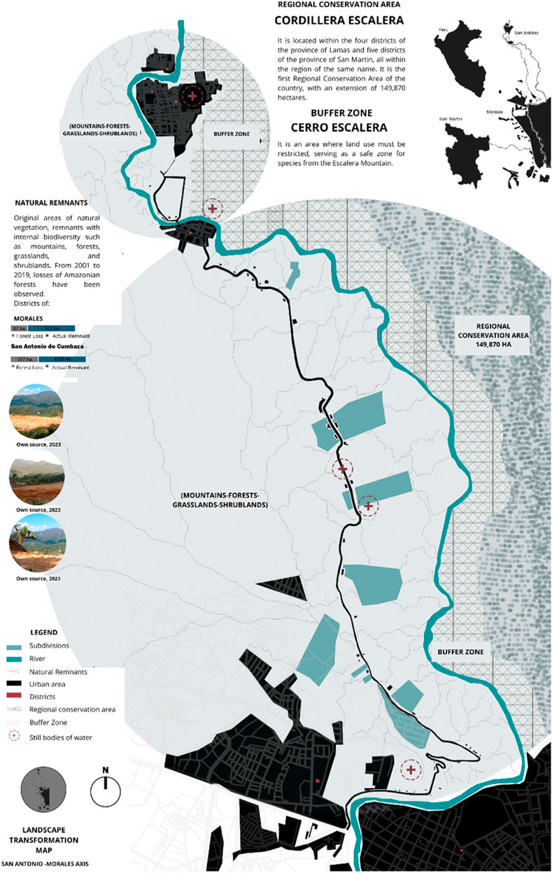
Losses of up to 87 ha of the total Amazon rainforest in the Morales district were observed in 2001–2019, leaving 342 ha. The most affected populated center between those years was San Antonio de Cumbaza, where the loss of up to 377 ha of natural forest occurred, leaving it with 4,229 ha of Amazon rainforest (Geobosque, 2020).
To date, many areas with these characteristics have been sold (see Figure 6), such as regional conservation areas, buffer zones, bodies of still water converted into subdivisions, and stripping areas that could have been protected for their intangible purpose (Rojas Briceño et al., 2019). Consequently, the visual appeal it once boasted will diminish. The natural mass in the city decreased from 75% to 35% in the years 2015–2019, leading to high thermal conditions, affecting the habitability of residents (Rondón Ramírez, 2017) Table 3.
3.3 Social tourism dynamics
3.3.1 Activities carried out by the population
The social tourism dynamics of people in the province of San Martín were investigated to understand the activities they engage in and to what extent sustainable tourism is of interest to them. Open interviews were conducted with 60 participants consisting of two international tourists, 18 national tourists, and 40 locals.
3.4.1.1 Sustainable tourism awareness
Both international actors interviewed were familiar with “sustainable tourism,” but only 37.5% of the local residents recognized the term.
3.4.1.2 In favor of sustainable tourism in the San Martín region
The data obtained from the interviewees show that the population is 100% in favor and 0% against this activity continuing to be promoted in the San Martín region.
3.3.1.3 Beneficial time range considered for ecotourism in the Morales–San Antonio axis
According to the 60 actors (67%) of the people interviewed believed that it took 3–4 h to enjoy tourism on the Morales–San Antonio route.
3.4.2 Activities typically undertaken in the Morales–San Antonio axis
Ten of the main activities carried out in the study axis were observed, among which bathing in the river act stands out, which obtained 17.0%, with the tenth place being camping and cycling, both hovering at 3%.
3.4.2.1 The most recommended tourism hubs to visit
The list of activities recommended by the interviewed actors highlights the edge of the river in the district of San Pedro de Cumbaza, a place people enjoy with their families. This activity is a cultural part of life in the Peruvian jungle.
3.4.2.2 Busiest days on the Morales–San Antonio axis
According to the interviewees, the busiest days within the axis are Sunday, Saturday, Friday, holidays, and in fifth place, Wednesdays.
4 Discussion
Based on the findings, we confirm the interrelation between urban landscape and tourism. In the results obtained from the study of the city and its urban growth over the years, Tarapoto boasts important ecological platforms with diverse landscapes that generate microclimates, improving the habitability of urban spaces. However, these are threatened due to the increase in peripheral urban sprawl, necessitating their conservation.
In this regard, Fernández Tabales and Santos Pavón (2018) mention that resolving such conflicts requires consideration of existing regulations to approach sustainable proposals that regulate the case. They propose ecotourism to ensure the conservation of natural landscapes in cities through the creation of hubs.
This demonstrates, first, that the growth of the city of Tarapoto can be addressed with the implementation of appropriate planning instruments and regulations that institutions need to consider. Also, Tarapoto already has potential urban hubs to generate ecotourism, such as Mirador Río, El Trapiche, Aguajales, Cordillera Escalera, the San Pedro de Cumbaza riverbank, and extensive vegetation areas at kilometer 6 Figure 7.
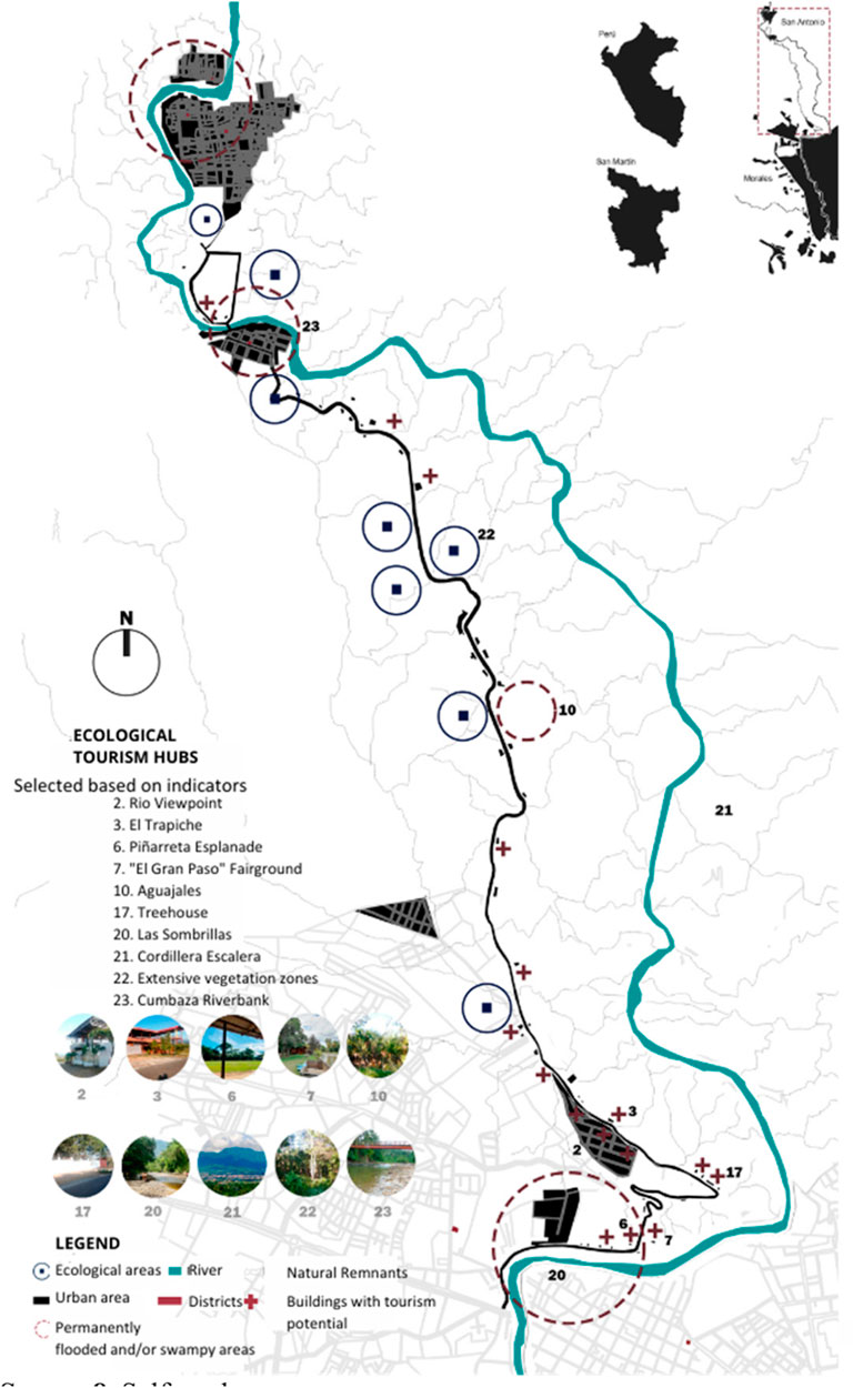
Figure 7. Identification of 10 buildings with tourism potential based on indicators. Source 8. Self-made.
In this sense, Briceño (2018) mentions that the visual and functional qualities of the urban landscape highlight attributes to improve the physical–spatial conformation, leveraging biodiversity, activities, specific characteristics in the indicators, and others. The city and its contribution to the urban landscape are expressed through the study of landscape attributes.
It can be seen that the Morales–San Antonio axis already has potential urban hubs to generate ecotourism, identified based on the indicators that the environment itself displays, highlighting both districts as significant settings within the territory of the San Martín region.
National studies define ecotourism through defined spaces as a sustainability alternative, preserving sectors with ecosystems of high value. Therefore, it is important to consider instruments that allow for their conservation, as the Morales–San Antonio articulating axis is currently undergoing a transformation in the sustainable landscape, resulting in the loss of large areas of green space. The research by Esparza et al. (2020) presents a worthy approach to tourist dynamics, aiming to provide benefits for the owners of the areas involved by implementing projects that contribute to the environment, increase its value, and protect natural green areas, thereby improving the quality of life of those involved. These results are related to what Gonzáles Mantilla and Neri (2015) affirm, proposing an architectural end that allows for the development of ecotourism. Likewise, we can see the great scenarios in the city, and appropriate measures from the authorities in charge can enhance what remains.
The final result obtained is about the tourist and social dynamics proposed to understand the activities in the study area by our three types of users, which is why we used open interviews. The open interview research technique revealed aspects of preferences from international tourists who recognize the places as ecological tourist attractions more than the locals, who only go for pleasure and habit. Similarly, Esparza et al. (2020) show the potential of instruments such as open interviews as a basis for understanding the thinking of actors regarding the categories analyzed in the methodology.
The field instrument provides useful data for social tourist dynamics. Additionally, it is demonstrated that not only buildings with tourism potential are the points of attraction but also permanently flooded and/or swampy areas such as beaches and riverbanks enhance tourism hubs. Many international and local tourists prefer riverbanks for bathing, making them places where there is greater activity and forming an axis among them.
5 Conclusion
This research concluded that the city of Tarapoto has ecological tourism centers and that these are articulated in the sustainable urban landscape of the Morales–San Antonio axis. These centers with tourist potential could promote the injection of tourist competitiveness and natural conservation in the city and, therefore, in the San Martín region.
Furthermore, the study delineated the perimeters and geomorphological patterns of these hubs to understand the articulation of sustainable urban landscapes in the Morales–San Antonio district. This was achieved through observation sheets, analysis of satellite images, design software, and geographic analysis. The identified indicators for tourism hubs in the study area were classified into four groups: buildings with tourism potential, natural remnants, ecological areas, and permanently flooded and/or swampy areas.
Indeed, Tarapoto boasts ecological tourism hubs characterized by extensive vegetation, forests, water sources, and viewpoints, as described in this research, contributing to tourism development plans in the city and its surrounding districts.
Additionally, the study interpreted the territory and its transition through landscape transformations, revealing the loss of Amazonian forest that particularly affects the San Antonio population center. Despite these discouraging figures, there has been an increase in recreational activities sought by the population of San Martín and tourists in the last 5 years. However, areas identified for tourism hub development, if not protected for the future, will experience alterations due to the loss of vegetation cover caused by urban growth, affecting the urban center of Tarapoto.
Understanding the social tourism dynamics of the population in the San Martín Province through municipal documents and interviews sheds light on the activities undertaken by the population. The data obtained from the interviewed actors highlight the tourist centers such as the San Pedro de Cumbaza River, Mirador Río, El Trapiche, Piñarreta Esplanade, and large areas of natural vegetation such as Cordillera Escaleras and Aguajales.
It was evident that the population is in favor of continuing to promote sustainable tourism in the San Martín region and that the main centers are protected because one of the activities carried out in the study area is bathing in the river, mentioned by 17.0% of the interviewees; therefore, if the remnants, buildings, ecological areas, and permanently flooded areas are lost, the social development of the San Martinense population would be affected.
Finally, the research had certain limitations. One was the lack of previous research on the tourism topic at the local and national level, an important point for the bibliographic review and background of the study. However, this study will be a contribution to government institutions and areas involved in the development of plans for the good of the population of Morales and San Antonio, as well as to students interested in this topic, suggesting that more research can be developed in order to revalue our natural spaces. In this sense and according to what was analyzed, it can be concluded that ecological tourism hubs articulate the sustainable urban landscape of the Morales–San Antonio axis.
Data availability statement
The original contributions presented in the study are included in the article/Supplementary Material; further inquiries can be directed to the corresponding author.
Author contributions
LM: conceptualization, data curation, formal analysis, funding acquisition, investigation, methodology, project administration, resources, software, supervision, validation, visualization, writing–original draft, and writing–review and editing. GN: conceptualization, data curation, formal analysis, funding acquisition, investigation, methodology, project administration, resources, software, supervision, validation, visualization, writing–original draft, and writing–review and editing. VE: conceptualization, data curation, formal analysis, funding acquisition, investigation, methodology, project administration, resources, software, supervision, validation, visualization, writing–original draft, and writing–review and editing. CL: supervision, validation, writing–original draft, and writing–review and editing.
Funding
The author(s) declare that financial support was received for the research, authorship, and/or publication of this article. This work was supported by the Peruvian Union University.
Conflict of interest
The authors declare that the research was conducted in the absence of any commercial or financial relationships that could be construed as a potential conflict of interest.
Publisher’s note
All claims expressed in this article are solely those of the authors and do not necessarily represent those of their affiliated organizations, or those of the publisher, the editors, and the reviewers. Any product that may be evaluated in this article, or claim that may be made by its manufacturer, is not guaranteed or endorsed by the publisher.
Supplementary material
The Supplementary Material for this article can be found online at: https://www.frontiersin.org/articles/10.3389/fbuil.2024.1452528/full#supplementary-material
References
Álvarez Calixto, E. J., Rincón Carreño, K. S., and Ropero Duran, Y. (2020). El impacto ambiental de la gestión de las constructoras. Available at: https://formacionestrategica.com.10
Arévalo, S., and León, F. (2017). Propuesta de equipamiento urbano de la localidad de Tarapoto provincia de San Martin Región San Martín. Univ. Nac. San Martín Tarapoto 1. Available at: http://repositorio.unsm.edu.pe/handle/11458/574.
Babii, A., and Nadeem, S. (2021). El turismo en el mundo tras la pandemia. Fondo Monet. Int. Available at: https://www.imf.org/es/News/Articles/2021/02/24/na022521-howto-save-travel-and-tourism-in-a-post-pandemic-world.
Briceño, M. (2018). Paisaje urbano y espacio público como expresión de la vida cotidiana. Rev. Arquit. 20 (2), 10–19. doi:10.14718/revarq.2018.20.2.1562
Carranza Gallardo, J., and Tasilla Montalván, F. E. (2020). Pérdida de cobertura vegetal en el distrito de Morales, San Martin, Perú (periodo 1987 – 2017). Rev. Investig. Cienc. Tecnol. Desarro. 6 (1), 1–11. doi:10.17162/rictd.v6i1.1400
DIRCETUR (2021). Turismo regional. Available at: https://www.gob.pe/regionsanmartin-dircetur.
Dirección de Gestión Ambiental (2021). Plan Regional de acción ambiental alineado a la INDC. Available at: https://sinia.minam.gob.pe/documentos/plan-regional-accion-ambiental-alineado-indc-2017-2021.
Dirección Regional de Comercio y Turismo [DIRCETUR]. (2019). Plan Estratégico Regional de Turismo - Pertur San Martín 2019-2030.
Enshassi, A., Kochendoerfer, B., and Rizq, E. (2014). Evaluación de los impactos medioambientales de los proyectos de construcción. Scielo. Available at: https://www.scielo.cl/scielo.php?script=sci_arttext&pid=S0718-50732014000300002.
Esparza, R., Gamarra, C., and Daysy, B. (2020). El Ecoturismo como reactivador de los emprendimientos locales en áreas naturales protegidas. Rev. Univ. Soc. 12 (4), 436–443. Available at: http://scielo.sld.cu/pdf/rus/v12n4/2218-3620-rus-12-04-436.pdf.
Ezaquias, J. E. (2022). LA GESTIÓN DEL ECOTURISMO COMO VÍA DE CONTRIBUCIÓN AL DESARROLLO LOCAL DE CUANDO CUBANGO, ANGOLA. Ciencias Adm. (20), 107. doi:10.24215/23143738e107
Fernández Tabales, A., and Santos Pavón, E. (2018). La difícil convivencia entre paisaje urbano y turismo: clasificación de conflictos y propuestas de regulación a partir del análisis comparativo de normativas locales. Bol. La Asoc. Geógr. Españoles 0 (78), 180–211. doi:10.21138/bage.2715
Fuller, N. (2011). REFLEXIONES SOBRE EL TURISMO RURAL COMO VIA DE DESARROLLO, El caso de la comunidad de Antioquía, Perú. Perú. Available at: https://www.scielo.org.ar/scielo.php?script=sci_arttext&pid=S1851-17322011000400010.
Gambarota, D. M., and Lorda, M. A. (2024). El turismo como estrategia de desarrollo local. Available at: https://www.redalyc.org/jatsRepo/3477/347753793006/html/index.html58, 346–359.
Geobosque (2020). Bosques y pérdida de bosques. Available at: http://geobosques.minam.gob.pe/geobosque/view/perdida.php.
Guevara, G., Verdesoto, A., and Castro, N. (2020). Educational research methodologies (descriptive, experimental, participatory, and action research). Rev. Científica Mundo La Investig. El Conoc. 0 (3), 163–173. doi:10.26820/recimundo/4.(3).julio.2020.163-173
Guevara Alban, G. P., Verdesoto Arguello, A. E., and Castro Molina, N. E. (2020). Metodologías de investigación educativa (descriptivas, experimentales, participativas, y de investigación-acción). Recimundo Rev. Científica La Investig. El Conoc. 4 (3), 163–173. doi:10.26820/recimundo/4.(3).julio.2020.163-173
Hernández Ramírez, J. (2020). El turismo y la construcción de los paisajes urbanos. Disparidades. Rev. De. Antropol. 75 (1), 001. doi:10.3989/dra.2020.001d
Hernández Sampieri, R., Fernández Collado, C., and Baptista Lucio, M. (2014). Metodología de la investigación. Available at: https://www.esup.edu.pe/wp-content/uploads/2020/12/2.%20Hernandez,%20Fernandez%20y%20Baptista-Metodolog%C3%ADa%20Investigacion%20Cientifica%206ta%20ed.pdf.600
Leal Londoño, M., and del, P. (2017). Turismo ecológico y sostenible: perfiles y tendencias. Grupo Investig. Interdiscip. GRIT-OSTELEA 0, 1–45. Available at: http://www.aept.org/archivos/documentos/Informe_TurismoEcologico.pdf.
Mercado Alonso, I., and Fernández Tabales, A. (2016). La percepción social del paisaje urbano como indicador de sostenibilidad turística. El caso de Sevilla. Monogr. La Soc. d’Historia Nat. Les Balears, 2016-Janua 23, 131–142. Available at: https://dialnet.unirioja.es/servlet/articulo?codigo=6392271.
Municipalidad Provincial de San Martín (2019). Plan de Desarrollo Urbano de la Ciudad de Tarapoto [PDU] 2019-2029. Plan Desarro. urbano la Ciudad Tarapoto 2019-2029. Available at: https://mpsm.gob.pe/public/uploads/documentos/pdu-2019-2029.pdf.
Organización Mundial del Turismo [OMT] (2022). El Turismo crece Un 4% en 2021, muy por debajo aún de los niveles prepandémicos. En. Tur. 34.
Rodríguez Martínez, M., Ramírez Pérez, J. F., and Pérez Hernández, I. (2020). Turismo local sostenible en áreas forestales: una aproximación teórica. Scielo Cooperativismo Desarro. 8 (1). Available at: http://scielo.sld.cu/scielo.php?script=sci_arttext&pid=S2310-340X2020000100083.
Rojas Briceño, N. B., Barboza Castillo, E., Maicelo Quintana, J. L., Oliva Cruz, S. M., and Salas López, R. (2019). Deforestación en la Amazonía peruana: índices de cambios de cobertura y uso del suelo basado en SIG. Bol. La Asoc. Geógr. Españoles 0 (81), 1–34. doi:10.21138/bage.2538a
Rondón Ramírez, G. (2017). Los territorios hidro sociales de la ciudad de Lamas (San Martín, Perú): agua, sociedad y poder. Espac. Desarro. 108 (29), 91–108. doi:10.18800/espacioydesarrollo.201701.004
Saeteros Hernández, A. M., Da Silva, E. V., and Flores Sánchez, M. A. (2019). Turismo sustentable y los diferentes enfoques, aproximaciones y herramientas para su medición. Rev. Tur. Patrim. Cult. 17 (5), 901–914. Available at: https://www.redalyc.org/journal/881/88165933011/html.
Tudela Mamani, J. W., Cachui Cachui, E., and Aliaga Melo, G. (2022). Impacto del COVID-19 en la demanda de turismo internacional del Perú. Una aplicación de la metodología Box-Jenkins. Revista de Investigaciones Altoandinas – J. High Andean Res. 24 (1), 36. doi:10.18271/ria.2022.31
UICN (2022). Posicionar el turismo como herramienta de conservación en un mundo post COVID en el Perú. Gl. Suiza. Obtenido Available at: https://iucn.org/sites/default/files/2023-02/notatecnica-turismososteniblepostcoviddis_compressed_compressed_0.pdf.
Keywords: tourism, urban landscape, sustainable development, natural resources, sustainable tourism
Citation: Miguel Mesias LR, Nahún GG, Estaylor Marcelino VR and Luisa Enith CP (2024) Ecotourism hubs as an articulator of sustainable urban landscape in Morales–San Antonio. Front. Built Environ. 10:1452528. doi: 10.3389/fbuil.2024.1452528
Received: 21 June 2024; Accepted: 30 September 2024;
Published: 13 December 2024.
Edited by:
Assed N. Haddad, Federal University of Rio de Janeiro, BrazilReviewed by:
José Ramón Cardona, University of the Balearic Islands, SpainAna Catarina Evangelista, Engineering Institute of Technology (EIT), Australia
Copyright © 2024 Miguel Mesias, Nahún, Estaylor Marcelino and Luisa Enith. This is an open-access article distributed under the terms of the Creative Commons Attribution License (CC BY). The use, distribution or reproduction in other forums is permitted, provided the original author(s) and the copyright owner(s) are credited and that the original publication in this journal is cited, in accordance with accepted academic practice. No use, distribution or reproduction is permitted which does not comply with these terms.
*Correspondence: Chafloque Pinedo Luisa Enith, bWlndWVsLmxlb25AdXBldS5lZHUucGU=
 Leon Ruiz Miguel Mesias
 Gil Gonzales Nahún
 Vilchez Ramos Estaylor Marcelino
 Chafloque Pinedo Luisa Enith

