 Haya M. Alogayell1
 Ahmed Kamal
 Rasha H. Ramadan
94% of researchers rate our articles as excellent or good
Learn more about the work of our research integrity team to safeguard the quality of each article we publish.
Find out more
ORIGINAL RESEARCH article
Front. Built Environ., 12 June 2024
Sec. Urban Science
Volume 10 - 2024 | https://doi.org/10.3389/fbuil.2024.1379269
Our study meticulously pursued its objectives through a strategic data-gathering approach and a thorough analytical evaluation. In the data collection phase, we undertook an exhaustive accumulation of geographical and environmental information, utilizing high-resolution satellite images and diverse thematic maps. We employed GIS-based models and the Analytical Hierarchy Process (AHP) to effectively determine the most suitable areas for urban development. These models pinpointed zones along the coastal areas and nearby plains, spanning 198.89 square kilometers or 8.25% of the total study area, as highly appropriate for development due to their potential for desalination and tourism, and proximity to vital infrastructure such as the forthcoming NEOM airport and high-speed railway connections. The findings from the Southwestern NEOM model corroborate with NEOM’s strategic goals, especially validating the chosen location for The Line. This location is considered ideal due to its accessibility, terrain suitability, and capability to incorporate renewable energy and sustainable water management, thereby supporting the strategic aims and placement of the initiative. This not only highlights the strategic positioning of these areas but also aligns with the Saudi Vision 2030, fostering economic diversification and sustainable development. Together, these actions have established a comprehensive framework for urban planning that respects environmental conservation and promotes sustainable development objectives. By incorporating socio-economic and cultural factors, our research offers a well-rounded approach to urban development, ensuring that new infrastructure is both environmentally considerate and strategically situated to promote enduring growth and community wellbeing in Southwestern NEOM.
Initiated by the Saudi government on 24 October 2017, the NEOM Region initiative stands as a symbol of commitment to development. It aligns with global efforts to transform urban environments for the 21st century. This project is part of a worldwide trend where countries are shaping the future of urban living, with Saudi Arabia positioning itself as a leader in this arena by leveraging its unique cultural heritage and drawing parallels with other international endeavors such as Dongtan in China, Egypt’s Smart Village, and Masdar City in the UAE (Powell, 2022). NEOM is envisioned as a hub of innovation and environmental stewardship, setting a new benchmark for regional development that aligns with sustainability goals embraced by global megacities (Brochure, 2018).
The goal of sustainable urban development, especially in challenging environments, is a common theme across various global projects, including NEOM (Aina, 2017). Projects like Masdar City in the UAE have been pioneers since 2006, focusing on a zero-carbon and zero-waste ecosystem powered by renewable energy (Sankaran and Chopra, 2020), and employing traditional design methods for natural cooling and energy efficiency (Yusuf and Abdulmohsen, 2022), a contrast to NEOM’s high-tech urban design. Dongtan in China aims for a self-sufficient, minimal-impact eco-city that blends urban and rural elements (Wang and Mell, 2019), sharing NEOM’s sustainability ambitions but with a greater focus on agricultural integration (Yusuf and Abdulmohsen, 2022). The Smart Village in Egypt, while reflecting NEOM’s tech-driven business environment outside Cairo, does not share NEOM’s extensive urban ecosystem aspirations (Abusaada et al., 2023).
Moreover, NEOM aligns with global development agendas by UN-affiliated organizations that advocate for sustainable urbanization and tackle essential issues like poverty, healthcare, and environmental sustainability (Boelt, 2014). Urban development in desert areas presents unique challenges such as water scarcity, harsh climates, environmental conservation, and the need for sustainable resource management (Ramadan and Effat, 2021; Alogayell et al., 2024). Strategies to address these include desalination, water recycling, and rainwater harvesting for water scarcity (Alkhalidi et al., 2018; Amr, 2023) innovative architecture and renewable energy to cope with extreme climates (Günel, 2019; Kutty et al., 2023) environmental conservation efforts to protect biodiversity and prevent ecological degradation (Sankaran and Chopra, 2020; Ramadan R. H. et al., 2022; Effat et al., 2022) and the development of durable infrastructure designed to withstand desert conditions (Riadh, 2022).
The application of Geographic Information Systems (GIS) for planning and land use analysis is essential, aiding in making informed urban planning decisions that consider social, economic, and environmental impacts (GIS) (Taiema and Ramadan, 2021; Mishra, 2023). GIS-based analysis has proven invaluable in mapping and analyzing land use suitability for different uses, determining ecological habitats, assessing geological and agricultural suitability, and evaluating landscapes for planning and services (Abdullahi et al., 2015; AbdelRahman et al., 2016; González-Méndez et al., 2021; Ramadan M. S. et al., 2022; Hakam et al., 2023; Lötz, 2023; Rana and Moniruzzaman, 2023; Watuwaya et al., 2023).
This research uses Remote Sensing technology and GIS to explore development opportunities in the Southwestern NEOM region in Saudi Arabia, identifying ideal locations for urban development by considering many parameters such as Land Use-Land Cover, Slope, Faults, High order stream, Geologic map, Quarries, Power supply, Water Supply, Industrial areas, Incinerators, Tourist sites, and Roads. Our GIS-based model, enhanced by the Analytical Hierarchy Process (AHP), offers a comprehensive method for sustainable urban planning in arid regions, addressing the specific challenges of desert urban development. This approach helps advance the development of inclusive, safe, resilient, and sustainable urban areas, contributing to Sustainable Development Goal 11. Our recommendations focus on designing and planning strategies that prioritize conservation and efficiency, aiming to minimize environmental impacts while enhancing the preservation of natural habitats. This research seeks to map strategic development areas in Southwestern NEOM and supports the vision of nurturing thriving communities within Saudi Arabia’s desert landscapes.
The Southwestern region of NEOM covers an area of 3160 km and includes the Tabuk and Duba governorates, along the coast of the Red Sea (Figure 1). It is bounded by latitude coordinates 27°45′18″N 27°48′31″N and longitude coordinates 35°12′34″E, 36°23′50″E. This area has a plain landscape with wadi systems that flow from hills and mountains towards the sea. There has been limited development apart from villages, which presents opportunities for growth and expanding infrastructure connected by recently built highways. The region’s varied terrain, untapped resources, and proximity to the Red Sea make it strategically important for both conservation efforts and development in line with Saudi Vision 2030 goals (Salman, 2024). However, there is a need for suitability modeling to identify areas, for urban growth that align with these goals.
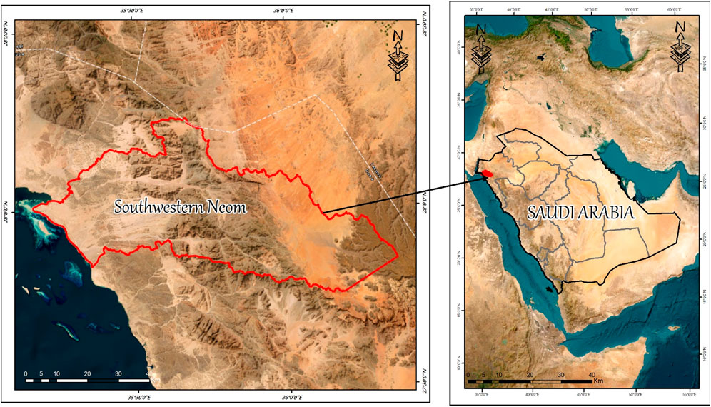
Figure 1. Location of the study area.
In our extensive study, we meticulously investigated several key elements such as land utilization, agricultural zones, urban development, and water resource management. Our analysis predominantly relied on the detailed review of satellite imagery:
We sourced high-resolution satellite imagery of the NEOM region from the Sentinel-2 satellite, captured in 2024 with a 10-m resolution. This imagery was instrumental in offering an exhaustive visual overview of the area. To enhance data accuracy, we applied the FLAASH module within ENVI 5.1 software to correct any atmospheric distortions. We also implemented Mosaicking techniques to amalgamate various satellite scenes into a seamless image. For image classification, we employed the Support Vector Machine (SVM) model, successfully segregating the unified images into clear categories like land, urban areas, water bodies, and desert regions, using the ENVI 5.1 software for this sophisticated task.
Data from the Shuttle Radar Topography Mission (SRTM) was crucial for creating the Digital Elevation Model (DEM), which offers a 30-m resolution. This data shed light on the terrain’s physical characteristics, such as elevation changes, slope gradients, orientations, and the complex patterns of water streams. This detailed dataset was processed using the ESRI Spatial Analyst toolkit, greatly enhancing our understanding of the terrain features.
Further insights into the NEOM region were derived from thematic maps provided by specialized agencies (as listed in Table 1). These maps, originally in hard copy, underwent a digital conversion process involving scanning, imperfection corrections, and transformation into a digital format using ArcGIS 10 software. This process converted the maps into shapefiles, subsequently stored in a database for in-depth analysis and exploration. By integrating advanced satellite imagery with detailed topographical data and digitized thematic maps, we laid a solid foundation for a comprehensive understanding of the Southwestern NEOM region’s geographical and environmental attributes. This approach enabled a detailed examination of land use trends, agricultural capacities, potential urban development areas, and water resources, which are vital for effective planning and sustainability evaluations in the ongoing development of the Southwestern NEOM region.
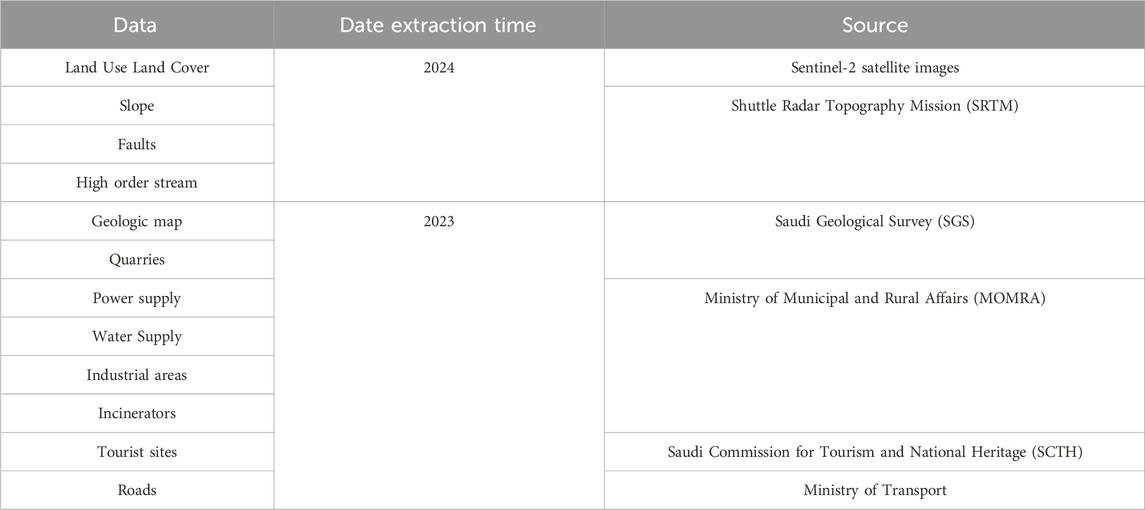
Table 1. Data sources.
In our study, Figure 2 displays a diagram that illustrates the applied analysis methods used to assess the geographical and environmental data of the Southwestern NEOM region.
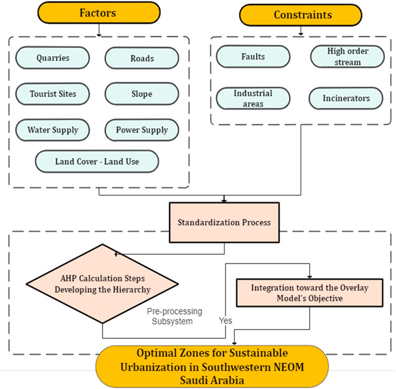
Figure 2. A structured workflow for the Methodology Applied.
Creating selection criteria at the beginning of the spatial decision-making process is crucial, especially in the areas of urban planning, environmental preservation, and land use. This initial step involves a detailed analysis of both academic research and expert insights to develop a comprehensive list of factors and constraints that shape the decision-making process. This list is formulated based on a thorough review of scholarly works and consultations with field experts (Aminu, 2007; Govindan et al., 2016; Saqr et al., 2021; Tiwari et al., 2024), ensuring the criteria are grounded in both theory and practical application.
Constraints are vital within the criteria framework as they highlight regions that are excluded from further analysis. These areas often encompass ecologically sensitive zones, already developed regions, or legally protected territories. By setting these constraints, the analysis is refined to focus only on areas that are suitable for development.
In contrast, factors are used to evaluate the potential of areas based on specific measures of suitability. These measures relate to sustainable development goals and may include aspects like environmental impact, availability of resources, and socio-economic advantages (van Herwijnen et al., 1993; Yang et al., 2008). The primary aim of using these criteria is to promote sustainable development by seeking harmony among economic growth, environmental conservation, and social fairness (Keshkamat et al., 2009). This integrated approach ensures that the chosen sites are aligned with broader long-term objectives for community wellbeing.
In the upcoming section, we will explore the various factors that informed the model’s creation.
In emerging regions, prioritizing the use of potential land resources is key for generating employment opportunities. A critical element in assessing land resource availability is the presence of quarries and mines, which are indispensable for many activities. Neom, for instance, boasts mineral resources such as coal, black sands, glass sand, and kaolin, as well as construction materials like marl, dolomite, sand, gravel, marble, and granite. Essential to the cement industry are resources like limestone, shale, and gypsum. The data for this analysis were provided by the Saudi Ministry of Petroleum and Mineral Resources through a mineral resources map.
The theme of Accessibility is central to urban planning, stressing the importance of robust infrastructure for the seamless operation of urban areas. This theme influences many facets, including transport logistics and utility services. Roads are vital as they enable the movement to and from development sites and connect various regions, which is crucial for residential and commercial functions (Dastgoshade et al., 2024). The main focus was on mapping roads, routes, and tracks across desert areas, using data from the Ministry of Transport. This data was digitized to ensure a detailed understanding of current access and to help plan future developments strategically.
The economic sustainability of urban development projects is vital, factoring in initial costs, job creation, and regional economic growth (Du et al., 2023). Economic feasibility significantly influences site selection, ensuring the chosen site meets current and future economic demands and supports sustainable growth. Understanding land cover and land use is crucial as it highlights development constraints and opportunities. Areas such as reserves, agricultural lands, and urban zones are often designated to remain unchanged due to their current use or importance (Borana and Yadav, 2023). Land cover layers are created using advanced classification techniques on Sentinel 2 satellite images, identifying categories like water bodies, vegetation, deserts, and urban areas to guide development planning.
Proximity to existing power infrastructure, such as high-voltage lines or power stations, is crucial for site selection due to its economic implications. The high solar radiation in desert areas presents a unique opportunity to harness renewable energy sources (Asakereh et al., 2017), reducing reliance on fossil fuels and promoting sustainable development. This mapping used data from topographic maps, offering key insights for choosing sites based on energy resource proximity.
The scarcity of water in areas like NEOM poses significant challenges to sustainable urban growth. Access to water resources is a fundamental aspect of planning (Marinou, 2020; Aklan et al., 2023), crucial for residential, commercial, and agricultural needs. The potential for seawater desalination is considered, using a distance module to measure proximity to the coastline and evaluate the feasibility of this option for the region’s water strategy.
Slope evaluation was performed using the Shuttle Radar Topography Mission (SRTM) digital elevation model (DEM) within the ESRI ArcGIS 10.3 framework. Areas with slopes steeper than 25° were deemed unsuitable for development due to risks like land collapse (Zhang et al., 2023).This criterion helps identify and exclude locations where steep terrains could pose construction challenges or long-term stability risks.
Preserving historical sites and maintaining their land-use integrity is crucial (Alsubeh and Helmi, 2024). Data from the Saudi Commission for Tourism and National Heritage (SCTH) was used to categorize lands with a focus on protection; areas marked as protected were given a zero value, signifying their exclusion from development plans. Additionally, a 500-m buffer zone around these sites was also marked with a zero value, setting these areas apart as off-limits for development, thus protecting cultural and historical assets while informing urban planning choices.
In the Southwestern NEOM project’s site selection for urban development, the formulation of a constraints map is crucial for pinpointing and excluding areas that are sensitive and pose risks. These constraints, often depicted through buffered zones among other indicators, are essential for carrying out sustainable development assessments within NEOM’s planning strategies. Given the vulnerability of desert ecosystems, it is critical for urban development efforts to minimize environmental impacts, thus preserving biodiversity and natural resources (Fischer, 2023). This approach ensures that development proceeds with a deep respect for ecological sensitivities, effectively mitigating environmental impacts and adhering to sustainability principles by steering clear of areas with ecological, geological, or social vulnerabilities.
To determine the zones to be avoided in development, we created a map outlining these constraints (as outlined in Table 2). The evaluation of constraints was then performed using inverse data from a hazard map, which helped guide the decision-making process away from areas that are potentially unstable or unsuitable for development.
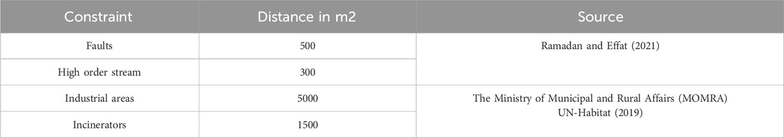
Table 2. Constraints sources.
The creation of a constraints map involves converting vulnerability index scores into stability indicators through an inverse calculation method. This method, essentially calculating the reciprocal of the vulnerability score, provides a refined assessment of land stability based on key considerations.
These zones are identified as being at risk due to pollution from industrial activities. The Ministry of Municipal and Rural Affairs (MOMRA) is instrumental in setting buffer zones around these areas to minimize their impact. A comprehensive listing of these zones is detailed in Table 2, supported by references from existing studies.
Areas intersected by geological fault lines are inherently riskier, with a higher likelihood of land collapse due to the instability these faults cause. Pinpointing these zones is vital for accurate land vulnerability assessments.
The suitability of land for development varies with its geological makeup; distinguishing between clayey and rocky terrains is crucial. Clayey terrains are typically less stable structurally, whereas rocky terrains, although more stable, might increase infrastructure development costs. This differentiation, emphasized by (Golany, 1983), underlines the necessity of considering geological factors in urban planning.
Regions with a dense network of streams are at increased risk for land collapse. The presence of numerous streams can be indicative of potential erosion and waterlogging problems, both of which are critical factors in assessing constraints.
By examining these elements, the constraints map becomes an indispensable resource for urban planners and developers, aiding in the decision-making process to ensure that development is both secure and sustainable and focused on protecting environmentally sensitive regions. It also underscores the necessity of steering clear of already-developed areas, as shown in (Figure 3).
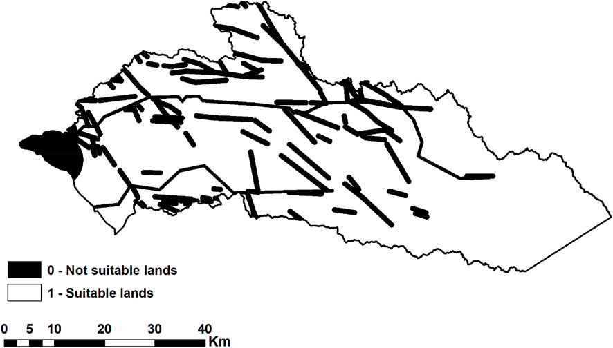
Figure 3. Constraints map.
To maintain the reliability of our analysis, standardizing the measurement scales for various attributes is crucial. This process adjusts the attributes to a uniform scale, ensuring they are measured accurately and are relevant to our specific needs in analysis or application contexts. We focus on areas such as land use, agricultural potential, urban development possibilities, or environmental protection.
1. Definition of Rating Scale: Establish a rating scale from 1 to 9 for each attribute, considering different factors. A higher score indicates a more favorable or suitable condition for the attribute, allowing for a nuanced assessment of each factor’s contribution to the overall objectives.
2. Unsuitability Coding: Assign a zero value to pixels or areas that do not meet the established criteria for suitability. This binary coding method distinctly marks these areas as unsuitable, removing them from further suitability evaluations and focusing analysis on regions with potential for development or utilization.
3. Process of Standardizing Attributes (refer to Table 3):
➢ Attribute Identification: Begin by pinpointing all relevant attributes necessary for the analysis. This may involve factors such as soil quality, water resources, proximity to urban areas, elevation, and slope for land use and agricultural evaluations, or infrastructure and environmental considerations for urban planning.
➢ Quantitative Evaluation: Conduct a quantitative analysis for each attribute based on its importance or relevance to the main goals. For example, in evaluating agricultural lands, soil fertility might be prioritized over slope.
➢ Rating Scale Application: Apply the 1 to 9 rating scale to these quantitative assessments. Attributes that align closely with the analysis goals receive higher scores, reflecting their advantageous characteristics.
➢ Integration into the Overall Analysis: Once scores are assigned to all attributes, integrate these standardized ratings into the broader analytical framework. This integration typically involves using a geographic information system (GIS) for spatial analysis, where each pixel’s suitability is determined by the combined scores of its attributes, enabling a detailed evaluation of suitability across different landscapes.
4. Applications of Standardized Attributes in Decision Making:
➢ Spatial Suitability Models: In the context of Geographic Information Systems (GIS), standardized attributes facilitate the creation of spatial suitability models. These models graphically display areas ranked from most to least suitable for specific uses.
➢ Weighted Overlay Analysis: This technique involves assigning weights to different attributes based on their relative importance and combining them to form a comprehensive suitability map. It is especially valuable in complex scenarios that require consideration of multiple contributing factors.
5. Conclusion and Presentation of Results: The process of standardization and subsequent analysis culminates in the production of maps or models that categorize areas by their suitability levels, ranging from highly suitable (scores near 9) to completely unsuitable (scored as zero), as illustrated in (Figure 4). These visual tools are instrumental in guiding decisions in sectors like urban planning, environmental management, and agricultural expansion, directing resources toward areas with the greatest potential for success.
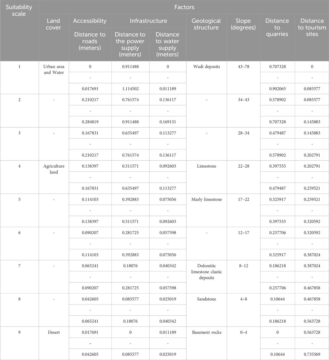
Table 3. Standardization of themes.
Figure 4. Standardized Factors Map: (A) Land Cover; (B) Distance to Roads; (C) Distance to Quarries; (D) Distance to the Power Supply; (E) Distance to the Water Supply; (F) Geological Structure; (G) Slope; (H) Distance to Tourism sites.
To determine the relative significance of different factors in selecting urban development sites, we applied the Analytical Hierarchy Process (AHP), as described by (Saaty, 1977). This approach uses pairwise comparisons within a structured matrix, the size of which is determined by the number of criteria evaluated. We established a comparison matrix and thoroughly assessed each pair of criteria to compute a priority vector (Wj) that indicates the relative importance of these factors, ensuring consistency in our evaluations (Sharma et al., 2022). These comparisons were scaled from 1 to 9, as indicated in Table 4.
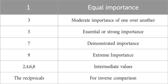
Table 4. Pairwise comparison matrix (data from Saaty, 1977).
Based on the guidance of (Bailey, 2005) and through exhaustive literature reviews, we developed a pairwise comparison matrix, depicted in Table 5, where the weights are labeled as “aij”. For instance, a weight of a23 = 3 suggests that the third attribute is three times as significant as the second, with its reciprocal a32 = 1/3 showing the reverse relationship. We normalized the matrix values by dividing each judgment by the sum of its column, then derived the priority vector by averaging these normalized values across rows. This vector was further normalized to accurately represent the weights of all factors (Wj). The subsequent steps included.
1) Calculating the weighted sum vector by multiplying the comparison matrix with the priority vector, normalizing each resultant value, and then aggregating these to obtain an overall weighted sum.CI = (λ − n)/(n − 1)
2) Estimating the consistency vector and computing both lambda (λ) and the consistency index (CI) to assess the coherence of our pairwise comparisons. Lambda represents the sum of the components of the consistency vector and serves as a consistency benchmark, with perfect consistency achieved when λ equals the number of criteria, n.CR = CI RI

Table 5. CI index (data from Saaty, 1977).
The CI offers a normalized measure of inconsistency, essential for assessing the reliability of our evaluations (Saaty, 1994), as shown in Table 5.
To effectively synthesize data in our overlay analysis, it is crucial to integrate all input factors to identify the most suitable locations according to our model’s objectives. We utilized a weighted summation approach to determine which areas are more favorable for development, based on the output raster generated. We created a suitability index for different zones using a weighted overlay method, which combines maps of various criteria. In this procedure, each factor (j) is assigned a specific weight (Wj), and scores (Xij) are allocated to assess their importance. Additionally, we included Πcl, a map displaying symbols, to enhance our analysis, ensuring a thorough assessment of all variables involved in determining the most appropriate locations for development.S = (Wi ⋅ Xij) ∗ Πcl
The factor weights were calculated using the Analytical Hierarchy Process (AHP), as shown in Table 6.

Table 6. Pairwise Comparison Weight Matrix for factors.
Integrating various factors critical to site suitability is vital for achieving the overall goal of the overlay analysis. This process brings together diverse elements to ensure that the final site selection adheres to the principles of sustainability across social, economic, and environmental dimensions, as illustrated in (Figure 5). This integrated approach is essential for a comprehensive assessment that supports informed decision-making.
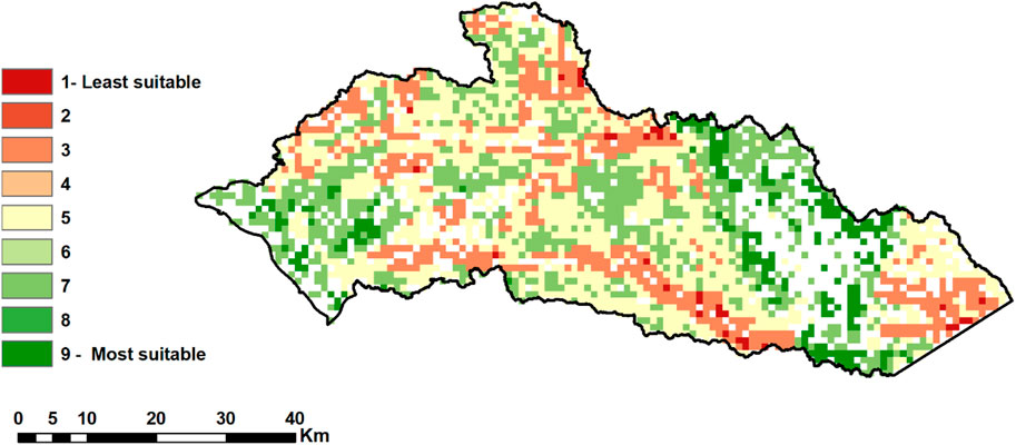
Figure 5. Final weighted linear combination.
The detailed spatial survey spans 872.68 square kilometers, accounting for 36.21% of the entire study area, as specified in Table 7 and depicted in Figure 6. This coverage highlights the significance of these zones in achieving the urban development objectives of the Southwestern NEOM project.
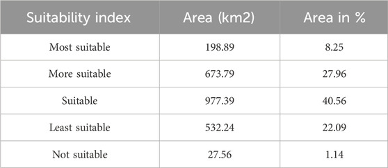
Table 7. Suitability categories areas in Km2.

Figure 6. Most suitable zones for urban development in Southwestern NEOM region.
The analysis identifies promising locations for development primarily along the coastal regions and adjacent plains, shown in Figure 6, with 8.25% of the land receiving a high suitability rating of above 0.7. This discovery supports our aim to pinpoint areas for strategic growth while taking into account environmental and socioeconomic considerations. The proximity to the coast increases the attractiveness of these areas, offering advantages such as access to maritime ports, transport networks, and the potential for desalination and tourism industries. However, the analysis recommends a careful assessment of potential environmental repercussions from development activities.
Inland areas demonstrate moderate development suitability, with scores between 0.4 and 0.7, with 49.23%, particularly along established transportation arteries. This suggests opportunities for expansion beyond the main coastal areas. Variables like terrain incline and proximity to protected wadis are factored into the suitability assessments, indicating a lower potential for development in these regions if sustainability is prioritized. Nevertheless, these elements should be interpreted not only as restrictions but as aspects that necessitate thoughtful planning and decision-making to promote sustainable growth. For example, while challenging terrain might initially limit development, innovative engineering approaches could mitigate these difficulties. Similarly, conservation zones may restrict certain developments but can increase an area’s appeal through ecotourism and strategically planned access points.
This suitability analysis provides an essential evidence-based framework for policymakers, facilitating a balance between development ambitions, technological capacities, and environmental constraints. The analysis aids in promoting development in highly suitable areas and in guiding comprehensive planning in areas with lower suitability. This ensures that dialogue among communities, developers, and regulators is informed and aligned, fostering coordinated development initiatives that account for both social and environmental longevity.
The analysis further emphasizes the strategic positioning of suitable areas close to upcoming infrastructural developments like the NEOM airport and planned high-speed railway links. These areas are ideally suited for both commercial and residential projects, likely to develop into dynamic urban hubs. They ensure convenient access to basic utilities and renewable energy sources, especially solar power projects, aligning with NEOM’s vision for sustainable energy usage. This proximity also supports economic, industrial, and technological advancement in Southwestern NEOM, promoting economic growth, job creation, and innovation.
The chosen sites not only enjoy advantageous geographical features and access to vital water resources such as underground aquifers and prospective desalination locations but also show a dedication to sustainable water management, critical for the area’s development. The planning process incorporates ecological considerations by integrating buffer zones and green corridors to maintain the ecological health of Southwestern NEOM. Furthermore, the selection of areas with favorable microclimates enhances passive cooling, optimal ventilation, and efficient solar power utilization, exemplifying a proactive stance toward establishing sustainable, comfortable urban spaces.
The comprehensive spatial analysis demonstrates Southwestern NEOM’s potential as a leader in sustainable urban development. The carefully chosen zones are well integrated with the coastal and foothill landscapes, reflecting a meticulous planning process committed to balancing development with environmental preservation and cultural heritage protection. This approach enables Southwestern NEOM to meet economic and social goals while protecting and enriching the region’s natural and cultural assets for the future.
The analysis took into account the importance of preserving cultural heritage sites and assets, by creating protected buffer zones. Areas close to 60 mapped historic sites were given lower rankings for development suitability. It is crucial to preserve these spaces and remnants of ways of life in order to maintain our cultural sustainability in the face of rapid modernization plans.
These findings also have implications for the Bedouin communities that inhabit the inland western coasts of Tabuk and rely on valuable Wadi (valley) systems as stated by MOMRA in 2023. The model ensured that there was no encroachment on Wadi networks which are vital for their livelihoods. It is crucial to engage in planning to uphold land use rights and ensure fair access, to natural resources. As development progresses it is important that policies are designed together with the communities involved to protect their identity and ancestral lands.
NEOM’s development framework showcases a dynamic combination of urban, industrial, and recreational initiatives over an expansive area of approximately 26,500 square kilometers. This approach is dedicated to sustainability, incorporating cutting-edge technologies in renewable energy, water conservation, and digital infrastructure, as depicted in Figure 7. Notable projects within this framework include The Line, a revolutionary linear city intended to accommodate a million residents with minimal ecological footprint and enhanced pedestrian accessibility (Yusuf and Abdulmohsen, 2022); Oxagon, set to be the world’s largest floating industrial complex, situated in NEOM’s southwestern sector and centered on advanced manufacturing and innovation (Belaïd et al., 2023); and TROJENA, an all-season mountain resort designed to be a leading sports and leisure destination (Analytica, 2022).
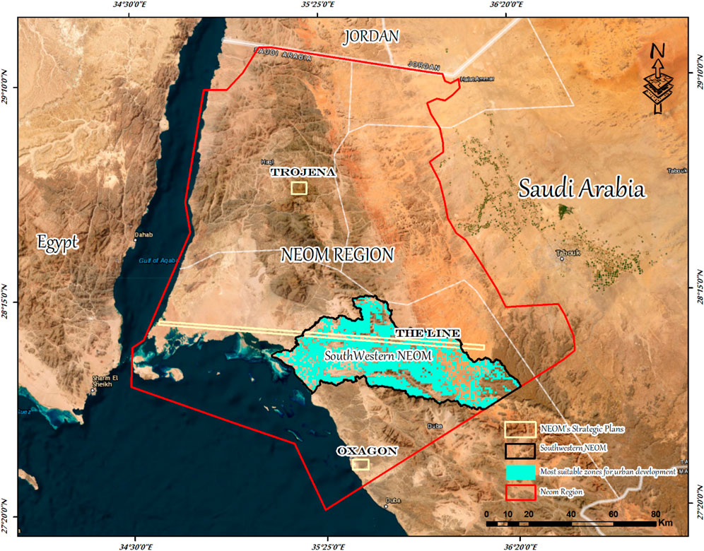
Figure 7. Aligning Final Model results with NEOM’s Strategic Development Initiatives.
The outputs from the Southwestern NEOM model, highlighted in Figure 7, align with NEOM’s strategic visions, particularly verifying the proposed location for The Line. This site is deemed suitable based on its accessibility, terrain adaptability, and capacity for integrating renewable energy and sustainable water practices, thus supporting the strategic objectives and placement of the initiative.
The coherence between the model’s findings and NEOM’s strategic directives underscores the model’s value as an instrumental tool in pinpointing areas suitable for varied development purposes, thereby enhancing its role in strategic urban planning. The analytical review provides insights that could refine NEOM’s land utilization and development tactics, suggesting a strategy that marries innovation with ecological conservation. It pinpoints regions where development is consistent with sustainability objectives and identifies areas where environmental preservation should take precedence.
This integrated analysis of GIS-based suitability assessments with NEOM’s designated projects offers an in-depth perspective on the developmental prospects of the region. It affirms the strategic insight behind NEOM’s planning endeavors and suggests areas where a stronger focus on environmental sustainability could improve the overarching development strategy. This methodology ensures that NEOM’s ambition to blend technological advancements with ecological stewardship and a dedication to sustainability is achieved, facilitating a balanced integration of development and nature conservation for the future.
The findings of this study, which focused on Southwestern NEOM suggest that the integrated geospatial framework used can be applied to regions facing challenges, in managing urban growth and sustainability. The approach and methodology employed in this study can be adapted to contexts that have access to relevant spatial datasets. These datasets include satellite imagery, digital elevation data, land use maps, and infrastructure location information. Many government agencies now maintain databases enabling reproducibility of the study.
However, it is important to note that the specific weighting and importance assigned to economic and sociocultural factors may need to be calibrated based on the developmental priorities and policy targets of each region. For example, countries that prioritize growth might emphasize factors like proximity to roads or power supply facilities in their site suitability models. The framework discussed here can also be modified for regions by considering factors such as proximity to suitable croplands, compatibility of crops, with elevation levels, soil conditions, etc. In tourism zones, marine conservation criteria could be incorporated into models. The level of analysis resolution can also be customized depending on the availability of data. While high-resolution assessments offer precision moderate resolutions may suffice for providing regional zoning guidance.
By customizing parameters, constraints, weighting schemes, and resolutions to fit the context this evidence-based approach, to site suitability, can be applied to locations. It offers planners a foundation, for making planning decisions that are tailored to the circumstances of each location.
The analysis highlights that coastal regions along the Red Sea and neighboring plains hold high development potential due to their ability to boost maritime and transportation networks, facilitate desalination processes, and promote the tourism sector. Strategic development in these areas could spur regional economic diversification, in alignment with Vision 2030's objective to lessen dependence on oil (Samargandi et al., 2024). For inland regions, the study indicates a moderate suitability for development. Utilizing these areas could involve expanding urban development along existing transportation routes to link underdeveloped regions with major economic hubs.
Incorporating socio-cultural elements in the planning process emphasizes the need to preserve cultural heritage sites. Consistent with Vision 2030’s focus on cultural heritage (Mazzetto, 2024), creating protected zones around these sites can preserve the cultural identity while enhancing tourism potential. Moreover, engaging with local communities, including the Bedouin populations, is crucial for ensuring that development projects are culturally considerate and support traditional ways of life, enhancing social sustainability.
NEOM’s strategic initiatives like The Line, Oxagon, and TROJENA present unique opportunities for pioneering futuristic urban planning that harmonizes advanced development with ecological and cultural conservation (Aldlbahi, 2024). The spatial analysis from this study can inform the placement and scale of these initiatives, ensuring they are strategically situated to maximize natural resource use and minimize environmental degradation.
Given the region’s water scarcity, sustainable water management is imperative. Our findings advocate for innovative solutions such as desalination and efficient water management systems. These measures are vital for maintaining a reliable water supply for both urban development and agriculture, essential for NEOM’s long-term sustainability.
Overall, our research offers a comprehensive framework for planning and implementing development that aligns with Saudi Vision 2030. By prioritizing areas deemed most suitable and weaving socio-economic and cultural considerations into the planning process (Salman, 2024), it is feasible to cultivate a balanced and sustainable development paradigm that supports national objectives.
In our study on Geospatial Modeling of Optimal Zones for Sustainable Urbanization in Southwestern NEOM, Saudi Arabia, the Data Acquisition and Results and Discussion sections have demonstrated the meticulous approach and thorough methodologies utilized to achieve the overarching goals of sustainable urban development. During the data acquisition phase, we engaged in a comprehensive collection of geographical and environmental data, leveraging high-resolution satellite imagery and various thematic maps to create a detailed depiction of the Southwestern NEOM region. This process was integral in ensuring the accuracy and depth of the data, which formed the basis for our analysis.
In the Results and Discussion, we reported on the effective use of GIS-based models and the Analytical Hierarchy Process (AHP) to assess the suitability of different areas for urban development. The models identified zones along the coastal regions and adjacent plains as highly suitable for development, considering their potential for desalination and tourism, and their proximity to critical infrastructure such as the upcoming NEOM airport and high-speed railway links. This not only underscores the strategic location of these areas but also aligns with the Saudi Vision 2030 by promoting economic diversification and sustainable growth.
The combination of these efforts has resulted in a robust framework for urban planning that aligns with environmental conservation and sustainable development goals. By integrating socio-economic and cultural considerations, our study provides a balanced approach to urban development, ensuring that new infrastructures are both ecologically sensitive and strategically positioned to support long-term growth and community wellbeing in Southwestern NEOM.
The original contributions presented in the study are included in the article/Supplementary material, further inquiries can be directed to the corresponding author.
HA: Writing–review and editing, Resources, Funding acquisition. AK: Writing–review and editing, Project administration, Formal Analysis. IA: Writing–review and editing, Validation, Funding acquisition. RR: Writing–review and editing, Supervision, Methodology, Data curation. MR: Writing–review and editing, Writing–original draft, Visualization, Validation, Supervision, Software, Resources, Project administration, Methodology, Investigation, Funding acquisition, Formal Analysis, Data curation, Conceptualization.
The author(s) declare that financial support was received for the research, authorship, and/or publication of this article. This research was funded by the Deanship of Scientific Research, Princess Nourah bint Abdulrahman University, through the funding program for targeted research number (PNU-Targeted-I).
We would like to express our gratitude to Dr. Ali M. Zeidan for his contributions to the preliminary research that greatly enhanced the quality of this work. His expertise and insights were invaluable during the early stages of this study.
The authors declare that the research was conducted in the absence of any commercial or financial relationships that could be construed as a potential conflict of interest.
All claims expressed in this article are solely those of the authors and do not necessarily represent those of their affiliated organizations, or those of the publisher, the editors and the reviewers. Any product that may be evaluated in this article, or claim that may be made by its manufacturer, is not guaranteed or endorsed by the publisher.
AbdelRahman, M. A., Natarajan, A., and Hegde, R. (2016). Assessment of land suitability and capability by integrating remote sensing and GIS for agriculture in Chamarajanagar district, Karnataka, India. Egypt. J. Remote Sens. Space Sci. 19 (1), 125–141. doi:10.1016/j.ejrs.2016.02.001
Abdullahi, S., Pradhan, B., Mansor, S., and Shariff, A. R. M. (2015). GIS-based modeling for the spatial measurement and evaluation of mixed land use development for a compact city. GIScience Remote Sens. 52 (1), 18–39. doi:10.1080/15481603.2014.993854
Abusaada, H., Elshater, A., and Rashed, R. (2023). Exploring the singularity of smart cities in the new administrative capital city, Egypt. Ain Shams Eng. J. 14 (9), 102087. doi:10.1016/j.asej.2022.102087
Aina, Y. A. (2017). Achieving smart sustainable cities with GeoICT support: the Saudi evolving smart cities. Cities 71, 49–58. doi:10.1016/j.cities.2017.07.007
Aklan, M., Al-Komaim, M., and De Fraiture, C. (2023). Site suitability analysis of indigenous rainwater harvesting systems in arid and data-poor environments: a case study of Sana’a Basin, Yemen. Environ. Dev. Sustain. 25 (8), 8319–8342. doi:10.1007/s10668-022-02402-7
Aldlbahi, S. M. M. (2024). Environmental adaptation tools as an approach to meet challenges in urban planning in the kingdom of Saudi Arabia. IOP Conf. Ser. Earth Environ. Sci. 1283, 012003. doi:10.1088/1755-1315/1283/1/012003
Alkhalidi, A., Qoaider, L., Khashman, A., Al-Alami, A. R., and Jiryes, S. (2018). Energy and water as indicators for sustainable city site selection and design in Jordan using smart grid. Sustain. Cities Soc. 37, 125–132. doi:10.1016/j.scs.2017.10.037
Alogayell, H. M., Kamal, A., Alkadi, I. I., Ramadan, M. S., Ramadan, R. H., and Zeidan, A. M. (2024). Spatial modeling of land resources and constraints to guide urban development in Saudi Arabia’s NEOM region using geomatics techniques. Front. Sustain. Cities 6, 1370881. doi:10.3389/frsc.2024.1370881
Alsubeh, M. A., and Helmi, M. R. (2024). Examining the sustainable impact of urban expansion and urban expansion policies on archaeological sites: evidence from Jordan and Saudi Arabia. Int. J. Low-Carbon Technol. 19, 603–612. doi:10.1093/ijlct/ctae020
Aminu, M. (2007) A geographic information system (GIS) and multi-criteria analysis for sustainable tourism planning Universiti Teknologi Malaysia.
Amr, A. I. (2023). Towards a more sustainable use of urban water for the residential urban landscapes of Egypt’s new desert cities.
Analytica, O. (2022) NEOM is a key part of Saudi Arabia’s green rebranding. Emerald Expert Briefings oxan-db.
Asakereh, A., Soleymani, M., and Sheikhdavoodi, M. J. (2017). A GIS-based Fuzzy-AHP method for the evaluation of solar farms locations: case study in Khuzestan province, Iran. Sol. Energy 155, 342–353. doi:10.1016/j.solener.2017.05.075
Bailey, D. T. (2005) Development of an optimal spatial decision-making system using approximate reasoning. Queensland University of Technology.
Belaïd, F., Amine, R., and Massie, C. (2023). “Smart cities initiatives and perspectives in the MENA region and Saudi Arabia,” in Smart cities: social and environmental challenges and opportunities for local authorities (Cham: Springer International Publishing), 295–313.
Boelt, W. (2014). UN General Assembly’s Open Working Group proposes sustainable development goals. U. N. Dep. Public Inf. 2.
Borana, S., and Yadav, S. (2023). “Urban land-use susceptibility and sustainability—case study,” in Water, land, and forest susceptibility and sustainability (Elsevier), 261–286.
Dastgoshade, S., Hosseini-Nasab, H., and Mehrjerdi, Y. Z. (2024). Investigating of transportation systems development for urban districts, costs and social equity: a case of Sanandaj, Kurdistan. OPSEARCH 61 (1), 373–398. doi:10.1007/s12597-023-00697-2
Du, H. S., Colovic, A., and Williams, C. (2023). Guest editorial: FDI and cities: city location attractiveness for FDI, the dynamics and co-evolution of FDI and urban development. Compet. Rev. Int. Bus. J. 33 (3), 505–511. doi:10.1108/cr-03-2023-192
Effat, H. A., Ramadan, M. S., and Ramadan, R. H. (2022). A spatial model for assessment of urban vulnerability in the light of the UN New Urban Agenda guidelines: case study of Assiut City, Egypt. Model. Earth Syst. Environ. 8 (3), 3687–3706. doi:10.1007/s40808-021-01281-7
Fischer, T. B. (2023) Strategic environmental assessment in transport and land use planning. Routledge.
González-Méndez, M., Olaya, C., Fasolino, I., Grimaldi, M., and Obregón, N. (2021). Agent-based modeling for urban development planning based on human needs. Conceptual basis and model formulation. Land Use Policy 101, 105110. doi:10.1016/j.landusepol.2020.105110
Govindan, K., Loisi, R. V., and Roma, R. (2016). Greenways for rural sustainable development: an integration between geographic information systems and group analytic hierarchy process. Land Use Policy 50, 429–440. doi:10.1016/j.landusepol.2015.10.016
Günel, G. (2019) Spaceship in the desert: energy, climate change, and urban design in Abu Dhabi. Duke University Press.
Hakam, O., Baali, A., Azennoud, K., Lyazidi, A., and Bourchachen, M. (2023). Assessments of drought effects on plant production using satellite remote sensing technology, GIS and observed climate data in northwest Morocco, case of the lower sebou basin. Int. J. Plant Prod. 17, 267–282. doi:10.1007/s42106-023-00236-5
Keshkamat, S. S., Looijen, J. M., and Zuidgeest, M. H. (2009). The formulation and evaluation of transport route planning alternatives: a spatial decision support system for the via Baltica project, Poland. J. Transp. Geogr. 17 (1), 54–64. doi:10.1016/j.jtrangeo.2008.04.010
Kutty, N. A., Barakat, D., Darsaleh, A. O., and Kim, Y. K. (2023). A systematic review of climate change implications on building energy consumption: impacts and adaptation measures in hot urban desert climates. Buildings 14 (1), 13. doi:10.3390/buildings14010013
Lötz, J.-F. (2023) Identifying suitable land uses and possible conflicts through LUCIS analysis and including localised geological circumstances. South Africa: JB Marks and City of Matlosana local municipalities, South Africa as case studies North-West University.
Mazzetto, S. (2024). Urban heritage conservation in Saudi Arabia toward sustainable reuses. Adv. Sci. Technol. 137, 79–86. doi:10.4028/p-umk0gc
Mishra, P. (2023) Sustainable Smart cities: enabling technologies, energy trends and potential applications. Springer Nature.
Ramadan, M. S., and Effat, H. A. (2021). Geospatial modeling for a sustainable urban development zoning map using AHP in Ismailia Governorate, Egypt. Egypt. J. Remote Sens. Space Sci. 24 (2), 191–202. doi:10.1016/j.ejrs.2021.01.003
Ramadan, M. S., Khairy, N., Alogayell, H. M., Alkadi, I. I., Ismail, I. Y., and Ramadan, R. H. (2022a). Spatial equity priority modeling of elementary and middle schools through GIS techniques, el-taif city, Saudi Arabia. Sustainability 14 (19), 12057. doi:10.3390/su141912057
Ramadan, R. H., Ramadan, M. S., Alkadi, I. I., Alogayell, H. M., Ismail, I. Y., and Khairy, N. (2022b). Assessment of sustainable world heritage areas in Saudi Arabia based on climate change impacts on vulnerability using RS and GIS. Sustainability 14 (23), 15831. doi:10.3390/su142315831
Rana, M. S. P., and Moniruzzaman, M. (2023). Potential application of GIS and remote sensing to evaluate suitable site for livestock production in Northwestern part of Bangladesh. Watershed Ecol. Environ. 5, 161–172. doi:10.1016/j.wsee.2023.07.001
Riadh, A.-D. (2022). Dubai, the sustainable, smart city. Renew. Energy Environ. Sustain. 7, 3. doi:10.1051/rees/2021049
Saaty, T. L. (1977). A scaling method for priorities in hierarchical structures. J. Math. Psychol. 15 (3), 234–281. doi:10.1016/0022-2496(77)90033-5
Saaty, T. L. (1994) Fundamentals of decision making and priority theory with the analytic hierarchy process. RWS publications.
Salman, Z. (2024) Assessing Saudi arabia's vision 2030: economic diversification, social inclusion, and environmental preservation through the triple bottom line lens. In.
Samargandi, N., Islam, M. M., and Sohag, K. (2024). Towards realizing vision 2030: input demand for renewable energy production in Saudi Arabia. Gondwana Res. 127, 47–64. doi:10.1016/j.gr.2023.05.019
Sankaran, V., and Chopra, A. (2020). Creating global sustainable smart cities (a case study of Masdar City). J. Phys. Conf. Ser. 1706, 012141. doi:10.1088/1742-6596/1706/1/012141
Saqr, A. M., Ibrahim, M. G., Fujii, M., and Nasr, M. (2021). Sustainable development goals (SDGs) associated with groundwater over-exploitation vulnerability: geographic information system-based multi-criteria decision analysis. Nat. Resour. Res. 30, 4255–4276. doi:10.1007/s11053-021-09945-y
Sharma, J., Arora, M., and Alsharef, A. (2022). “An illustrative study on multi criteria decision making approach: analytical hierarchy process,” in 2022 2nd international conference on advance computing and innovative technologies in engineering (ICACITE).
Taiema, F. S., and Ramadan, M. S. (2021). Monitoring urban growth directions using geomatics techniques, a case study Zagazig city-Egypt. Egypt. J. Remote Sens. Space Sci. 24 (3), 1083–1092. doi:10.1016/j.ejrs.2021.10.007
Tiwari, V., Kumar, A., and Mukherjee, M. (2024). GIS and AHP-based groundwater recharge potential zones in urban region: a study of Ajmer City, Rajasthan, India. Urban Clim. 54, 101840. doi:10.1016/j.uclim.2024.101840
Un-Habitat, M. (2019) Saudi cities report 2019. Pdf united nations human settlements programme. Nairobi, Kenya: Ministry of Municipal and Rural Affairs, Riyadh, Saudi Arabia. Available at: https://unhabitat.org/sites/default/files/2020/05/saudi_city_report.english.pdf (Accessed May 08, 2020).
van Herwijnen, M., Janssen, R., and Nijkamp, P. (1993). A multi-criteria decision support model and geographic information system for sustainable development planning of the Greek islands. Proj. Apprais. 8 (1), 9–22. doi:10.1080/02688867.1993.9726881
Wang, X., and Mell, I. (2019). Evaluating the challenges of eco-city development in China: a comparison of Tianjin and Dongtan eco-cities. Int. Dev. Plan. Rev. 41 (2), 215–242. doi:10.3828/idpr.2019.8
Watuwaya, B., Syamsu, J., Budiman, B., and Useng, D. (2023). The role of remote sensing and GIS to support grassland identification. case study: east Sumba Regency, East Nusa Tenggara Province, Indonesia. AIP Conf. Proc. doi:10.1063/5.0144198
Yang, F., Zeng, G., Du, C., Tang, L., Zhou, J., and Li, Z. (2008). Spatial analyzing system for urban land-use management based on GIS and multi-criteria assessment modeling. Prog. Nat. Sci. 18 (10), 1279–1284. doi:10.1016/j.pnsc.2008.05.007
Yusuf, N., and Abdulmohsen, D. (2022). Saudi Arabia’s NEOM project as a testing ground for economically feasible planned cities: case study. Sustainability 15 (1), 608. doi:10.3390/su15010608
Zhang, H., Zhao, X., Ren, J., Hai, W., Guo, J., Li, C., et al. (2023). Research on the slope gradient effect and driving factors of construction land in urban agglomerations in the upper yellow river: a case study of the lanzhou–xining urban agglomerations. Land 12 (4), 745. doi:10.3390/land12040745
Keywords: optimal site suitability, GIS, remote sensing, AHP, sustainability, urban development, southwestern Neom
Citation: Alogayell HM, Kamal A, Alkadi II, Ramadan RH and Ramadan MS (2024) Geospatial modeling of optimal zones for sustainable urbanization in southwestern NEOM, Saudi Arabia using geomatics techniques. Front. Built Environ. 10:1379269. doi: 10.3389/fbuil.2024.1379269
Received: 30 January 2024; Accepted: 24 April 2024;
Published: 12 June 2024.
Edited by:
Shimaa Azab, Institute of National Planning (INP), EgyptReviewed by:
Mahua Mukherjee, Indian Institute of Technology Roorkee, IndiaCopyright © 2024 Alogayell, Kamal, Alkadi, Ramadan and Ramadan. This is an open-access article distributed under the terms of the Creative Commons Attribution License (CC BY). The use, distribution or reproduction in other forums is permitted, provided the original author(s) and the copyright owner(s) are credited and that the original publication in this journal is cited, in accordance with accepted academic practice. No use, distribution or reproduction is permitted which does not comply with these terms.
*Correspondence: Mona S. Ramadan, bW9uYS5zLnJhbWFkYW5AdWFldS5hYy5hZQ==
Disclaimer: All claims expressed in this article are solely those of the authors and do not necessarily represent those of their affiliated organizations, or those of the publisher, the editors and the reviewers. Any product that may be evaluated in this article or claim that may be made by its manufacturer is not guaranteed or endorsed by the publisher.
Research integrity at Frontiers
Learn more about the work of our research integrity team to safeguard the quality of each article we publish.